The role of climate-fuel feedbacks on Holocene biomass burning in upper-montane Carpathian forests
Vachel A. Carter, Přemysl Bobek, Alice Moravcová, Anna Šolcová, Richard C. Chiverrell, Jennifer L. Clear, Walter Finsinger, Angelica Feurdean, Ioan Tanţău, Enikő Magyari, Tom Brussel, Petr Kuneš
PII: S0921-8181(20)30155-7
DOI: https://doi.org/10.1016/j.gloplacha.2020.103264
Reference: GLOBAL 103264
To appear in: Global and Planetary Change Received date: 23 September 2019
Revised date: 18 May 2020 Accepted date: 17 June 2020
Please cite this article as: V.A. Carter, P. Bobek, A. Moravcová, et al., The role of climate- fuel feedbacks on Holocene biomass burning in upper-montane Carpathian forests,Global and Planetary Change(2019),https://doi.org/10.1016/j.gloplacha.2020.103264
This is a PDF file of an article that has undergone enhancements after acceptance, such as the addition of a cover page and metadata, and formatting for readability, but it is not yet the definitive version of record. This version will undergo additional copyediting, typesetting and review before it is published in its final form, but we are providing this version to give early visibility of the article. Please note that, during the production process, errors may be discovered which could affect the content, and all legal disclaimers that apply to the journal pertain.
© 2019 Published by Elsevier.
The role of climate- fuel feedbacks on Holocene biomass burning in upper-montane Carpathian forests
Vachel A. Carter1,*vachel.carter@gmail.com, Přemysl Bobek2, Alice Moravcová1, Anna
Šolcová1,2, Richard C. Chiverrell3, Jennifer L. Clear4,5, Walter Finsinger6, Angelica Feurdean7,8,9, Ioan Tanţău9, Enikő Magyari10,11,12, Tom Brussel13, Petr Kuneš1
1Department of Botany, Faculty of Science, Charles University, Prague, Czech Republic
2Institute of Botany, The Czech Academy of Sciences, Průhonice, Czech Republic
3Department of Geography and Planning, University of Liverpool, Liverpool, United Kingdom
4Department of Geography and Environmental Science, Liverpool Hope University, Liverpool, United Kingdom
5Department of Forest Ecology, Czech University of Life Sciences, Prague, Czech Republic
6ISEM, University Montpellier, CNRS, EPHE, IRD, Montpellier, France
7Department of Physical Geography, Goethe University, Altenhöferallee 1, 60438 Frankfurt am Main, Germany,
8Senckenberg Biodiversity and Climate Research Centre (BiK-F), Senckenberganlage, 25, 60325, Frankfurt am Main, Germany
9Department of Geology, Babeş-Bolyai University, 400084 Cluj-Napoca, Romania
10Department of Environmental and Landscape Geography, Eötvös Loránd University, Budapest, Hungary
11MTA-MTM-ELTE Research Group for Paleontology, Budapest, Hungary
12GINOP Sustainable Ecosystems Group, MTA Centre for Ecological Research, Tihany, Hungary
13Department of Geography, University of Utah, Salt Lake City, Utah, USA
Journal Pre-proof
Abstract
Over the past few decades, mean summer temperatures within the Carpathian Mountains have increased by as much as 2 oC leading to a projected increased forest fire risk. Currently, there are no paleofire records from the Western Carpathians that provide the long-term range of natural variability to contextualise the response of upper-montane forests to future environmental change and disturbance regimes. We present the first high-resolution Holocene fire history record from the upper-montane ecotone from the High Tatra Mountains, Slovakia, as well as provide a regional synthesis of pan-Carpathian drivers of biomass burning in upper-montane forests. Our results illustrate that forest composition and density both greatly influence biomass burning in these hotspots for biodiversity, creating two different climate- fuel feedbacks. First, warmer conditions occurred in the early Holocene, coupled with generally higher abundances of Pinus sp., either P. cembra and/or P. mugo/sylvestris, created a positive climate- fuel relationship that resulted in higher amounts of biomass burning. Second, cooler and wetter late Holocene
conditions led to denser Picea abies upper-montane forests, creating a negative climate- fuel feedback that reduced biomass burning in upper-montane forests across the Carpathians. Given that warmer and drier conditions are expected across the entire Carpathian region in the future, our results illustrate how future climate change could potentially create a positive climate-fuel relationship within upper-montane forests dominated by Picea abies and Pinus cembra and/or P.
mugo/sylvestris.
Keywords
Journal Pre-proof
Fire; Upper-montane; Carpathians; Holocene; Sedimentary charcoal; Pollen; Macrofossils; Picea abies; forest composition; forest density
1 Introduction
Mountain forests are important ecosystems providing an array of ecosystem goods and services, with roughly half of the global human population depending upon these services (Körner and Ohsawa, 2005). Mountain forests are also key hotspots for biodiversity, with higher levels of endemic richness as a result of high environmental heterogeneity and geographic isolation (Noroozi et al., 2018). In Europe, forests cover 41% of the total mountain area with the majority of forest cover occurring in the Alps, Carpathians and Pyrenees Mountains (Price et al., 2011). Unfortunately, mountain forests are among the most sensitive ecosystems to climate change, with high mountain environments experiencing more rapid changes in temperature than low-elevation environments (Pepin et al., 2015). Since 2001, all major European alpine systems have witnessed an increasing trend in warm-adapted species (Gottfried et al., 2012), illustrating their sensitivity to warmer temperatures. Given that climate influences significantly the structure, composition and function of high mountain ecosystems (Prentice et al., 1992), climate- induced changes are likely going to be more pronounced near the upper treeline (Harsch et al., 2009).
Norway spruce (Picea abies) is one of the most important economic trees in Europe, dominating the boreal forests in northern Europe and upper-montane/subalpine areas of the Alps and Carpathian Mountains (hereafter referred to as Carpathians) (Caudullo et al., 2016). Norway spruce is susceptible to both heat and drought due to its shallow root systems and may be
vulnerable to the increasing temperatures at high-elevations. In fact, Picea abies is currently listed as one of the most vulnerable tree species in the Carpathians due to increasing summer
Journal Pre-proof
temperatures (Linder et al., 2008), with both montane (1100–1500 m a.s.l) and subalpine (>1500 m a.s.l.) Picea abies forests projected to decline in extent with climate change (Werners et al., 2014). Mean summer temperatures in the Carpathians have increased by as much as 2 oC over the past few decades (Alberton et al., 2017), twice the global mean (Auer et al., 2007), which raises the prospect of greater sensitivity to climate change than montane forests elsewhere in Europe (UNEP, 2007). This sensitivity to climate change will likely propagate through the 21st century, with mean summer temperatures projected to increase by a further 1–2 oC across the Carpathians by the end of the century (Anders et al., 2014) in conjunction with heat waves and droughts. Projected changes in precipitation across the Carpathians are more varied but suggest greater seasonality with generally drier summers (Anders et al., 2014). If conditions continue as projected, drier conditions could lead to either a collapse and/or dieback of Picea abies,
compromising the provision of ecosystem services (Lévesque et al., 2013).
Many mountains forests including old growth Picea abies forests are declining and/or vanishing, especially within the Romanian arc of the Carpathians as a result of deforestation, poor management practices, and increased rates of forest disturbances linked to windthrow, bark beetle outbreak and fire events (Achard et al., 2009; Hlásny and Sitková, 2010; Feurdean et al., 2011; Knorn et al., 2012; 2013; Temperli et al. 2013; Grindean et al., 2019). These factors illustrate the sensitivity of Picea abies forests to human intervention, disturbance regimes, and climate change. Given that there is a high likelihood of increased fire risk among central and southern European ecosystems by the end of the 21st century (Lung et al., 2013), and that air temperature is a key variable for establishment and growth of high mountain forests (Körner and Paulsen, 2004), the coupled threat of future climate change and increased likelihood of fires potentially threatens upper-montane Picea abies forests across the Carpathians. This threat could
Journal Pre-proof
affect their ability to provide ecosystem services (Albrich et al., 2018), including negative impacts on key transboundary biosphere reserves (UNESCO-WNBR). However, there is currently a limited understanding regarding the long-term importance of fire in high mountain forests, specifically upper-montane Picea abies-dominated forests. This information is critical for conservation and management as Picea abies is also highly susceptible to other forest disturbances such as windthrow and bark beetle outbreaks. What limited understanding we have about fire activity in upper-montane forests throughout the Carpathians is from research mostly from the Eastern and Southern Carpathians, which demonstrate the importance of long-term fire occurrence these elevations (Geantă et al., 2014; Feurdean et al., 2012; 2017; Finsinger et al., 2018; Florescu et al., 2018). No long-term records of fire dynamics existed from the Western Carpathians until recent research, which is from the lower montane forest zone dominated by beech (Fagus sylvatica), silver fir (Abies alba), and an admixture of Norway spruce (Kołaczek et al., 2020).
Here, we present a new c.9500-year high-resolution paleoecological record from Popradské pleso located in the upper-montane forest zone in the High Tatra Mountains, Slovakia, Western Carpathians. We address the existing knowledge gap concerning the long- term history of fire in upper-montane forests in the Western Carpathians by comparing the new record with other high-resolution fire records from the upper-montane forest zone spanning the entire Carpathian region. Our objectives are to; 1) quantify the long-term variability in wildfire (biomass burning) regime and assess spatial differences across the wider Carpathian upper- montane forested ecosystem; 2) evaluate the respective roles of climate and humans as drivers of past biomass burning; 3) explore how forest composition and density modulates biomass burning in these upper-montane forest ecosystems; and 4) use the paleofire record to infer the potential
Journal Pre-proof
impacts of future climate warming (1–2 oC). Our study provides critical data for understanding the role of fire disturbance regimes in old growth spruce forests in the Carpathians, with utility for understanding the future dynamics of equivalent montane ecosystems elsewhere.
2 Study region
2.1. Popradské pleso in the Western Carpathians
Popradské pleso (pleso is Slovak for ‘glacial lake’) (49°09′13” N, 20°04′47” E, 1513 m a.s.l.) is located in the Mengusovská dolina valley, on the south slope of the central High Tatra Mountains (Figure 1). The High Tatra Mountains are a west-to-east trending mountain range along the Slovakia-Poland border situated within the Western Carpathians. This mountain range was heavily glaciated during the Last Glacial Maximum with the Mengusovská dolina valley hosting the largest glacier on the south slope (Zasadni and Kłapyta, 2014). Popradské pleso has a large catchment to lake area ratio (67.5:1), and a maximum water depth of ~18 m with a surface area of ~6.3–6.9 ha (Schaffer and Stummer, 1933; Pacl, 1973). The lake catchment has a granite- granodiorite bedrock and is surrounded by the tallest mountain peaks in the entire High Tatra region including the tallest mountain peak, Rysy (2500 m a.s.l.). The lake has one inflowing stream, Ľadový potok, on the northeast side, and one outflow stream, Krupá, on the south side.
Popradské pleso is located ~50 m downhill from the upper treeline in the upper-montane forest belt (Grodzińska et al., 2004), which is dominated by Norway spruce with an admixture of Swiss stone pine (Pinus cembra) and dwarf mountain pine (Pinus mugo). While beech (Fagus sylvatica) and Silver fir (Abies alba) are both common at these elevations in the Southern Carpathians, F. sylvatica is currently absent and A. alba is very rare at these elevations in the
Journal Pre-proof
High Tatras (Rybníčková and Rybníček, 2006). However, F. sylvatica is present at lower elevations near Štrbské Pleso (1358 m; see Kučera, 2012 and Flachbart, 2007).
Climate in the high Western Carpathian mountain zone is cold and moist, with the highest quantities of precipitation (2000 to 2400 mm yr-1) in the Carpathians occurring in the High Tatra Mountains (UNEP, 2007). Mean annual temperature and precipitation from the closest meteorological station to Popradské pleso, Štrbské Pleso, are 3.7 °C and 1826 mm (Slovak Hydrometeorological Institute), respectively. The local west-to-east mountain
orientation has resulted in a strong windward/leeward precipitation gradient with the north side receiving more precipitation than the south site (Koncek, 1974). Mean annual temperatures range between 2 to -4 oC in the coniferous belt dominated by Picea abies forests (Hess, 1965; 1974).
For the High Tatras, climate models suggest 2 oC warming alongside 5–8% decreases in summer precipitation, with ~10–15% increases in winter precipitation by the end of 21st century (Anders et al., 2014).
2.2. Eastern and Southern Carpathian study sites
Poiana Ştiol (47o35’14” N; 24o48’43” E, 1540 m a.s.l.; Feurdean et al., 2017) and Tăul Muced (47o34’26” N; 24o32’42” E, 1360 m a.s.l.; Feurdean et al., 2017) are both located in the Rodna National Park and Biosphere Reserve, Eastern Carpathians. Poiana Ştiol is a nutrient-poor fen located at the current treeline ecotone dominated by Picea abies, Pinus mugo, P. cembra and Juniperus communis ssp. nana (Tanţău et al., 2011; Feurdean et al., 2016). The surrounding forest is composed of ~80% Picea abies and ~20% Abies alba (Topographic Maps of Romania, 1986). Tăul Muced is an ombrotrophic bog within a closed conifer forest, with onsite woody vegetation consisting of Picea abies with P. mugo. The surrounding forest is comprised of ~40%
Journal Pre-proof
Picea abies and Abies alba and ~10% Fagus sylvatica (Topographic Maps of Romania, 1986).
The climate at Poiana Ştiol is slightly wetter than at Tăul Muced due to its higher altitude (1300 mm and 1200 mm, respectively). Mean annual temperature is 2–2.2 °C at both sites (Dragotă and Kucsicsa, 2011). For the Southern Carpathians, climate models suggest 2 oC warming alongside 10–15% decreases in summer precipitation, with ~10–15% increases in winter precipitation by the end of 21st century (Anders et al., 2014).
Lake Brazi (45o23’47” N; 22o54’6” E, 1740 m a.s.l.; Magyari et al., 2012) is a small (~0.4 ha), shallow lake (maximum water depth 1.1 m), located in the Retezat National Park, Retezat Mountains, Southern Carpathians. The site is located about 110 m below the timberline in a mixed conifer forest dominated by Picea abies and Pinus cembra, with P. mugo being restricted to the floating Sphagnum bog found along the lakeshore. Annual precipitation ranges between 900 and 1800 mm, while the mean annual temperature is around 6 °C in the foothill zone and -2 oC at 2500 m a.s.l. in the Retezat Mountains (Bogdan, 2008). For the Southern Carpathians, climate models suggest 2 oC warming alongside a 10–15% decrease in summer precipitation and a ~2–5% decrease in winter precipitation by the end of 21st century (Anders et al., 2014).
3 Methods 3.1 Field work
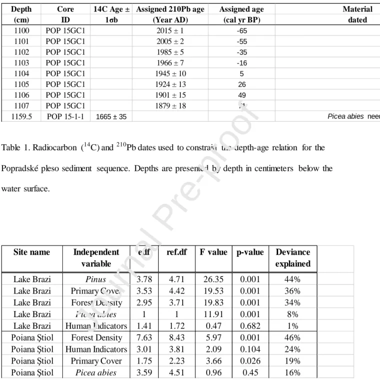
In September 2015, a 28 cm (POP 15-GC1) and a 4 m-long core (POP 15–1, drives 1–4) were extruded using a floating platform from the centre of Popradské pleso (water depth, 11 m).
The sediment water interface was collected using a short gravity corer (Boyle, 1995), while a Russian corer was used to collect the long-core sediments in 1.5 m overlapping sections.
Journal Pre-proof
Sediments were stored under refrigeration until they were subsampled at high-resolution (contiguous 0.5 cm intervals) for dating and geochemical analyses.
3.2 Lead 210 and radiocarbon dating
A total of 12 Accelerator Mass Spectrometry (AMS) radiocarbon (14C) ages and a radiometric 210Pb series were obtained to construct an age-depth model for Popradské pleso (Table 1). Most 14C ages were measured on terrestrial plant macrofossils, but in the section below 1371 cm below the water surface, ages were measured on bulk pollen concentrations because of the lack of macrofossils. Pollen extractions for bulk pollen concentrations were modified after Brown et al. (1989) using a dilute Schulze solution of 10% KClO3 and 35% HNO3
(Gray, 1965).
Radiometric dating targeted the upper 8 cm of the gravity core (POP-15-GC1), analysing for 210Pb, 226Ra, 137Cs and 241Am by direct gamma assay in the Liverpool University
Environmental Radioactivity Laboratory using Ortec HPGe GWL series well-type coaxial low background intrinsic germanium detectors (Appleby et al. 1986). 210Pb was determined via its gamma emissions at 46.5 keV, and 226Ra by the 295 keV and 352 keV-rays emitted by its daughter radionuclide 214Pb following 3 weeks storage in sealed containers to allow radioactive equilibration. 137Cs and 241Am were measured by their emissions at 662 keV and 59.5 keV respectively. The absolute efficiencies of the detectors were determined using calibrated sources and sediment samples of known activity. Corrections were made for the effect of self-absorption of low energy-rays within the sample (Appleby et al. 1992).
Journal Pre-proof
Age-depth relationships were modeled in a Bayesian framework using ‘BACON’ (Blaauw and Christen, 2011), including both the 210Pb and 14C dates. All 14C dates were calibrated using the IntCal13 dataset (Reimer et al., 2013).
3.3 Lithostratigraphy, magnetic susceptibility and geochemical analyses
Prior to subsampling, high resolution digital line-scan photographs of the Pop15-1 core were taken using the University of Liverpool Geotek Multi-sensor core logger (MSCL-XZ).
Geochemical data were determined non-destructively on a wet sediment basis at 5 mm resolution using an Olympus Delta ED-XRF (4 W) mounted to the Geotek. Cores were measured under Soil mode (40 kV, 40 kV (filtered) and 15 kV beam intensities) for heavier elements and MiningPlus mode (40 kV and 15 kV) for lighter elements. Each beam intensity ran for 20 seconds with total runs of 60 seconds (soil mode) and 40 seconds (mining plus). The Olympus XRF instrument is subject to daily consistency checks and regular testing using library of certified geochemical reference materials (Boyle et al., 2015). Element concentrations are expressed in ppm, but are subject to possible matrix effects induced by variable down-core water and organic content arising from measuring wet sediments. Magnetic susceptibility (XLF) was measured on a wet sediment basis at 5 mm intervals using a Bartington Instruments MS2E high resolution point sensor paired to the Bartington MS3 meter mounted on the Liverpool Geotek MSCL-XZ. The scan XLF data reveal changes between minerogenic (positive values) and organic or high-water content sediments (negative or diamagnetic values).
3.4 Plant macrofossils and pollen analysis
Journal Pre-proof
Pollen analysis was conducted contiguously at 1 cm resolution throughout the gravity core, and at 2.5 cm resolution throughout the long core from Popradské pleso. Pollen processing utilized standard acid-base rinse procedures (Faegri et al., 1989) using 0.5 cm3 of sediment per sample. A Lycopodium tablet was added to each sample prior-to pollen processing, and was used as an exotic tracer to calculate both pollen concentration (grains cm3) and pollen accumulation rates (pollen influx; grains cm-2 yr-1) (Stockmarr, 1972). A minimum of 500 terrestrial pollen grains were identified at a magnification of 400× with the aid of reference material and identification keys (Beug, 2004; Punt, 1976–1996). Pollen counts were converted into pollen percentages based on the abundance of each pollen type relative to the sum of all identified terrestrial pollen. The pollen profile was divided into pollen assemblage zones based on optimal splitting by sums-of-squares using the broken-stick model using the software, Psimpoll (Birks and Gordon, 1985; Bennett, 1996). Legacy pollen data from the wider Carpathian region were available from Poiana Ştiol, Tăul Muced and Lake Brazi (see Magyari et al., 2012; Tanţău et al., 2011; Grindean et al., 2019). To access changes in forest density, we calculated an index using the ratio of Picea abies pollen (a) to Pinus pollen (b) following Higuera et al. (2014).
Plant macrofossil analysis was conducted every 2.5 cm from Popradské pleso using standard procedures described by e.g. Birks (2007). Sediment volume was measured by water displacement in a measuring cylinder (1–5 ml), and then gently sieved through a 100 µm sieve.
Plant macrofossils were analysed using a stereomicroscope at a magnification of 15–50×, and were identified with the aid of identification keys (Cappers et al., 2006; Bojňanský and Fargašová, 2007; Katz et al., 1977; Tomlinson, 1985) and the herbarium collection at Charles University.
Journal Pre-proof
3.5 Charcoal analysis, fire-event detection, and change point analysis
Macroscopic charcoal was analysed at 1 cm resolution in both the gravity core and long core from Popradské pleso. Sediment sub-samples of 1 ml were left for 12 hours in 10 ml, 5%
solution of potassium hydroxide (KOH), to disaggregate organic matter. In order to bleach non- charred material, 5 ml of sodium hypochlorite (10% NaOCl) was added to the samples. The required length of bleaching process was adjusted according to the results of test specimens taken from the same sediment core. Samples were screened using a 125 μm sieve and washed into petri dishes. The majority of the non-charred organic particles were manually removed using a stereomicroscope before capturing images of charcoal fragments using a custom-built scanning device (www.microspock.cz). Images were analysed using ImageJ to count and measure the area of charcoal particles (Schneider et al., 2012). Macroscopic charcoal counts were transformed to concentrations (particles/area cm-3) and accumulation rates (CHARC (the number of particles cm-
2 yr-1).
The site-specific fire history was determined using the CharAnalysis software (Higuera et al., 2009). First, the CHARC record was interpolated to a constant temporal resolution of 30 years, which is based on the median sediment accumulation rate. Then, the charcoal record was decomposed into a background component (CHARback), and a peak component (CHARpeak), which represents either a single fire event or several temporally clustered fire events within the charcoal-source area. CHARback was calculated using a moving median smoothed with a 400- year moving-window that ensured a sufficient signal-to-noise index (SNI >3) (Kelly et al., 2011).
The residual series (CHARpeak) was obtained by subtracting CHARback from CHARC, as we assume additive processes are responsible for increased charcoal delivery to the sedimentary basin. Fire episodes were inferred from CHARpeak by fitting a Gaussian mixture model to each
Journal Pre-proof
overlapping 400-year window while assuming two sub-populations: CHARnoise and fire. This enables modelling both the mean and variance of the CHARnoise distribution locally. The CHARpeak exceeding the 99th percentile of the modeled CHARnoise distribution were considered peak events. Each peak that exceeded the locally defined threshold was statistically screened using the minimum-count test (p<0.05) (Higuera et al., 2010).
Change point analysis was used to determine significant changes in biomass burning (i.e.
periods of increased/decreased fire activity) for all charcoal records based on variations in both the mean and variance of CHARC using a penalty (β) = 6 log(n) (Killick and Eckley, 2014). We also tested the potential effect of sedimentation-rate change on change point detection following Finsinger et al. (2018) using the ‘change point’ v2.2.2 package (Killick and Eckley, 2014).
3.6 Regional biomass burning
To disentangle local and regional drivers of fire in upper-montane forests in the Carpathians, the use of multiple sites, elevations and quantitative inter-site comparisons are necessary (Gavin et al., 2006). To reconstruct regional variations in biomass burning over time, we compared the record from Popradské pleso to three previously analysed sedimentary charcoal profiles from Poiana Ştiol, Tăul Muced and Lake Brazi (Figure 1). These three sites were chosen based on the following criteria; 1) all sites are currently located in Picea abies-dominated forests at/near treeline; 2) all records are temporally well-constrained with limited hiatuses (see
Feurdean et al., 2015; 2016; Finsinger et al., 2014); and 3) pollen and high-resolution charcoal data are available from each site, and span the majority of the Holocene. All fire histories were determined using the CharAnalysis software (Higuera et al., 2009) and followed the same
Journal Pre-proof
methodologies presented in section 3.6 to allow for regional comparisons of biomass burning histories.
3.7 Local climate model
To reconstruct the influence of broad-scale changes in climate on fire activity at
Popradské pleso, we developed a locally-derived macrophysical climate model (MCM; Bryson, 2005) using meteorological data of the Slovak Hydrometeorological Institute from the closest weather station, Štrbské pleso. For more information about the MCM, please see Carter et al.
(2018).
3.8 Generalized Additive Models
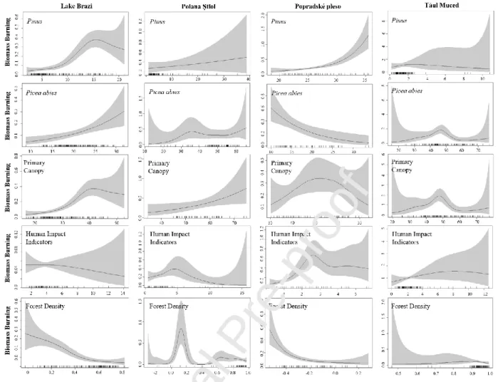
Generalized additive models (GAMs; Hastie and Tibshirani, 1986) use a link function to investigate the relationship between the mean of the response variable (i.e. dependent variable) and a smoothed function of the predictor variable (i.e. independent variable). In this study, we investigated the relationship between biomass burning (e.g. total CHARC from each of the four study sites) and Picea abies, Pinus, primary forest cover (i.e., the summed percentage values of Picea abies and Pinus), forest density (the ratio of Picea:Pinus), and human indicators. Given that many secondary human indicator taxa were naturally abundant in the early Holocene (Fyfe et al., 2015), we used a base period from 8000 cal yr BP to present in the model to remove any bias secondary indicator pollen taxa may have in the early Holocene before the intensification of human activity (see SI Table 1 for complete list of indicator taxa). We used a quasi-Poisson distribution with a log link function using the ‘mgcv’ package (Wood, 2017) in R. The GAMs were fit using restricted maximum likelihood smoothness selection.
Journal Pre-proof
4. Results
4.1 Popradské pleso chronology
The gravity core (POP-15-GC1) shows a very low accumulation rate with 210Pb/226Ra equilibrium at a depth of around 7 cm (Figure 2). The exponential decline in unsupported 210Pb concentrations with depth suggests a relatively uniform sedimentation rate throughout the period of time spanned by the 210Pb record. High 137Cs concentrations in the uppermost 2 cm most probably record fallout from the 1986 Chernobyl accident. Although the 137Cs record from nuclear weapons test fallout again appears to have been obscured by Chernobyl 137Cs, the 1963 fallout maximum is recorded by the presence of significant concentrations of 241Am between 2–4 cm. 210Pb ages calculated using the CRS and CIC models (Appleby and Oldfield 1978) both suggest a relatively uniform sedimentation rate since the middle of the 19th century with a mean value during that time of 0.0065 ± 0.0008 g cm-2 y-1 (0.048 cm y-1). These results place 1986 at a depth of between 1–2 cm and 1963 between 2–3 cm, in reasonable agreement with the depths suggested by the 137Cs and 241Am records. The base of the 210Pb age-depth model is consistent with European increases in airfall stable Pb concentrations in the sediment, associated with industrialization from the 1850’s onwards (Renberg et al., 2000).
Previous research from Popradské pleso suggested the possibility of a hiatus at the transition between the Late Glacial and the Holocene (Rybníčková and Rybníček, 2006). We found an age difference of ca. 4000 14C years between depths 1374.5 cm and 1371 cm below the water surface (Table 1). As core lithology changes dramatically at depth 1371.5 cm, transitioning from inorganic glacial sediments into organic-rich gyttja (Figure 3), we confirm the
sedimentation hiatus originally suggested by Rybníčková and Rybníček (2006). Due to multiple
Journal Pre-proof
age-reversals between the bottom of the core (depth 1635 cm) and depth 1373 cm, the age-depth model and the basal age for Popradské pleso are insufficiently constrained. Therefore, we will only present and discuss the section of the sedimentary profile reflecting continuous
accumulation spanning the Holocene (Figure 3).
4.2 Reconstructed vegetation dynamics at Popradské pleso
Summarising the dominant canopy taxa and significant changes in understory at
Popradské pleso, the pollen percentage profile was divided by six statistically significant pollen assemblage zones (SI Figure 1). Zone 1 (age undetermined; depth 1380–1370 cm) probably captures the Younger Dryas/Holocene transition, but due to a hiatus we were unable to confirm the exact ages of this zone. Regardless, this zone is characterized by high percentages of Pinus (>50%) and non-arboreal pollen (NAP; >20%), and by low percentages of Picea abies (<10%) similar to that found by Rybníčková and Rybníček (2006) (SI Figure 2). Low percentages of low-elevation arboreal species such as Corylus avellana were also recorded in this zone (SI Figure 1). No plant macrofossils were found in Zone 1. Zone 2 (9500–8500 cal yr BP; depth 1370–1355 cm) is characterized by an increase in Picea abies percentages (~15%), with
relatively high values of Picea abies influx values (~1000 grains cm-2 yr-1), the presence of Picea abies stomata, and high concentration of Picea abies macrofossils. Pinus percentages (~20%) and influx (>2000 grains cm-2 yr-1) values both declined from the previous zone, however Pinus stomata and macrofossils, both Pinus sp. and P. cembra are present throughout this zone (Figure 4). While total herbaceous percentages decreased to their lowest values, several herbaceous macrofossils were found in Zone 2, such as an Alchemilla sp. seed, a Caltha palustris/Trollius altissimus seed, and a Poaceae seed (SI Figure 1). Larix pollen was not found in Zone 2,
Journal Pre-proof
however, Larix decidua needles were found. Zone 3 (8500–5600 cal yr BP; depth 1355–1293 cm) can be characterized by the local dominance of Picea abies and Pinus with pollen
percentages averaging 15–20%, and pollen influxes averages 2823 grains cm-2 yr-1 and 3335 grains cm-2 yr-1. P. cembra needles decreased during this zone, while Pinus. sp (most likely P.
mugo) needles and bud scales increased. Corylus avellana percentages and influxes continued to decrease in this zone. High abundances of macrofossils were found at the onset of Zone 3; for example, seeds from Rubus idaeus, Alchemilla sp. and Juncus sp. and Rumex acetosa fruit. Zone 4 (5600–3900 cal yr BP; depth 1293–1248 cm) is notable in that both Abies alba and Fagus sylvatica pollen percentages and influxes slowly increase during this zone (SI Figure 1). Picea abies pollen percentages and influxes also increase to their highest values (~37% and ~7400 grains cm-2 yr-1) of the entire Holocene record before beginning a long-term declining trend.
Zone 5 (3900–800 cal yr BP; depth 1248–1133 cm) is characterized by a decreasing trend in both Picea abies pollen percentages and influxes, despite the high abundances of P. abies needles being recorded. Pinus pollen percentage values (~20%) were relatively stable, with high abundances of P. cembra needles being recorded in Zone 5. Abies alba and Fagus sylvatica reached their highest percentages (15% and 11%) and influx values (~1900 grains cm-2 yr-1 and 1160 grains cm-2 yr-1), and human impact indicator pollen percentages and influxes begin to increase during this zone. Sphagnum sp. capsules were also prominent in this zone. The final zone, Zone 6 (800 cal yr BP– present; depth 1133–1100 cm) is characterized by declining percentages of trees and shrubs, specifically Picea abies, Fagus sylvatica, and Abies alba.
However, pollen influx for each of these species shows rapid variability instead of a declining trend. Pollen percentages and influx values of Pinus and of human indicators increase throughout Zone 6. Macrofossils were not analysed from Zone 6.
Journal Pre-proof
4.3 Reconstructed fire and erosion history at Popradské pleso
Elevated CHARC values were recorded between 9000 and 7000 cal yr BP, with low values between 5500 and 1000 cal yr BP and then elevated values again in the last ~1000 years (Figure 4). The change-point analysis shows three periods of high biomass burning; 9000-7000 cal yr BP, around 6800 cal yr BP, and the past 2000 years (Figure 4). A total of 24 fire episodes were detected over the past 9500 years, with periods of increased fire frequency centred between 9000–8500 cal yr BP, 7000–6000 cal yr BP, and over the last 3000 years. During the past 200 years, one single event was identified in the CHARC record (see black circle, Figure 4).
However, based on documentary evidence, this is a false positive because no fire event has occurred at Popradské pleso over the last 200 years. The increase in CHARC is possibly due to the charcoal being produced from the Horský Hotel Popradské Pleso which was built on the shore of Popradské pleso in the mid-1800s. Fire frequency averages ~2.5 fires/1000 years (or a fire return interval of ~400 years) throughout the entire record.
XRF geochemical profiles for K, Ti, Rb and Zr (Boyle, 2011; Davies et al., 2015), alongside magnetic susceptibility (ΧLF) data (Dearing 1992; Oldfield et al., 2003), show changes in the flux of lithogenic elements from the granitic bedrock catchment. The inorganic stratigraphy (Figure 4) displays two types of behavior, 1) sharp and short-lived peaks and 2) changes in the background concentrations of these lithogenic markers. Ratios for the typically insoluble lithogenic elements, Zr and Rb, provide additional information on sediment grain size, with Zr typically coarse silt whereas Rb, Ti and K associate with finer fractions (Boyle, 2001;
Davies et al., 2015). The peaks in lithogenic elements occur throughout the Holocene, but are larger in magnitude 8500-7750, 6500-5500 and >4500 cal yr BP. Coincidentally, these periods
Journal Pre-proof
align with periods of increased biomass burning as detected by change point analysis. These peaks across all lithogenic elements reflect short-lived run-off extreme events (e.g. storms or rapid snowmelt), with coincident peaks in Zr/Rb reflecting the higher-energy riverine delivery of coarser sediments to the lake. For many layers, particularly >4500 cal. yr BP, the Zr/Rb peak often occurs early in the erosion event before finer grain size show declining energy in the event.
The background quantities for these lithogenic markers and the associated general erosion regime also changes, with lower concentrations for the earlier Holocene, but increasing in both their concentration and grain size (Zr/Rb) after 4500 cal yr BP.
4.4 Modeling biomass burning-vegetation relationships across the Carpathians
At Lake Brazi, biomass burning significantly increases with increasing Pinus and Picea abies abundance (p<0.001) and increasing primary forest cover (p<0.001), and significantly decreases with forest density (p<0.001) (Table 2). Human indicators have a negligible effect on biomass burning at Lake Brazi (p=0.682) (Figure 7). At Poiana Ştiol, biomass burning
significantly increases with increasing forest density (p<0.001) and primary forest cover (p<0.03). Both Pinus (p=0.319) and Picea abies (p=0.45) abundance and human indicators (p=0.104) all had insignificant effects on biomass burning. At Popradské pleso, Pinus and human indicators were both found to positively (p<0.001) influence biomass burning. Biomass burning decreased with increasing Picea abies (p<0.001) and increasing forest density (p<0.001) at Popradské pleso. Primary forest cover had a negligible effect on biomass burning at Popradské pleso (p=0.298). Finally, at Tăul Muced, biomass burning significantly increases with increasing primary forest cover (p<0.002) and Picea abies (p<0.003) pollen. Forest density (p=0.369),
Journal Pre-proof
human indicators (p=0.389), and Pinus pollen (p=0.624) all had insignificant effects on biomass burning.
5 Discussion
The new data on biomass burning (CHARC) from the High Tatra Mountains follows similar burning patterns to those experienced at the other upper-montane Carpathian sites during the Holocene (Figure 5). Both in the High Tatras as well as at other Carpathian sites, forests were dominated by Picea abies, a fire avoider species with minimal fire adaptations (Feurdean et al., 2017), and often associated with reduced fire activity (Ohlson et al., 2011). As a consequence, minimal biomass burning would be expected, yet biomass burning has been an agent of forest disturbance prevalent in the Carpathians through the Holocene.
5.1 Holocene wildfire activity across the Carpathians 5.1.1 Early and mid-Holocene
In the upper-montane forest zone, higher rates of biomass burning (i.e. total CHARC) were recorded between 10,000–6000 cal yr BP at Popradské pleso, Lake Brazi and Poiana Ştiol, as indicated by both change point analysis and increased fire frequencies (Figure 5). Higher CHARC is likely connected to broad-scale climate, with summer temperatures significantly warmer-than-present as a result of peak summer insolation (Berger and Loutre, 1991). Increased abundances of Pinus cembra and P. mugo macrofossils at Lake Brazi, (Finsinger et al., 2018), P.
cembra and Pinus sp. (likely either P. cembra or P. mugo) macrofossils at Popradské pleso (Figure 4), and P. sylvestris/mugo macrofossils at Poiana Ştiol (Feurdean et al., 2016) were found during the early and mid-Holocene suggesting a more open upper-montane landscape,
Journal Pre-proof
which is supported by lower Picea:Pinus ratio values until ~8500 cal yr BP (Figure 6). Warmer conditions in the early Holocene, coupled with generally higher abundances of Pinus sp. likely P. mugo or P. cembra, created a positive climate-fuel relationship that resulted in higher amounts of biomass burning. P. sylvestris may have potentially been present in the early Holocene, as its pollen is indistinguishable from P. mugo. Long-term paleoecological records indicate that the late-successional P. cembra is able to withstand moderately frequent surface fires, but not high anthropogenic fire activity (Ali et al., 2005; Genries et al., 2009; Blarquez and Carcaillet, 2010;
Schwörer et al., 2015), while the woody shrub, P. mugo, is favored by fire disturbances under drier conditions (Stähli et al., 2006; Leys et al., 2014). P. sylvestris is an early-successional species, fire-resister species, with a moderate-severity fire regime (Agee, 1988; Feurdean et al., 2017). Modeled Pinus response curves demonstrate a significant relationship with biomass burning at Lake Brazi and Popradské pleso (Table 2). This suggests that forest composition with higher amounts of P. mugo/sylvestris and/or P. cembra, despite the prevalence of Picea abies, may have been especially important for influencing biomass burning, especially at Lake Brazi and Popradské pleso.
High biomass burning during the early and mid-Holocene is witnessed across Europe (Marlon et al., 2013; Feurdean et al., 2012; 2013; 2017; Clear et al., 2014; Vannière et al., 2016;
Dietze et al., 2018; Florescu et al., 2019), as well as throughout the Western Carpathian region.
For example, in the Polish Western Carpathians, biomass burning was highest between 10,000–
9500 cal yr BP and 7500–6000 cal yr BP at lower-montane forests (Kołaczek et al., 2020). At Belianske lúky, Slovakia’s largest spring fen located near the foothills of the High Tatra Mountains approximately 30 km from Popradské pleso, high macrocharcoal abundances were recorded ~8500 cal yr BP as a result of drier conditions (Hájková et al., 2012). These results
Journal Pre-proof
from Belianske lúky generally agree with high CHARC values at Popradské pleso. However, at Popradské pleso, both CHARC and fire frequency decrease and remaine low, while indicators for soil erosions (i.e. K, Ti, Rb and XLF) all increase between 8400 and 7000 cal yr BP (Figure 3).
Interestingly, this time period overlaps with a potential sediment hiatus in the Polish Carpathian Mountains as a result of wetter conditions which caused the loss of sediment deposits (Kołaczek et al., 2020). Increased erosion is also recorded in both the Beskid Makowski Mountains and Beskid Wyspowy Mountains during this same time period (Margielewski, 2006; 2018). The time period between 8400 and 7000 cal yr BP overlaps with a period of global rapid climate changes (Mayweski et al., 2004), that is well documented across the entire Carpathian region, either by an increase in moisture (Hájková et al., 2016; Jamrichová et al., 2018; Šolcová et al., 2018;
Dabkowski et al., 2019), reoccurring fire events (Pál et al., 2016; 2018; Vincze et al., 2017;
Florescu et al., 2019), or as a change in climatic conditions or erosion activity (Schnitchen et al., 2006; Feurdean et al., 2008; Tóth et al., 2015; Gałka et al., 2020). Together, this data suggests climate as the ultimate driver of biomass burning in the Carpathians in the early and mid- Holocene.
However, archaeological evidence demonstrates human occupation and activity near the High Tatra Mountains and throughout the Carpathian Basin since at least the Mesolithic period
~10,000 cal yr BP (Valde-Nowak and Soják, 2010; Kertész, 2002 and references therein).
Florescu et al. (2018) found an increase in biomass burning ~8500 cal yr BP in the Southern Carpathians which coincided with a slight increase in meadow and pasture pollen types,
suggesting that Early-Middle Neolithic (~8000 cal yr BP) populations occupied montane forest- elevations in the Southern Carpathians. Both Cerealia and Secale were first identified at Tăul Muced ~7300 cal yr BP (Feurdean et al., 2017) illustrating a long history of human occupation in
Journal Pre-proof
the Southern Carpathians. Similarly, others have also documented, or hinted at the possible presence of humans at montane-elevations in the Southern Carpathians in the late Neolithic (Fărcaş et al., 2003; 2013; Feurdean et al., 2016; 2017). However, because certain taxa typically classified as secondary human indicator species (e.g. Rumex, Poaceae, Plantago) are apophytes and were naturally and abundantly present during the early Holocene, these data were left out of the GAMS model prior to 8000 cal yr BP, and thus our results are only indicative of
anthropogenic activity post 8000 cal yr BP. It may be that Mesolithic and Neolithic populations were foraging seasonally among the Carpathians both in the lowlands and at higher-elevations, however, palynological evidence does not illustrate large-scale changes in vegetation at any of the study sites (Figure 5). While low density Mesolithic/Neolithic populations could have contributed to the overall rate of biomass burning in the early and mid-Holocene, we suggest climate was the ultimate driver of early and mid-Holocene burning in upper-montane forests.
5.1.2 Mid to late Holocene
Biomass burning was reduced in the regions’ upper-montane forest zone from ~6000 to
~2000 cal yr BP (Figure 5) as a result of cooler and wetter conditions. Cooler and wetter conditions led to denser Picea abies upper-montane forests (Figure 6), which naturally
modulated biomass burning by regulating understory microclimates (Chen et al., 1999; Davis et al., 2018). Thus, this coupled climate- fuel relationship led to an overall reduction in biomass burning in upper-montane forests across the Carpathians (Feurdean et al., 2020). However, despite the dominance of Picea abies, fires were not excluded from this forest type, which is illustrated by relatively moderate fire frequencies (~2 fires/1000 years) at most sites (Figure 5).
Journal Pre-proof
At Popradské pleso, a substantial change in the erosion regime occurred ~4000 cal. yr BP, with the gradual increase in the baseline concentrations for lithogenic markers (Zr, K, Ti, Rb and XLF) showing a persistent shift to greater erosion (Figure 4). Increased frequency of coarser and mineral rich layers from ~4000 cal. yr BP suggest also an intensification of the run-off events (e.g. storms or rapid snowmelt) (Schillereff et al., 2014; 2019; Chiverrell et al., 2020).
Together, the long-term baseline concentrations and events (i.e. peaks) shown in the erosion proxies both point to increases in moisture and mineral in-wash. Soil erosion processes are highly dependent upon the magnitude of rainfall events (Schumacher at al., 2016), which the MCM model demonstrates is highly variable over the last 4000 years at Popradské pleso (Figure 4; summer precipitation curve). We therefore hypothesize that an increase in summer
precipitation could have potentially caused the overall decrease in biomass burning in the
Western Carpathians. Our interpretation of an increase in moisture across the region is supported by rising groundwater levels leading to forestless bogs between 4395–4224 and again at 3940–
3050 cal yr BP in the Polish Carpathians (Krąpiec et al., 2016), an increase in illuvial deposits in the Beskid Makowski and Beskid Wyspowy Mountains (Margielwski, 2006; 2018; Starkel et al., 2013), as well as a sediment hiatus in the Polish Western Carpathians between 4940–3550 cal yr BP (Kołaczek et al., 2020). The timing of this sediment hiatus in the Polish Western Carpathians is interesting in that it aligns perfectly with a significant reduction in fire frequency at Popradské pleso, thus supporting a climatically driven, regional-scale moisture event. However, this
moisture event was not confined to the Western Carpathians. Increased fluvial activity and/or increased moisture was also recorded in the Dniester River valley, Eastern Carpathians (Kołaczek et al., 2018) and in the Rodna Mountains, Eastern Carpathians (Gałka et al., 2016;
2020; Diaconu et al., 2017).
Journal Pre-proof
Despite cooler and wetter conditions documented in the late Holocene, the forest density index (i.e. the Picea:Pinus ratio) shows a transition from a dense Picea-dominated to a more open Pinus-abundant system beginning ~3500 cal yr BP at Popradské pleso. This transition is supported by higher abundances of Pinus cembra macrofossils ~4000 cal yr BP. A more open landscape may have contributed to the intensification of the run-off events already discussed.
However, P. cembra and P. mugo both have extension root systems that help prevent soil erosion in alpine environments. Thus, the intensification of human activities in the High Tatra Mountain area may have significantly contributed to changes in the forest composition and in biomass burning. The first indication of intense human impact in the High Tatra Mountains is dated to
~4000 cal yr BP (Obidowicz, 1996), which aligns with the first recording of primary human indicator pollen types at Popradské pleso (SI Figure 1). The modeled response curves for
Popradské pleso demonstrate a significant positive relationship with biomass burning and human indicator species (Figure 7). Together, this data suggests that intensified human activities at high elevation areas may have contributed to the change in forest density. However, while there is no large-scale change in CHARC at Popradské pleso, fire frequency increases at this time (Figure 5), suggesting that humans may have been utilizing small-scale fires to alter upper-montane forest composition as early as ~3500 cal yr BP.
Regionally, Cerealia pollen is first recorded ~4400 cal yr BP in the Polish Western Carpathians (Czerwiński et al., 2019), while both Cerealia and Secale are present in subalpine sediments ~4200 cal yr BP in the Rodna Mountains, Eastern Carpathians (Geantă et al., 2014).
Similarly, Cerealia pollen has been consistently present in the Beskid Wyspowy Mountains, Polish Western Mountains since 2880 cal yr BP along with an increase in fire activity illustrating the connection between land use and fire (Czerwiński et al., 2019). An increase in biomass
Journal Pre-proof
burning during the Middle (~2600 cal yr BP) and Late Bronze Age (~2100 cal yr BP) may be connected with the utilization of high elevation areas by humans in the Carpathians (Schumacher et al., 2016; Vincze et al., 2017), similar to a well-documented process in the Alps where
seasonal pastoralism has resulted in a lowered treeline (Dietre et al., 2016; Tinner, 2007).
Feurdean et al. (2020) found that biomass burning increased dramatically in continental regions during the Late Bronze Age and Iron Age as a result of increased deforestation and the creation of arable land. Over the last 2000 years, biomass burning has increased considerably at both Popradské pleso and Tăul Muced. The high rates of biomass burning recorded in the High Tatra Mountains likely reflects regional burning at lower elevations as a result of human activities which is demonstrated by an increase in human indicator species over the last 2000 years (Figure 5), and a concurrent increase in microcharcoal – an indicator of regional biomass burning (SI Figure 1). These data agree with archaeological evidence showing humans first impacted the forests near Belianske lúky ~2000 cal yr BP (Jankovská, 1972). Western Carpathian forests were being affected by intense human activities, specifically through forest clearance by early farmers who used fire as a landscape management tool (Kukulak, 2000; Jawor et al., 2016a, b). Summit grasslands in the nearby Hercynian mid-mountains of central Europe were also affected by human occupation and activity as early as the Iron Age ~1900 cal yr BP (Novák et al., 2010).
However, despite regional literature and pollen records discussed here supporting the notion that humans influenced landscapes regionally beginning ~4000 cal yr BP, the modeled response curves illustrate a weak connection between biomass burning and human indicator species at Lake Brazi, Poiana Ştiol and Tăul Muced (Figure 7). This suggests that human activities (i.e.
land use) were less extensive in the upper-montane forest zone in Southern and Eastern Carpathians, as previously suggested by Finsinger et al. (2018).
Journal Pre-proof
5.2 Forest composition and forest density influences biomass burning in Carpathian upper- montane forests
The interplay between forest composition and forest density significantly influenced the overall patterns in biomass burning found in upper-montane Carpathian forests. Specifically, there is a strong relationship between biomass burning and forest density (i.e., Picea:Pinus ratio); when forest density decreases, biomass burning increases (Figures 6 & 7). The forest density index illustrates that biomass burning is highest when landscapes are more open and abundant with Pinus, while biomass burning is greatly reduced when dense Picea abies forests form (Figure 7). This relationship is also reflected in the modeled primary forest cover (i.e. the sum of Pinus and Picea pollen) response curves which show that burning increases at
intermediate pollen values ranging between ~30–50%. Biomass burning decreases at most sites when primary forest cover is denser (>50% pollen; Figure 7). This suggests that when forests reach a threshold of ~50% primary canopy pollen, forests may be too dense, with an understory either too damp to burn and/or comprising insufficient ground-level fuel to sustain fire spread.
While the canopy threshold of ~50% is slightly lower than identified by Feurdean et al. (2020), who suggest biomass burning increases when total forest canopy pollen percentages reaches 60%, our results agree with their findings in that biomass burning is reduced when tree cover (deduced from pollen data) reaches certain threshold levels in these upper-montane forests.
Together, the modeled response curves illustrate the sensitivity of upper-montane forests to fire through alterations in both forest composition and density. While these results are
important for forest management implications, additional research utilizing pollen productivity estimates (PPEs) would be invaluable for forest managers interested in mitigating against future
Journal Pre-proof
climate change in these forests (see Trondman et al. 2015; Abraham et al., 2016). Although our study is unable to quantify canopy openness due to the lack of adequate sites in the Carpathians used to calculate PPEs, our study does illustrate the need for further fire-related research from the region.
5.3 Future climate change impact on upper-montane Carpathian forests
Future climate projections for the Carpathians forecast an additional 1–2 oC increase in summer mean temperatures by the end of the 21st century, leading to projected increases in heat waves, droughts and fire activity (Anders et al., 2014; Lung et al., 2013). Both summer and winter precipitation are projected to decrease in the Southern Carpathians, by as much as 10–
15% in the summer and 2–5% in the winter (Anders et al., 2014). Whereas in the Western Carpathians, summer precipitation is projected to decrease ~10%, yet winter precipitation is projected to increase by 10% (Anders et al., 2014). These projections suggest that changes in vegetation composition and disturbance regimes may be more pronounced in the Southern Carpathians forests.
There is a high confidence that treeline will shift upward in response to warming
temperatures (see Greenwood and Jump, 2018 and references therein; Field et al., 2014), which could add additional stress to upper-montane forests already experiencing temperature
amplification (Pepin et al., 2015). Our results offer potential analogs with regards to ecosystem responses and the anticipated impact of future climate change and fire risk, hypothetically leading to two different climate-fuel scenarios for these upper-montane forests. First, an upward shift of treeline could result in an increase in Picea abies, thereby creating a negative feedback with dense Picea abies forests generally suppressing the overall risk of fire. This feedback is
Journal Pre-proof
generally seen in northern European forests, where a decrease in biomass burning with Picea abies expansion has been documented (Ohlson et al., 2011). Second, as exemplified by the warmer and drier early to mid-Holocene, Pinus cembra and/or P. mugo (or potentially P.
sylvestris) could become vulnerable to warming temperatures, thereby developing increased susceptibility to fire danger and constituting a positive climate- fuel feedback. Given that this second scenario resembles more-closely future climate projections for the region i.e. warmer and drier conditions, especially those projected for the Southern Carpathians, we suggest that upper- montane forests may be more vulnerable to fire risk than currently thought, especially upper- montane forests found in the Southern Carpathians.
The second scenario has been documented for the wider region. For example, in the Alps, P. cembra benefited from above modern mean July temperatures during the mid-Holocene
(Colombaroli et al., 2010). Increased drought conditions and reduced precipitation in the mid- Holocene favored Pinus sylvestris over Picea abies, leading to an increase in fire frequency in the Ural Mountains, Russia (Barhoumi et al., 2019). In the Balkan Bulgarian Mountains, fires mostly occurred in Pinus-dominated systems over the last 600 years, however, the largest fire documented historically have recently been in Picea abies-dominated forests as a result of humans (Panayotov et al., 2017). Finally, simulations using LandClim from the Alps project an upward shift of vegetation will occur, with Picea abies being replaced by Pinus in response to higher drought incidence (Schumacher and Bugmann, 2006).
Given that our sites from the Carpathians all document a shift to more Pinus pollen relative to Picea abies at present (Figure 6), and that Picea abies forests are projected to decline in extent with climate change (Werners et al., 2014), this second scenario is especially
concerning. Our results highlight that biomass burning is a prevalent disturbance agent in upper-
Journal Pre-proof
montane forests, but these systems may become more vulnerable to an increasing fire risk with climate change. However, other factors such as soil developme nt (Henne et al., 2011) and aspect (Courtney-Mustaphi and Pisaric, 2013) may influence and/or inhibit changes in vegetation composition and disturbance events in these forests in the future. Additionally, intensified land- use practices coupled with increased fire frequency could also influence/inhibit vegetation composition, as witnessed from the Alps (Berthel et al., 2012). Additional research from the region, especially from the Ukrainian Carpathians, that utilize high-resolution, multi-proxy approaches are necessary to fully understand the mechanics and spatial distribution of how upper-montane forests may be impacted with future climate change.
6 Conclusion
Our study provides the first long-term fire record from the upper-montane forest zone from the High Tatra Mountains in the Western Carpathians. Our results demonstrate that fire has been a continuous disturbance agent at Popradské pleso throughout the entire Holocene period.
Our results also demonstrate that biomass burning across other upper-montane Carpathian forests is influenced by forest composition and forest density, both of these are strongly-dependent on climate. In the early and mid-Holocene, a positive climate-fuel feedback developed that linked warmer conditions and abundant Pinus with higher biomass burning. When climate cooled and became wetter in the late Holocene, climate- fuel relationships created a negative feedback with Picea abies modulating less fire activity at upper-montane elevations. However, despite the reduced risk of fire implicit in Picea abies forests, biomass burning continued in forests with an intermediate primary forest cover (i.e. 30–50%; sum of Picea abies and Pinus pollen). These
Journal Pre-proof
findings suggest that more dense forests (>50% pollen) had microclimate conditions not favorable for fire activity.
As temperatures continue to increase across the Carpathian region, so will the rate at which natural disturbances (i.e. windthrow, fire, bark beetle outbreaks) occur, potentially threatening these upper-montane forest ecosystems (see e.g. Seidl et al., 2014). In addition, treeline is expected to migrate upslope in response to increasing temperatures (see Greenwood and Jump, 2018 and references therein), which could alter natural disturbance regimes.
Understanding how upper-montane forests and natural disturbance regimes (i.e. biomass
burning) may be impacted with future climate change is important as these forests provide many ecosystem services. We hypothesize two potential future scenarios based on our results. First, an upward migration of treeline could result in an increase in Picea abies thereby creating a
negative feedback with dense Picea abies forests modulating any fire risk. Second, as seen in the early and mid-Holocene when climate was warmer and drier than present, patches of Pinus cembra and/or P. mugo/sylvestris may potentially vulnerable to warming temperatures and more susceptible to fire. Our study highlights how forest composition and forest density may influence future fire risk.
Funding
This work was supported by the Czech Science Foundation [EUROPIA project no. 16-06915S], the Ministry of Education-UEFISCDI, Romania (project PN-III-P4-ID-PCE-2016-0711) and by P.G. Appleby and G.T. Piliposian of the Environmental Radioactivity Research Centre at the University of Liverpool who provided the Radiometric (210Pb, 226Ra, 137Cs and 241Am) dating.
Journal Pre-proof
Acknowledgement
We would like to thank the High Tatra National Park administration for allowing us to core the Popradské pleso, and Peter Fleischer for his support in the field. We also thank to John Boyle, Ladislav Hamerlík, Fiona Russell, Daniel Schillereff, Jolana Tátosová, and Daniel Vondrák for their assistance during coring.
Main Figures
Journal Pre-proof
Figure 1. Map of Popradské pleso, High Tatra Mountains, Slovakia (this study), in relationship to other Picea abies-dominated sites discussed; Tăul Muced and Poiana Ştiol, Eastern Carpathians (Feurdean et al., 2017), and Lake Brazi, Southern Carpathians (Magyari et al., 2012).
Figure 2: Radiometric chronology showing: a) concentrations of supported and unsupported
210Pb, b) concentrations of 137Cs and 241Am; c) the 210Pb ages and the depths of the 1986 (Chernobyl) and post-1963 (weapons testing) 137Cs and 241Am markers. d) Airfall Pb pollutant concentrations (determined by XRF).
Journal Pre-proof
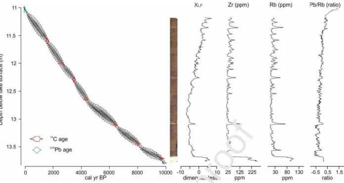
Figure 3. Age-depth model for Popradské pleso constructed using 210Pb (light blue line near modern) and 7 14C radiocarbon dates (shown in red) using ‘BACON’ (Blaauw and Christen, 2011). The gray area represents the 95th confidence intervals, and the white line delineates the mean probability. High (µm) resolution digital line-scan image of the Pop15-1 core taken using the University of Liverpool Geotek Multi-sensor core logger (MSCL-XZ). Down core profiles for low frequency magnetic susceptibility (XLF), µXRF scan geochemical data for Zr (pmm), Rb (ppm) and Pb/Rb for the long core. Pb/Rb ratio data continues to the modern period using dried
sample XRF measurements.
Journal Pre-proof
Figure 4. Reconstructed fire, geochemical, vegetation, and climate at Popradské pleso. From top