University of Szeged
Faculty of Science and Informatics Doctoral School of Geosciences
Department of Economic and Social Geography
EXAMINATION OF THE GEOGRAPHICAL BIAS OF THE HUNGARIAN PARLIAMENTARY ELECTORAL
SYSTEM
The theses of Doctoral (Ph.D.) dissertation
György Vida
Supervisor:
Prof. Dr. Zoltán Kovács
member of the Hungarian Academy of Sciences, head of department
Szeged 2020
1 I. Research topic and theoretical backround
In modern democracies it is a vital issue how different electoral systems convert the votes cast by the voters to parliamentary seats. The effects of geography on political representation is of high importance especially in those countries where the votes are cast within some territorial framework which is especially the case in majority based or mixed electoral systems.
The relevance of this Ph.D. dissertation is that in the mixed electoral system having been applied in Hungary since the change of regime, the number of the voters in the constituencies has shown great inequalities. This inequality has further grown due to demographic changes, therefore, the correction of the electoral system became necessary. The Act on the election of the Members of the Parliament (Act CCIII.) was enacted in 2011 whereas the Act on the electoral procedure (Act XXXVI.) was enacted in 2013. The new law transformed the framework of the elections and reduced the number of MPs from 386 to 199. The changes have involved the reduction of the number of individual constituencies from 176 to 106 and the complete rearrangement of the borders. In the new electoral system, two parliamentary elections have been held, therefore, the effects of the geographical factors on the allocation of mandates in the previous and the present electoral system became comparable.
Since the size and shape of constituencies has great influence on gaining mandates (MARTIS, K.C. 2008) the analysis of the electoral systems’
locational effects (ERIKSON,S.R. 1972, JOHNSTON,R.2002a,b,2015) has been high on the agenda of political geography for a long time (LEIB,J.– QUINTON,N. 2011). The international literature focusing on the geographical bias of electoral systems is very rich, although most of the researches have analysed majority-based systems and have dealt with Anglo-Saxon case- studies (LEIB,J.–QUINTON,N. 2011). Concerning the Hungarian literature, electoral geographical studies have been carried out after the change of regime (HAJDÚ Z. 1992, 2006), which have mostly dealt with the spatial patterns and continuity of voters’ participation and the support for political parties (KOVÁCS Z. 1993, 2000, 2001, KOVÁCS,Z.–DINGSDALE,A. 1998, RÁCZ B.–KUKORELLI I.1995). Moreover, papers have also dealt with the background factors influencing the geographical results of elections (HEGEDŰS G. 2007, SZABÓ B.–TÁTRAI P. 2011, 2016). Nevertheless, the analysis of the geographical influencing factors is still in its infancy. In addition, this PhD research has also practical importance as decision makers have to pay attention to the long-term demographic and social processes when defining the boundaries of constituencies.
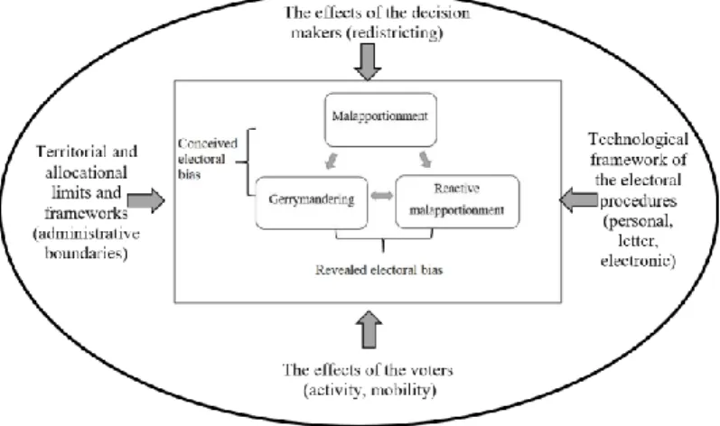
I. The conceptual issues of the geographical bias of the electoral systems
Before formulating the main questions of research, it is important to clarify the conceptual framework of the geographical factors influencing the functioning of electoral systems. As catch all term, I define territorial processes resulting in unequal political representations ‘geographical bias’.
Based on the literature factors causing geographical bias can be divided into three groups. One of them is malapportionment (GROFMAN,B.et al.1997), which means the uneven distribution of people entitled to vote and its correlation with the support of different parties taking part in the elections.
On the day of the elections malapportionment is also modified by the territorial differences of the participation and the valid votes cast, seriously influencing the allocation of mandates. This pehnomenon is defined as reactive malapportionment factor by the literature (JOHNSTON,R.2002a,b, 2015). Finally, the concept of gerrymandering includes all those phenomena which modify the territorial dispersion of the political parties’ support by transforming the borders of the constituencies (MORILL,R. 2009). According to this research in Hungary homogenized and mixed constituency types can also be shown. As for my studies, due to the different electoral and party system, the international theoretical framework can only be partially used for Hungary, however, its adaption is of crucial importance. During my research I set up a model which can be applied for Hungary (Figure 1.)
Figure 1. The model of the geographical factors influencing electoral systems
Source: Own elaboration
3 According to my research findings, my theoretical statement is that besides the static causal interpretation of the geographical factors, it is the interactions between the elements which really influence the nature of electoral bias. As a result, the aim of this dissertation is to examine the geographical bias of the Hungarian electoral system, both before 2011 and after.
II. The research questions
During my research primarily I wanted to answer the following question:
what type of electoral bias did characterize the Hungarian electoral system between 2002 and 2018? In order to answer this main research question, I have had several partial questions to be answered. Thus, in the dissertation I have also asked numerous sub-questions, as well.
What are the connections among malapportionment, gerrymndering and reactive malapportionment?
After 2002 at the level of constituencies how has the geographical pattern of electoral support of the parties getting into the parliament changed?
What was the role of malapportionment after the turn of the millenium concerning the demarcation of the Hungarian constituencies?
How was the effect of malapportionment modified by the participation and the territorial differences of the votes not being taken into consideration when counting the mandates?
What was the extent of gerrymandering in the Hungarian electoral system following the turn of the millenium?
By answering the research questions the rate of the electoral bias of the Hungarian parliamentary electoral system and its effects on the parties’
mandate can be learnt. Based on my researches analyzing the results of the parliamentary elections taking place between 2002 and 2018, I have also come up with some recommendations for policy-makers. On the one hand, I highlight those distorting factors which result in inequal political representation. On the other hand, I also figure out those factors which will have to be taken into consideration in the future when planning the boundaries of the parliamentary individual constituencies. In this respect the dissertation also serves practical purposes since if we take the background demographical and social processes into consideration during the demarcation of the constituencies, in the future a more unbiased division can be realised.
IV. Applied research methods
The set research questions and the geographical scale and longitudinal approach required the application of quantitative methods. During the research I have used data sets of the parliamentary elections taking place between 2002 and 2018. Besides this, in order to define the demographic and social factors affecting the electoral bias, it was necessary to use settlement and constituency level social statistics as well. I have acquired these from the database of the Hungarian Central Statistical Office, the National Election Office and the National Regional Development and Information System (TEIR). Besides the data needed for the analysis, I have also prepared the base maps of the previous and current constituencies.
After finishing the data collection and drawing the electoral maps, I have completed several mathematical and statistical calculations in order to reveal the geographical bias of the Hungarian electoral system. As a first step, I have made an international comparison with the use of the Loosemore-Hanby and the Gallagher indices calculating the rate of votes per mandate showing the general disproportion of the Hungarian electoral system. Afterwards I analysed the impacts of geographical factors with descriptive statistics (mean, median, spread, dispersion) of the constituencies’ data.
Besides defining the electoral geographical fragmentation, I have primarily used Pearson’s correlations, Spearman’s rank correlations and linear regression to reveal the electoral bias and the social breaklines. I have examined the phenomenon of gerrymandering with the equality of the parties votes’ spatial distribution which I have analyzed with various regional analytical methods. I have analyzed the differences of the results of the 2002- 2018 parliamentary electons with Hoover-indices and with unweighted and weighted Gini-indices at the level of constituencies and settlements.
Moreover, I have also calculated the Herfindhal-Hirschman indices to measure concentration of votes by considering the division of the constituencies, and by applying weighted relative standard deviation. Doing so, I could check the trends by applying different methods. In order to figure out the country’s constituency level political fragmentation between 2002 and 2018, I have applied hierarchical and K-mean cluster analysis where the income data set was formed by the listed results of the parties getting into the parliament.
Since, besides the difficulty of choosing the suitable indicators, the chosen territorial scale also influences the results, I have used further statistical methods, as well. In order to interpret the settlement level neighbourhoods covered by the constituencies, I have calculated Anselin Local Moran’s and Getis Ord’s local area auto correlation and also to reveal
5 cautional correlations I have calculated geographically weighted regression. I have carried out the mathematical and statistical analyses with the help of Microsoft Excel and IBM SPSS 22, 23 and 24 programs and I have used ArcMap 10.3 and Mapinfo Professional 10.0 software programs for drawing and modifying the base maps.
V. The thesis like summary of the research results
The objective of my Ph.D. dissertation was twofold. On the one hand, I wanted to study and explain the complexity of the geographical bias present in the Hungarian electoral system. On the other hand, based on the 2002-2018 Hungarian parliamentary elections, I wanted to analyze the extent of geographical bias and also to point out the influencing background demographical and social processes . Based on my research, I can formulate the following five theses.
The mandate allocation efficiency of the Hungarian electoral system is largely influenced by geographical distortions causing inequal political representations
It can be stated that between 2002 and 2010 in the previous electoral system the constituency level territorial dispersion of voters did not show significant correlation with either of the parties’ list. Considering the support of the parties weighted with participation, I found that the smaller parties showed weak correlation. Weak positive orientation could be experienced in the case of SZDSZ (Alliance of Free Democrats), MDF (Hungarian Democratic Forum) and LMP (Politics Can Be Different) parties whereas in the case of Jobbik (Movement for a Better Hungary) this correlation was negative. If we further analyse the correlations and subtract the invalid votes and the ones not being considered when counting the mandates, the trend did not change significantly. In the case of the two major parties there were no significant differences between 2002 and 2010, moreover, Jobbik was even favoured by the participation and the geographical dispersion of the useful list votes. However, all the other parties, i.e. the SZDSZ, the MDF and the LMP were disadvantaged by the divison.
When analysing the gerrymandering effects of constituencies, it was the steady concentration of the big parties and the geographical concentration of the medium and small parties that brought successful result. In light of this, in 2002 and 2006 the Hungarian Socialist Party (MSZP) and the SZDSZ were favoured by the previous division whilst the Fidesz–MDF and later the FIDESZ – Hungarian Civic Alliance – Christian Democratic People’s Party
(KDNP) and the MDF suffered a competitive disadvantage. By 2010 the situation changed with the same electoral constituency system, the Fidesz–
KDNP became a beneficiary of the gerrymandering whereas the MSZP, having shrunk to a medium sized party had already suffered moderate disadvantage. By analysing the national results of the Jobbik and LMP the spatial concentration of their voters seemed fairly positive then. However when the constituencies were transformed (in 2011), the values and the dimension of gerrymandering also changed.
Compared to the previous situation, I found diverse correlations in the constituency system established by the new election law in 2011. In the light of the 2014 and 2018 election results it can be stated that the constituency level territorial dispersion of people entitled to vote had significant correlation with the list of the Fidesz–KDNP and the negative value indicated that this factor was favourable for the alliance. We can also clearly say that in the case of the other parties there was no such correlation. The fact that between 2014 and 2018 the rate of negative correlation between the Fidesz–
KDNP votes and the ones entitled to vote decreased, showed that demographic changes also influenced this factor.
It has also been confirmed by the results that while the previous division affected significantly only the efficiency of the smaller parties, the inequalities of the new territorial division supported the Fidesz–KDNP party alliance with moderate correlation. If we weight the differences of the current divison of constituencies with participation rates, a considerable inequality can be seen in the new electoral system. On the one hand, in the case of the Fidesz–KDNP alliance the favourable factors intensified since they performed better in those constituencies where voters showed lower rate of activity and performed more badly where voters showed higher participation rate. On the other hand, after the weighting of the simple territorial disproportion it can be observed that the neutrality of the system vanishes, and the negative impact on all the opposition parties becomes prevalent.
While the Jobbik was supported slightly positively by the new subdivision, parties belonging to the left-liberal side were affected negatively by the new system, the rate of which decreased between 2014 and 2018. Furthermore, by 2014 in the new electoral system, the transformed division of constituencies also affected gerrymandering. Compared to the 2010 parliamentary election results, in 2014 the opposition parties could improve their results although their voters showed even bigger concentration than previously. In that political environment it was an advantage since they could obtain more mandates, for example in Budapest, Miskolc and Szeged. However, in a sharper competition the left-liberal parties would have performed worse than four years earlier, due to their high spatial concentration.
7 Until 2018 despite the rearrangement of the national politics and the opposition ballots, real changes did not occur in this process. During the 2018 elections tactical voting was again an advantage for the medium and small parties. The LMP but mostly the MSZP – PM (Dialogue for Hungary) and the DK (Democratic Coalition) could gain more individual mandates due to the significant concentration of their voters, whereas in case of the Jobbik the more even distribution was rather a disadvantage. It can be stated that from the perspective of gaining mandates, currently the constituency level vote allocation of the Fidesz–KDNP is the most effective although a possible growth of the opposition votes may change it in the future.
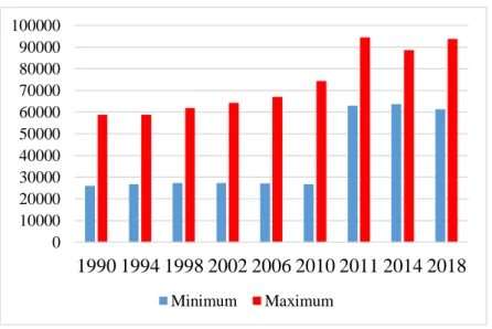
Constrains of the county boundaries and effects of demographic transition need to be taken into account when redrawing the boundaries of individual parliamentary constituencies.
This research found that big differences in terms of size existed even in the first constituency division which grew further from the end of the 1990’s, seriously challenging the principle of equal vote (Figure 2.).
Figure 2. The maximum and minimum number of voters in Hungarian constituencies between 1990 and 2018
Source: based on the data of the Hungarian Central Statistical Office and the National Electoral Office – own calculation and design
0 10000 20000 30000 40000 50000 60000 70000 80000 90000 100000
1990 1994 1998 2002 2006 2010 2011 2014 2018
Minimum Maximum
After the turn of millenium the difference between the smallest and largest electoral districts grew dynamically. In 2002 the value of the ratio was 2,35, in 2006 it was 2,48 whereas in 2010 it was already 2,78. That was the reason why the revision of the constituencies became necessary. During the new demarcation of constituency boundaries in 2011, it was a big problem that the border of the counties could not be crossed by any constituencies. Thus, in rural, peripheral areas small individual constituencies caused a problem, while in the suburban areas surrounding Budapest and the major cities, the growing concentration of the population, and oversize constituencies generated problems. Due to the new constituency division in 2011, the size differences have clearly decreased, the largest constituency was one and a half times bigger than the smallest. It had even reduced by the 2014 elections when the quotient of the maximum and the minimum was 1,39 and later in 2018 it started to grow again and exceeded the one and a half threshold (1,53). The difference from the national average became also more moderate in the case of the majority of the constituencies which shows that the differences of the voters’ territorial distribution could partly be reduced.
According to research results territorial differences of demographic and mobility processes were not taken into consideration properly when drawing the boundaries of new constituencies.
After 2011, the number of adult population has considerably grown around Budapest also further away which indicated the attractiveness of the economy of Budapest and the process of suburbanization. Among the major regional centers, Pécs has fallen back in terms of population, Győr and Székesfehérvár have remained dynamic and recently the concentration of the adult population has also commenced in the region of Szeged. Besides, between 2012 and 2018 a dynamic growth could be experienced in Győr- Moson-Sopron and Vas counties (i.e. Western Hungary) and in the areas along the border of Szabolcs-Szatmár-Bereg county. While in case of the the first two counties, the reason of population dynamism was the east-west internal migration, the latter was caused by the mass in-migration from Transcarpathia. Therefore, the basic rules for the territorial balance of voters set by law were not met even in 2018 (Figure 3.) As a consequence, as expected, by the 2018 parliamentary elections ten constituencies exceeded the 15% threshold morever two even exceeded the 20% intervention limit which even then should have forced the parliament to make changes.
9 Figure 3. The percentage of those entitled to vote compared to the national
average in the 106 individual constituencies based on the 2018 parliamentary elections
Source:The data of the National Election Office – own calculation and design
If we take recent demographic trends into consideration, this situation is going to worsen in the near future since in the agglomeration of Budapest, a further growth of the population can be expected while in the peripheral areas its opposite is most probable. Thus, in the future the territorial inequality of the population and its temporal trends need to be taken into consideration when drawing the boundaries of electoral districts and by doing so, the number of constituencies delimited within counties will also have to be modified. In Pest and Csongrád county more, whereas in Somogy and Tolna county less constituencies are needed.
When establishing the individual constituencies, the stable spatial inequalities of the electoral participation need to be taken into consideration.
From the research it can be concluded that the geographical dispersion of voters and their division to constituencies define the possible number of votes per seat. However, during elections it is voters’ participation and the
territorial inequalities of the votes that are converted to parliamentary mandates that really matters. Since electoral participation significantly modifies the territorial inequalities of the mandate allocation, its analysis also has a crucial role.
It can be stated that a sense of stability and dynamism can also be observed in the geographical features of the electoral participation. In the dual division system at the level of constituency besides Budapest and its agglomeration in Heves county, in the Transdanubian region and in the compact districts of some county seats the participation is high, whereas in most of the external and internal peripheries, voters’ participation is low.
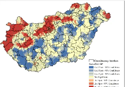
Furthermore, regression calculations confirmed that at the level of the present constituency division, both in 2014 and in 2018 the differences of the social and economic conditions explained the election participation with a value of 70% linearly. Therefore, in the more successful constituencies, the electoral activity is usually higher. Besides, based on settlement level researches, the regional autocorrelation of the voters’ participation during the 2002-2018 parliamentary elections also show which parts of the country have higher electoral participation rates, and which below the national average (Figure 4.)
Figure 4. The Getis-Ord local regional autocorrelation of the voters’
participation during the 2002-2018 parliamentary elections
Source:The data of the National Election Office -own calculation and design
11 In addition to certain exceptions, in Hungary an axis between Sátoraljaújhely and Lenti can be drawn from the time series means of the electoral activity. North of this, voters’ participation is usually higher, whereas south of this lower participation rates can be experienced.
Based on the results, I have come to the following conclusions. In order to fulfil the principle of equal vote, when establishing the boundaries of constituencies, the stable inequalities of voters’ participation also have to be taken into consideration. It is worth forming constituencies even smaller than the average in Budapest and its agglomeration, along the Austrian border, and in Fejér, Heves, Nógrád and Veszprém counties. As opposed to this, south of the axis between Sátoraljaújhely and Lenti, with a few exceptions, less constituencies could be established. Since this aspect has not been considered by the decision makers previously, it can be stated that in the Hungarian electoral system, the differences of voters’ participation exacerbated the already existing inequalities.
The geographical dispersion of the political parties’ support need to be taken into consideration when establishing the parliamentary individual constituencies
Concerning the examined period, the geographical characteristics of the support of the parties with parliamentary representation can be divided into two major groups based on the hierarchical and K-mean cluster analysis. The 2002 and 2006 elections could be described by four, whereas the period between 2010 and 2018 could be described by five typical clusters. The results of the 2002 elections completely changed the previous geographical characteristics of the voting behaviour. A sharp breakline evolved between the right-wing and left-wing blocs in the countryside, whereas in Budapest and its agglomeration the socialists and the liberals possessed strong voter base. Besides, the number of constituencies similar to the national average was also great in 2002. The results of the 2006 parliamentary elections further strengthened the spatial structure of four years earlier, however two changes already indicated the later possible success of the conservative side. The voter base of the Fidesz–KDNP significantly grew in the countryside, and in the traditionally more left-liberal regions, even the MSZP was defeated. The socialists could only reach results above their national average in the declining industrial regions and in Budapest, they became also stronger in rural areas, however, they were not able to acquire new territories. Finally, the significant decrease of the number of constituencies converging to the national average also indicated the widening faultline between the right and the left wing parties.
In 2010 a significant re-arrangement of the spatial pattern of votes could be experienced. In the light of the results of the last three elections, a sort of stability characterized Hungary because of the political predominance of the Fidesz–KDNP and the simultaneously shrinking role of geographical factors.
Nevertheless, if we further analyse regional differences dynamic re- arrangements characterize not only the opposition parties’ votes but also the territorial concentration of the ruling party’s votes. After 2010 in the crisis ridden rural areas traditionally representing the left-wing voting base, the Jobbik has become dominant whilst the MSZP has shrunk. Therefore, between 2010 and 2018, the constituencies could be described by five typical electoral geographical clusters as opposed to the previous four and the re- establishment of the constituency borders did not change it, either. However, the geographical faultlines generated by the economic, social and political processes (mainly the gap between urban and rural areas) strengthened over time, which partly determined the territorial configuration of party identity as well. It can be stated that this new constituency division did not erase but the overconcentrated or mixed demarcation rather caused the steady-state of faultlines around big towns.
When re-drawing the boundaries of parliamentary individual constituencies, the demographic and electoral geographical features of municipalities have to be taken into consideration.
Besides the voters, the spatiality of the parties’ support is also affected by the chosen scale and the constituency division which shows the importance of the geographical aspect. The rate of the geographical distortions often depends on the regional scale of the available data although the extent of the processes is sometimes smaller on the macro-scale than within the constituencies. Therefore, it is also worth analysing the demographic processes, the participation rates and the regional factors of the electoral behaviour at the settlement level. From the settlement level autocorrelations, some conclusions can be drawn concerning the effects of the new boundaries of constituencies; in other words we can point out in which areas were parties’
voters merged and where they were fragment among neighbouring electoral districts. The expected value of the Local Moran index is close to zero and if we get a result significantly different from this, the indicator expresses four possible otcomes. The high-high and the low-low values show territorial concentration whereas the high-low or low-high neighbouring districts are the signs of fragmentation. From the analysis of the list of Fidesz–KDNP it turns out that the differences at the settlement level within constituencies also confirm the role of the borders in the unequal representation (Figure 5.).
13 Figure 5. The settlement level Local Moran autocorrelation of the list voting ratios concerning the Fidesz–KDNP based on the average of the 2010-2018
parliamentary elections
Source:The data of the National Election Office -own calculation and design
In the analysis concentrated and mixed types of gerrymandering can be identified. Mixed constituencies can be observed in Western Transdanubia and in Veszprém county where supporters of opposition parties of the larger cities are merged with rural areas with above-average right-wing supporters in single constituencies. The spatial pattern of the high-low category supports this. As opposed to this, for instance, in the case of the urban regions of Miskolc, Nyíregyháza, Pécs, Szeged and Tatabánya the concentration of high-high types can be observed at the settlement level which, in comparison with the constituency boundaries, basically indicates homogenization. In the case of the Jobbik and LMP such significant pattern and difference could not be experienced within the constituency boundaries. It is important to emphasize that political representation is dynamically formed by the voters and the spatial pattern countinuously changes over time. Therefore, the demographical and mobility processes taking place in the rural and urban areas also have to be taken into consideration when drawing the boundaries of constituencies so that the principle of equal voting should not be violated.
VI. The possibilities of the practical utilization of research results
Based on my Ph.D. research it can be stated that a new electoral re- districting and a new constituency division is needed in Hungary. In the future, decision makers will have to consider certain factors when creating the constituencies, if they want a more fair and more effective mandate allocation. Recommendations stemming form the research can be listed as follows:
In order to keep control over the geographical bias of the Hungarian electoral system and to revise the constituencies from time to time, a professional committee need to be set up which checks the criteria set by the law.
The electoral law and the definition of the core principles must remain a two-third majority act, however the division of the electoral constituencies should be decided by simple parliamentary majority.
In Hungary when forming the boundaries of constituencies, the most important aspects is the consistent application of the one man, one vote principle. Besides, the constituencies must be coherent areas.
Based on international experiences, during the establishment of the constituencies, the rate of discrepancy from the national average should be reduced from 15-20 percent to 10-15 percent.
After each census, the inequalities among the constituencies must be reconsidered on each and every occasion and if necessary, the boundaries must be modified.
When drawing the constituency boundaries, the demographic processes (fertility, mortality, internal and external migration, suburbanization, etc.) must be taken seriously into consideration since by doing so, more durable division can be achieved.
The role of voters’ participation must be considered so that the areas with higher activity rates should be more considered in the re-districting process than constituencies with less voters and not the other way round.
The technical circumstances of voting in the case of citizens living abroad need to be dealt with in the future (electronic voting through a customer portal, etc.) since it also affects mandate allocation.
Similarly to the international practice, it is necessary to set up a professional committee involving experts from different field for the sake of objective re-districting, who may control the principles enshrined in the law and accordingly who make proposals for amendments.
15 To sum up, the constant analysis and the reduction of the inequalities parliamentary individual constituencies may have several practical relevance.
On the one hand, a division considering the demographic, social and electoral geographical processes of the constituencies can be more durable in time, therefore the subsequent amendments may have less political and administrative burdens. On the other hand, it would be in accordance with the frameworks and criteria set out by the electoral law, thus, the principle of equal voting would be less violated. Furthermore, if we reduced the geographical bias of the electoral system, the representation would also be more fair which would more accurately reflect the political will of the electorate. Consequently, the confidence of people in the political institutions would also be higher which may contribute to the active involvement of voters in public affairs.
VII. Possible further directions of research
The research topic of the dissertation has further theoretical and methodological potentials. Concerning the theoretical interpretation of the
“one man one vote principle, the survey of further factors which influence mandate allocational bias can be important depending on the electoral system (e.g. preferential voting, campaign strategies).The explanation of these factors and their effects in different sample areas could shed light on the extent of distortions. In addition, further methodological considerations should include the refining of the calculation and the mapping of the geographical effects which may help the analysis by involving and modelling constituency data in urban areas. Furthermore, the analysis of the complex dynamic interrelations of the electoral bias drafted in the dissertation, after appropriate adaptation, could also be extended to the electoral system of the surrounding post-social countries.
Concerning Hungarian electoral geography, it is very difficult to create the right terms in Hungarian language expressing the different aspects of electoral bias, which raises serious terminological questions and may give rise to a broader scientific discourse. However, from the aspect of longitudinal measurement, repeating the analysis following the 2022 and 2026 parliamentary elections, it could provide an opportunity to track changes in distortions over longer period of time. Finally, since the contemporary allocation of seats, the differences concerning the size of the constituencies violate again the law, the electoral districts should be re- designed soon. In this case, the impact of the decision makers on the electoral system could be examined again which may lead to a more professional re- districting system and more durable constituencies in Hungary.
VIII. Publications on the topic of the dissertation MTMT identification number: 10038487
1. VIDA GY. 2014: WARF,B. and LEIB,J. (ed.): Revitalizing Electoral Geography. – Hungarian Geographical Bulletin. 63.4. pp. 462-464.
2. KOVÁCS Z.–VIDA GY. 2015: Geography of the new electoral system and changing voting patterns in Hungary. –Acta Geobalcanica. 1.2.
pp. 55-64.
3. VIDA GY. – KOVÁCS Z. 2015: A magyar választási rendszer területi aránytalanságai 2011 előtt és után. –Területfejlesztés és Innováció.
9.1. pp 2-10.
4. VIDA GY. 2016: Az egyenlőtlen politikai reprezentációt létrehozó választási földrajzi hatótényezők mérési lehetőségei. – Területi Statisztika. 56.6. pp. 643-659.
5. VIDA GY. – DUDÁS G. 2017: Geographical context of the revealed competitiveness of urbanised areas in Hungary excluding the Budapest agglomeration. – Geographica Pannonica. 21.3. pp. 179- 190.
6. VIDA GY. – KOVÁCS Z. 2017: Magyarország átalakuló választási földrajza a 2010-es és a 2014-es parlamenti választások tükrében. – Földrajzi Közlemények. 141.2. pp. 125-138.
7. KOVÁCS Z.–VIDA GY. 2018: Malapportionment and gerrymandering in post-socialism: the Hungarian context. – In: PÉNZES J. (szerk.): Falu - város - periféria: határon innen és túl: Süli-Zakar István professzor emlékére. Didakt Kiadó, Debrecen. pp. 161-166.
8. VIDA GY.–KOVALCSIK T. 2018: Magyarország választási földrajzi sajátosságai a 2014-es és a 2018-as parlamenti választások tükrében.
– Modern Geográfia. 13.4. pp. 15-30.
Other publications:
9. VIDA GY. 2016: A vidéki agglomerációk, agglomerálódó térségek és nagyvárosi településegyüttesek versenyképességének sajátosságai. In: LENGYEL I. – NAGY B. (szerk.): Térségek versenyképessége, intelligens szakosodása és újraiparosodása.
JATEPress Kiadó, Szeged. pp. 204-222.
10. DUDÁS G.–VIDA GY.–KOVALCSIK T.–BOROS L. 2017: A socio- economic analysis of Airbnb in New York City. – Regional Statistics. 7.1. pp. 135-151.