The original published PDF available in this website:
https://www.sciencedirect.com/science/article/pii/S1040618215300392?via%3Dihub
Quaternary International 477 (2018) 94–105
Holocene fire-regime changes near the treeline in the Retezat Mts. (Southern Carpathians, Romania)
Walter Finsingera,*, Jordan Fevrea, Ildikó Orbánb, Ilona Pálc,d, Ildikó Vinczec,d, Katalin Hubaye, Hilary H. Birksb, Mihály Braune, Mónika Tóthf, Enikő K. Magyaric
aPalaeoecology, ISEM UMR 5554 CNRS/UM/IRD/EPHE, Place E. Bataillon, 34095 Montpellier, France
bDepartment of Biology, University of Bergen, PO Box 7803, N-5020 Bergen, Norway
cMTA-MTM-ELTE Research Group for Paleontology, H-1117 Budapest, Pázmány Péter st.
1/C, Hungary
dDepartment of Physical and Applied Geology, Eötvös Loránd University, H-1117 Budapest, Pázmány Péter st. 1/C, Hungary
eHungarian Academy of Science e Institute for Nuclear Research, Hertelendi Laboratory of Environmental Studies, H-4026 Debrecen, Bem tér 18/C, Hungary
fBalaton Limnological Institute, MTA Centre for Ecological Research, H-8237 Tihany, Klebelsberg Kuno st. 3, Hungary
*Corresponding author:
E-mail address: walter.finsinger@univ-montp2.fr (W. Finsinger).
Abstract
To investigate Holocene vegetation and fire-disturbance histories in the treeline ecotone, macroscopic charcoal, plant-macrofossil, and pollen records from two lacustrine sediment records were used. Lake Lia is on the southern slope and Lake Brazi is on the northern slope of the west-east-oriented Retezat Mountain range in the Romanian Carpathians. The records were used to reconstruct Holocene fire-return intervals (FRIs) and biomass burning changes.
Biomass burning was highest at both study sites during the drier and warmer early Holocene, suggesting that climate largely controlled fire occurrence. Fuel load also influenced the fire regime as shown by the rapid biomass-burning changes in relation to timberline shifts.
Overall, the number of inferred fire episodes was smaller on the northern than on the southern slope. FRIs were also comparatively longer (1000–4000 years) on the northern slope where Picea abies-dominated woodlands persisted around Lake Brazi throughout the Holocene. On the southern slope, where Pinus mugo was more abundant around Lake Lia, FRIs were significantly shorter (80e1650 years). A period of frequent fire episodes occurred around 1900–1300 cal yr BP on the southern slope, when chironomid-inferred summer temperatures increased and the pollen record documents increased anthropogenic activity near the treeline.
However, the forest clearance by burning to increase grazing land was subdued in comparison to other European regions.
Keywords
Fire history; Treeline; Holocene; Carpathians; Plant macrofossils
1. Introduction
Understanding the factors that influence the natural variability of disturbance regimes is important for ecosystem conservation and restoration purposes. In European mountain regions, fire is increasingly acknowledged as a natural agent of disturbance. However, the higher disturbance frequency predicted for the next century in high-elevation ecosystems (Wastl et al., 2012) may pose new challenges to fire management in Europe (Valese et al., 2014). Two main factors make fire an increasingly relevant ecological factor in European mountain ecosystems. Timberlines (i.e. the line delimiting closed forests) that were shifted downslope by the creation of summer pastures and meadows for intensified grazing activities (Baur et al., 2007; Tinner, 2007) are predicted to shift upwards again due to abandonment of agricultural practices in economically marginal areas and the effects of climate warming on the treeline ecotone (Gehrig-Fasel et al., 2007; Schwörer et al., 2014). The resulting higher forest connectivity and biomass availability (fuel) in the future treeline ecotone will facilitate the spread of fires. Secondly, the potentially higher frequency of exceptional droughts due to climate change in some areas (e.g. Southern and Central Europe) (Schär et al., 2004) may increase the frequency of favourable weather conditions for fire ignition and spread.
Vegetation responses to environmental changes are extremely complex, and this complexity may be more striking due to interactions between vegetation composition and environmental conditions such as climate and fire-disturbance regimes (Gavin et al., 2006; Higuera et al., 2009). Although climatic factors are generally considered to be the predominant driver of fire regimes (Daniau et al., 2012), vegetation composition and woodland cover can modulate the effects of climate by controlling the type and structure of fuel available for combustion (Higuera et al., 2009; Gil-Romera et al., 2014). Palaeoecological records allow short-term instrumental and documentary records to be extended back over several millennia and make it possible to investigate the natural variability of fire regimes, the human dimension of fire
regimes (Bowman et al., 2011), and vegetationefire interactions, through the analysis of pollen, plant macrofossils, and charcoal particles stored in sedimentary archives (Stähli et al., 2006; Morales-Molino et al., 2015).
The Retezat Mountains (Southern Carpathians, Fig. 1) are an interesting area to investigate long-term vegetation fireeclimate interactions. Forest fires are not widespread in the Romanian Carpathians and are considered as a negligible cause of ecosystem disturbances today (Knorn et al., 2013). In keeping with this, previous charcoal records from a high- elevation site in the Southern Carpathians (Lake Brazi: Feurdean et al., 2012; Finsinger et al., 2014), showed that fires were frequent during the drier early Holocene, and that fire activity was less during recent millennia when humans were potentially clearing the treeline ecotone.
This temporal pattern of charcoal records markedly contrasts with the strong biomass-burning increase recorded in the Alps at the Neolithic/Bronze Age transition (about 4000 cal yr BP in the Alpine region), when humans cleared the forest to create summer pastures and meadows and effectively shifted the fire regime outside its natural range of variability (Valese et al., 2014). It also contrasts with charcoal records from the lowland Transylvanian plain where fire frequency markedly increased at about 3000 cal yr BP (Feurdean et al., 2013a). Long- term charcoal records show that fire occurrence can be highly variable both spatially and temporally and that fires are less likely to occur and to spread on more humid northern exposures due to the control of local climatic factors on fuel load and flammability (Whitlock and Larsen, 2001; Carcaillet et al., 2009; Barrett et al., 2013). The Lake Brazi record is located on the northern slope of the range. Hence, it may only be reflecting local fire occurrences on the less fire-prone northern slope of the mountain range.
Therefore, we chose a contrasting site on the southern slope to provide temporal and spatial estimates of past fire-regime variability in the Southern Carpathian treeline ecotone. We present two well-dated multi-proxy (continuous records of macroscopic charcoal, pollen,
stomata, and plant-macrofossils) reconstructions of vegetation and fire history from the Retezat Mountains, covering the past 11,000 years to determine the relationship between local fire regimes and vegetation changes at the treeline ecotone (see also Magyari, Orbán et al., in this issue; and Vincze et al., submitted for publication). We use the macroscopic charcoal record (i) to identify fire episodes and to infer fire-return intervals (FRI, i.e. the time elapsed between two successive fire episodes) using peak-detection analysis (Lynch et al., 2003; Higuera et al., 2009; Finsinger et al., 2014), and (ii) to reconstruct longer-term variations in biomass burning by means of total macrocharcoal accumulation rates (CHAR) that may reflect an integrated signal of charcoal production (depending on burnt area, amount of biomass burnt, and fuel load availability), fire frequency, and deposition and taphonomic processes such as reworking and sediment focusing (Whitlock and Larsen, 2001; Kelly et al., 2013). Because variations in total CHAR depend on the sediment-accumulation rates, we devised a new numerical method to test the influence of modelled sedimentation rates in determining long-term variations of total CHAR. These vegetation and fire proxies, together with a suite of regional climate proxies (Buczkó et al., 2013), including a chironomid-based July-air temperature reconstruction from Lake Brazi (Tóth et al., 2015), enable us to examine vegetation–fire disturbance–climate interactions.
2. Material and methods 2.1. Study area
Due to its inland position, the climate of the Carpathian Mountains arc is classified as temperate-continental. The Retezat Mountains (Romania), being located at the western edge of the strongly dissected southern part of the Carpathian arc, stand out as one of the wettest massifs of the arc, with annual precipitation ranging between 900 and 1800 mm. Mean annual
temperature is around +6 °C in the foothill zone and -2 °C at 2500 m asl (Bogdan, 2008) and the main wind direction is from W-WNW (Mîndrescu et al., 2010). The vegetation in the Retezat Mountains is dominated by Fagus sylvatica forests in the montane belt (around 800–
1200masl) that are followed up to about 1400masl by mixed forests mainly composed of F.
sylvatica, Abies alba, and Picea abies. These are replaced upslope by a mosaic of conifer forests dominated by P. abies intermixed with Pinus cembra (particularly above 1750 m asl) and Pinus mugo shrublands on exposed cliffs and mires up to the timberline, which is located around 1850–1900masl. The treeline, located around 1950–2000 m asl, is formed by isolated P. abies and P. cembra trees. Above the treeline, subalpine shrublands, with P. mugo, Vaccinium myrtillus, and Juniperus communis give way to alpine meadows. P. mugo and Juniperus are often dominant between 2000 and 2200 m asl (Borza, 1934; Nyárády, 1958;
Csűrős, 1971).
2.2. Study sites
Lake Brazi (Tӑul dintre Brazi: 45°23’47” N; 22°54’06” E) is a small shallow lake (about 0.4 ha; maximum water depth: 1.1 m) located at 1740 m asl in the Gales¸ ului valley, at the north- eastern edge of the Retezat National Park (Fig. 1). It has no inflowing streamand is located about 110m below the present timberline in a mixed conifer forest dominated by P. abies and P. cembra. The lakeshore is covered by a floating Sphagnum moss carpet on which dwarf pine (P. mugo) shrubs are abundant (Magyari et al., 2012).
Lake Lia (Lacul Lia: 45°21’7.2” N; 22°52’36.3” E) is a slightly larger and deeper lake (1.26 ha; maximum water depth: 4.2 m) located at 1910 m asl in the Bucura valley, on the southern slope of the Retezat Mountains (Fig. 1). The lake receives water from two inflow streams, one of them being the outflow of Lake Bucura (2040 m asl). Lake Lia is just below the
current treeline (1930 m asl) and is surrounded by dense P. mugo thickets on the steep rocky western slope and by grazed meadows on its flatter northern shore. The nearest isolated P.
abies trees grow about 100–150 m away and one small sapling 50 cm high grows on the northern shore. However, in nearby valleys on the southern slope of the Retezat Mountains solitary trees may be found up to about 2000 m asl.
2.3. Coring and chronology
Sediment cores from Lake Brazi (6.6 m long) and Lake Lia (8.8 m long) were retrieved using a modified Livingstone piston corer (Walker, 1964) operated from a raft in 2007 and 2008, respectively. The topmost 30 cm of unconsolidated sediment from the Lake Lia could not be retained and were therefore not sampled.
The age–depth relationships for the Holocene sediments of Lake Brazi and Lake Lia were modelled using 21 and 16 14C dates on terrestrial plant macrofossils and on the organic sediment fraction (mostly <250 mm), respectively (for Lake Brazi see Finsinger et al., 2014;
for Lake Lia see Hubay et al., in this issue). To fit an age–depth model we used the smooth spline fitting function in CLAM v2.1 (Blaauw, 2010). The two age-depth models were not extrapolated beyond the lowest 14C dates for the core sections that were analysed in this study. They gave sediment-deposition times less than 40 years cm-1 except in the oldest part of the Lake Brazi sequence (11,260–11,000 cal. BP). This warranted the interpolation of the macro-CHAR record to a temporal resolution of 40 years prior to further numerical analyses (see next sections).
2.4. Loss-on-ignition
Sediment samples of ca. 1 cm3 were dried at 105 °C for 24 h and dry sediment samples (ca.
1–1.5 g) were ignited at 550 °C for 4 h. Percentage loss-on-ignition (LOI) was calculated following Heiri et al. (2001).
2.5. Plant-macrofossil, stomata, and pollen analyses
Sediment subsamples (on average 9 cm3) of Lake Brazi were briefly soaked in 10% NaOH and wet-sieved through 250 μm and 180 μm meshes. Lake Lia sediment subsamples (on average 20 cm3) were soaked in dilute Na4P2O7 if necessary to disaggregate the sediment (high silt content) and sieved through 125-μm mesh. Identifications and counts were made under a stereomicroscope at x 10–40 magnification with the aid of identification keys and by comparison with reference material. Plant-macrofossil accumulation rates (number cm-2 yr-1) were obtained by dividing concentration values (number cm-3) by the sediment-deposition times (yr cm-1) (Bennett and Willis, 2001). The concentrations of plant macrofossil parts identified at taxon level were summed together to estimate population-size changes for P.
mugo, Picea, Juniperus, P. cembra, and Pinaceae as follows: P. mugo =Σ(needles + male cone with anthers + anthers + seeds + seed wings); P. cembra =Σ (needles + anthers + seeds);
Picea abies =Σ(needles + twigs + anthers + seeds + seed wings + female cone scales + male cone scales); Juniperus =Σ(needles + twigs); Pinaceae =Σ(seeds + seedwings + female conescales + budscales + indet. needles + indet. anthers + indet. twigs).
One cm3 sediment subsamples were prepared for pollen analysis in the laboratory using standard methods (Bennett and Willis, 2001), but excluding the acetolysis step. Pollen, spores, and stomata were identified and counted at 400x and 1000x magnification. Pollen was identified with the help of atlases (Reille, 1995, 1992) and identification keys (Moore et al., 1998; Beug, 2004). Pollen percentages were calculated based upon the total sum of terrestrial
pollen grains (>500 for each sample). Stomata were identified and counted on pollen slides (Trautmann, 1953; Sweeney, 2004; Magyari et al., 2012).
In order to detect vegetation changes associated with the creation of pastures, meadows and trampled ground around the study sites, percentages of secondary anthropogenic pollen indicators associated with those habitats (e.g. Plantago lanceolata and Plantago major/media) were summed, following Vincze et al. (submitted for publication).
Plant-macrofossil and stomata records are useful proxies to reconstruct local vegetation changes at the treeline ecotone in Central and South-eastern Europe (Birks and Birks, 2000;
Magyari et al., 2012; Ammann et al., 2014) where conifers and Ericaceae form the main tree and shrub cover. Pollen transported from lower forested elevations into alpine vegetation with low local pollen productivity blurs the pollen records. Nevertheless, pollen percentages are shown in the figures, because plant-macrofossils and pollen are complementary proxies for vegetation change (Finsinger and Tinner, 2007; Jackson et al., 2014).
2.6. Charcoal analyses
We used microscopic charcoal influx as a proxy for regional fire activity and regarded the occurrence of macroscopic charcoal particles as evidence of local fire activity (Whitlock and Larsen, 2001; Conedera et al., 2009). Microcharcoal particles (>10 mm in diameter) were counted on pollen slides with added Lycopodium tablets of known concentration (Stockmarr, 1971) under a transmitted-light microscope following Tinner and Hu (2003) and Finsinger and Tinner (2005). Counts were transformed to influx values (number cm-2 yr-1).
For macrocharcoal analysis, contiguous 1 cm3 subsamples were taken from the upper 550 cm and 440 cm of the Lake Lia and Lake Brazi sediment cores, respectively. Subsamples were deflocculated and bleached using NaOH (10%) and NaOCl (2%), and gently sieved through a
160 μm mesh under a soft water jet (Genries et al., 2012). The residue was carefully washed into a porcelain evaporating-dish to aid identification and counting of charcoal particles against the white background. The material was analysed at x60 magnification under a Leica M80 binocular microscope equipped with a video camera that was connected to an image analyser fitted with Winseedle image-analysis software (Regent Instruments Canada Inc., 2009) that allowed the measurement of total charcoal concentration by number, charcoal areas of individual particles, and the cumulative sum of charcoal-particle areas (i.e. the concentration of charcoal by area).
2.7. Fire-episode reconstructions
For fire-episode reconstructions, macroscopic charcoal concentrations by number and by area were transformed to charcoal-number and charcoal-area accumulation rates (here denoted CHARC: number cm-2 yr-1 and CHARA: mm2 cm-2 yr-1, respectively) by dividing the concentrations with the estimated sample-deposition time (yr cm-1) as inferred from the age- depth models. The CHARC and CHARA records were used to infer local fire episodes in two different CharAnalysis runs (following Finsinger et al., 2014). The records were first interpolated to a constant temporal resolution of 40 years (CHARi) and then broken down into a low-frequency background component (CHARback) and a peak component (CHARpeak) using a robust locally weighted polynomial regression (LOWESS) with a moving-window width of 900 years. This resulted in a robust signal-to-noise index (SNI) (Kelly et al., 2011) and goodness-of-fit between the empirical data and the CHARback data for both the count- and area-based records. The CHARpeak component was evaluated with a Gaussian mixture model that aimed at separating peak samples representing actual fire events from surrounding noise in the CHARpeak series. For each 900-yr window, CHARpeak values exceeding the 99th percentile threshold of the modelled noise distribution were identified as potential fire
episodes (Higuera et al., 2009). Thereafter, identified charcoal-count-based fire peaks were screened with the minimum-count peak-screening test (Gavin et al., 2006; Higuera et al., 2010) and charcoal-area-based peaks were screened with the method proposed by Finsinger et al. (2014). For peak-detection, peak-screening analyses, and local-fire episode reconstructions we used CharAnalysis v1.1 (Higuera et al., 2009) and ARCO v1.0 (Finsinger et al., 2014).
2.8. Change point analyses
To investigate the long-term variations of local biomass burning, we determined the locations of change points (Killick et al., 2012) based on variations of the mean and variance in the CHAR records using the binary segmentation method (Scott and Knott, 1974) in the
‘changepoint’ v1.1.5 package (R Core Development Team, 2012; Killick et al., 2014), following Rius et al. (2014). The binary segmentation is an iterative search method that tests if a change point at position t exists that, at each iteration, separates an ordered sequence of data (y1:n = (y1,…,yn)) into two segments (y1:t = (y1,…,yt), yt+1:n = (yt+1, … ,yn)). At each iteration a change point is retained if a cost function applied to the entire sequence (Ω1:n) is larger than the sum of the cost functions applied separately to the two segments plus a penalty β to guard against overfitting (Ω1:t + Ωt+1:n + b), until no change points that meet this condition are detected (Killick et al., 2012). Here we selected a user-defined penalty (β = 4 log(n)), following Killick et al. (2012). The change-point analysis has some analogy with the sequence-splitting technique (Birks and Gordon, 1985; Birks and Line, 1994).
Because variations in total CHAR may also arise due to variations in estimated sedimentation rates, we devised a new method to test the influence of modelled sedimentation rates in determining long-term variations of total CHAR. The method starts by generating a user-
selected number (here 1000) of random charcoal-concentration records with values ranging between the minimum and maximum value of the charcoal record being analysed. For each randomly generated record, concentrations are then transformed to CHAR using (i) a constant sedimentation rate (CHARrand) and (ii) the sedimentation rate from the age-depth model (CHARsedrate), and both records are then analysed to determine the locations of change points.
In theory, no change points should be detected in the CHARrand series. However, because change points can arise by chance in the randomly generated CHARrand time series, the method retains only those change points that are detected in more than 2.5% of the 1000 runs, effectively screening out the chance change points. Visual inspection of the location of change points in the CHAR records and in the CHARsedrate series may thus reveal the occurrence of change points that are likely to arise from variations in sedimentation rates rather than from changing charcoal abundances alone. The R script is available from the authors on request.
3. Results and interpretation 3.1. Fire-history reconstruction
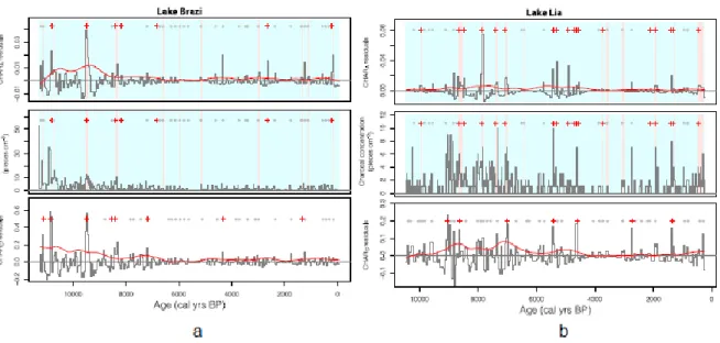
Macroscopic charcoal concentrations ranged between 0 and 10 pieces cm-3 in most of the samples from both sequences (Fig. 2). At Lake Brazi, CHARA and CHARC values were highest in two periods centred on 10,800 and 9200 cal yr BP, then gradually decreased to reach lowest values around 6000 cal yr BP, and thereafter slightly increased to reach a local maximum at 500 cal yr BP (Fig. 3). At Lake Lia, in contrast, CHARA and CHARC values were highest in three distinct periods: 9000–7500 cal yr BP, 5500–4500 cal yr BP, and 750–
250 cal yr BP (Fig. 3). Generally, macroscopic charcoal concentrations, micro-CHAR, macro-CHARC and macro-CHARA records show similar trends, although in some cases with
different amplitudes (Fig. S1). This is most noticeable in Lake Lia, where macro-CHARA
drops more rapidly at 7800 cal yr BP than macro-CHARC, and between 750 and 250 cal yr BP, where macro-CHARC and micro-CHAR values rise more steeply than macro-CHARA
values.
Based on the peak-detection analysis of the CHARA and CHARC datasets at Lake Brazi (Fig.
2), 7 and 8 distinct fire episodes occurred during the past 11,500 years, respectively. FRIs (Fig. 4a) were lowest (<240 years) at about 8400–8150 cal yr BP and otherwise ranged between 1000 and 4000 years (for more details on Lake Brazi's fire-episode reconstruction see Finsinger et al., 2014). At the south-exposed Lake Lia, 7 and 17 fire episodes were identified based on the CHARC and CHARA datasets, respectively (Fig. 3). The signal-to- noise ratio (SNI) of the CHARC record (Fig. S2) ranged between 2.8 and 9 (median = 3.7) and was smaller than 3.0 between 9000 and 6000 cal yr BP, indicating that it is not suitable for peak-detection analysis (Kelly et al., 2011). The SNI of the CHARA record (Fig. S2) ranged between 2 and 9 (median = 5.7) and was lower than the critical threshold (3.0) only in the most recent part of the record (<500 yr cal BP). FRIs based on CHARA ranged between 80 and 1650 years, with shortest FRIs (mostly <500 years) clustering in three periods: 8450–
7050, 5300–4500, and 1900–1300 cal yr BP (Fig. 4b).
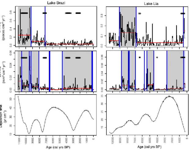
Change points in the randomly generated CHARsedrate series clustered in locations where sediment-accumulation rates rapidly changed (Fig. 3). The change-point analysis for Lake Brazi indicates that total CHARC changed at about 9200 and 7100 cal yr BP. However, the latter change point coincides with change points that occurred also in the randomly generated CHAR record, suggesting that it might have also occurred due to variations of the sediment- accumulation rate. Conversely, the analysis failed to detect change points between the two local maxima centred around 10,800 and 9200 cal yr BP. Nine change points, in contrast, split the CHARA record. Two of them were determined by variations of single (or few)
samples and are therefore not retained further. The CHARA record can be thus subdivided into three phases, with two phases (11,500–8100 and 4700–250 cal yr BP) being characterized by higher values. None of the change points detected in the CHARA record coincided with change points in the randomly generated series. The first period (11,500–8100 cal yr BP) may be further subdivided into four zones, two of which (centred around 10,800 and 9200 cal yr BP) are characterized by higher means.
The change-point analysis for the Lake Lia CHARA records indicates a distinct period marked by higher values (8900–6900 cal yr BP) (Fig. 3). The analysis shows two additional periods with higher CHARA mean and variance (5500–4500 and 2800–250 cal yr BP). Even if the onset of the higher-biomass burning period around 2800 cal yr BP is unsure because the change-point analysis was possibly influenced by the occurrence of one sample having a higher CHARA value (at 2700 cal yr BP), CHARA values were slightly higher after 2000 cal yr BP than between 4500 and 2000 cal yr BP. The rapid CHAR rise at 450 cal yr BP is probably not significant because it coincides with change points that were detected also in the randomly generated CHAR records.
The user-determined penalty value b is largely arbitrary and can greatly influence the results of the change-point analysis (Killick et al., 2012): increasing (decreasing) the penalty value decreases (increases) the number identified segments. This issue is analogous to defining the number of zone boundaries in a multivariate dataset, say a pollen record (Grimm, 1987;
Bennett, 1996). However, the change-point analysis was not used to determine how many change points could be detected within a record but rather to compare the locations of change points in the CHAR and in the randomly generated CHARsedrate records based on the same penalty values. The method effectively suggests that the rapid CHAR increase at 450 cal yr BP in the Lake Lia record is likely influenced by variations in sediment-accumulation rates,
which are related to intensified soil erosion as shown by lower loss-on-ignition values (Fig.
4).
Several peaks initially identified as fire peaks were screened out because they were deemed to be potentially unreliable (Higuera et al., 2010; Finsinger et al., 2014). While the flagged peaks may be related to insignificant variations in the charcoal-abundance estimates, they may also be caused by the occurrence of distant fires (Higuera et al., 2010; Oris et al., 2014) or low-intensity/small area-burnt fires. Modern fire sizes in the Southern Carpathians are small (<750 ha; European Forest Fire Information System (EFFIS)) compared to naturally occurring wildfires in boreal forests that usually burn areas >10,000 ha (Kasischke et al., 2002). Hence, we can expect that several small-area fires were not retained as significant fire episodes with the peak-identification analysis. Regardless, periods of higher biomass burning as revealed by the change-point analysis of the total CHAR record and by low-frequency variations of CHARback records (Figs. 3 and 5) broadly coincide with periods of shorter FRIs, in agreement with the notion that variations in total CHAR can also be influenced by variations of fire-episode frequency (Kelly et al., 2013). Because the pattern is particularly distinct in area-based CHARA records (Fig. 5), the shorter dispersal distances of larger charcoal particles (Clark, 1988; Oris et al., 2014) may be one reason explaining the more distinct variations in those records than in the count-based CHARC records.
3.2. Fireevegetation relationships
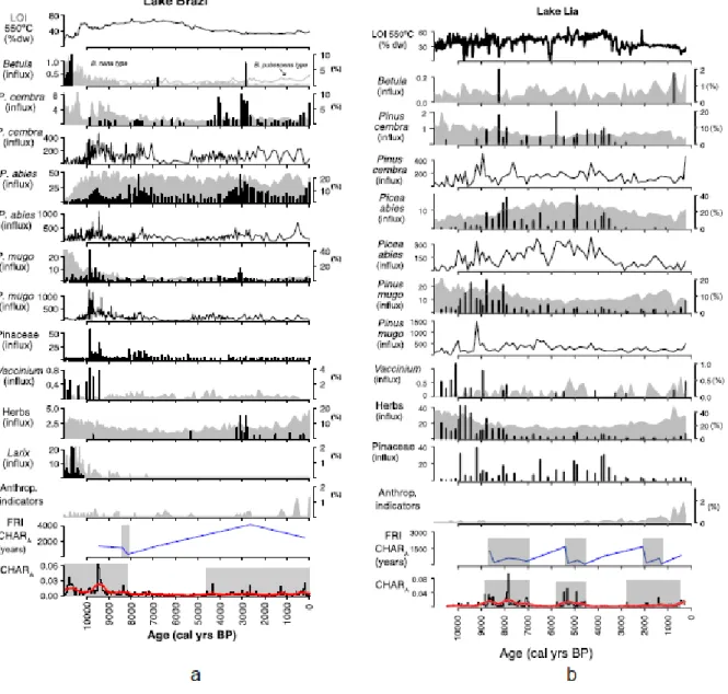
As attested by the abundant plant macrofossils in Lake Brazi (Fig. 4a), the north-exposed lake was always below the timberline for the past 11,000 years. Until about 10,200 cal yr BP, light-demanding pioneer species (Larix, Betula, and P. mugo) were present around the lake together with P. abies and shrubs (Vaccinium). High CHAR and CHARback values attest to
high biomass burning at that time. Thereafter, Larix, Betula, and Vaccinium disappeared locally and P. abies and P. mugo became dominant with scattered P. cembra until about 4500 cal yr BP. P. mugo probably grew locally on the floating bog that developed on the lakeshores, as it does today (Magyari et al., 2011). Under lowest biomass burning conditions (between 8000 and 4500 cal yr BP) local vegetation was dominated by P. abies. Biomass burning moderately increased around 4500 cal yr BP, synchronous with the local expansion of P. cembra and a very small increase in herb pollen percentages. Rising abundances of anthropogenic-pollen indicators suggest that human activities first modified the landscape near Lake Brazi around 3000 cal yr BP and resumed about 1500 cal yr BP onwards (Fig. 4a).
The CHAR record shows that human activities did not substantially alter the fire regime in comparison to the mid-Holocene. However, peaks of anthropogenic pollen indicators coincide with phases of moderately higher biomass burning and with fire-episodes at about 3000 cal yr BP and starting from ~1500 cal yr BP, suggesting that human activities were associated with the use of fire.
Lake Lia was located in the treeline ecotone until about 8000 cal yr BP as attested by the concentrations of P.mugo and P. abies macrofossils and the high abundance of Vaccinium and herbaceous plant macrofossils (Fig. 4b). The stomata record from Lake Lia also supports this interpretation. The high abundance of herbaceous macrofossils until 8000 cal yr BP reflects the large extent of wet habitats. At Lake Lia, P. mugo probably grew on the lakeshore, particularly on the western steep rocky slope. Increasing abundance of P. abies macrofossils, however, indicate that the timberline was gradually creeping up the slope.
Between 9000 and 8000 cal yr BP the density of the forest increased at Lake Lia and the lake remained below the timberline until about 3000 cal yr BP (Orbán et al. this issue). Between 5800 and 3000 cal yr BP, P. abies was co-dominant with P. cembra. Fire activity increased (lower FRIs and higher biomass burning) between 5800 and 4500 cal yr BP. CHAR values
remained overall low between 4500 and 2800 cal yr BP. After about 3000 cal yr BP, loss of tree macrofossils and low values of P. mugo macrofossils suggest that the treeline moved downhill and Lake Lia was situated mainly in the krummholz zone, as also suggested for other sites in the Retezat Mountains (Fӑrcas¸ et al., 1999). Decreasing LOI 550 °C values indicate that soil erosion increased between 4000 and 3000 cal yr BP, when the timberline descended. Short-term increases of CHAR values and robust charcoal peaks allow the identification of local-fire episodes during the past 2800 cal yr BP, i.e. after the soil-erosion increase. Anthropogenic-pollen indicators suggest that human activities modified the vegetation from 2200 cal yr BP onwards around Lake Lia. Concomitantly, FRIs decreased suggesting that some fire episodes were linked to human activities.
4. Discussion
4.1. Spatial differentiation
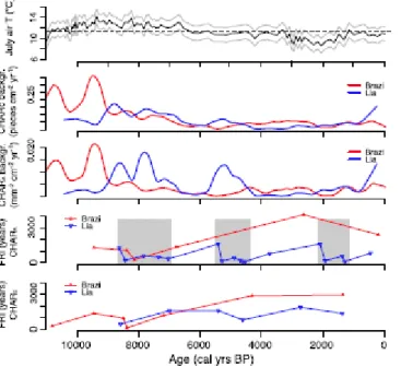
At the treeline ecotone, site history, including climatic changes, wildfire history, and past human impact, play important roles in determining the current sensitivity of the climatic treeline to changing climate (Holtmeier and Broll, 2005). Reconstructed fire regimes on the two opposite slopes of the Southern Carpathians were markedly different (Fig. 5): the number of inferred fire episodes was smaller on the northern than on the southern slope, where periods of higher biomass burning and of more frequent fire episodes (shorter FRIs) occurred during the mid to late Holocene (Fig. 2). In theory, the small distance between the two sites (5 km, Fig.1) does not preclude transport of charcoal particles between the two mountain slopes (Pisaric, 2002; Tinner et al., 2006; Oris et al., 2014). However, the different fire histories of the two sites can be more economically explained by the assumption that the mountain ridge (about 2300 m asl) acted as an efficient barrier to charcoal transport between
the mountain slopes. The situation is similar to that of today, where the southern slope is more fire prone: over the past 10 years fires were smaller and less frequent on the northern than on the southern slopes (mostly no fires or burnt areas <100 ha yr-1 against more frequent fires and burnt areas reaching 750 ha yr-1, respectively (European Forest Fire Information System (EFFIS)). Contrasting spatial patterns of fire regimes have also been reconstructed based on macrocharcoal records elsewhere (Whitlock and Larsen, 2001; Carcaillet et al., 2009; Genries et al., 2012) and highlight the need to increase the spatial density of palaeo- records to reconstruct region-specific spatial patterns of fire-regime changes. The results are therefore consistent with observations that trends and patterns of change can be different for sites situated close to each other (Gavin et al., 2006; Feurdean et al., 2012).
4.2. Drivers of the fire regime
Biomass burning at Lake Brazi and Lake Lia was highest during the early Holocene (Fig. 5) probably because of drier climatic conditions linked to stronger summer insolation, as elsewhere in the Carpathians (Feurdean et al., 2012). The chironomid-inferred July air temperatures (CI-T) record at Lake Brazi (Tóth et al., 2015) closely follows summer insolation changes during the Holocene remaining mostly above present-day temperatures until about 6000 cal yr BP. However, the timing of the early-Holocene biomass-burning maximum was different at Lake Brazi and Lake Lia. Whereas CHAR strongly decreased at Lake Brazi ca. 9200 cal yr BP, at Lake Lia CHAR strongly increased at this time, suggesting that local factors may have been important in driving fire-regime changes. Early spring and growing-season climatic conditions exert a primary control on fire regimes due to their effects on fire ignition and spread and on fuel availability (Körner and Paulsen, 2004;
Schwörer et al., 2014). Similar conditions have been inferred in other palaeoecological records around the treeline ecotone (Gil-Romera et al., 2014).
4.3. Fire history and vegetation changes at Lake Lia and Lake Brazi
The treeline ecotone persisted longer at Lake Lia than at Lake Brazi (until about 8000 cal yr BP) during the early Holocene because Lake Lia is located about 160 m higher, which might result in a mean monthly temperature difference of ~1–1.5 °C using a thermal lapse rate of
~0.6 °C/100 m elevation (Agustí-Panareda and Thompson, 2002) between the two lakes. The lower temperatures at Lake Lia might have advantaged Pinus mugo and Ericaceous shrubs, which are more tolerant against thicker and longer-lasting snow cover than P. abies (Holtmeier, 2009). The rocky surface of a rock glacier on the western shore of Lake Lia (Urdea, 1992) may also have hindered the establishment of P. abies, which requires thicker soils (Henne et al., 2011). In addition, lingering permafrost in the rock glacier after the end of the Younger Dryas may have lowered the local ground temperature (Vespremeanu-Stroe et al., 2012).
However, P. abies, P. cembra and Pinaceae macrofossils were already found from about 10,500 cal yr BP at Lake Lia (Fig. 4), indicating that the treeline ecotone was approaching and that individual trees grew near the lake for about 2000 years before the timberline ascended above it (see also Orbán et al. this issue). Moreover, CI-T (Fig. 5) reached their highest values around 9400 cal yr BP, shortly before the onset of the first high-biomass burning and short FRIs period, and shortly before woody biomass locally increased as suggested by variations of P. abies macrofossil abundances. Taken together, this evidence suggests that frequent fires in the treeline ecotone between 9000 and 8000 cal yr BP could have prevented the closure of the timberline forest and helped to maintain a rather open landscape with abundant herbs and Ericaceae in the treeline ecotone until 8000 cal yr BP, when the P. abies dominated timberline finally ascended above the lake. Higher biomass burning and shorter FRIs starting from about
9200 cal yr BP also coincide with low lake levels at Lake Brazi and at other sites in the Carpathians from around 9000 cal yr BP (Buczkó et al., 2013) suggesting that the climate became relatively dry. Hence, biomass burning before 9000 cal yr BP at Lake Lia may have been low due to the combination of low fuel availability that limited local fire occurrence and moist local climatic conditions. In contrast, the reduced local fire activity around Lake Brazi was probably due to the modulating effect of the dominance of P. abies throughout the Holocene, a species observed to reduce fire activity (Ohlson et al., 2011; Schwörer et al., 2015), and possibly more humid conditions on the northern slope.
Fire activity at Lake Lia remained high until about 7000 cal yr BP probably because fuel availability increased, as attested by the lower abundance of herbaceous macrofossils and increased abundance of P. mugo and P. abies plant macrofossils. High percentages of Corylus pollen, transported from lower elevations, were recorded until about 7400 cal yr BP (Vincze et al., submitted for publication). Corylus is a fire-resistant resprouter (Finsinger et al., 2006) and may suggest that climatic conditions were still sufficiently dry to support high biomass burning in the P. abies dominated timberline forest. Dry climate conditions until about 7000 cal yr BP are also indicated by higher-than present CI-T (Fig. 5) and by low lake- levels at Lake Brazi (Buczkó et al., 2013).
Between ca. 7100–6900 cal yr BP, CI-T decreased in a step-like manner (Fig. 5). Decreasing summer temperatures can well explain the rapid timberline-species descent at 6000–5000 cal yr BP, marked by the local expansion of P. cembra at Lake Lia and later at Lake Brazi. The cooling may have reduced evapotranspiration, thus also reducing fire occurrence at Lake Lia.
The later expansion of P. cembra at Lake Brazi could be explained by the lower elevation of Lake Brazi where the zone of P. cembra occurrence would arrive later as the treeline descended, and the competition provided by the closed P. abies-dominated forests below the
timberline on the northern slope that were less affected by the summer temperature change after 7000 cal yr BP.
Surprisingly, biomass burning increased and FRIs became shorter at Lake Lia between 5500 and 4500 cal yr BP, when CI-T were lower (Fig. 5) and diatoms suggest higher lake levels and/or increasing water turbulence at Lake Brazi (Buczkó et al., 2013) than previously.
Similarly, increasing lake levels and cooler climate conditions, which do not comply with increased fire occurrence, were noted from the Eastern, the Western and from other parts of the Southern Carpathians between 5500 and 4200 cal yr BP (Tóth et al., 2015). An interval characterized by higher charcoal abundance is also visible in other records from the Carpathians located between 1000 and 1400 m asl between 5800 and 4800 cal yr BP (Feurdean et al., 2012). In those records the charcoal abundance increase coincides with the pollen-inferred rapid expansion of Carpinus betulus that may have been favoured by a higher fire activity in the montane belt (Feurdean et al., 2012). However, the biomass-burning increase at Lake Lia was not related to the expansion of C. betulus at lower elevation because the rise of C. betulus pollen percentages already started ca. 1000 years earlier (Vincze et al., submitted for publication). We cannot exclude that charcoal particles were transported from burnt areas located at lower altitudes, as may happen in areas with steep topography (Tinner et al., 2006). Neither archaeological data nor anthropogenic indicators (Cerealia, Secale, or secondary indicators) suggest early livestock grazing during the late Neolithic in the Retezat Mountains (Fig. 4 and Vincze et al., submitted for publication), in contrast to the northern Romanian Carpathians (Feurdean et al., 2016).
4.4. Did anthropogenic fires influence the late-Holocene treeline ecotone vegetation?
The absence of evidence for early human activities and decreasing CI-T around 3000 cal yr BP suggest that decreasing summer temperature caused a downslope timberline shift at Lake Lia. In spite of reduced fuel-availability due to the subsequent dominance of P. mugo shrublands at Lake Lia, fires still occurred. A comparison between Lake Lia's fire record and climate proxies suggests that climatic conditions possibly continued to influence the fire regime: the short-FRI period between 1900 and 1300 cal yr BP at Lake Lia matches well with a period characterized by increasing CI-T (Fig. 5) and by the gradual shallowing and eutrophication of Lake Brazi (Buczkó et al., 2013); likewise, higher lake level at Lake Brazi between 3010 and 2800 cal yr BP coincides with decreased fire activity. Yet, the CI-T and the diatom-inferred water-depth reconstructions may be influenced by anthropogenic nutrient enrichment, casting doubt on the climate–fire relationship.
Fires can have a significant and long-lasting impact on vegetation structure and composition by disfavouring fire-sensitive species and by promoting open spaces and fire-resistant species (Stähli et al., 2006; Leys et al., 2014b; Schwörer et al., 2015). Short FRIs, ranging between 80 and 560 years fire-1, occurred between 1900 and 1300 cal yr BP at Lake Lia. The increase of secondary anthropogenic-pollen indicators (mainly P. lanceolata) from ca. 2000 cal yr BP at Lake Lia (Fig. 4) suggests that anthropogenic disturbance could also have contributed to the increase in fire activity through intentional burning of the P. mugo shrublands to open the landscape further for summer pastures and meadows. These short FRI estimates are in broad agreement with records from the Alps, where P. mugo has been observed to be resistant to, and possibly even favoured by, the occurrence of fires with FRIs of ca. 250 years (Stähli et al., 2006) and 30e735 years fire-1 (Leys et al., 2014a). Such low FRIs also comply with the qualitative assessment of the flammability of P. mugo, which was rated as “producing fires that likely present significant control problems requiring effort and resources”
(Xanthopoulous et al., 2012).
Warming climate, as shown by increasing CI-T (Fig. 5), might have favoured high-altitude pastoral activities as also suggested for the Rodna Mountains (Geanta et al., 2014), Apuseni Mountains (Feurdean et al., 2009) and the Alps (Tinner et al., 2003). Human activities (pastoralism, clearance, burning) may have prevented the timberline from rising naturally in the warmer conditions. The rapid increase of anthropogenic-pollen indicators together with decreasing pollen abundances of P. mugo and P. cembra around 700 cal yr BP at Lake Lia suggests that the local tree and shrub cover was opened by more intensive pastoral activity during the Middle Ages, when anthropogenic land-cover change involved greater clearance of the mountain-pine thickets to obtain new pastures (Solár and Janiga, 2013). The absence of detected fire-episodes from 700 cal yr BP onwards at Lake Lia may thus be the result of reduced fuels due to livestock grazing that effectively suppressed fire occurrence (Bowman et al., 2011) by thinning the P. mugo shrublands for grassland. At Lake Brazi, in contrast, discontinuous occurrence of anthropogenic-indicator pollen (Fig. 4) since 2600 cal yr BP suggests that human activities were less extensive in the P. abies dominated forest below the timberline than on the southern slope. Nevertheless, distinct anthropogenic-indicator pollen peaks coincide with charcoal peaks (some of which were identified as fire episodes) supporting the notion that pulses of anthropogenic land-cover change alternated with rapid forest regeneration (Tinner et al., 2003; Finsinger and Tinner, 2006; Feurdean et al., 2013b).
4.5. Comparison with other central European regions
The fire history in the Southern Carpathian treeline ecotone differs from the lowland Transylvanian plain and elsewhere in Europe, where a distinct shift from natural to “human fire regimes” has been detected at the Neolithic/Bronze Age transition (Tinner et al., 1999;
Feurdean et al., 2012; Molinari et al., 2013; Morales-Molino and García-Antón, 2014). In those regions, late-Holocene biomass burning, as inferred from CHAR records and from FRI
reconstructions, markedly exceeded the mid-Holocene range of variability, often leading to substantial changes in vegetation composition and sometimes to the local extinction of fire- sensitive species (Tinner et al., 2000; Rey et al., 2013; Morales-Molino et al., 2015). The comparatively low late-Holocene fire activity (Fig. 5) and the late appearance of anthropogenic-pollen indicators in the Retezat Mountains suggest that prehistoric cultures exploited the marginal high-mountain pastures less intensively than in the Alps.
Since the Middle Ages, more intensive land-use of subalpine pastures led to a drastic thinning and/or reduction of P. mugo thickets throughout the Carpathians (Nedelea and Comӑnescu, 2009), thereby indirectly suppressing fire occurrence. Over the past ca. 50 years, and more so after the demise of the social system in the 90's, pastoral activities have strongly decreased in several sectors of the Carpathians causing the re-expansion of P. mugo in the alpine treeline ecotone (Tsaryk et al., 2006; Nedelea and Comӑnescu, 2009; Solár and Janiga, 2013). The increasing biomass availability, together with the potential effect of more frequent heat waves in Central Europe in the coming decades (Schär et al., 2004), may thus lead to increased fire risk in the high elevation mountain environments of the Carpathians. However, how fire risk will develop in the mountain-pine thickets of the Carpathians will largely depend on the amplitude and nature of climate change, on the vegetation changes associated with the climate changes, and on land-use management.
5. Conclusions
This study provides the first long-term fire-episode reconstruction related to treeline variability in the Retezat Mountains and adds a valuable perspective on the impact of climate and land-use changes on high-altitude vegetation in European mountain regions. Results suggest that highest biomass burning occurred during the warmer and drier early Holocene,
when the treeline was rising towards its highest elevation. Fire frequency spatially reflected the different microclimates of the north and south slopes and the positions of the sites in relation to the treeline ecotone. Anthropogenic vegetation change increased during the past ca. 2000 years, especially on the south slope, and is related to a moderate biomass burning increase until ca. 1300 cal yr BP. Thereafter, more intensive land-use activities in the high- mountain areas led to the indirect suppression of local-fire occurrence due to the thinning and/or cutting of P. mugo thickets (fuel suppression) around the treeline. With the on-going land-abandonment in economically marginal areas, such as those at the treeline ecotone, the natural reforestation by P. mugo thickets may potentially lead to moderately higher fire occurrences.
Acknowledgements
Data of recent forest fires were provided by the European Forest Fire Information System e EFFIS (http://effis.jrc.ec.europa.eu) of the European Commission Joint Research Centre. This study was supported by the French ANR (OBRESOC project; ANR-09-CEP-004- 01/OBRESOC), the Hungarian Scientific Research Fund (PROLONG project; OTKA NF101362), and by an STSM grant to IV by the EUCOST Action INTIMATE (ES0907). We thank the support of the Retezat National Park. We are also grateful for the constructive suggestions from three reviewers.
Appendix A. Supplementary data related to this article can be found at http://dx.doi.org/10.1016/j.quaint.2016.04.029.
References
Agustí-Panareda, A., Thompson, R., 2002. Reconstructing air temperature at eleven remote alpine and arctic lakes in Europe from 1781 to 1997 AD. Journal of Paleolimnology 28, 7–23.
Ammann, B., van der Knaap, W.O., Lang, G., Gaillard, M.-J., Kaltenrieder, P., Rösch, M., Finsinger, W.,Wright, H.E., Tinner, W., 2014. The potential of stomata analysis in conifers to estimate presence of conifer trees: examples from the Alps. Vegetation History and Archaeobotany 23, 249e264. http://dx.doi.org/10.1007/s00334-014-0431-9.
Barrett, C.M., Kelly, R., Higuera, P.E., Hu, F.S., 2013. Climatic and land cover influences on the spatiotemporal dynamics of Holocene boreal fire regimes. Ecology 94, 389–402.
Baur, B., Cremene, C., Groza, G., Schileyko, A., Baur, A., Erhardt, A., 2007. Intensified grazing affects endemic plant and gastropod diversity in alpine grasslands of the Southern Carpathian Mountains (Romania). Biologia 62. http://dx.doi.org/10.2478/s11756-007-0086-4.
Bennett, K.D., 1996. Determination of the number of zones in a biostratigraphical sequence.
New Phytologist 132, 155–170.
Bennett, K.D., Willis, K.J., 2001. Pollen. In: Smol, J.P., Birks, H.J.B., Last, W.M. (Eds.), Terrestrial, Algal, and Siliceous Indicators, Tracking Environmental Change Using Lake Sediments. Kluwer Academic Publishers, Dordrecht, The Netherlands, pp. 75–97.
Beug, H.-J., 2004. Leitfaden der Pollenbestimmung für Mitteleuropa und angrenzende Gebiete. Verlag Dr. Friedrich Pfeil, München.
Birks, H.H., Birks, H.J.B., 2000. Future uses of pollen analysis must include plant macrofossils. Journal of Biogeography 27, 31–35.
Birks, H.J.B., Gordon, A.D., 1985. Numerical Methods in Quaternary Pollen Analysis.
Academic Press, London.
Birks, H.J.B., Line, J.M., 1994. Sequence splitting of pollen accumulation rates from the Holocene and Devensian late-glacial of Scotland. In: Lotter, A.F., Ammann, B. (Eds.), Festschrift Gerhard Lang, Dissertationes Botanicae. Borntraeger, Berlin-Stuttgart, pp. 145–
160.
Blaauw, M., 2010. Methods and code for “classical” age-modelling of radiocarbon sequences. Quaternary Geochronology 5, 512–518.
Bogdan, O., 2008. Carpatii Meridionali. Clima, hazardele meteo e Climatice si impactul lor asupra dezvoltarii turismului. In: Academia Romanǎ, Institutul de Geografie. Univ., Lucian Blaga, Sibiu, Romania (In Romanian), p. 314.
Borza, A., 1934. Studii fitosociologice în Muntii Retezat. Buletinul Gradinii Botanice Cluj 14, 1–84.
Bowman, D.M.J.S., Balch, J., Artaxo, P., Bond, W.J., Cochrane, M.A., D'Antonio, C.M., DeFries, R., Johnston, F.H., Keeley, J.E., Krawchuk, M.A., Kull, C.A., Mack, M., Moritz, M.A., Pyne, S., Roos, C.I., Scott, A.C., Sodhi, N.S., Swetnam, T.W., 2011. The human dimension of fire regimes on Earth. Journal of Biogeography 38, 2223–2236.
http://dx.doi.org/10.1111/j.1365-2699.2011.02595.x.
Buczkó, K., Magyari, E.K., Braun, M., Bálint, M., 2013. Diatom-inferred lateglacial and Holocene climatic variability in the South Carpathian Mountains (Romania). Quaternary International 293, 123e135. http://dx.doi.org/10.1016/j.quaint.2012.04.042.
Carcaillet, C., Ali, A.A., Blarquez, O., Genries, A., Mourier, B., Bremond, L., 2009. Spatial variability of fire history in subalpine forests: from natural to cultural regimes. Ecoscience 16, 1–12. http://dx.doi.org/10.2980/16-1-3189.
Clark, J.S., 1988. Particle motion and theory of charcoal analysis: source area, transport, deposition, and sampling. Quaternary Research 30, 67–80.
Conedera, M., Tinner, W., Neff, C., Meurer, M., Dickens, A.F., Krebs, P., 2009.
Reconstructing past fire regimes: methods, applications, and relevance to fire management and conservation. Quaternary Science Reviews 28, 555–576.
http://dx.doi.org/10.1016/j.quascirev.2008.11.005.
Csűrős, I., 1971. Excursii în Muntii Retezatului. Editura Didactica si Pedagogica, Bucarest, Romania.
Daniau, A.-L., Bartlein, P.J., Harrison, S.P., Prentice, I.C., Brewer, S., Friedlingstein, P., Harrison-Prentice, T.I., Inoue, J., Izumi, K., Marlon, J.R., Mooney, S., Power, M.J., Stevenson, J., Tinner, W., Andric, M., Atanassova, J., Behling, H., Black, M., Blarquez, O., Brown, K.J., Carcaillet, C., Colhoun, E.A., Colombaroli, D., Davis, B.A.S., D'Costa, D., Dodson, J., Dupont, L., Eshetu, Z., Gavin, D.G., Genries, A., Haberle, S., Hallett, D.J., Hope, G., Horn, S.P., Kassa, T.G., Katamura, F., Kennedy, L.M., Kershaw, P., Krivonogov, S., Long, C., Magri, D., Marinova, E., McKenzie, G.M., Moreno, P.I., Moss, P., Neumann, F.H., Norström, E., Paitre, C., Rius, D., Roberts, N., Robinson, G.S., Sasaki, N., Scott, L., Takahara, H., Terwilliger, V., Thevenon, F., Turner, R., Valsecchi, V.G., Vanniere, B., Walsh, M., Williams, N., Zhang, Y., 2012. Predictability of biomass burning in response to climate changes. Global Biogeochemical Cycles 26, GB4007.
http://dx.doi.org/10.1029/2011GB004249.
Farcas¸ S., de Beaulieu, J.L., Reille, M., Coldea, G., Diaconesa, B., Goeury, C., Goslar, T., Jull, T., 1999. First 14C dating of late glacial and Holocene pollen sequences from the Romanian Carpathians. Comptes Rendues de l'Academie des Sciences de Paris, Sciences de la Vie 322, 799–807.
Feurdean, A., Gałka, M., Tantau, I., Geanta, A., Hutchinson, S.M., Hickler, T., 2016. Tree and timberline shifts in the northern Romanian Carpathians during the Holocene and the
responses to environmental changes. Quaternary Science Reviews 134.
http://dx.doi.org/10.1016/j.quascirev.2015.12.020.
Feurdean, A., Liakka, J., Vanniere, B., Marinova, E., Hutchinson, S.M., Mosburgger, V., Hickler, T., 2013a. 12,000-Years of fire regime drivers in the lowlands of Transylvania (Central-Eastern Europe): a data-model approach. Quaternary Science Reviews 81, 48–61.
http://dx.doi.org/10.1016/j.quascirev.2013.09.014.
Feurdean, A.N., Willis, K.J., Astalos¸ C., 2009. Legacy of the past land-use changes and management on the “natural” upland forest composition in the Apuseni Natural Park, Romania. The Holocene 19, 967e981. http://dx.doi.org/10.1177/0959683609337358.
Feurdean, A., Parr, C.L., Tantau, I., Farcas, S., Marinova, E., Persoiu, I., 2013b. Biodiversity variability across elevations in the Carpathians: parallel change with landscape openness and land use. The Holocene. http://dx.doi.org/10.1177/0959683612474482.
Feurdean, A., Spessa, A., Magyari, E.K., Willis, K.J., Veres, D., Hickler, T., 2012. Trends in biomass burning in the Carpathian region over the last 15,000 years. Quaternary Science Reviews 45, 111–125. http://dx.doi.org/10.1016/j.quascirev.2012.04.001.
Finsinger, W., Kelly, R., Fevre, J., Magyari, E.K., 2014. A guide to screening charcoal peaks in macrocharcoal-area records for fire-episodes reconstructions. The Holocene 24, 1002–
1008. http://dx.doi.org/10.1177/0959683614534737.
Finsinger,W., Tinner,W., 2007. Pollen and plant macrofossils at Lac de Fully (2135 m asl):
Holocene forest dynamics on a highland plateau in the Valais (Switzerland). The Holocene 17, 1119–1127. http://dx.doi.org/10.1177/0959683607082552.
Finsinger, W., Tinner, W., 2006. Holocene vegetation and land-use changes in the forelands of the southwestern Alps, Italy. Journal of Quaternary Science 21, 243–258.
Finsinger, W., Tinner, W., 2005. Minimum count sums for charcoal-concentration estimates in pollen slides: reliability and potential errors. The Holocene 15, 293–297.
Finsinger, W., Tinner, W., van der Knaap, W., Ammann, B., 2006. The expansion of hazel (Corylus avellana L.) in the Southern Alps: a key for understanding its early Holocene history in Europe? Quaternary Science Reviews 25, 612–631.
Gavin, D.G., Hu, F.S., Lertzman, K., Corbett, P., 2006. Weak climatic control of standscale fire history during the late Holocene. Ecology 87, 1722–1732.
Geanta, A., Gałka, M., Tantau, I., Hutchinson, S.M., Mindrescu, M., Feurdean, A., 2014.
High mountain region of the Northern Romanian Carpathians responded sensitively to Holocene climate and land use changes: a multiproxy analysis. The Holocene 24, 944–956.
http://dx.doi.org/10.1177/0959683614534747.
Gehrig-Fasel, J., Guisan, A., Zimmermann, N.E., 2007. Tree line shifts in the Swiss Alps:
climate change or land abandonment? Journal of Vegetation Science 18, 571–582.
http://dx.doi.org/10.1111/j.1654-1103.2007.tb02571.x.
Genries, A., Finsinger, W., Asnong, H., Bergeron, Y., Carcaillet, C., Garneau, M., Hely, C., Ali, A.A., 2012. Local versus regional processes: can soil characteristics overcome climate and fire regimes by modifying vegetation trajectories? Journal of Quaternary Science 27, 745–756. http://dx.doi.org/10.1002/jqs.2560.
Gil-Romera, G., Gonzalez-Samperiz, P., Lasheras-Alvarez, L., Sevilla-Callejo, M., Moreno, A., Valero-Garces, B., Lopez-Merino, L., Carrion, J.S., Perez Sanz, A., Aranbarri, J., Garcia- Prieto Fronce, E., 2014. Biomass-modulated fire dynamics during the last Glacial-Interglacial transition at the central Pyrenees (Spain). Palaeogeography Palaeoclimatology Palaeoecology 402, 113–124. http://dx.doi.org/10.1016/j.palaeo.2014.03.015.
Grimm, E.C., 1987. CONISS: a Fortran 77 program for stratigraphically constrained cluster analysis by the method of incremental sum of squares. Computers & Geosciences 13, 13–35.
Heiri, O., Lotter, A.F., Lemcke, G., 2001. Loss on ignition as a method for estimating organic and carbonate content in sediments: reproducibility and comparability of results. Journal of Paleolimnology 25, 101–110.
Henne, P.D., Elkin, C.M., Reineking, B., Bugmann, H., Tinner, W., 2011. Did soil development limit spruce (Picea abies) expansion in the Central Alps during the Holocene?
Testing a palaeobotanical hypothesis with a dynamic landscape model. Journal of Biogeography 38, 933–949. http://dx.doi.org/10.1111/j.1365-2699.2010.02460.x.
Higuera, P.E., Brubaker, L.B., Anderson, P.M., Hu, F.S., Brown, T.A., 2009. Vegetation mediated the impacts of postglacial climate change on fire regimes in the south-central Brooks Range, Alaska. Ecological Monographs 79, 201–219.
Higuera, P.E., Gavin, D.G., Bartlein, P.J., Hallett, D.J., 2010. Peak detection in sedimentecharcoal records: impacts of alternative data analysis methods on fire history interpretations. International Journal of Wildland Fire 19, 996.
http://dx.doi.org/10.1071/WF09134.
Holtmeier, F.-K., 2009. Mountain Timberlines: Ecology, Patchiness, and Dynamics. Springer Science & Business Media.
Holtmeier, F.-K., Broll, G., 2005. Sensitivity and response of northern hemisphere altitudinal and polar treelines to environmental change at landscape and local scales. Global Ecology and Biogeography 14, 395–410. http://dx.doi.org/10.1111/j.1466-822X.2005.00168.x.
Hubay, K., Molnár, M., Orbán, I., Braun, M., Biro, T., Magyari, E.K., 2016. Age-depth relationship and accumulation rates in four sediment sequences from the Retezat Mts, South Carpathians (Romania). Quaternary International (in this issue).
Jackson, S.T., Booth, R.K., Reeves, K., Andersen, J.J., Minckley, T.A., Jones, R.A., 2014.
Inferring local to regional changes in forest composition from Holocene macrofossils and pollen of a small lake in central Upper Michigan. Quaternary Science Reviews 98, 60–73.
http://dx.doi.org/10.1016/j.quascirev.2014.05.030.
Kasischke, E.S., Williams, D., Barry, D., 2002. Analysis of the patterns of large fires in the boreal forest region of Alaska. International Journal of Wildland Fire 11, 131–144.
Kelly, R., Chipman, M.L., Higuera, P.E., Stefanova, I., Brubaker, L.B., Hu, F.S., 2013.
Recent burning of boreal forests exceeds fire regime limits of the past 10,000 years. PNAS 110, 13055–13060. http://dx.doi.org/10.1073/pnas.1305069110.
Kelly, R., Higuera, P.E., Barrett, C.M., Hu, F.S., 2011. A signal-to-noise index to quantify the potential for peak detection in sedimentecharcoal records. Quaternary Research 75, 11–
17. http://dx.doi.org/10.1016/j.yqres.2010.07.011.
Killick, R., Eckley, I., Haynes, K., Fearnhead, P., 2014. Changepoint: an R Package for Changepoint Analysis.
Killick, R., Fearnhead, P., Eckley, I.A., 2012. Optimal detection of changepoints with a linear computational cost. Journal of the American Statistical Association 107, 1590–1598.
http://dx.doi.org/10.1080/01621459.2012.737745.
Knorn, J., Kuemmerle, T., Radeloff, V.C., Keeton, W.S., Gancz, V., Biris, I.-A., Svoboda, M., Griffiths, P., Hagatis, A., Hostert, P., 2013. Continued loss of temperate old-growth forests in the Romanian Carpathians despite an increasing protected area network.
Environmental Conservation 40, 182–193. http://dx.doi.org/10.1017/S0376892912000355.
Körner, C., Paulsen, J., 2004. A world-wide study of high altitude treeline temperatures.
Journal of Biogeography 31, 713–732.
Leys, B., Carcaillet, C., Blarquez, O., Lami, A., Musazzi, S., Trevisan, R., 2014a. Resistance of mixed subalpine forest to fire frequency changes: the ecological function of dwarf pine (Pinus mugo ssp. mugo). Quaternary Science Reviews 90, 60–68.
http://dx.doi.org/10.1016/j.quascirev.2014.02.023.
Leys, B., Finsinger, W., Carcaillet, C., 2014b. Historical range of fire frequency is not the Achilles' heel of the Corsican black pine ecosystem. Journal of Ecology 102, 381–395.
http://dx.doi.org/10.1111/1365-2745.12207.
Lynch, J.A., Clark, J.S., Bigelow, N.H., Edwards, M.E., Finney, B.P., 2003. Geographic and temporal variations in fire history in boreal ecosystems of Alaska. Journal of Geophysical Research 108, 8152. http://dx.doi.org/10.1029/2001JD000332.
Magyari, E.K., Jakab, G., Bálint, M., Kern, Z., Buczkó, K., Braun, M., 2012. Rapid vegetation response to lateglacial and early Holocene climatic fluctuation in the South Carpathian Mountains (Romania). Quaternary Science Reviews 35, 116–130.
http://dx.doi.org/10.1016/j.quascirev.2012.01.006.
Magyari, E.K., Major, Á., Bálint, M., Nédli, J., Braun, M., Rácz, I., Parducci, L., 2011.
Population dynamics and genetic changes of Picea abies in the South Carpathians revealed by pollen and ancient DNA analyses. BMC Evolutionary Biology 11, 66.
Mîndrescu, M., Evans, I.S., Cox, N.J., 2010. Climatic implications of cirque distribution in the Romanian Carpathians: palaeowind directions during glacial periods. Journal of Quaternary Science 25, 875–888. http://dx.doi.org/10.1002/jqs.1363.
Molinari, C., Lehsten, V., Bradshaw, R.H.W., Power, M.J., Harmand, P., Arneth, A., Kaplan, J.O., Vanniere, B., Sykes, M.T., 2013. Exploring potential drivers of European biomass burning over the Holocene: a data-model analysis: drivers of Holocene European fire activity.
Global Ecology and Biogeography 22, 1248–1260. http://dx.doi.org/10.1111/geb.12090.
Moore, P.D., Webb, J.A., Collinson, M.E., 1998. Pollen Analysis. Blackwell Science Ltd, Oxford.
Morales-Molino, C., Vescovi, E., Krebs, P., Carlevaro, E., Kaltenrieder, P., Conedera, M., Tinner, W., Colombaroli, D., 2015. The role of human-induced fire and sweet chestnut (Castanea sativa Mill.) cultivation on the long-term landscape dynamics of the southern Swiss Alps. The Holocene 25, 482–494. http://dx.doi.org/10.1177/0959683614561884.
Morales-Molino, C., García-Anton, M., 2014. Vegetation and fire history since the last glacial maximum in an inland area of the western Mediterranean Basin (Northern Iberian
Plateau, NW Spain). Quaternary Research 81, 63–77.
http://dx.doi.org/10.1016/j.yqres.2013.10.010.
Nedelea, A., Comanescu, L., 2009. Effects of transhumance on the southern slope of the Fagaras Mountains. GeoJournal of Tourism and Geosites 4, 125–132.
Nyárády, E.I., 1958. Flora si Vegetatia muntilor Retezat (In Romanian). Editura Academiei Republicii Populare Romîne.
Ohlson, M., Brown, K.J., Birks, H.J.B., Grytnes, J.-A., Hörnberg, G., Niklasson, M., Seppä, H., Bradshaw, R.H.W., 2011. Invasion of Norway spruce diversifies the fire regime in boreal European forests: spruce invasion alters the fire regime. Journal of Ecology 99, 395–403.
http://dx.doi.org/10.1111/j.1365-2745.2010.01780.x.
Orbán, I., Birks, H.H., Vincze, I., Finsinger,W., Pál, I., Marinova, E., Jakab, G., Braun, M., Hubay, K., Bíró, T., Magyari, E.K., this issue. Lateglacial and Holocene treeline and timberline changes in the Retezat Mountains, Romania. Quaternary International.
Oris, F., Ali, A.A., Asselin, H., Paradis, L., Bergeron, Y., Finsinger, W., 2014. Charcoal dispersion and deposition in boreal lakes from 3 years of monitoring: differences between
local and regional fires. Geophysical Research Letters 41.
http://dx.doi.org/10.1002/2014GL060984, 2014GL060984.
Pisaric, M.F.J., 2002. Long-distance transport of terrestrial plant material by convection resulting from forest fires. Journal of Paleolimnology 28, 349–354.
R Core Development Team, 2012. R: a Language and Environment for Statistical Computing, Reference Index Version 2.14. R Foundation for Statistical Computing, Vienna, Austria.
Reille, M., 1995. Pollen et Spores d'Europe et d'Afrique du Nord e Supplement 1. Laboratoire de Botanique Historique et Palynologie, Marseille.
Reille, M., 1992. Pollen et spores d'Europe et d'Afrique du nord. Laboratoire de Botanique Historique et Palynologie, Marseille.
Rey, F., Schwörer, C., Gobet, E., Colombaroli, D., van Leeuwen, J.F., Schleiss, S., Tinner, W., 2013. Climatic and human impacts on mountain vegetation at Lauenensee (Bernese Alps, Switzerland) during the last 14,000 years. The Holocene 23, 1415–1427.
http://dx.doi.org/10.1177/0959683613489585.
Rius, D., Galop, D., Doyen, E., Millet, L., Vanniere, B., 2014. Biomass burning response to high-amplitude climate and vegetation changes in Southwestern France from the Last Glacial to the early Holocene. Vegetation History and Archaeobotany 23, 729–742.
http://dx.doi.org/10.1007/s00334-013-0422-2.
Schär, C., Vidale, P.L., Lüthi, D., Frei, C., Häberli, C., Liniger, M.A., Appenzeller, C., 2004.
The role of increasing temperature variability in European summer heatwaves. Nature 427, 332–336. http://dx.doi.org/10.1038/nature02230.