UNCORRECTED
PROOF
Contents lists available at ScienceDirect
Quaternary Geochronology
journal homepage: www.elsevier.com
Integration of new and revised chronological data to constrain the terrace evolution of the Danube River (Gerecse Hills, Pannonian Basin)
Zs Ruszkiczay-Rüdiger
a, ∗, G. Csillag
a, b, L. Fodor
b, c, R. Braucher
d, Á. Novothny
e, E. Thamó-Bozsó
f, A. Virág
g, P. Pazonyi
g, G. Timár
h, ASTER Team
aHungarian Academy of Sciences (MTA), Research Centre for Astronomy and Earth Sciences, Institute for Geological and Geochemical Research, Budaörsi út 45, 1112, Budapest, Hungary
bMTA- ELTE Geological, Geophysical and Space Science Research Group, Pázmány Péter Sétány 1/c, 1117, Budapest, Hungary
cMTA- ELTE Volcanological Research Group, Pázmány Péter sétány 1/c, 1117, Budapest, Hungary
dAix-Marseille Univ., CNRS, IRD, Coll. France, UM 34 CEREGE, Technopôle de L’Environnement Arbois-Méditerranée, BP80, 13545, Aix-en-Provence, France
eDepartment of Physical Geography, Eötvös University (ELTE), Pázmány P. sétány 1/c, 1117, Budapest, Hungary
fMining and Geological Survey of Hungary, Stefánia út 14, 1143, Budapest, Hungary
gMTA-MTM-ELTE Research Group for Paleontology, Pázmány Péter sétány 1/c, 1117, Budapest, Hungary
hDepartment of Geophysics and Space Science, Eötvös University (ELTE), Pázmány P. sétány 1/c, 1117, Budapest, Hungary
A R T I C L E I N F O
Keywords:
Quaternary Cosmogenic nuclides Luminescence Paleontology U/Th dating River terraces
A B S T R A C T
Terrace ages deduced from diverse geochronological records yielded inconsistent data in the Danube valley in Hungary. The problem of discrepancies in the different chronological datasets has to be resolved before the Qua- ternary tectonic and climatic processes leading to valley incision and terrace formation may be properly evalu- ated.
To establish a more robust chronology of the Danube valley in Hungary, new cosmogenic nuclide- (10Be depth profiles,26Al/10Be burial durations and burial depth profile) and luminescence-based (pIRIR290) terrace ages were acquired and compared to revised paleontological and published U/Th and magnetostratigraphic data. All the applied geo-chronometers led to concordant terrace ages, with the exception of the U/Th method applied on travertine deposits covering terraces. U/Th ages predating the last interglacial manifest a bias towards younger ages, and so they were ignored in relation to the quantification of terrace ages. As a result, terrace ages from the Late Pliocene to Late Pleistocene were settled. With regard to data from the Middle Pleistocene onwards, the combination of diverse methodologies led to a tighter bracketing of terrace ages than would be possible using a single dating method. The modelling of cosmogenic26Al and10Be concentrations enabled to derive surface denudation rates and their combination with paleontological data also allowed us to decide between diverse landscape evolution scenarios.
1. Introduction
River terraces may develop as a complex response of tectonic uplift/
base level drop and climate change. Terrace aggradation and abandon- ment by the river may be triggered by climate change and tectonic uplift or by the interaction of both. Numerical terrace-chronological data are of first order importance to decipher the role of climatic forcing and to quantify the uplift rate at a certain location.
Within the Pannonian Basin System the Danube River is the only river connecting the subsiding sub-basins of the Danube Basin (DB) and Great Hungarian Plain (GHP) by cutting through the elevated basement
unit of the Transdanubian Range (TR) (Fig. 1A and B). Vertical de- formation is indicated by the ongoing accumulation of alluvial sedi- ments in the still subsiding lowlands (Horváth et al., 1988; Horváth and Cloetingh, 1996). In TR several offset geomorphic levels refer to the up- lift of these areas (Pécsi, 1959; Pécsi et al., 1984; Gábris, 1994; Kaiser, 1997; Ruszkiczay-Rüdiger et al., 2005a, 2011). A better understanding of the incision history of the Danube River is possible by the age deter- mination of its terraces. Our study area, the Gerecse Hills is at the north- western part of the TR.
Several relative and some numerical chronological studies were car- ried out in the area to date river terraces (Halaváts, 1898; Hennig et
∗ Corresponding author.
Email address:rrzsofi@geochem.hu (Z. Ruszkiczay-Rüdiger) https://doi.org/10.1016/j.quageo.2018.08.003
Received 21 March 2018; Received in revised form 31 July 2018; Accepted 27 August 2018
Research paper
UNCORRECTED
PROOF
Z. Ruszkiczay-Rüdiger et al. Quaternary Geochronology xxx (2018) xxx-xxx
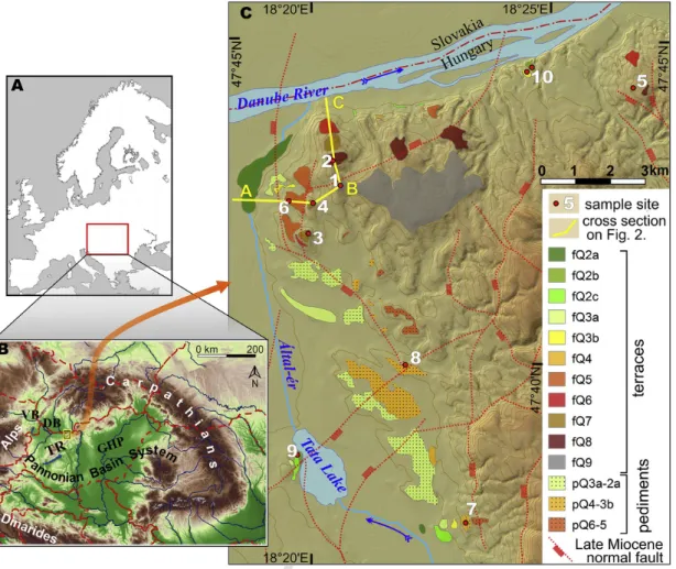
Fig. 1.Location of the study area.A) Position of the Pannonian Basin System in Europe.B) The Pannonian Basin System with the study area (red rectangle) VB: Vienna Basin; DB: Danube Basin; TR: Transdanubian Range; GHP: Great Hungarian Plain; Bp: Budapest, V: Vienna, B: Bratislava. Red dashed lines are state boundaries.C) Digital elevation model of the western Gerecse Hills with the terraces, sample locations and Late Miocene fault pattern with possible post-Miocene reactivation (fault pattern after Fodor et al., 2018). Present floodplains (fQ1) are not mapped. 1: Kőpite Hill, 2: Roman Quarry, 3: Les Hill; 4: Csúcsos Hill, 5: Süttő, 6: Betlehem Quarry, 7: Vértesszőlős, 8: Kender Hill, 9: Tata, 10: Neszmély Upper and Lower. Note that downstream from the Tata Lake the present day Által-ér Creek flows in an artificial channel. Contour line interval is 25m, elevation of the Danube is at 103m asl. (For interpretation of the references to colour in this figure legend, the reader is referred to the Web version of this article.)
al., 1983; Kele, 2009; Kordos, 1994; Kretzoi, 1953; Lantos, 2004;
Osmond, 1990; Ruszkiczay-Rüdiger et al., 2005b, 2016), however, their results are controversial, and invoke the need for novel age determina- tions at several levels of the terrace staircase.
Numerous studies have delivered valuable chronological datasets concerning river terraces and river incision using various dating meth- ods (Rixhon et al., 2017). The advance of the use of in situ-produced cosmogenic radionuclides (CRN) led to the age determination of ter- races either by the cosmic-ray exposure age dating of terraces (Siame et al., 2004; Rixhon et al., 2011; Antón et al., 2012; Stange et al., 2013, 2014; Schaller et al., 2016), or the determination of burial duration of thick terrace sequences (Erlanger et al., 2016; Bender et al., 2016;
Çiner et al., 2015; Zhao et al., 2016) or of sediments trapped in related cave systems (Häuselmann et al., 2007a; Wagner et al., 2010; Rixhon et al., 2014). Several studies have addressed river incision through the joint application of luminescence and cosmogenic nuclides (Anders et al., 2005; DeLong and Arnold, 2007; Guralnik et al., 2011; Viveen et al., 2012; Ruszkiczay-Rüdiger et al., 2016; Braumann et al., 2018).
Different age determination methods (e.g. CRN combined with lumi- nescence, U/Th, paleontology or K Ar and40Ar/39Ar) of terrace- and/
or terrace-covering formations have yielded convergent results (Antoine et al., 2007; Guralnik et al., 2011; Viveen et al., 2012; Thompson et al., 2018; Rixhon et al., 2011; Zhao et al., 2016; Braumann et al., 2018), while on other occasions diverse approaches have led to conflicting terrace ages (Schaller et al., 2016). The problem
of inconsistencies in terrace ages needs to be resolved before evaluating the tectonic and climatic processes involved in valley incision and ter- race formation.
The present study aims to set up a robust terrace chronology in the Danube valley as it crosses the northern-central part of the Pannonian Basin with the use of multiple age determination methods. The study area, the western Gerecse Hills was selected because the terrace stair- case is at its most complete in this area, bounded by the Danube and its tributary the Által-ér creek. The study area may therefore be considered a suitable location for the revision of the terrace system of the Hungar- ian Danube valley.
Due to the presence of sand and gravel-rich terrace sediments and the expected time-span from Late-Pleistocene to Pliocene times, novel terrace ages are obtained using CRN (10Be depth profiles,26Al/10Be bur- ial dating) for the higher and older horizons, and Infrared Stimulated Luminescence (IRSL) for the lower terraces falling within the datable time range of this method. The middle terraces are addressed by both methods for more robust geochronological data.
For a better understanding of the Quaternary landscape evolution, the analysis of the26Al/10Be ratios are used also for the differentiation between primary terrace sediments and re-deposited gravels. Besides, a most probable post-depositional landscape evolution scenario for the highest terrace level is outlined by the modelling of26Al/10Be concen- trations along a burial depth profile.
2
UNCORRECTED
PROOF
In addition to the numerical age determinations, a thorough nomen- clatural and taxonomic revision of the terrace-related faunas was car- ried out, and the revised faunas were set in an up-to date numerical age context.
The new terrace ages are then compared to published magnetostrati- graphic and U/Th data of travertines associated with terraces (Latham and Schwarcz, 1990; Lantos, 2004; Hennig et al., 1983; Schwartz and Latham, 1990; Osmond, 1990; Kele, 2009; Sierrallta et al., 2010). Such comparisons allow the discussion of the suitability and limitations of these methods for the quantification of terrace ages and river incision in an updated geological, geomorphological and geochronological time- frame.
2. Geological and geomorphological setting
The Early- to Middle Miocene extension and the subsequent Late Miocene thermal subsidence of the Pannonian Basin was followed by neotectonic basin inversion. This phase is characterised by ongoing accelerated differential vertical deformation, mainly in the form of large-wavelength folds, blind reverse faults and transpressional struc- tures. Reactivation of normal faults was also possible if they were ori- ented parallel to the main horizontal stress axes at ca. NE-SW in the study area (Horváth and Cloetingh, 1996; Fodor et al., 2005; Dombrádi et al., 2010).
The Transdanubian Range (TR) in the western Pannonian Basin is a topographically elevated NW-SE trending ridge, 300–600m higher than the surrounding lowlands and low hilly areas, with elevations of up to 756m a.s.l. (Fig. 1B).
The Gerecse Hills lie on the northern side of the TR, to the south of the incised Danube River (Fig. 1B and C). Triassic carbonate rocks are exposed in the central part of the Gerecse Hills and are covered by Paleogene to Neogene siliciclastic rocks on the northern and west- ern flanks. The previous deformation phases juxtaposed the Mesozoic and Late Miocene rocks along N-S to NE-SW trending normal or oblique-slip faults (Fodor et al., 2018). Along the main contacts defor- mation of Miocene rocks are clearly exposed, while away from these fault scarps displacements are mostly postulated on the basis of bore- holes. The recognition of neotectonic reactivation of the Late Miocene structures, or alternatively, formation of new, neotectonic elements are hampered by poor outcrop conditions of Plio-Quaternary sediments.
However, there are several geomorphic evidences on the Quaternary deformation of the Pannonian Basin (Pécsi et al., 1984; Fodor et al., 2005. Ruszkiczay-Rüdiger et al., 2009). The uplifting units of the TR separate the subsiding sub-basins of the Danube Basin and the Great Hungarian Plain from each other (Fig. 1B). The Danube is the only river, which cuts through the uplifting pre-Quaternary formations of the TR.
Its terraces at several elevations with concave geometry along the river have been interpreted as indicators of subsequent stages of uplift-dri- ven river incision with different uplift rates along the river (Pécsi, 1959;
Gábris, 1994; Gábris and Nádor, 2007; Ruszkiczay-Rüdiger et al., 2005a, 2016).
In the Gerecse Hills the highest geomorphologic horizons are Ceno- zoic planation surfaces (Kaiser, 1997). The Danube and its tributary, the Által-ér have incised into Upper Miocene siliciclastic rocks and their val- leys are characterised by a coherent system of Late Pliocene–Quater- nary pediment surfaces and Plio-Quaternary river terraces, the main ob- jects of this study (Fig. 1C). The pediments are eroded surfaces of Neo- gene siliciclastic sediments, which may be covered by sheet-wash de- posits in variable thickness and occasionally by alluvial fans of the small tributaries and/or eolian sediments (Csillag et al., 2018).
2.1. Terraces of the Gerecse Hills
Formerly, the terrace chronology of the Danube in Hungary was based mostly on geomorphological, sedimentological and paleontholog- ical data. Terraces were numbered from the lowest to the highest, using increasing Roman numbers as they became older (tI- tVII; Pécsi, 1959;
Gábris, 1994; Ruszkiczay-Rüdiger et al., 2005a, 2016 and references therein). However, our novel age data together with the geomorpholog- ical and geological observations of Csillag et al. (2018) have enabled a challenge to be made to the old system. In this study, terraces are distin- guished from the“traditional”terrace system by the prefix“fQ”(fluvial Quaternary) and the use of Arabic numbers. The level fQ1 is the recent floodplain, and not considered as a terrace. Terraces fQ2 and fQ3 were divided into three and two sub-levels (fQ2c-fQ2b-fQ2a and fQ3b-fQ3a, respectively, Fig. 1).
The base level of the Danube lies at 103±1m a.s.l. and 11 terrace levels form a staircase up to∼180m above the river (fQ2a-fQ9; Fig. 1).
On the western margin of the Gerecse Hills, the terraces have developed in the valley carved by the Által-ér creek, a tributary of the Danube (Fig.
1).The terrace deposits in the study area consist of cross-bedded sandy gravels and gravelly sands of variable thickness, from a few centime- tres up to∼20m. The terraces are frequently covered by travertine de- posited by lukewarm karstwater springs upwelling from the underlying carbonate rocks (Fig. 2; Schréter, 1953; Scheuer and Schweitzer, 1988;
Schweitzer and Scheuer, 1995; Kele, 2009; Török et al., 2017) and by loess (Novothny et al., 2011; Csillag et al., 2018). Fluvial sediments of considerable thickness have been preserved where they were protected by an overlying travertine unit (Figs. 2 and 3).
In the Gerecse Hills, over 50 occurrences of travertine at variable elevations have been identified, mostly located on the northern and western margins of the area. Despite the fact that valley-side and tetarata-type travertines were recognised, travertine formation was gen- erally considered to occur at or close to the base level (Pécsi et al., 1982, 1984; Schweitzer and Scheuer, 1995). Travertines were classified in a way similar to terraces, as a staircase with higher horizons having sub- sequently older ages (T1-T10) (Schweitzer and Scheuer, 1995). The sig- nificance of recent travertine formation is limited, occurring only lo- cally at some lukewarm springs. Currently, travertine thickness ranges from >40m to small, fragmented remnants of a former travertine unit scattered on the surface. The initial total thickness of the travertines is
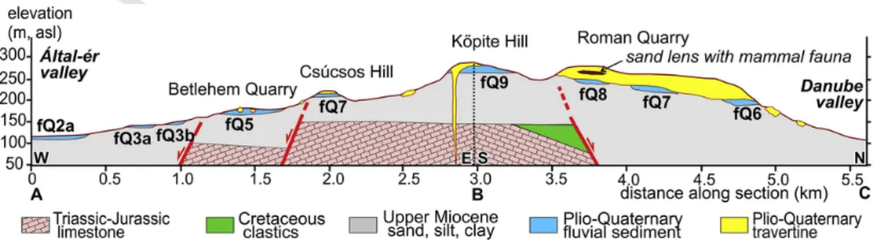
Fig. 2.Simplified cross section of the Gerecse Hills. For location see Fig. 1C.
UNCORRECTED
PROOF
Z. Ruszkiczay-Rüdiger et al. Quaternary Geochronology xxx (2018) xxx-xxx
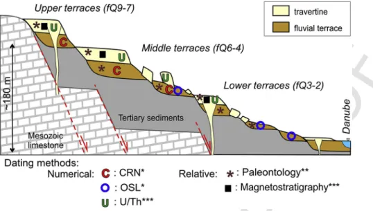
Fig. 3.Schematic cross section of the Western Gerecse Hills, with the geochronological tools applied to the quantification of river incision. * in this study; ** revised by this study; ***
literature data (see details in text). (Note that the cross section is not to scale and the number of terraces is fewer than in the study area).
supposed to have been between 30 and 50m (Scheuer and Schweitzer, 1988; Kele, 2009; Török et al., 2017; Csillag et al., 2018). Travertine units are frequently affected by gravitational sliding, with blocks of 1–10m size displaced downslope from their original position (Schréter, 1953; Csillag et al., 2018).
3. Sampling strategy and methodology
In an earlier study on Danube terraces, Ruszkiczay-Rüdiger et al.
(2016) showed that for river terraces younger than 200–300 ka, IRSL was more suitable as a dating method than CRN due to the likelihood of effective surface denudation. In addition, the number of samples re- quired to perform luminescence dating is smaller than that for a CRN depth profile. Therefore, in this study, lower terraces were only sampled for IRSL dating. With regard to higher surfaces, whose ages may be close to the upper limit of the datable time range of the luminescence method, these were sampled for both IRSL and CRN dating to provide the best possible time constraints on the terrace formation (DeLong and Arnold, 2007; Guralnik et al., 2011; Viveen et al., 2012). The highest horizons were sampled for CRN dating only.
Sample locations were selected on the basis of a detailed geomorpho- logical and geological mapping (for details refer to Csillag et al., 2018).
The mapped terraces are presented in Fig. 1C.
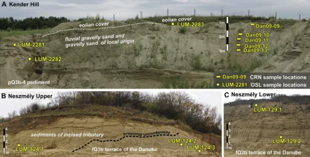
In situ-produced cosmogenic10Be exposure age determination relies on samples collected along depth profiles at two locations (Betlehem Quarry, Kender Hill; n=14). Burial duration determination of the flu- vial sediments relies on the 26Al/10Be nuclide pair ratio measured at three sites (Süttő, Les Hill, Kőpite; n=12). Post-Infrared Infrared Stimu- lated Luminescence (pIRIR290) age determination was performed at four outcrops (Betlehem Quarry, Kender Hill, and the Neszmély Upper and Lower sandpits, n=10).
CRN samples were collected using a shovel from the previously cleaned outcrop in the case of loose material and hammer and chisel when travertine-cemented gravel was sampled. At one location CRN sampling was carried out from a drilling (Kőpite Hill). IRSL samples were taken by pushing metal or light-excluding dark PVC tubes into the previously cleaned wall. The position and elevation of the samples were recorded in the field using a hand-held GPS device (WGS84 reference datum) and cross referenced with 1:10000 topographic maps (Table 1).
To best constrain the terrace ages of the Gerecse Hills, the data ac- quired in this study are compared with published U/Th and magne
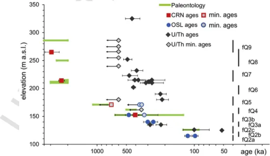
tostratigraphic ages of travertines covering the terraces and therefore providing a minimum age for terrace formation. Paleontological data from the terraces and from the travertine were revised to decide if the numerical and relative age constraints support each other, and if not, to examine any potential reasons for discrepancies. The geochronolog- ical relationship between diverse numerical ages provided by different methods is shown in Fig. 3.
3.1. Cosmogenic nuclides
Several distinct methodologies using CRN are suitable for determin- ing the age of clastic sediments (e.g. Gosse and Phillips, 2001; Dunai, 2010). Both exposure age determination using10Be depth profiles and burial age determination using the26Al and10Be nuclide pair are ap- plied in this study. These approaches depend on the local sedimentolog- ical and geological setting of the outcrop. In the following, the methods of age determination using CRN depth profiles and burial durations are described, while the theory and technical details of age determination and parameters used throughout this study are described in Supplement 1.1.
3.1.1. Exposure age dating along10Be depth profiles
It has been demonstrated that the evolution of the concentration of a single cosmogenic nuclide along a depth profile makes possible to con- strain both the exposure duration and the denudation rate of a relief relying on the well-known relationships dependent on the respective at- tenuation lengths linking spallogenic and muonic production rates to depth (Anderson et al., 1996; Siame et al., 2004; Braucher et al., 2009;
Hidy et al., 2010; Rixhon et al., 2011, 2014; Ruszkiczay-Rüdiger et al., 2011, 2016). If the exposure duration has not been long enough to reach steady state at depth (muonic production), the evolution of the CRN concentration with depth will allow us to arrive at a unique solution of exposure duration and denudation rate and determine the inherited CRN concentration (the concentration accumulated during a previous surface exposure and denudation episode).
If the exposure duration has been long enough to reach a steady state at depth (muonic production), a time averaged denudation rate and a minimum exposure duration corresponding to the minimum time necessary to reach the measured steady-state concentrations (integra- tion time; Lal, 1991) can be calculated (Lal, 1991; Matsushi et al., 2006; Braucher et al., 2009; Hidy et al., 2010; Ruszkiczay-Rüdiger et al., 2016). Exposure duration determination based on depth profiles re
4
UNCORRECTED
PROOF
Table 1
Sample locations. Elevation: Surface elevation (a.s.l.), except for values with*, where CRN sample elevation, due to uncertain thickness of covering travertine; ** Sample sites in the Által-ér valley; pal: revised paleontology.
Location Sample Latitude (DD) Longitude (DD) Elevation. (m) Terrace level Method
Kőpite Dszt-02 to−15 47.7121 18.3358 286 fQ9 CRN burial + pal
Süttő
Gazda Quarry Dan13-01 47.7369 18.4476 218* fQ7? CRN burial + pal
Gazda Quarry Dan13-02 47.7357 18.4469 215* fQ7? CRN burial + pal
Újharaszt Quarry Süttő-19 47.7427 18.4517 255 fQ7? pal
Hegyhát Quarry Süttő-17 47.7391 18.4474 259 fQ7? pal
Cukor Quarry Cukor Quarry 47.7353 18.4514 278 fQ8? pal
Roman Quarry Roman Quarry 47.7185 18.3329 280 fQ8 pal
Les Hill Dan09-05 to−07 47.6998 18.3240 232 fQ7 CRN burial + pal
Csúcsos Hill Csúcsos Hill 47.7076 18.3257 223 fQ7 pal
Betlehem Quarry Dan08-50 to−58; 47.7080 18.3165 178 fQ5 CRN depth profile +
LUM-2284 to−2285 IRSL + pal
Vértesszőlős** Paleolithic site 47.6262 18.3844 182 fQ4 pal
Kender Hill** Dan09-09 to−13 47.6664 18.3610 172 pQ4-3b CRN depth profile +
LUM-2281 to−2283 IRSL + pal
Neszmély Upper LUM-124.1 to−3 47.7417 18.4061 145 fQ3b IRSL
Tata** Porhanyó Quarry 47.6431 18.3205 143 fQ2c pal
Neszmély Lower LUM-129.1 -2 47.7428 18.4081 120 fQ2b IRSL
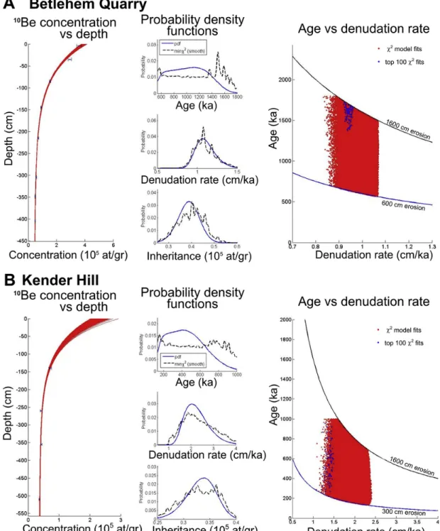
quires that we reach depths at which the muonic production rate is sig- nificant, that is, at least 3–4m. In the study area, this prerequisite re- garding terrace material in its original position was only met at two lo- cations (Betlehem Quarry, Kender Hill; Fig. 1).
First, the integration time was determined at each profile location using the maximum denudation rate relevant for the uppermost sample assuming infinite exposure duration. It was then calculated for the deep- est samples of the profiles where the time necessary to reach the secular equilibrium between CRN production and decay is longer (Braucher et al., 2003). This provides the time range over which the age of the ter- race may be determined using the CRN concentrations measured along a depth profile.
To calculate the most probable exposure age of the sampled ter- races,χ2minimizations were performed using a modified version of the
10Be profile simulator 1.2developed by Hidy et al. (2010), as described by Ruszkiczay-Rüdiger et al. (2016). After preliminary tests, user-de- finedχ2cut-off values were defined for each dataset to provide 100000 model solutions for each simulation, thus fulfilling the requirements of Bayesian statistics. For depth profile modelling, the density of sandy gravel was set at as a free parameter, between 1.8 and 2.2g/cm3, and considered constant along the profiles.
In case the model age tends to be older than the integration time calculated for the lowest sampled level, only the minimum age of the terrace can be determined (Lal, 1991; Ruszkiczay-Rüdiger et al., 2016).
3.1.2. Determination of26Al/10Be burial duration
Cosmogenic26Al and10Be nuclides accumulate in the selected min- eral fraction, in this case quartz, during its surface exposure prior to bur- ial with a well constrained26Al/10Be spallogenic production rate ratio of 6.61±0.52 (updated from Nishiizumi et al. (1989) by Braucher et al.
(2011)). Burial duration determination relies on the differential radioac- tive decay of these cosmogenic nuclides after the quartz minerals have been shielded from further cosmic irradiation due to their burial under a sufficient thickness of matter.
Because the26Al concentrations decrease roughly twice faster than the10Be concentrations, once buried the26Al/10Be ratio decreases expo- nentially, with an apparent half-life of 1.48±0.01 Ma. This allows to estimate burial durations from∼100 ka to∼5 Ma (Granger and Muzikar, 2001; Granger, 2006).
If the thickness of the overlying material is insufficient (<15m) to stop cosmogenic nuclide production, the CRN concentrations measured
in the samples will correspond to the sum of the cosmogenic nuclide concentrations accumulated during the previous exposure episode and of the cosmogenic nuclide concentrations accumulated during the bur- ial duration at the sample depth (accounting for radioactive decay for both). This post-burial production increases the CRN concentrations in the rocks at depth, and may therefore lead to an underestimated burial duration, if not accounted for. Accordingly, a burial duration calculated assuming no post-burial production will therefore represent a minimum burial duration estimate (Lebatard et al., 2014).
As long as environmental conditions can be considered as relatively stable over the burial duration (steady denudation) and post-burial CRN production is taken into account, a maximum burial duration can be es- timated (Lebatard et al., 2014). If no further geological constraints are present, these bracketing durations can therefore be used to assess the duration of the burial (Granger, 2006). If no independent records sug- gest a recent change of sample depth (e.g. rapid stripping of a consider- able thickness of the overlying material), the latter model accounting for steady denudation and post-burial CRN accumulation usually provides more realistic burial duration estimates.
3.2. Luminescence dating
As was the case with cosmogenic nuclides, the applied methods of lu- minescence age determination will be described here, while the method- ological bases and parameters used throughout this study can be found in Supplement 1.2.
3.2.1. Age determination using the pIRIR290technique
In this study, pIRIR290 dating was applied to K-feldspar in cases in which the expected age of the sediments of interest was estimated to be potentially out of the range of the quartz blue light stimulated luminescence dating method. The pIRIR290measurements were made using Risø TL/OSL automatic readers with a calibrated90Sr/90Y beta source at the Institute of Geography and Geology of Eötvös Univer- sity, Budapest (ELTE) and at the Mining and Geological Survey of Hungary (MBFSZ, formerly the Geological and Geophysical Institute of Hungary). According to the grain size of the sediments, coarse-grain K-feldspar fractions either between 100 and 150, 150 and 200, or be- tween 250 and 300μm were measured on small and medium aliquots using post-IR elevated temperature IRSL (Buylaert et al., 2009; Thiel et al., 2011, 2012). This Single-Aliquot Regenerative-dose (SAR) protocol
UNCORRECTED
PROOF
Z. Ruszkiczay-Rüdiger et al. Quaternary Geochronology xxx (2018) xxx-xxx
contains 320°C preheat for 60s, IR stimulation and measurement first for 200sat 50°C, then for 200sat 290°C (pIRIRSL290signal), illumina- tion for 100sat 325°C in the last step of each cycle beside the test dose and different regeneration doses.
Dose-response curves were fitted using a single saturation exponen- tial function. If the pIRIR290signal of a sample was saturated, only the minimum age was calculated, based on the 2*D0(dose level character- istic of the dose-response curve) value from a single exponential growth curve corresponding to about 86% of saturation (Wintle and Murray, 2006; Murray et al., 2014). In the case of the unsaturated samples, the measured aliquots were accepted if their test dose error was <10%, re- cuperation <5%, recycling ratio in the range of 1.0±0.1, and equiva- lent dose (De) < 2*D0
The age calculation of the unsaturated samples was based on nat- ural equivalent dose measurements performed on 6 to 11 aliquots per sample, while fewer aliquots per sample were measured in the case of saturated samples. In case of samples from Kender-Hill and Betle- hem Quarry (Lum 2281–2285) small aliquots (d=2mm), in case of the samples from Neszmély medium aliquots (d=5mm) were used for the measurements. Low overdispersion (<20%) of the Devalues with a more or less symmetric distribution is indicative of well bleached sed- iments at the time of deposition, and according to Olley et al. (2004) the central age model should be used to calculate their burial doses.
Dose rate calculation based on high-resolution gamma spectrometry (CANBERRA-PACKARD) measurements using the conversion factors of Adamiec and Aitken (1998). Cosmic dose rates were calculated accord- ing to Prescott and Stephan (1982) and Prescott and Hutton (1994).
12.5±0.5% internal K content was considered for feldspar (Huntley and Baril, 1997). Based on the measurements of in-situ and saturated water content of the dated sediments, the ages were calculated using 10–12.5±2% dry-weight moisture content for the Neszmély samples and 10±5% for the Betlehem Quarry and Kender Hill samples.
3.3. Paleontology
Among the numerous fossil-bearing locations of the Gerecse Hills (Jánossy, 1986; Krolopp, 1990, 1995; 2014; Pazonyi, 2006; Gasparik and Kele, 2010; Pazonyi et al., 2014), the present study focuses only on remains directly unearthed from terrace material (Betlehem Quarry, Csúcsos Hill, Kender Hill) or from travertine (Kőpite Hill, Les Hill, Süttő, Vértesszőlős), or from interbedded sediments and fissure infillings in freshwater limestone (Roman Quarry, Süttő, Tata). Fossil sites and fau- nas not connected to geomorphic levels (caves, paleosols and loess se- quences), lie beyond the scope of this study.
Previously published faunal lists of the sites were nomenclaturally and taxonomically revised based on material stored in the Vertebrate Paleontological Collections of the Hungarian Natural History Museum (HNHM) and the MBFSZ. In addition, thin sections were made from the enamel of mammoth molars from Csúcsos Hill and Les Hill, following the method developed by Ferretti (2003, 2008), Vasile et al. (2012), and Virág (2013). The malacological record was also revised on the ba- sis of stratigraphic correlations provided by Krolopp (1995, 2014), and finally, numerical age boundaries were revised based on Lisiecki and Raymo (2005); Gibbard and Van Kolfschoten (2005), Maul and Markova (2007) and Cohen and Gibbard (2016).
4. Sample sites and dating results
Several dating approaches were applied for the age determination at each sample location. In order to avoid abundant repetitions, in the fol- lowing sections site descriptions appear together with dating results.
4.1. Terrace fQ9, Kőpite Hill
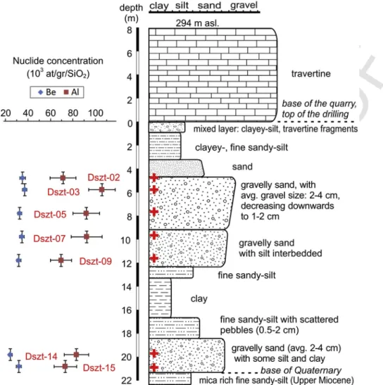
A Pliocene to Early Pleistocene age had previously been assigned to the Kőpite Hill (fQ9, 286m a.s.l. Figs. 1 and 2), one of the highest terraces of the Danube valley in the study area (Pécsi, 1959; Scheuer and Schweitzer, 1988). Gravelly and sandy sediments of∼21m thick- ness overlie Upper Miocene deltaic-littoral sediments at∼265m a.s.l.
and were subsequently covered by travertine (Csillag et al., 2018) (Fig.
4). Sediments above and below 12m depth might belong to two sub- sequent sedimentation phases (Fig. 4). The U/Th age of the travertine lies beyond the 600 ka limit of the method (Kele, 2009), and an imprint of anAnancus arvernensis lower third molar (inventory code: HNHM V.72.4) in the travertine suggests an age of at least 2 Ma (Jánossy, 1986;
Gasparik, 2001).
The sampling at the Kőpite Hill was performed along a drilling car- ried out at the base of an abandoned travertine quarry located at the top of the hill (286 a.s.l.). Currently the elevation of the hilltop (top of the travertine at the rim of the quarry) is 292m a.s.l. According to the Third Military Survey of Hungary (1869–1887), this altitude was 294m be- fore quarrying. Therefore, at least 8m of travertine has been recently re- moved from the terrace surface. This missing cover thickness was taken into account when performing CRN burial duration modelling.
One sample was taken every 1m along the depth interval of 5–21m.
Of these, seven samples were selected for26Al/10Be burial duration de- termination (Dszt-02 to−15; Fig. 4). However, as it was performed us- ing a spiral head, the drilling did not allow recovery of undisturbed sediment samples, which generates an uncertainty of∼50cm in sample depths (Tables 1 and 2).
The 0.25–1mm fraction of the selected samples was used for CRN analysis. The evolution of both the10Be and26Al concentrations as a function of depth modelled using the reducedχ2test (Ward and Wilson, 1978) indicated the presence of 2 outlier samples (Dszt-02, -14), which were accordingly omitted from the burial duration modelling and from the discussion (Figs. 4 and 5).
The dataset under consideration enabled the modelling of the terrace age in several different ways. These are presented here from the simplest (1) to the more complex (4). For each model, pre-burial CRN production rates were assessed using an estimate of the average elevation (600m) and latitude (N48°) of the upstream Danube catchment and a density of 2.6g/cm3, as these were more relevant than the elevation, latitude and density at the sample site. The four models were the following:
(1) The “simple bracketing model”: minimum-maximum burial durations (Suppl. Fig. 1A);
(2) The“burial depth profile (BDP) model”: assuming similar pre- and post-depositional histories of the samples using linearized data (Suppl. Fig. 1B);
(3) The “BDP model with hiatus”: as in (2), but accounting for a hiatus between the terrace abandonment and the travertine precipitation (Suppl. Fig. 1C);
(4) The“BDP model with travertine aggradation”: as in (2), but including a period of travertine aggradation after the terrace abandonment (Suppl. Fig. 1D).
4.1.1
(1) The“simple bracketing model”
(1a) The use of the model without post-burial production and assuming infinite burial depth yields minimum bur- ial duration estimates between 1.87±0.23 Ma and 2.42±0.36 Ma. This corresponds to the minimum du- ration necessary to reach the measured26Al/10Be ratios from the lower curve (steady denudation) in the expo- sure-burial diagram, plotting the 26Al/10Be ratios as a
6
UNCORRECTED
PROOF
Fig. 4.Lithology and sampled depths for burial depth profile modelling with measured CRN concentrations at the fQ9 terrace at Kőpite Hill (CRN sample positions are marked by red crosses and red numbers are the CRN sample codes). Note that the travertine thickness is estimated, and the drilling started from the bottom of the quarry. (For interpretation of the references to colour in this figure legend, the reader is referred to the Web version of this article.)
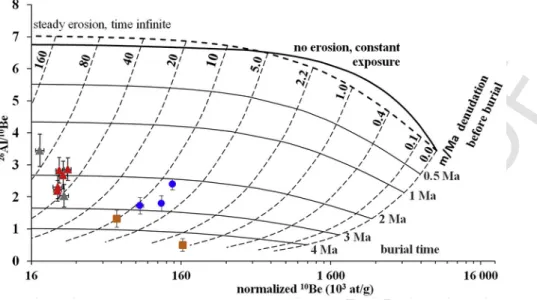
function of their associated 10Be concentrations (Granger, 2006, Fig. 5). The Kernel Density Estimate (KDE; Vermeesch, 2012) of the minimum burial ages and maximum denudation rates of the samples yields to the KDE minimum burial duration of 2.03±0.13 Ma and KDE pre-burial denudation rate of 52±3m/Ma, respec- tively (Suppl. Fig. 2A and B; Table 1, Suppl. Table 1).
(1b) Assuming steady denudation and post-burial CRN pro- duction, the maximum figure for the burial duration of the samples ranges from 2.35±0.37 Ma to 3.85±0.63 Ma, with the KDE burial duration of 2.91±0.19 Ma. The KDE pre- and post-burial denudation rates are 66±4m/
Ma and 9±1m/Ma, respectively (Suppl. Fig. 2C–E;
Table 1, Suppl. Table 1). An initial travertine thickness of 33±2m was calculated for this scenario (the sum of the travertine thickness removed recently by quarry- ing (8m) and the thickness eroded since terrace aban- donment (burial duration×post-burial denudation rate, 25±2m)).
4.1.2
(2) The“burial depth profile (BDP) model”
(2a) The samples are treated as a buried depth profile con- sisting of samples that share the same pre- and post-bur- ial histories (see details in Supplement 2.1). This model yielded a burial duration of 2.61±0.39 Ma and a post-
burial denudation rate of 16.4±2.4m/Ma (Table 3). In this scenario, the total thickness of travertine eroded/
dissolved from above the terrace is 43±6m, suggesting an initial travertine thickness of 51±6m, which is sim- ilar to the maximum travertine thickness values previ- ously proposed for the area (Török et al., 2017; Csillag et al., 2018). The deduced pre-burial denudation rates are 72±11m/Ma and 57±9m/Ma for the upper and lower sequence, respectively.
(2b) As a subsequent step, the post-burial denudation rate was limited to 10m/Ma, the highest denudation rate es- timate from horizontal terrace surfaces in the area (10Be depth profile data; Ruszkiczay-Rüdiger et al. (2016) and this study), and a value similar to the denudation rate yielded by the KDE model taking into account post-bur- ial CRN production. Applying this limit, the calculated burial duration is 2.93±0.43 Ma, in agreement with the KDE maximum age of the terrace. The thickness of eroded travertine is 29±4m, giving an initial traver- tine thickness of 37±4m, in agreement with the aver- age travertine thickness over the area. Considering the associated uncertainties, the pre-burial denudation rates are similar to those previously deduced from the model (2a), of unconstrained post-burial denudation rate (Table 3).
UNCORRECTED
PROOF
Table 2
Burial dating sample data.10Be/9Be ratios of process blank were (1.23±0.43)×10−15(samples Dan09-05 to-07), (2.37±0.71)×10−15(samples Dan13-01,-02) and (6.34±1.58)×10−15 (all Dszt samples).26Al/27Al ratios of machine blank were (2.20±2.00)×10−15(samples Dan09-05 to-07), (4.80±1.96)×10−15(samples Dan13-01,-02) and (2.97±1.21)×10−15(all Dszt samples). CRN concentrations were corrected for self-shielding and were not corrected for geomagnetic variations. Topo- graphic shielding factor is 1 for all sites.
Depth (cm) Thickness (cm)
Mass of quartz
dissolved (g) [10Be] concentration
(atoms/g) [26Al] concentration (atoms/g)
26Al/10Be
Ratio Model (1a) with no post-burial
production Model (1b) with post-burial production
Sample Min. burial age
(ka)
Pre-burial denudation rate (m/
Ma) Max burial age
(ka)
Pre-burial denudation rate (m/
Ma)
Post-burial denudation rate (m/Ma)
Dszt-02 475 ±25 10 40.8096 34928 ±2389 71079 ±11413 2.04 2575 ±454a 39.2 ±6.9a 4819 ±850a 20.7 ±3.6a 24.0 ±4.2a
Dszt-03 575 ±25 10 39.0662 36946 ±1942 105771 ±11748 2.86 1870 ±235 53.1 ±6.7 2823 ±354 63.8 ±8.0 14.6 ±1.8
Dszt-05 775 ±25 10 40.0289 32384 ±1700 91797 ±11902 2.83 1893 ±269 60.1 ±8.5 3362 ±478 78.7 ±11.2 9.5 ±1.3
Dszt-07 975 ±25 10 38.5092 34428 ±2161 92228 ±13763 2.68 2008 ±329 53.2 ±8.7 3851 ±631 67.7 ±11.1 5.3 ±0.9
Dszt-09 1175 ±25 10 39.8691 31591 ±1828 69310 ±9468 2.19 2422 ±365 47.0 ±7.1 2999 ±451 55.6 ±8.4 20.3 ±3.0
Dszt-14 1975 ±25 10 38.7988 24039 ±1613 83003 ±10724 3.45 1488 ±220a 99.9 ±14.8a 1344 ±199a 138.4 ±20.5a 33.6 ±5.0a
Dszt-15 2075 ±25 10 39.3390 31635 ±2330 73014 ±10067 2.31 2318 ±367 49.5 ±7.8 2351 ±372 73.2 ±11.6 10.3 ±1.6
KDE 2031 ±133 52.1 ±3.4 2912 ±193 65.7 ±4.3 8.5 ±0.6
Dan09-05 465 ±10 10 39.4137 147508 ±5677 264355 ±33455 1.79 2754 ±371 7.8 ±1.1 4063 ±547 4.6 ±0.6 15.1 ±2.0
Dan09-06 503 ±10 10 44.7793 174938 ±5770 418103 ±25923 2.39 2165 ±161 8.9 ±0.7 2757 ±206 7.6 ±0.6 14.3 ±1.1
Dan09-07 603 ±10 10 44.8995 106368 ±6302 183024 ±24977 1.72 2864 ±432 10.5 ±1.5 4558 ±688 5.3 ±0.8 15.7 ±2.4
KDE 2323 ±140 8.8 ±0.5 3.038 ±186 6.0 ±0.4 14.7 ±0.9
Dan13-01 3000 ±500b 10 15.6852 204313 ±7488 101034 ±40008 0.49 5158 ±2055 1.3 ±0.5
Dan13-02 2500 ±500b 10 16.3245 74307 ±3720 98256 ±19180 1.31 3436 ±747 11.3 ±2.3
KDE: Kernel density estimate ages and denudation rates. (See details in text and on Suppl. Figs. 2, 3).
a Values excluded from modelling as outliers.
b Sample depth was estimated.
UNCORRECTED
PROOF
Fig. 5.Exposure-burial diagram of the samples showing minimum burial durations and associated pre-burial denudation rates, assuming complete shielding (Model (1a)). Triangles:
Kőpite Hill, dots: Les Hill, rectangles: Süttő. Grey triangles were omitted from modelling as outliers.
Table 3
Burial duration modelling results of the Kőpite Hill. For more details, refer to the text and to the Suppl. Table 1.”Pre-burial denudation rate (upper)”refers to values modelled for the samples from the upper sedimentary unit, and“(lower)”refers to the lowermost sample (Dszt-15; Fig. 4).
Kőpite Hill, fQ9 terrace Model (2a) Model (2b) Model (4a) Model (4b)
burial duration (ka) 2614 ± 387 2929 ± 434 2588 ± 431 2942 ± 489
pre-burial denudation rate (upper, m/Ma) 72.2 ± 10.7 80.2 ± 11.9 74.0 ± 12.3 82.9 ± 13.8
pre-burial denudation rate (lower, m/Ma) 57.4 ± 8.5 53.6 ± 7.9 58.5 ± 9.7 54.0 ± 9.0
post-burial denudtion rate (m/Ma) 16.4 ± 2.4 10 ± 0 17.2 ± 2.9 10.0 ± 0
initial travertine thickness (m) 50.9 ± 7.5 37.3 ± 5.5 48.8 ± 6.7 35.0 ± 4.5
travertine eroded (m) 42.9 ± 6.3 29.3 ± 4.3 40.1 ± 6.7 26.9 ± 4.5
duration of travertine aggradation (ka) 250.0 250.0
travertine aggradation rate (m/Ma) 195.0 140.0
4.1.3
(3) The“BDP model with hiatus”
As a next step, a period of surface exposure of the terrace before its burial by the travertine was introduced in the model. Interestingly, this results in zero surface exposure duration for the terrace prior to the de- position of the travertine, indicating that there was no hiatus between terrace abandonment and travertine deposition. Consequently, the bur- ial duration and the denudation rate estimated by this model were simi- lar to those estimated using model (2) (Suppl. Table 1). The assumption of a scenario in which there is negligible surface exposure and denuda- tion of the terrace before travertine precipitation is supported by the thickness of the alluvial sediments beneath the travertine unit.
4.1.4
(4) The“BDP model with travertine aggradation”
(4a) The CRN burial duration of the terrace was modelled accord- ing to two scenarios: the duration of travertine precipitation
(taggr) fixed at either 250 ka or 300 ka (for details refer to
Supplement 2.1)
In the first scenario (taggr=250 ka), the required conditions are ful- filled with a travertine aggradation rate of 195m/Ma. The resulting bur- ial duration of the terrace is 2.59±0.43 Ma with a post-travertine de- nudation rate of 17.2±2.9m/Ma (Table 3; Suppl. Table 1). Assuming that thetaggrlasted 300 ka, the best fit travertine aggradation rate is 160m/Ma, the burial duration and the post-travertine denudation rate being similar to those resulting from the first scenario.
(4b) Maximizing the post-travertine denudation rate at 10m/Ma (like in model (2b)) leads to a burial duration of 2.94±0.49 Ma for both scenarios, with travertine aggradation rates of 140m/Ma and 115m/Ma in the first and second scenarios, respectively. The re- sulting terrace burial ages are indistinguishable from the results of model (2) (Table 3; Suppl. Table 1).
4.2. Terrace fQ8, Roman Quarry
To the north of the Kőpite Hill a large travertine complex is exposed by the Roman Quarry on a ridge at an elevation of 280–260m a.s.l.
(Figs. 1 and 2; Table 1). The gravelly sediments underlying the traver- tine were described only at the borders of the travertine unit. Geophys- ical measurements indicated that the base of the gravelly sediments lies at∼245m a.s.l. (Kiss et al., 2015), suggesting that the upper part of the travertine complex, where a fauna-bearing loess layer is intercalated within the travertine, covers the fQ8 horizon. To the north, another gravel horizon is exposed below the travertine at∼190m a.s.l. On the basis of its elevation, this sediment should belong to the fQ6 level, sug- gesting that the travertine has covered several terrace horizons (Figs. 1 and 2).
Based mainly on the presence of thePitymimomys pitymyoidesvole, the small mammal fauna described from the loess layer within the travertine belongs to the Late Villanyian (Jánossy, 1986). This is equiv- alent to the MN17 or 2.6–1.95 Ma (Fejfar et al., 1997), and provides a minimum age for the underlying fQ8 terrace.
UNCORRECTED
PROOF
Z. Ruszkiczay-Rüdiger et al. Quaternary Geochronology xxx (2018) xxx-xxx
The reversed polarity of the Roman Quarry travertine brackets its de- position during the Matuyama chron (2.6–0.8 Ma; Lantos, 2004), which is in line with the paleontological age. The U/Th age of >600 ka (Kele, 2009) for the upper part of the travertine (at 264m a.s.l.) does not con- tradict these data.
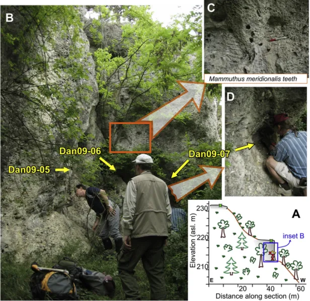
4.3. Terrace fQ7, Les Hill
The top of the Les Hill (232m a.s.l.) is composed of travertine-ce- mented sandstone, the overbank fines of the Danube terrace (fQ7) (Fig.
1, Table 1). In a somewhat lower position, in the wall of an abandoned quarry (214–220m a.s.l.), travertine-cemented fluvial sandy-gravel is exposed, and is interpreted as the lower part of the same normal graded terrace sequence with an overall thickness of∼18m (Fig. 6). Small peb- bles appear at a depth of∼12m, at the top of the abandoned quarry wall. Conglomerate, with an average pebble size of 2–3cm (up to 5cm), appears in the middle and lower sections of the outcrop (beneath a depth of∼14m). The surface of the abandoned quarry presents a some- what uncertain picture, as the recent removal of a considerable thick- ness of sediments from above the sampled quarry wall is possible,
given that limestone quarrying in the area started as early as of the times of the Roman Empire.
Three in situMammuthus meridionalis teeth were described within the sandy gravel body (Halaváts, 1898; Schréter, 1953; Scheuer and Schweitzer, 1988, Fig. 6). The overall morphology of the teeth and the microstructure of their enamel place them as transitional betweenM. ru- manus(latest Pliocene to earliest Pleistocene) andM. meridionalis(Early Pleistocene). Based on their ancient morphology, the studied molars can be identified as early representatives of the latter taxon (Virág and Gasparik, 2012; Virág, 2013), suggesting an age of 2.4–2.0 Ma for this terrace.
The prevailing reversed magnetic polarity, with a short period of normal polarity in the upper part of the sequence places the travertine of the Les Hill in the older part of the Matuyama chron, around the Olduvai event (2.6–1.6 Ma; Lantos, 2004).
By way of contrast, freshwater limestone from a neighbouring travertine quarry on the Les Hill yields U/Th ages ranging from 408±73 ka to 273±73 ka (n=3; Kele, 2009), that is, considerably younger than the paleontological and magnetostratigraphic ages.
The sandstone at the hilltop and on the top of the outcrop and peb- bles of cm size at 4–6m depth in the conglomerate were sampled to es
Fig. 6.The sample site exposing the travertine-cemented gravel of the fQ7 terrace at Les Hill.A: Field sketch on the position of the sampled outcrop. Note that green crosses show the position of CRN samples that could not be processed due to the small amount of quartz remaining after purification.B: The sampled outcrop with the sample positions.C: TwoMammuthus meridionalisteeth embedded in the terrace material. D: a closer view of the location of sample Dan09-07. (For interpretation of the references to colour in this figure legend, the reader is referred to the Web version of this article.)
10
UNCORRECTED
PROOF
timate exposure and burial duration from the resulting26Al/10Be depth profile (n=5; Fig. 6). Unfortunately, the sand contained in the two sur- face samples was totally dissolved in the course of quartz separation and leaching (Dan09-03,−04; do not appear in Table 2), and only the re- maining 3 deep samples from the 4.7–6.0m depth range could be used for the measurement of their26Al and10Be concentrations (Dan09-05 to
−07; Table 2; Fig. 6).
The burial duration of the fQ7 terrace at the Les Hill was estimated using the“simple bracketing model”(Model (1)).
(1a) Assuming complete burial and no post-burial production (i.e. the recent truncation of >10m material), a minimum burial dura- tion of 2.17±0.16 Ma for the youngest sample, together with an 8.9±0.7m/Ma pre-burial denudation rate were obtained (Fig. 5).
The KDE of the calculated minimum burial durations leads to a minimum KDE burial duration of 2.32±0.14 Ma with a pre-burial denudation rate of 8.8±0.5m/Ma (Table 2, Suppl. Fig. 3A and B).
(1b) Assuming stable conditions after burial and taking post-burial pro- duction into account, a maximum KDE burial duration of 3.04±0.19 Ma is estimated with a pre-burial denudation rate of 6.0±0.4m/Ma and a post-burial surface denudation rate of 14.7±0.9m/Ma (Table 2, Suppl. Fig. 3C–E).
4.4. Terrace fQ7, Csúcsos Hill
A travertine-cemented conglomerate unit was described on the Csúcsos Hill (223m a.s.l. Figs. 1 and 2, Table 1) with an estimated thick- ness of∼8m above Upper Miocene sandy sediments (Schréter, 1953).
The oncoidic structure of the travertine around the pebbles suggests that the fluvial material was deposited close to the karstwater spring. To the north, northwest from the peak, at∼215m a.s.l. several travertine units without siliciclastic sediments have also been described (Scheuer and Schweitzer, 1988); these most probably cover the same terrace horizon.
Four Mammuthus meridionalis teeth were mentioned from the Csúcsos Hill conglomerate by Scheuer and Schweitzer (1988). Their morphological and microstructurural study (Virág and Gasparik, 2012;
Virág, 2013; HNHM V.82.49, HNHM V.82.50, HNHM V.88.11, and a lower left m3 without an inventory number) suggests their similarity to the teeth from the Les Hill. These are therefore also considered to be early representatives ofM. meridionaliswith a most probable age range of 2.4–2.0 Ma.
4.5. Terrace fQ8-7 (?), Süttő
To the south of Süttő village, one of the largest travertine deposits in Hungary is exposed in several active quarries at elevations, ranging from 278 to 215m a.s.l. (Fig. 1, Table 1). The underlying gravelly sed- iments (gravelly-sandy clay and travertine-cemented gravel) have been described as a Danube terrace (tV, Pécsi et al., 1984). Given the signifi- cant elevation range, several terrace horizons (fQ6-7-8) may have been covered by the travertine (similarly to the Roman Quarry travertine on Fig. 2). The gravel-bearing sediments (1–10m thick) cover the eroded surface of Upper Miocene sand.
The travertine beds follow pre-existing valleys, and travertine pre- cipitation took place on gently sloping terrain (Török et al., 2017). The recent re-evaluation of the drill hole data in and around the travertine complex suggests that the gravel at the base of the travertine is not in its original position, but has been re-deposited from an older terrace, or from Eocene siliciclastic lithologies (Csillag et al., 2018). The traver- tine is fractured by several fissures filled with sediments post-dating the formation of the travertine (Pazonyi et al., 2014). Most of the fractures
are the result of the gravitational sliding of the travertine above the sandy-clayey basal sediments (Török et al., 2017).
Among the numerous fossil remains (Pazonyi et al., 2014), only the occurrences providing information on the time of travertine precipita- tion are mentioned (Table 1).
At the highest position (Cukor Quarry; 270-260m a.s.l.), the co-oc- currence ofMimomys pusillusandMimomys pliocaenicusin cemented red clay filling a cave within the travertine suggests an age of 2.0–1.8 Ma age (second half of the MN17) (Pazonyi et al., 2014). This provides a minimum age for the travertine. A sandy gravel unit with no fauna out- cropping next to the Cukor Quarry at (∼265–275m a.s.l) was tentatively correlated with the fQ8 terrace (Fig. 1).
An age range of 2.0–0.8 Ma is suggested by the presence ofMimomys pusilluswithin the red clay layer at the somewhat lower-lying Újharaszt Quarry (250-240m a.s.l.; Süttő 19).
At a similar elevationAnancus arvernensis,Dicerorhinuscf.jeanvireti, Cervus cf.philisihave been found in the travertine (Hegyhát Quarry, 255-240m a.s.l.) in addition toArvernoceroscf.ardeifound in the top layer of the neighbouring Gazda Quarry (240-215m a.s.l.) (Jánossy and Krolopp, 1981). Considering the bio-stratigraphic ranges of these verte- brates, a minimum age of∼2.0 Ma can be assigned to this site.
The 1.0–0.9 Ma minimum age of the fauna (co-occurrence ofMi- momys savini, Pliomys episcopalis, P. lenki, Microtus(Allophaiomys)plio- caenicus, Microtus(Terricola)hintonivoles) from a fissure infilling (red clay covered by sandy loess) within the upper travertine unit (Süttő 17, Hegyhát Quarry) is in agreement with an age of >2 Ma for the host rock.
The magnetic polarity of the travertine at Süttő is variable. Both re- versed and normal polarity sections have been described in two quar- ries, and travertine formation around the Matuyama-Gauss boundary has been suggested (3–2.1 Ma; Lantos, 2004).
In contrast, U/Th ages ranging between 422 and 210 ka (Kele, 2009;
Sierrallta et al., 2010) suggest a Middle Pleistocene age for travertine precipitation. In addition, the U/Th ages do not exhibit a consistent trend with the stratigraphic order within the travertine unit. On the top of the eroded surface of the Süttő Travertine Complex an Upper Pleis- tocene loess layer, dated by OSL, was deposited (Novothny et al., 2011).
For26Al/10Be burial duration determination two samples were col- lected from the gravelly sediment underlying the 20–50m thick traver- tine complex in the Gazda Quarry, at an elevation corresponding to the fQ7 terrace (Fig. 7). Dan13-01 was collected from the gravelly clay be- low the travertine, and Dan13-02 originated from a travertine-cemented conglomerate block at the base of the quarry. Sample depths had to be estimated, since all or part of the travertine covering the gravel has been removed by quarrying (Table 2). Low 26Al/10Be isotopic ratios yield to 5.16±2.06 Ma and 3.44±0.70 Ma minimum burial duration esti- mates for the gravelly clay and conglomerate, respectively, assuming no post-burial CRN production. The associated pre-burial denudation rates are 1.3±0.5m/Ma and 11.3±2.3m/Ma, respectively (Fig. 5, Table 2).
Due to the low CRN concentrations and great thickness of the cover, the model including post-burial CRN production was not performed on these samples.
4.6. Terrace fQ5, Betlehem Quarry
In the abandoned gravel pit of the Betlehem Quarry, a Middle Pleistocene (?) Danube terrace (178m a.s.l. fQ5) is exposed on the north-western slope of the Csúcsos Hill (Figs. 1 and 2, Table 1). The sandy gravel of the terrace is poorly sorted. The thickness of the Qua- ternary fluvial sediments is estimated to be∼7m, because the contact could not be properly studied due to its coverage by debris (Fig. 8). Sev- eral large travertine blocks (up to∼5–6m size) are present within the terrace gravel. Whether they represent remnants of a former freshwater
UNCORRECTED
PROOF
Z. Ruszkiczay-Rüdiger et al. Quaternary Geochronology xxx (2018) xxx-xxx
Fig. 7. A: The travertine quarry (Gazda Quarry) of Süttő with the gravelly clay layer, the CRN sample location Dan13-01.The circled excavator gives a sense of scale.B: A closer view of the gravelly clay at the base of the travertine.C: The travertine-cemented conglomerate of Dan13-02 sample coming from the opposite wall of the same quarry.
Fig. 8.The abandoned gravel pit exposing the fQ5 terrace at Betlehem Quarry sample location.A: The10Be depth profile;B: The profile with OSL samples;C: An overview of the outcrop with the sampled profiles. 1:10Be sample; 2: OSL sample; 3: Fluvial gravel and sand; 4: Travertine; 5: Upper Miocene cross laminated sand; 6: debris with cobbles; 7. position of the profiles shown by the A and B insets. sg: sandy gravel (with main pebble size); cs: coarse sand.
limestone spring cone (Scheuer and Schweitzer, 1988; Viczián, 2013), or had slumped gravitationally in the terrace material from a higher travertine body (Scheuer, 1997) is open to debate. Recent geophysi- cal measurements (Kiss et al., 2014) do not provide evidences for the presence of deeper travertine deposits, but do support the likelihood of travertine blocks“floating”in the sandy-gravelly material (Fig. 2).
The gastropod assemblage described from the fluvial sediment of the Betlehem Quarry suggests a late Early Pleistocene age for the ter- race:∼1.1–0.78 Ma (Gastrocopta sacraecoronaeSubzone; youngest part ofViviparus boeckhi Zone (Krolopp, 1995, 2014). In addition, Viczián (2013) described a fragmentedMammuthus meridionalismolar from the upper part of the fluvial material. The biostratigraphical range of this taxon is regionally 2.4–0.8 Ma. As the specimen was lost, it was not
12