DOI: 10.1515/jengeo-2017-0005
ISSN: 2060-467X
CENTURIAL CHANGES IN THE DEPTH CONDITIONS OF A REGULATED RIVER:
CASE STUDY OF THE LOWER TISZA RIVER, HUNGARY
Gabriel Jonathan Amissah
1*, Timea Kiss
1, Károly Fiala
21Department of Physical Geography and Geoinformatics, University of Szeged, Egyetem u. 2-6, H-6722 Szeged, Hungary
2Lower Tisza District Water Directorate, Stefánia 4, H-6720 Szeged, Hungary
*Corresponding author, e-mail: gabbyjonad@yahoo.com
Research article, received 1 March 2017, accepted 26 May 2017
Abstract
The Tisza River is the largest tributary of the Danube in Central Europe, and has been subjected to various human interventions in- cluding cutoffs to increase the slope, construction of levees to restrict the floodplain, and construction of groynes and revetments to stabilize the channel. These interventions have altered the natural morphological evolution of the river. The aim of the study is to assess the impacts of these engineering works, employing hydrological surveys of 36 cross sections (VO) of the Lower Tisza River for the years of 1891, 1931, 1961, 1976 and 1999. The changes in mean depth and thalweg depth were studied in detail comparing three reaches of the studied section.
In general, the thalweg incised during the studied period (1891-1931: 3 cm/y; 1931-1961: 1.3 cm/y and 1976-1999: 2.3 cm/y), except from 1961-1976 which was characterized by aggradation (2 cm/y). The mean depth increased, referring to an overall deepening of the river during the whole period (1891-1931: 1.4 cm/y; 1931-1961: 1.2 cm/y; 1961-1976: 0.6 cm/y and 1976-1999: 1.6 cm/y). The thalweg shifted more in the upper reach showing less stabile channel, while the middle and lower reaches had more stable thalweg. Although the cross-sections subjected to various human interventions experienced considerable incision in the short-term, the cross-sections free from direct human impact experienced the largest incision from 1891-1999, especially along the meandering sections.
Keywords: thalweg, channel depth, Lower Tisza River, river regulation, morphological changes
INTRODUCTION
Rivers have been altered by human impacts for centuries for economic benefits (flood protection, improvement of shipping routes, energy production, water withdrawal etc.). It is important to understand the consequences of these interventions, since such hydro-morphological and ecological information are crucial to any sustainable fu- ture river engineering (Hooke, 1995). The sediment load and its characteristics reflect the overlapped effects of all environmental subsystems of the river’s catchment (Fryirs and Brierly, 2001; Fryirs et al., 2007, 2008). If, any of these subsystems change, it should be reflected in the se- diment transport, thus in the channel forms of a river (Chruch, 2006; Anderson and Anderson, 2010; Has- sanzadeh, 2012). Therefore, alluvial channel morphology is the result of the interactions between channel-bed to- pography, flow field and sediment movement (van der Berg, 1995; Ferguson, 2010; Latapie et al., 2014; Leigle- iter, 2014; Powell, 2014).
Although rivers are natural transporters and ex- porters of sediments, usually direct human activities on the channel adversely affect this capacity (Yang et al.
2014). The different human impacts have increasingly re- duced the amount of transported sediments, as usually
they trap or dredge the sediments i.e. by channel straighte- ning, embanking, widening, removal of riparian vegeta- tion and urbanization (Osei et al. 2015). When these ar- tificial modifications aim to change the channel itself, they are defined as direct human impacts, and include channelization, widening, bank protection, mining and re- moval of riparian vegetation (Brierly and Fryirs, 2005).
On the other hand, when the interventions are not carried out directly on the river but involve the modification of the subsystems within the catchment, and they affect the flow and sediment transfer regime of a river, they are ter- med as indirect human impacts (e.g. deforestation, land use changes, mining activities and urbanization). These indirect impacts are characterized by spatial and temporal lags of varying intensities. The consequences of these hu- man interventions have been well described on various ri- vers in the world (Rinaldi and Simon, 1998; Surian, 1999;
Liébault and Piegay, 2001; Kondolf et al., 2002; Xu, 2002; Rinaldi, 2003; Yates et al., 2003; Antonelli et al., 2004; Harmar et al., 2005; Pinter and Heine, 2005; Chang, 2008; Kroes and Kraemer, 2013; Kiss and Balogh, 2015;
Morais et al., 2016; Nagy and Kiss, 2016).
The riverbeds are quite sensitive to any modification of discharge and sediment supply within the catchment.
While the diversion and/or extraction of water from the channel induce aggradation, constructions (e.g. levees and
embankments) increase flow velocity and induce scouring (Landon et al., 1998; Gregory, 2006; Huang et al., 2014).
Most European rivers flowed in wide braided channels in the 19th century. However, the 20th century ushered in va- rious forms of human interventions and the concomitant decrease in sediment supply to the channels, therefore most rivers started to narrow and incise (Liébault and Pi- egay, 2002; Rinaldi, 2003; Surian and Rinaldi, 2003; Lié- bault et al., 2005; Rinaldi et al., 2005; Wyżga, 2007).
In the Carpathian Basin, diverse direct and indirect human impacts altered the morphology of the Tisza River, which is the second largest river of Hungary. In the 21st century rising flood water levels were recorded on the Ti- sza River. It could be explained by the catchment-scale runoff increase due to forest clearance, rough grazing, land-use changes, and probably increasing mining and quarrying activities on the catchment (Schweitzer, 2009).
Besides these decadal and centurial catchment-scale indi- rect human impacts, engineering alteration of the channel itself was also responsible for the increasing flood levels.
The primary aim of the works was to protect towns and villages, infrastructure and agricultural lands from floods and to support shipping. Therefore, in the late 19th century a system of artificial levees along the Tisza River and tri- butaries were built, meanders were cut off, new artificial channels were made, and swampy areas were drained by creating drainage canals (Schweitzer, 2009). The super- imposed effects of these indirect and direct human im- pacts had changed the hydrology and morphology of the river.
Although studies have been made to ascertain the impacts of these regulation works, only a short reach of the Tisza River was studied in detail and covered various elements of the channel (Sipos et al., 2007; Kiss et al., 2008). With this study, our goal is to assess the impact of artificial cut-offs and revetment constructions on the depth conditions of the entire Lower Tisza River (ca. 90 km long) channel, highlighting thalweg depth changes between 1891 and 1999.
STUDY AREA
The Tisza River (catchment area: 157200 km2,length: 962 km; Lászlóffy, 1982) is the main tributary of the Danube in Hungary. With its source in the North-eastern Carpat- hian Mountains, it drains the eastern part of the Carpat- hian Basin flowing through the Great Hungarian Plain.
The Hungarian section of the Tisza (L: 596 km, A:
47000km2) is divided into three sections. The studied Lo- wer Tisza River (Fig. 1) stretches from upstream of Csongrád (255 f.km) to the HungarianSerbian border
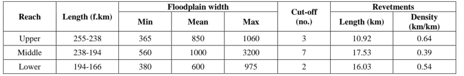
(166 f.km). Based on the degree of human impact and the morphological characteristics, the section was divided into three reaches (Table 1).
Along the Lower Tisza the pre-regulation slope (2.2 cm/km) was increased to 2.9 cm/km by artificial cut-offs.
The Maros River, which is the major tributary of the Ti- sza, has a high-slope (13 cm/km) in its lowland section, thus downstream of their confluence at Szeged the slope of the Tisza increases to 6 cm/km (Kiss et al., 2008; Mez- ősi, 2009). The Tisza in Hungary has a typical lowland river character, as it transports large amount of fine gra- ined sandy and silty suspended sediment and it has a cla- yey bed material (Lászlóffy, 1982; Mezősi, 2009; Kasse et al., 2010).
Fig. 1 The studied Tisza section was divided into three reaches based on the morphology of the channel. The studied cross- sections (1-upper reach; 2-middle reach; 3-lower reach) and
cut-offs are also indicated.
Table 1 Characteristics of the three river reaches evaluated in this study
Reach Length (f.km)
Floodplain width
Cut-off (no.)
Revetments
Min Mean Max Length (km) Density
(km/km)
Upper 255-238 365 850 1060 3 10.92 0.64
Middle 238-194 560 1000 3200 7 17.53 0.39
Lower 194-166 380 600 975 2 16.03 0.54
Hydrology
The catchment of the Tisza has an annual mean precipita- tion of 744 mm/y, thus the generated mean run-off is 177 mm/y (mean discharge: 830 m3/s; ICPDR, 2008). On the Tisza, usually two major floods occur. The first flood (MarchApril) is caused by snow melt, and if the snowmelt is combined with rainfall extremely large floods could develop. The second flood occurs during the summer (June), induced by the early summer rainfall. As the lowland section of the river is long, and its slope is small, this summer flood sometimes superimposes on the preceding spring flood, thus record high floods could develop. The absolute water level change between the highest and lowest water stages is 1355 cm at Mindszent (highest stage measured in 2006: 1062 cm; lowest stage measured in 1968: -293 cm), and 1184 cm at Szeged (hig- hest stage measured in 2006: 960 cm; lowest stage meas- ured in 1968: -224 cm). The discharge also shows consi- derable hydrological variations. At Szeged, the maximum discharge is 4348 m3/s (in 1932) and minimum value is 58 m3/s (in 2013; Lóczy et al., 2009; Kiss, 2014).
Regulation Works
The late 19th century marked the beginning of catchment- scale engineering interventions on the Tisza River. They involved the disconnection of the Tisza from its wetlands by construction of levees. The flood control levee-system is 2940 km long, and the originally 27000 km2 large natu- ral floodplain (which was about a third of the territory of Hungary) was reduced to 21251 km2. The aim of artificial levee constructions was to protect the land from inundati- ons and to provide safe areas for agriculture, and to dec- rease the duration of floods (Szlávik, 2000; Pinke, 2014).
Simultaneously, the river was shortened by 38% with 114 meander cut-offs (Dunka et al, 1996; Schweitzer, 2009).
As a result of cut-offs, the meandering equilibrium river was transformed into an in-growing meandering one, as its slope almost doubled (Kiss, 2014). The cut-offs accele- rated the erosion of the river bed, thus the sediment load increased, which resulted in accelerated deposition on the confined active floodplains (Kiss et al., 2011).
The regulation works in the 20th century continued by the construction of revetments and groynes. Revet- ments were built to stop the lateral erosion of bends which migrated too close to levees, whilst the groynes facilitated shipping by tightening wide sections and to train sharp bends in order to improve the flood con- ductivity of the river channel. In total 44% of the banks of the Tisza River were stabilized, mainly between the 1930s and 1960s. However, it started in 1886, whilst the latest was built in 2016.
The second half of the 20th century was the period of dam constructions on Tisza and its tributaries. On the Tisza, three dams (which operate as locks) were built at Tiszalök (1957) and Kisköre (1973) in Hungary, and Tö- rökbecse/Novi Becsej (1976) in Serbia (Bezdán, 2010).
The locks were built to impound the water during low stages, thus water withdrawal for irrigation could be se- cured, but they also produce hydropower and aid navi- gation. Although they are opened during floods, the
retention of sediments by the dam creates temporal se- diment deficit downstream which induces incision (Kiss et al., 2008; Lóczy et al., 2009).
Along the Lower Tisza channel regulations started in 1855, shortening the originally 131 km long studied ri- ver section by 30 km, cutting off 12 meanders. The origi- nally 6–8 km wide natural floodplain was reduced to 1 km in average. At Szeged however, the floodplain is just 400 m wide. The levees constricted the floodplain at some sections, thereby reducing its flood conductivity and inc- reasing the flood risk. Therefore, the height of levees was increased too: originally they were just 2.3–3.0 m high, but nowadays their height is 7.0 m, thus they could pro- vide safety despite of the increasing flood levels (Sipos et al., 2007; Kiss et al., 2008; Lóczy et al., 2009; Schweitzer, 2009). In the Lower Tisza 51.4% of the banks are pro- tected by revetments, but their spatial distribution is not even, as it is indicated by the different revetment density of the studied reaches (Table 1).
MATERIALS AND METHODS
To understand the channel depth changes caused by direct human impacts, the maximum and mean depths along cross-sectional profiles were measured and analyzed. The study employed a dataset of hydrological surveys made in 1891, 1931, 1961, 1976 and 1999. The Hydrological Atlas of the Lower Tisza (1974) provided the locations of the sur- veyed cross-sections and it also showed the bank lines of the river at different dates. The channel surveys were un- dertaken using fixed geodetic survey points (VO-stones) at approximate spacing of 2.5 km. These VO-stones allowed subsequent surveys at the same cross-sectional profiles at different times. Along a profile the channel depth was measured at 5 m intervals. In the present study relative depths were calculated from the bankfull level, which was determined as lowest point of the bank line (Fig. 2). Based on the cross-sectional profiles the maximum (thalweg) depth and the mean depth for every cross-section were de- termined. The maximum depth refers to the location of the thalweg. The mean depth was calculated as the arithmetic mean of all depth data of a cross-section.
Fig. 2 The depth values were measured from the bank- full level of a cross-section
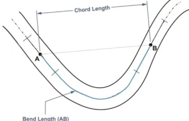
The spatial data of cut-offs and revetments were pro- vided by Hungarian Lower Tisza Water Directorate. In the study bends and meanders were distinguished, based on Laczay’s classification (Laczay, 1982). The sinuosity
of segments was calculated between two inflection points, as the ratio of bend length and chord length (Fig 3). If the sinuosity value was below 1.1, the segment was classified as a bend, if it was above 1.1 the segment was considered to be a meander.
Fig. 3 Determination of inflection points, bend length and chord length along the segments of the river
RESULTS AND DISCUSSION
The presented results include the changes in characteristic depths of the study section, the spatio-temporal variation of the thalweg, and its relative position to the nearest bank. The influence of the various human interventions was also evaluated by comparing the thalweg depth of channel segments influenced by direct and indirect human impact.
A general overview of the studied 36 cross-sections (Fig. 4) indicates that 64% of them are located in slightly sinuous bends, whilst the remaining 36% are situated in meanders. Also, ca. two-third of the cross-sections was under some kind of direct human influence, and only one- third (13) of them is free from direct engineering works, indicating heavy anthropogenic impact on the Lower Ti- sza River. The cross-sections free from any direct regu Changes in mean depth of the channel
The mean channel depth gives an indication of the general bed level change of a cross-section, and thus of the studied
segments and reaches. The yearly mean depth changes representative for the entire studied Lower Tisza, indicate incision for all periods (1891-1931: 1.4 cm/y; 1931-1961:
1.2 cm/y; 1961-1976: 0.6 cm/y; and 1976-1999: 1.6 cm/y). The intensive incision of the channel in the first period could be explained by the effect of the cut-offs. The incision continued in the next period (1931-1961) too, though the incision rate reduced by 14%, and this re- duction further continued but in a greater extent (50%) between 1961 and 1976. This general reduction in the mean depth of the whole section can be attributed to the gradual evolution of the channel after the first phase of the regulation works towards an equilibrium state. However, in the last period (1976-1999) the channel experienced its highest yearly incision rate. This could be explained by the construction of the revetments which restricted the la- teral erosion of the river. This meant the channel could undergo incision readily which resulted in higher incision rate by 1.5 times.
A more detailed analysis of the changes of the mean depth along the studied section (Fig. 5) shows that the location of the greatest incision rates changed by time. While between 1891 and 1931 the greatest in- cision (12 cm/y) appeared on the upper reach (VO 200), in the next period between 1931 and 1961, it was in the lower reach (10.5 cm/y, VO 225). Between 1961 and 1976, it was measured in the upper reach (14.1 cm/y, VO 207), and finally the incision rate was 9.5 cm/y bet- ween 1976 and 1999 which occurred in the middle reach (VO 214). The VO 200 probably incised in res- ponse to cut-offs since it is located within an artificial channel, however the remaining sections were all lo- cated within meanders. Although most cross-sections referred to incision, some cross-sections had higher in- cision rates. The period 1976-1999 had its highest aggradation (15.9 cm/y) in the middle reach. T he hig- hest rates of aggradation for all the other periods (1891- 1931: 8.7 cm/y; 1931-1961: 6.9 cm/y; and 1961-1976:
12.8 cm/y) occurred in the lower reach.
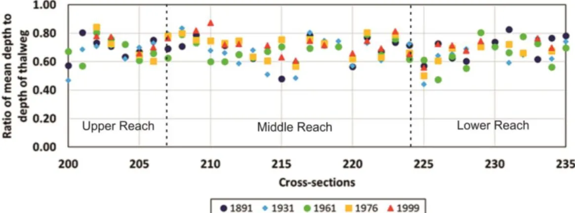
The ratio of the mean depth to the thalweg depth along the studied section of the river (Fig. 6) was also cal- culated, as it refers to the difference between the mean
Fig. 4 The studied cross-sections are located in meanders or bends, and various human interventions affected most of their deve- lopment
depth and the thalweg depth: smaller value indicates a greater difference between the thalweg depth and mean depth. The ratio of mean and thalweg depths generally decrease from upstream to downstream (0.70 for upper reach; 0.69 for middle reach; and 0.67 for lower reach), referring to a more even channel bottom towards downstream. However, consi- dering the temporal changes, it is interesting, that the ratio generally increases, referring to more intensive incision of the thalweg itself, than of the bottom of the whole channel.
Changes in the depth of the thalweg
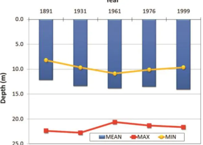
During the studied period the mean thalweg depth of the whole studied section increased from 12.2 m (1891) to 14.1 m (1999), thus by 15.5 %, representing an incision rate of 1.7 cm/y over a century and indicating a general thalweg incision (Fig. 7-9). However, the incision of the
thalweg was not temporally an even process, as at the be- ginning (1891-1931) the mean thalweg depth increased by 1.2 m which represents an incision rate of 3 cm/y. This incision continued (1931-1961), although its rate became lower (1.3 cm/y). Finally, between 1961 and 1976 the tha- lweg was subjected to aggradation resulting in the re- duction of the mean thalweg depth by 0.3 m (aggradation rate: 2 cm/y). This virtually negated the incision of the previous period. Between 1976 and 1999 the thalweg again experienced incision (2.3 cm/y). These changes could be explained by the human impacts on the studied section: the cut-offs which shortened the channel length caused an increase in bed slope, which resulted in stream power increase. The initial high incision rate could be att- ributed to the quest of the river to re-establish its equilib- rium after the cut-offs.
Fig. 5 Changes in mean depth: the mean depth at the beginning of a period between two surveys indicated by blue line; and the yearly change in mean depth in between survey years is indicated by red columns
Fig. 6 The variation of the ratio of the mean depth to thalweg along the studied section
Fig.7 Variations in mean thalweg depth for the whole studied section
As the channel gradually developed towards quasi-equilib- rium, the incision reduced (1931-1961), and the channel evo- lution process culminated in aggradation (1961-1976), simi- larly to the stages of the channel evolution model of Simon and Rinaldi (2006). The effect of high floods in the late 20th and early 21st centuries was combined with the effects of re- vetment and groin constructions, therefore the thalweg started to incise, thus the evolution model distorted. The range (i.e. the difference between the maximum and mini- mum thalweg depths) was up to 14.2 m in 1891. An increa- sing minimum thalweg depth and a decreasing maximum thalweg depth caused a reduction in the range until 1961. Af- terwards this trend reversed, thus the range increased (1999:
12 m) was still short of the 1891 value. This reduction in ran- ges points to the development of a uniform channel, implying that although the channel was progressing to equilibrium af- ter the cut-offs, the construction of the revetments and groy- nes initiated another cycle of dis-equilibrium.
Fig. 8 Variation of thalweg depth along the studied section for various survey years
The spatio-temporal changes of the thalweg were stu- died comparing the three reaches of the Lower Tisza. The upper and middle reaches show significant changes in tha- lweg depth, while in the lower reach the thalweg remained relatively stable (Fig. 8). This could be explained by (i) the ponding effect of the Danube and Maros Rivers on the Ti- sza (Vágás, 1982) and by (ii) the artificially more stabilized and straightened lower reach. The areas of maximum in- cision along the channel occur mainly downstream of the cut-offs. This means the scouring action of the increased
Fig. 9 Changes in thalweg depth: the thalweg depth at the beginning of a period between two surveys is indicated by red line, and the yearly change in thalweg depth in between survey years is indicated by blue columns
stream power was more pronounced at the end of the artifi- cial segments (cut-offs) of the river channel.
The location of the thalweg within the cross-sectional profile was studied in detail too: the greater the ratio bet- ween the location of the thalweg to the closest bank and the channel width, the farthest is the thalweg to the banks (Fig 10). Considering the whole, ca. 100 year-long period, it se- ems that the thalweg migrated closer to the banks in the up- per reach, whilst the changes within the middle reach are smaller, and in the lower reach the thalweg migrated away from the bank. The trends also show that the location of the thalweg had the greatest range of variations in the upper reach, referring to frequent thalweg changes: in some cross- sectional profiles the thalweg shifted almost across half of the channel width. Although along the middle reach at some cross-sections the thalweg shifts were very small, in general the lower reach had the narrowest range. This imp- lies the lower reach was more stable compared to the middle and upper reaches, although there were some very stable locations within the middle reach.
Fig. 10 Variation of the thalweg location relative to the whole cross-section width (the shaded area refers to the range of
changes in the position of the thalweg)
The mean thalweg depth values of the upper reach were generally lower than the whole section, and the de- epest thalweg depth was characteristic of the lower reach.
The incision of the thalweg depth of the three different reaches (Fig. 11) during the whole period reflects an inc- reasing trend towards downstream, as the mean depth of the thalweg increased by 1.3 m (1.2 cm/y) in the upper reach, by 1.7 m (1.6 cm/y) in the middle and 2.5 m (2.3 cm/y) in the lower reach.
Effect of human impacts on the evolution of the thalweg depth
To evaluate the role of engineering works on channel evo- lution, the channel segments not affected directly by cut- offs and revetments were compared to segments created by cut-offs and affected by revetments.
Effect of cut-offs
At the beginning, the mean thalweg depth in non cut-off segments was 11.7 m, while it was 13.7 m in artificial seg- ments (Fig. 12). The higher mean thalweg depth in the ar- tificial segments could be attributed to the initial scouring induced by the artificial channels of the cut-offs. Howe- ver, by 1999, the mean thalweg depth in the non cut-off segments had increased by 21% to 14.2 m (2.3 cm/y), while in case of artificial segments almost zero net change was recorded. With the exception of 1961-1976 when the channel experienced a general aggradation, there was consistent incision of the mean thalweg depth within the non cut-off segments. In the artificial segments, although there was no net change between 1891 and 1999, there was a depth increase of 0.9 m from 1891 to 1931 (2.2 cm/y), which was followed by a consistent reduction of mean thalweg depth (1931-1961: 1.3 cm/y; 1961-1976: 2 cm/y and 1976-1999: 0.9 cm/y). The incision within the non-cut-off segments are partly due to the construction of revetments (80% of revetments built in segments which were not created by cut-offs) which restricted the lateral erosion within the channel, and therefore increased
Fig. 12 Comparison of mean thalweg depths for cross-sections within segments affected and not affected by cut-offs, inc-
luding the range (maximum-minimum) of thalweg depths
Fig. 11 Variations in thalweg depth values within the various reaches
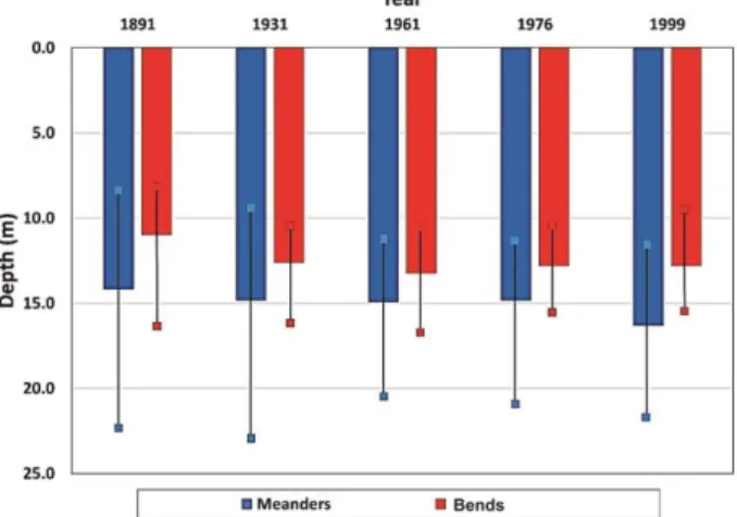
scouring of the channel bed to complement the se- diment deficiency. Another important factor is the location of a cross-section within a meander or bend. For an alluvial channel, due to the asymmetric nature of cross-sections in meanders, thalweg depths are generally deeper in meanders than in bends or straight segments (Dey, 2014). This state- ment is also valid for the Lower Tisza (Fig. 13), as the mean thalweg depth of meandering segments is deeper by 3 m than of the non-meandering segments. Within the studied section, more than 90% of the meanders are located in the non-cut-off segments which contributed to its depth incre- ments. However, the relatively narrower widths of the ar- tificial channels also meant that the channel had the ten- dency to scour with the initially high stream power.
Fig. 13 Comparison of mean thalweg depths for cross-sections within meanders and bends, including the range (maximum-mi-
nimum) of thalweg depths
The mean thalweg depth within the reaches fol- lowed similar trends as of the entire section for both the non cut-off and cut-off segments (Fig. 14-15) alt- hough the magnitude in the depth changes was diffe- rent. For the non cut-off segments, the upper reach had the least mean depths, and the lower reach had the highest magnitudes in mean thalweg depth. In case of artificial segments, decreasing temporal trends were found in the upper and middle reaches. However, in the lower reach, there was an increasing trend in mean thalweg depth values. Another important observation is the relatively larger ranges in the non cut -off seg- ments compared with the artificial segments.
Effect of revetments and groynes
When evaluating the effects of revetments and groy- nes in the development of the thalweg depth, it should not be forgotten, that only the combined effect of re- vetments, groynes and cut-offs could be studied, as they are located very close to each other, and also tem- porally the responses of the river on these inter- ventions overlap. The comparison of segments wit- hout any direct human impact to the artificially altered ones reflect very similar the trends, although the seg- ments with human impacts tend to have smaller ranges (Fig. 16). This is understandable due to the fa ct that they were artificially created, therefore more evenly engineered than the natural development of the non - affected channel segments. This creates more unifor- mity within the artificial segments compared to the natural channel segments.
Fig. 14 Variations of the mean thalweg depth within non cut-off segments
Fig.15 Variations of the mean thalweg depth within artificial segments created by cut-offs
Focusing on the reaches, the three reaches do not exhibit similar patterns (Fig. 17-18). The absence of clear trends shows the deficiency of generalization to responses of human impacts by rivers in some cases.
Fig. 16 Comparison of cross-sections with and without direct human impacts
CONCLUSION
The study analyzed the changes in mean depth and thalweg depth of the Lower Tisza River from 1891 to 1999, focusing on the role of direct human impacts (mainly regulation works) in their evolution. Simon and Rinaldi (2006) indicated that degradation of cha n- nel beds represents a response to a disturbance in which an excess of flow energy, shear stress or stream power (sediment-transporting capacity) occurs rela- tive to the amount of sediment supplied to the stream.
The results indicate that between 1891 and 1999, the mean depth of the channel increased as a response to human interventions and this is trend is similar to the response of rivers in Italy to various interventions with some incising by up to 10 m (Surian and Rinaldi, 2003). Using the periods in between the surveys as reference periods, the highest rate of incision occur- red immediately after human interventions, similarly to European and North American rivers, which also showed considerable adjustments immediately after human interventions (Smith and Winkley, 1996; Su- rian and Rinaldi, 2003). As a fluvial response on mid - and late-19th century cut-offs the incision accelerated in the period of 1891-1931, whilst the revetment and groynes constructions of the 1930-1960s increased further the channel depth between 1976 and 1999.
The evolution of the thalweg depth shows that in the periods of 1891-1931, 1931-1961 and 1976-1999, the channel experienced incision while during 1961 - 1976 it was characterized by aggradation. It marks the attainment of equilibrium before the river readjusted to the construction of revetments. The mean thalweg depths in the upper reach were lower than the mean for the entire section with the highest values referring to the lower reach. The mean depth of the thalweg ge- nerally increased from upstream to downstream.
Acknowledgements
The research was supported by the Stipendium Hungari- cum Programme and the Hungarian Research Foundation (OTKA 119193). Data were provided by the Water Di- rectorate of the Lower Tisza District (ATIVIZIG).
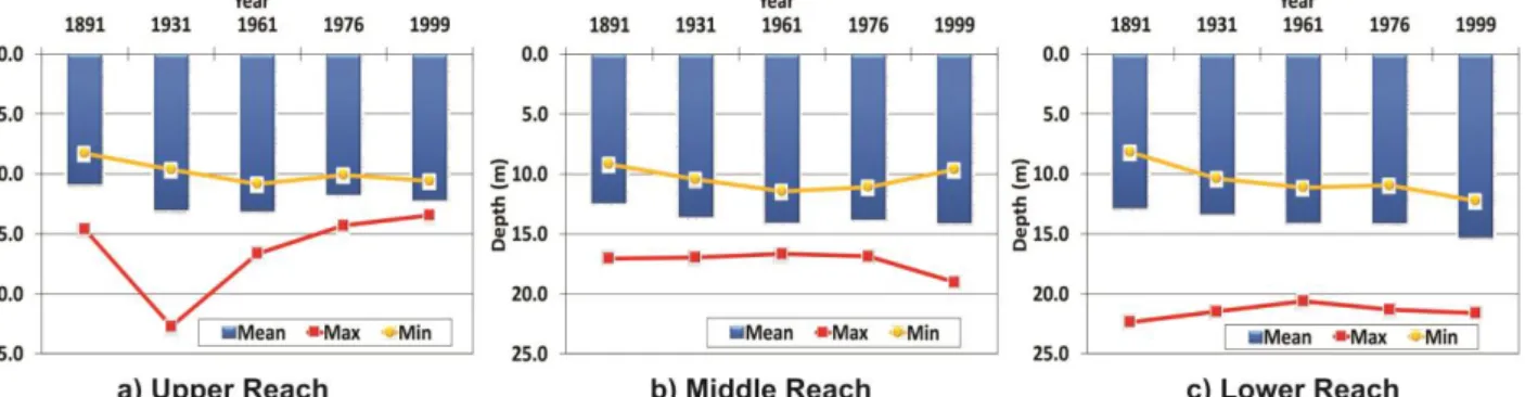
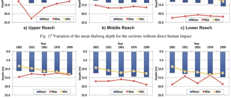
Fig. 17 Variation of the mean thalweg depth for the sections without direct human impact
Fig. 18 Variation of the mean thalweg depth for the sections with direct human impact
References
Anderson, R.S., Anderson, S.P. 2010. Geomorphology: The Mechanics and Chemistry of Landscapes. Cambridge University Press, UK, 340 p.
Antonelli, C., Provansal, M., Vella, C. 2004. Recent morphological channel changes in a deltaic environment. The case of the Rhone River, France. Geomorphology 57, 385–402. DOI: 10.1016/s0169- 555x(03)00167-3
Bezdan, M. 2010. Characteristics of the flow regime of the regulated Tisza River reach downstream of Tiszafüred. Journal of Env.
Geogr. 3 (1-4), 25 –30.
Bravard, J.P., Landon, N., Peiry, J.L., Piégay, H. 1999. Principles of engineering geomorphology for managing channel erosion and bedload transport, examples from French rivers. Geomorphology 31, 291 –311. DOI: 10.1016/s0169-555x(99)00091-4
Brierley, G.J., Fryirs, K.A. 2005. Geomorphology and River Manage- ment: Applications of the river styles framework. Blackwell Pub- lishing, UK, 398 p.
Chang, H.H. 2008. River Morphology and River Channel Changes.
Transactions of Tianjin Universities 14 (4), 254–262. DOI:
10.1007/s12209-008-0045-3
Church, M. 2006. Bed Material Transport and the Morphology of Allu- vial River Channels. Annual Review of Earth and Planetary Sci- ence 34, 325–354. DOI: 10.1146/annurev.earth.33.092203.122721 Dey, S. 2014: Fluvial Hydrodynamics. GeoPlanet Series, Springer-Ver-
lag, Berlin, 670 p.
Dunka, S., Fejér, L., Vágás, I. 1996. A verítékes honfoglalás: A Tisza szabályozás története. Vízügyi Múzeum és Levéltár, Budapest, 210 p. (in Hungarian)
Ferguson, R. 2010. Time to abandon the Manning equation? Earth Surf.
Proc. Landf. 38, 1873–1876. DOI: 10.1002/esp.2091
Fryirs, K.A., Brierley, G.J. 2001. Variability in sediment delivery and storage along river courses in Bega catchment, NSW, Australia:
implications for geomorphic recovery. Geomorphology 38, 237–
265. DOI_ 10.1016/s0169-555x(00)00093-3
Fryirs, K.A., Brierley, G.J., Preston, N.J., Kasai, M. 2007. Buffers, bar- riers and blankets: The (dis)connectivity of catchment-scale se- diment cascades. Catena 70, 49–67. DOI: 10.1016/j.ca- tena.2006.07.007
Fryirs, K.A., Brierley, G.J., Preston, N.J., Spencer, J. 2008. Catchment- scale (dis)connectivity in sediment flux in the upper Hunter catchment, New South Wales, Australia. Geomorphology 84 (3), 297–316. DOI: 10.1016/j.geomorph.2006.01.044
Harmar, O.P., Clifford, N.J., Thorne, C. R., Biedenharn, D. S. 2005.
Morphological changes of the Lower Mississippi River: Geo- morphological response to engineering intervention. River Rese- arch Applications 21 (10), 1107–1131. DOI: 10.1002/rra.887 Hooke, J.M. 1995. River channel adjustment to meander cutoffs on Ri-
ver Bollin and River Dane, Northwest England. Geomorphology 14, 235–253. DOI: 10.1016/0169-555x(95)00110-q
Huang, M.W., Liao, J.J., Pan, Y.W., Chen, M.H. 2014. Rapid channeli- zation aqnd incision into soft bedrock induced by human activity:
Implication from the Bachang River in Taiwan. Engineering Geo- logy 177, 10–24. DOI: 10.1016/j.enggeo.2014.05.002
International Commission for Protection of the Danube River (ICPDR).
2008. Analysis of the Tisza River Catchment 2007: Initial step to- wards the Tisza River Catchment Management Plan-2009. Vienna, Austria.
Kasse, C., Bohnake, S. J. P., Vandenberghe, J., Gabris, G. 2010. Fluvial style changes during the las glacial0interglacial transition in the middle Tisza Valley (Hungary). Proceedings of the Geologists As- sociation 121, 180–194. DOI: 10.1016/j.pgeola.2010.02.005 Kiss, T. 2014. Fluviális Folyamatok antropogén hatásra megváltozó di-
namikája: Egyensúly és érzékenység vizsgáta folyóvizi környezet- ben. Akadémiai doktori értekezés. Szeged, 165 p. (In Hungarian) Kiss, T., Balogh, M. 2015. Characteristics of point-bar development un- der the influence of a dam: Case study of the Dráva River at Sige- tec, Croatia. Journal of Env. Geogr. 8 (1-2), 23–30. DOI:
10.1515/jengeo-2015-0003
Kiss T., Fiala, K., Sipos, G. 2008. Alterations of channel parameters in response to river regulation works since 1840 on the Lower Tisza River (Hungary). Geomorphology 98, 96–110. DOI:
10.1016/j.geomorph.2007.02.027
Kondolf, G.M., Piégay, H., Landon, N. 2002. Channel response to inc- reased and decreased bedload supply from land use change: cont- rasts between two catchments. Geomorphology 45, 35–51. DOI:
10.1016/s0169-555x(01)00188-x
Kroes, D.E., Kraemer, T.F. 2013. Human-induced stream channel aban- donment/Capture and filling of floodplain channels within the Atchafalaya River Basin, Louisiana. Geomorphology 201, 148–
156. DOI: 10.1016/j.geomorph.2013.06.016
Laczay, I.A. 1982. A folyószabályozás tervezésének morfológiai alapjai.
Vízügyi Közlemények 64 (2), 235–256. (in Hungarian)
Landon, N., Piégay, H., Bravard, J.P. 1998. The Drȏme River incision (France): from assessment to management. Landscape and Urban Planning 43 (1-3), 119–131. DOI: 10.1016/s0169-2046(98)00046-2 Lászlóffy, W. 1982. A Tisza. Akadémiai Kiadó, Budapest. 610 p. (in
Hungarian)
Latapie, A., Camenen, B., Rodrigues, S., Paquier, A., Bouchard, J.P., Moatar, F. 2014. Assessing channel response of a long river influ- enced by human disturbance. Catena 121, 1–12. DOI:
10.1016/j.catena.2014.04.017
Legleiter, C.J. 2014. A geostatistical framework for quantifying the reach-scale spatial structure of river morphology: 2. Application to restored and natural channels. Geomorphology 205, 85–101. DOI:
10.1016/j.geomorph.2012.01.017
Liébault F., Piégay H. 2001. Assessment of channel changes due to long- term bedload supply decrease, Roubion River, France. Geo- morphology 36, 167–186. DOI: 10.1016/s0169-555x(00)00044-1 Liébault, F., Piégay, H. 2002. Causes of 20th century channel narrowing
in Mountain and Piedmont Rivers of southeastern France. Earth Surface Proc. and Landforms 27, 425–444. DOI: 10.1002/esp.328 Liébault, F., Gomez, B., Page, M., Marden, M., Peacock, D., Richard, D., Trotter, C.M. 2005. Land-use change, sediment production and channel response in upland regions. River Research and Applica- tions 21, 739–756. DOI: 10.1002/rra.880
Lóczy, D., Kis, É., Schweitzer, F. 2009. Local flood hazards assessed from channel morphometry along the Tisza River in Hungary.
Geomorphology 113, 200–209. DOI: 10.1016/j.geo- morph.2009.03.013
Mezősi, G. 2009. The Physical Geography of Hungary. Springer, Swit- zerland, 334 p.
Morais, E.S., Rocha, P.C., Hooke, J. 2016. Spatiotemporal variations in channel changes caused by cumulative factors in a meandering ri- ver: The lower Peixe River, Brazil. Geomorphology 273, 348–360.
DOI: 10.1016/j.geomorph.2016.07.026
Nagy, J., Kiss, T. 2016. Hydrological and morphological changes of the Lower Danube near Mohács, Hungary. Journal of Env. Geogr. 9 (1-2), 1–6.DOI: 10.1515/jengeo-2016-0001
Osei, N.A., Harvey, G.L., Gurnell, A.M. 2015. The early impact of large wood introduction on the morphology and sediment characteristics of a lowland river. Limnologica 54, 33–43. DOI:
10.1016/j.limno.2015.08.001
Pinke, Z. 2014. Modernization and Decline: an eco-historical perspective on regulation of the Tisza Valley, Hungary. Journal of Historical Geography 45, 92–105. DOI:
10.1016/j.jhg.2014.02.001
Pinter, A, Heine, RA. 2005. Hydrodynamic and morphodynamic res- ponse to river engineering documented by fixed-discharge analy- sis, Lower Missouri River, USA. Journal of Hydrology 302, 70–
91. DOI: 10.1016/j.jhydrol.2004.06.039
Powell, D.M. 2014. Flow resistance in gravel-bed Rivers: Progress in research. Earth Science Reviews 136, 301–338. DOI:
10.1016/j.earscirev.2014.06.001
Rinaldi, M. 2003. Recent channel adjustments in alluvial rivers of Tus- cany, Central Italy. Earth Surface Processes and Landforms 28, 587-608. DOI: 10.1002/esp.464
Rinaldi, M., Simon, A. 1998. Bed-level adjustments in the Arno River, Central Italy. Geomorphology 22, 57–71. DOI: 10.1016/s0169- 555x(97)00054-8
Rinaldi, M., Wyżga, B., Surian, N. 2005. Sediment mining in alluvial rivers: physical effects and management perspectives. River Rese- arch and Application 21, 805–828. DOI: 10.1002/rra.884 Schweitzer, F. 2009. Strategy or disaster: flood prevention related issues
and actions in the Tisza River Catchment. Hung. Geogr. Bull. 58, 3–17. DOI: 10.1007/978-94-011-4140-6_9
Simon, A, Rinaldi, M. 2006. Disturbance, stream incision, and channel evolution. The roles of excess transport capacity and boundary ma- terials in controlling channel response. Geomorphology 79 (3-4), 361–383. DOI: 10.1016/j.geomorph.2006.06.037
Sipos, G., Kiss, T., Fiala, K. 2007. Morphological alterations due to channelization along the lower Tisza and Maros Rivers (Hungary).
Geografia Fiscia E Dinamica Quaternia 30 (2), 239–247. DOI:
10.1016/j.geomorph.2007.02.027
Smith, L.M., Winkley, B.R. 1996. The response of the Lower Missis- sippi River to river engineering. Engineering Geology 45, 433–
455. DOI: 10.1016/s0013-7952(96)00025-7
Surian, A. 1999. Channel changes due to river regulation: the case of the Piave River, Italy. Earth Surface Processes Landforms 24, 1135–
1151. DOI: 10.1002/(sici)1096-9837(199911)24:12<1135::aid- esp40>3.3.co;2-6
Surian, N., Rinaldi, M. 2003. Morphological response to river engi- neering and management in alluvial channels in Italy. Geomorpho- logy 50, 307–326. DOI: 10.1016/s0169-555x(02)00219-2 Szlávik, L. 2000. Az Alföld árvízi veszélyeztetettsége. In: Pálfai, J (Ed.):
A víz szerepe és jelentősége. Nagyalföld Alapítvány, Békéscsaba, 64–84 (in Hungarian).
Vágás, I. 1982. A Tisza árvizei. VÍZDOK, Budapest, 283 p. (in Hunga- rian)
Van der Berg, J.H. 1995. Prediction of alluvial channel pattern of peren- nial rivers. Geomorphology 12, 259–279. DOI: 10.1016/01695- 55x9(50)0014v-
Wyżga, B. 2007. 20 A review on channel incision in Polish Carpathian Rivers during the 20th century. Developments in Earth Surface Processes 11, 525–553.DOI: 10.1016/s0928-2025(07)11142-1 Xu, J. 2002. River sedimentation and channel adjustment of the lower
Yellow River as influenced by low discharges and seasonal chan- nel dry-ups. Geomorphology 43, 151–164. DOI: 10.1016/s0169- 555x(01)00131-3
Yang, S.L., Milliman, J.D., Xu, K.H., Deng, B., Zhang, X.Y., Luo, X.X.
2014. Downstream sedimentary and geomorphic impacts of the Three Gorges Dam on the Yangtze River. Earth-Science Reviews 138, 469–486. DOI: 10.1016/j.earscirev.2014.07.006
Yates, R., Waldron, B., van Arsdale, R. 2003. Urban effects on flood plain natural hazards: Wolf River, Tennessee, USA. Engineering Geology 70, 1–15. DOI: 10.1016/s0013-7952(03)00088-7