western Hungary
Judit P. Barna, Brigitta Tóth, Emília Pásztor, Zita Mária Tokai, Katalin T. Biró, Sándor Puszta, István Eke, Adrián Puszta, János Busznyák, Napsugár Kocsis,
Beáta Tugya and Csilla Száraz
Introduction
This paper is an interim report on the initial fi ndings of a research project designed to ex- plore the prehistoric earthworks of Zala County in western Hungary. About thirty rondels and other complex structures of the Lengyel culture, seven of them in Zala County (BARNA et al. 2016), are known from western Hungary (Transdanu- bia) to date. The present study focuses on the non-invasive and multidisciplinary investiga- tion of one of these sites, the circular enclosure at Gétye-Gyomgyáló-lejtős. This site was dis- covered on an amateur aerial photo taken dur- ing an agricultural fl ight (Fig. 1).
The research project was designed and un- dertaken by a team made up of researchers from several Hungarian research institutes. Our research project focuses on the investigation of the earthworks, their location and setting in the landscape, their natural environment and their role in prehistoric settlement systems. Since we also consider the sky as an integral part of the natural environment, one of our goals is the analysis of how rondels are aligned in relation to the celestial bodies or phenomena. The au- thors of this paper have addressed the problems of the defi nition, designation, function, distribu- tion, origin, and orientation of rondels in several studies (BARNA/PÁSZTOR 2011; PÁSZTOR/BARNA/ ZOTTI 2014; BARNA et al. 2015; BARNA et al. 2016).
Rondels: History of research in Zala County
Since the discovery of the fi rst Neolithic ron- del in Hungary at Sé (Vas County) in the 1970s
(KÁROLYI 1983–84), about thirty rondels and other complex structures of the Lengyel culture have been identifi ed in western Hungary to date (BARNA et al. 2016, Table 1; BERTÓK/GÁTI 2011;
2014). The exact number of Late Neolithic ron- dels cannot be determined in the lack of exact dates. The Late Neolithic period in Transdanu- bia is spanned by the early and classical phase of the Lengyel culture (KALICZ 1988) according to the Hungarian terminology.
Seven circular earthworks of the Lengyel cul- ture, whose majority are rondels, have been dis- covered at six sites in Zala County (Fig. 2.1–7), including the two enclosures at Sormás-Török- földek. Over one-half of the currently known sites lie in the Zalapáti Ridge micro-region.
These include a rondel with a single ditch (Gétye-Gyomgyáló-lejtős) and a triple rondel (Nagykanizsa-Palin, Anyagnyerőhely). Four double enclosures have been identifi ed to date (Sormás-Török-földek I and II, Bezeréd-Teleki- dűlő II, and Balatonmagyaród-Hídvégpuszta).
Field surveys were carried out on all of these sites. The exact ground plan of the assumed rondel at Becsehely-Gesztenyési-földek remains uncertain as it is only known from aerial pho- tographs, while smaller or larger excavations have been conducted on the other sites (Sormás- Török-földek: BARNA 2007; BARNA/PÁSZTOR 2011;
Nagykanizsa-Palin, Anyagnyerőhely: TOKAI
2008; Balatonmagyaród-Hídvégpuszta: BÁNFFY 1992; 1996). The sites at Bezeréd-Teleki-dűlő II and Gétye-Gyomgyáló-lejtős were also investi- gated by geomagnetic surveys.
History of research on the site
This site was discovered on an amateur aerial photo taken during an agricultural fl ight (Fig. 1) and then reported to the researchers of the Balaton Museum by an amateur collector.
Our research team decided to gather as much information about the site as possible using non-invasive methods. First, in order to clarify the age of the site from surface fi nds, we con- ducted two fi eld surveys in July and December 2011 before the geomagnetic survey, which was fi rst undertaken in March 2012. The results of the fi rst geomagnetic survey, which revealed approximately one-half of the rondel’s ground plan, were published in a short preliminary re- port (BARNA et al. 2012).
Another geomagnetic survey was carried out in November 2012 with the goal of mapping the entire ground plan of the rondel. This survey ended with partial success: although the pre- viously missing part of the ground plan of the rondel could be measured and we obtained a clear outline of the enclosure, the GPS measure- ments of the height data were unsuccessful and, as a consequence, the digital elevation model of the site and the rondel could not be prepared. In
order to remedy this situation, another survey was undertaken to repeat the measurements of the height data in September 2014. The pedo- logical analysis was performed in August 2015.
Two soil profi les were described in the fi eld, while the chemical and physical properties of the soil samples collected from the profi les and from augerings at eight locations were further examined in a laboratory.
Geographical description of the site
The site of Gétye-Gyomgyáló-lejtős lies in Zala County, 13 km west of Keszthely. It is located on the northern part of the Zalaapáti Ridge, in the catchment of the Zala River. The site was selected for a geomagnetic survey based on several factors such as previously col- lected information (aerial and satellite photos), its geographical location and natural environ- ment. The rondel is also clearly visible on an ar- chive aerial photo taken for military purposes in the 1960s (Fig. 3).
The geomagnetic survey was undertaken in order to gather further data, fi rst of all on the layout (ground plan) of the feature, which would help in clarifying the function of the en- Fig. 1 Amateur aerial photo of the rondel at Gétye-Gyomgyáló-lejtős.
closure identifi ed on aerial and satellite photos.
The Gétye rondel lies in the Zala Hills of Zala County in western Hungary (latitude 46°45’4.65”N, longitude 17° 4’4.71”E). The ar- ea’s topography is characterised by eroded val- leys oriented towards north and south, its mean elevation is 171 m. The top and the slopes of the hills are eroded, the mean relief is 61 m2/km.
Yearly average precipitation is between 700 and 750 mm, the mean temperature is 10 °C. The geology of the area is characterised by young, Tertiary, clayey or sandy sediments (Pannonian deposition), Pleistocene loess deposited on the Cretaceous and Triassic rocks rich in calcium carbonate, and on metamorphic rocks from the Devonian and the Silurian period. The main land use type is arable farming, fruit trees and forests (MAROSI/SOMOGYI 1990, 463).
The Zalaapáti Ridge is a 5–12-kilometre wide, weathered, fl at-topped hill that runs lengthways from north to south between the
Principális Channel and the lower course of the Zala River. Its surface is remarkably complex.
This is the most extensive micro-region in the eastern Zala Hills. The typical soil type in the northern part of the Zalaapáti Ridge is Luvisol (IUSS Working Group WRB 2014) that evolved on loess slopes (MAROSI/SOMOGYI 1990, 463).
The rondel at Gétye-Gyomgyáló-lejtős is located partly on the eastern slope of a north to south oriented hill and partly on a plateau whose height is ca. 170 m a.s.l. Owing to its lo- cation, its eastern side is distorted on account of the terrain where it was constructed, the re- sult being an irregular oval ground plan instead of a regular circle. Here, on the eastern side of the hill, the slope descends steeply to the val- ley of the Csuhi Stream, which fl ows into the Zalaapáti Stream at a distance of ca. 500 metres south, south-east of the site. Similarly to all the streams fl owing in the northern part of the Za- laapáti Ridge, the water of Zalaapáti Stream is collected by the Zala River.
Traces of an extensive Neolithic settlement were identifi ed at Gétye-Káptalan út on the other side of the valley of the Csuhi Stream during a fi eld survey in 2011. The site lies east of the rondel. The settlement, which had pos- sibly been occupied during the rondel’s active use, can perhaps be identifi ed with this site, but this assumption still needs to be confi rmed. The Neolithic site at Gétye-Káptalan út is bordered
Fig. 3 Archive aerial photo taken for military purposes showing the surroundings of the site at
Gétye-Gyomgyáló-lejtős, 14.05.1964.
Fig. 2 The Late Neolithic rondels of Zala County:
1 Becsehely-Gesztenyési-földek; 2 Sormás-Török- földek; 3 Nagykanizsa-Palin, Anyagnyerő-hely;
4 Balatonmagyaród-Hídvég-puszta; 5 Gétye- Gyomgyáló-lejtős; 6 Ligetfalva-Gesztenyési-dűlő;
7 Bezeréd-Teleki-dűlő II.
0 20 km
by the Csuhi Stream from the south and the west, and by the Zalaapáti Stream from the east.
The southern end of the hill extends into the val- leys of both streams like a peninsula. The hill top rises signifi cantly above its surroundings and offers a splendid view and a strategically excellent position.
The rondel at Gétye-Gyomgyáló-lejtős:
Orientation and location of the rondel
The Gétye rondel consists of a single, oval ditch (Figs 4–5) with a V-shaped cross-section as can be seen on the graphic representation depicting the magnetic anomalies as negative heights (Fig. 5). The four gates interrupting the ditch have their axes oriented 66°, 141°, 255°, and 333° of north, respectively. Its diameter is
about 96 m x 115 m, making it a medium-sized rondel compared to the other ones. The low number of magnetic anomalies and the scatter and position of the Neolithic surface fi nds indi- cate a handful of settlement features both inside and outside the rondel. There were no recognis- able trace of a palisade. The higher anomalies in the “gate” areas of the ditch – except at the eastern gate – are noteworthy because they per- haps indicate the remains of burnt wooden gate constructions or of charcoal and burnt daub re- mains from ritual activities.
The location of the Gétye rondel in the land- scape can be regarded as typical. The selection of the rondel’s location in the geographical surroundings was most likely principally de- termined by the choice of settlement locations.
Also, additional functional considerations such Fig. 4 The processed magnetic map of the rondel
shown with a blue-yellow-red colour scale. Fig. 5 The assumed source of magnetic anomalies shown on a map.
as the alignment or maintenance of the earth- work as well as various dimensions of beliefs such as the ones relating to the sun may also have played a role. It has been recently argued that topographic conditions and slope direction may also have infl uenced the location of the earthworks and the orientation of their gates (ZOTTI/NEUBAUER 2015; PÁSZTOR/BARNA/ZOTTI
2014). The orientation of the eastern “gates” of the rondels refl ects a conscious and deliberate choice, which was no doubt motivated by the belief system (PÁSZTOR/BARNA/ROSLUND 2008).
The analysis of the alignments of nineteen sites for which data is currently available in Transdanubia (BARNA et al. 2015) seems to sup- port our previously published contention that the eastern gates were oriented toward the posi- tion of the rising sun on the horizon (PÁSZTOR/ BARNA/ROSLUND 2008; PÁSZTOR/BARNA/ZOTTI
2014). The orientations of the gates on the east- ern side of the rondels not only fall within the rising sun arc on the horizon, but they also fall within a narrow range (± 5% to due east) which refl ects a common principle behind the architec- tural features and, possibly, shared foundation rites (BARNA et al. 2015, Fig. 10) (Fig. 6). The clus- tering in the alignment data may indicate the strict and coherent adherence to this principle ruling alignment. At the same time, it seems to be irrelevant in terms of the chronological position of a particular site within the Lengyel culture since the same practice can be traced in different phases of this culture. A high degree of uniformity in the architectural design of ron- dels is attested among the ditch systems of the Lengyel culture in the western (Transdanubian) half of the Carpathian Basin, in south-western Slovakia and in eastern Austria (ZALAI-GAÁL Fig. 6 The orientation values of the gates on the eastern side of circular enclosures (rondels) investigated in
Transdanubia.
1990, 20). Our assumption is that this uniform- ity can be demonstrated in the alignment of the eastern gates, in the principle of how to set the direction of these gates, as well as in how to construct the others, that is, in the materialised form of the very “concept of the rondel”.
This principle and ideology was observed in the later phases of development in Transdanu- bia, which is part of the formation territory both of the Lengyel culture and of the rondels (BAR-
NA/PÁSZTOR 2011). This principle in founder ori- entation also survived into later times, when the layout and structure of rondels had undergone considerable change and deformation.
From our detailed analysis of the alignment data of the Gétye rondel, we concluded that the relief conditions may have resulted not only in the distorted oval ground plan, but also in some bias of the direction set out during the align- ment procedure. The extreme alignment data of the Gétye rondel can be clearly seen in Figure 6.
GIS measurements
We needed a fi eld equipment capable of phase measurement for the high-precision GPS measurement. We used a Trimble 5800 receiver
with the TSC2 survey controller version 12.22.
There was no possibility to receive online re- fi nement data during the terrain measurements.
During the post-processing of the GPS data gained from the kinematic terrain measurement, we used the data collected by the GNSS (Global Navigation Satellite System – GPS, GLONASS) Base Station of the Georgikon Faculty, Univer- sity of Pannonia, Hungary. The optimal short base vectors (well under 30 km) were suitable for geodesic accuracy (cm). The GPS data ex- ported to a RINEX (Receiver Independent Ex- change Format) format were used with the help of the TBC (Trimble Business Center version 2.6) processing software to meet the base data.
We chose the EOV1 (1972) Hungarian coordi- nate system for our data, which is offi cially and widely used in Hungary. The elevation cut and the frequency of procession of observation were, similarly to the terrain measurement settings, 10 degrees and 10 seconds. Vertical and horizon- tal accuracy requirements were set to the usual 0.1m + 1ppm and 0.2m + 1ppm (ppm – part per million). Thus, the processed vectors of several
1 Egységes Országos Vetületi Rendszer = National Uniform Projection System.
Fig. 7 The location of soil profi les (TSZ1 and TSZ2) and soil augering points (F01-F08) shown on the magnetometer plot.
0 50 m
kinematic measurements were altogether 15849 in Gétye, Hungary.
Several problems had to be solved during the collection of the coordination information used for the magnetometer measurement. First, while performing the measurements, the tools had to be synchronised in time and space. Because of local circumstances, a continuous GPRS connec- tion was not accessible (appropriate accuracy radio and satellite refi nement was not possi- ble), and thus only the post-processing of the GPS data could be applied. Measurements were carried out in three stages. Terrain positioning was used twice for the magnetometric measure- ments, and once for the validation and accuracy refi nement of previously obtained data. The latter was necessary because of the uncertainty caused by the short initialisation time during the post-processing of the second set of meas- urements. These measurements ensured that we could work with a geodesic accuracy model.
Geophysical survey
The extent of the examined area was 180 m × 160 m. We took magnetic measurements on the
points of a 0.5 m × 1.0 m grid. We collected over 30,000 magnetic data, from which we computed a map.
We used a GSM-19 (Overhauser) magne- tometer by GEM Systems for measuring the magnetic induction in horizontal variometer arrangement. This involves a parallel data col- lecting with a moving magnetometer and a base magnetometer. The navigation was performed by the “GPS tracking” method. In this case, the two units (GPS and MAG) were at a constant distance from each other in order to minimise the magnetic disturbance of the GPS. The co- ordinates of each point were treated as data of sub-meter accuracy.
During the processing, we analysed the properties of the data in the fi eld and frequency domain, and chose the optimal processing pa- rameters. The following steps were performed during data processing: measurement noise re- duction; base correction; dynamic compression;
interpolation of the data; fi ltering of the mag- netic maps; extrapolation of the data; calcula- tion of the two-dimensional Fourier spectrum;
calculation of the radial power spectra; low pass fi ltering of the data; direction dependent fi lter- Fig. 8 Texture and calcium carbonate content of augered soil profi les (TSZ1 and TSZ2).
Fig. 9 Location, calcium carbonate content and texture of augered soil samples 5 m southwest from the centreline of the ditch’s west and east gate (F01-F06).
Point
ID Horizon symbol Depth
(cm) Colour
Plasticity according to Arany
(m%)
Hygro- scopicity
(m%)
Texture based on hygro-
scopicity
Or- ganic carbon (m%)*
Or- ganic matter
(m%)
CaCO3
(m%) PHH2O PHKCl Total P (mg/
kg)
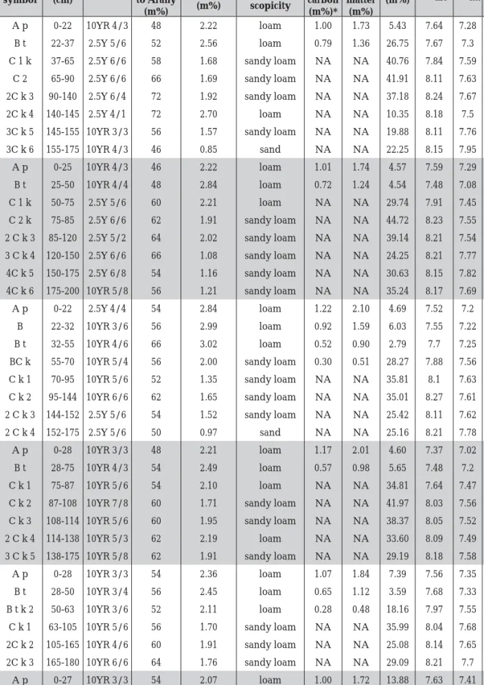
F01 A p 0-22 10YR 4/3 48 2.22 loam 1.00 1.73 5.43 7.64 7.28 1184
B t 22-37 2.5Y 5/6 52 2.56 loam 0.79 1.36 26.75 7.67 7.3 1142
C 1 k 37-65 2.5Y 6/6 58 1.68 sandy loam NA NA 40.76 7.84 7.59 634
C 2 65-90 2.5Y 6/6 66 1.69 sandy loam NA NA 41.91 8.11 7.63 559
2C k 3 90-140 2.5Y 6/4 72 1.92 sandy loam NA NA 37.18 8.24 7.67 539
2C k 4 140-145 2.5Y 4/1 72 2.70 loam NA NA 10.35 8.18 7.5 678
3C k 5 145-155 10YR 3/3 56 1.57 sandy loam NA NA 19.88 8.11 7.76 982
3C k 6 155-175 10YR 4/3 46 0.85 sand NA NA 22.25 8.15 7.95 1645
F02 A p 0-25 10YR 4/3 46 2.22 loam 1.01 1.74 4.57 7.59 7.29 1297
B t 25-50 10YR 4/4 48 2.84 loam 0.72 1.24 4.54 7.48 7.08 1006
C 1 k 50-75 2.5Y 5/6 60 2.21 loam NA NA 29.74 7.91 7.45 669
C 2 k 75-85 2.5Y 6/6 62 1.91 sandy loam NA NA 44.72 8.23 7.55 547 2 C k 3 85-120 2.5Y 5/2 64 2.02 sandy loam NA NA 39.14 8.21 7.54 536 3 C k 4 120-150 2.5Y 6/6 66 1.08 sandy loam NA NA 24.25 8.21 7.77 782 4C k 5 150-175 2.5Y 6/8 54 1.16 sandy loam NA NA 30.63 8.15 7.82 592 4C k 6 175-200 10YR 5/8 56 1.21 sandy loam NA NA 35.24 8.17 7.69 616
F03 A p 0-22 2.5Y 4/4 54 2.84 loam 1.22 2.10 4.69 7.52 7.2 1101
B 22-32 10YR 3/6 56 2.99 loam 0.92 1.59 6.03 7.55 7.22 952
B t 32-55 10YR 4/6 66 3.02 loam 0.52 0.90 2.79 7.7 7.25 973
BC k 55-70 10YR 5/4 56 2.00 sandy loam 0.30 0.51 28.27 7.88 7.56 904 C k 1 70-95 10YR 5/6 52 1.35 sandy loam NA NA 35.81 8.1 7.63 1175 C k 2 95-144 10YR 6/6 62 1.65 sandy loam NA NA 35.01 8.27 7.61 541 2 C k 3 144-152 2.5Y 5/6 54 1.52 sandy loam NA NA 25.42 8.11 7.62 1488
2 C k 4 152-175 2.5Y 5/6 50 0.97 sand NA NA 25.16 8.21 7.78 750
F04 A p 0-28 10YR 3/3 48 2.21 loam 1.17 2.01 4.60 7.37 7.02 979
B t 28-75 10YR 4/3 54 2.49 loam 0.57 0.98 5.65 7.48 7.2 1056
C k 1 75-87 10YR 5/6 54 2.10 loam NA NA 34.81 7.64 7.47 1273
C k 2 87-108 10YR 7/8 60 1.71 sandy loam NA NA 41.97 8.03 7.56 815 C k 3 108-114 10YR 5/6 60 1.95 sandy loam NA NA 38.37 8.05 7.52 663
2 C k 4 114-138 10YR 5/3 62 2.19 loam NA NA 33.60 8.09 7.49 506
3 C k 5 138-175 10YR 5/8 62 1.91 sandy loam NA NA 29.19 8.18 7.58 613
F05 A p 0-28 10YR 3/3 54 2.36 loam 1.07 1.84 7.39 7.56 7.35 1068
B t 28-50 10YR 3/4 56 2.45 loam 0.65 1.12 3.59 7.68 7.33 1113
B t k 2 50-63 10YR 3/6 52 2.11 loam 0.28 0.48 18.16 7.97 7.55 1916 C k 1 63-105 10YR 5/6 56 1.70 sandy loam NA NA 35.99 8.04 7.68 756 2C k 2 105-165 10YR 4/6 60 1.91 sandy loam NA NA 25.08 8.14 7.65 465 2C k 3 165-180 10YR 6/6 64 1.76 sandy loam NA NA 29.09 8.21 7.7 336
F06 A p 0-27 10YR 3/3 54 2.07 loam 1.00 1.72 13.88 7.63 7.41 531
C k 1 27-70 10YR 5/6 56 1.84 sandy loam NA NA 35.18 7.97 7.58 379 2C k 2 70-90 10YR 5/8 52 1.82 sandy loam NA NA 22.85 8.06 7.64 301
3C k 3 90-100 10YR 6/6 58 2.58 loam NA NA 30.04 8.12 7.55 281
Table 1 (part 1) Physical and chemical properties of soil horizons collected for the analysis of the Gétye ditch.
ing of the data; downward continuation of the data; reduction to the pole; optimum (Wiener) smoothing fi ltering; phase only map; coherence enhancement.
The processed magnetic map is shown by a blue-yellow-red colour scale (Fig. 4).
The second map shows the assumed source of the magnetic anomalies. In our view, the anomalies refl ect the material of infi lled pits or ditches (Fig. 5).
Pedological analysis
The aim of the pedological analysis was to confi rm the fi ndings of the archaeological re- search in terms of soil formation processes and to predict the probable depth of the prehistoric soil surface at the time the Gétye rondel was constructed.
The most characteristic soil type around Gé- tye is Luvisol (IUSS WORKING GROUP WRB 2014) Table 1 (part 2) Physical and chemical properties of soil horizons collected for the analysis of the Gétye ditch.
a Organic carbon content was analysed for topsoils and subsoils.
b Organic matter content was calculated assuming that it has 58% organic carbon content.
Point
ID Horizon symbol Depth
(cm) Colour
Plasticity according to Arany
(m%)
Hygro- scopicity
(m%)
Texture based on hygro-
scopicity
Or- ganic carbon (m%)*
Or- ganic matter
(m%)
CaCO3
(m%) PHH2O PHKCl Total P (mg/
kg)
F06 3C k 4 100-150 2.5Y 6/6 58 2.29 loam NA NA 22.55 8.21 7.64 244
3C k 5 150-190 2.5Y 5/4 70 1.97 sandy loam NA NA 35.69 8.19 7.73 376
F07 A p 0-25 2.5Y 3/2 52 2.47 loam 1.22 2.11 6.24 7.62 7.32 881
B 25-30 10YR 3/3 50 2.43 loam 1.22 2.10 10.36 7.69 7.31 866
C k 1 30-50 10YR 3/1 56 1.42 sandy loam NA NA 39.35 7.86 7.61 453
2C k 2 50-95 10YR 3/6 48 0.71 sand NA NA 27.49 8.02 7.8 496
2C k 3 95-120 10YR 5/6 46 0.81 sand NA NA 21.12 8.14 7.91 470
3C k 4 120-150 2.5Y 5/6 72 1.79 sandy loam NA NA 36.10 8.14 7.7 663
F08 A p 0-22 10YR 3/4 52 2.26 loam 1.20 2.06 12.92 7.79 7.32 909
B t 22-30 10YR 3/3 56 2.30 loam 1.07 1.85 14.95 7.67 7.39 866
C k 1 30-45 10YR 5/6 60 1.84 sandy loam NA NA 34.90 7.76 7.53 350
2C k 2 45-60 10YR 5/1 74 2.46 loam NA NA 33.54 8.02 7.44 232
3C k 3 60-105 10YR 3/2 48 1.01 sand NA NA 24.37 8.13 7.79 915
4C k 4 105-115 10YR 4/3 66 1.76 sandy loam NA NA 29.25 8.2 7.65 688 4C k 5 115-145 10YR 4/4 66 1.67 sandy loam NA NA 24.69 7.99 7.56 439
TSZ1 A p 0-25 10YR 4/4 60 2.52 loam 0.82 1.41 6.21 7.68 7.61 792
B t 25-60 10YR 3/4 60 2.71 loam 0.56 0.97 4.26 7.71 7.33 947
C k 1 70-80 10YR 4/4 50 2.05 loam NA NA 26.50 8 7.65 643
C k 1 100-110 10YR 4/6 50 1.78 sandy loam NA NA 26.79 8.13 7.72 1030 C k 1 130-140 10YR 4/4 52 1.86 sandy loam NA NA 28.04 8.18 7.69 436 C k 1 160-170 10YR 4/4 52 1.71 sandy loam NA NA 27.66 8.15 7.7 605 C k 1 190-200 10YR 4/4 60 1.73 sandy loam NA NA 25.59 8.07 7.67 1004 2C k 2 210-230 10YR 4/3 54 1.22 sandy loam NA NA 21.83 8.1 7.7 556
TSZ2 A p 0-28 10YR 3/4 50 2.45 loam 1.21 2.09 16.12 8.09 7.28 591
C k 1 28-40 10YR 4/6 48 1.45 sandy loam NA NA 37.64 7.81 7.58 278 2C k 2 40-85 10YR 4/4 50 1.37 sandy loam NA NA 34.91 8.08 7.59 674
3C k 3 85-105 10YR 4/3 50 0.82 sand NA NA 21.45 8.19 7.69 410
developed on loess parent material, which is eroded on the hillslope areas (DÖVÉNYI 2010).
We analysed two soil profi les and augered samples taken from eight points. We used the results of the magnetometer analysis when se- lecting the soil sampling locations (BARNA et al.
2012). We analysed two soil profi les for confi rm- ing the presence of the infi lled ditch. One was taken from the fi ll of the rondel’s ditch (TSZ1), the other from a point outside the ditch (TSZ2), where the magnetometer analysis did not indi- cate any disturbances.
We also analysed the differences in soil de- velopment caused by the slope in order to un- derstand where the prehistoric soil surface was at the time the rondel was constructed. We col- lected augered samples at eight points: six au- gerings were made 5 m south-west of the im- aginary centreline between the rondel’s western and eastern gate (F01–F06) and two were made along a line towards the north that was perpen-
dicular to the imaginary centreline (F07 and F08) (Fig. 7).
The distribution of soil properties according to soil depth was analysed in R statistics (R CORE TEAM 2013).
We described the soil profi les in the fi eld.
Soil horizons were also distinguished for the au- gered samples. In the case of F01-F08 and TSZ2, we collected samples from each soil horizons.
In order to better understand the ditch’s infi ll- ing, we sampled horizon C of the TSZ1 profi le at every 30 cm with 10 cm depth interval.
We analysed the Munsell colour of wet sam- ples, the soil texture based on hygroscopicity (MSZ-08-0205-1978) and plasticity (MSZ-21470- 51-1983), organic carbon content (TYURIN 1931), calcium carbonate content (NELSON 1982), pH in water and potassium chloride in a 1:2.5 soil wa- ter/solution ratio (MCLEAN 1982) and total phos- phate content (modifi ed MURPHY/RILEY 1962) in the laboratory after PETŐ et al. (2012; 2015).
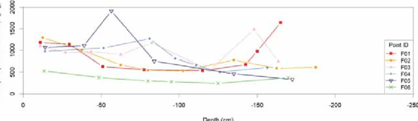
Fig. 10 Total phosphate content of soil samples inside and outside the Gétye rondel (F01–F06).
Fig. 11 Total phosphate content of soils samples inside and outside the Gétye rondel (F07–F08, TSZ1–TSZ2).
Results of the pedological analyses
The depth of the soil – the depth of horizons A and B – changed due to the topography (Fig.
8; Table 1). Soil depth increased towards the east along the imaginary centreline between the ditch’s western and eastern gate (F01-F05) (Fig. 9). We can assume that the soil profi les in which horizon C starts within 50 cm are eroded because the average depth of the non-eroded Luvisol varied between 50 and 100 cm in this area. Despite the high precipitation and lower evaporation rates that characterise this region, the presence of high amounts of calcium car- bonate (4.6–16.1%) in the topsoil (Fig. 9) in- dicate that there was no eluviation of calcium carbonate, which is characteristic in this region.
The lack of eluviation might have been caused by a decrease in the amount of water infi ltrat- ing the soil due to the relief, which increases the amount of runoff water. Another reason could be the continuous erosion of the soil surface.
The distribution of the calcium carbonate content in TSZ1 quite clearly differs from all the other points (F01-08 and TSZ2), confi rming that this soil profi le represents the fi ll of the rondel because the original horizonation with a differ- ent calcium carbonate content was more or less homogenised due to their mixing during the construction of the rondel and later on, during the infi lling as well.
As a result of weak eluviation, we did not fi nd any clay migration either. Some clay migra- tion could only be noted in F01-F05 and TSZ1, refl ected by the slight increase of hygroscopic values (Table 1).
The texture of the horizon of point F06 and its chemical properties such as calcium car- bonate (Fig. 9) and phosphate content (Fig. 10) differ slightly from the other augered points (Table 1), which could be due to its greater prox- imity to the Csuhi Stream. At the F06 point, fl u- vial sediments had a dominant impact on soil profi le development.
Fig. 12 Scatter and position of the Neolithic surface fi nds inside and outside the rondel.
0 50 m
The total P content of the Hungarian culti- vated topsoils varies between 20 and 1400 mg/
kg (GYŐRY 1984); according to FÜLEKY (1983), to- tal P content is under 1000 mg/kg in most cases.
Phosphate is not mobile in the soil (TROEH/ THOMPSON 2005), and therefore the amount originating from fertilisation can increase soil P content up to 30 cm depth. It can be mechani- cally moved down into deeper layers if deep ploughing is applied, but in that case, P content is homogeneously increased in the entire culti- vated layer, which is 60 cm deep at most. Among the analysed soil samples, total P content varied
between 232 and 1916 mg/kg, its mean value was 752 mg/kg (Figs 10–11). Between 50 and 100 cm, total P content had a fi rst peak in F03, F04, F05 and TSZ1. In the case of F01 and F03, there is a second peak at a depth of ca. 150 cm.
PETŐ et al. (2010; 2012) found a total P content of 1105–1325 mg/kg in the paleosoils of the Lyukas-halom kurgan and of 1456–1941 mg/kg at the Győr–Ménfőcsanak-Szélesföldek archae- ological site in the prehistoric soil surface layer, which might be of anthropogenic origin other than fertilisation.
Fig. 13 Layers of the soil profi le No 1 (TSZ1) and its fi nds.
0 1m
1 2
4 3
5
6
7
8
9
10
11
12
14 13
I
II
III
IV
V
10 mm
charcoal fragments fragments of wattle-and-daub pot sherds stone
0
10 mm
0 0 10 mm
10 mm 0
10 mm 0
10 mm 0
10 mm 0
10 mm 0
10 mm 0 10 mm
0
10 mm 0
10 mm 0
10 mm 0
10 mm 0
Conclusions drawn from the pedological analyses
The chemical soil analyses indicated a higher amount of total phosphate content in the hori- zons lying deeper than 60 cm, implying that this high amount of phosphate cannot be attributed to fertilisation, but to some other human impact.
It seems likely that a high number of bones were deposited during the use of the ditch (PETŐ et al.
2012).
The distribution of calcium carbonate con- tent and hygroscopicity values, and the joint depth of horizons A and B indicated that the pedological development of the two studied soil profi les – one outside the ditch, the other in the fi ll of the ditch – differed from each other, which is also underpinned by the augered samples.
The analysis of soil properties confi rmed that soil profi le development in the ditch was infl u- enced by human disturbance, which is consist- ent with the archaeological fi ndings of BARNA et al. (2012). The high amount of total P in deeper horizons inside the ditch can be attributed to human impact other than fertilisation (PETŐ et al. 2012) because phosphorus applied with ferti- lisation cannot be found deeper than the depth of cultivation – due to its low mobility – and the distribution of total P is variable in depth.
In this landscape, erosion plays a dominant role in soil formation and soil profi le develop- ment. The soil depth, which varies due to the position of the soil on the slope, refl ects the strength of erosion processes. Luvisols are the
most characteristic soils in this area, with a depth of 50–100 cm down to horizon C if they are not eroded (STEFANOVITS et al. 1999). The soil forming processes – eluviation of calcium carbonate and clay migration – typical for this region cannot be observed in the analysed soil profi les. The lack of eluviation processes can be explained by the steep slope and the sparser vegetation cover in the non-vegetation period.
A certain amount of rainfall, which would cause the eluviation of the soil – the downward move- ment of calcium carbonate and clay minerals – will not infi ltrate into the soil, but fl ow away on the surface as runoff water, causing erosion on the slope. Thus, we can conclude that in the ar- eas where horizon C begins at 30 cm, soils are eroded. Assuming a forest vegetation before the construction of the ditch, the probable soil surface lay roughly 20–70 cm higher than the present surface in those parts of the landscape where soil depth was the shallowest, namely the joint depth of horizons A and B.
Description and analysis of the fi nd material
Ceramic fi nds
We repeatedly conducted fi eld surveys on the site, in the course of which we recorded the position of the fi nds collected from the surface with a hand-held GPS. The accuracy range of 3–5 m did not enable the examination of possible correlations between the fi nds and the magnetic Fig. 14 Selection of the surface ceramic fi nds (1–8) collected during fi eld surveys.
0 3 cm
1 2 3
4
5 6 7 8
anomalies. An exception to this conclusion is a high anomaly in front of the northern entrance, which was also supported by a concentration of surface fi nds in the same spot, indicating probably a rather large clay extracting pit (Fig.
12).
We opened a trench (TSZ1) as part of our in- vestigation, whose location was selected so that it would cut the rondel (Fig. 7). However, the goal was not a complete section of the rondel.
We recovered a few fi nds (pottery, burnt daub fragments and animal bones) of the Lengyel cul- ture (Fig. 13). The fi rst fi nd was recorded at a depth of 48 cm, the last at a depth of 150 cm. The pottery fragments were extremely worn, most were tempered with sand or, in a few cases, with crushed pebbles (Fig. 13.5, 8). Fragments of thick-walled vessels were more frequent, while thin-walled fi ne wares were fewer in number (Fig. 13.6, 13). Pottery forms ranged from small- er cups (Fig. 13.3) to a variety of bowls (Fig. 13.4, 6, 13) and pots (Fig. 13.8, 10–11). Judging from their fabric, the non-joining body and base frag- ments of a pot were found between 100–125 cm.
One fragment has a wide loop handle. Their surface was covered with a light brown slip, which wore off in some spots (Fig. 13.10–11).
Noteworthy among the fi nds collected on the surface (Fig. 14) are the body fragment of a small, thin-walled biconical cup (Fig. 14.3), the fragment of a low, hollow pedestal (Fig. 14.4) and a few knob-decorated pottery sherds.
Vessels were decorated with appliqué knobs and painted patterns. Knobs were most often of the medium-sized or large round variety (Fig. 14.5–6). Red earth pigments were used for painting the vessels after they had been fi red.
Because the vessels were not fi red for a second time, only traces of the one-time red-painted de- signs survived on the vessel surface (Fig. 13.4;
14.2, 4) or vessel interiors (Fig. 14.1), from which the original ornamental motifs cannot be recon- structed.
The fi nds from Gétye do not include pieces typical for the late phase of the Lengyel culture and thus the site can be dated to the classical (perhaps the early classical) Lengyel phase.
A closer dating would only be possible after a more large-scale excavation.
Animal bones and malacological remains
Animal remains – three bones and six mol- luscs – were recovered from a depth of 65–110 cm
Depth (cm)
Sample
number Species Piece(s) Name of bone
Name of
bone part Orientation
Physical length
(mm)
Note
-65 4 cattle
(Bos taurus L.) 1 ulna fragment left 150
The smaller bone frag- ment found beside the larger one came from the
same bone, the fracture was not fresh (Fig. 13.7).
-60–75 5 snail 4 10, 16, 16,
20 -60–75 5 snail (Cepaea
vindobonensis) 1 >70
-100–105 8 snail 1 18
-105–110 10 cattle
(Bos taurus L.) 1 radius
distalis epiphysis +
diaphysis fragment
right >70
Age: subadultus. Broken in several pieces
(Fig. 13.8–9).
125 – 140 14 cattle
(Bos taurus L.) humerus diaphysis
fragment right 27 Slightly weathered (Fig. 13.14).
Table 2 Animal bones and malacological remains collected from soil profi le 1 in the ditch of the rondel at Gétye-Gyomgyáló-lejtős.
and 125–140 cm from the ditch in Trench I (TSZ1) at the Gétye-Gyomgyáló-lejtős site (Table 2). The bones all came from the same spe- cies, namely cattle (Bos taurus L.). One of these was a radius distal epiphysis and the diaphysis broken into several fragments. The second was an ulna fragment, broken in two joining frag- ments, although the breaks were not fresh. The third was a small fragment of a humerus. The radius was found at a depth of 105–110 cm, the cubitus at 65 cm, while the humerus at 125–140 cm. The radius and the ulna do not come from the same side, but they may come from the same animal judging from their size. Both represent the less meaty parts of the leg, whose lower por- tion has very little meat. The animal – assuming that the remains represent the same creature – was slaughtered at a relatively young age, when it was ca. 3–4 years old. Cattle was the most fre- quent domestic species in the Late Neolithic and the Copper Age (BARTOSIEWICZ 2006, 103).
Lithic fi nds
The number of lithics from the Gétye-Gyom- láló site is very modest: ten pieces come from a known context and seven were collected during the fi eld survey (Table 3). These are listed below:
Feature2 20/1: B8 blade-like chip, 10 Úrkút- Eplény-type dark yellow radiolarite, 14 x 12 x 4 mm.
2 The numbering of the features refers to the GPS co- ordinates of the fi ndspots of the fi nds as measured during the fi eld survey.
Feature 36/2: B4 chip, 21 blue (Croatian?) ra- diolarite, 17x 23 x 4 mm; B4f pointed chip, 10 Úrkút-Eplény-type yellow radiolarite with por- celanite, 22 x 14 x 3 mm
Feature 44/1: fest,3 brick-coloured lump of mineral pigment, 59 fi ne sandstone with ochre (?), 37 x 39 x 15 mm; fest, white lump of mineral pigment, 59 calcareous fi ne sandstone (?), 45 x 30 x 27 mm; fest, white lump of mineral pig- ment, 59 calcareous fi ne sandstone (?) 50 x 30 x 24 mm; fest, white lump of mineral pigment, 59 calcareous fi ne sandstone (?), 27 x 23 x 14 mm;
csi9,4 fragment of a polisher, 51 medium fi ne sandstone, reddish-grey, 53 x 44 x 17 mm; csi., raw material block for a polisher (?), 50 fi ne grain sandstone, light yellowish-white, 54 x 50 x 40 mm; fen.,5 honing stone, 949 greenschist (?), 74 x 25 x 13 mm.
Stray fi nds:
B1 core, 13 reddish-brown Transdanubian radiolarite, burnt(?), with porcelanite phase, 40 x 45 x 45 mm.
B2 core remnant with burin edge, 10 Úrkút- Eplény-type dark yellow radiolarite with white cortex, 35 x 33 x 15 mm (Fig. 15.2).
B2w micro-core remnant, 15 brownish-or- ange Transdanubian radiolarite, 20 x 16 x 14 mm (Fig. 15.3).
B4 proximal fragment of a chip, 945 grey hornstone, Balaton Uplands (?), light grey with remnants of the embedding rock, 23 x 12 x 9 mm.
3 fest: abbreviation of “festék” (pigment).
4 csi: abbreviation of “csiszoló” (polisher).
5 fen: abbreviation of “fenőkő” (honing stone).
Tool types Raw material types
10 13 14 15 21 50 51 59 909 922 945 949 total
B1 1 1
B2 1 1
B2w 1 1
B4 1 1 2
B4f 1 1
B5 1 1
B7/9 1 1
B8 1 1 2
csi. 1 1
csi9 1 1
fen. 1 1
fest 4 4
total 3 1 1 1 1 1 1 4 1 1 1 1 17
Table 3 Type/Raw material matrix of the Gétye-Gyomgyáló-lejtős lithic assemblage.
B5 blade with sickle polish, 14 Sümeg-type grey chert with porcelanite or calcareous phase, 23 x 13 x 6 mm (Fig. 15.1).
B7/9 proximal fragment of a blade-like fl ake, 922 Tevel fl int (?) grey 20 x 22 x 3 mm (Fig. 15.4).
B8 blade-like chip, trapeze form, 909 Szent- gál-type radiolarite (?), fl esh colour with porce- lanite phase 23 x 17 x 4 mm (Fig. 15.5).
The type and raw material distribution of the small assemblage is summarised in Table 3. The
categories are summarised by codes, highlight- ed bold in the text above (see Biró 1998, Tables 6 and 7).
The assemblage is too small for drawing any far-reaching conclusions, and the forms observed are not really culturally signifi cant. The most elab- orate piece is a blade with sickle polish (Fig. 15.1);
no retouched artefacts were encountered so far.
Most of the chipped stone artefacts are techno- logical pieces such as cores (Fig. 15.2–3) and chips (Fig. 15.5). An important assemblage of stone ar- tefacts of the “other utensils” category was found in Feature 44/1, namely lumps of (white and red- dish) pigment and polishers that may also be re- lated to the preparation and use of pigments.
Fig. 15 Stone artefacts from Gétye.
1
2
3 4
5
0 3 cm
Fig. 16 Contacts of the Gétye site on the basis of lithic raw materials. Key: 1 Gétye; 2 Úrkút-Eplény
type radiolarite; 3 Other Transdanubian radiolarites; 4 Tevel fl int; 5 Sümeg silex; 6 Rezi hornstone; 7 Greenschist; 8 Croatian (?) radiolarite.
0 100 km
The signifi cance of raw material utilisation is more telling; it refl ects the basic direction of contacts despite the low number of fi nds. The most numerous items are mineral pigments (4) and Úrkút-Eplény-type yellow radiolarite (3).
The latter raw material type is specifi cally char- acteristic for the Sopot and early Lengyel lithic assemblages of Transdanubia (Baláca: PALÁGYI/ BIRÓ/REGENYE 1989; Ajka: BIRÓ 1998; Sormás:
BARNA/BÍRÓ 2009). The other elements are rep- resented by one item each and refl ect contacts with western Transdanubia (Transdanubian radiolarites, Tevel fl int, Sümeg chert and Trias- sic hornstone from the Balaton Uplands). Ele- ments of probably southern origin can be ob- served as well: bluish-grey radiolarite which is common in Croatia (although its source is not known as yet). One interesting question is the red radiolarite of fl esh colour, which was identi- fi ed as probably coming from the Szentgál de- posits, but this shade of red is seemingly more typical for Bosnian radiolarites (HALAMIĆ/ŠOŠIĆ- KLINDŽIĆ 2009; BIRÓ et al. 2009). There is no reli- able method for distinguishing the two source regions as yet, and we therefore have to leave this question open.
The contact regions of Gétye, based on the current evidence, is summarised in Figure 16.
Taking all data into consideration, the assem- blage is very small, of a low degree of elabora- tion, comprising mainly technological types and refl ecting western Transdanubian and southern (perhaps Croatian) contacts. The overall nature of the lithic assemblage may change with fur- ther research.
Summary and evaluation of the data
The results of the magnetic survey and the Late Neolithic fi nds collected on the surface confi rmed the presence of a rondel of the Late Neolithic Lengyel culture at Gétye. The associ- ated settlement can presumably be identifi ed with the neighbouring site at Gétye-Káptalan út.
The basic ground plan of the circular enclo- sure has already been clarifi ed. Based on the clear, recognisable layout, our opinion is that the enclosure discovered at Gétye is a genuine
Lengyel-type rondel. The rondel itself is a sim- ple, oval structure with four accesses. Its size is ca. 96 m x 115 m, making this monument a me- dium-sized enclosure. The ditch probably has a V-shaped cross-section, as shown by the model representing the magnetic inductive data as negative heights. The deviation from the regu- lar circular design can be explained with the ter- rain conditions since the inclination of the site’s eastern slope is quite steep, with an elevation difference of about 4 m.
The four entrances of the rondel at Gétye can be clearly identifi ed on the ground plan. Their orientations measured clockwise from the north prove that the eastern entrance faces a point on the horizon that lies between the summer and winter solstice sunrises. Therefore, we may say that this monument also conforms to the most signifi cant architectural principle of Lengyel rondels in Transdanubia, namely that the rising sun possibly played signifi cant role in the foun- dation ritual (PÁSZTOR/BARNA/ROSLUND 2008, PÁSZTOR/BARNA/ZOTTI 2014).
Based on the pedological analysis of the site, the prehistoric surface level at the time of the ditch’s construction probably lay 20–70 cm higher in the eroded areas and 0–30 cm higher in areas with less erosion. The high total phos- phate content of the deeper horizons refl ects human impact other than fertilisation. An es- pecially high phosphate content (1916 mg/kg) was observed near the ditch’s eastern entrance.
Animal bone fragments, all of them originat- ing from cattle (Bos taurus L.), were recovered in considerably good condition from depths be- tween 60–75 cm and 105–110 cm.
The lithic assemblage collected at the site is very small, of a low degree of elaboration, com- prising mainly technological types and refl ect- ing western Transdanubian and southern (per- haps Croatian) contacts.
We plan to continue the investigation of the site in the future. One of our goals is to sample the ditch more systematically with larger densi- ty in order to analyse the vertical and horizontal distribution of the total phosphate content. This information can contribute to a better under- standing of the use of the ditch of the Neolithic rondel.
References
BÁNFFY 1992
E. Bánffy, Funde der späten Lengyel- und frühen Balaton-Lasinja-Kultur im Kleinba- laton-Gebiet. Probleme der Übergangs. God.
Muz. Severna Bălgarija 18, 1992, 308–312.
BÁNFFY 1996
E. Bánffy, Korarézkori körárok Balatonma- gyaród-Hídvégpusztáról. In: L. Vándor/L.
Költő (eds), Évezredek üzenete a láp vi- lágából (Régészeti kutatások a Kis-Balaton területén 1979–1992) (Kaposvár, Zalaeger- szeg 1996) 21–22.
BARNA 2007
J., P. Barna, A New Site of the Lengyel Culture in Sormás-Török-földek (County Zala, South-western Transdanubia). In: J.
Kozłowsky/P. Raczky (eds), The Lengyel, Polgar and related cultures in the Middle/
Late Neolithic in Central Europe (Kraków 2007) 365–380.
BARNA/BÍRÓ 2009
J., P. Barna/K. T. Biró, Import leletek és nyersanyagok Sormás-Mántai-dűlő és Sor- más-Török-földek lelőhelyeken. In: G. Ilon (ed.), MΩMΟΣ VI. Őskoros kutatók VI. ösz- szejövetelének konferenciakötete. Nyersa- nyagok és kereskedelem. Kőszeg, 2009. már- cius 19–21. Proceedings of the 6th meeting for the researchers of prehistory. Raw mate- rials and trade (Szombathely 2009) 279–294.
BARNA/PÁSZTOR 2011
J., P. Barna/E. Pásztor, Different ways of using traces of domestic and ritual activities at a Late Neolithic settlement at Sormás-Tö- rök-földek. Doc. Praehist. 38, 2011, 1–22.
BARNA et al. 2015
J., P. Barna/Z. M.Tokai/I. Eke/E. Pásztor, A késő neolitikus körárkok kutatásának hely- zete Zala megyében. Current research on Late Neolithic rondels in Zala County. Ar- cheometriai Műhely 12,2, 2015, 75–88.
BARNA et al. 2016
J., P. Barna/M. Z. Tokai/E. Pásztor/I. Eke/S.
Puszta/A. Puszta/J. Busznyák/K., T. Biró/
Cs. Száraz, Late Neolithic Circular Ditch Systems in Western-Hungary. Overview on the present stage of research in Zala County, Hungary. In: J. Kovárník et al. (ed.), “Cente-
nary of Jaroslav Palliardi’s Neolithic and Ae- neolithic Relative Chronology (1914–2014)“
(Hradec Kralové 2016) 309–336.
BARNA et al. 2012
J., P. Barna, /I. Eke/S. Puszta/A. Puszta/J.
Busznyák/Z. M. Tokai/K., T. Biró/E. Pász- tor/Cs. Száraz, Késő neolitikus körárok mag- netometers felmérése Gétyén. Geomagnetic Survey of a Late Neolithic Rondel in a site at Gétye, Western-Hungary. In. Gy. Füleky (ed.), A táj változásai a Kárpát-Medencében – Történelmi emlékek a tájban. IX. Tájtörténeti Konferencia kiadványa. Környezetkímélő Agrokémiáért Alapítvány (Gödöllő 2012) 135–139, Figs 36–37.
BARTOSIEWICZ 2006
L. Bartosiewicz, Régenvolt háziállatok. Beve- zetés a régészeti állattanba. Bibliotheca Ar- chaeologica (Budapest 2006).
BERTÓK/GÁTI 2011
G. Bertók/Cs. Gáti, Neue Angaben zur spät- neolithischen Siedlungsstruktur in Südost- transdanubien. Acta Arch. Acad. Scien. Hun- garicae 62, 2011, 1–28.
BERTÓK/GÁTI 2014
G. Bertók/Cs. Gáti, Old times – New me- thods. Archaeolingua (Budapest, Pécs 2014).
BIRÓ 1998
K., T. Biró, Lithic implements and the circu- lation of raw materials in the Great Hunga- rian Plain during the Late Neolithic Period (Budapest 1998).
BIRÓ et al. 2009
K., T. Biró/V. Szilágyi/Zs. Kasztovszky, Új adatok a Kárpát-medence régészeti radiola- rit forrásainak ismeretéhez. New data on the characterisation of radiolarite sources of the Carpathian Basin. Archeometriai Műhely 6,3, 2009, 25–44.
DAIM/NEUBAUER 2005
F. Daim/W. Neubauer (eds), Zeitreise Hel- denberg. Geheimnisvolle Kreisgräben. Kat.
Niederösterr. Landesmus. N. F. 459 (Horn, Wien 2005).
DÖVÉNYI 2010
Z. Dövényi, Magyarország kistáj katasztere.
MTA Földrajztudományi Kutatóintézet (Bu- dapest 2010).
FÜLEKY 1983
Gy. Füleky, Fontosabb hazai talajtípusok fosz-
forállapota. Agrokémia és Talajtan 32, 1983, 7–30.
GYŐRI 1984
D. Győri, A talaj termékenysége. Mező- gazdasági Kiadó (Budapest 1984).
HALAMIĆ/ŠOŠIĆ-KLINDŽIĆ 2009
J. Halamić/R. Šošić-Klindžić, Radiolarites and radiolarian cherts in Northern Croa- tia – possible sources for the production of artifacts. Radiolarit és radioláriás tűzkő Észak-Horvátországban – lehetséges kőesz- köz nyersanyagforrások. Archeometriai Műhely, 6,3, 2009, 19–24.
IUSS WORKING GROUP WRB 2014
IUSS Working Group WRB, World Refe- rence Base for Soil Resources. International soil classifi cation system for naming soils and creating legends for soil maps. World Soil Resources Reports 106 (Rome 2014).
KALICZ 1988
N. Kalicz, Beiträge zur Entstehungsfrage der Lengyel-Kultur. Slovenská Arch. 36, 1988, 105–118.
KÁROLYI 1983–84
M. Károlyi, Ergebnisse der Ausgrabungen bis 1980 in der befestigen Ansiedlung von Sé, Westungarn. Mitt. Österr. Arbeitsge- meinschaft Ur- u. Frühgesch. 33–34, 1983–84, 293–309.
MAROSI/SOMOGYI 1990
S. Marosi/S. Somogyi (eds), Magyarország kistájainak katasztere. MTA Földrajztu- dományi Kutató (Budapest 1990).
MCLEAN 1982
E. O. McLean, Soil pH and lime requirement.
In: A. L. Page/R. H. Miller/D. R. Keeny (ed.), Methods of soil analysis 9,2 (Wisconsin 1982) 199–224.
MSZ-08-0205-1978
MSZ-08-0205-1978, A talaj fi zikai és víz- gazdálkodási tulajdonságainak vizsgálata.
Analysis of soil physical and hydrological properties. Hungarian Standards Institution (Budapest 1978).
MSZ-21470-51-1983
MSZ-21470-51-1983, A talaj kötöttségének meghatározása. Determination of soil tex- ture based on plasticity according to Arany.
Hungarian Standards Institution (Budapest 1983).
MURPHY/RILEY 1962
J. Murphy/J. P. Riley, A modifi ed single so- lution method for the determination of phos- phate in natural waters. Analytica Chimica Acta 27, 1962, 31–36.
NELSON 1982
R. E. Nelson, Carbonate and gypsum. In: A.
L. Page/R. H. Miller/D. R. Keeny (eds), Me- thods of soil analysis 9,2 (Wisconsin 1982) 181–197.
PALÁGYI/BIRÓ/REGENYE 1989
S. K. Palágyi/K. T. Biró/J. Regenye, Techno- lógiai megfi gyelések a Nemesvámos, Baláca- pusztai lelőhely kőeszközanyagán. Balácai Közl. 1, 1989, 47–94.
PÁSZTOR/BARNA/ROSLUND 2008
E. Pásztor/J., P. Barna/C. Roslund, The ori- entation of rondels of the Neolithic Lengyel culture in Central Europe. Antiquity 82, 318, 2008, 910–924.
PÁSZTOR/BARNA/ZOTTI 2014
E. Pásztor/J., P. Barna/G. Zotti, Neolithic Circular Ditch Systems (“Rondels”) in Cen- tral Europe. In: C. L. N. Ruggles (ed.), Hand- book of Archaeoastronomy and Ethnoastro- nomy (Heidelberg 2014) 1317–1326.
PETŐ et al. 2010
Á. Pető/T. Bucsi/Cs. Centeri/A. Barczi, Re- construction of past environments based on pedological, micromorphological and phy- tolith analyses. In: R. Gilkes/N. Prakongkep (eds), 19th World Congress of Soil Science.
Geochronological techniques and soil forma- tion, 1–6 August 2010, Brisbane (Warragul/
Victoria 2010) 19–22.
PETŐ et al. 2012
Á. Pető/Á. Kenéz/S. Baklanov/G. Ilon/Gy.
Füleky, Talajtani paraméterek alkalmazása régészeti térhasználat elemzésben. Mód- szertani esettanulmány Győr-Ménfőcsanak- Szélesföldek lelőhelyről. Prospects of apply- ing soil parameters in archaeological activity area analysis. A methodological case study from the Győr-Ménfőcsanak-Szélesföldek ar- chaeological site. Agrokémia és Talajtan 61, 2012, 57–76.
PETŐ et al. 2015
A. Pető/G. Serlegi/E. Krausz/M. Jaeger/G.
Kulcsár, Régészeti talajtani megfi gyelé- sek „Kakucs-Turján mögött” bronzkori