TEN YEARS OF
PHYSICO
GEOGRAPHIC RESEARCH
IN HUNGARY
S T U D IE S IN G E O G R A P H Y 1
T E N Y E A R S OF
P I I Y S I C O G E O G R A P I 1 I C R E S E A R C H IN H U N G A R Y (STU DIES IN G E O G R A P H Y N O . 1) by
M ÁRTON PÉCSI D. Sc.
This book covers the re s e a rc h w o rk carried o u t in physical g e o g ra p h y by th e te a m of 1 lie G eo g rap h ical R esearch I n s titu te of th e H u n g a ria n A cadem y of Sciences d u rin g th e p a st ten years. T he read er is a c q u a in te d w ith th e d etailed resu lts of th e H u n g a r
ian geographers’ in v e stig a tio n s in to surface features resu ltin g fro m fluvial erosion, deflatio n , slope m o v e m e n ts , p en ep la n atio n , recen t c r u s t m o v e
m ents and periglacial processes. In fo r
m atio n is given on re s e a rc h in loess m orphology, te rra c e m o rp h o lo g y , q u a te rn a ry chronology. The tre n d s an d fundam ental m ethods of a p p lied geog
ra p h y and th e conception of H u n garian m orphological m a p p in g are also d ealt w ith. A d etailed b ib lio g ra p h y of th e science of physical g eo g rap h y in H ungary is appended.
A K A D É M IA I K IADÓ BU D A PEST
S T U D I E S I N G E O G R A P H Y No. 1
S T U D I E S I N G E O G R A P H Y published b y th e
G E O G R A P H I C A L R E S E A R C H I N S T I T U T E of the
H U N G A R I A N A C A D E M Y O F S C I E N C E S No. 1
E d ito r
BÉLA SÁ RFA LV I
Chief editor MÁRTON PÉCSI E ditorial b o ard GYÖRGY E N Y E D I SÁNDOR M A ROSI LÁSZLÓ SIMON JE N Ő SZILÁ R D
A K A D É M I Á I K I A D Ó , B U D A P E S T 1 9 6 4
TEN YEARS OF
PHYSICOGEOGRAPHIC RESEARCH JN HUNGARY
b y
M Á R T O N P É C S I
D . S c .
A K A D É M I A I K I A D Ó
P U B L I S H I N G H O U S E O F ,T H E H U N G A R I A N A C A D E M Y O F S C I E N C E S B U D A P E S T 1964
S u p e rv is e d b y S Á N D O R M A R O S I a n d
J E N Ő S Z I L Á R D
T ra n s la te d
i>y
B É L A K E CS K ÉS
© A ka d ém ia i K ia d ó, Budapest 1964 AK 440 g G467
P r in te d i n H u n g a r y a t th e A c a d e m y P re ss, B u d a p e s t
R esp o n sib le f o r p u b li c a t io n : G y . B E R S T Á T D ire c to r o f th e P u b lis h in g H o u se o f th e H u n g a r ia n A c a d e m y of S c ie n c e s a n d o f th e A c a d e m y P r e s s
R e s p o n s ib le e d i t o r : G. P . D I E N E S T e c h n ic a l e d i t o r : A . F Ü L Ö P
C O N T E N T S
In tro d u ctio n ... 7
C hapter 1. O bservations made in stu d y in g th e role of fluvial erosion an d accu m ulation ... 11
a ) In v estig atio n of te r r a c e s ... 11
b) S tu d y of th e alluvial fans ... 12
c) Flood p lain s of rivers ... 15
d ) E rosional ravines and g u llie s ... 18
e) Mechanism of fluvial erosion ... 18
C hapter 2. In v e stig a tio n of the process and form s of d e f l a ti o n ... 20
a ) F o rm atio n an d m orphology of blorvn-sand areas ... 20
b) In v estig atio n of loesses an d loess m orphology in H u n g a r y ... 23
C hapter 3. Chronological problems of th e Q u a te r n a r y ... 26
C h ap ter 4. The role of derasion in th e m odelling of th e E a r th ’s surface ... 30
a ) Slope deposits affected b y gelisolifluction and p luvionivation ... 30
b) Dells ... 40
c) P rincipal ty p e s of c r y o t u r b a t io n ... 47
C h ap ter 5. D en u d atio n in general ... 57
a ) Climatic g e o m o rp h o lo g y ... 57
b) Tropical pen ep lan atio n and fo rm atio n of piedm ont s u r f a c e s ... 57
c) Terraces a n d surfaces affected b y c ry o p le n a tio n ... 61
C hapter 6. S tru c tu ra l forms and re c e n t crustal m o v e m e n ts ... 64
C hapter 7. H ydro g rap h ic investigations ... 68
C hapter 8. P hytogeographical in v e s tig a tio n s ... 69
C hapter 9. R esearch m e th o d s ... 70
C hapter 10. G eom orphological m a p p in g (synoptic geom orphological m ap of H ungary) ... 78
a ) D evelopm ent and objectives of geom orphological m apping in H u n g a ry 78 b) Conception an d legend of th e synoptic geom orphological m aps of H u n g a r y ... 79
(i) R ep resen tatio n of com plex form f a m ilie s ... 80
T ypes of p la in s ... 80
T ypes of m o u n ta in s ... 80
(ii) R ep resen tatio n of genetic feature elem ents ... 81
(iii) R ep resen tatio n of slope m o r p h o lo g y ... 81
(iv) D e n o tatio n of th e age of surface f e a t u r e s ... 82
(v) O rographic and hydro g rap h ic e le m e n ts ... 82
C hapter 11. In v estig atio n s into th e m orphogenetical e v o lu tio n ... 84
a ) G eneral ex am in atio n of m orphogenesis ... 84
b) Stages of m orphogenetical evolution in H u n g ary since th e L a te T e rtia rv ... 85
C hapter 12. G eom orphological evolution of th e individual regions of H un g ary 88
a) D evelopm ent o f th e B uda M ountains and of th e P e st P l a i n ... 88
b) D evelopm ent o f th e H u n g arian section of th e D anube V a lle y ... 91
(i) Flood p la in horizons . . . . ... 91
(ii) T erraces ... 91
(iii) In te n s ity o f th e Pleistocene cru stal m ovem ents as suggested by th e d islo c a tio n of th e D anube terraces ... 93
(iv) P o ssib ility o f th e synchronous form ation of D anube terrace system s 93 (v) M echanism o f th e form ation of th e D anube terraces ... 94
(vi) Changes in th e direction of flow of th e D anube in H u n g a ry since th e a p p e a ra n c e of th e r i v e r ... 95
c) M orphogenetic problem s of th e D an u b e—Tisza M id-Region ... 96
d ) The geom orphological evolution of th e M e z ő fö ld ... 100
e) The fo rm a tio n o f L ake B alato n an d of th e T ra n sd a n u b ia n H ill Region 104 (i) Som ogy H ill Region ... 104
(ii) L ake B a la to n ... 109
(iii) Tolna H ill R egion ... I l l f ) The e v o lu tio n o f th e L ittle P la in ... 112
(i) M orphogenesis of th e b a sa lt volcano ruins in th e L ittle P lain 114 (ii) M orphogenesis of th e T ra n s-R á b a gravel s h e e t ... 116
(iii) Vas R idge a n d K em eneshát ... 118
C hapter 13. F u tu re p la n s ... 122
Bibliography . . . ^ ... 123
6
IN TRO D U C TIO N
In 1952 th e H ungarian A cadem y of Sciences founded a G eographical R esearch I n s titu te for m ore effective and com prehensive geographical in v estig atio n s in H u n g a ry as well as for th e co-ordination of work scheduled by th e A cadem y on th e d ifferen t geographical in s titu tio n s . A t th e tim e of its fo u n d a tio n th e G eographical R esearch In s titu te w as divided into th re e sections: one for physiographical, one for econom ico-geographical investigations and one for biblio g rap h y and d ocum entation.
In th e first year follow ing the fo u n d a tio n of th e G eographical R esea rch I n s titu te (GRI) th e P hysiographical S ectio n had a staff of fo u r to six research w orkers w ho sta rte d to in v estig ate v a rio u s subjects according to th e ir in d i
vidual in tere sts m ainly in th e sphere of geom orphology, b u t in close re la tio n ship w ith palaeogeography and hydrogeology. As for th e territo rie s in v e s ti
gated, th e first research th em es em braced th e H un g arian sectio n of th e D a n u b e Valley, th e region of th e Mezőföld a n d th e surroundings of B u d ap est. The subjects an d th eir tre a tm e n t were d eterm in e d by th e sta g e of developm ent of ph y sio g rap h y ten y ea rs ago, by th e approach to th e problem s an d by th e m ethods applied a t th a t time. A p p ro p ria te m eth o d s of in v estig atio n w ere av ailab le m ainly fo r studying th e m orphology of terraces, loesses, run n in g sands and k a rsts and, in g en e ral, th e h isto ry of developm ent of d rainage (B. Bulla, .1. Cholnoky, L. K á d á r, A. Kéz, S. L áng, L. Lóczy, F. S chafarzik, E. Scherf, .1. Siimeghy). T hese m ethods p e rm itte d us to s ta rt field observations as ea rly as the su m m er of 1952.
No sam pling m ethods w ere used in geom orphological investig atio n s ten years ago. W e relied m o stly on field su rv e y s, on th e ex a m in a tio n of exposures, on th e m easurem ent of m orphological levels and on co m p arativ e studies.
P apers on research m ethodology were scarce (Kéz 1935, 1942), y e t th e dialec- tico -m aterialistic ap p ro ach to geom orphology in H u n g a ry was of g re a t assistance to us when s ta rtin g our w ork.
Som e of us were helped through th e in itia l difficulties b y th e experience gained in th e course of th e geological m apping of th e plains of H u n g a ry d uring th e previous y ea rs. W e began o u r investigations in th e field w ith p rim itiv e instru m en ts, w ith o u t any o rganized professional guidance. D uring th e first one y ear and a h a lf we sim ply ac q u ain ted ourselves w ith th e te rrito ry to be stu d ie d and w ith th e respective lite ra tu re (1952— 1953).
D uring th e first five y e a rs (1952— 1956), even th o u g h using tra d itio n a l m ethods, we obtained considerable p ra c tic a l experience in th e course of our geom orphological field research by c a rry in g out surveys and observ atio n s in m uch g re a te r detail. T h e results th u s obtained confirm ed and com pleted o u r earlier observations. In addition, som e new sta te m e n ts w ere form u lated . T he o p p o rtu n ity of fre q u e n t con su ltatio n s w ith th e lead in g rep resen ta tiv e s
of the collab o ratin g in s titu te s a n d th e c o g n a te sciences pro m o ted our jo b . Therefore w e are p a rtic u la rly in d eb ted to professors an d scientific research w orkers B. B ulla, F . H a jó s y , L. K á d ár, B. J . K akas, A. K éz, M. K retzoi, S. Láng, I. M iháltz, P. S te fa n o v its , J . S üm eghy, F . S zentes fo r th e ir Valuable help.
E xperience gain ed b y o u r field w ork was analysed an d developed in th e course of fre q u e n t in te rn a l discussions. D u rin g these y ea rs it becam e clear t h a t the form er researc h m e th o d s w ere no lo n g er a d e q u a te for detailed geo- m orphological in v e stig a tio n s. To achieve new an d w ell-established results,
w e had to rely on th e an a ly sis of th e sam pled m aterial, to c a rry ou t borings / an d to g a th e r an d an a ly se d a ta from bore-holes m ade fo r o th er purposes.
T he workers of th e G B I w ere t h e first to use new m ethods in geom orphological in vestigation in H u n g a ry : fu rth e rm o re , hav in g recognized th e g reat possibili
ties of collective w ork, th e G R I was th e first to organize a te a m of research w orkers (geographers, geologists, hydrogeologists, b o ta n ists , clim atologists, soil scientists) w hose c o lla b o ra tio n resu lted in com piling, in a relativ ely sh o rt tim e, th e big m o n o g rap h T h e Physical Aspect o f Budapest (Pécsi, M arosi, S zilárd 1958). T his filled a la rg e gap in our geographic lite ra tu re . I t was th u s
proved th a t all o bstacles can b e rem oved th ro u g h collective a n d well organized w ork.
W hen c h a rac te rizin g th e f ir s t five years of w ork in general, we have to m ention th a t, in a d d itio n to field w ork, w e reg ularly s tu d ie d th e foreign, chiefly Soviet, geo g rap h ical lite ra tu re . A lthough in m ost cases w e could consult only selections from th e S o v ie t lite ra tu re , th e se still gave us useful guidance in m atters of prin cip le an d m ethodology an d in th e ap p lica tio n of scientific m ethods of dialectical m a te ria lism in our science.
The c o u n terrev o lu tio n of 1956 and th e confusion of ideas provoked b y i t hindered, fo r a few m o n th s, th e growing a c tiv ity of th e P hysiographical Section. H ow ever, life and w o rk were norm alized w ith in a relatively sh o rt tim e.
In 1957 th e m o n ographic tr e a tm e n t of th e m a te ria l collected during earlier field investigations m ad e co nsiderable progress and this m a rk e d th e begin
ning of th e second p h ase (1957— 1961) of th e te n y e a rs’ a c tiv ity of th e section.
This period w as c h a ra c te riz e d b y th e sum m ing u p of results of investigations an d by th e co m p ilatio n of s y n th e tiz in g m onographs su ch as Pécsi (1958a) Physical A spect o f B u d a p est; Á dám , Marosi an d S zilárd (1959) Physical Geography o f the M ezőfőid; P écsi (1959a) Form ation and Morphology o f the Danube V alley in H u n g a ry ; Pécsi and S árfalv i (1960) Geography of H u n gary; Somogyi (1960) E vo lu tio n o f the D rainage System o f H ungary; Pécsi (1961e) Influence o f the Q uaternary Corrosive Processes on Morphological Evolution and on Sedim entation in H ungary (all in H u n g a rian ).
1. Members of th e P h y sio g rap h ical S ection generally in v estig ated geo
m orphological su b jects, and fo r o th er b ranches of p h y sio g rap h y collabora
tio n w ith specialists of o th e r in stitu tio n s w as necessary a t th e beginning.
L a te r it becam e ev id en t t h a t , in order to c a rry on, com plex physiographical studies in p erfec t a g re e m e n t w ith th e vario u s branches h ad to be com pleted by specialists skilled in th e geography of soils, phytog eo g rap h y and hydrogeography. In a d d itio n , w e sta rte d a p o stg ra d u a te train in g of th e 8
research w orkers m ainly in geom orphology to enable th em to in v e s tig a te th e geography of soils, th e clim ate an d hyd ro g rap h y . W e hope, th ere fo re , th a t in th e fu tu re all ch a p te rs of th e m onographs m ay be w ritte n b y th e m em bers of th e In stitu te , them selves, in c lo se collaboration w ith all b ra n ch es of geography.
2. In th e course of field investig atio n s and p a rtic u la rly w hen com piling th e m onographs it was found im possible to confirm or com plete th e re su lts of th e earlier investigations an d to o b ta in new reliable ones w ith o u t e x te n d ing th e scope of th e geom orphological research m ethods. In H u n g a ry th e research w orkers of th e P hysiographical Section took im p o rta n t step s in developing th e m ethods of geom orphological research (Pécsi an d P écsi- D onáth 1959, 1960; Pécsi 1959aj.
3. In th e course of research and co m pilation w ork im p o rta n t changes took place in o u r approach to th e analysis of th e surface relief, too. H e a te d debates w ith in th e Section on questions of a ttitu d e considerably pushed schem atical form alism in geom orphology in to th e background. This w ill h av e an effect p a rtic u la rly on su b seq u en t stu d ies. Schem atism w as g rad u ally o v e r
com e not only in th e classification of form s and th e ir historical subdivision b y ages, b u t also in th e in te rp re ta tio n of th e processes m odelling th e surface of th e earth . This is chiefly th e result of th e application of new analytic m eth o d s an d of th e new outlook based upon clim atical m orphology w hich, besides fluvial erosion and deflation, takes m ore an d m ore w idely into ac co u n t th e processes of solifluction, th e redeposition of th e m aterial on slopes b y g ra v i
ta tio n in general, and th e role of soil fo rm atio n .
4. O ur opinion concerning th e o b jectiv e of geom orphological in v estig atio n s has also undergone im p o rta n t changes. T h e relief as a whole, th e h isto ry of its developm ent, individual features a n d form ations yielded b y physical processes are no longer ev a lu a ted for th e ir own sake, b u t ra th e r on a c co u n t of p ractical considerations. These changes w ere prom oted b y th e re cu rrin g p ractical dem ands and b y th e criticism , to w hich th e schem atic geom orpholog
ical views w ere repeatedly subjected.
N evertheless, little has been done so fa r in geom orphological in v estig atio n s tow ards satisfying p ractical dem ands a n d even less in establishing basic principles and m ethods. R equirem ents h a v e gradually becom e m ore com plex, b u t no a p p ro p ria te exam ples of satisfying th e m are available eith er in H u n g a ry o r abroad. H ow ever, we h av e s ta rte d to m ak e efforts to solve this problem . O u r first step was an a tte m p t to u n d e rta k e geom orphological m a p p in g on th e basis of th e sim ilarly p ra ctical endeavours of S oviet, Polish and F re n c h geographers. H ow ever this necessitates t h a t H ung arian econom ic geographers an d planning organs should raise concrete problem s as we cannot c o n te n t ourselves w ith m ere generalities.
5. Collective w ork was p roved to b e necessary also in p h ysiographical research an d helped th e publicatio n of several sy n th etizin g m onographs of great im p o rtan ce w ithin a re lativ ely s h o rt tim e.
T he a c tiv ity of th e P hysiographical S ectio n of th e G eographical R esearch I n s titu te d u rin g th e past te n years will now be briefly described.
C H A P T E R 1
OBSERVATIONS MADE IN STUDYING T H E R O LE O F FLU V IA L EROSION A N D ACCUMULATION
T he process of erosion has been m ost often an d m ost th o ro u g h ly studied by our team . W hen o u r field w ork was started , investigations in H u n g a ry were influenced by th e recently developed th eo ry an d m ethod of clim atic geo
m orphology (B ulla 1954a, 19546, 1954c). A m ong th e ex tern al forces shaping th e surface of th e e a rth , stress w as laid on th e ro le of fluvial erosion and of accu
m u latio n , these being th e m o st thoroughly in v estig ated processes. In this respect, we could largely rely u p o n the fru itfu l ac tiv ity of o u r predecessors.
a) Investigations o f Terraces
In th is field w e could rely on several decades of scientific research . W e first stu d ied terrace-m orphological questions of th e D an u b e Valley. A fte r confirm ing an d com pleting earlier observations we could derive new inform ation w hich helped to am plify th e achievem ents of earlier terrace-m orphological in vestigations (Pécsi 1953, 1954, 1956c).
It has been found th at in th e D anube V alley synchronous terrace s belong
ing to th e sam e phase lie a t d iffe ren t levels, a n d th a t te rra c e p ortions of th e sam e height do no t belong to th e sam e terrace horizon along th e whole length of th e river. T he num ber of terraces and th e ir relative h e ig h t can show re m a rk ab le differences in th e tectonically d iffe ren t sections of th e D anube V alley (Pécsi 1956c, 19576, 1959a). We h av e: 1. flood plain v alley sections w ith o u t terraces, 2. alluvial fan sections w ith fo u r or five te rra c e s on th e edge of plains, 3. v alley sections w ith six or seven terraces in th e highlands (Figs 1, 2, 3). In th e course of our geom orphological research w ork in th e D anube V alley we have d raw n its d etailed terrace-m orphological m a p (Pécsi 1956c, 1959a). C ontrary to th e clim atic factor p rev io u sly stressed in o u r geom or
phological lite ra tu re , we em phasized and p ro v e d th e im p o rta n t role of th e tecto n ic factor (Pécsi 1956a— c). B ulla (19566) rely in g p artly on th e se d a ta called a tte n tio n to th e fa c t th a t th e prom oting effect of clim atic changes on th e fo rm a tio n of te rra c e d valleys is m anifest only in th e relativ ely rising portions of th e e a rth c ru st th u s adding new aspects to th e stu d y of th e la tte r. W ith p erm a n en tly sinking low lands, irrespective of th e clim atic effect, accretion is ch a rac te ristic d u rin g th e period of sinking. T he form atio n of th e terraces of th e D anube p ro v e d to belong to an e a rlier period th a n w as previously believed. A ccording to Pécsi (19566, c, 1959a), the oldest te rra c e of th e D a n u b e m ight h av e been form ed a t the end of th e upper P liocene (Table I).
A ccording to Á dám (19596) an d G óczán (1960a), th e oldest d rift of the D anube in H u n g a ry d ates from th e beginning of th e Pleistocene.
In th e B u d ap est reach of tb e D anube, th e te rra c e horizon no. II, i.e. th e u rb a n horizon previously believed to d a te fro m th e L ast G laciatio n , was
Ta b l e I 13 T erraces of th e H u n g arian section of th e D an u b e
(according to M. Pécsi)
D e s ig n a tio n T im e o f f o r m a tio n H e i g h t in m ab o v e D a n u b e le v e l
o f t b e te r r a c e s G y ő r D u n a .
a lm á s V isegrádi B u d a p e s t
Flood plain la te H olocene 3 3 — 3
T errace No I e a rly Holocene a n d la te Holocene 5 5 6 6
T errace No I l a W ü rm end 10 10 14 10
T errace No 116 beginning of W ürm * 20 27 26 20
Terrace No III m iddle Pleistocene (Riss) 30 47 80 30
T errace No IV e a rly Pleistocene (Mindéi) 45 78 140 53
T errace No V low er Pleistocene (Giinz) — 120 200
T errace No VI end of Pliocene, beginning of
P leistocene (D anube phase) — 170 230
T errace No VII u p p e r Pliocene — 120 275.
* young Riss in te rm s of BiideTs division of Pleistocene
divided b y G óczán (1955) an d M arosi (1955) in to tw o horizons (terraces I l/a and Il/b ). These tw o horizons w ere also recognized in th e highland a n d th e K isalföld (L ittle P lain) reaches of th e D a n u b e (Pécsi 1956c).The older D an u b e terraces near B u d a p e st an d on th e b o rd e r of th e L ittle P lain, w ere proved n o t to be tra n sie n t ones, b u t terrace s of alluvial fans (Pécsi 1956c, Pécsi, P écsi-D onáth 1960) (Figs 4, 5).
S um m ing u p o u r experiences g ain ed during th e del ailed ex a m in a tio n of terraces, we h ave d eveloped new gap-filling m ethods of investigation based upon th e com bined analysis of th e m a te ria l collected and on broad com parisons (Pécsi 1959a, Pécsi, P écsi— D o n áth 1960).
b) Study o f the A llu via l Fans
Beside stu d y in g th e h isto ry of th e developm ent of th e talu s fans of several sm all rivers, we h av e ch a rac te rized in detail the alluvial fans of th e D a n u b e in th e L ittle P lain (Pécsi 1959a) an d in th e D a n u b e — Tisza M id-R egion (B ulla 1951, 1953, Pécsi 19606, 1960c, 19626), th e allu v ial fan of th e R áb a (Somogyi 1961), several larg e r ones of th e Mezőföld (A dám , Marosi and S zilárd
Fig. 1. Positionof Danubeterraces intheHungariansectionaccordingtoPécsi(1958):
a—lower-seated terraces: 1—curve of the Opoint of theDanube, 2— level of terrace I, i.e. of the high flood plain, 3—terrace II/«, end of late Pleistocene(Würm), 4— terrace II/b, beginnof latePleistocene(Würm);b—higher terraces: 1 — curve of the 0 point of the Danube, 2— terraceIlf, middle Pleistocene(Riss),3—terraceIV, earlier Pleistocene(Mindéi), 4—terraV, lower Pleistocene (Günz), 5 — terraceVI,endof Pliocene—beginning of Pleistocene(Danube phase),6—terrace VII, endof Pliocene. The positionof thealluviumsdepositedsynchronouwiththeformation of theterracesbelowthe0point of theDanubeintheLittleandGreat Plainsisschematicallyrepresented
$
O ) Qo Qb r \ j -t> Qd Qo
c^> Ob QS c^>
o it q
• Bratislava
■ Rajka
- Dunaremete
- Nagybajcs - Gönyu - A cs - Komárom - Duna almás
- Lábatlan
- Esztergom
- Zisegrád - Zác
■ Budapest
■ Pesterzsébet
Dömsöd Tass
-+— So/t
Kalocsa
Fadd
■ * — Baja
■*— Mohács
Fi g. 2. D anube terraces so u th of D unaalm ás (P hoto E. V ajda)
T h e flo o d p la in in th e fo r e g r o u n d is fo llo w ed b y te r r a c e s (nos I, I l/ a , I l/ b , I I I , IV , V a n d VI) h a v i n g h e ig h ts of 12, 20, 40, 70, 110 a n d 160 n i. T h e w id e te r r a c e V a n d th e te r r a c e VI a r c c o v e re d w ith th i c k t r a v e r t i n e
Fi g. 3. The D anube B end a t Visegrád, seen from Prédikálószék. T he Börzsöny M ountains in th e background (P hoto E. V ajda)
1959) and of th e T ra n s d a n u b ia n H ill Region (Á dám , G óczán, M arosi, Somogyi a n d Szilárd 1962). B eside explain in g th eir develo p m en t, we h av e also defined th e geographical position of th e aquifers in clu d ed in th e alluvial fans and
Fig. 4. Alluvial fan te rra c e s of th e D a n u b e a t th e border of th e G reat Plain, according to Pécsi (1958).
I — H olo cen e flo o d p la in h o r iz o n s , I I /a — t e r r a c e f ro m th e e n d o f l a t e P le isto c e n e (W ), I I/b — te r r a c e fro m th e b e g in n in g of la te P le is to c e n e (W ), III — m id d le P le isto c e n e te r r a c e (R ), IV — e a rlie r P le isto c e n e te r r a c e (M), V — lo w er P le isto c e n e a l lu v ia l te r r a c e (G — p re - G ) , IV — V — t h e m a te r i a l of te r r a c e IV la id o n te r r a c e V, B p — th e in n e r d is tr i c ts o f B u d a p e s t
analysed the m a te ria l of th e sedim ents form ing th em . T he resu lts of these investigations h a v e some p ra ctical value, too. W e h av e estim ated th e q u a n titie s of b u ild in g m aterials available an d published th e profiles w hich ca n be utilized in p lanning w ork.
14
Fig. 5. Position of th e alluvial fans of th e D an u b e in th e L ittle P lain , according to Pécs
1 — O u tlie rs o f a n o ld e r a llu v ia l fa n te r r a c e , 2 — r e c o n s t r u c te d b o u n d a r y lin es o f a n o ld e r a llu v ia l fa n , 3 — m o r e r e c e n t a llu v ia l f a n , 4 — b o u n d a r y lin es o f th e m o re re c e n t a l lu v ia l fa n , 5 — H o lo ce n e a llu v ia l fa n o f R á b a - R é p e e ,
•3 — b lo c k m o u n t a in s , 7 — b o r d e r s o f t h e lo w e r-s e a te d t e r r a c e s o f G y ő r— K o m á ro m
c) Flood P la in s of Rivers
The m em bers of th e S e c tio n studied, on sev eral occasions, th e laws governing th e com position and th e d evelopm ent of th e flood plains of rivers. In th e course of detailed research w ork in the D anube V alley, Szilárd (1955), M arosi (1955) and G óczán (1955) m ade a d istin ctio n b etw e en a higher ea rly H olocene flood plain horizon an d a lower la te H olocene one in th e flood p lain of th e low land D anube V alley (Fig. 6). T h e deep-seated flood plain horizons — d am m ed w ide pans a n d cut-off m eanders — could b e in u n d ated several tim es a y e a r;
th e y are flooded betw een th e dam s even to d a y . On the o th e r han d , th e higher flood plain horizons were in u n d a te d , before th e regulation of th e river, only a t tim es of th e highest floods. F ine flood silts an d calcareous silts w ere d e p o sit
ed in b o th th e low er and th e higher flood p la in horizons as described b y S zilárd (1955) an d M arosi (1955). T h e higher flood plain horizons are covered w ith calcareous, loess-like, silty sedim ents o ften v ery sim ilar to th e infusion loess.
O n th e in itia tiv e of M iháltz (1950, 1953) w e could reliably p ro v e th e com pletely fluvial origin of these fo rm ations in th e course of field surveys m ade w ith him . W hen s tu d y in g flood plain horizons and th e deposits covering th em , ad d itio n al d a ta w ere o b tain ed , suggesting th a t, in th e w ide, alluvial-fan-like flood plains sedim ents h a d accum ulated n o t only b y superposition, b u t also b y j u x t a position (Pécsi 19576, 1959a). B y in v e stig a tin g a num ber of cross-sections from flood plains and terrace s we cam e to th e general conclusion t h a t th e
Fi g. 6. Position of flood p lain horizons in th e G reat P lain reaches of th e D anube, according to J . Szilárd
I / a — L o w -s e a te d f lo o d p la in , i/ b — h ig h f lo o d p la in
depositing a c tiv ity of th e D a n u b e had tak en place d u rin g the Holocene an d even earlier, w ith in th e range betw een th e deep est p o in t of th e river bed an d th e highest level of th e cu lm in atin g flood. This m eans th a t the coarsest sedim ents are d ep o sited in th e deepest region of th e riv e r bed, i.e. along th e m ean c u rre n t line, w hile th e m ud of th e floods co n stitu te s the finest sedim ents. A ccording to this, in th e H olocene th e D an u b e w as able to deposit
o s 10
0 10 20 k m
Fi g. 7. S tru c tu re of th e flood p lain deposits of th e D anube, according to Pécsi
a — C ro ss-sectio n o f th e v a lle y so le , b — lo n g itu d in a l s e c tio n o f t h e v a lle y so le; 1 — b e d ro c k , 2 — g r a v e lly s e d im e n ts , th e f in e r t h e m o r e u p w a r d s , 3 — f lu v ia tile s a n d s , 4 — f lu v ia tile s a n d y s ilt, s ilt, o cc a sio n a lly c l a y , 5 — loess, 6 — b lo w n s a n d ; F — flo o d p la in , I f — lo w - s e a te d flo o d p la in , h f — h ig h -s e a te d flo o d p la in H w L — h ig h e s t w a t e r le v e l, M w L — m e a n w a te r le v el, 0 — 0 le v e l
16
Fig. 8. P rincipal types of th e flood p lain horizons along th e m ain channel of th e D anube in th e G reat Plain according to Pécsi an d K á rp á ti
a — M ain c h a n n e l w ith a lm o s t s y m m e tr ic a l b a n k s , b — flo o d p la in t y p e d is s e c te d b y a s e c o n d a r y c h a n n e l, c — flo o d p la in h o riz o n s o f a n e x t e n d in g m e a n d e r , d — f lo o d p la in h o riz o n s of t h e D a n u b e a t t h e la n d in g p la c e a t K a lo c s a ; I I — d w a rf ru s h e s ( N a n o c y p e ro n ), I I I — r e e d s (S cirp e to p h r a g m ite tu m ), X — w illo w s h r u b ( S a li- c e tu m tr ia n d r ia e ) a lo n g th e r i v e r b a n k , X I — w illo w - p o p la r g ro v e (S a lic e tu m a lb a e -fr a g ilis ), X I ö — w illow - p o p la r g r o v e (S a licetu rn a lbae-fr a g ilis ) — a g rostidetosurn s u b -a s so c ia tio n , X I c — w illo w -p o p la r g r o v e — s u b a s s o c ia tio n o f C aricetosum a c u tifo r m is , X I I — e lm - a s h - o a k g ro v e (Q u erceto -U lm etu m h u n g a r ic u m ) , X l l a — e lm a s h - o a k g ro v e — ty p ic a l s u b - a s s o c ia tio n (n o rm a l), X I I c — e lm -a s h -o a k g r o v e — lily - o f - th e -v a lle y s u b - a s s o c ia tio n ( C o n va U a rieto su m ), X l l e — e lm -a s h -o a k g r o v e (Q u erceto U lm etu m h u n g a r ic u m ) R u b o s u m c a e s ii facies;
H iv l — h ig h e s t w a te r le v e l, M w l — m e a n w a te r le v e l, O — zero le v el
a b o u t 15 to 20 m th ick sedim ents. As a re s u lt of th e h o rizo n tal changes of th e river b ed , a la y e r of sedim ents of such a thickness m ay be reckoned w ith , w ithout a ssu m in g th e sin k in g of th e area (Pécsi 1959a, Fig. 7).
On the y o u n g e st alluvial fans of th e D a n u b e, th e deposits of th e higher flood plain h o rizo n m ay d a te e ith e r from th e la te H olocene or from the early H olocene or, on th e m argins, ev en from th e la te P leistocene, depending on th e size of the flood p la in area tu rn e d over affected b y m ore recen t changes in th e b ed of the D an u b e. W e h a v e s tu d ie d th e ra te of ac cre tio n o f floo d p lain horizons, d ead channels a n d trib u ta rie s situ a te d w ith in th e dam s, and correlated th e m w ith p la n t oecologies (Pécsi 1959a, K á rp á ti, Pécsi 1959). A b o tan ist, K á rp á ti, helped u s in this w ork. T he process of th e accretion of flood plain horizons and of d e a d channels w as com pared w ith th e effect produced by agriculture d u rin g several cen tu ries (Fig. 8).
d) Erosional R a vin e s and Gullies
An im p o rta n t s u b je c t of o u r detailed areal research w ork was th e investi
g ation of th e w o rk of soil erosion, th e ravines and gullies freq u en tly occurring in th e hill co u n trie s of H u n g ary . I t has been p ro v e d from m an y points of view t h a t the in ten siv e grooving of th e slopes an d th u s the d estru c tio n of th e soil are prom oted b y th e ravines an d gullies caused b y erosion. T he ra te and tren d of their d ev e lo p m e n t in re la tio n to relief, th e v eg etatio n and q u ality of th e rock w ere ev a lu a ted b y G óczán, M arosi an d S zilárd (1954) also from a m ethodological p o in t of view . R avines a n d gullies are caused chiefly by lin ear erosion. O n th e o th e r h a n d erosional valleys an d dells of complex origin are re su lts of slum ps, slope-slides and s h e e t w ash following th e incisions b y linear erosion (Pécsi 1955a, 1961e, Á dám , Marosi, S zilárd 1959). The evolution of th e s e erosional valleys of com plex origin could be evidenced b y numerous ex am p les ta k e n from th e D a n u b e V alley (Pécsi), an d from th e Mezőföld an d th e T ra n sd a n u b ia n H ill C o u n try (A dám , M arosi, Szilárd).
T h e dells of o u r hill regions, in th e form ation of w hich linear erosion no longer plays an im p o rta n t role, w as proved to be a v ery freq u en t valley ty p e to b e discussed l a te r (see Section 4/b).
e) M echanism o f Fluvial Erosion
In H u n g ary stu d ie s concerning th e m echanism of fluvial erosion have rem arkable tra d itio n s . C holnoky’s th eo ry on th e strea m course characters represents p io n eer w ork even in th e in te rn a tio n a l lite ra tu re (1926a, 19266, 1934). L ate r on, essays by B ulla (1936, 1941, 19566) and K éz (1934, 1935, 1942), dealing w ith changes in th e ch a rac te r of th e stream course under th e influence of c lim atic changes, rep resen ted a new d evelopm ent in th e theoretical research of erosion. The investig atio n s of th e hydrogeologist, J . Bogárdi, concerning erosive processes in th e river bed, th e form s of riv er beds and th e tra n sp o rt of b ed load are a fu n d a m e n ta l source for geom orphologists (1955, 1958). K á d ár (1955— 1960) has developed new theories w ith an aim of defining th e processes of flu v ial erosion an d accum ulation m ore exactly. These theories are useful in th e in te rp re ta tio n of forms occu rrin g in th e riv er bed. N ever
theless, like o th er H u n g a rian physio g rap h ers, we ca n n o t approve of th e th e o ry of K á d á r according to w hich th e te rra c e d valleys are form ed m erely as a consequence of th e m eandering of th e river, in th e course of th e a u to dynam ism of erosion, i.e. w ith o u t th e in flu en ce of any tecto n ic or clim atic fa cto r. T he physiographic research w orkers of th e GR1 n a tu ra lly also to o k p a r t in th e discussion of K á d á r’s theories. H e re we have to m en tio n th e co m m ents of Pécsi (1959a), B ulla, Somogyi a n d M arosi on th e new in te rp re ta tio n of th e fluvial erosion and th e stream course characters p ublished by K á d á r (1960a).
M ore exact investigations on th e clim atic a n d tectonic prereq u isites of flu v ial erosion an d accum ulation an d an increasin g am ount of th e necessary d a ta helped Som ogyi (1960) to outline a sy n th esis of th e ev olution of our riv e r drainage, which is m uch m ore detailed th a n an y of th e preceding a tte m p ts . H e striv e d to follow th e m ore p ersisten t changes of th e riv er m echanism ac co rd ing to th e rh y th m in th e m orphological developm ent of H u n g a ry since th e la te T ertia ry , explored by B ulla (19546, 1956a).
fe
C H A PTER 2
INV ESTIGATION O F T H E PROCESS AND FORM S O F D E F L A T IO N
a) Formation and M orphology o f B low n-Sand Areas
As a consequence of th e teach in g of L. L ó cz y S e n . (1913, 1918) and espe
cially of J . C liolnoky (1902, 1910, 1937, 1940) th e role of th e wind, i.e. d e f
latio n was exag g erated . A d esert clim ate w as supposed to h av e prevailed a t th e end of th e P liocene an d th e considerable d e n u d a tio n of th e P annonian s u r face, p a rtic u la rly in T ra n sd a n u b ia , th e c u ttin g ou t of longitudinal valleys an d th e origin of a n u m b e r of o th er form s w ere ascribed to th e ac tiv ity of th e w ind. S u b seq u en t in v estig atio n s (Szádeczky-K ardoss 1938, Hulla 1941, K éz 1937, S üm eghy 1939, 1951) p roved th e d esert-deflation th e o ry of Lóczy and C holnoky to be faulty. T he pillars of L óczy’s and C holnoky’s desert-deflation th e o ry fell down. I t was u n d o u b te d ly co rrect to re fu te th e th eo ry according to w hich d esert clim ate prev ailed a t th e end of th e P liocene an d the th e o ry of su rface-sh ap in g d eflation, b u t th e re a c tio n to th em , u n d e r
ra tin g th e surface-m odelling role of d eflatio n in H u n g a ry , was sim ilarly e x a g gerated. This explains w h y th e a tte n tio n of m ost physiographers was riv e te d on th e ex a m in a tio n of flu v ial erosion an d w h y th e d e stru c tiv e forms an d th e accum ulated deposits w ere considered to b e m ostly of a fluviatile origin.
F inally, this a ttitu d e led to such ex trem e views as e.g. th a t of K á d á r w ho explained th e ac cre tio n of low lands, th e fo rm a tio n of th e characteristic lines of th e riv er d ra in a g e a n d terraces sim ply b y th e surface-m odelling effect of erosion an d re je c te d th e theories a ttrib u tin g a c e rta in role also to th e crustal m ovem ents o r to th e clim atic changes. W e can say now th a t th e endless deb ates on th is to p ic have c e rta in ly div erted th e research w o rk e rs’
atte n tio n from th e s tu d y of th e surface-m odelling role of o ther e x te rn a l agents.
However, in re c e n t y e a rs, th a n k s to th e re su lts of o u r research, th e v ario u s forces shaping th e su rface of th e e a rth h av e been assessed m ore and m ore according to th e ir real im p o rtan ce , and th e ir functions h a v e been ex a m in e d b y considering th e ir to ta l effect.
I t has been p roved d u rin g our in v estig atio n s th a t m an y phenom ena an d forms ascribed b y C holnoky to desert d efla tio n a t th e end of th e Pliocene w ere in fact due to it, y e t d e fla tio n cannot b e lim ited to th e end of th e P liocene;
it should ra th e r b e re la te d to th e deflation of th e cold-dry clim ate of g laciatio n . The angular gravels w h ich can be found in m a n y places on th e surface of o u r Pleistocene terrace s a n d alluvial fans show an intensive a c tiv ity of d efla tio n u n d er periglacial c lim a te (Pécsi 1959er, 1961e). A ccordingly, we m ust, b y all means, reckon w ith th e m odelling effects of llie periglacial deflation in th e plains, hill countries a n d highlands of H u n g a ry .
2 0
O u r blow n-sand areas h av e also proved to be considerably younger. T h e now existing blow n-sand features are p a rtic u la rly young: L a te P leistocene an d H olocene (B ulla 1960, 1953, 1951, M arosi 1953, 1955, 1958). W e h av e to em phasize th e re cen tly recognized fa c t t h a t th e great m a jo rity of fe atu res occurring in o u r blow n-sand areas are due to th e work of th e w ind m oulding I be sand m ateria l of th e alluvial cones an d of th e terrace surfaces. H ow ever,
Fig. 9. “ Slope loess” w ith v ein lets of gravelly d e t
ritu s and solifluctional clay lum ps. Pilisvörösvár fau lt trough, brickyard n e a r B udapest. In c ertain s tra ta th e m aterial exposed is so detritic as to be ta k e n for loessy-slope debris. Some pockets are loess-like, finely stratified an d in te rc a la te d by gravel
and stone pieces and th in horizons of detritus
th e b u lk of blow n sand has n o t been tra n s p o rte d to lo n g er distances e ith e r in th e area of th e K isk u n ság (Bulla 1951, S üm eghy 1951, M arosi 1955, 1958, S zilárd 1955, Pécsi 19576, 1959a, 19606, 1960d) or in S o u th e rn Mezőföld (Marosi 1953) or in th e area of In n e r Som ogy (Marosi 1 9 5 8 ,1 9 6 0 ,1962a). K á d á r (19566) and B orsy (1961) agree w ith B u lla (1953) and M arosi (1955, 1958) concerning th is question.
The fo rm a tio n of b lo w n -san d featu res h as already been stu d ied b y C holnoky (1902) w ho recognized th e regularities of sand m o v em en t. He described th e w ind-blow n furrow s, th e m ounds a n d th e residual ridges c h a rac te ristic of our areas covered b y half-b o u n d san d s. Cholnoky’s in te rp re ta tio n of sa n d m ovem ent was im p ro v ed b y K á d á r (1935,1938, 1954a, 19566) who described th e L y b ian ty p e dunes (1935), th e p arab o lic dunes (1938, 1954a) an d th e m arginal dunes (19566) as new H u n g a ria n sand featu res.
T he slig h tly u n d u la te d , half-bound blow n-sand areas, ap p ro p riately n a m e d by B ulla (1951, 1953) s h e e t sands, are v e ry extensive. M arosi (1958) described th e so-called lo n g itu d in a l blow n-out d u n e as a new fo rm of ac cu m u latio n
Fig. 10. Stratified slope loess slightly affected by cryoturba- tion, solifluction and (pluvionivation) exposed
in the brickyard at Zalalövő
of th e half-bound sands, s u b s titu tin g it fo r K á d á r’s L y b ia n dune who believed th a t no u n b o u n d sa n d form s occur in th e H u n g a rian sa n d areas (1956a, 1957) and, a t th e sam e tim e , he found a genetic re la tio n sh ip betw een th e form ation of w ind-blow n furrow s, m ounds, longitudinal blow n-out dunes a n d sheet sands (Marosi 1958).
b) Investigation o f Loesses and Loess Morphology in H ungary
H u n g a rian loess research can rely o n a well established basis. In his earlier studies, B ulla (1933, 1934, 1936, 1937— 38) expounded bis views concerning the form atio n , com position and form s of loesses to be fo u n d in th e C a rp a th ia n B asin. F o r his studies he used the d a ta of th e in te rn a tio n a l lite ra tu re a n d th e
Fi g. 11. Bedded slope loess loam affected by p lu v io n iv atio n and so liflu ctio n . O bservable on th e slope as well as u n d e r tb e sole of th e wide derasion valley (dell, vattáé en berceau) filled up th ic k ly w ith th is fo rm a tio n
m ap p in g of the plains. These d a ta se rv e d as a basis fo r fu rth e r a n a ly tic work results of his own in vestigations; he ra n g ed the H u n g a ria n loesses in to th e c a te g o ry of those form ed from su b ae rial dusts during th e cold-dry g laciations.
H e accom plished th e chronologic su b d iv isio n of loesses b y using th e chronology of th e riv er terraces a n d th e fossil soils.
In recent years stu d ies on the m orphology and genesis of loesses h a v e com p leted an d modified th e results of e a rlier investigations in m an y respects.
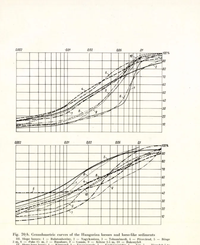
M any d ata w ere collected, especially in th e co u rse of th e d e ta ile d geological (Süm eghy, M iháltz, K á d á r, B ulla, K riván, M ihályi, L ányi). I n the course of our studies w e h a v e p u b lish ed more a n d m ore d a ta ascertaining th a t H un g arian loesses are n o t of eolian origin. A n ever-increasing n u m b er of loess v arieties could b e p ro v e d to be p ro d u c ts of fluvial (M iháltz 1950, 1953, Marosi 1955, Szilárd 1955, K á d á r 19546, 1960a) or of eluvial and d eluvial processes (Pécsi 1961c, 1961e). I n th e course of heated d e b a te s, even w ith in our Section, as to th e origin of c e rta in loess varieties, it b ec am e clear t h a t loess of eolian origin occurs, in its original em placem ent, only in sm aller areas. A tten tio n has b een called to s a n d layers, fre q u e n tly in te rc a la te d in th e loesses, by the in vestigators of th e M ezőföld (Á dám , Marosi, S zilárd) who consider them to b e chiefly of flu v iatile origin.
W e have o b serv ed during t h e last two y e a rs th a t hillside loesses, loess
lik e sedim ents, s a n d y loesses an d sands show ing a fine stra tific a tio n parallel to th e slope cover la rg e areas. I t has been asc e rta in e d th a t th e redeposition of these form ations is due p a r tly to p lu v io n iv atio n al and p a r tly to solifluc- tio n a l m ovem ent proceeding along th e slope, fo r th e m ost p a r t, still under th e influence of p erig lacial processes (Pécsi l961e, 1962a, f). W e could separate, in th is w ay, hillside loesses of d iffe re n t com position spread on a regional scale in H u n g a ry (Figs 9, 10, 11). In re c e n t years th e d etailed ex a m in a tio n of loesses h as likewise p e rm itte d us to u n d e rta k e the reg io n al m apping of fluvial loess silts lying a t th e flood plain level or a few m etre s higher an d occupying v a s t territories in L Iungary. T h e loess-like rocks of fluvial origin could be sub
div id ed into H olocene an d P leistocene loessy silts (Marosi 1955, Pécsi 1961d, e).
W e attached th e ty p e of th e san d y loess m a n tle covering th e sand dunes of o u r blow n-sand a reas in a thickness of 1— 2 m to th e c a te g o ry of the d ry superficial loesses; how ever, a fte r studying th e exposures th e y w ere correlated w ith the process of soil fo rm a tio n (K ádár 19606, Pécsi 1961c), in accordance w ith Berg’s th e o ry . O n th e basis of th e results of th e investigations carried o u t so far, we w ere th e first to m ak e an a tte m p t to represent th e H ungarian loesses and loess-like fo rm a tio n s of different h a b itu s and genesis in the form of a m ap (Fig. 12).
T he m icrofeatures of th e H u n g a rian loess reliefs, th e ir d istrib u tio n and genesis have b een d e a lt w ith b y Á dám , Marosi, a n d Szilárd (1959), when inves
tig a tin g the loesses of th e M ezőföld and th e T ra n sd a n u b ia n H ill C ountry.
Á d á m (1954), a n a ly se d in d etail th e loess valleys of th e M ezőföld, th e genesis of w hich he ascribed, first of all, to th e k a rs tin g of loess, a lth o u g h he took slu m p and slope w ash also in to account. Szilárd drew a tte n tio n to th e dialectic relationships b etw e en th e areal erosion and d erasio n processes an d the pro
cesses of linear erosion. H e has proved th a t th e tra n sfo rm a tio n of flat initial v a lle y sections in to n a rro w e r an d deeper ones is d u e to the q u a n tita tiv e changes of th e erosive a c tio n u n d e r th e influence of an in cre ase in th e a m o u n t of w a te r a n d in the slope angle, tu rn in g , beyond a c e rta in lim it, in to q u a lita tiv e changes. Marosi stu d ie d th e erosional rav in es and gullies of th e loess surfaces, the laws of th e ir d ev elo p m en t and th e d e stru c tio n of soils and grounds caused by H olocene show er w a te rs. The experience of these au th o rs proves t h a t such forms h a v e m o stly developed during th e H olocene period. The loess- m orphological stu d ie s of th e m em bers of th e S ectio n have y ield ed num erous 2 4
J'ig . 12. Spread of loesses and loess-like sedim ents in H u n g ary , according to Pécsi
t-y .-l h a l f - b o u n d , b lo w n * san d d u n e a r e a s
(PT-Tl
ri'-tn CZI
V t y p e s o f b lo w n - s a n d a re a s H o lo c e n e r iv e r b a n k d u n e s
s a n d d u n e s c o v e re d w ith t h i n s a n d y lo e ss m a n t l e o r c h e rn o z e m a l lu v iu m s o f flo o d p la in s a n d b r o o k v a lle y s
o ld e r r o c k s o f c e n tr a l m o u n t a in s th e s lo p e s o f w h ic h a re c o v e re d b y s lo p e lo ess a n d s lo p e d e b ris
g r a v e l s h e e ts a n d w id e - s p r e a d g r a v e l ly a llu v ia l fa n s
[-"''*--1 p e a t a n d p e a t m u d
I b a s a l t- c a p p e d o u tlie r s o r b a s a l t I c o v e rs
K E Y
I Loesses d e r iv in g fro m e o lia n m e n ts
m P le is to c e n e flo o d p la in lo e s s y s ilts i= q j H o lo c e n e flo o d p la in lo e s s y s ilts rpwA o b li q u e ly la m in a te d lo e ss , s a n d y
lo e ss a n d lo ess w ith r o c k d e b r is tyw A in g e n e ra l, b e d d e d c l a y e y s a n d
g la c ia l lo a m
g la c ia l lo e ss lo a m , lo e s s - lik e s lo p e d e b r is (e.g ., v a lle y loess)
ressM r e d e p o s i te d lo ess lo a m , lo e s s -lik e
“ “ Sa s lo p e d e b r is
F-rrrrri s h e e t s a n d c o v e r (H o lo c e n e - Lil* J P le is to c e n e )
I II lo e ss-lik e f o r m a tio n s d e r i v in g fro m f lu v i a ti le s e d im e n ts III lo e s-slik e r o c k s r e d e p o s ite d f r o m
s e d im e n ts o f d if f e re n t o rig in (e o li
an , f lu v ia tile , d e lu v ia l) b y p ro c e s s e s o f s o lif lu c tio n a n d p lu v i o n iv a t io n
}
IV W e s t- T r a n s d a n u b ia n lo e ss lo a m , b ro w n e a r t h , r e d e p o s ite d o n slo p es b y s o liflu c tio n■ ■, - t h i c k lo e ss p la tf o r m s m a d e u p 811 111 o f t y p i c a l loesses
Ij.i.M-m n o n - ty p i c a l , v e r y s a n d y lo e sses H a lo e s s y s a n d
I H B b s a n d y lo ess I c c o m p a c t loess
Fi g. 13. W ide, erosion-derasion valley on loess p la tfo rm . Mezőföld (P h o to E. Vajda)
Fi g. 14. Loess v a lle y intersected b y Z-shaped b re a k s. Loess p latfo rm of th e Mezőföld
d a ta for the classification of the H u n g a rian loess v arieties, for th e in te rp re ta tio n of th eir genesis and th e ch a rac te rizatio n of th e ir form w ealth (Figs 13, 14).