Global and Planetary Change 199 (2021) 103446
Available online 10 February 2021
0921-8181/© 2021 The Authors. Published by Elsevier B.V. This is an open access article under the CC BY-NC-ND license
(http://creativecommons.org/licenses/by-nc-nd/4.0/).
Research article
Multi-method comparison of modern river sediments in the Pannonian Basin System – A key step towards understanding the provenance of sedimentary basin-fill
R ´ obert Arat ´ o
a,*, Gabriella Obb ´ agy
a, Istv an Dunkl ´
b, S ´ andor J ´ ozsa
c, Keno Lünsdorf
b, J ´ anos Szepesi
a,d, Kata Moln ´ ar
a, Zsolt Benk ´ o
a, Hilmar von Eynatten
baIsotope Climatology and Environmental Research Centre, Institute for Nuclear Research, Hungarian Academy of Sciences, Debrecen, Hungary
bDepartment of Sedimentology and Environmental Geology, University of G¨ottingen, Germany
cDepartment of Petrology and Geochemistry, E¨otv¨os Lorand University, Budapest, Hungary ´
dMTA-ELTE Volcanology Research Group, Budapest, Hungary
A R T I C L E I N F O Keywords:
Provenance Thermochronology Apatite fission-track analysis Zircon fission-track analysis Heavy mineral analysis Fine-gravel petrography Pannonian Basin Alps
Carpathians
A B S T R A C T
We compared the sedimentary provenance signature of modern river sediments collected from 14 different rivers entering the Pannonian Basin. The Pannonian Basin is one of the largest sedimentary basins of Europe filled up by multiple potential sediment sources. However, the contribution of individual source areas is unknown and complex basin-fill mixtures can only be disentangled by the knowledge of more simple mixtures such as modern river sediments. Our goal was to obtain a multi-parameter dataset about modern river sediments and potential source areas as well as to identify effects that can modify primary signatures, such as recycling. We simulta- neously applied zircon and apatite fission-track detrital thermochronology (ZFT and AFT, respectively), heavy mineral analysis (HMA) via automated Raman spectroscopy and fine gravel petrography (FGP). ZFT ages cover a broader age range and show more significant dissimilarities between different rivers, than the AFT ages that mostly record the latest, Neogene cooling event of the source areas. On the other hand, heavy mineral spectra can be roughly subdivided into metamorphic, igneous and recycled signatures. Based on the amount of ultrastable minerals and the areal extent of different sedimentary reservoirs in each catchment, we can also estimate their relative contribution to recycling. Furthermore, simultaneous application of heavy mineral analysis and ther- mochronology with proper statistical treatment enables to distinguish specific source areas and mixed sedi- mentary signatures. The results provide a methodological basis for future reconstructions of tectonic and climate- based changes in the source area from mixed basin-fill sediments on a million-year scale.
1. Introduction
Sedimentary basins act as a sink for the material eroded from adja- cent mountains and thus their sedimentary fill provides the missing piece of information to understand the evolution of the sediment routing system (e.g. Carter, 2007; Malus`a and Balestrieri, 2012).
The Alpine-Carpathian realm is a set of geodynamically inter- connected sediment sources and sinks with a continuously changing post-collisional evolution history in space and time from the Oligocene until recent (e.g. Kuhlemann et al., 2002; Schmid et al., 2008; Matenco and Andriessen, 2013). During the late Miocene and Pliocene, the vast majority of the eroded material from the Eastern Alps, the Bohemian
Massif and the Carpathians was delivered to the Pannonian Basin (Kuhlemann et al., 2002). This resulted in the accumulation of thick (>6 km) basin-fill (e.g. Horv´ath et al., 2015), making the Pannonian Basin one of the largest sedimentary basins of the continent. The basin- fill can be interpreted as a complex mixture of several paleorivers’
sediments, which originate at least from six major source areas, namely the Eastern Alps, the Bohemian Massif, the Western Carpathians, the Eastern Carpathians, the Southern Carpathians and the Apuseni Moun- tains (Fig. 1a). Despite prior efforts to unravel the provenance of sedi- ment mixtures within the basin via heavy mineral analysis (HMA;
Juh´asz and Thamo-Bozs´ ´o, 2006; Tham´o-Bozs´o et al., 2006), it remains unclear to what extent each potential source area contributed to them.
* Corresponding author.
E-mail address: arato.robert@atomki.mta.hu (R. Arat´o).
Contents lists available at ScienceDirect
Global and Planetary Change
journal homepage: www.elsevier.com/locate/gloplacha
https://doi.org/10.1016/j.gloplacha.2021.103446
Received 16 March 2020; Received in revised form 2 February 2021; Accepted 4 February 2021
Modern river sediments represent the primary components of the Miocene-Quaternary (e.g. Magyar et al., 2013) basin-fill and assessing these mixtures is therefore essential for understanding more complex sediments. Differentiation between potential sources is challenging for multiple reasons. Various stages of sediment recycling in Cretaceous, Paleogene and Miocene siliciclastic sediments (Fig. 1b) can result in reset fission-track ages (e.g. Nakapelyukh et al., 2018) as well as in modifications of heavy mineral contents (e.g. Di Giulio et al., 2003).
Further difficulties are introduced by the nature of the study area, which raise the question if the studied sediments are distinguishable at all: (i) the entire Alpine-Carpathian realm shares a similar evolution history with largely similar fission-track (FT) ages and/or bedrock composition (Figs. 1 and 2) and (ii) modern rivers drain multiple terranes and carry a mixed detrital signal.
In order to link primary sediments to bedrock, describe the detrital
signature of potential source areas and estimate the relative contribution of different sedimentary units to recycling, in this study we compare modern river sediments with respect to their detrital zircon fission-track (ZFT) and apatite fission-track (AFT) ages as well as their heavy mineral (HM) spectra and fine gravel (FG) content. This study is also an attempt to exploit the high discriminating potential of multi-method provenance analysis combined with multi-parameter statistical treatment. More- over, with our new detrital ZFT, AFT, heavy mineral and petrographic dataset we make a crucial step towards understanding the complex basin-fill of the Pannonian Basin.
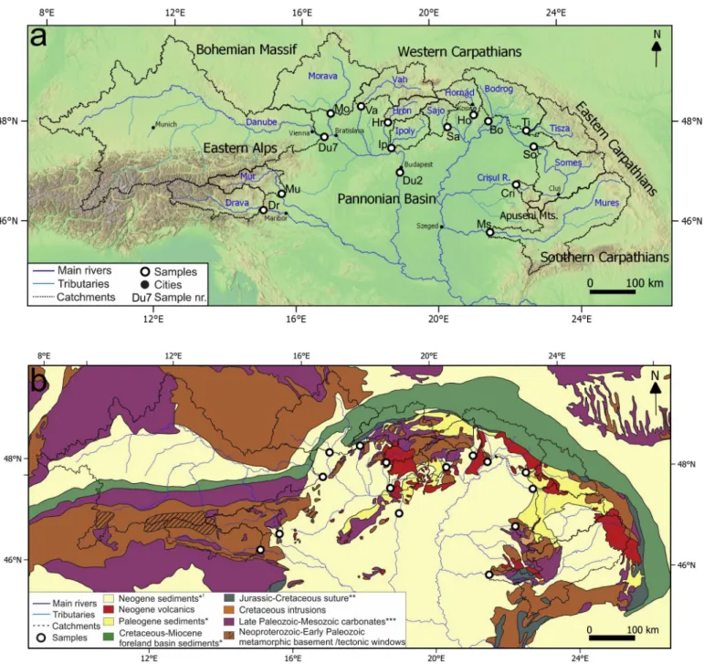
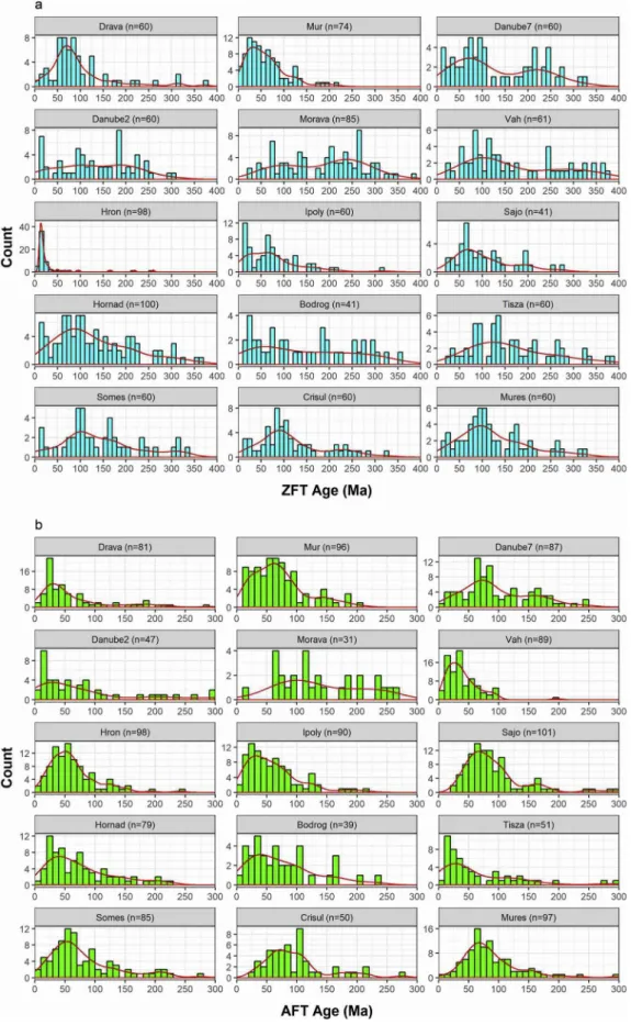
Fig. 1. (a) Topographic map of the study area and the catchments of sampled rivers with the sampling sites. (b) Geological map of the study area (simplified after Asch, 2003). *clastic sediments **carbonates in the Western and Eastern Carpathians and ophiolites (+carbonates) in the Apuseni Mts. and Southern Carpathians
***also subordinately/locally clastic sediments. 1Neogene and also Quaternary sediments.
(caption on next page)
2. Geological background
2.1. The Alpine-Carpathian-Pannonian source to sink system
The 800,000 km2 catchment area of the modern Danube river covers a significant part of the European continent, spanning from the Eastern Alpine foreland to the Black Sea. Its tributaries drain diverse geological units from several major mountain belts of the region, including the Eastern Alps, the Bohemian Massif, the Carpathians and the Apuseni Mountains (Fig. 1). The complex structure of these orogens reflects a superposition of multiple mountain-building events that can be traced back from recent times to the Paleozoic (e.g. Frisch, 1979; Stampfli et al., 1991; Csontos and V¨or¨os, 2004). Large parts of the crystalline basement in the Alps and Carpathians as well as the Bohemian Massif formed during the Late Ordovician – Late Carboniferous Variscan orogeny (e.g. Franke, 2000). Subsequent Cretaceous-Paleogene collision and nappe-stacking of the African and Eurasian continents is related to the Jurassic subduction of the Neotethys ocean (e.g. Frisch, 1979), commonly referred to as the Eoalpine event. This event partly overlaps with the Cretaceous-Eocene closure of the Alpine Tethys Ocean (e.g.
Bertotti et al., 1999), subsequent collision and exhumation (“Neoalpine event”).
The Oligocene to recent post-collisional evolution history of the Eastern Alps and Carpathians was accompanied by the gradual eastward migration of the dominant sinks of eroded sediments. The foreland basin of the Alps served as the major sink of Eastern Alpine detritus from the Oligocene (ca. 30 Ma) until the late Miocene (ca. 11–10 Ma; Kuhlemann and Kempf, 2002) when the main depocenter was shifted to the Pan- nonian Basin. Accordingly, the Pannonian Basin stores most of the ma- terial that was eroded from the Eastern Alps, the Bohemian Massif and Carpathians between the late Miocene (ca. 11–10 Ma) and late Pliocene (Kuhlemann et al., 2002). Sediments were delivered to the basin by several rivers from different directions, most probably including the precursor of the Danube (Magyar et al., 2013). It is clear from changing shelf-margin progradation directions (Magyar et al., 2013) that the source of sediments changed multiple times between 10 and 4 Ma. This is also supported by differences in the detrital (apatite and zircon) fission-track age distributions (Tari et al., 1999) and HM association of the basin-fill (Thamo-Bozs´ ´o et al., 2006).
Several modern river sediments in the study area were also investi- gated in prior studies with respect to their HM assemblage (e.g. Szab´o, 1955; Moln´ar, 1964; Gedeon-Rajetzky, 1973; Thamo-Bozs´ ´o and Kov´acs, 2007). Thamo-Bozs´ ´o and Kov´acs (2007) could distinguish the HM signature of Danube and Tisza (and most of their tributaries) via prin- cipal component analysis, identify characteristic features of the Carpa- thians and Apuseni Mountains in detrital material and also explain the origin of certain Quaternary sediments in boreholes.
2.2. Geology and characteristic lithologies of the potential source areas The information described in this section is summarized in Fig. 1b and Table S1.
2.2.1. Bohemian Massif
The Bohemian Massif represents the relatively stable central Euro- pean crust consolidated during the Variscan orogeny (e.g. Franke and Zela˙ ´zniewicz, 2002), in contrast to the much younger Alpine-Carpathian mountain chain (Figs. 1, 2). It is dominated by variably metamorphosed Neoproterozoic to Lower Paleozoic volcano-sedimentary successions and igneous complexes, Variscan (ca. 350–300 Ma; e.g. Klein et al., 2008; Janouˇsek et al., 2010) felsic to ultrapotassic igneous rocks as well as by Upper Cretaceous sediments.
2.2.2. Eastern Alps
The Eastern Alps are dominated by a multiply deformed basement and its weakly metamorphosed cover nappes of African origin (e.g.
Froitzheim and Manatschal, 1996; Fig. 1b). Their continuation also comprises the basement of the northern Pannonian Basin (Balla, 1984).
Basement units consist of predominantly (Neoproterozoic–)Paleozoic amphibolite and greenschist facies metamorphic rocks with eclogitic occurrences along the Mur River (e.g. Miller et al., 2005). Their Meso- zoic cover sequences in the north are dominated by carbonates.
Tectonic windows (Fig. 1b) expose Europe-derived continental se- quences and their cover units related to the Cretaceous-Eocene Alpine Tethys closure (e.g. Frisch, 1979). Their lithology spans a range from greenschist and amphibolite facies rocks (Fig. 2a) to widespread blues- chists and subordinate eclogite facies rocks (e.g. Bousquet et al., 2008).
The northern foreland of the Alps is represented by voluminous foreland deposits (Fig. 1b), with Early Cretaceous – early Eocene and early Oligocene – late Miocene siliciclastic sequences (e.g. Faupl and Wagreich, 1992; Kempf et al., 1999).
2.2.3. Carpathians
The Carpathian arc can be geographically subdivided into Western-, Eastern-, and Southern Carpathians (Fig. 1a). Structurally, it consists of the Inner Carpathians and a foreland basin (i.e. Outer Carpathians) with an oceanic suture (i.e. Klippen Belt) zone in-between (e.g. S˘andulescu et al., 1981; Nemˇcok et al., 1998; Krobicki et al., 2003; Fig. 1b).
The major nappes of the Inner Carpathians comprise a dominantly Neoproterozoic – Early Paleozoic basement, covered by late Paleozoic – Mesozoic sedimentary sequences (e.g. Sandulescu et al., 1981; Kov˘ ´aˇc et al., 1994; Plaˇsienka et al., 1997; Fig. 1b). Basement units are mainly amphibolite facies rocks (Fig. 2a), metamorphosed during the Caledo- nian and the Variscan orogenies (e.g. Balintoni and Balica, 2013; Stoica et al., 2016). These were intruded by granitoids at various stages during the Paleozoic (e.g. Uher and Broska, 1996; Seghedi et al., 2005; Balin- toni and Balica, 2013). Locally, basement rocks experienced a Creta- ceous greenschist facies overprint as well (Daniˇsík et al., 2008a;
Kr´alikov´a et al., 2014a). Sedimentary cover sequences of the basement nappes include clastic and carbonatic successions, which were meta- morphosed up to greenschist facies conditions in the Cretaceous (e.g.
S˘andulescu et al., 1981; Bojar et al., 1998; Petrasov´a et al., 2007). Large areas of the basement are autochtonously covered by (Cretaceous –) Paleogene and Neogene clastic sediments (e.g. Kr´ezsek and Bally, 2006;
Fig. 1b). These serve as significant sources of recycled material in the study area (e.g. Schuller and Frisch, 2006; Obb´agy et al., 2021). The bedrock pattern of the Inner Carpathians is further complicated by Fig. 2. (a) Bedrock heavy mineral content compilation *zircon, tourmaline, rutile, ** sillimanite, kyanite, staurolite, chloritoid; Zrn =zircon, Ap =apatite, Grt =garnet, Ep =epidote, Am =amphibole Cpx =clinopyroxene, Opx =orthopyroxene, Cr-Spl =chromian spinel, (b) Zircon and (c) apatite bedrock fission-track age compilation based on Grundmann and Morteani (1985), Flisch (1986), Hurford (1986), Staufenberg (1987), Hejl and Grundmann (1989), Neubauer et al.
(1995), Fügenschuh et al. (1997), Hejl (1997), Dunkl et al. (1998), Elias (1998), Sachsenhofer et al. (1998), St¨ockhert et al. (1999), Trautwein et al. (2001), Viola et al. (2001), Dunkl et al. (2009) [Alps]; Hejl et al. (1997, 2003), Glasmacher et al. (2002), Vamvaka et al. (2014), Botor et al. (2017), Sobczyk et al. (2020) [Bohemian Massif]; Burchart (1972), Kr´al (1977), Kov´aˇc et al. (1994), Daniˇsík et al. (2004, 2008a, 2008b, 2010, 2011, 2012), Plaˇsienka et al. (2007), Zattin et al.
(2011), Andreucci et al. (2013), Kr´alikov´a et al. (2014a, 2014b, 2016), Anczkiewicz et al. (2015), ´Smigielski et al. (2016), Vojtko et al. (2016) [Western Carpathians];
Sanders et al. (1999), Merten et al. (2010), Gr¨oger et al. (2013), Andreucci et al. (2015), Nakapelyukh et al. (2018) [Eastern Carpathians]; Bojar et al. (1998), Schmid et al. (1998), Moser et al. (2005), Fügenschuh and Schmid (2005), Matenco (2017) [Southern Carpathians]; Schuller (2004), Schuller et al. (2009), Merten et al.
(2011), Kounov and Schmid (2013), Reiser et al. (2017) [Apuseni Mountains]. Neogene volcanics are automatically categorized as <20 Ma. Striped areas indicate sporadic occurrences or mixed/transitional FT age populations.
widespread calc-alkaline volcanics (Fig. 1b, Table S1). They show pro- gressive NW-SE younging (between ca. 16 and 0.03 Ma) along the arc (P´ecskay et al., 1995; Lexa et al., 2010; Moln´ar et al., 2019) and are mainly concentrated in the Western Carpathians. Miocene (between ca.
18 and 14 Ma; Luk´acs et al., 2018) felsic pyroclastics are also present, mainly distributed along a SW-NE swath in the Western Carpathians.
The Outer Carpathians represent an accretionary wedge comprising a thin-skinned nappe stack of Upper Jurassic to lower Miocene clastic foreland basin sediments (Figs. 1b, 2a) thrust over the Miocene- Quaternary sediments of the European foredeep (e.g. Oszczypko, 2006).
2.2.4. Apuseni Mountains
The Apuseni Mountains represent the surface outcrops of basement nappes found beneath the Pannonian Basin (Fig. 1; e.g. Csontos and Vor¨¨os, 2004). The northern Apuseni Mountains comprise a roughly NW- verging Mesozoic stack of three continental basement and/or cover nappe systems (Dallmeyer et al., 1999; Csontos and Vor¨¨os, 2004). All three units contain a crystalline basement of Precambrian – Cambrian protolith age, which were metamorphosed at amphibolite facies condi- tions during Variscan orogeny (e.g. Balintoni et al., 2010) and experi- enced greenschist facies overprint during the Eoalpine phase (e.g. Reiser et al., 2019). The basement nappes had been intruded by syn- to post- Variscan granitoids and transgressively covered by Permian to Lower Cretaceous carbonates and siliciclastic sediments (Pan˘a et al., 2002;
Balintoni et al., 2010). Further igneous occurrences in the Apuseni Mountains include Late Cretaceous intrusions (e.g. Gallhofer et al., 2015) and Neogene volcanics (Fig. 1b, Table S1). The three nappe sys- tems are unconformably covered by late Albian to Cenomanian clastic sediments and by Turonian to Maastrichtian “Gosau-type” sediments (e.
g. Schuller et al., 2009). The previously described units are separated from the Southern Carpathians by Neotethys-related ophiolitic nappes, occupying the largest part of the southern Apuseni Mountains (Nicolae, 1992).
2.3. Available bedrock FT ages of the potential source areas
Bedrock FT data is summarized in Fig. 2b and c as well as in Table S1.
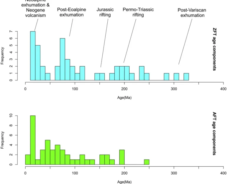
The most widespread ZFT ages (Fig. 2b) in the study area are Eoalpine (120–60 Ma), intersected by areas of <20 Ma ZFT ages at tectonic win- dows in the Eastern Alps (cooling ages/mixed ages) and at Miocene – Quaternary volcanic occurrences (eruption ages) along the Carpathians and Apuseni Mountains. The Bohemian Massif stands out with old, dominantly pre-Mesozoic (>250 Ma) ZFT ages, whereas scattered oc- currences of ZFT ages between 250 and 120 Ma are found throughout the study area. Available bedrock AFT ages show a more complete areal coverage than ZFT ages but they cover a much smaller age range (Fig. 2c). Areas with young (<20 Ma) AFT ages are the most widespread, recording exhumation (Alps, Carpathians) and volcanic activity (Car- pathians, Apuseni Mts.) as well. Older AFT ages are found throughout the study area, but they are dominant in the Bohemian Massif, the Inner Western Carpathians, the Apuseni Mts. and the foreland basin (Fig. 2c).
Detailed descriptions of potential source areas with respect to FT ages can be found in Electronic Appendix 1.
3. Samples, methods and data evaluation
Modern river sand samples (Table 1) were collected from the main rivers entering the Pannonian Basin, preferentially from locations close to the entry point (Fig. 1). Where unbiased sampling was hindered by hydroelectric dams, material was collected from Quaternary gravel and sand bars. Usually one sample per river was studied. In order to check if the collected samples are representative, a control sample was also taken from the Tisza and Vah rivers and analyzed by means of HMA (Table S2).
The Danube2 sample was collected from a Quaternary gravel bar far from the basin entry point (for mimicking mixed basin-fill sediments) in order to check if it returns an intermediate sedimentary signature
between individual rivers’ samples.
Approximately 5–7 kg of clastic material was collected from each sampling site. According to laser particle sizer measurements, the sam- ple material was dominated by medium (250–500 μm) to coarse (500–1000 μm) sand, underlining the comparability of individual sam- ples. In order to minimize sampling bias, we sampled (and mixed) several sand bars at each site, usually covering ca. 100 m of horizontal and 10 m of vertical distance.
Most rivers cross state borders and have different names in local languages. In order to avoid confusion, in this study we give preference to the nomenclature applied along the longest course of each river. The Danube represents an exception in this respect due to its well- established name in English.
3.1. Zircon and apatite fission-track analysis
Samples for ZFT and AFT analysis were prepared from the 63–125 μm fraction and further concentrated by a Frantz magnetic separator. Samples were bulk-embedded, meaning that no further treatment or handpicking was applied in order to avoid fractionation or operator bias. In addition to track counting, the shape of crystals (euhedral/anhedral) was registered systematically. This information was used as an additional constraint in catchments that covered both Miocene volcanic fields and areas with Miocene cooling ages. For zircon and apatite fission-track analysis the external detector method was applied (Gleadow, 1981). Fission tracks were counted (Table 2) by R.A.
in the newly established fission-track laboratory at the Institute for Nuclear Research of Hungary by an Olympus BX53 microscope equipped with a microscope-computer-controlled stage system (Dumitru, 1993).
Personal zeta values were 289.8 ±4.9 and 116.7 ±2.2 for apatite and zircon, respectively.
3.2. Heavy mineral analysis
For Raman analysis of heavy minerals (see e.g. And`o and Garzanti, 2014; Lünsdorf et al., 2019), heavy mineral concentrates (63–125 μm fraction) were embedded into epoxy resin and cylindrical mounts of 25 mm diameter were prepared. The mounts were ground and polished in the same manner as the FT samples. Raman spectroscopy measure- ments were performed at the University of G¨ottingen by a Horiba Jobin Yvon XploRA Plus spectrometer equipped with an Olympus BX41 mi- croscope, a 532 nm diode laser and a motorised x-y-z stage.
3.3. Fine gravel petrography (FGP)
Where available, the 1.5–2.5 mm fraction obtained by custom made sieves was processed for petrography. For simplicity, the method is Table 1
Sample localities.
Sample Nr. Locality Sample description
Latitude Longitude
Drava 46.607489 14.982370 Terasse, gravel pit
Mur 46.946569 15.506110 Gravel pit
Danube7 48.111668 16.746363 Sand/gravel bar
Danube2 47.386620 19.009990 Gravel bar
Morava 48.601380 16.934099 Gravel bar
Vah 48.744820 17.857410 Gravel pit
Hron 48.407127 18.645440 Sand/gravel bar
Ipoly 47.889053 18.761845 Riverbed material
Sajo ´ 48.283320 20.443129 Sand/gravel bar
Horn´ad 48.500538 21.259626 Gravel pit
Bodrog 48.361744 21.688684 Sand bar
Tisza 48.118020 22.821182 Sand/gravel bar
Somes¸ 47.778553 23.009953 Sand/gravel bar
Mures¸ 46.108303 21.569970 Sand/gravel bar
Cris¸ul Repede 47.044456 22.408997 Gravel pit
referred to as ‘fine gravel petrography’, although the studied fraction also contained very coarse sand. The applied grain size range is large enough for the identification of rock types, whereas it allows for the description of a statistically robust amount of grains. This approach helps linking different heavy minerals within a sample to certain source rock types. Due to their resistivity, quartzite and gneiss are dominant in almost all samples (Table S2) while carrying little information about provenance. Therefore, quartzite was not included in FGP plot and FGP data were not evaluated quantitatively.
3.4. Statistical dissimilarity measures
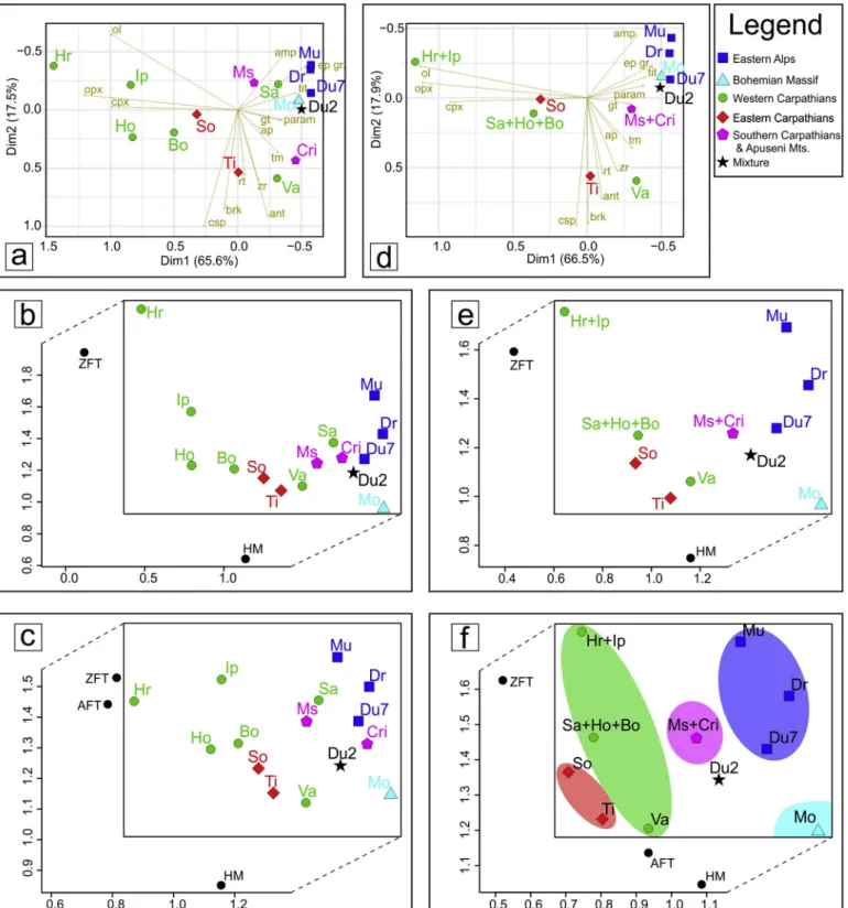
The data obtained via the methods described above were treated by the ‘provenance’ package of Vermeesch et al. (2016) and by the ‘fac- toextra’ package (Kassambara, 2017), both running in R. More specif- ically, special cases of multidimensional scaling, namely correspondence analysis and the so-called individual scaling was applied to our dataset.
The choice of methods is largely based on the recommendations made by Vermeesch (2019). Multidimensional scaling is a superset of principal component analysis that can be used for extracting two- (or higher) dimensional information from a higher dimensional dataset, using pairwise distances between objects (e.g. Torgerson, 1952; Vermeesch, 2013). Our dataset includes different kinds of data, such as point- counting (HM) and age data (ZFT and AFT). Dissimilarity measures in the case of the current dataset were based on the Kolmogorov-Smirnov test (K–S test) and Chi-square test for age data and point counting data, respectively. Correspondence analysis was applied to our HM dataset, as it is similar to but better suited for comparing point-counting data including zero values than the more traditional principal component analysis (Vermeesch, 2019). On the other hand, individual scaling is ideal for comparing different types of data – such as our dataset – via different dissimilarity measures and summarizing dissimilarities in one plot.
Further methodological details can be found in Electronic Appendix 2.
4. Results
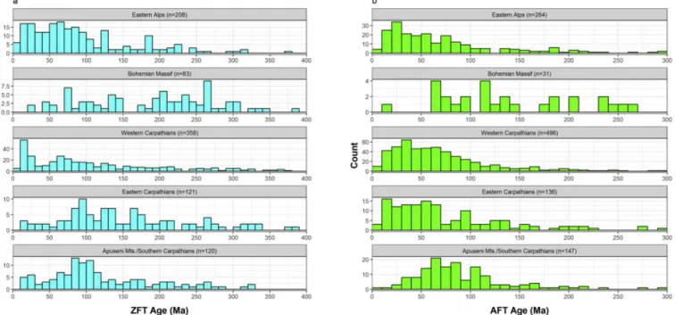
The following results are summarized in Tables 2–4 as well as in Figs. 3 and 4.
4.1. Bohemian Massif
The detrital ZFT spectrum of the Morava river (Fig. 3a) is dominated by ages around 200 Ma and older. The dominance of the Permo-Triassic ZFT age component (>60%, Table 4) is unique to this river. This is accompanied by a Triassic AFT age component of ~50%. However, the Morava sample contains a low amount of datable apatite grains and AFT ages are more or less evenly scattered between 270 and 60 Ma. The HM assemblage of the Morava river contains mostly metamorphic minerals, such as garnet, parametamorphic minerals (sillimanite, kyanite, stau- rolite, chloritoid), epidote group minerals (epidote, zoisite, clinozoisite), as well as about 16% ZTR (zircon+turmaline+rutile) and <1% chro- mian spinel.
4.2. Eastern Alps
Major rivers draining the Eastern Alps and entering the Pannonian Basin are Drava, Mur and Danube (only part of its catchment). The detrital FT spectrum (Figs. 3a, b) of the Drava river is dominated by 100–50 Ma ZFT (~70%) and 50–20 Ma AFT ages (~80%), respectively (Table 4). Its HM association is characterized by garnet (>30%), epidote group minerals (ca. 20%) and amphibole (ca. 20%), similarly to the HM assemblage of the Mur (Fig. 4a; Table 3). On the other hand, the Mur sample contains abundant (~60%) ZFT ages younger and AFT ages older than 50 Ma (Fig. 3). The proportion of ZTR minerals is around 10% in Table 2 Results of zircon and apatite fission-track dating. Bold numbers indicate central ages and corresponding 1 σ standard deviation.
Sample Nr.
Zircon Apatite
Counted crystals Spontaneous Induced Pχ2(%) Disp. ρd nd
Central age
±1σ
Counted crystals Spontaneous Induced Pχ2(%) Disp. ρd nd
Central age
±1σ ρs ns ρi ni ρs ns ρi ni Drava 60 80.909 3237 118.626 4746 0 0.58 17.75 15,832 81.3 ± 6.6 81 4.435 910 12.66 2598 0 0.72 6.61 6016 49.7 ± 4.8 Mur 74 65.749 2851 94.945 4117 0 0.48 18.95 15,832 79.8 ± 5.1 96 9.194 1812 15.627 3080 0 0.49 6.3 6016 56.8 ± 3.7 Danube7 60 125.37 3919 154.098 4817 100 0.75 18.52 15,832 106 ± 10.8 87 20.225 3338 24.478 4040 0 0.57 6.8 6016 83.8 ± 6 Danube2 60 114.163 3838 135.61 4559 – 0.78 16.43 15,832 151.9 ± 15.7 47 5.427 773 13.353 1902 0 0.86 7.23 6016 56.3 ± 7.7 Morava 85 111.692 5979 75.751 4055 0 0.58 17.58 15,832 198.7 ± 12.2 31 23.322 1028 19.919 878 0 0.54 6.86 6016 125.9 ± 14.4 Vah 61 119.743 4826 104.384 4207 0 0.62 18.73 15,832 140.5 ± 12 89 7.011 1539 19.725 4330 0 0.55 6.55 6016 35.3 ± 2.5 Hron 60 39.303 2014 198.175 10,155 0 0.91 17.31 15,832 22.7 ± 2.8 98 10.372 2223 19.886 4262 0 0.51 6.92 6016 56.6 ± 3.7 Ipoly 60 78.04 3268 161.549 6765 0 0.72 16.76 15,832 59.6 ± 5.8 90 7.194 1739 13.262 3206 0 0.56 6.457 6016 49.5 ± 3.6 Saj´o 41 82.16 1823 110.192 2445 0 0.57 19.5 15,832 92.5 ± 8.9 101 16.07 2990 20.267 3771 0 0.34 6.49 6016 77.7 ± 3.8 Horn´ad 100 100.112 5379 121.087 6506 – 0.69 19.66 15,832 112.3 ± 8.3 79 10.388 1939 17.615 3288 0 0.63 6.74 6016 62.6 ± 5.1 Bodrog 41 113.681 2217 141.575 2761 0 0.83 18.14 15,832 110.6 ± 14.8 39 11 771 20.382 1429 0 0.63 6.98 6016 58.7 ± 6.8 Tisza 60 106.575 4421 85.084 3530 0 0.58 18.3 15,832 141.6 ± 11.6 52 6.94 499 18.88 1358 0 0.77 6.92 6016 46.4 ± 5.8 Somes¸ 61 112.066 4109 118.475 4344 0 0.67 19.28 15,832 122.8 ± 11.1 85 9.111 1708 13.566 2543 0 0.57 6.37 6016 63.8 ± 4.8 Cris¸ul Repede
60 98.302 4474 135.116 6150 0 0.61 20.05 15,832 101 ± 8.5 50 8.976 1211 11.051 1491 0 0.39 6.43 6016 82.6 ± 6.2 Mures¸ 60 124.11 3599 130.921 3797 0 0.6 16.98 15,832 102.8 ± 8.6 97 8.385 1796 10.152 2175 0 0.35 6.395 6016 75.8 ± 4.2 ρs, ρ,i =spontaneous and induced track density, n =number of tracks, Pχ2 =chi-squared value, Disp. =dispersion.
the Danube river (Danube7) sample, roughly the double of of their abundance in Drava and Mur (Table 3). Besides abundant AFT (~50%) and ZFT ages (~45%) between 100 and 50 Ma, the Danube7 sample is also characterized by a Jurassic AFT and a Permo-Triassic ZFT age component (Table 4).
4.3. Western Carpathians
The ZFT spectrum of the Vah sample shows a broad scatter of ages between Paleozoic and Paleogene (Fig. 3a) and a restricted set of AFT ages between 100 and 5 Ma (Fig. 3b). These ages are accompanied by a low amount of amphibole (ca. 4%; Table 3) but abundant ZTR (28%) and chromian spinel (>2%). Among the fine gravels (Fig. 4b) granitic and sedimentary/metasedimentary constituents dominate.
ZFT ages in the Hron river sample contain ages almost exclusively (~90%) between 20 and 10 Ma (Fig. 3a) whereas its AFT age distribu- tion (Fig. 3b) is dominated by Late Cretaceous-Paleogene ages. Heavy mineral and fine gravel data suggest extreme dominance of volcanic constituents (e.g. ~80% pyroxene, Fig. 4a).
The Ipoly river sample also comprises abundant ZFT ages between 20 and 10 Ma (~30%), but it is dominated by ages between 100 and 50 Ma (~50%; Fig. 3a). Among AFT ages the Paleogene (45%, Table 4) and the Late Cretaceous (28%) age components are the most dominant. Both the ZFT and the AFT spectrum includes scattered, but noticeable ages be- tween 250 and 100 Ma as well. Its HM and FG composition is similar to the Hron sample, however, the dominantly volcanic signal (>50% py- roxene) is diluted by over 20% garnet and other metamorphic constit- uents (Fig. 4).
ZFT and AFT ages of the Saj´o river can be grouped into Paleogene (~10%), Late-Cretaceous (~55%) and Jurassic (~35%) age components (Table 4). The HM association is dominated by mainly metamorphic constituents, such as garnet (>30%) and epidote group minerals (>20%), whereas the most abundant lithologies among fine gravels are phyllite, micaschist, granite and metasandstone (Fig. 4b).
The Horn´ad sample shows widespread ZFT ages with Miocene (~10%), Late Cretaceous–Paleogene (~20%) and Early Cretaceous (~30%) ZFT and AFT (30%, 40%, 30%, respectively) components as well as a Jurassic ZFT component (~30%; Table 4.). Among HM-s py- roxenes are the most abundant (>50%), but garnet and ZTR are also present in more than 15% (Table 3). Fine gravels are evenly distributed between the magmatic, sedimentary and metamorphic group. The metamorphic group is represented by abundant mylonitic gravels, a unique feature in this sample (Fig. 4b).
The Bodrog river sample contains few datable zircon and apatite grains. ZFT ages are evenly scattered with no clearly detectable age components, whereas AFT ages are <110 Ma (>80%) with an apparent maximum between 40 and 30 Ma (Fig. 3). Importantly, all ZFT and AFT ages between 20 and 10 Ma were obtained from euhedral grains. The HM spectrum of this sample is a balanced mixture of volcanic (e.g. py- roxenes: 40%), ultrastable (ZTR: 12%) and metamorphic (e.g. garnet:
29%) minerals.
In summary, the Western Carpathians shed a broad range of ZFT ages to the Pannonian Basin with abundant Miocene, Cretaceous (Eoalpine and pre-Eoalpine) and Variscan to Jurassic ages (Fig. 5a). These are accompanied by dominantly Paleogene and Cretaceous AFT dates (Fig. 5b). Heavy mineral and fine gravel compositions carry evidence for input from volcanic, metamorphic and recycled sedimentary sources, the volcanic component being dominant except for the Vah and the small Sajo catchment. ´
4.4. Eastern Carpathians
The Eastern Carpathians include the entire Tisza and the largest part of the Somes¸ catchment (Fig. 1). ZFT ages in the Tisza sample (Fig. 3a) are evenly spread with no clearly definable age components (Fig. 3a). On the other hand, AFT ages are concentrated between 70 and 10 Ma with a Table 3 Results of heavy mineral analysis via Raman-spectroscopy. in % Rt Ant Brk Zrn Tur Ap Mnz Cr-Spl Grt Param Ttn Ep gr. Act-Tr Ed Hbl Cpx Opx Ol Other ZTR n Drava 2.6 0.0 0.1 0.1 2.2 9.3 0.0 0.0 35.8 1.9 3.4 22.5 7.4 8.7 4.5 1.0 0.0 0.0 0.4 4.9 732 Mur 3.2 0.0 0.1 0.4 1.4 3.4 0.0 0.0 39.6 4.2 2.2 16.9 6.3 14.0 7.3 0.3 0.1 0.0 0.4 5.0 714 Danube7 7.3 0.3 0.1 1.6 0.8 3.7 0.0 0.0 40.5 4.6 3.1 25.5 5.2 4.6 2.4 0.3 0.0 0.0 0.1 9.7 765 Danube2 4.5 0.0 0.2 1.4 0.9 1.4 0.3 0.3 55.9 6.1 1.6 13.3 3.0 4.7 3.1 0.9 1.4 0.2 0.7 6.8 572 Morava 8.1 0.2 0.7 6.6 1.6 2.6 0.2 0.2 27.3 6.0 2.0 9.2 12.3 14.7 7.1 0.5 0.2 0.0 0.5 16.3 546 Vah 18.3 0.6 1.7 6.4 3.1 8.3 1.4 2.5 39.2 1.6 1.1 6.8 1.2 2.0 1.2 2.2 1.8 0.1 0.5 27.8 649 Hron 1.6 0.2 0.0 0.6 0.0 2.2 0.5 0.0 1.3 0.0 0.3 3.4 0.5 1.0 6.1 18.4 61.6 2.1 0.3 2.2 625 Ipoly 2.4 0.2 0.3 0.8 0.3 1.6 0.2 0.0 22.3 1.5 0.5 2.9 0.8 1.3 7.8 14.8 42.0 0.2 0.2 3.6 615 Saj´o 6.3 0.9 0.2 1.3 1.7 5.4 0.0 0.2 32.2 1.1 2.8 24.6 4.4 4.6 2.7 1.7 7.6 1.4 0.8 9.3 633 Horn´ad 11.7 0.3 1.0 2.5 1.3 4.9 0.0 2.1 14.2 2.2 0.6 1.5 1.2 0.9 1.5 10.7 42.1 0.4 0.9 15.6 675 Bodrog 9.5 0.5 0.9 2.0 0.9 3.1 0.1 1.0 29.2 2.9 0.9 2.8 1.0 1.7 1.9 9.8 30.9 0.1 0.6 12.4 783 Tisza 16.4 2.1 2.0 4.4 1.9 7.6 0.3 0.5 34.9 1.6 0.9 6.1 0.8 1.2 0.7 8.0 10.0 0.0 0.4 22.7 748 Somes¸ 8.0 0.0 0.3 1.9 1.7 2.4 0.0 1.2 28.4 4.2 1.7 3.4 2.9 4.1 5.3 8.8 25.0 0.3 0.5 11.5 589 Cris¸ul 9.9 3.1 0.2 4.9 2.6 3.1 1.2 0.5 46.9 8.4 3.9 8.1 2.0 1.8 2.5 0.2 0.3 0.0 0.5 17.4 608 Mures¸ 7.0 0.3 0.2 1.8 1.2 3.2 0.0 0.0 24.8 4.2 2.8 18.0 5.3 5.7 7.2 6.2 11.8 0.3 0.0 10.0 600 Rt =rutile, Ant =anatase, Brk =brookite, Zrn =zircon, Tur =tourmaline, Ap =apatite, Mnz =monazite, Cr-Spl =chromian spinel, Grt =garnet, Param =sillimanite, kyanite, staurolite, chloritoid, Ttn =titanite, Ep gr. =epidote group, clinozoisite, zoisite, Act-Tr =actinolite-tremolite, Ed =edenite, Hbl =other amphibole, mainly hornblende, Cpx =clinopyroxene, Opx =orthopyroxene, Ol =olivine.
20–10 Ma maximum and show a strong negative skewness (Fig. 3b). In order to unravel the source of Miocene ages (magmatic or cooling ages), shapes of young (<25 Ma) apatite grains were thoroughly investigated under microscope. Accordingly, the sample contains only rounded young apatite crystals, euhedral apatite grains being completely absent.
Furthermore, this sample shows a high ZTR content (23%), whereas pyroxene (~20%) and chromian spinel (0.5%) are also present (Fig. 4a).
The fine gravel spectrum shows sandstone dominance and felsic volcanic contribution (Fig. 4b).
Dominant age components in the Somes¸ sample are around 100 Ma for ZFT (~50%) and 50 Ma for AFT ages (~65%), respectively (Fig. 3, Table 4). Further ZFT and AFT age components include Jurassic and Miocene ones. Heavy mineral and fine gravel compositions show a mixed composition (Fig. 4). Heavy minerals are dominated by over 30%
pyroxene, somewhat less garnet and around 10% ZTR.
In summary, the “Eastern Carpathian” signal can be distinguished from the signatures of the other four source areas by the following characteristics: (i) volcanic heavy minerals form a significant compo- nent but are less dominant compared to the Western Carpathians, (ii) high ZTR and sedimentary gravel content (especially in the Tisza catchment) (iii) abundant young (<20 Ma) rounded apatite crystals (iv) early Late Cretaceous ZFT age maximum at around 100–90 Ma (Fig. 5).
4.5. Southern Carpathians/Apuseni Mts
Although the catchment of the Cris¸ul Repede is restricted to the Apuseni Mts., whereas the Mures¸ also samples the Eastern and Southern Carpathians, the two rivers are included in one group here for simplicity.
The catchment of the Cris¸ul Repede represents only a small part of the study area (Fig. 1b). Its ZFT and AFT spectra show a maximum around 100 Ma and abundant ages between 100 and 50 Ma (ZFT: ~60%; AFT:
85%; Fig. 3). A further, Jurassic component appears in both spectra (Table 4). The HM composition is dominated by over 40% garnet, but
the ZTR content (17%) is also significant (Fig. 4a, Table 3). This sample shows the second highest felsic/intermediate igneous gravel content after the Hron (Fig. 4b).
The Mures¸ drains a wide range of geological formations from the Apuseni Mts., the Eastern Carpathians and the Southern Carpathians.
ZFT data can be described by a Miocene (12%), a Late Cretaceous (55%) and a Late Triassic/Early Jurassic age component (33%, Table 4). It is remarkable that the ophiolitic occurrences in the Mures¸ catchment are clearly detectable by FGP (Fig. 4b), but chromian spinel is completely absent from the heavy mineral spectrum (Fig. 4a).
In summary, the provenance signature of the Southern Carpathians/
Apuseni Mts. is dominated by ZFT and AFT ages between 120 and 50 Ma (Fig. 5) and a heavy mineral spectrum with low volcanic contribution (as compared to Eastern and Western Carpathians).
5. Discussion 5.1. Role of recycling
In order to evaluate the agreement between detrital signatures and available bedrock data, the effect of possible recycling has to be considered. In the study area, Cretaceous – Miocene foreland basin sediments, Paleogene sediments and Neogene sediments can act as sources for recycled material. We calculated the areal distribution of the three sedimentary basin types in each catchment (Table 5). Combined with our provenance dataset this allows for estimating their relative contribution to recycling. Notably, we did not quantify various factors (e.g. fertility, diagenesis, topography) in this study that could potentially also influence our results (e.g. Morton and Hallsworth, 1999; Caracciolo, 2020).
The ZTR index (Huber, 1962) is the most common indicator of recycling, however, it can be significantly biased by igneous and metamorphic bedrock characterized by high fertility with respect to Table 4
Results of zircon and apatite fission-track age component identification using Binomfit software (Brandon, 2002).
M1 SD1 SD1 Frac. M2 SD2 SD2 Frac. M3 SD3 SD3 Frac. M4 SD4 SD4 Frac.
ZFT age components
Drava 16.8 −2.4 2.8 9.7 70.9 − 5.2 5.7 67.6 191.7 − 25.9 29.8 22.6
Mur 33.0 −6.5 8.2 14.9 75.8 − 7.1 7.8 67.8 186.8 − 30.1 35.7 17.3
Danube7 19.9 −2.4 2.7 14.6 78.3 − 5.9 6.4 44.0 235.4 − 19.7 21.4 41.4
Danube2 16.1 −1.8 2.0 15.2 85.8 − 8.5 9.5 32.9 203.2 − 17.2 18.7 51.8
Morava 36.3 −5.3 6.2 7.4 96.0 − 9.4 10.4 28.2 240.0 − 17.3 18.6 64.4
Vah 41.3 −5.3 6.1 12.0 110.1 − 8.1 8.8 50.6 303.5 − 28.2 31.0 37.4
Hron 15.2 −1.0 1.1 87.0 111.6 − 14.3 16.4 13.0
Ipoly 19.2 −1.6 1.8 31.3 68.5 − 5.6 6.1 47.1 157.2 − 18.6 21.1 21.7
Saj´o 27.4 −5.5 6.9 10.1 73.0 − 6.9 7.6 54.3 172.8 − 23.3 26.9 35.6
Horn´ad 20.0 −2.3 2.6 10.0 62.3 − 9.7 11.4 19.7 105.1 − 19.0 23.1 29.9 190.3 − 26.0 30.0 27.4
Bodrog 25.7 −3.5 4.0 19.7 73.4 − 8.7 9.9 30.0 243.4 − 26.4 29.5 50.3
Tisza 29.0 −6.0 7.5 5.1 77.0 − 8.1 9.1 23.2 146.1 − 15.7 17.6 41.4 285.6 − 35.9 41.0 30.3
Somes¸ 14.3 −2.3 2.8 6.6 94.6 − 7.1 7.7 52.8 189.5 − 25.7 29.7 28.1
Cris¸ul Repede 23.8 −2.7 3.0 13.2 90.0 − 6.0 6.4 58.4 217.3 − 23.0 25.6 28.4
Mures¸ 23.7 −3.6 4.2 11.6 88.5 − 7.1 7.7 55.3 206.5 − 20.2 22.4 33.0
AFT age components
Drava 2.4 −0.9 1.4 2.5 34.3 − 3.5 3.9 80.8 246.6 − 66.2 89.9 16.7
Mur 17.8 −3.4 4.2 16.1 44.7 − 12.2 16.8 25.5 77.9 − 11.4 13.4 58.5
Danube7 17.6 −3.6 4.6 11.5 70.3 − 5.8 6.4 52.8 157.1 − 15.5 17.2 35.8
Danube2 17.3 −2.5 3.0 40.9 157.7 − 30.5 37.7 25.1 69.3 − 12.2 14.7 34.1
Morava 12.4 −5.2 8.9 3.2 91.4 − 15.4 18.5 49.0 198.3 − 43.4 55.4 47.7
Vah 15.5 −2.3 2.7 30.7 36.8 − 5.2 6.1 46.2 63.9 − 14.1 18.1 21.2 198.6 − 84.5 145.4 1.9
Hron 9.4 −5.3 12.1 2.6 32.8 − 3.6 4.0 34.1 62.3 − 7.4 8.4 45.1 119.8 − 21.1 25.6 18.2
Ipoly 14.1 −4.0 5.5 16.3 41.4 − 5.9 6.9 45.0 77.9 − 16.7 21.2 28.2 116.6 − 43.6 69.2 10.5
Saj´o 49.9 −6.8 7.9 29.2 83.9 − 9.8 11.1 60.1 173.6 − 49.4 68.7 10.7
Horn´ad 25.9 −4.3 5.1 31.5 59.1 − 11.8 14.7 37.3 135.0 − 22.7 27.3 31.2
Bodrog 12.7 −4.3 6.6 14.0 47.1 − 7.3 8.7 45.7 106.2 − 18.0 21.6 40.3
Tisza 17.2 −3.0 3.7 44.7 50.5 − 13.3 17.9 25.5 124.7 − 29.5 38.6 29.8
Somes¸ 18.7 −4.9 6.5 11.4 55.0 − 5.6 6.3 65.2 162.2 − 25.4 30.0 23.4
Cris¸ul Repede 66.9 −7.0 7.8 85.4 195.8 − 94.1 178.8 14.6
Mures¸ 10.5 −8.1 35.5 1.4 48.6 − 11.3 14.8 25.6 81.3 − 11.2 13.0 65.8 167.8 − 48.7 68.2 7.3
M =Mean, SD =standard deviation, Frac. =percentage of detrital ages included in the actual age component.
Fig. 3. Detrital zircon (a) and apatite (b) fission-track age distributions of individual rivers with the number of dated grains (in brackets) and probability density distributions (red lines). Note the different x and y scales for ZFT and AFT data. (For interpretation of the references to colour in this figure legend, the reader is referred to the web version of this article.)
zircon, tourmaline and rutile. Possible sources of ultrastable minerals in our study area besides sediments include widespread Neoproterozoic- Early Paleozoic basement rocks and Miocene volcanics as well as Cretaceous igneous rocks of local importance. Fig. 6a shows the
correlation matrix between common heavy mineral indices and the areal extent (in %) of different bedrock types in individual catchments. These indices include ZTR, ATi (100*apatite/apatite+tourmaline), GZi (100*garnet/garnet+zircon), RZi (100*rutile/rutile+zircon) and CZi Fig. 4.Heavy mineral (a) and fine gravel (b) compositions of individual river samples grouped according to potential souce areas. *rutile, anatase, brookite
**sillimanite, kyanite, staurolite, chloritoid ***epidote, zoisite, clinozoisite; Param =sillimanite, kyanite, staurolite, chloritoid. EA =Eastern Alps, WC=Western Carpathians, EC =Eastern Carpathians, SC=Southern Carpathians, AP =Apuseni Mts. Sample abbreviations as in Fig. 1b.
(100*chromian spinel/chromian spinel+zircon; Morton and Halls- worth, 1994). In order to estimate metamorphic contribution via heavy mineral ratios, we also included the Ky/Ky +ZTR ratio (100*kyanite/
kyanite+zircon+tourmaline+rutile) in the correlation matrix. Notably, this ratio is not a universally applicable heavy mineral index, as the included components have different hydraulic behavior and stability (Morton and Hallsworth, 1999).
ZTR shows strong positive correlation only with the areal extent of Cretaceous–Miocene foreland sediments and slightly positive correla- tion with that of Paleogene sediments in individual catchments. In contrast, ZTR does not correlate positively with the coverage of Neoproterozoic-Early Paleozoic basement rocks, Neogene sediments and Neogene volcanics. Thus, the value of ZTR in individual catchments reflects sedimentary recycling, especially through the foreland basin and to a lesser extent through Paleogene sediments. On the other hand, the Ky/Ky +ZTR ratio shows positive correlation only with the areal abundance Neoproterozoic-Early Paleozoic basement rocks, whereas ATi correlates positively with that of Miocene volcanics. A correspon- dence analysis plot between the above variables (Fig. 6b) provides additional explanation to the correlation matrix. Based on the position of individual rivers in the plot, it can be visually assessed, to which extent is each rivers’ detrital HM signal affected by recycling. Accord- ingly, the samples Tisza, Vah and Bodrog are strongly recycled, whereas
the HM signal of Drava, Mur (dominantly metamorphic HM) as well as the Ipoly and Hron (dominantly volcanic HM) show the least signs of recycling.
5.2. Role of fertility
According to Malus´a et al. (2016), apatite and zircon mineral fertility values of different lithologies in the Alps may span over three orders of magnitude. Although we did not follow such a quantitative approach as the authors of that study, we can observe fertility bias in one sample. The ZFT age distribution of the Hron sample comprises almost exclusively Miocene ages, in accordance with the dominance of Miocene volcanics in its catchment. Contrastingly, its AFT age distribution (Fig. 3b) is dominated by Late Cretaceous-Paleogene ages, representing the known cooling ages from the basement blocks in the catchment (Fig. 2c). This extreme discrepancy between the AFT and ZFT data suggests that Miocene volcanics in this region are not fertile with respect to apatite, whereas the basement units barely contribute to the zircon content.
Fig. 5.Summary of zircon (a) and apatite (b) fission-track data according to potential source areas. Note the varying x and y axes.
Table 5
Areal distribution of bedrock lithologies in individual catchments calculated by the ArcGIS software.
in % Drava Mur Danube Morava Vah Hron Ipoly Saj´o Horn´ad Bodrog Tisza Somes¸ Cris¸ul Mures¸
Neogene sediments 0 6 40 24 4 0 29 11 26 26 0 42 3 49
Neogene volcanics 0 0 0 0 1 43 41 3 7 19 6 6 0 13
Paleogene sediments 0 0 0 0 12 0 18 24 1 4 36 41 17 1
Cretaceous-Miocene Foreland
basin 0 0 7 21 33 0 0 0 6 49 45 0 0 0
Jurassic-Cretaceous ophiolite 0 0 0 0 0 0 0 0 0 0 0 0 0 3
Cretaceous Intrusions 0 0 0 0 0 0 0 0 0 0 0 0 30 0
Late Paleozoic-Mesozoic
carbonates 12 13 26 4 40 21 0 20 14 2 3 1 16 12
Neoproterozoic-Early Paleozoic
metamorphic basement 80 27 52 10 35 12 42 45 1 10 10 34 22
SUM 100 100 100 100 100 100 100 100 100 100 100 100 100 100
SUM (km2) 11,821 6563 102,705 24,007 10,037 3781 5247 3369 2899 13,146 9437 14,706 1601 26,515