https://doi.org/10.1007/s00531-021-02117-6 ORIGINAL PAPER
From marginal outcrops to basin interior: a new perspective on the sedimentary evolution of the eastern Pannonian Basin
István Róbert Bartha1 · Dániel Botka2,3 · Vivien Csoma3 · Lajos Tamás Katona4 · Emőke Tóth3 · Imre Magyar3,5,6 · Lóránd Silye7 · Orsolya Sztanó1
Received: 3 June 2021 / Accepted: 20 September 2021
© The Author(s) 2021
Abstract
Sedimentary successions exposed at basin margins as a result of late-stage inversion, uplift and erosion usually represent only a limited portion of the entire basin fill; thus, they are highly incomplete records of basin evolution. Small satellite basins, however, might have the potential of recording more complete histories. The late Miocene sedimentary history of the Șimleu Basin, a north-eastern satellite of the vast Pannonian Basin, was investigated through the study of large outcrops and correlative well-logs. A full transgressive–regressive cycle is reconstructed, which formed within a ca. 1 million-year time frame (10.6–9.6 Ma). The transgressive phase is represented by coarse-grained deltas overlain by deep-water lacustrine marls. Onset of the regressive phase is indicated by sandy turbidite lobes and channels, followed by slope shales, and topped by stacked deltaic lobes and fluvial deposits. The deep- to shallow-water sedimentary facies are similar to those deposited in the central, deep part of the Pannonian Basin. The Șimleu Basin is thus a close and almost complete outcrop analogue of the Pannonian Basin’s lacustrine sedimentary record known mainly from subsurface data, such as well-logs, cores and seismic sections from the basin interior. This study demonstrates that deposits of small satellite basins may reflect the whole sequence of processes that shaped the major basin, although at a smaller spatial and temporal scale.
Keywords Lake Pannon · Biochronology · Transgressive–regressive cycle · Turbidite systems · Coarse-grained deltas · Wave-dominated deltas
* Imre Magyar immagyar@mol.hu
István Róbert Bartha istir@caesar.elte.hu
Dániel Botka botkadani@gmail.com
Vivien Csoma
csoma.vivien7@gmail.com Lajos Tamás Katona finci99@freemail.hu
Emőke Tóth
tothemoke@caesar.elte.hu Lóránd Silye
lorand.silye@ubbcluj.ro Orsolya Sztanó
orsolya.sztano@ttk.elte.hu
1 Department of Geology, Institute of Geography and Earth Sciences, ELTE Eötvös Loránd University, Pázmány Péter sétány 1/C, 1117 Budapest, Hungary
2 Laboratories MOL, MOL Hungarian Oil & Gas Plc., Szent István utca 14, 1039 Budapest, Hungary
3 Department of Palaeontology, Institute of Geography and Earth Sciences, ELTE Eötvös Loránd University, Pázmány Péter sétány 1/C, 1117 Budapest, Hungary
4 Hungarian Natural History Museum-BTM, Rákóczi tér 3-5, 8420 Zirc, Hungary
5 MTA-MTM-ELTE Research Group for Paleontology, Ludovika tér 2, 1083 Budapest, Hungary
6 MOL Hungarian Oil & Gas Plc., Október huszonharmadika u. 18, 1117 Budapest, Hungary
7 Department of Geology and Center for Integrated Geological Studies, Babeş-Bolyai University, Cluj-Napoca, Romania
Introduction
In the late Miocene, the paleogeography and climate of Central Europe was shaped by giant Lake Pannon cover- ing the area between the Alps, Carpathians, and Dinarides (e.g. Kázmér 1990; Bruch et al. 2006). This Caspian-type, endorheic, brackish, and very deep lake and its highly endemic biota emerged at the beginning of the late Mio- cene when the evolution of the orogenic belts isolated the Pannonian Basin System from the Paratethys Sea (ter Borgh et al. 2013). In the nineteenth and early twenti- eth centuries, efforts to understand the paleogeographic evolution of the lake were focused on surface outcrops located in zones where the lacustrine layers were uplifted and eroded due to basin inversion (Ruszkiczay-Rüdiger et al. 2020 and references therein). Beginning from the 1930s, hydrocarbon exploration boreholes revealed that the thickness of the lacustrine and associated deltaic and fluvial sequence attains 5 km in the deepest subbasins.
Correlation between the thick basinal successions and the exposed, thin marginal records, however, remained ambiguous until the basin fill geometry was imaged by seismic stratigraphy in the 1980s (Pogácsás 1984; Trkulja and Kirin 1984; Marton 1985; Pogácsás et al. 1988), pro- viding a basis for the first dynamic depositional models (Révész 1980; Bérczi and Phillips 1985; Pogácsás and Révész 1987; Mattick et al. 1988).
Seismic data revealed that the basin of Lake Pannon was gradually filled with sediments transported by large fluvial systems mostly from the surrounding Alps and Car- pathians. The western and central part of the basin was filled by the paleo-Danube system, deriving sediments from the Alps and from the Western Carpathians, whereas sedi- ments into the eastern part of the basin were transported from the Eastern Carpathians and from the Apuseni Mts.
mostly by the paleo-Tisza system (Pogácsás 1984; Pogác- sás and Révész 1987; Vakarcs et al. 1994; Magyar et al.
2013; Fig. 1A). The spatial and temporal evolution of the paleo-Danube system is relatively well known, and inte- gration of outcrop and subsurface data into uniform sedi- mentological models was a subject of several studies (e.g.
Sacchi et al. 1998; Magyar et al. 2007; Cziczer et al. 2009;
Kováč et al. 2011; Sztanó et al. 2013a; Šujan et al. 2016;
Sebe et al. 2020). The southwestward sediment transport by the paleo-Tisza and tributaries, however, was studied only in the deep basins of SE Hungary, such as the Derecske Trough (Vakarcs and Várnai 1991; Vakarcs et al. 1994;
Lemberkovics et al. 2005; Balázs et al. 2016) and Békés Basin (Teleki et al. 1994; Csató et al. 2015; Fig. 1A). The sedimentary evolution of Lake Pannon in the NE Panno- nian Basin in Slovakia, Ukraine, Hungary and Romania remained largely unexplored. Though scattered outcrop
data are available from this area, no attempt has been made so far to integrate them into a depositional model, although sedimentary processes in this part of the Pannonian Basin played a key role in the early evolution of the lake.
The objective of this paper is the reconstruction of the sedimentary history of the Șimleu Basin, a northeastern peripheral depression of the Pannonian Basin in Romania, and a better understanding of its contribution to the large- scale evolution of Lake Pannon. We conducted field work and collected well data in and around the Șimleu Basin to identify the major elements of the sedimentary system, the direction of sediment transport, and timing of the processes.
By establishing correlation between this basin and the cen- tral, deep Derecske Trough, we explored the spatial and temporal relationship between sedimentary processes in a marginal and in a central depression of the same source-to- sink system.
Geological setting
The development of the Pannonian Basin System is coeval with that of the surrounding Carpathian orogenic belt (Hor- váth et al. 2006). The opening of deep subbasins, controlled by low-angle normal faults and strike-slip faults, was related to the back-arc extension and rotation of blocks (Horváth and Royden 1981; Fodor et al. 1999; Cloetingh et al. 2005;
Horváth et al. 2015; Matenco et al. 2016). Extensional defor- mation during the late early and early late Miocene caused the migration of depocenters in space and time (Horváth et al. 2006; Balázs et al. 2016), and it was followed by a similar shift in the formation of inversion-related structures (Bada et al. 2007). In contrast, the late Neogene evolution of the Transylvanian Basin was controlled by compressional structures, gravitational tectonics over mid-Miocene salt, and salt diapir development (Ciulavu et al. 2002; Krézsek and Bally 2006; Tiliţă et al. 2013).
The tectonic events triggered substantial paleogeographic re-organization on the surface. During the middle Miocene, the Pannonian Basin System was part of the large, inland Paratethys Sea. The uplift of the surrounding orogenic belt isolated the basin from the sea at the beginning of the late Miocene, and a large lake was formed (Rögl 1999; Magyar et al. 1999a; ter Borgh et al. 2013). The brackish-water Lake Pannon, characterized by an endemic biota, covered the Pan- nonian Basin System from the Vienna Basin in the west to the Transylvanian Basin in the east, encompassing an area of ca. 230,000 km2 (Neubauer et al. 2016). During the first few million years of its geological history, the lake had a highly articulated shoreline with many islands and peninsu- las. Most of them were later flooded and eventually buried
under sediments as river deltas advanced into the lake basin from the surrounding orogen.
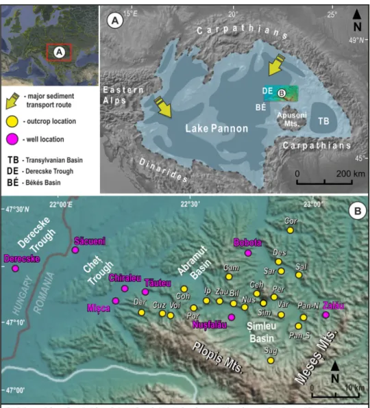
The Şimleu Basin (Fig. 1) is located between the central Pannonian Basin and the Transylvanian Basin. Geographi- cally, it is bounded by the Plopiș and Meseș Mts. in the SW and SE, respectively, whereas its rolling hills pass into the flat landscape of the Great Hungarian Plain towards the E and NE (Fig. 1B). The present topography has a relatively high altitude of 120–320 m above the level of the Great Hungarian Plain as a consequence of the lithospheric-scale uplift of the Transylvanian Basin (Krézsek and Bally 2006;
Tiliţă et al. 2013).
The evolution of the Şimleu Basin started with middle Miocene (Badenian) extension, resulting in deposition of foraminifera-bearing deep-water grey marls, while the over- lying shallow-marine carbonates and siliciclastics represent the onset of post-rift subsidence. The marine sedimentary record
is intercalated with felsic tuffs dated to 14.8–15.1 Ma (Szakács et al. 2012). The upper middle Miocene (Sarmatian) brackish- water deposits attain considerable thickness in some parts of the Şimleu Basin (Nicorici 1972; Clichici 1973). A short-term compressional event led to uplift and subaerial exposure, thus the upper Miocene (Pannonian) lacustrine deposits overlie unconformably on Sarmatian or crystalline basement rocks.
As neotectonic uplift is still ongoing, the landscape is changing quickly; hence, landslides detaching in Pannonian clays often create new outcrops and cover up older ones.
Materials and methods
Standard field observations, wireline log interpretation, and biostratigraphic correlation were integrated into a basin- scale stratigraphic and sedimentary model. More than 20
Fig. 1 Geographical position of the Pannonian Basin (A) with simplified bathymetry of Lake Pannon and directions of major shelf progradations and the Șimleu Basin (B) and neighbouring subsurface fea- tures with the studied outcrops and well locations. For the coordinates of the outcrops, see Supplement 1
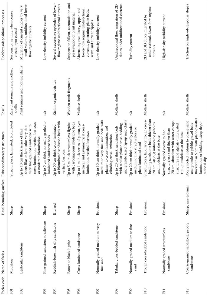
Table 1 Sedimentary facies and depositional processes Facies codeName of faciesBasal bounding surfaceFabric/sedimentary structuresFossilsBedforms/depositional processes F01MudstoneSharpStructureless, laminated, bioturbatedRare plant remains and mollusc shellsSuspension settling when coarse clastic input ceased F02Lenticular sandstoneSharpUp to 10 cm thick series of thin sheet-like or lenticular very thin, very fine-grained sandstone with cross-lamination, vertical burrows or moderate bioturbation
Plant remains and mollusc shellsMigration of current ripples by very small volume, unidirectional lower- flow regime currents F03Fine-grained sandstone to siltstoneSharpUp to 5 cm thick normally graded to laminated sandstone bedsn/aLow-density turbidity current F04Reddish-brownish silty sandstoneBlurredUp to 50 cm thick cross-laminated or bioturbated sandstone beds with vertical burrows
Rich in organic detritusSeveral successive episodes of lower- flow regime unidirectional currents F05Brown to black ligniteSharpUp to 5 m thick structureless lignite with carbonaceous mudstone bedsWooden trunk fragmentsSuspension fallout, accumulation and preservation of plant material F06Cross-laminated sandstoneSharpUp to 1 m thick series of planar, sym- metrical and asymmetrical cross- lamination, vertical burrows
Mollusc shellsAlternating oscillatory, upper- and lower-flow regime unidirectional currents, generating plane beds, wave and current ripples F07Normally graded medium to very fine sandErosionalUp to 10 cm thick normally graded medium to very fine sand beds with planar- to cross-lamination, and climbing cross-lamination n/aLow-density turbidity current F08Tabular cross-bedded sandstoneSharpUp to 20 cm thick sandstone beds with tabular planar cross-bedding and granule sized rip-up mud clasts
Mollusc shellsUnidirectional flow, migration of 2D dunes under unidirectional currents F09Normally graded medium to fine sandErosionalUp to 20 cm thick normally graded medium to fine structureless or plane laminated sand
n/aTurbidity current F10Trough cross-bedded sandstoneErosionalStructureless, tabular or trough cross- bedding sandstone beds thicker than 20 cm, a(t)b(i) imbricated pebbles and mudclasts at the base
Mollusc shells2D and 3D dunes migrated by unidirectional, lower-flow regime currents F11Normally graded structureless sandstoneErosionalNormally graded coarse to fine structureless sand thicker than 20 cm, abundant with water-escape structures and a(p)a(i) imbricated rip-up mudclasts at the base
n/aHigh-density turbidity current F12Coarse-grained sandstone, pebbly sandstoneSharp, rare erosinalPoorly sorted medium to coarse sand and granule to pebble gravel beds thicker than 5 cm with plane-parallel lamination or bedding, steep depo- sitional dip
Mollusc shellsTraction on angle-of-response slopes
outcrops were measured, and the facies were interpreted in terms of depositional processes (Table 1). The facies were grouped into facies associations to unravel architectural ele- ments of the depositional systems (Table 2). Wireline logs (typically old-vintage GR, SP, and resistivity) from eight wells were digitized and sedimentologically interpreted.
Characteristic log shapes of the typical Pannonian basin-fill formations were recognized (e.g. Juhász 1994; Pigott and Radivojević 2010; Sztanó et al. 2016). Finally, outcrop and well data from the Şimleu Basin were correlated through seismic profiles to the Der-I well in the central, deep Derec- ske Trough of the Pannonian Basin.
Fifteen samples of fossil molluscs were collected from eight outcrops, and the archive collection of the Paleontol- ogy-Stratigraphy Museum of the Babeş-Bolyai University, Cluj-Napoca (BBU) from three localities was also studied.
The 43 identified taxa are summarized in Supplement 2.
Micropaleontological samples were processed with hydro- gen peroxide from about 250 g of air-dried sediments.
Twelve samples were barren of ostracods but eleven samples from five outcrops contained ostracod carapaces and single valves, representing 14 taxa (Supplement 3). SEM images were taken at the Botanical Department of the Hungarian Natural History Museum in Budapest.
Facies analysis in outcrops
Facies association 1 (FA1a and FA1b): coarse‑grained deltas (Cehei, Porț and Sâg)
Description
FA1 conglomerates show a depositional dip of 10°–20°
(Fig. 2). Except for the lowermost boulders, which are made up of Sarmatian carbonates, the conglomerates in Cehei and Porț contain more than 95% mica-schist clasts derived from local sources (FA1a). In contrast, conglomerates near Sâg are polymictic with variable types of igneous, metamorphic, and carbonate clasts, thus indicating a larger, lithologically complex source area (FA1b).
In Cehei, FA1a unconformably overlies an erosional surface carved into the metamorphic basement with sev- eral meter relief, and it is capped by the horizontal beds of the muddy FA2. FA1a is a mixture of various sandy and gravelly facies units (Tables 1, 2). The most com- mon are 5–20-m thick bed-sets of massive, poorly sorted, imbricated, clast-supported conglomerates (F15), coarse- grained, fossiliferous, pebbly sands (F12), planar and trough cross-stratified sand (F10), and several-cm-thick mudstone interbeds (F02). The bed-sets consist of later- ally thinning beds with a thickness of a few decimeter, and dip towards the S–SW. Although there are lenticular units
Table 1 (continued) Facies codeName of faciesBasal bounding surfaceFabric/sedimentary structuresFossilsBedforms/depositional processes F13Matrix-supported mud-clast con- glomerateErosionalUp to 50 cm thick medium to coarse sand matrix conglomerate with a(p) a(i) imbricated rip-up mud clasts, soft-sediment deformation
n/aCohesive debris flow, incision or col- lapse of channel margin F14Matrix-supported gravel conglomer- ateErosoinalUp to 50 cm thick sand-rich medium to coarse sand matrix with gravel to boulder size quartz conglomerate with mica or limestone clasts, a(p) a(i) imbricated pebbles n/aCohesive debris flow F15Clast-supported gravelErosionalUp to 150 cm thick moderately sorted graveln/aGrain avalanche. high-density gravity flows
separated by erosional surfaces, most bed-sets show a con- vex geometry and downlap on older, flat bed-set bounda- ries or onlap on the slightly inclined ones (F02), revealing the delicate architecture of foreset terminations.
In the Sâg outcrop (FA1b), the steeply inclined fore- sets are built by gravelly matrix-supported conglomerate (F14) beds that show a depositional dip of 10°–20° to the N–NW and are overlain by less steep beds of pebbly sand,
Table 2 Facies associations Facies asso-
ciation code Facies associated Depositional system, element Location
FA1a F02, F08, F12, F15, Locally-sourced coarse-grained delta foresets below wave base Cehei, Porț FA1b F06, F08, F10, F12, F14, Locally-sourced shallow-water coarse-grained delta with foresets
above wave-base Sâg
FA2 F01, F02, F03, F07, F09 Profundal/open lacustrine Varșolț, Cehei
FA3 F01, F03, F07, F09, F11, F13 Turbidite channels and lobes Panic
FA4 F03, F04, F06, F08, F10 Delta front Nușfalău, Bilghez, Ip,
Pericei, Zăuan, Camăr, Sălăjeni
FA5a F02, F04, F05, F06 Lower delta plain (interdistributary-bay fill) Camăr, Bocșa, Sărmășag, Ip
FA5b F01, F05, F08, F10 Upper delta pain (with marsh) Derna, Voivozi, Cuzap
FA6 F06, F10 Fluvial channels Corund, Derșida, Cohani
Fig. 2 A, B NW–SE panoramic view of the Cehei quarry. C Detailed architecture of depositional lobes. Rose diagram shows dip of inclined beds and reflect paleotransport directions
commonly interfingering with trough cross-stratified pebbly sand (F12). The overlying flat, fine-grained sand is charac- terized by cross- or planar lamination and trough cross-strat- ification (F06 and F10), and alternates with pebble strings.
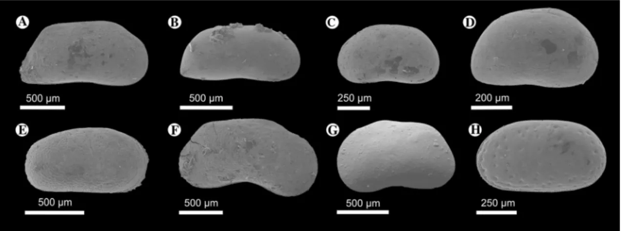
Fossils recovered from the pebbly sand (F12) in Cehei include Melanopsis fossilis and Congeria hemiptycha. The fine-grained intercalations (F02) in Cehei and Porț yielded poorly preserved Congeria cf. czjzeki, C. cf. banatica, Paradacna sp., Lymnocardium sp., Melanopsis sp., Gyrau- lus sp., and moderately or poorly preserved ostracods, such as Amplocypris bacevice (Fig. 3a), A. abscissa, Candona (Thaminocypris) aff. labiata (Fig. 3c), Herpetocyprella hieroglyphica (Fig. 3f), and H. auriculata (Fig. 3g).
Interpretation
Debris flows, grain avalanches and grain flows alternated on the steep, gravelly, sandy foresets. Lobe switching resulted in deposition of mudstones, followed by the onlap/downlap of new lobes. Upwards, with decrease of dip angle and on the flat lying topsets, bedload was deposited as small dunes in shallow channels and as downstream migrating bars. This facies association is interpreted as steep front of Gilbert-type deltas and their delta plain (cf. Postma 1990; Nemec 1990;
Gawthorpe and Colella 1990).
The Cehei outcrop reveals the toe and lower portion of foresets, which were covered by offshore mudstones when base-level rise outpaced the locally high sediment input. In the Sâg outcrop, the sediment transport mecha- nism was dominated by traction of bed-load, evidenced by the dm-scale trough cross-stratification and the low-angle crude-stratification of gravel and sand. The a(p)a(i)-type
imbrication in the gravel indicates mass-flow events (cf.
Postma 1990). The interfingering of gravel with cross- stratified and sheet-like sands demonstrates the lateral variability of the mouth bars near the topset-foreset tran- sitional zone. Upper-flow regime structures and erosional surfaces point to the effect of occasional floods. Unidirec- tional currents created shallow channel-form architecture.
Wave-induced ripples also occur in this shallow-water topset environment.
The foresets of the Sâg Gilbert-type delta and the chan- nel-fill sediments show the same transport direction towards the N–NW. Based on the progradational directions and the mixed composition of the clasts, the sediment source was in the S–SE, in Plopiș Mts.
The Porț and Cehei outcrops show a slightly different dep- ositional setting. The moderately sorted monomictic gravelly bed-sets in Cehei show convex downlapping geometry and can be interpreted as a lower segment of deltaic lobes, below wave-base, near the foreset-bottomset transitional zone. In Porț, the pebbly sand and massive graded pebbly sandstone of the delta slope might have been transported by short- distance gravity-flows initiated by fluctuating discharge and sediment charge of the feeding local fluvial systems (Gobo et al. 2015).
Fossils of the littoral dwellers Melanopsis fossilis and Congeria hemiptycha (e.g. Pavlović 1928) in the sand of the Cehei outcrop were probably reworked from the eroded topsets. The molluscs and ostracods of the clay-rich inter- calations indicate a sublittoral environment with low-energy conditions (e.g. Cziczer et al. 2009). These deposits formed by fallout from suspension and capture periods when active transport occurred on other lobes in laterally offset positions.
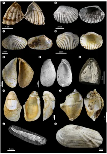
Fig. 3 Pannonian ostracods from the Şimleu Basin. a Amplocy- pris bacevice Krstič, 1973, right valve (RV) in lateral view, Cehei, MIK-27; bAmplocypris abscissa (Reuss, 1850), RV in lateral view, Nușfalău, MIK-20; cCandona (Thaminocypris) aff. labiata (Zalányi, 1929), left valve (LV) in lateral view, Cehei, MIK-28; dCandona sp.
juv., RV in lateral view, Varsolţ 1, MIK-30; eCyprideis heterostigma
Pokorný, 1952, RV in lateral view, Nușfalău, MIK-20; fHerpetocy- prella hieroglyphica (Méhes, 1907), RV in lateral view, Cehei, MIK- 28; gHerpetocyprella auriculata (Reuss, 1850), RV in lateral view, Cehei, MIK-28; hCyprideis pannonica (Méhes, 1908), LV in lateral view, Ip, MIK-13
Facies association 2 (FA2): open‑water lacustrine marls (Varșolț and Cehei)
Description
FA2 is dominated by mudstones (F01). In the uppermost part of the Cehei outcrop, bioturbated and laminated clay overlays the FA1a gravels (Fig. 2B).
A more than 40-m-thick succession of FA2 is exposed in the Varșolț claypit (Fig. 4), where neither the under- nor the overlaying beds are exposed. It consists of brownish- grey, cm-thick, laminated or bluish grey, structureless clay beds (F01), which contain mm-thick silt and up to 20 cm- thick very fine sandstone intercalations (F02, F03, F07, F09) with erosional base, normal gradation and planar- to cross-lamination. Sharp-top sandstone intercalations and
rare clay-filled vertical burrows of mm size also occur. The frequency and thickness of silty-sandy interbeds increase upwards (Fig. 4A, B). The paleocurrent directions meas- ured from ripples indicate a NW–SW sediment transport.
FA2 in Varșolț contains a low abundance and poorly preserved mollusc assemblage consisting of thin-shelled forms, such as Congeria banatica (Fig. 5g), C. cf. czjzeki, Lymnocardium winkleri, Paradacna syrmiense, Gyraulus praeponticus, Orygoceras fuchsi (Fig. 5j), Micromelania striata and Socenia acicula. Micropaleontological sam- ples from the Vârșolț claypit yielded mostly thin-shelled, juvenile ostracods and some broken, smooth adult valves belonging to Amnicythere sp., Amplocypris sp., and Can- dona sp. (Fig. 3d). The Cehei sample contained Amplocy- pris abscissa, Candona (Thaminocypris) sp., and Herpe- tocyprella sp.
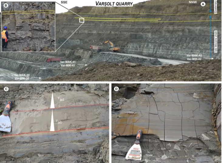
Fig. 4 The 40 m thick succession of the Varșolț clay pit. A Panoramic view of the mine, with indication of the paleontological samples. The frequency of silty-sandy interbeds, as well as the thickness of these beds increases upwards. : Close view of the marl with an intercalated
sand layer. C Medium-bedded turbidites, associated with bioturbated mudstone. Tab and Tad: recognized Bouma-sequences. D Laminated mudstone
Interpretation
Based on the sedimentary facies, FA2 was deposited rela- tively far from the sediment supply system, where deposition was mostly related to suspension fallout. The offshore mud- stones in the upper part of the Cehei outcrop were formed when base-level rise outpaced the locally high sediment input, thus transgression of the shores resulted in the full flooding of the local island.
The clayey succession at Varșolţ points to different events. The laminated character of the clay, as well as the low abundance of molluscs and ostracods indicate alter- nations of dysoxic and aerated bottom conditions. The
mollusc fauna consists of species that were adapted to the profundal habitats of Lake Pannon (e.g. Geary et al.
2000). The dominance of early juvenile ostracod speci- mens over adult ones is commonly observed in profundal zones of recent lakes, due to the high mortality rate of instars, transported from the shallower region, under the cold, temporarily oxygen-depleted bottom water condi- tions (Zhai et al. 2015).
The thin silty to sandy intercalations and the normally graded sand beds are interpreted as products of low-vol- ume, low-density, silty to sandy turbidity currents. Non- gradational sharp-top sandstones may indicate bypassing high-energy turbidity currents. The upward increasing frequency and thickness of the turbidites point to gradual increase of clastic sediment input at the Varșolț section.
The continuous sheet-like geometry of the sand beds may reveal either an area very far from distal lobes on the basin floor, or an overbank far from the main slope-channel. The latter option is supported by regional dip observations and the stratigraphic position between outcrops of turbidites and delta-lobes.
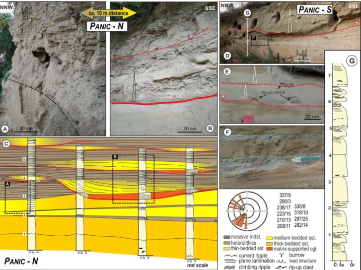
Facies association 3 (FA3): turbidite channels and lobes (Panic‑N and Panic‑S)
Description
FA3 is formed by several-meter-thick successions of sandstones (F09 and F11), conglomerates (F13) and het- erolithic alternations of thin sandstones (F03, F07) and mudstones (F01) (Table1). Panic-S and the lower part of Panic-N are sand dominated with a set of related struc- tures, including erosive base, normal gradation, structure- less sand containing rip-up mud clasts, horizontal- and cross-lamination, climbing cross-lamination and water- escape structures. Lateral and vertical facies changes are common in the upper part of Panic-N (Fig. 6A–C), consist- ing of heterolithics (F01, F03), medium-bedded sandstone laterally transforming into thin-bedded sandstone (F07) and matrix-supported mud-clast conglomerates (F13). The sandstones show channel-form geometry: their width var- ies between 2 and 10 m, while the depth of scouring is up to 1 m. The large (1–40 cm in diameter), rounded to angu- lar, imbricated rip-up mud clasts, floating in medium- to coarse-grained sandstone matrix, are situated above the erosional scours. The mud clasts consist of the heterolith- ics (F01, F03) and display soft-sediment folding.
Only a very few, small, indeterminate shell fragments of molluscs and plant remains were found in these sands.
Paleocurrent measurements from ripples indicate a west- ward sediment transport (Fig. 6).
Fig. 5 Pannonian molluscs from the Şimleu Basin. aLymnocardium cf. schedelianum (Fuchs, 1870), Nușfalău, MAK-19; b Lymnocar- dium edlaueri Papp, 1953, Nușfalău, MAK-19; c Lymnocardium hantkeni (Fuchs, 1870), Nușfalău, MAK-19; dLymnocardium con- jungens (M. Hörnes, 1862), Nușfalău, MAK-19; eCongeria simulans Brusina, 1893, Nușfalău, MAK-19; fDreissena auricularis (Fuchs, 1870), Nușfalău, MAK-19; g Congeria banatica R. Hörnes, 1875, Varșolț 2, MAK-41; hCongeria hemiptycha Brusina, 1902, Nușfalău, MAK-19; iMelanopsis vindobonensis Fuchs, 1870 (transitional form to “M. vindobonensis karagacensis” Pavlović, 1927), Nușfalău, MAK-19; j Orygoceras fuchsi (Kittl, 1886, Varșolț 1, MAK-30; k Pseudunio flabellatiformis (Grigorovich-Beresovsky, 1915), Derșida, BBU #15.249
Interpretation
Most facies in the Panic outcrops (F03, F07, F09, F11, and F13) reveal sediment gravity flows. Very thin-, medium- and thick-bedded turbidites, some with Ta, Tcd or Tabcd Bouma-sequences indicate transport by low- and high- density turbidity currents, respectively. As bed thickness decreases, Tcd becomes more common. Thick-bedded mud-clast conglomerates are interpreted as debrites occurring usually not far from the slope (cf. Lowe 1982;
Walker 1992; Talling et al. 2012). Low-relief erosional scours, thick, amalgamated, and laterally continuous beds with dewatering structures and climbing ripples indicate rapid accumulation of the sandy sediments, and point to a proximal lobe axis either between channels or in a very shallow aggrading channel. In contrast, the upper part of Panic-N succession is characterized by small yet distinct erosional scours, with a complex channel-fill lithology.
The scours were formed by bypassing high-energy erosive currents. High-density currents eroded mud clasts from the previous channel margins or inner levees, and suppressed turbulence led to rapid freezing and deposition (cf. John- son et al. 2001). The overlying normally graded, medium- bedded turbidites are associated with waning currents (cf.
Kneller and Branney 1995). Thin-bedded turbidites indi- cate the termination of the filling phase. These repeated cut-and-fill successions are interpreted as channel-fill sto- rey elements developed by cyclic waxing and waning flows driven by climate forcing in the endorheic lake (cf. Tőkés et al. 2021).
Taking into account the presence of massive lobate sands associated with scour-fills of mixed origin and internal lev- ees, we assume that the deep-water sediments near Panic were deposited in the proximal part of a turbidite system, probably close to the channel-lobe transitional zone (e.g.
Postma et al. 2016; Brooks et al. 2018).
Fig. 6 Facies association of the Panic outcrops. A Metre-thick-bed- ded turbidites in the NNW end of the Panic-N outcrop. B Normally graded metre-thick-bedded turbidites in the SSE end of the Panic-N outcrop. C Interpreted panel of sedimentary logs of the outcrop of
Panic-N (not to scale) and rose diagram on the measured paleotrans- port directions. D, E Outcrop of Panic-S. Normally graded meter- thick-bedded turbidites (D) and rip-up mud clasts overlay the ero- sional scours (E). G Sedimentary log of the Panic-S outcrop
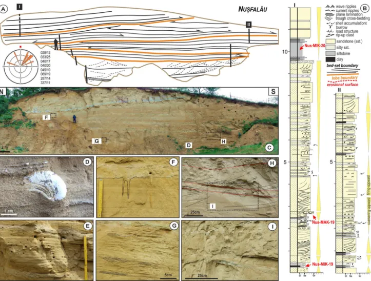
Facies association 4 (FA4): delta front (Nușfalău, Bilghez, Ip, Pericei, Zăuan, Camăr and Sălăjeni) Description
Deposits of FA4 form 5 to 15 m thick, sand-dominated, coarsening upward successions. In Nușfalău, Pericei and Zăuan, sandstone bed thickness varies between a few cen- timeters and a few meters, while mudstones are a few dm thick. The fine-grained intervals consist of horizontally laminated silty mudstone (F01) and interbeddings of very fine-grained sand (F02, F04, F06) with abundant small shell fragments and vertical burrows (Fig. 7F). In the over- lying, commonly wedge-shaped sandstones, a wide variety of sedimentary facies occur. The thin beds show plane- parallel lamination (F02) and symmetrical and asym- metrical types of cross-lamination (F06) (Fig. 7G), which were formed by rapid flows and wave and current ripples,
respectively (Fig. 7E, F). Intensity of bioturbation varies in these beds, from distinct, sand-filled, simple vertical burrows of dm length and cm diameter, through moderate density of burrowing to full homogenization of the sedi- ment. The thick beds show tabular and trough cross-bed- ding (Fig. 7H) (F08, F10), but structureless, amalgamated, i.e., fully bioturbated beds also occur (Fig. 7F). Small mud clasts, plant debris, and shell fragments are common at the lower part of foresets (Fig. 7D).
The Camăr, Sălăjeni, and Ip outcrops are character- ized by thick, tabular and trough cross-bedded, medium- grained sandstones (F08, F10) containing mud clasts and coquinas at their base. These sand bodies display a low- relief channel shape, and interfinger with parallel-lami- nated fine-grained sand.
Above low-angle erosional surfaces, laterally con- tinuous, parallel-laminated or cross-bedded fine-grained
Fig. 7 The Nușfalău outcrop. A Schematic drawing of the Nușfalău outcrop with a rose diagram showing the measured paleotransport directions. B Two sedimentary logs (I and II, their locations in A)
with positions of the paleontological samples. C Panoramic view of the outcrop. D A Congeria hemiptycha specimen in the sand. E–I The observed sedimentary facies (see in text)
sandstone (F06, F08) bed-sets and thin mud layers with vertical burrows occur at Bilghez.
FA4 contains the most diverse mollusc fauna of all FAs.
Common taxa include Congeria hemiptycha (Figs. 5h, 7D), C. simulans (Fig. 5e), Dreissena auricularis (Fig. 5f), Lymnocardium conjungens (Fig. 5d), L. cf. schedelianum (Fig. 5a), L. edlaueri (Fig. 5b), L. hantkeni (Fig. 5c), Mel- anopsis bouei, M. vindobonensis (Fig. 5l), and small-sized hydrobiid snails. A poor benthic ostracod assemblage with well-preserved valves and carapaces and with more adult than juvenile specimens was recovered in Ip and Nușfalău, with Cyprideis pannonica (Fig. 3h) being present in all sam- ples. Other forms include Amplocypris abscissa (Fig. 3b), Cyprideis heterostigma (Fig. 3e), Amnicythere sp., Candona sp., Herpetocyprella sp., and Loxoconcha sp. juv.
Interpretation
FA4 is the most commonly exposed facies association in the Şimleu Basin (Table 2.). The sand-dominated, coarsening- upward sequences in Nușfalău, Pericei and Zăuan indicate an upward increasing water agitation by currents and waves, reflecting a change from the transitional zone to the fore- shore, with the dominance of current-induced structures.
The downlapping or wedge-shaped bed-sets with laterally varying thickness indicate lobate geometry, which is typical for the shallow-water mouth-bars of deltas (Martini and San- drelli 2015). The alternation of thin sandy and muddy beds, associated with different ripples and burrows, indicates the distal/lower delta-front, where the combined effect of waves and river floods prevail (Plink-Björklund and Steel 2004;
Carvajal and Steel 2009; Jorissen et al. 2018). The thick- ening of sand beds reflects delta front progradation as the increasing effect of river discharge (Olariu and Bhattacharya 2006). Sandy successions from erosional scours, coquina or mud-clast accumulations, overlain by thick cross-bedded sandstones represent channels on the mouth bars (cf. Jordan and Pryor 1992; Olariu and Bhattacharya 2006). The effect of waves was more pronounced on the lower delta front than on the upper one, therefore these deltas are classified as river-dominated. Yet, the parallel-laminated, sheet-like sand- stones at Bilghez deposited on a high-energy wave-modified bar top (cf. Reading and Collinson 1996; Schomacker et al.
2010), pointing to local variations.
The mollusc fauna of FA4 indicates some variety and patchiness in the depositional environment. The Ip fauna suggests a vegetated nearshore environment based on the dominance of small-sized melanopsids (e.g. Müller and Szónoky 1990). In Nușfalău, Sălăjeni, and Zăuan, higher- energy environment can be inferred from the abundance of the large-sized and thick-shelled molluscs (M. vindobonen- sis, C. hemiptycha, and L. cf. schedelianum). The Nușfalău fauna also includes Melanopsis with irregular, knobby
sculpture, described by Pavlović (1928) from Vrčin, Serbia as M. vindobonensis karagacensis (Fig. 5i). We assume that this unusual pattern is a paleopathological feature rather than an ecological response.
The ostracod genus Cyprideis is known to prefer the littoral zone in marine and lacustrine environments (e.g.
Morkhoven 1963; van Harten 1990; Boomer et al. 2005;
Beker et al. 2008; Stoica et al. 2013). Its massive, less ornate carapace may reflect adaptation to high-energy bottom water conditions and to the sand-dominated substrate.
Facies association 5 (FA5a and FA5b): lower and upper delta plain (Derna, Cuzap, Șărmășag, and Voivozi)
Description
FA5 is composed of alternating mud- and sand-prone facies, with very thin lignites in FA5a and mineable ones in FA5b.
In the central part of the basin, at the outcrops of Nușfalău, Camăr, Bocșa, Șărmășag and Ip, FA5a overlies FA4 and consists of alternating layers of clay (F01), laminated silty sand (F04), and cross-laminated fine-grained sand (F06) with 2–3 mm wide and a few cm long, sand-filled vertical burrows. It comprises a few meter-thick, coarsening upwards units, topped by organic-rich clays or cm-thick lignite seams (F05) (Table 1).
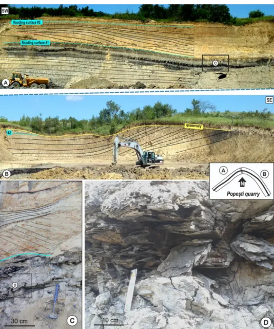
In the open-pit lignite mines of Derna, Voivozi, and Cuzap, FA5b is exposed as 3–10-m thick mudstone-dom- inated successions (F01) with thick intercalations of cross- bedded, very coarse, pebbly sand (F08, F10) and lignite beds (F05) up to a thickness of 0,5–3 m (Fig. 8). Coalified logs (Fig. 8D) and leaf imprints are well preserved. The sandstones form up to 10’s of metres wide and 2–6 m thick channel-forms or mounds (Fig. 8A). The succession directly overlies the crystalline basement at the NW tip of the Plopiş Mts.
Interpretation
The mudstones with thin sandy interbeds filled the interd- istributary bays of the lower delta plain during subsequent floods, resulting in the formation of swamps (Table 2). Thick cross-bedded sands formed as active distributary channel fills, while organic-rich deposits represent abandoned chan- nels, ponds or swamps on the upper delta plain. Distribution of sediments and thickness of lignites on the delta plain was strongly influenced by compaction-related subsidence (cf.
Phillips and Bustin 1996; Reading and Collinson 1996).
A specimen of the pearl mussel Pseudunio flabellati- formis from Derna (BBU #15.273) indicates a freshwater- fluvial environment. Lubenescu et al. (1967) reported a small fauna with Tinnyea vasarhelyii and small- and large-sized
melanopsids from the Șărmășag locality, suggesting a well- vegetated environment with changing salinity conditions.
Facies association 6 (FA6): fluvial channels (Corund, Derșida, and Cohani)
Description
FA6 is composed of medium- to coarse-grained sandstone and subordinate mud layers. The Cohani outcrop displays a 20–25 m thick succession of laterally discontinuous, trough cross-bedded, coarse-grained sandstone (F10) and tabular cross-bedded sandstone (F08) packages. Thickness of the bed-sets varies between 0.4 and 1.5 m. Above the basal sur- faces, imbricated pebbles occur. Some thin-bedded, silty, very fine sand beds (F06) are associated with completely weathered tuff horizons. Pieces of silicified wood fragments
also occur. Sandstone series are bounded by major erosional surfaces with a relief of 2 m. Similar cross-bedded sandstone occurs in the small Corund outcrop.
Interpretation
The cross-bedded sets, separated by erosional surfaces, rep- resent vertically and laterally stacked, aggradational multi- storey fluvial channel-fills (cf. Collinson 1996). Each sto- rey contains channel-fill bars separated by minor erosional surfaces. The fine-grained sediments are restricted to the bar tops. Mudstones of the surrounding floodplains are not exposed.
Various fossils were reported from Derșida (Paucă 1954; Maxim and Ghiurcă 1960, 1963, 1964; Codrea et al.
2002; Codrea and Margin 2009), but we failed to iden- tify their exact locality in the field. Maxim and Ghiurcă
Fig. 8 Voivozi quarry. A, B SW–NE oriented photos of the mine with the interpreted flooding surfaces and prograda- tional lobes. C Close view on delta plain marsh sediments and flooding surface #1. D Lignite layer with trunks within the marsh sediment
(1960) reported a mixed mollusc fauna, consisting of land (Cepaea), freshwater (Unio, Viviparus, Lithoglyphus, Val- vata, Lymnaea, Planorbis, and Planorbarius), and brack- ish-water (Melanopsis) elements. The BBU material from Derșida (collected and determined by Maxim and Ghiurcă 1960) contains 41 specimens of the fluvial Pseudunio fla- bellatiformis and an indeterminate Melanopsis species (#15.247–15.272 and 15.274–15.280).
Correlation of facies associations to the subsurface
The depositional systems represented by the exposed facies associations are also recognized in the subsurface. In the Săcueni, Bobota, Mișca, Tăuteu and Chiraleu wells, serrated and blocky log shapes indicate coarse sand and conglomer- ate of up to 20–50 m thickness, overlying the crystalline basement or middle-Miocene deposits. These correspond to FA1 recognized in outcrops. Elsewhere the lacustrine sedimentary record starts with about 30 m thick offshore marls (FA2).
Above the marls, up to 30 m thick blocky and barrel- shaped sandstone sequences separated by 2–10 m thick mud- stones occur in the Zalău, Nușfalău and Săcueni wells. These are interpreted as sand-prone lobes of a turbidite system. The corresponding FA3 in outcrops of Panic show the channel and/or channel-lobe transitional zone.
The overlying, up to 300 m thick unit, being present in all wells of the study area, displays smooth or finely serrated log shapes. It is interpreted as mudstones deposited on the
shelf-edge slope (FA2). It thickens to 400–700 m towards the basin interior in the west west (Săcueni, Chiraleu).
Funnel log shapes correspond to 20–50 m thick coarsen- ing upward successions and reveal prograding sandy delta lobes (FA4 and FA5) representing the upper part of the basin fill.
The youngest unit of the upper Miocene lacustrine sequence shows a serrated log pattern interrupted by up to 20-m thick intervals of bell and blocky log shapes. These are interpreted as representing a clayey-silty alluvial plain, cross-cutted by sandy channel-belt deposits (e.g. FA6, Cohani). The thickness of this unit increases to 500 m west- wards in the Cheţ and Derecske Troughs (e.g. Chiraleu).
Biostratigraphy and age
Earlier mollusc biostratigraphic studies from the Şimleu Basin correlated the lacustrine succession with the lower part of the Pannonian, stressing that the oldest Pannon- ian biozones are missing in the area (Matyasovszky 1879;
Lubenescu et al. 1967; Marinescu 1985; but see Chivu et al.
1966).
The low-diversity mollusc fauna recovered from the coarse-grained deltas in Cehei is indicative of the Lym- nocardium conjungens Zone (11.0–9.6 Ma; Fig. 9). The bivalve Congeria hemiptycha (also known by its junior synonym as Congeria pancici Pavlović 1927) first appears in “Zone D” of the Vienna Basin (Papp 1985), which was dated 10.6–10.4 Ma by Harzhauser et al. (2004). The
Fig. 9 State-of-the-art biozonation of Lake Pannon deposits with the age of the studied Pannonian localities of the Șimleu Basin. Mol- lusc zonation follows Magyar and Geary (2012), ostracod zonation is modified after Krstić (1985). Paleomagnetic chrons and European Neogene mammal biozones are used after Hilgen et al. (2012). Blue
line indicates profundal, green sublittoral, red littoral, and purple freshwater-fluvial environment. Turquoise bracket shows the 10.6–
9.6 Ma time interval supposed for the main transgressive–regressive cycle in the Șimleu Basin
age of the Cehei conglomerates and sandstones is thus restricted to the interval of 10.6–9.6 Ma (Fig. 9).
The profundal fauna of the offshore lacustrine marls (FA2) in Vârșolț belongs to the Congeria banatica Zone (~ 11.45–9.6 Ma; Fig. 9). In an outcrop SE of Nușfalău, Papp (1915) found a well-preserved specimen of Lymno- cardium soproniense (“L. penslii”), together with Con- geria banatica and C. partschi in “sandy marl” that under- lies the fossiliferous deltaic sediments at Nușfalău. This finding indicates the L. soproniense Zone (10.2–8.9 Ma;
Magyar et al. 2016; Fig. 9).
Based on the common occurrence of Lymnocardium conjungens, L. hantkeni, Congeria hemiptycha, Melano- psis vindobonensis etc. (see in Lőrenthey 1893; Strausz 1941; Lubenescu et al. 1967; Nicorici and Karácsonyi 1983), the shallow-water lacustrine deltaic sands (FA4 and FA5) belong to the upper part of the Lymnocardium conjungens Zone (ca. 10.2–9.6 Ma; Fig. 9). The appear- ance of Dreissena auricularis in these assemblages, how- ever, points to the youngest part of this zone. Papp (1950) postulated that D. auricularis evolved from Congeria git- neri, and the stratigraphic distribution of these two species in the western part of the Pannonian Basin is in accord with this hypothesis (Magyar et al. 1999b). The earliest occurrence of D. auricularis in Pezinok (Horusitzky 1907) was dated by mammal stratigraphy as early MN10, ca.
9.6–9.7 Ma (Joniak 2016).
The ostracod Amplocypris abscissa, occurring in FA1 and FA2 in Cehei and in FA4 in Nușfalău, was considered by Krstić (1985) as a biostratigraphic marker of the Amplo- cypris abscissa and the overlying Hemicytheria croatica zones. A. abscissa occurs in the Hennersdorf outcrop next to Vienna (Danielopol et al. 2011), which was interpreted by Harzhauser et al. (2004) as being 10.2–10.4 Ma old.
The most common fluvial mussel, Pseudunio flabel- latiformis, is well-known from the fluvial deposits of the Pannonian Basin throughout the entire late Miocene (as
“Unio wetzleri” or “Margaritifera flabellatiformis” in the older literature; here we follow the revision of Lyubas et al. 2019); thus, it does not constrain the age of FA5 and FA6 occurrences. In Derșida and in the lignite-bearing deltaic layers of Derna, however, Anancus arvernensis remains were found (Codrea and Margin 2009; Gasparik pers. comm. 2020). The oldest known European occur- rences of this large-sized mastodon are Messinian (MN12, from 7.2 Ma on; Konidaris and Roussiakis 2018). This dating implies a significant stratigraphic gap between the older-than-9.6-Ma lacustrine and the younger-than-7.2-Ma fluvial deposits, but this gap is not supported by our field observations. This contradiction thus remains unresolved until a more detailed study of the unconformities in the area or a revision of the large mammal stratigraphy brings along new perspectives.
Changes of the depositional environment
The oldest lacustrine sediments exposed in the study area are the coarse-grained conglomerates and sandstones, deposited in locally-sourced progradational Gilbert-type deltas that rimmed the islands during the initial flooding of the Șimleu Basin (Fig. 10A). Their age is known only at Cehei (10.6–9.6 Ma), but they could have developed diachronously along the margins.
The coarse-grained deltas show various paleotransport directions depending on their sources (Fig. 10E). The pol- ymict conglomerates at Sâg confirm that some parts of the Apușeni Mts. (e.g. Plopiș area) were elevated and subaeri- ally exposed during the early late Miocene (Fig. 10A), as Nicorici (1972) and Clichici (1973) postulated formerly.
The monomict systems (Cehei) were sourced from inverted metamorphic basement horsts. All these coarse-grained deltas could have been intimately associated with active fault scarps (cf. Colella 1988; Gawthorpe and Colella 1990; Sztanó et al. 2010).
As base-level rose and islands submerged, offshore mudstones were deposited by suspension fallout. These preserved the fossils of the profundal Congeria banatica fauna, which was widespread in Lake Pannon between ca.
11 and 9.6 Ma (e.g. Botka et al. 2019). The low abundance and low diversity of the fauna indicate a partially isolated, oxygen-depleted deep-water environment (Fig. 10B).
The first distally sourced clastics, indicating the onset of regression in the Șimleu Basin, were thin-bedded tur- bidites in the upper part of the profundal mudstones.
The coeval slope might have prograded from E or SE (Fig. 10B), implying that the Meseș Mts. was not a con- fining barrier at that time: the central Pannonian Basin and the Transylvanian Basin were geographically connected through the Șimleu Basin.
A more robust evidence of the ESE to WNW advanc- ing slope progradation is provided by the sandy turbid- ites at Panic, which can be interpreted as lobe axis and/or lobe-channel fill deposits (Fig. 10C). Few 10 s of metre thick stacked turbidite sequences also appear in wells near Zalău, Nușfalău, Bobota, Chiraleu, and Săcueni. The rela- tively small thickness, coupled with the probably large extent of these sand lobes is typical for unconfined toe- of-slope turbidite systems (cf. Sztanó et al. 2013b; Tőkés and Patacci 2018).
Turbidites are overlain by 200–300-m thick mudstones (Nusfalău and Bobota wells), which can be attributed to the slope. A seismic section from Căuaş, 25 km to the N (Fig. 7 in Ciulavu et al. 2002), displays ca. 150 m high clinoforms. Progradation of similar, relatively small clin- oforms might have filled the Şimleu Basin rapidly. The advance of the shelf-edge was supplied by river-dominated
Fig. 10 Late Miocene (10.6–9.6 Ma) basin-fill history of the Șimleu Basin. TRG trans- gression, REG regression. A Ca. 10.6 Ma ago, Lake Pannon flooded the study area. Some basement blocks became islands and provided sediment for Gilbert deltas. B Transgression created widespread open- and deep lacustrine environment and basement highs were flooded by ca. 10.2 Ma. C Infilling of the basin started from the NE by deposition of turbidite lobes. D The shelf-edge slope prograded from E to W across the Simleu Basin not later than 9.6 Ma ago. E Paleotransport directions based on field data in the Şimleu Basin. F Timing of shelf-edge progradation in Lake Pannon (after Magyar et al.
2013)
deltas at around 9.7–9.6 Ma. Measurements indicate pale- otransport directions to WNW and NW, i.e. towards the central parts of Lake Pannon (Fig. 10E).
Based on outcrop data, the thickness of individual deltaic parasequences varies between 3 and 10 m, and they build up to 50 m thick deltaic sequences displayed by well-logs. The height of the parasequences and deltaic bodies in the Șimleu Basin is in the same range as in the paleo-Danube or paleo- Tisza systems (Juhász 1994; Sztanó et al. 2013a; Magyar et al. 2019). These packages indicate moderate-amplitude short-term base-level changes and/or autocyclic avulsions of the feeding rivers.
Correlation and comparison with the central Pannonian Basin
Both the eastern part of the deep, central Pannonian Basin and the Şimleu Basin were filled by sediments derived from the Eastern Carpathians. Their evolution was parallel, but infill of the Pannonian Basin lasted for ca. 7 million years (Magyar et al. 2013), while that of the Şimleu Basin took only less than 1 million years. To understand the role that the Şimleu Basin played in the infill of the large system, correlation was established to the Derecske Trough, one of
Fig. 11 W–E geological cross-section from the Derecske Trough to the Meseș Mts. based on seismic, borehole, and outcrop data
Table 3 Stratigraphic thicknesses of Pannonian formations and estimated sedimentation rates in Derecske Trough (well Derecske-I) and Şimleu Basin
Formation Depositional setting Derecske-I Nușfalău
Approx. age (Ma) Thickness Sed. rate m/Ma Approx. age (Ma) Thickness Min. sed.
rate m/Ma Quaternary + Zagyva + Újfalu
Upper Fluvial 8.6–0 1750 203
Újfalu Lower Stacked delta lobes 11.6–8.6 100 987 10.6–9.6 300 650
Algyő Slope 1250 200
Szolnok Turbidite sytem 1050 100
Endrőd Profundal marl 560 30
Békés Coarse-grained deltas 0 20
the deepest depocenters of the Pannonian basin ca. 70 km to the W of the Şimleu Basin (Fig. 11).
The base of the Neogene gradually ascends from several hundred meter depth in the Şimleu Basin to more than 5 km in the Derecske Trough. The largest throw is observed at the Suplacu de Barcău fault zone, which played a crucial role in the accumulation of the Suplacu oil field, one of the largest in the Pannonian Basin (e.g. Panait-Patica et al. 2006).
Exploration wells in the region are generally located above the basement highs, such as the Chiraleu and Săcueni highs, whereas the basin interiors are mostly known from seismic data (Fig. 11). The 5200 m deep Derecske-I hydro- carbon exploration well (“Well-5” in Vakarcs et al. 1994) was drilled close to the center, yet the deepest part of the basin was not reached (Balázs et al. 2016).
The late Miocene lacustrine succession in the Derecske-I well (Table 3) starts with deep-water marls. The overlying basin-center confined turbidite system is made up of lobe complexes with paleotransport directions from NE to SW (cf. Sztanó et al. 2013b). These are overlain by slope depos- its, i.e. thin unconfined turbidites and monotonous mud- stones. The slope related clinoform height is ca. 650 m in the Derecske Trough (Balázs et al. 2018). It decreases to ca.
500 m in the Cheţ and Abrămuţ basins in the east, whereas in the Şimleu Basin it is not higher than 200 m. Considering compaction, the tallest slopes during deposition could have exceeded 1000 m height in the Derecske Trough (Balázs et al. 2018) and 300 m in the Şimleu Basin. Deltaic succes- sions are built up of 30–50 m thick, coarsening-upward lobe cycles. The overlying late Miocene to Quternary fluvial suit is extremely thick in the Derecske Trough. The elements of the lacustrine sedimentary succession are almost identical in the Derecske Trough and Şimleu Basin, except for their thickness and timing.
The clinoforms provide another aspect for comparison.
The direction of progradation was from E–SE to W–NW in the Şimleu Basin, as measured in the field within the turbidites and delta sediments. In contrast, in the eastern depocenters of the central Pannonian Basin, on both sides of the Hungarian-Romanian border, slope progradation was from N–NE to S–SW, as evidenced by seismic clinoforms (Tulucan 2007; Răbăgia 2009; Horváth and Pogácsás 1988;
Vakarcs et al. 1994; Lemberkovics et al. 2005; Magyar et al.
2013). This pattern indicates a mergence of different fluvial feeder systems immediately W of the Şimleu Basin. Similar features were observed in other parts of the Pannonian Basin as well (Pogácsás and Révész 1987; Magyar et al. 2013).
In an earlier study (Magyar et al 2013), seismic sur- faces were calibrated as biozone boundaries across the Pannonian Basin, and they were dated according to the biochronostratigraphic system of Magyar and Geary (2012) (Fig. 9). The 8.6 Ma surface, corresponding to
the base of the Lymnocardium decorum Zone, reaches the shelf edge 4 km to the SW of Derecske-I (Fig. 10F).
The correlation of this surface towards the Şimleu Basin is straightforward up to the Suplacu fault zone; coeval deposits in the Şimleu Basin, however, have been eroded (Fig. 11). This correlation sets a lower limit (a minimum) on the age of the lacustrine and deltaic succession of the Şimleu Basin. Thus, there is a 1 million-year time shift in the formation of the shelf edge and related facies asso- ciations between the Şimleu Basin and Derecske-I well.
The shelf-edge advanced across the Şimleu Basin at about 9.7–9.6 Ma, probably in a very restricted time interval (a few 100 kys at most). Between 9.7 and 8.7 Ma, the shelf-edge advanced ca. 70 km to the west, across the Abrămuţ Basin and Cheţ Trough to the Derecske Trough, into increasingly deeper water. This rate is similar to the rates observed in other parts of Lake Pannon (cf. Sztanó et al. 2013b) and in supply-dominated, moderately deep- water marine settings worldwide (Carvajal et al. 2009).
The shelf accretion was fed by deltas across the Şimleu Basin (at least up to 9.6 Ma). When delta lobes filled the available accommodation to lake level in the Şimleu area, deposition of turbidites occurred in a water depth some- what larger than 1000 m in the Derecske Trough. Thus, the late Miocene paleorelief can also be assessed from these data. The roughly estimated sedimentation rates in the studied successions of the Şimleu Basin and in the basin interior are on the same order (Table 3).
The outcrops of the relatively thin Pannonian succes- sion of the Şimleu Basin thus display the whole variety of processes that shaped the Pannonian Basin, including deep-water turbidite and slope formation. This pattern is noteworthy because most Pannonian outcrops expose only a limited segment of the basin fill. The most com- monly exposed units are either coarse-grained deltas at the base of the succession (Sztanó et al. 2010; Budai et al. 2019) or deltaic and fluvial deposits (e.g. Kováč et al. 1998, 2018; Sacchi et al. 1998; Uhrin and Sztanó 2007; Sztanó et al. 2013a; Magyar et al. 2017; Pavelić and Kovačić 2018), neither of which represent the full history of basin evolution. Generally, deep-water depos- its, such as offshore marls and turbidites, are particularly rare in surface outcrops (Kovačić et al. 2004; Krézsek et al. 2010; Bartha et al. 2015; Tőkés et al. 2021). The Şimleu Basin owes its uniqueness to its paleogeographic position close to the margin of the Pannonian Basin but well within Lake Pannon, to its subsidence and deepen- ing that was mostly coeval with that of the main basin, to its size and topography that allowed the formation of a deep-water environment, and to its early sedimen- tary infill that took place soon after the onset of normal regression of Lake Pannon.