Contents
1. Introduction ... 2
2. The development of the cross-border cooperation ... 7
2.1 Establishment of the Drina Euroregion ... 8
3. Determination of geographical confines ... 11
3.1 The Serbian–Bosnian border section of the Drina Euroregion ... 11
3.2 The Serbian–Croatian border section of the Drina Euroregion ... 12
3.3 The Croatian–Bosnian border section of the Drina Euroregion ... 12
3.4 The Montenegrin–Bosnian border section of the Drina Euroregion... 13
3.5 The Montenegrin–Serbian border section of the Drina Euroregion ... 14
3.6 Geographic features of the Drina Euroregion area ... 15
3.7 Administrative units – members ... 20
4. Organisational and institutional structure, operation ... 28
Assembly ... 28
President ... 29
Executive Board ... 29
Supervisory Board ... 30
5. Composition of the working organ ... 31
6. Main activity areas, profile ... 32
6.1 Activities of the Drina Euroregion ... 32
6.2 The residents’ opinion of the Drina Euroregion ... 35
6.3 Cross-border cooperation projects in the study area ... 36
7. Management ... 50
8. SWOT-analysis ... 51
9. Future plans and goals of the cooperation ... 54
10. Unique, regionally specific features of the cooperation ... 56
11. Summary ... 57
12. Bibliography ... 59
13. Annex ... 61
1. Introduction
This case study, dealing with the so-called Drina Euroregion is intended to illustrate institutionalised cross-border cooperation along the Serbian–Bosnian border. It is part of the project titled “Crossing the Borders” about the geographic and structural characteristics of cross-border cooperation in the Danube Region, led by CESCI – Central European Service for Cross-border Initiatives. The case study was elaborated in December 2014 and January 2015 by three researchers of the Regional Science Association (RTT) from Subotica, Serbia.
The task was the to prepare two separate case studies on cross-border cooperation (EGTC, Euroregion, twin cities etc.) which are institutionalised, have been established by cooperation between territorial administrative entities and do have development aspirations. Moreover, these examples have to present the border sections between Serbia and Croatia, Serbia and Montenegro, Serbia and Bosnia and/or Bosnia and Montenegro. The content requirements have also defined to choose such case studies that are the best examples of cooperation from a functional point of view: the collaboration intensifies cross-border relations, a kind of local identity can be dedicated to the area, the participants succeed in exploiting development funds, and their objectives contribute to the socio-economic development of the affected region.
Having in mind all these requirements, the authors of this paper have decided to find two different examples: one about regional cooperation, and another about the collaboration of two municipalities. This case study deals with the establishment and operation of the Drina Euroregion, while the other study is about the cooperation of the cities of Subotica from Serbia and Osijek from Croatia.
The reasons for choosing the Drina Euroregion as the best example of cross-border cooperation along the Serbian–Bosnian border are manifold. On the one hand, there were specific events in recent history taking place in the administrative units that initiated this cooperation, namely the Balkan wars of the 1990s, and on the other hand, the geographic, demographic, geopolitical and socio-economic changes resulting from setting new borders in this area. Yet there is the Drina River, which presents identical natural values on its both banks.
The Drina Euroregion is the youngest representative of this specific type of cross-border cooperation in the Western Balkans. It unites territorial entities of different administrative levels along the borders, which were set in the 1990s between four new countries, all of them being former member republics of the Socialist Federal Republic of Yugoslavia. Among the members of the Drina Euroregion there is a town1 from Croatia, a municipality2 from
1 Županja
2 Plužine
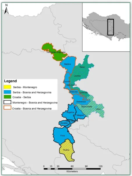
Montenegro, three towns3 and three municipalities4 from Serbia, a canton5 of the Federation of Bosnia and Herzegovina and further eight Bosnian municipalities6 (Figure 1).
Figure 1: Map of the Drina Euroregion Source: http://euroregijadrina.com/
Another specific structural feature of this Euroregion comes from the fact that these four countries are at different stages in their EU accession. Namely, Croatia is the newest, 28th member state of the European Union (since 1 July 2013), Montenegro and Serbia have already begun their pre-accession processes (Montenegro received official candidate status on
3 Užice, Loznica, Šabac
4 Bajina Bašta, Ljubovija, Mali Zvornik
5 Bosansko-podrinjski kanton Goražde
6 Foča, Novo Goražde, Rogatica, Višegrad, Srebrenica, Bratunac, Zvornik, Bijeljina
17 December 2010, while Serbia received full candidate status on 1 March 2013), whereas Bosnia and Herzegovina has only begun the Stabilization and Association Process (a bilateral SAA agreement has been signed in 2008, ratified in 2010, but it is still not in legal force).
Figure 2: The territory of the Drina Euroregion covered by different IPA Cross-border Cooperation programme areas
Source: RTT’s own compilation
The territory of the subject area lies in the Western Balkans, which is a southeastern European area including Croatia, Serbia, Bosnia and Herzegovina, Montenegro, Kosovo, Macedonia, and Albania. All of these countries are involved in the IPA Adriatic Cross-border Cooperation
Programme7 and the South East Europe Transnational Cooperation Programme,8 as well as five IPA cross-border programme areas of the European Territorial Cooperation (Croatia–Serbia;9 Serbia–Bosnia and Herzegovina;10 Serbia–Montenegro;11 Bosnia and Herzegovina–
Montenegro;12 Croatia–Bosnia and Herzegovina13). Figure 2 shows how these programme areas cover the territory of the Drina Euroregion.
One must take into consideration that this case remarkably differs from the other examples of cross-border cooperation from the Danube Region in many respects. The easiest way of illustrating this difference is to compare the level of cooperation and collaboration along the Iron Curtain in the early 1990s. This two-decade-long backwardness is present in all spheres of everyday life. There are too many historic wounds that cannot be healed in such a short time.
Having in mind the above, the establishment of the Drina Euroregion itself is a pleasant surprise and a prospective initiative.
Therefore, if we try to prop the above mentioned content requirements concerning the best examples of cooperation from a functional point of view, the expectations should not be exaggerated.
Firstly, the collaboration within the Drina Euroregion has intensified cross-border relations, but only compared to the previous situation at the end of the 20th century.
Secondly, a kind of local identity can be dedicated to the area, which is based on the Drina River and the population living along its banks. The natural, demographic and socio-economic conditions are very similar in the whole region.
Thirdly, when talking about development funds and their exploitation, it has to be stated that this is a question of the future, since there have been no considerable grants and development funds available for the actors of the observed area. In addition, even the available resources have not been exploited adequately. It is clearly visible when looking at the modest lists of projects from this area, which have been supported from EU sources.
Finally, it is also a requirement for choosing a case study that the formulated objectives should contribute to the socio-economic development of the affected region. In the case of the Drina Euroregion, even the fact of its establishment can be considered as a step forward, as the joint
7 http://www.adriaticipacbc.org/
8 http://www.southeast-europe.net/en/
9 http://www.croatia-serbia.com/en/
10 http://srb-bih.org/?lang=en
11 http://www.cbcsrb-mne.org/
12 http://www.cbc.bih-mne.org/
13 http://www.cbc-cro-bih.net/en/
formulation of common goals in preserving and utilising the river as a natural resource makes a good basis for any further development initiatives.
This introductory chapter is followed by a presentation of the cross-border cooperation; the events preceding and leading up to its establishment; the organisation, the management, the functioning, and the activities of the Drina Euroregion; and finally an insight into its future pathways. In order to provide a basis for analysing and understanding the future development of the Euroregion, we carried out a SWOT analysis (see chapter VIII) and listed the main points from the development program of the Drina Euroregion (see chapter IX).
As the main source of information presented in this study, we used the website of the Drina Euroregion (www.euroregijadrina.com) and its official documents. Moreover, we conducted personal interviews with Mr. Zdravko Krsmanović, the president of the Drina Euroregion as well as with 6 municipal officials and 17 local residents from the study area.
2. The development of the cross-border cooperation
The so-called Drina Euroregion unites territorial units of different administrative levels along the Drina River, which became divided by new state borders after the civil war in Yugoslavia during the 1990s.
The Croatian municipality of Županja (now the Town of Županja) became a border municipality towards Serbia and Bosnia after Croatia had formally declared its independence in June 1991.
The border between Bosnia and the Federal Republic of Yugoslavia, though unchanged, became the border between the Federal Republic of Yugoslavia and Bosnia and Herzegovina (Republika Srpska) in 1995. According to the Dayton Agreement14 the territory of Bosnia and Herzegovina is composed of the Federation of Bosnia-Herzegovina and of Republika Srpska.
Due to this division, the former settlement of Goražde has been divided, so Goražde (the Euroregion's member) in the Bosansko-podrinjski kanton belongs to the Federation, while the municipality of Novo Goražde is in the Republika Srpska. Finally in 2006, with the dissolution of the State Union of Serbia and Montenegro (formerly the Federal Republic of Yugoslavia between 1992 and 2003) the municipality of Plužine from Montenegro became a border settlement with Serbia and Bosnia and Herzegovina.
Presumably, there have been many injuries and huge sufferings caused by the state border changes of the past century. These events have burdened the relations between the nations living in this region; however, their common history within the same country – the Kingdom of Serbs, Croats and Slovenes from 1918, then the Kingdom of Yugoslavia from 1929, and finally the Socialist Federal Republic of Yugoslavia from 1945 to 1991 – together with their similar languages, cultural and family relations may speed up the cooperation of these four countries along the Drina River, within an institutional framework based on European principles.
Since this study is focused on cross-border cooperation along the Serbian–Bosnian border here follows an overview of this relation, based on the analysis of the Institute of International Sociology of Gorizia published in 2011.15
As we mentioned above, the relations between the Serbian and Bosnian states were set down in the 1995 Dayton Agreement, according to which the Federal Republic of Yugoslavia
14 The General Framework Agreement for Peace in Bosnia and Herzegovina, also known as the Dayton Agreement, Dayton Accords, Paris Protocol or Dayton-Paris Agreement, is the peace agreement reached at Wright-Patterson Air Force Base near Dayton, Ohio, United States, in November 1995, and formally signed in Paris on 14 December 1995. These accords put an end to the three and a half-year-long Bosnian War, one of the armed conflicts in former Yugoslavia. The agreement's main purpose was to promote peace and stability in Bosnia and Herzegovina, and to endorse regional balance in and around the former Republic of Yugoslavia.
15 Strategies and euroregions for cross-border co-operation in Balkan and Danube European countries. (2011) Institute of International Sociology of Gorizia (ISIG) http://isig.it/wp-content/uploads/2012/11/SWOT-Strategies- and-Euroregions-for-CBC.pdf (Downloaded: 28.12.2014) pp. 140-144.
(predecessor of Serbia) could establish special relations with the Republika Srpska on the basis of mutual interests with respect to the presence of a Serb majority in both countries. Since there are special institutional co-operation agreements already in force, the authors from ISIG claim that cross-border co-operation is at a satisfactory level.
Regarding territorial and environmental planning, the Drina River that flows along the border presents considerable potentials as a water reservoir, an energy source and a touristic attraction. As examples they mention the opening of new river ports on the Serbian side and the construction of the new rail segment between Valjevo in Serbia and Zvornik in Bosnia.
The intensity of cross-border mobility is fostered by the fact that the border between Serbia and Bosnia may be crossed without a passport. Educational and cultural cooperation is more problematic because the two systems differ greatly. For example, education in Bosnia and Herzegovina is differentiated on the basis of religion. However, textbooks from Serbia are used in the Serbian schools in Republika Srpska.
The experts from ISIG have defined several obstacles to intensified cross-border cooperation along the Serbian–Bosnian border. Firstly, Serbian and Bosnian institutional actors are mostly unprepared for planning and implementing cross-border cooperation projects, with serious shortcomings in their business approach and a lack of mutual trust due to recent events.
Secondly, the establishment of political borders is questioned by the local population, leading to the phenomenon that the concept of “cross-border planning” is simply unclear to the inhabitants. Lastly, due to the limited knowledge of customs laws and provisions, there is virtually no concrete activity other than national and international planning, which often offers no financial contribution to local activities.
The proof of this last statement will be clear from chapter 6, which deals with the former activities of the Drina Euroregion together with some, actually quite few, other projects realised along the border; and chapter 9, which presents the future plans and goals of the cooperation, with regard to the set of goals stated in the relevant operative programmes. These operative programmes are exactly results of national and international planning without concrete plans for allocating resources and funding to the envisioned programmes.
2.1 Establishment of the Drina Euroregion
The idea of establishing a joint organisation of the local authorities that lie along the banks of the Drina River was a bottom-up initiative. The events preceding this initiative were related to the preservation of the Drina, since some Italian, German, and American investors wanted to utilise the hydropower of the river without any consultation with the actors of the subject area.
Therefore the residents of the region formulated a 12-point list of their demands (charter) for the protection of the Drina River and its tributaries, as well as for starting organised water management activities, which had not existed along the course of the Drina beforehand. Their
aim was also to create a spatial plan of the region. Finally, another important claim of the charter referred to the protection of an endemic species of predatory fish, called drinska mladica (lat. Hucho hucho).
On 26 January 2012, the members of its Assembly established the Drina Euroregion as a civilian organisation, in accordance with the Law on Associations and Foundations of Bosnia and Herzegovina (Official Gazette of BiH no. 32/01). On their first meeting they also passed their Statute and the Rules of Procedure of the Assembly.
Figure 3: The logotype of the Drina Euroregion Source: http://euroregijadrina.com/
According to its Statute, the Drina Euroregion is a grouping of local governments or other sub- state entities that are situated in the basin of the Drina River in Bosnia and Herzegovina, Serbia, Montenegro and Croatia.
The members will strive to encourage joint actions, enhance and achieve development in the region, to create a perspective of improving the quality of life and the living standard of its population.
The members work together for the following objectives:
Establishing and developing relations between the people and the institutions of the region as a prerequisite to better knowledge, understanding and cooperation;
Creating the conditions for economic development that is consistent with the environment;
Establishing common development interests, preparation, determination and harmonization of a common development strategy;
Creating cultural exchange programs;
Providing conditions for a successful flow of experiences and their application within EU programs.
The organisation operates under the name Drina Euroregion (Euroregija Drina). Its headquarter is located in Foča, Republika Srpska according to the seat of the President. The official languages within the Euroregion’s bodies are the official languages of its members.
The Drina Euroregion is represented by the President. The acts and work of the Euroregion are public. The publicity of its work is mainly achieved by issuing its own publications.
In order to achieve the above listed objectives, the Drina Euroregion:
Organises joint activities to propagate the richness and diversity that make up the unique value of togetherness;
Organises and supports the development of cooperation in the fields of preservation of the Drina River as a valuable natural resource, transport and communications, agriculture, fishery, tourism, and cultural values;
Undertakes activities aimed at promoting and participating in joint projects.
Members of the Drina Euroregion can be either regular or honorary members. Regular member can be any unit of territorial self-government in the basin of the Drina River, which adopts the act on joining the Euroregion. Honorary members may be non-governmental organisations and citizens’ associations. Observer honorary member can be any unit of territorial self- government, which has not adopted the act on joining the Drina Euroregion.
The rights, duties and responsibilities of the members of the Drina Euroregion are:
Participating in identifying the common policies and programs of the Euroregion;
Deciding on the funds and property of the Euroregion and other acts;
Cooperating to achieve common goals;
Participating in activities of mutual interest;
Entitled to elect and be elected in the bodies of the Euroregion;
Rightful to be regularly and timely informed about the work of the bodies and the financial operations of the Euroregion;
Responsible for acting in compliance with the provisions of the Statute and other acts of the Euroregion;
Required to protect and promote the reputation of the Drina Euroregion.
The members are required to participate in the financing of the Drina Euroregion, while honorary members may do this only voluntarily and optionally.
3. Determination of geographical confines
Below follows a description of the geographic and demographic features of the region where the Drina Euroregion is situated. There is also an introduction of the member territorial units:
the municipalities, towns, and the canton.
3.1 The Serbian–Bosnian border section of the Drina Euroregion
From all the border sections that are affected by the territory of the Drina Euroregion, the state border between Serbia and Bosnia and Herzegovina is the longest one, with a length of approximately 300 km from the Bosnian–Serbian–Croatian triple border point on the Sava River to the other triple border between Bosnia and Herzegovina, Serbia and Montenegro. Along this borderline there are ten border crossings, which enable penetrability between the countries.
“The border was established in its present form in the 19th century during the Ottoman rule. At one time, the border separated Bosnia from the principality of Serbia, and gradually evolved between 1815 and 1833. It remained unchanged after the Berlin Congress (1878) when Bosnia passed under Austrian sovereignty and Serbia was recognised as an independent state. Only the stretch south of the Lim River (towards the Tara River) was fixed after the 1912-1913 Balkan War, when Serbia expanded into the Turkish province of Novi Pazar.”16 After 1995, it became the border between Bosnia and the Federal Republic of Yugoslavia.
The Serbian municipalities that belong to the Drina Euroregion are Užice, Loznica, Šabac, Bajina Bašta, Ljubovija and Mali Zvornik, while the Bosnian municipalities along the border and belonging to the Euroregion are Bijeljina, Zvornik, Bratunac, Srebrenica, Višegrad, Rogatica, Novo Goražde and Foča municipalities as well as Goražde canton.
It can be stated based on the census data presented in Table 1 that the number of inhabitants in the Serbian–Bosnian border region has fallen significantly since 1990.
16 The description is based on the work: Strategies and euroregions for cross-border co-operation in Balkan and Danube European countries. (2011) Institute of International Sociology of Gorizia (ISIG) http://isig.it/wp- content/uploads/2012/11/SWOT-Strategies-and-Euroregions-for-CBC.pdf (Downloaded: 28.12.2014) pp. 140- 144.
3.2 The Serbian–Croatian border section of the Drina Euroregion
Since the territory of the Drina Euroregion covers areas both from Serbia and Croatia, we have also considered this border section. However, it has to be stated that the Croatian member of the Euroregion, the Town of Županja is not bordering with any Serbian municipalities.
“The central stretch along the Danube is the oldest border section between Serbia and Croatia: this demarcation was established in the Karlowitz Treaty between the Austrian and Ottoman Empires in 1699, while the northern stretch was set in 1954 as the border between the Yugoslav Republics of Croatia and Serbia, on the basis of indications provided by a special federal committee for borders (the Đilas committee). Given its large Croatian ethnic community, the Baranja region, on the right riverbank of the Danube, was assigned to Croatia. Other deviations from the river course are based on ancient municipal rights. The committee also proposed to trace a border line between the Danube and the Sava rivers; as a result, the region of Srijem, once Croatian, was divided according to the ethnic distribution of Serbs and Croats.”17
The state border between Serbia and Croatia was defined in 1992 after the disintegration of the Socialist Federal Republic of Yugoslavia. Between two countries and their border regions the main transport axis represents the E-70 motorway, which is a road axis that is utilised daily by thousands of passengers who travel between the Middle East and Western Europe. The E- 70 motorway is part of the backbone of the Pan-European transport corridor X.
3.3 The Croatian–Bosnian border section of the Drina Euroregion
The border section between the Croatian and the Bosnian parts of the Euroregion is quite short.
There are only two neighbouring settlements, the towns of Županja in Croatia and Bjeljina in Bosnia. This border has also evolved in the past.
“The northern demarcation was established following the Karlowitz Treaty in 1699, with two subsections drawn up later in the Passarowitz Treaty. (…) Throughout the 18th century until 1918, this demarcation traced the border of the Austrian provinces of Croatia-Slavonia, Dalmatia, and Bosnia-
17 The description is based on the work: Strategies and euroregions for cross-border co-operation in Balkan and Danube European countries. (2011) Institute of International Sociology of Gorizia (ISIG) http://isig.it/wp- content/uploads/2012/11/SWOT-Strategies-and-Euroregions-for-CBC.pdf (Downloaded: 28.12.2014) pp. 210- 213.
Herzegovina, which joined the empire in 1878 after a long period of Ottoman rule.
In 1945, this border divided the Socialist Republics of Croatia and Bosnia-Herzegovina, with the only change involving a group of Croatian villages which were handed over to Bosnia and Herzegovina, thus bringing the borderline to Mount Pljesevica near Bihać. Apart from a few minor changes in the 1950s, the border remained the same until 1991, when it became an international border (no longer an administrative division) between the two post-Yugoslav Republics of Croatia and Bosnia and Herzegovina. Although the border was internationally recognised in 1992 there have been serious objections since the early 1990s, beginning with the establishment of two independent Serbian states on both sides of the border that basically controlled the entire border area: the Serb Republic of Krajina (Srpska Krajina, dissolved in 1995) and the Serb Republic of Bosnia and Herzegovina (Republika Srpska). Both republics made a clear attempt to merge into one single state. On the Croatian side, the border area was under UN control as a protected zone from 1992 to 1998 (UNPA). Afterwards, Croatia gained full territorial sovereignty and today the border area on the Croatian side is divided into nine administrative unions called županja.”18
3.4 The Montenegrin–Bosnian border section of the Drina Euroregion
The Drina Euroregion also includes a municipality from Montenegro (Plužine), bordering with Foča from Bosnia and Herzegovina, so this border section also needs to be presented.
The area was initially inhabited by the Illyrians; then the period between the 5th and 7th centuries saw the occupation of Slavic tribes that dominated the area until the 14th century when the Turkish Empire overruled the Serbian power over the Balkan territory.
After the Balkan Wars, the new territorial map of the Balkans was drawn up and after 1945, Bosnia and Montenegro were parts of the Socialist Federal Republic of Yugoslavia, enjoying the status of a Republic. As a result of the internal and external political situation, in 1989, the Socialist Federal Republic of Yugoslavia dissolved. The Bosnian War of 1992 led to the creation of the new multi-ethnic state of Bosnia and Herzegovina, while Montenegro became part of the Federal Republic of Yugoslavia until 3 June 2006, when it declared its independence (thus becaming the 192nd member of the United Nations on 26 June). Bosnia and Herzegovina recognised Montenegro as an independent state on 21 June 2006, and diplomatic relations at ambassadorial level were established as of 14 September 2006.
18 The description is based on the work: Strategies and euroregions for cross-border co-operation in Balkan and Danube European countries. (2011) Institute of International Sociology of Gorizia (ISIG) http://isig.it/wp- content/uploads/2012/11/SWOT-Strategies-and-Euroregions-for-CBC.pdf (Downloaded: 28.12.2014) pp. 135- 139.
The cross-border area between Montenegro and Bosnia is located in the southeastern part of Bosnia and Herzegovina and in the northwestern part of the Republic of Montenegro. The area is mostly mountainous, with an average altitude of more than 2 000 m. The rivers flow into either the Adriatic Sea or the Black Sea basin. In the mountains, the rivers flow in deep canyons, such as the Tara River Canyon, the deepest one in Europe, 78 km long and 1 300 m high.
Infrastructure in the border area is in poor condition as a result of the lack of investments, which were directed instead towards the development of the more industrial regions of the two countries. The roads and the railways are also in very poor condition as a result of a low level of investment for maintenance and expansion during the period of crisis, as well as due to the overall distance of the cross-border area from the strategic national axes and corridors of both countries. No highway passes through the border area.19
3.5 The Montenegrin–Serbian border section of the Drina Euroregion
The Drina Euroregion includes one municipality from Montenegro (Plužine), though it is not bordering with Serbia.
Montenegro and Serbia had been under a common state since the First World War. After the Second World War, Serbia and Montenegro were both member states of the Socialist Federal Republic of Yugoslavia, which ceased to exist in 1992. From 1992 to 2002, Serbia and Montenegro created the Federal Republic of Yugoslavia. In 2002, an agreement was reached to redefine the relations between the two republics, so the Belgrade Declaration was signed and a new Constitution was adopted, establishing the State Union of Serbia and Montenegro.
Montenegro held a referendum seeking its full independence on 21 May 2006. The State Union effectively came to an end after Montenegro’s declaration of independence on 3 June 2006 (recognised on 8 June 2006). On 6 June 2006, the Parliament of Serbia declared Serbia as the successor of the State Union. After the end of the State Union, Montenegro and Serbia established the policy of good and open neighbourly collaboration.
This area is one of the most culturally diverse in Europe. It is both ethnically (Serbs, Montenegrins, Bosnians, Albanians) and religiously (Christians, Muslims) mixed, but at the same time, as a result of the similarity of administrative and political systems, it has been very homogeneous throughout history. Cross-border relations are therefore closer and the cultural unity is stronger than on many other borders of the former Yugoslavia. There are no linguistic barriers in the area, despite the presence of different religious beliefs and traditions.
19 The description is based on the work: Strategies and euroregions for cross-border co-operation in Balkan and Danube European countries. (2011) Institute of International Sociology of Gorizia (ISIG) http://isig.it/wp- content/uploads/2012/11/SWOT-Strategies-and-Euroregions-for-CBC.pdf (Downloaded: 28.12.2014) pp. 145- 152.
Both countries are characterised by an unbalanced regional development, and the economic status in the border area is much lower than in the rest of the countries. There are significant differences between urban centres and rural areas, between different geographical locations, as well as between the centre and the outskirts. The border area has abundant natural resources such as vast forests, ski resorts, and a large number of spas. This makes it one of the most important tourism areas for Serbia, as well as an important inland tourist area for Montenegro − even if the latter has a more developed and focused tourism industry along the Adriatic coast.20
3.6 Geographic features of the Drina Euroregion area
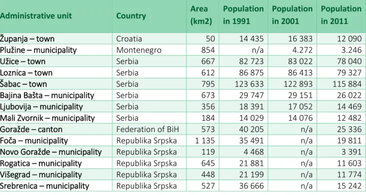
The Drina Euroregion has 17 administrative units among its members, which lie in four different countries, Serbia, Croatia, Montenegro, and Bosnia and Herzegovina (see Table 1). All of them are situated in the basin of the Drina River. The total area of the Euroregion (as the sum of the members’ area) is 7 907 km2, while according to the latest census (from 2011 in Croatia, Serbia and Montenegro, and from 2013 in Bosnia) the total population of the Euroregion counts 628 685 people.
Table 1: Members of the Drina Euroregion, their area and population number
Administrative unit Country Area
(km2)
Population in 1991
Population in 2001
Population in 2011
Županja – town Croatia 50 14 435 16 383 12 090
Plužine – municipality Montenegro 854 n/a 4.272 3.246
Užice – town Serbia 667 82 723 83 022 78 040
Loznica – town Serbia 612 86 875 86 413 79 327
Šabac – town Serbia 795 123 633 122 893 115 884
Bajina Bašta – municipality Serbia 673 29 747 29 151 26 022
Ljubovija – municipality Serbia 356 18 391 17 052 14 469
Mali Zvornik – municipality Serbia 184 14 029 14 076 12 482
Goražde – canton Federation of BiH 573 40 205 n/a 25 336
Foča – municipality Republika Srpska 1 135 35 491 n/a 19 811
Novo Goražde – municipality Republika Srpska 119 4 468 n/a 3 391 Rogatica – municipality Republika Srpska 645 21 881 n/a 11 603 Višegrad – municipality Republika Srpska 448 21 199 n/a 11 774 Srebrenica – municipality Republika Srpska 527 36 666 n/a 15 242
20 The description is based on the work: Strategies and euroregions for cross-border co-operation in Balkan and Danube European countries. (2011) Institute of International Sociology of Gorizia (ISIG) http://isig.it/wp- content/uploads/2012/11/SWOT-Strategies-and-Euroregions-for-CBC.pdf (Downloaded: 28.12.2014) pp. 214- 222.
Administrative unit Country Area (km2)
Population in 1991
Population in 2001
Population in 2011 Bratunac – municipality Republika Srpska 293 33 619 n/a 21 619 Zvornik – municipality Republika Srpska 376 67 795 n/a 63 686 Bijeljina – municipality Republika Srpska 734 96 988 n/a 114 663
Note: The are no census data for Bosnia and Herzegovina from the beginning of 2000s, only from 1991 and from 2013. Source of data: official statistics of the countries
Features of the terrain:
Situated in the south-eastern part of Europe, the area of the Drina Euroregion consists of three highly diverse geographic parts: the northern part is a plain area along the rivers Sava and Drina;
the central part of the area is a hilly landscape, while the southern part is mountainous.
The northern part of the region is covered by lowlands in the basin of the Sava River, with fertile agricultural lands and low hills.
To the south the altitude above sea level increases and the area becomes a hilly landscape with low hills, valleys and ravines, ranging from about 200-350 metres to 350-600 metres. The upper regions in Bosnia are located below the eastern slopes of Jahorina at an altitude between 335- 1 300 meters.
Further south the terrain becomes rather mountainous in the region of Divčibare, Golija, Zlatar, and the Tara Mountains, which are potential areas for economic development due to the presence of natural resources and expanding opportunities for tourism.
On the northern Bosnian side are lowlands (300 metres above sea level) with the basins of the Sava and Drina rivers, with the valleys of the rivers Tolisa, Tinja, Brka, Gnjica and Janja, offering the most favourable conditions for agricultural production. This is the most important Bosnian area for grain production.
In a morphological sense, the southern part of the Euroregion, in Montenegro and Bosnia and Herzegovina, has a diverse relief with high mountains and canyons, deep valleys and river fields.
The terrain is mostly mountainous including some of the most rugged landscapes in Europe.
The average altitude is above 2 000 meters.
The most of the municipalities are located in the middle, hilly part of the Euroregion with an average height above sea level between 300 and 700 meters. This part is very rich in various minerals and hydro-electric potential as important resources for industrial production. Due to the configuration of the terrain the most of the arable land in this area is on slopes, subject to erosion, impeding the use of agricultural mechanisation. This land is climatically and physically more suitable for fruit growing and pasture.
Climate:
The climate in the Euroregion is continental, defined by hot, dry summers and autumns as well as cold winters with heavy snowfall due to the presence of the mountains.
In the north of the Euroregion, in the Sava River Valley there is a temperate continental climate.
Due to the openness of the Pannonian Plain, its lowland parts in the north are under the influence of the Pannonian continental climate, while the hilly mountainous regions to the south at 700 meters above sea level are under the influence of the mountainous climate.
Precipitation is a very important climatic element. Apart of the air temperature, it is of great importance for the survival of flora. The quantity and the annual and territorial distribution of precipitation are different. The amount of rainfall increases from the northeast to the south and southwest. The middle part of the Euroregion is characterised by significant rainfall, rains are frequent, as well as floods. Around Užice the climate is mostly mountainous in the higher and moderate-continental in the lower regions.
On the south the climate varies, but in general it is characterised by the continental climate, with cold winters and hot, humid summers together with well distributed rainfall patterns and heavy inland snowfall. The mean annual temperature ranges between 2 and 8°C. Going towards the valleys of the Piva, Tara, and Komarnica rivers the temperature increases, and the average temperature reaches about 8°C in the valleys of these rivers.
Climatic conditions along the Drina River are defined by its north–south direction with decreasing altitude from high through medium to low, from the mountains towards the Pannonian Plain. The source and the highest area of the basin are influenced by the Mediterranean climate. Its influence gets weaker in the upper part of the basin, towards Foča, where tempered continental climate becomes more prevalent. Finally, in the lower basin of the Drina River, downstream from Zvornik, the climate passes into continental.
The precipitation amounts decrease with the flow, but not proportionally. High mountain regions of the basin over 2 000 meter above sea level receive 2 000-3 000 mm atmospheric precipitation annualy. In the moderately mountainous middle region, the precipitation varies from about 1 400 mm in Foča to 890 mm in Ljubovija, while around the mouth of the Drina it is only 700 mm. Considered as a whole, the basin of the Drina River on average receives 1 030 mm of rainfall a year, based on which it is rich in water. Therefore, the Drina and its larger tributaries (Tara, Piva, Lim) possess large flow rates.
Hydrography:
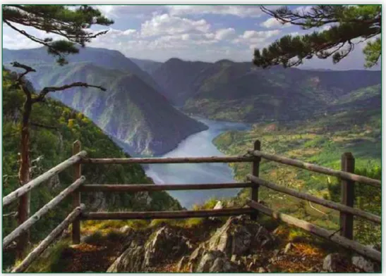
The Drina River, with several high dams, forms 185,3 km of the border between Serbia and Bosnia and Herzegovina. It joins the Sava River in the north. Both rivers are rich in natural resources, various species of fish, and other fauna. This area involves the Tara National Park and Lake Perućac.
The rivers in the south of the Euroregion flow in the mountains along deep canyons such as the Tara River Canyon, which is the deepest canyon in Montenegro and in Europe with 78 km in length and 1 300 meters at its deepest point. There are around fourty natural and seven artificial lakes in the area. This region is rich in water and forests that cover 32% of the territory of the border region.
The hydropower potential of the Drina River and its tributaries has long been recognised. Great water resources, uniform annual and perennial flow, a significant decline in the longitudinal river profiles and canyon – gorge structure of some river valleys make the Drina suitable for building powerful concrete dams, to form artificial lakes. In addition to those already built, there are some projects for constructing new ones. Regarding its hydropower potential the Drina has no equal in the Balkans, but at the same time its hydropower is the least utilised. The economically exploitable water power of the river is estimated at 14,4 billion kWh, while there has been used less than 5 billion kWh so far, which is about 35%. From the possible 40, only nine large hydropower plants have been built on the Drina, Piva, Lim and Uvac rivers.
Nature:
The Drina and its tributaries are rich in fish. In its upper course it has the characteristics of a mountain river, while downstream from Loznica the Drina is a lowland river. Therefore it has various types of fishes typical either to mountain or to lowland rivers. In its upper flow there are species like salmon, trout, barbel, nase, gudgeon, chub, and grayling. Downstream from Višegrad one can find pike, catfish, burbot, and roach. In its lower course, there is bream, tench, crucian carp etc.
There are thick forests along the Drina River and its tributaries in the Tara, Zlatibor, Jahorina and Zelengora Mountains. The southern mountainous area in both countries is characterised by a very well preserved natural environment offering natural resources and biodiversity, suggesting a high potential for the development of agriculture, power generation, and tourism.
Population:
Ethnicity has played an important role in the recent history of the region and is reflected in the current profile of the Euroregion. In the 1990s extensive migrations of inhabitants took place between these countries on all sides of the borders. As a result, today’s demographic picture in the border areas is significantly different from the one before the war. These changes seem irreversible given the slow and difficult return of refugees. Most of the population decline is visible in the rural areas along the borders.
The biggest minority group in Croatia is the Serbian minority. Relations between Croats and Serbs have been tense and difficult during the nineties, but the situation has somewhat improved since the beginning of the new century. The ethnic structure in BiH is complex. BiH
consists of three constituent nations: Bosniaks, Serbs and Croats. Relations of those constituent nations have been, and continue to be a main challenge for the stability and development of the country. The biggest national minority in BiH is the Roma minority. In Serbia the ethnic majority of the Euroregion’s population is Serbian, while the largest ethnic group is that of the Bosniaks.
Today, all inhabitants in the Euroregion enjoy full equality in each country, ensured by the constitutions of the countries strongly guaranteeing minority rights.
Economy:
Thanks to the fertile soil in the valley basin, the main economic resource in the north of the Euroregion is good quality land suitable for all types of agricultural production. There are landscapes of intensive agriculture with the production of cereals and vegetable crops, as well as fruits. Bijeljina (BiH), Županja (Croatia) and Šabac (Serbia) are large centres for production and trade of food. The rivers Sava and Drina contribute to the development of many branches of industry – metal industry, water management, agriculture, river transport, and tourism.
Therefore the key industrial activities within the Euroregion are food-processing, wood- processing and furniture manufacturing, chemical and light metal industry, and textile industry.
The western and southern parts of the region are favorable for tourism in the summer (canyons of Piva, Sutjeska, Tara and Zlatibor mountains) and winter (Jahorina, etc.). The surrounding countryside, the environment and the abundant natural beauty make good preconditions for the development of mountain sports and recreation, religious, rural and hunting tourism.
Transport:
The region has a connection with the Belgrade–Zagreb motorway in its northern part.
Forthermore, a section of the Belgrade–Podgorica main road is passing through it in the east, while the Foča–Goražde–Višegrad–Užice road and the Nikšić–Plužine–Foča–Sarajevo route also cross the area of the Euroregion.
The above indicates that the entire region has a connection only with the E-70 international road in the north, while in all other directions it is far away from all the important European corridors. No highway passes through this area. The largest part of the road network consists of class 1 roads and local, class 2 roads.
Concerning the railroads, the Belgrade–Bar railway line passes through Užice, however it is in a very bad condition. Practically, all other forms of transport within the Euroregion, so railway, air and water transport are at a negligible level.
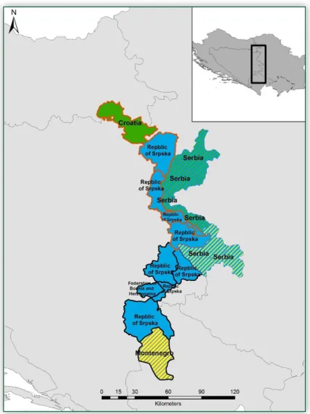
3.7 Administrative units – members
As it is shown in Table 1, there are seventeen members of the Drina Euroregion, which represent different levels of self-government, from municipality through town to canton level.
Figure 4 presents and the text below describes these administrative units.
Figure 4: The administrative structure of the Drina Euroregion Source: RTT’s own construction
Županja (Croatia)
Županja is located in Slavonia, Eastern Croatia. The town, which in 2011 counted 12 090 inhabitants (in 1991 14 435 and in 2001 16 383), lies in an area of 50 km2 along the Sava River and it is the centre of the Županja Microregion. The majority of its population is Croat (96,72%), but there are also Serbs, Bosniaks, Albanians, Hungarians, and others nationalities.
This town is an important junction of major road routes in east-west and north-south directions. The Belgrade–Zagreb motorway passes next to Županja, which is the main connection between Bosnia and other parts of Europe.
Concerning industrial production, there are food processing companies, a factory of agricultural machines and a wood processing firm. The surrounding forests are rich in many kinds of wildlife, and the waters of Županja region offer a rich fishery potential. During the year there are traditional cultural events such as harvest feast and actors' festival, and the town is known for its gastronomy as well.
Bijeljina (Republika Srpska)
The town of Bijeljina is the centre of the municipality located in the northeastern part of Republika Srpska in Bosnia, at the confluence of the Sava and the Drina. These two rivers represent the border with Croatia in the north and Serbia across the Drina. The town has an attractive geo-strategic position: it lies along the borders of Serbia, Croatia and Republika Srpska; here are the crossroads of the major urban and industrial centers – Belgrade, Novi Sad, Banja Luka, Šabac, Tuzla, and Sarajevo; moreover, it is at the edge of the Pannonian Plain and the Balkan Peninsula.
Bijeljina municipality covers an area of 734 km². The estimated number of inhabitants in the municipality of Bijeljina, according to the 2013 census is 114 663 (in 1991 it was 96 988). This is the second most populous municipality in Republika Srpska, right after Banja Luka.
Thanks to the fertile soil, Bijeljina is one of the centres for the production and trade of food, mostly cereals and vegetable crops. It lies on a vast underground lake of thermal water used for spa treatment in the famous Banja Dvorovi, six kilometers from the town of Bijeljina. The municipality has become an attractive tourist destination visited by more and more domestic and foreign tourists.
Zvornik (Republika Srpska)
The territory of the municipality of Zvornik covers an area of 376 km2, and it is located in northeastern Bosnia. Zvornik lies on the eastern slopes of Majevica at an altitude of 146 m. The town has a favorable geographical position and is located in the middle of the road towards three major urban centers: Belgrade, Novi Sad, and Sarajevo. The municipality of Zvornik has 63 686 inhabitants according to the 2013 census (67 795 in 1991).
The municipality has 61 settlements. The Drina River with its tributaries provides a significant hydroelectric potential. Zvornik is one of the nine most developed municipalities of the Republika Srpska. It is rightly considered as an urban, commercial, communications, industrial, medical, educational, sports, cultural and tourist centre of the wider region. For its great strategic importance Zvornik is considered for the „key to Bosnia“.
The Drina River and the Lake Zvornik are rich in trout and suitable for fishing, water sports and vacation, which presents a solid base for the development of tourism.
Bratunac (Republika Srpska)
The territory of the municipality of Bratunac is located in the eastern part of Bosnia and Herzegovina, as part of the Republika Srpska, and it covers an area of over 293 km2 with 21 619 inhabitants (2013 census, 33 619 in 1991). The Drina River forms the border with Serbia (municipalities of Ljubovija and Bajina Bašta). The town itself is situated 3 km from the border with Serbia, 140 km from Sarajevo, and 210 km from Belgrade. The municipality covers a large lowland belt on the left bank of the Drina River.
The economic activity in the municipality takes place within shops, construction, industrial and transport companies and two farms.
The rapid flow of the Drina River offers possibility of drifting, and the municipality of Bratunac used it in promoting its tourism potential. The development of agriculture can be based on favourable climate, altitude, hydropotential and traditions.
Srebrenica (Republika Srpska)
The municipality of Srebrenica lies in the eastern part of Bosnia and Herzegovina, in the Republika Srpska. It is a small mountain town of 527 km2. The current population counts 15 242 people (according to 2013 census). However, before the war in Bosnia Srebrenica had 36 666 inhabitants (1991 census), with an ethnic structure of about 75% Muslims (about 27 500 people), 22,7% Serbs (about 8 300 people) and 2,3% other nationalities at that time. The current composition of the population is quite different. Based on the preliminary results of the census from 2013, the share of Muslims fell to 44,8% (about 7 000 people), while the share of Serbs has more than doubled to 54,5% with slight rise in absolute numbers (about 8 500 people).
Under the 1995 Dayton Agreement that ended the Bosnian War, Srebrenica was included in the territory assigned to Bosnian Serb control as part of the Republika Srpska entity of Bosnia and Herzegovina. Although guaranteed under the provisions of the Dayton Agreement, the return of survivors was repeatedly obstructed. In 2007, verbal and physical attacks on returning refugees continued to be reported in the region around Srebrenica.
Before 1992, there was a metal factory in the town, as well as lead, zinc, and gold mines nearby.
The town's name (Srebrenica) means "silver mine", the same meaning as its old Latin name Argentaria. Before the war, Srebrenica also had a big spa and the town prospered from tourism and salt mining, too.
Višegrad (Republika Srpska)
The municipality of Višegrad is located in the east of the Republika Srpska and Bosnia and Herzegovina, 16 km from the border with Serbia. The municipality with its 448 km² is among the smaller ones in Bosnia, with 11 774 inhabitants according to the last census of 2013 (21 199 in 1991).
Until 1970, the narrow gauge railway Belgrade–Sarajevo passed through Višegrad. Today a part of it is renewed for tourism purposes, the famous Šargan Eight between Mokra Gora and Kremani in Serbia, and the reconstruction works on the railway line from Mokra Gora to Višegrad are in progress. The Drina River also provides great opportunities for tourism development.
Until the war Višegrad had a dynamic socio-economic development with an extremely developed metal, chemical, textile and wood processing industry. Today there is a hydropower plant, a company for producing steel ropes, a textile firm, a rehabilitation centre, and a commercial company. Three hydropower stations have been built on the Drina River so far, which has turned a greater part of its course into a quiet lake surface.
Rogatica (Republika Srpska)
Rogatica spreads in the mid-eastern part of the Republika Srpska, Bosnia and Herzegovina. It covers an area of 645 km2 with a population of 11 603 inhabitants according to the preliminary results of the 2013 census (almost half than twenty years ago; 21 881 in 1991).
Rogatica is an area of outstanding natural beauty, with clear mountain rivers, dense deciduous and coniferous forests, blossoming pastures and meadows, rich cultural and historical heritage, clean air and healthy homemade food.
Widely famous Borike are a paradise for those who want to enjoy nature walks, collecting medicinal herbs, berries and mushrooms; or to engage in hunting, biking or horseback riding.
Novo Goražde (Republika Srpska)
The municipality of Novo Goražde, previously called Srpsko Goražde, was established with the division of the prewar municipality of Goražde in 1994, and verified after the Dayton Peace Agreement in 1995. It is bordered by Goražde, Čajniče, Rogatica, Višegrad and Foča.
Novo Goražde is a place where many important roads and rivers cross, civilisations meet, nations, religions and customs get mixed. The municipality covers 119 km2, the population after the 2013 census was 3 391. It is located in the heart of Upper Drina Region and below the eastern slopes of Mount Jahorina.
Within its industrial zone there is a wire factory, machine works, a refrigerator factory, and several private firms and small private companies.
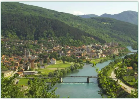
Foča (Republika Srpska)
The municipality of Foča is a spatial unit occupying an area of 1 135 km², along the upper part of the basin of the Drina River. Located in the southeastern part of Bosnia, respectively the Republika Srpska, the eastern and southern boundaries of the municipality are also the borders with Montenegro, while in the north it borders with the Federation of BiH. Foča has a favorable geographical position, at the intersection of the roads towards Sarajevo and Nikšić.
Foča had 19 811 inhabitants at the last census in 2013, so the number of people has almost halved in the last two decades (in 1991 there were 35 491 inhabitants).
This area includes the Sutjeska National Park with the Perućica forest, the Zelengora and Maglić Mountains; the deepest canyon in Europe, the Tara River Canyon shared by this municipality and its Montenegrin neighbours, a number of lakes teeming with fish, as well as important natural reserves. All these attractions are awaiting lovers of unspoilt nature.
Many streams are crossing this area, which is thus rich in water. Therefore it would only be necessary to introduce certain technical procedures in order to ensure the benefit of the wider community.
Bosansko-podrinjski kanton Goražde (Federation BiH)
Goražde is the smallest canton in the Federation of Bosnia and Herzegovina. It covers an area of 573 km² and has a very favorable geographic position, extending to the eastern slopes of Jahorina, Borovac and Klek.
Within the canton there are the municipalities of Goražde, Foča-Ustikolina and Pale-Prača. The current population of the whole canton is 25 336 (2013), while the same area had 40 205 inhabitants in 1991. Goražde is the administrative, political, educational, and cultural centre of the canton.
This canton has always been a link between the East and West. It is bordering with Serbia and Montenegro, and the routes to Dubrovnik in Croatia as well as to central Bosnia are passing through it. Goražde is rich in natural beauty. There are excellent conditions for tourism development, especially rural, but also adventure tourism, attractive to people who like untouched nature and camping.
Šabac (Serbia)
The town of Šabac lies in the northern part of western Serbia and represents the economic and cultural centre of Podrinje and the wider area. The geographical position of the municipality is very convenient because it is located on important traffic routes, passing towards Belgrade, Novi Sad, Loznica, Valjevo and Bijeljina.
The municipality of Šabac covers an area of 795 km2 and has 115 884 inhabitants (in 2011, 123 633 in 1991, and 122 893 in 2002). The town itself has 52 822 inhabitants according to the census of 2011 (53 919 in 2002), with about 70 000 people living in its suburbs.
The basic economic potentials are in high quality land suitable for all types of agricultural production and the water of the rivers Sava and Drina suitable for the development of many branches of industry, water management, agriculture, river transport, and tourism.
The dominant industries in the town are chemical, pharmaceutical, metal, mechanical, food and construction material industry. There are nearly 4 200 companies (about 2 800 entrepreneurs) operating in Šabac.
Loznica (Serbia)
Loznica is located at the foot of the northern slopes of the Gučevo Mountain, at an altitude of 142 m. The municipality of Loznica extends to 612 km2, lying between the Cer Mountain, the southern parts of Mačva, the Drina River to the west, and Gučevo and Boranja Mountains to the south. According to the 2011 census it has 79 327 inhabitants (86 875 in 1991 and 86 413 in 2002), while in the town of Loznica there are 18 714 people.
Loznica has a good geographic and traffic position. The main roads Belgrade–Šabac–Loznica–
Zvornik–Tuzla–Sarajevo, and Bijeljina–Loznica–Mali Zvornik–Bajina Bašta–Užice and further to the Montenegrin coast are passing through Loznica. The road through Loznica–Osečina–
Valjevo–Lajkovac connects to the Ibar highway. The Šabac–Zvornik railroad is also passing through Loznica.
Loznica is the natural, economic, transport and cultural centre of this part of Podrinje.
Ljubovija (Serbia)
Ljubovija is a municipality located on the road Šabac–Bajina Bašta. It is a mountainous area in western Serbia along the border with the Republika Srpska, Bosnia and Herzegovina.
Ljubovija covers an area of 356 km2 and has 14 469 inhabitants according to the 2011 census (formerly 18 391 in 1991 and 17 052 in 2002). The municipality consists of the settlement of Ljubovija with 3 946 inhabitants, and another 27, mostly smaller villages.
Agricultural land in the municipality of Ljubovija occupies 57,5% of its surface, and beside mining and industry agricultural production is the largest source of income.
From the branches of industry, there is mining, metal processing as well as chemical, building materials, food and tobacco industry in Ljubivoja. Despite its relatively satisfactory growth rates, the degree of industrialisation of the area is below the level of similar municipalities in Serbia.
Ljubovija with its environment is involved in the tourism offers of Serbia. The surrounding villages of Azbukovica are abundant in natural beauty and conditions for the development of mountain sports and recreational, religious, rural and hunting tourism. The Drina Regatta in Ljubovija has a tradition of almost a decade.
Mali Zvornik (Serbia)
The municipality of Mali Zvornik is located in the western part of Serbia, in the Middle Drina Valley. The western boundary of the municipality to Bosnia and Herzegovina and the Republika Srpska is the Drina River. On the opposite bank of the river, there is the Bosnian municipality of Zvornik.
The area of the municipality is 184 km², which is the smallest one in Mačvanski District and one of the smallest municipalities in Serbia. The total population according to the census of 2011 is 12 482 (it was 14 029 in 1991 and 14 076 in 2002). The settlement Mali Zvornik itself has 4 384 inhabitants, while the whole municipality has 11 local governments on its territory.
The only economic organization is the hydropower plant Zvornik, employing 80 workers and producing more than 22 billion KWh of electricity.
Mali Zvornik, which is outstanding primarily in the preserved nature of the surrounding mountain landscape and water resources of the Drina River, provides ideal conditions for rural tourism and tourism with special interests, primarily fishing and hunting.
Bajina Bašta (Serbia)
Bajina Bašta is a town in western Serbia, on the right bank of the Drina River, below the Tara Mountains. The whole municipality, lying on 673 km2 has 26 022 inhabitants according to 2011 census (29 747 in 1991, 29 151 in 2002). The town itself has 9 323 inhabitants.
The once peripheral and quite closed region in Serbia has gradually become an important centre of forestry, energy industry, and tourism. Hydropower plants with artificial lakes on the Drina and the Tara river have supplemented and embellished the tourist card of Račanski district. Tara is a national park with an area of 19 200 hectares and covers the largest part of this mountain.
Užice (Serbia)
The town of Užice is the seat of the Zlatibor District, located on the banks of the Đetinja River in Serbia. Its area is 667 km2. The highway to the Adriatic coast and the railway between Belgrade, Serbia and Bar, Montenegro pass through Užice. There is the state border with Bosnia and Herzegovina in Mokra Gora and the Ponikve airfield is qualified for civilian air traffic.
According to the census of 2011 the whole municipality had a population of 78 040 (82 723 in 1991 and 83 022 in 2002) and the town itself has 52 199 inhabitants (54 717 in 2002).
The town is a centre of metal and machine industry and fruit-growing. Užice, as the economic centre of western Serbia, is one of the few cities in Serbia with a surplus in foreign trade. This fact confirms that the economy of Užice is healthy, competitive and export-oriented.
Companies from the manufacturing and coloured metal industry, construction, trade, textile and wood industry and other branches of tertiary activity have the greatest impact on the local economy.
The potentials of the rivers Drina, Lim, Uvac, and Đetinja are used to raise five hydroelectric power plants. Zlatibor and Tara are the leading centres of mountain tourism, while Zlatar, Golija and Javor mountains are also popular.
Plužine (Montenegro)
The municipality of Plužine is located in northern Montenegro and covers an area of 854 km².
This is an extremely high land, with peaks over 2 300 m. It is a historical territory since it has been one of the most important desinations of migration; it took namely quite a long time for the population to descend from the high mountains to relatively lower lands. Currently the municipality has 3 246 inhabitants, while a decade ago there were a thousand more people living in these settlements.
In the municipality of Plužine there is no industry that could undermine the purity of air, while the meteorological conditions are favorable for the dispersion and diffusion of polluants.
Although most of the inhabitants of Plužine live from agriculture and animal husbandry, this area has great potentials for tourism development. Huge canyons of the Tara, Piva, Komarnica, and Sušica, Piva Lake, alpine massifs with transparent lakes, idyllic villages in the Piva Mountains could be ideal scenes for adventure and holiday. Unfortunately, most of this natural wealth is not valued in the right way.
In the municipality of Plužine there are some industrial, forestry, agricultural and commercial enterprises, with a high proportion of micro-enterprises making up 71% of all businesses.
4. Organisational and institutional structure, operation
The bodies of the Drina Euroregion are:
1. Assembly 2. President 3. Executive Board 4. Supervisory Board
Assembly
The Assembly is the representative and the highest body of the Drina Euroregion. The Assembly is formed by the legal representatives of the member territorial self-governments. Each member’s representative is entitled to one vote in the Drina Euroregion. Each member appoints one representative and his/her deputy.
The Assembly of the Drina Euroregion decides on the number of representatives and its structure. The status of the representative of a member in the Euroregion is acquired by submitting a written decision on the appointment, issued by an authorised body of the respective member.
Concerning its scope of work and competence, the Assembly of the Euroregion:
a) Passes the amendments to the Statute of the Drina Euroregion, the internal rules of procedure, the annual program of the Euroregion, the financial plan and annual financial statements, decisions on admitting new members and awarding the observer or contributing institutions status, the decision on the award of public recognition of the Euroregion, as well as any other activities that the Statute has not explicitly delegated to other bodies;
b) Selects the President and Vice-President of the Drina Euroregion, as well as its Supervisory Board, the members of the commissions and the members of the Executive Board;
c) Considers the realisation of program activities and other acts of the Euroregion, the reports on the work of the Euroregion’s bodies, and other issues of importance to the operation of the Euroregion;
d) States the basic elements of the policies of the Euroregion contained in its programs, and the methods of ensuring, distributing and using the resources available to the Drina Euroregion for achieving its objectives.
The Assembly holds regular sessions at least once a year, as a rule every time in another member state. The Assembly sessions are convened by the President of the Drina Euroregion on his/her own initiative, by a reasoned decision of the Executive Board or the Supervisory
Board, or if the majority of the members require it. The Assembly can elect a working presidency and entrust it to conduct the session. The Assembly generally makes decisions by unanimous vote of the members present, except in cases when the Statute and the Rules of Procedure prescribe a different majority.
President
The Drina Euroregion has a president and a vice-president. They are elected by the Assembly for a two-year mandate with the possibility of re-election, so that the president and the vice- president are from different countries.
The President convenes and presides over the meetings of the Assembly and the Executive Board, signs their acts, adjusts the work of the bodies, presents and represents the Euroregion, and performs other duties provided for in the Statute.
Executive Board
The Executive Board is the executive body of the Drina Euroregion and it has 17 members. The Executive Board is elected by the Assembly for a term of two years, in accordance with the provisions of the Rules of Procedure. Of these 17 members, the president of the Drina Euroregion and the vice-president are ex officio members of the Executive Board.
The Executive Board is accountable to the Assembly within the limits of the powers and duties entrusted to them. The Executive Committee or any of its members can be revoked if they do not meet the obligations laid down in the Statute, or act contrary to the provisions of the Statute and the guidelines established by the Assembly.
The duties of the Executive Board are that it ensures the implementation of the Statute, other acts and guidelines established by the Assembly; performs financial plan, cares about the proper use of funds and making of implementation decisions; organises and coordinates cooperation with other organisations; follows the work of commissions and considers their proposals; regulates and organises publishing and information activities of the Drina Euroregion; appoints the secretary of the Executive Board; determines the organisation to perform professional duties of the Euroregion and adopts the respective acts; and performs tasks entrusted to it by the Assembly necessary for the normal functioning of the Drina Euroregion, using already existing structures that work in the field of cross-border cooperation.
The Executive Board meets regularly at least once every six months, each time in another member state. The decisions of the Executive Board are valid if the majority of its members support them. The Executive Board shall be convened by the President of the Drina Euroregion at its discretion, at the request of one third of the members of the Executive Board or by the Supervisory Board.