Full Terms & Conditions of access and use can be found at
https://www.tandfonline.com/action/journalInformation?journalCode=tjom20 ISSN: (Print) 1744-5647 (Online) Journal homepage: https://www.tandfonline.com/loi/tjom20
Loess distribution and related Quaternary sediments in the Carpathian Basin
Frank Lehmkuhl, Janina Bösken, Jan Hošek, Tobias Sprafke, Slobodan B. Marković, Igor Obreht, Ulrich Hambach, Pál Sümegi, Arne Thiemann, Stefanie Steffens, Heiko Lindner, Daniel Veres & Christian Zeeden
To cite this article: Frank Lehmkuhl, Janina Bösken, Jan Hošek, Tobias Sprafke, Slobodan B. Marković, Igor Obreht, Ulrich Hambach, Pál Sümegi, Arne Thiemann, Stefanie Steffens, Heiko Lindner, Daniel Veres & Christian Zeeden (2018) Loess distribution and related Quaternary sediments in the Carpathian Basin, Journal of Maps, 14:2, 661-670, DOI:
10.1080/17445647.2018.1526720
To link to this article: https://doi.org/10.1080/17445647.2018.1526720
© 2018 The Author(s). Published by Informa UK Limited, trading as Taylor & Francis Group on behalf of Journal of Maps
View supplementary material
Published online: 25 Oct 2018. Submit your article to this journal
Article views: 866 View related articles
View Crossmark data Citing articles: 6 View citing articles
Science
Loess distribution and related Quaternary sediments in the Carpathian Basin
Frank Lehmkuhl a, Janina Bösken a, Jan Hošekb, Tobias Sprafke c, Slobodan B. Markovićd, Igor Obrehta,e, Ulrich Hambachf, Pál Sümegig, Arne Thiemann a, Stefanie Steffensa, Heiko Lindnera, Daniel Vereshand Christian Zeeden a,i
aDepartment of Geography, RWTH Aachen University, Aachen, Germany;bCzech Geological Survey, Prague, Czech Republic;cInstitute of Geography, University of Bern, Bern, Switzerland;dLaboratory for Paleoenvironmental Reconstruction, University of Novi Sad, Novi Sad, Serbia;eOrganic Geochemistry Group, MARUM-Center for Marine Environmental Sciences and Department of Geosciences, University of Bremen, Bremen, Germany;fBayCEER & Chair of Geomorphology, University of Bayreuth, Bayreuth, Germany;gDepartment of Geology and Palaeontology, University of Szeged, Hungary;hRomanian Academy, Institute of Speology, Cluj-Napoca, Romania;iIMCCE, Observatoire de Paris, PSL Research University, Paris, France
ABSTRACT
Supraregional (palaeo)geoecological studies require detailed knowledge of the distribution of aeolian sediments and their sources. Such spatial data can be visualised and shared in maps, but often these are constrained in their resolution or extent. This is the case for the Carpathian Basin, where cross-border maps are not detailed enough to answer many research questions. Problems occur especially along political borders due to different geological mapping standards and varying lithological definitions. Using a Geographic Information System (GIS), we compiled a map showing the distribution of loess and related Quaternary sediments in the Carpathian Basin, with unprecedented detail. We vectorised and analysed existing data (mainly from geological maps) and combined and transferred these into a common (loess) sediment classification system. This cross-border map shows the distribution of aeolian sediments in the Carpathian Basin at a scale of 1:1,500,000. For the northwestern and the southern Carpathian Basin, we added maps that clarify the extent of late Pleistocene and Holocene terrace and floodplain deposits, which were merged in the Main Mapto highlight the predominant dust source areas for this region.
ARTICLE HISTORY Received 2 May 2018 Revised 20 August 2018 Accepted 28 August 2018 KEYWORDS
Loess map; aeolian sediments; dust sources;
spatial data; GIS; Pannonian Basin; palaeo-landscapes
1. Introduction
Knowledge about the regional distribution of loess sediments is important for applied purposes in agron- omy (soil fertility, soil erosion potential, hydrogeology) or engineering (building ground, natural hazards).
Fundamental research on supraregional scale palaeoenvironmental and palaeoclimatic evolution requires a more differentiated and at the same time unified database of the distribution of loess sediments and their sources. However, available maps of loess and related sediments in the Carpathian Basin often lack detail or most commonly do not extend across national borders encompassing parts of the basin.
This issue gets further complicated by various regional usage of loess definitions, which is related to the com- plex genesis of loess sediments (Sprafke & Obreht, 2016). This results in difficulties to harmonise loess maps available from different countries or even within the same region.
Different national maps of Quaternary deposits are published (e.g.Gaudenyi & Jovanovic, 2011). Based on discussions and work of the former INQUA Loess Commission, a European loess map was published by
Haase et al. (2007). Recent studies on loess refer mainly to this map, in spite of many methodological limit- ations and inconsistencies. Since different terminologi- cal and methodological foci were used, loess was only arbitrarily mapped as Quaternary deposits in certain areas, e.g. western Romania (Lindner, Lehmkuhl, &
Zeeden, 2017). As such, the European loess map dis- plays several inconsistencies at national borders, such as artificial breaks, displacements and incorrect delimi- tated geological units or sediment types. These artificial breaks highlight the need to simplify geodata sets from different countries or even from different surveys within one country (Witschas, 2005,2007). In a recent approach, Bertran, Liard, Sitzia, and Tissoux (2016) generated a map of Pleistocene aeolian deposits in Western Europe by using the Land Use and Cover Area frame Statistical survey (LUCAS) database for topsoil properties in Europe. This database has a higher degree of international consistency, and was used to extract information on loess distribution and thickness. However, these data cannot discriminate between different silt-dominated deposits on the land surface.
© 2018 The Author(s). Published by Informa UK Limited, trading as Taylor & Francis Group on behalf of Journal of Maps
This is an Open Access article distributed under the terms of the Creative Commons Attribution License (http://creativecommons.org/licenses/by/4.0/), which permits unrestricted use, distribution, and reproduction in any medium, provided the original work is properly cited.
CONTACTFrank Lehmkuhl flehmkuhl@geo.rwth-aachen.de Department of Geography, RWTH Aachen University, Templergraben 55, 52056 Aachen, Germany
JOURNAL OF MAPS 2018, VOL. 14, NO. 2, 661–670
https://doi.org/10.1080/17445647.2018.1526720
To overcome these issues, we compiled a new map of loess and related sediments (aeolian sand / sandy loess, loess derivates) that cover the Carpathian Basin. In addition, the map also highlights the late Pleistocene and Holocene floodplains and terraces of the major rivers without loess cover, in order to indi- cate some of the major source areas for aeolian sedi- ments (Smalley et al., 2009). Our first approach to create a map of late Quaternary sediments and in par- ticular loess sediments relied on geological and geomor- phological maps of the region (Lindner et al., 2017).
Lindner et al. (2017)identified the content and compo- sition of the Romanian geological map (Ovejanu, Can- drea, & Craciunescu, 1968, scale 1:200,000) as problematic for this compilation and included infor- mation from the soil map by Florea, Conea, & Mun- teanu, 1971 for the border region of Hungary and Romania. The work ofLindner et al. (2017)is incorpor- ated into our updated map discussed here.
Despite some remaining limitations, which will be discussed later, our map displays the most detailed overview to date of loess and related sediments and their local sources in the Carpathian Basin, as a basis and stimulation for further research in the area. To facilitate further improvements of this map, the used shapefiles are available online (doi: 10.5880/
SFB806.43).
2. Study area
The Carpathian Basin is an approximately 140,000 km² intra-montane basin in the southeastern part of central Europe (map A and B). The basin is sometimes also referred to as Pannonian Basin, but this term strictly speaking refers to a late Miocene basin formation.
Therefore, we avoid this term here. The Carpathian Basin and surrounding lowlands are characterised by a vast occurrence of aeolian deposits including loess, which have been studied intensively in palaeoclimato- logical and palaeoenvironmental research (e.g. Barta, 2014;Bradák-Hayashi, Biró, Horváth, Végh, & Csillag, 2016;Frechen, Oches, & Kohfeld, 2003;Horváth, 2001;
Novothny, Frechen, Horváth, Wacha, & Rolf, 2011;
Schatz, Qi, Siebel, Wu, & Zöller, 2015;Sümegi, Persaits,
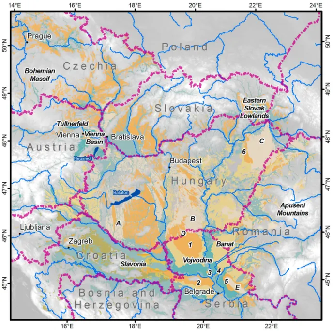
& Gulyás, 2012). Loess is common in this area since at least the mid Quaternary as Pleistocene deposit of the glacial cycles (Bronger, 1976; Horváth & Bradák, 2014;Markovićet al., 2016,2015). The origin of aeolian silts are global dust sources (e.g. Sahara desert, dry shelves) but also glacial grinding of alpine glaciers and the local source from the floodplains of the Danube River and its tributaries. The rivers act also as local source for sandy sediments. Based on the new map, we give a detailed description of the study area with a focus on loess and related sediments.Figure 1gives an overview of the research area including places of interest mentioned in the article.
3. Methods
3.1. Source maps, spatial data and processing The presented map extends the loess distribution map byLindner et al. (2017), which aimed to harmonise the border region of Hungary and Romania. To cover the Carpathian Basin completely, the geological map of former Yugoslavia 1:500,000 (Federal Geological Insti- tute, 1970), the geological map of former Czechoslova- kia 1:200,000 (Fusan, Kodym, Mateijka, & Urbanek, 1960), the geomorphological map of the Autonomous Province of Vojvodina 1:200,000 (Košćal, Menković, Mijatović, & Knežević, 2005), and the geological map of Austria (Vetters, 1933) were used. The Austrian part was complemented with spatial data from the map of Quaternary sediments and landforms provided byFink and Nagl (1979). Finally, a geological map of the eastern part of Croatia (CGS, 2009; in Galović, 2016) and geological maps of Romania (Ovejanu et al., 1968; Săndulescu et al., 1978) were taken into account. For some regions newer or more detailed maps are available (e.g. Fuchs & Grill, 1984), but for the presented purpose it is not feasible to digitise maps with a resolution above 1:200,000.
All maps, except the one byLindner et al. (2017)and the data of theCzech Geological Survey (2017), were only available as paper maps or scans. Paper maps were scanned thoroughly in total with a resolution of 600 dpi, similar to common print resolutions. The digi- tal raster images were georeferenced using coordinate grids (whenever available) as well as characteristic landmarks. The cartographic realisation of the original maps aimed for a high readability by humans but not machines. Therefore, all polygons of interest had to be digitised manually.
The coordinate reference system (CRS) differs between the original maps. For this purpose, the poly- gons were created using the European Terrestrial Reference System (ETRS) 1989 Lamberts Equal Area projection, as recommended by the European Union INSPIRE (2014). A 1-arc-second Japan Aerospace Exploration Agency (JAXA) Advanced Land Observ- ing Satellite (ALOS) averaged digital surface model (DSM) makes up the topographic base map. This glob- ally available elevation model is based on the AW3D- data set, which has a resolution of < 5 m. The high-res- olution data was derived from stereographic multi- temporal satellite imaginaries, which were stacked, mosaicked, and validated with existing height refer- ences. This data set was down-sampled to offer the elevation data free of charge. The resultant DSM has a resolution of ∼ 30 m and a height accuracy of less than 5 m and is downloadable in 1° × 1°-tiles (Tadono et al., 2014, 2016; Takaku, Tadono, & Tsutsui, 2014;
Takaku, Tadono, Tsutsui, & Ichikawa, 2016). These tiles were mosaicked to obtain seamless and accurate elevation data for the study area.
3.2. Generalising and merging of the geodata The definitions of loess and related deposits differ between the national geological nomenclatures. Loess is commonly defined as a deposit of windblown dust, with a specific aggregation related to post-sedimentary processes. Loess-like sediments share this aggregation and a dominance of silt, but are not formed solely from aeolian dust. Loess derivates form from loess and loess-like sediments by further alteration (Sprafke
& Obreht, 2016). In geologic mapping, the determi- nation of loess types is not straightforward, as the gen- esis of yellowish silty deposits is not always well constrained. This is specifically the case when deposi- tional processes (e.g. aeolian,fluvial, slope wash, collu- vial/solifluction) interact. Many mapped loess deposits may be in fact loess-like sediments with a more
complex genesis. However, since it is challenging to distinguish between loess-like sediments and loess derivates, we grouped both as‘loess derivates’, in par- ticular because loess-like sediments are only mapped in Serbia and Croatia. In Hungarian literature, the term
‘infusion loess’ has been used to refer to waterlain silts, which, due to sorting, often exhibit finer grain sizes than typical loess. With loess being an aeolian sediment, the term ‘infusion loess’ is ambiguous.
Nevertheless, these waterlain deposits may incorporate significant amounts of windblown dust fallen into lakes and/or redeposited as overbank deposits. Therefore, we add the classes ‘infusion loess’ and ‘clayey loess’ (where differentiated) to ‘loess derivates’. ‘Sandy loess’ is a transitional deposit to aeolian sand with a bimodal distribution, with peaks in the coarse silt and sand fraction (Koch & Neumeister, 2005).
Figure 1.Overview map of the research area showing places of interest mentioned in the text. Sand regions: A–BelsőSomogy, B– Bács-Kiskun, C–Nyirseg, D - Bačka sands, E - Deliblato sands. Loess regions: 1 -Bačka Loess Plateau, 2 - Srem Loess Plateau, 3 - Titel Loess Plateau, 4 - Tamišloess plateau, 5 - Banat Loess Plateau, 6–Hajdúhát loess.
JOURNAL OF MAPS 663
In order to simplify and synthesise the different maps, several classes were combined.Table 1provides an overview of the digitised maps and their classifi- cations and the classes, which we used for our map.
The final map A contains the following classes: late Pleistocene and Holocenefloodplain, loess, loess deri- vates, aeolian sand & sandy loess, and Quaternary sedi- ments. As the data from the map of Czechoslovakia does not differentiate between loess and loess-loam, we attribute both of them to the class ‘loess’. In the region of the western former Yugoslavia, loess was not differentiated in detail, but one can assume that most of the mapped Quaternary is composed of loess and loess derivates. Therefore, we added this class here as well. Unfortunately, it was not always possible to distinguish the loess and aeolian sands in this map, which is why it cannot be ruled out that some aeolian sands are included in this class of‘Quaternary sediments’. Map B shows the different data sources and the extent of map A, C and D. Different authors and geological surveys were responsible in this area, leading to a varying degree of detail in the mapping of loess and related Quaternary deposits.
To illustrate the spatial relation especially with regard to the river terraces in two distinct regions, we inserted maps C (northwestern region, mainly eastern Austria) and D (southern region, mainly northern Ser- bia), which show the terraces separately. The merging of ‘late Pleistocene and Holocene floodplain and ter- race deposits’ in the Main Mapis achieved in order to visualise the extent of late Pleistocene to early Holo- cene braided river systems, which act as predominant local source areas of aeolian sediments.
For Austria, we combined two maps; the map of Vetters (1933)is more compatible and has the appro- priate scale for our approach, but it lacks the ‘loess derivates’that are located in the southeast of Austria.
From the map ofFink and Nagl (1979), we added the
‘Staublehm’ (= dust loam) to our map, which is a
‘loess derivate’. Also for Slovenia and the western part of Hungary, we included the‘Staublehm’ distri- bution according to Fink and Nagl (1979) as ‘loess derivates’.
The northern margin (Czech, Slovakia, and Ukraine) was derived from the geological map of for- mer Czechoslovakia (Fusan et al., 1960) and from geo- data (1:50,000; Czech Geological Survey, 2017) provided by the Czech Geological Survey. A small part was added based on the Austrian Geological Map (Vetters, 1933).
For Hungary, we used the detailed map of Balogh et al. (1956), as already published in Lindner et al.
(2017). However, we assigned the alluvial and clayey loess to ‘loess derivates’. In addition, a small loess area in the Hajdúhát region (north of Debrecen in northeastern Hungary) was added due to intensive research on loess in the area.
For Romania, the data byLindner et al. (2017)was further complemented by information from the geo- logical map of Romania (Săndulescu et al., 1978). We combined these two datasets to reduce inadequate cross-border delimitations, especially for the Roma- nian-Serbian border region. Figure 2compares these two datasets.
For Serbia, information from the geomorphological map of the Vojvodina (Košćal et al., 2005) and the
Table 1.List of used source maps and their classifications for late Quaternary sediments. The left column indicates the classifications used in thefinal map. The asterix indicates that it was difficult to distinguish between different units. Therefore, it is possible that also aeolian sands were digitised here.
geological map of Yugoslavia (Federal Geological Insti- tute, 1970) were combined. Although division of loess terraces and loess plateaus is well accepted in the litera- ture of all ex-Yugoslavian states, this division was not considered in the geological maps of Yugoslavia, which is most relevant for Serbia. There, so-called loess terraces (mostly covered at the top with loess- like sediments and loess derivates) and loess plateaus (primary loess) are both mapped as loess. In general, higher geomorphological features (besides mountains and sandfields) within the Vojvodina are loess plateaus (primary loess), whereas lower areas are loess terraces.
For the southwestern margin (Croatia, Slovenia, and Bosnia and Herzegovina), we digitised the geological map of former Yugoslavia, where we also added a gen- eral class of‘Quaternary sediments’to supplement the other (loess) categories. Additionally, a map presented byGalović(2016)was digitised for eastern Croatia. For western Croatia and Slovenia we include data from the map ofVetters (1933). For the combination of the differ- ent geodata, the merge-tool in ArcGIS was used. It should be noted that we assume that digitised maps are accurate. Although we applied a certain degree of expert knowledge, we cannot ground-truth our data.
4. Map design
To visualise the spatial extent of loess and related sedi- ments and their sources in the Carpathian Basin, we decided to use a colour key comparable to the one used byHaase et al. (2007). Major rivers and their late Pleistocene and Holocenefloodplains were inserted to show the potential local dust sources. Cities and national borders enable orientation in the study area.
TheMain MapA contains the distribution of aeo- lian sediments and their potential local sources. Map B shows the extent of map A, C and D and provides the data sources. Maps C and D differentiate the late Pleistocene and Holocenefloodplain and terraces depos- its in the northwest and south of the Carpathian Basin.
5. Discussion of the distribution of loess and other related Quaternary sediments in the Carpathian Basin
Our description of loess and related sediments within the Carpathian Basin starts in the upper and western catchment of the Danube (Austria and Slovenia), con- tinues clockwise to the northern margin of the Car- pathian Basin (Czech, Slovakia and Ukraine), followed by the central and eastern parts (Hungary and Romania), and finally the southern areas (Serbia, Croatia, and Bosnia and Herzegovina).
We observe that at this stage of research our map cannot completely overcome problems related to different definitions and mapping strategies in the var- ious countries. For example, sandy loess is only
mapped by the Hungarian geologists and was incor- porated for Romania in map A based on the work of Lindner et al. (2017). In addition, the accuracy of some older maps is not always clear (no survey descrip- tions, limited explanations). Thinner loess covers are not mapped everywhere. However, the presented map shows unprecedented differentiation and spatial resol- ution for a loess map of this scale. The open access to the shapefiles will allow for aflexible use and improve- ment of this map, including perhaps further geoproces- sing or quantitative approaches such as modelling.
5.1. The northwestern margin and beyond:
Austria and Slovenia
The Main Map A covers only eastern Austria and a small part of Slovenia; map C focusses on this particu- lar part of theMain MapA and differentiates the late Pleistocene and Holocene terraces as remnants of the main glacio-fluvial gravel plain of the last glacial cycle, especially in the Tullnerfeld and the Vienna Basin. Together with the area of the (Holocene)flood- plains of the Danube River and its tributaries, these two units comprise the most important last glacial dust sources. As already mentioned, loess-like sediments are common in Lower Austria, but remain to be differ- entiated from loess in geological maps (Sprafke, 2016).
In Upper Austria and Styria / Burgenland, loess often shows features related to postsedimentary alteration due to moister palaeoclimate, e.g. decalcification and hydromorphism, resulting in the differentiation of Braunlöss (brown loess) or Staublehm (dust loam), respectively (Fink, 1956; Fink & Nagl, 1979), which are both loess derivates. Especially the loess derivates in southeast Austria (mainly dust loam) were to a large extent not included in the map of Vetters (1933), but have been included in map A discussed here.
The mapped sediment cover in Austria comprises loess: 1210 km², loess derivates: 778 km², aeolian sand and sandy loess: 137 km², floodplain: 3820 km² and in addition (see map C) the lower terrace (as part offloodplain in theMain Map): 11,420 km². For Slovenia, the numbers are as follows: loess: 4 km², loess derivates: 1594 km², aeolian sand and sandy loess: 145 km²,floodplain: 829 km², Quaternary sedi- ments: 145 km².
5.2. The northern margin: Czech, Slovakia and part of western Ukraine
Loess in Czechia covers mainly lowland river basins in Moravia. Because the original map by Fusan et al.
(1960) does not differentiate loess derivates from loess, we cannot delimit precisely the extent of these two classes in our map and thus both are referred to as loess. Loess is mostly preserved on Pleistocene river terraces (Hošek et al., 2015, 2017; Zeman et al.,
JOURNAL OF MAPS 665
1986;Zeman, Havlíček, Minaříková, Růžička, & Fejfar, 1980); in general, the thickness of loess increases towards the Bohemian Massif foothills in the west. In some areas, it can reach up to 50 m. In contrast to Cen- tral and Southern Moravia, in the northern regions, only Upper Pleistocene loess is preserved and its thick- ness usually does not exceed 10 m. Along a south–
north transect through the Moravian valley, a progress- ive trend to increasing decalcification of loess is visible.
The mapped loess deposits cover an area of 3616 km².
Aeolian sand and sandy loess represent a rather small cover of 366 km². Floodplain and lower river terraces cover an area of 2029 km².
Loess occupies an area of 6214 km2in Slovakia. The principal accumulation areas are close to the Danube and in the lowlands in the south. The loess thickness can reach up to 40 m (Šajgalík & Modlitba, 1983). In general, the loess thickness continuously decreases towards north and east (Vaškovský, 1977).
Within the Eastern Slovak Lowland, as well as in the high-elevated areas of the central and northern parts of the Western Carpathians, loess is mostly decalcified,
coarser and polygenetic and palaeosols tend to be strongly (pseudo)gleyed (Košťálik, 1989; Šajgalík & Modlitba, 1983;Vaškovský, 1977). Nevertheless, most of these sedi- ments are mapped as loess. In our map, we calculated 1221 km² of aeolian sand and sandy loess and 9285 km² of late Pleistocene and Holocenefloodplain.
Similar sedimentological and palaeopedological fea- tures apply also to the loess cover of the neighbouring Ukrainian territory. Loess and loess derivates cover here the foothills along the lowlands of the Carpathian Basin (Began et al., 1964). In our map we calculated an area of 370 km² of loess and loess derivates in this part of Ukraine. Late Pleistocene and Holocenefloodplain deposits comprise 1246 km².
5.3. The central and eastern part: Hungary and Romania
In Hungary, aeolian sediments are classified and mapped in detail (cf.Balogh et al., 1956; Gaudenyi &
Jovanovic, 2011; Horváth & Bradák, 2014; Lindner et al., 2017). Loess is mainly distributed in western Figure 2.Detail from the border region of Hungary, Serbia and Romania showing the different mapping results especially for Roma- nia. For the legend of Hungary and Serbia, see map B. Thefloodplain shown in Map B is derived fromFlorea et al. (1971).
Hungary, principally south of Lake Balaton, while the loess derivates including clayey loess and so-called infusion loess (see Pécsi, 1973) are found along the Tisza River.
Wind-blown sands are widely distributed. The lar- gest and thickest accumulation lies in the middle of the basin between the rivers Danube and Tisza, down- wind of a fan-shaped valley system (Sebe et al., 2011).
Mapped loess and loess derivates cover areas of 13,918 km² and 14,241 km², respectively. Aeolian sand and sandy loess add up to 21,725 km². Late Pleis- tocene and Holocenefloodplain deposits are mapped in an area of 18,983 km².
In the Romanian part of the Carpathian Basin, loess and sandy loess are mainly distributed in the Banat.
Loess and its derivates also occur subordinately on sev- eral piedmont plains and valley terraces of the Banat Hills and the Apuseni Mountains. Although these geo- data are derived from soil maps and morphometric data, literature references confirm this evaluation (e.g.
Kels et al., 2014). In western Romania only 2168 km² are mapped as loess and 6978 km² as loess derivates.
Aeolian sand and sandy loess add up to 3899 km² and late Pleistocene and Holocenefloodplain deposits comprise 5633 km².
5.4. The southeastern part: Serbia
Loess in Serbia is mostly confined to the northern part of the country. Thick loess deposits are found in the Vojvodina province north of Belgrade. Further geo- morphic features are two sandfields, the Bačka Sands located in the north of the Vojvodina (close to Subo- tica, wind direction from the north and continuation of a sand area from Hungary) and the Deliblato Sands in the southeast of the Vojvodina (wind direc- tion from the southeast; see Gavrilov et al., 2018). In higher elevation,five loess plateaus are developed (see Figure 1 for further details). The flat lowlands of the Vojvodina are made up of river terraces and flood- plains and are the lowest and youngest geomorphologi- cal features in the province. Younger loess derivates cover the terraces (see map D). As this part acts as fluvial gravel plain of the last glacial cycle, this class was added to thefloodplain in map A. Studies on the genesis of widespread silt covers in the lowlands are scarce. The spatial accumulation south of the Sava and Danube Rivers has a patchy distribution (Basarin et al., 2011;Bösken et al., 2017; Obreht et al., 2016).
Mapped loess deposits in Serbia cover an area of 6464 km² and loess derivates comprise 11,101 km².
Aeolian sand and sandy loess and late Pleistocene and Holocene floodplains cover 1020 km² and 11,177 km², respectively. Other Quaternary sediments in general cover 94 km². The terraces (part of floodplain in map A) cover an area of 4568 km² in map D.
5.5. The southwestern margin: Croatia, Bosnia and Herzegovina
The distribution of loess and loess derivates in the southeastern part of the Carpathian Basin is adapted from the maps of former Yugoslavia. According to our map, we calculate for Croatia: loess: 1746 km², loess derivates: 2601 km², aeolian sand and sandy loess: 68 km², late Pleistocene and Holocenefloodplain:
13,795 km². In Bosnia and Herzegovina an area of
<2 km² is mapped for loess and loess derivates, while the late Pleistocene and Holocene floodplain covers an area of 3504 km². Between the Sava and Drava Riv- ers, the geological map of former Yugoslavia shows undifferentiated Quaternary sediments, which are included in our map as separate category and consti- tute 4461 km². Bognar (1979) provided information on the distribution of loess and loess-like sediments in Croatia. However, a map of this scale could not pro- vide precise enough information about spatial distri- bution of loess-like deposits especially in the hilly zone of the Slavonia region in Northern Croatia.
Therefore, we assume that most of the mapped Qua- ternary is comprised of loess and its derivates. These results, however, may be validated by further geologic mapping campaigns in the study area.
6. Conclusions
This work compiled spatial information on loess and related sediments and their local sources in the Car- pathian Basin, based on published maps from the different countries of the region, which are all based on different terminology, interpretations and mapping strategies. Thefinal map shows unprecedented spatial resolution and substrate differentiation for a map of this scale. Despite several trade-offs that were necessary to harmonise the map units across borders; this map is a comprehensive basis for work on palaeo-landscape reconstructions. From this work, we can draw some general conclusions about the distribution of loess and related sediments and their major local sources in the Carpathian Basin:
. Loess is mainly distributed in a wide band along the Danube, i.e. at the northwestern part of the study region (Czech, Austria and Slovakia), in Hungary south of Lake Balaton, at the border between Hungary and Serbia and in Serbia along the Danube, Sava and Tisza rivers. In total, this is 35,711 km².
. Loess derivates are mainly found as dust loam at the border between Austria, Slovenia and Hungary. Fur- thermore, in Hungary, Serbia and Romania they are distributed along the Tisza and Danube rivers and in the Banat region. In total, this is 37,295 km².
. Aeolian sand and sandy loess spread mainly along the larger rivers, e.g. south and west of the Danube.
JOURNAL OF MAPS 667
Large dunefields and sandy loess are located in the central and northeastern part of Hungary between the Danube and Tisza and in the Nyírség. In addition, there is a large dune field in southeastern Serbia and west of the Iron Gates. The sand distri- bution is associated with major Pleistocene wind directions. In total, this is 28,466km².
. The large extent of late Pleistocene and Holocene floodplain as major local source for aeolian sedi- ments occurs along all greater rivers, especially the Danube, Drava and Sava. Meandering river systems with overbank deposition developed during inter- glacials and warm interstadials of the Pleistocene, and still prevail today. On the contrary, braided river systems emerged during glacial phases of the Pleistocene and acted as source region for the aeo- lian sands and loess deposits. In total, this constitu- tes 70,301 km².
Software
Mapping, processing and statistical analysis were done using ESRI ArcGIS 10.4.1 in focus of reproducibility and the broad availability of this software.
Acknowledgements
We thank D. Haase for sharing shapefiles of the loess distri- bution map. J. Viehweger and S. Pötter helped to improve thefigures and maps. In addition, we would like to thank the reviewers A. Banak, G. Beconytė and Z. Ruszkiczay- Rüdiger and the associate editor J. Knight for helpful sugges- tions to improve the map and paper.
Disclosure statement
No potential conflict of interest was reported by the authors.
Funding
The investigations were carried out in the frame of the CRC 806‘Our way to Europe’, subproject B1‘The Eastern Trajec- tory’:‘Last Glacial Palaeogeography and Archaeology of the Eastern Mediterranean and of the Balkan Peninsula’, sup- ported by the DFG (Deutsche Forschungsgemeinschaft [grant number INST 216/596-3]).
ORCID
Frank Lehmkuhl http://orcid.org/0000-0002-6876-7377 Janina Bösken http://orcid.org/0000-0001-8431-0484 Tobias Sprafke http://orcid.org/0000-0003-1198-4482 Arne Thiemann http://orcid.org/0000-0003-3428-3072 Christian Zeeden http://orcid.org/0000-0002-8617-0443
References
Balogh, K., Erdélyi, M., Kretzoi, M., Rónai, A., Schréter, Z., Sümeghy, J.,…Urbancksek, J. (1956). Magyarország
földtani térképe, 1 : 300.000. Budapest: Magyar Állami Földtani.
Barta, G. (2014). Paleoenvironmental reconstruction based on the morphology and distribution of secondary carbon- ates of the loess-paleosol sequence at Süttő, Hungary.
Quaternary International, 319, 64–75. doi:10.1016/j.
quaint.2013.08.019
Basarin, B., Vandenberghe, D. A. G., Marković, S. B., Catto, N., Hambach, U., Vasiliniuc, S.,…Rajić, L. (2011). The Belotinac section (Southern Serbia) at the southern limit of the European loess belt: Initial results. Quaternary International, 240(1–2), 128–138. doi:10.1016/j.quaint.
2011.02.022
Began, A., Franko, O., Kuthan, M., Kvitkovič, J., Leško, B., Seneš, J., & Zorkovský, B. (1964).Vysvětlivky k prehladnej geologickej mape ČSSR 1:200 000 M-34-XXIX Snina.
Geologický ústav Dionýza Štúra [Explanatory notes to the geological map of CSSR 1: 200 000 M-34-XXIX Snina. Geological Institute Dionýz Štúr]. Bratislava:
Geological Institute.
Bertran, P., Liard, M., Sitzia, L., & Tissoux, H. (2016). A map of Pleistocene aeolian deposits in Western Europe, with special emphasis on France: Pleistocene aeolian deposits in Western Europe. Journal of Quaternary Science, 31 (8), 844–856.doi:10.1002/jqs.2909
Bognar, A. (1979). Distribution, properties and types of loess and loess-like sediments in Croatia. Acta geologica Academiae Scientiarum Hungaricae,22, 267–286.
Bösken, J., Klasen, N., Zeeden, C., Obreht, I., Markovic, S. B., Hambach, U., & Lehmkuhl, F. (2017). New luminescence- based geochronology framing the last two glacial cycles at the southern limit of European Pleistocene loess in Stalać. Geochronometria,44, 150–161.doi:10.1515/geochr-2015- 0062
Bradák-Hayashi, B., Biró, T., Horváth, E., Végh, T., & Csillag, G. (2016). New aspects of the interpretation of the loess magnetic fabric, Cérna Valley succession, Hungary.
Quaternary Research, 86(3), 348–358. doi:10.1016/j.
yqres.2016.07.007
Bronger, A. (1976). Zur quartären Klima- und Landschaftsentwicklung des Karpatenbeckens auf (paläo-) pedologischer und bodengeographischer Grundlage.
[About the Quaternary evolution of climate and landscape of the Carpathian Basin based on (paleo)pedology and pedogeography]. Kiel: Geographisches Institut, Universität Kiel.
CGS. (2009).Geological Map of Republic of Croatia. Zagreb:
Croatian Geological Survey, Department for Geology.
Czech Geological Survey. (2017). Czech Geological Map.
Retrieved fromhttps://mapy.geology.cz/geocr50/
Federal Geological Institute. (1970).Geological map of SFR Yugoslavia, 1:500,000. Belgrade: Prepared by Institute for geological and mining exploration and investigation of nuclear and other raw materials.
Fink, J. (1956). Zur Korrelation der Terrassen und Lösse in Österreich. (About the correlation of terraces and loess in Austria). E&G – Quaternary Science Journal, 07(1), doi:10.23689/fidgeo-1221
Fink, J., & Nagl, H. (1979). Quartäre Sedimente und Formen (Quaternary sediments and forms), 1:1,000,000. In Österreichische Akademie der Wissenschaften (ÖAW).
Kommission für Raumforschung, Atlas der Republik Österreich 1:1,000,000, Nr. II/6. Wien: Freytag-Berndt &
Artaria.
Florea, N., Conea, A., & Munteanu, I. (1971). Harta Pedologica a Republicii Socialiste Romania (Soil Map of Romania). Retrieved from http://esdac.jrc.ec europa.eu/
images/Eudasm/RO/hun_x14.jpg; http://esdacjrc.ec.eur- opa.eu/images/Eudasm/RO/hun_x14_2.jpg: Institutul Geologic si Institutil de Studie si cercetari Pedologice Frechen, M., Oches, E. A., & Kohfeld, K. E. (2003). Loess in
Europe—mass accumulation rates during the last glacial period. Quaternary Science Reviews, 22(18–19), 1835– 1857.doi:10.1016/S0277-3791(03)00183-5
Fuchs, W., & Grill, R. (1984). Geologische Karte von Wien und Umgebung[Geological map of Vienna and surround- ings]. 1:200.000. Wien: Verlag der Geologischen Bundesanstalt.
Fusan, O., Kodym, O., Mateijka, A., & Urbanek, L. (1960).
Geological map of Czechoslovakia. Constructed on the basis of the Geological and Agro-geological Maps of Czechoslovakia 1:200,000, published maps of Poland, the German Democratic Republic, the Federal Republic of Germany, Austria, Hungary, Romania, and manuscript maps of the of the U.S.S.R. and Austria, map based on investigation results of 1960, partly completed.
Galović, L. (2016). Sedimentological and mineralogical characteristics of the Pleistocene loess/paleosol sections in the Eastern Croatia. Aeolian Research, 20, 7–23.
doi:10.1016/j.aeolia.2015.10.007
Gaudenyi, T., & Jovanovic, M. (2011). Franz Ritter von Hauer’s work and one of the first loess map of Central Europe. Quaternary International, 234(1), 4–9. doi:10.
1016/j.quaint.2010.04.008
Gavrilov, M. B., Marković, S. B., Schaetzl, R. J., Tošić, I., Zeeden, C., Obreht, I.,…Lehmkuhl, F. (2018).
Prevailing surface winds in Northern Serbia in the recent and past time periods; modern- and past dust deposition.
Aeolian Research,31, 117–129.doi:10.1016/j.aeolia.2017.
07.008
Haase, D., Fink, J., Haase, G., Ruske, R., Pécsi, M., Richter, H.,…Jäger, K.-D. (2007). Loess in Europe—its spatial distribution based on a European Loess Map, scale 1:2,500,000. Quaternary Science Reviews, 26(9–10), 1301–1312.doi:10.1016/j.quascirev.2007.02.003
Horváth, E. (2001). Marker horizons in the loesses of the Carpathian Basin. Quaternary International, 76–77, 157–163.doi:10.1016/S1040-6182(00)00099-9
Horváth, E., & Bradák, B. (2014). Sárga föld, lősz, lösz: Short historical overview of loess research and lithostratigraphy in Hungary.Quaternary International,319, 1–10.doi:10.
1016/j.quaint.2013.10.066
Hošek, J., Hambach, U., Lisá, L., Grygar, T. M., Horáček, I., Meszner, S., & Knésl, I. (2015). An integrated rock-mag- netic and geochemical approach to loess/paleosol sequences from Bohemia and Moravia (Czech Republic):
Implications for the Upper Pleistocene paleoenvironment in central Europe. Palaeogeography, Palaeoclimatology, Palaeoecology, 418, 344–358. doi:10.1016/j.palaeo.2014.
11.024
Hošek, J., Lisá, L., Hambach, U., Petr, L., Vejrostová, L., Bajer, A.,…Horsák, M. (2017). Middle Pleniglacial pedo- genesis on the northwestern edge of the Carpathian Basin:
A multidisciplinary investigation of the Bíňa pedo-sedi- mentary section, SW Slovakia. Palaeogeography, Palaeoclimatology, Palaeoecology, 487, 321–339. doi:10.
1016/j.palaeo.2017.09.017
INSPIRE. (2014). D2.8.I.1 data specification on coordinate reference systems – technical guidelines. Brussels:
INSPIRE Thematic Working Group Coordinate Reference Systems & Geographical Grid Systems.
Kels, H., Protze, J., Sitlivy, V., Hilgers, A., Zander, A., Anghelinu, M.,…Lehmkuhl, F. (2014). Genesis of loess- like sediments and soils at the foothills of the Banat
Mountains, Romania – Examples from the Paleolithic sites Româneşti and Coşava. Quaternary International, 351, 213–230.doi:10.1016/j.quaint.2014.04.063
Koch, R., & Neumeister, H. (2005). Zur Klassifikation von Lösssedimenten nach genetischen Kriterien [About the classification of loess sediments using genetic criteria].
Zeitschrift Für Geomorphologie, NF,49(2), 183–203.
Košćal, M., Menković, L., Mijatović, M., & Knežević, M.
(2005). Geomorphological map of the autonomous pro- vince of Vojvodina 1:200,000. Belgrade: Provincial sec- retariat for energy and mineral resources of AP Vojvodina, Geozavod-Gemini.
Košťálik, J. (1989). Spraše a fosílne pôdy Východného Slovenska, ich genéza, charakteristika, chronostratigrafia a využitie v národnom hospodárstve (The loess and fossils of Eastern Slovakia, their genesis, characteristics, chronos- tratigraphy and use in the national economy). PhD thesis.
VŠP Nitra.
Lindner, H., Lehmkuhl, F., & Zeeden, C. (2017). Spatial loess distribution in the eastern Carpathian Basin: a novel approach based on geoscientific maps and data.Journal of Maps, 13(2), 173–181. doi:10.1080/17445647.2017.
1279083
Marković, S. B., Fitzsimmons, K. E., Sprafke, T., Gavrilović, D., Smalley, I. J., Jović, V.,…Bešlin, M. (2016). The his- tory of Danube loess research.Quaternary International, 399, 86–99.
Marković, S. B., Stevens, T., Kukla, G. J., Hambach, U., Fitzsimmons, K. E., Gibbard, P.,…Svirčev, Z. (2015).
Danube loess stratigraphy — Towards a pan-European loess stratigraphic model. Earth-Science Reviews, 148, 228–258.doi:10.1016/j.earscirev.2015.06.005
Novothny, Á, Frechen, M., Horváth, E., Wacha, L., & Rolf, C.
(2011). Investigating the penultimate and last glacial cycles of the Süttőloess section (Hungary) using lumines- cence dating, high-resolution grain size, and magnetic susceptibility data. Quaternary International, 234(1–2), 75–85.doi:10.1016/j.quaint.2010.08.002
Obreht, I., Zeeden, C., Hambach, U., Veres, D., Marković, S.
B., Bösken, J.,…Lehmkuhl, F. (2016). Tracing the influ- ence of Mediterranean climate on Southeastern Europe during the past 350,000 years. Scientific Reports, 6, 36334.doi:10.1038/srep36334
Ovejanu, I., Candrea, B., & Craciunescu, V. (1968). Harta Geologica a Reppublicii Socialiste Romania [Geological map of the socialist Republic of Romania] 1:200.000.
Bukarest: Comittul de stat al geologiei Institutul geologic (State Geological Survey).
Pécsi, M. (1973). Lithologische und chronologische Gliederung der Lösse in Ungarn. E&G – Quaternary Science Journal,23–24(1).doi:10.23689/fidgeo-1474 Šajgalík, J., & Modlitba, I. (1983).Spraše Podunajskej nížiny
a ich vlastnosti[The loess of the Danube lowlands and their properties]. Bratislava:VEDA.
Săndulescu, M., Kräutner, H., Borcoș, M., Năstăseanu, S., Patrulius, D., Ștefănescu, M.,…Marinescu, F. (1978).
România - Atlas geologic foaia 1 (Geological Atlas of Romania), scale 1:1,000,000.
Schatz, A.-K., Qi, Y., Siebel, W., Wu, J., & Zöller, L. (2015).
Tracking potential source areas of Central European loess: Examples from Tokaj (HU), Nussloch (D) and Grub (AT). Open Geosciences, 7(1), doi:10.1515/geo- 2015-0048
Sebe, K., Csillag, G., Ruszkiczay-Rüdiger, Z., Fodor, L., Thamó-Bozsó, E., Müller, P., & Braucher, R. (2011).
Wind erosion under cold climate: A Pleistocene perigla- cial mega-yardang system in Central Europe (Western
JOURNAL OF MAPS 669
Pannonian Basin, Hungary). Geomorphology, 134(3–4), 470–482.doi:10.1016/j.geomorph.2011.08.003
Smalley, I., O’Hara-Dhand, K., Wint, J., Machalett, B., Jary, Z., & Jefferson, I. (2009). Rivers and loess: The significance of long river transportation in the complex event- sequence approach to loess deposit formation.
Quaternary International, 198(1–2), 7–18.doi:10.1016/j.
quaint.2008.06.009
Sprafke, T. (2016). Löss in Niederösterreich – Archiv quartärer Klima- und Landschaftsveränderungen [Loess in lower Austria - archive of Quaternary climate and land- scape development]. Würzburg: Würzburg University Press.
Sprafke, T., & Obreht, I. (2016). Loess: Rock, sediment or soil – What is missing for its definition? Quaternary International, 399, 198–207. doi:10.1016/j.quaint.2015.
03.033
Sümegi, P., Persaits, G., & Gulyás, S. (2012). Woodland- Grassland ecotonal shifts in environmental mosaics:
Lessons learnt from the environmental history of the Carpathian Basin (central Europe) during the Holocene and the last ice age based on investigation of paleobotani- cal and mollusk remains. InEcotones between forest and grassland(pp. 17–57). New York, NY: Springer. doi:10.
1007/978-1-4614-3797-0_2
Tadono, T., Ishida, H., Oda, F., Naito, S., Minakawa, K., &
Iwamoto, H. (2014). Precise global DEM generation by ALOS PRISM. ISPRS Annals of Photogrammetry, Remote Sensing and Spatial Information Sciences, II(4), 71–76.doi:10.5194/isprsannals-II-4-71-2014
Tadono, T., Nagai, H., Ishida, H., Oda, F., Naito, S., Minakawa, K., & Iwamoto, H. (2016). Generation of the 30m-mesh global digital surface model by ALOS PRISM. ISPRS - International Archives of the Photogrammetry, Remote Sensing and Spatial Information Sciences, XLI(B4), 157– 162.doi:10.5194/isprsarchives-XLI-B4-157-2016
Takaku, J., Tadono, T., & Tsutsui, K. (2014). Generation of high resolution global DSM from ALOS PRISM.ISPRS - International Archives of the Photogrammetry, Remote
Sensing and Spatial Information Sciences, XL(4), 243– 248.doi:10.5194/isprsarchives-XL-4-243-2014
Takaku, J., Tadono, T., Tsutsui, K., & Ichikawa, M. (2016).
Validation of “AW3D” global DSM generated from ALOS PRISM. ISPRS Annals of Photogrammetry, Remote Sensing and Spatial Information Sciences, III(4), 25–31.doi:10.5194/isprsannals-III-4-25-2016
Vaškovský, I. (1977).Quaternary of Slovakia.– Geological Institute Dionýz Štúr. Bratislava: Geological Institute.
247 pp. in Slovak.
Vetters, H. (1933).Geologische Karte der Republik Österreich und der Nachbargebiete (Die Ostalpen, ihre Ausläufer und Vorlande nebst den angrenzenden Teilen der fränkischen Alb und des böhmischen Massivs). [Geological Map of the Austrian republic and its neighbouring regions - the eastern Alps, its foothills and forelands, the neighbouring parts of franconian Jura and the Bohemian massif]. Wien:
Geologische Bundesanstalt.
Witschas, S. (2005).Cross-border mapping–experiences with geodata and geonames. A Coruna: The International Cartographic Association.
Witschas, S. (2007).Some aspects of“cross-border mapping”- Spatial typology, geodata and geonames. Sofia, Bulgaria:
4th International conference, Recent problems in geodesy and relatedfields with international importance. February 28–March 2, 2007.
Zeman, A., Bezvodová, B., Havlíček, P., Minaříková, D., Růžičková, E., Fejfar, O., & Kovanda, J. (1986).Zpráva o přehledném výzkumu kvartéru a geomorfologie v úseku Jih se zaměřením na morfostrukturní analýzu pro vyhledávání ložisek přírodních uhlovodíků [Report on Quaternary geometrical and geomorphological research in the south section with a focus on morphostructural analysis for the search of natural hydrocarbon deposits].
Praha: Czech Geological Survey.
Zeman, A., Havlíček, P., Minaříková, D., Růžička, M., &
Fejfar, O. (1980). Kvartérní sedimenty střední Moravy (Quaternary sediments of central Moravia). Sborník geologických věd Antropozoikum,13, 37–91.