POLLEN-BASED RECONSTRUCTION OF THE PLANT CULTIVATION IN THE CARPATHIAN BASIN FROM THE MIGRATION AGE TO THE
END OF THE MEDIEVAL AGE
POLLEN ALAPÚ NÖVÉNYTERMESZTÉSI REKONSTRUKCIÓ A KÁRPÁT- MEDENCÉBEN A NÉPVÁNDORLÁS KORÁTÓL A KÖZÉPKOR VÉGÉIG
TÖRŐCSIK, Tünde1; SÜMEGI, Pál1,2
1 University of Szeged, Department of Geology and Palaeontology, H-6722 Szeged Egyetem street 2.
2 Institute of Archaeology, Research Centre for the Humanities, Hungarian Academy of Sciences, H-1094 Budapest, Tóth K. street 4.
E-mail: ttorocsik63@gmail.com
Abstract
From the beginning of the Migration period to the end of the Ottoman period, from the turn of the IV-Vth century until to the XVI-XVIIth century, we examined the changes of 1300 years of grain production throughout the Carpathian Basin in a centennial resolution, through 13 centuries, and 137 pollen sites. Based on the spatial distribution of the total cereal pollen ratio, which is related to cultivation, agriculture, population density, and headcount, the following statements were made regarding the age of the Migration period, the Hungarian conquest, the Middle Ages and the Ottoman period. Our analysis is only the beginning of a comprehensive environmental history analysis, which, together with significant material and time investment, archaeological data, historical analyses, pollen data, and other archaeobotanical, archaeozoological data, allows us to conduct an almost complete economic history analysis of the Carpathian Basin.
Kivonat
A népvándorláskor kezdetétől az oszmán kor végéig, a Krisztus előtti IV/V. század fordulójától a Krisztus utáni XVI/XVII. század fordulójáig 1300 év gabonatermesztési változásait vizsgáltuk meg az egész Kárpát- medencében 100 éves felbontásban, 13 évszázados szintben és 137 üledékgyűjtő lelőhely adatai alapján. A gabonatermesztéssel, ezzel együtt a földműveléssel és a népsűrűséggel, lélekszámmal összefüggést mutató gabona összpollen arány térbeli eloszlása alapján megállapításokat tehettük a népvándorlás, magyar honfoglalás korára, a középkorra és az oszmán hódítás korára vonatkozóan. Elemzésünk egy átfogó környezettörténeti elemzés kezdete, amelynek alapján jelentősebb anyagi forrásokkal és időbeli befektetésekkel, régészeti adatokkal, történelmi elemzésekkel, pollen adatokkal, valamint más archeobotanikai, archeozoológiai adatokkal kiegészítve szinte teljes gazdaságtörténeti elemzést végezhetünk a Kárpát-medencére vonatkozóan.
KEYWORDS: POLLEN ANALYSES, CEREALS RATIO, DATABASE,MIGRATION AGE,MEDIEVAL AGE KULCSSZAVAK: POLLENELEMZÉS, GABONÁK ARÁNYA, ADATBÁZIS,NÉPVÁNDORLÁSKOR,KÖZÉPKOR Introduction
We wanted to reconstruct the climate and flora in catchment basins based on 1500-1600 years of pollen data. Most importantly, we wanted to know which communities were involved in crop production and to what extent. Of course, this seemingly minor issue is related to almost all issues of the Migration Age, the Hungarian conquest of the Carpathian Basin, and the Medieval Age, as the existence, lack, or advancement of crop production points to significant social issues.
Thus, we must take into consideration the questions mentioned above and the total judgment of the last 1500-1600 years on this question. That is why we chose a factor independent of written sources, namely the analysis of pollen residues in the catchment basins, deposited in layers of that age.
This factor, pollen analysis, has been used several times in the discussion of historical botanical issues (Győrffy & Zólyomi 1994; Járainé-Komlódi in Tardy, 1982).
How to cite this paper: TÖRŐCSIK, T., SÜMEGI, P. (2019): Pollen-based reconstruction of the plant cultivation in the Carpathian Basin from the Migration Age to the end of the Medieval Age, Archeometriai Műhely XVI/1 245–270.
Archeometriai Műhely 2019/XVI/3. 246
At the same time, the question that pollen analysis does not solve the chronological classification even locally over centuries has been obscured in these summary pollen analyses (Cushing 1967; Stieber, 1967). This is remarkable because pollen analysis of centennial resolution requires independent chronological studies, above all radiocarbon analyses. However, there were no such chronological tests until 1995, when the first radiocarbon and AMS analyses were made in a series of Hungarian-British collaborations (Willis et al. 1995, 1997, 1998; Sümegi 1995, 1998, 2000, 2001, 2002, 2003, 2005). Without these data, pollen data could not be placed chronologically accurately.
This problem was also avoided in pollen analyses (Zólyomi 1987; Járainé-Komlódi 1987), in which the vegetation development of the basin, the Holocene climatic conditions and human effects were attempted to be presented. Independent chronological analysis was not used at all for these analyses, although a fully functional radiocarbon laboratory was already available in Hungary and several researchers used the results of radiocarbon analysis, including for pollen analysis (Csongor &
Hertelendi 1986; Hertelendi et al. 1989, 1992).
Officially accepted pollen analysts in Hungary tried to solve the chronological problem by taking the pollen phases initially described in the area of southern Scandinavia following the work of Firbas (1947) and applying them to determine the stratigraphy. Thus, in many cases, they provided their data without an independent chronological scale with chronological data from the Atlantic area and fitted their chronological scale to a different ecoregion scale (Sümegi 2016). They might even have believed that this was an existing and scientifically acceptable approach.
However, these originally southern Scandinavian pollen phases were already reported in the 1960s to be unsuitable for the stratigraphic analysis of larger regions because they can only be used locally and spatially for determining stratigraphy (Cushing 1967; Stieber 1967). This problem became apparent at the beginning of the Hungarian pollen analyses on the Kis-Mohos and Nagy-Mohos mires in Kelemér (Zólyomi 1931, 1936, 1952) and the new comparing analyses on the same mires (Willis et al.
1997, 1998; Sümegi 2001, 2004, 2005, 2007, 2008, 2011, Sümegi et al. 2008), where several thousand years of chronological slippages could be detected compared to the original idea. It is no coincidence that correct pollen data could not be obtained until 1993 for the age of the Migration Period, the age of the Hungarian conquest of the Carpathian Basin, and for the age of the Middle Ages. It is no coincidence as well that the presence of significant corn pollen was first pointed out in the Hungarian- British pollen survey, as well as a fish pond, which was formed during the Hungarian conquest, X.
century (Willis et al. 1995, 1998; Sümegi 2004).
At the same time, we must accept the fact that even the most advanced sampling and radiocarbon technology cannot achieve a more accurate approach to calibrated radiocarbon chronological data than a few decades. For example, we will still have some chronological uncertainty about the age of the Hungarian conquest and the age of the Hungarian invasions of Europe (860-970).
However, the uncertainty of the resolution will be around a few decades off and not centurial or millennial, as in previous pollen analyses without radiocarbon or palaeoclimatological analysis (Rácz 1993; Győrffy & Zólyomi 1994; Járainé-Komlódi 1982).
Methods
For the last 1500-1600 years, we have set up a pollen database, which was achieved by extending a pollen database from the Middle Ages (Sümegi et al. 2009a, b, 2012, 2013, 2016a). Pollen data does not come from archaeological sites, but from the nearby catchment basins, marshes, and ponds where, over the last 2000 years, a thicker layer of sediment has accumulated than in areas outside the basin. Finer-scale sampling from thick sediment layers allows for decades-long reconstructions.
Detailed analysis of catchment basins and the relationship between them and pollen accumulation has been extensively studied in the Anglo-Saxon literature, and these results have been utilized in new approaches in Hungary (Bell & Walker 1992;
Jacobson & Bradshaw 1981; Willis et al. 1995, 1997, 1998).
There are now thousands of pollen profiles created at the European level with undisturbed coring, but only about 1032 of these form the European Pollen Database (EPD) program (2009 status: Fyfe et al.
2009). Out of the 1032 EPA pollen sections, 668 sections have been established using a radiocarbon- based sedimentation rate and chronological reconstruction (Fyfe et al. 2009; Ralska- Jasiewiczowa 2004), making these sections suitable for former human-environmental reconstruction - on a continental scale. Of these, less than 500 pollen profiles have so far been analysed by comparative analysis in monographical form, resulting in very large-scale pollen analyses of European vegetation at the level of each culture (Huntley & Birks 1983).
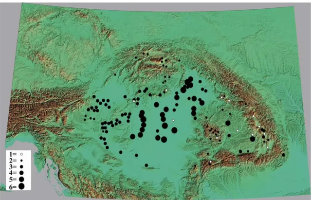
In our work, we selected pollen analyses from 137, predominantly new catchment basins in the Carpathian Basin for our medieval, Hungarian conquest and Migration Period pollen database (Fig. 1.). Thus, we have suitable data sets that can be used for the EPD database, but only 13 of these can be found in the European Pollen Database (Bodor et al. 2000; Juhász 2002).
Fig.1.: The pollen sites that constitute the presented database (scale of original map: 1:1,000,000) 1. ábra: A bemutatott adatbázist alkotó pollen lelőhelyek (eredeti térkép léptéke: 1:1 000 000)
Key / Jelkulcs: 1 = Tlstá Hora, Biele Karpaty, Slovakia, 2 = Kubríková, Západné Beskydy, Slovakia, 3 = Dolina Zlatného potoka, Podbeskydská brázda, Slovakia, 4 = Bobrov, Oravská kotlina, Slovakia, 138 = Trojrohé pleso, Tatra Mts, Slovakia, 5 = Regetovka, Busov, Slovakia, 6 = Kružlová, Ondavská vrchovina, Slovakia, 7 = Hozelec, Popradská kotlina, Slovakia, 8 = Šafárka, Volovské vrchy, Slovakia, 9
= Sivárňa Spišká Magura, Slovakia, 10 = Popradcké pleso, Štrebké pleso, Mts, Slovakia, 11 = Parížske, Slovakia, 12 = Kis-Balaton peatland, Alsópáhok, Hungary, 13 = Kis-Balaton peatland, Zalavár 1, Hungary, 14 = Kis-Balaton peatland, Fenékpuszta, Hungary, 15 = Úsztatómajor peatland, Keszthely, Hungary, 16 = Kis-Balaton peatland, Főnyed, Hungary, 17 = Kis-Balaton peatland, Vörs, Hungary, 18 = peatland, Balatonederics, Hungary, 19 = Baláta lake, Kaszó, Hungary, 20 = Szélmező peatland, Mezőlak, Hungary, 21 = Sárrét peatland, Nádasdladány, Hungary, 22 = Sárrét peatland, Sárkeszi, Hungary, 23 = Nádas lake, Nagybárkány, Hungary, 24 = Kis-Mohos peat-bog, Kelemér, Hungary, 25 = Nagy-Mohos peat-bog, Kelemér, Hungary, 26 = Nagy-Mohos floting mat, Kállósemjén, Hungary, 27 = Nyíres peat- bog, Csaroda, Hungary, 28 = Nyírjes peat-bog, Sirok, Hungary, 29 = Meggyes paleochannel, Jászberény, Hungary, 30 = Halasfenék paleochannel, Zám, Hungary, 31 = Töviskes paleochaennel, Pocsaj, Hungary, 32 = Báb lake, Csaroda, Hungary, 33 = Sarló-hát paleochannel, Tiszagyulaháza, Hungary, 34 = Fehér lake, Kardoskút, Hungary, 35 = marshland core, Bátorliget, Hungary, 36 = marshside profile, Bátorliget, Hungary, 37 = Vörös marshland I. core profile, Császártöltés, Hungary, 38 = = Tisza paleochannel, Tiszacsermely, Hungary, 39 = protected freshwater carbonate profile, Csólyospálos, Hungary, 40 = peat-bog, Szőce, Hungary, 41 = peat-bog, Farkasfa, Hungary, 42 = Tisza paleochannel, Polgár, Hungary, 43 = Vörös-mocsár II. core-profile, Császártöltés, Hungary, 44 = Selyemrét peatland, Ócsa, Hungary, 45 = Kaszálók peatland, Hajós, Hungary, 46 = Fertő lake, Hidegség, Hungary, 47 = peat-mine, Osli, Hungary, 48 = Rokkantföldek paleochannel, Rákóczifalva, Hungary, 49 = Pana paleochannel, Maroslele, Hungary, 50 = Maty paleochannel, Szeged, Hungary, 51 = Kunkápolnás, Nagyiván, Hungary, 52 = Tisza paleochannel, Tiszapüspöki, Hungary, 53 = Tisza paleochannel, Tiszaalpár, Hungary, 54 = Turbuta peatland, Transylvanian Basin, Romania, 55 = Preluca Tiganului peat-bog, Gutaiului Mts, Romania, 56 = Steregoiu peat-bog, Gutaiului Mts, Romania, 57 = lezerul Caliman, Caliman Mts, Romania, 58 = Taul dintre Brazi, Retezat Mts, Romania, 59 = Ic Ponor, Apuseni Mts, Romania, 60 = Padis Ponor I, Apuseni Mts, Romania, 61 = Padis Ponor II, Apuseni Mts, Romania, 62 = Padis Plateau, Apuseni Mts, Romania, 63 = Bergerie, Apuseni Mts, Romania, 64 = Capatana, Apuseni Mts, Romania, 65 = Molhasul Mare, Apuseni Mts, Romania, 66 = Calineasa, Apuseni Mts, Romania, 67 = Pietrele Onachii, Apuseni Mts, Romania, 68 = Taul Zanogutii, Apuseni Mts, Romania, 69 = Semenic, Banat Mts, Romania, 70 = Pesteana, Poiana Rusca Mts, Romania, 71 = St Anna lake, Harghita Mts, Romania, 72 = Avrig-1, Fagaras basin, Romania, 73 = Bisoca, Curbura, Romania, 74 = Mohos peatland, Harghita Mts, Romania, 75 = Luci peatland, Harghita Mts, Romania, 76 = Poiana Stiol 3, Rodnei Mts, Romania, 77 = Drava paleochannel, Drávaszabolcs, Hungary, 78 = Lankóczi paleochannel, Berzence, 79 = Drava paleochannel, Barcs, 80 = Drava paleohannel, Drávatamás, 81 = Danube paleochannel, Draž, Croatia, 82 = Danube paleochannel, Novi Sad, Serbia, 83 = Batta paleochannel, Decs - Ete, Hungary, 84 = Balaton lake, Balatonkeresztúr, Hungary, 85 = Balaton lake, Balatonboglár, Hungary, 86 = Balaton lake, Zamárdi, Hungary, 87. Sárvíz peatland, Soponya, Hungary, 88 = Sárvíz peatland, Sárszentmihály, Hungary, 89 = Nádas lake, Gárdony, Hungary, 90 = Kaszálók peatland, Hajós, Hungary, 91= Országút felőli dűlő, Rábapatona, Hungary, 92 = Kismalom lake, Sopron, Hungary, 93 = Égeres peatland, Velem, Hungary, 94 = Borzó creek, Zanat, Hungary, 95
= Surány creek, Nemesbőd, Hungary 96 = Hosszú creek, Vát, Hungary, 97 = Marcal creek, Kemenespálfa, Hungary, 98 = Barbacsi lake, Barbacs, Hungary, 99 = peat-bog, Csikóvár, Hungary, 100 = Búbánat creek, Esztergom, Hungary, 101 = Dera creek, Pilisszentkereszt, Hungary, 102 = Sirbik domb, Visegrád, Hungary, 103 = Ménes creek, Karancsság, Hungary, 104 = Fort garden, Szécsény, Hungary, 105 = Nagy lake, Ipolyszög, Hungary, 106 = Petény cave, Peskő, Hungary, 107 = Rejtek cave, Répáshuta, Hungary, 108 = Aggtelek lake, Aggtelek, Hungary, 109 = Martonyi creek, Martonyi, Hungary, 110 = Bivaly lake, Rákóczifalva, Hungary, 111 = Bai 1 Mai, Haiu, Romania, 112 = Daru marshland, Bagamér, Hungary, 113 = paleochannel, Karos, Hungary, 114 = Latorca paleochannel, Szirénfalva, Ukraina, 115 = paleochannel, Pallagcsa, Hungary, 116 = paleochannel, Karcsa, Hungary, 117 = paleochannel, Viss, Hungary, 118 = paleochannel, Zalkod, Hungary, 119 = Nyír peatland, Reci, Romania, 120 = Tăul fără fund peatland, Bǎgǎu, Romania, 121 = Kerek lake, Sânpau, Hungary, 122 = Mlastina Csemő, Vrabia, Romania, 123 = Mănăstirea franciscanilor, Şumuleu Ciuc, Romania, 124 = Mlaştinǎ, Delniţa, Romania, 125 =
Archeometriai Műhely 2019/XVI/3. 248
marshland, Comăneşti, Romania, 126 = Turbaria Calul de Piatra, Bistra, Romania, 127 = Mlaştina eutrofă de la Hǎrman, Hǎrman, Romania, 128 = Mureş, paleochannel, Sâncraiu de Mureş, Romania, 129 = Lacul Racului/Rat, Sec, Romania, 130 = Padiş Ponor II, Apuseni Mt, Romania, 131 = Rohr – Heugraben, Austria, 132 = Külső lake I, Tihany,Hungary, 133 = Külső lake II., Tihany, Hungary, 134 = Danube paleochannel, Tököl, Hungary, 135 = Mặguruci cave, Răstoci, Romania, 136 = Uver mlaştinǎ, Racu, Romania, 137 = Mlaştina de la Iaz, Plopiş, Romania
Also, many of the Hungarian sections were incorrectly recorded because the first reports (e.g.
Jakab et al. 2005) reported incorrect coordinates and altitudes. The latter mistakes were made because the first publications, in several cases, reported the materials without participating in the drilling and the extraction of the samples (Sümegi et al. 2008).
The pollen analysis works of the Carpathian Basin, including Hungary, were selected in the following steps:
1.) The stratigraphy of the catchment basin was explored with a drilling rig providing undisturbed core samples. If the type of drill was not reported, the test results were not considered. As we pointed out earlier in the pollen drilling in Hungary, we had to omit all pollen analysis work until the end of the 1980s due to inadequate sampling both in Nyírség, Bodrogköz or in different parts of the country (Braun et al. 1993; Sümegi 2001). We took only into consideration the works of the Geoarchaeological and Environmental History Team, which is a joint research team of the Institute of Archaeology of the Hungarian Academy of Sciences and the Department of Geology and Palaeontology of the University of Szeged, and its predecessor the Debrecen Palaeoecological Group (Sümegi 2001). Apart from the work of the researchers trained in these groups (Mihály Braun, Enikő Magyari), we could only consider the works of Tibor Cserny and Elvira Bodor in Hungary. This is mainly because Tibor Cserny utilized the drilling equipment we have developed (Sümegi 2001), among other things during his drilling, and was able to provide undisturbed cores for the pollen research work of Zsófia Medzihradszky & Járainé-Komlódi (1996).
2.) For undisturbed core sampling, it was essential that Lycopodium tablet digestion was performed during pollen processing and that a minimum of 300/500 terrestrial plant pollen was counted from a sample. Only pollen analytical work where the pollen concentration was determined using the Lycopodium spore tablet method (Stockmarr 1971) was considered. It has been used extensively in pollen analytics in Europe and globally since the 1970s, except in Hungary, several areas of Yugoslavia, Romania, and Bulgaria. As a result, the results of the Hungarian pollen analyses were not considered reliable and acceptable, even internationally in the 1990s (Berglund et al. 1996).
3.) Only the sections where correct bulk or AMS radiocarbon analyses were performed in first-class laboratories were reported and reported with primary physical measurement data, measurement depth, and measurement code number.
4.) Only the pollen data where the position of the catchment basin and the undisturbed core drilling were given in coordinates in the publications were considered. It is impossible to reconstruct the locations of the drillings in the absence of the coordinates. This was the case with the Hungarian pollen drilling data until the end of the 1980s. No one in Hungary fulfilled this fundamental condition except the Debrecen Palaeoecological Group, the Geoarchaeological and Environmental History Group in Budapest and Szeged, and their students and Tibor Cserny and Elvira Bodor (Hungarian Geological Institute). It is no coincidence that pollen data from Hungary were not considered reliable in international research (Berglund et al.
1996).
5.) The size of the catchment basin was also considered, so the boreholes drilled into the Balaton riverbed could not be considered as the size of the lake is too large. In the case of internationally used catchment basin selection, river basins should have been excluded from our analysis due to pollen banding uncertainties. Without these, however, pollen data from significant areas of the Great Hungarian Plain and the Little Hungarian Plain would not have been available. Although pollen data can be used primarily to reconstruct regional crop production, these data can be used to demarcate and localize crop production within a maximum range of 10-100 km2. The otherwise perfectly correct boreholes and excellent pollen results in the 600 km2 main basin of the Balaton (Cserny & Bodor 2000) were not used in our work because we would have gotten data from the whole basin, about 300,000 km2.
The setting up of the database, therefore, required comparisons of samples from different parts of the Carpathian Basin, extracted with the same methods and extracted by drilling to ensure mix-free sampling and dated by independent chronological methods. As a result, analyses that did not reach this standard were excluded. This was the only way for us to achieve correct and comparable results. Of course, this is a painful process that has highlighted that most Hungarian pollen analyses conducted in the second half of the 20th century were unsuitable for international comparison (Berglund et al. 1996) and could not solve even a fundamental issue. The
erroneous results and fallbacks of a generation have been eliminated through the work of the new generation between 1986 and 2006 (Törőcsik &
Sümegi 2016).
6.) 137 radiocarbon-dated pollen sites and sequences, which have been published and created so far during the processing of our research group, have been extracted to the database. The development of the database was not problem-free, and, based on the experience so far, there were problems with more pollen sections in Hungary.
Particularly the borehole at the border of Tiszagyula, considered essential for the development of the entire Hungarian Great Hungarian Plain vegetation, caused the most significant problem. Our first and severe problem is that the drilling profile was projected to different places and areas by the authors of very different composition. Sometimes the pollen data changes were projected to the Tisza valley (Magyari et al.
2010, 2012; Gábris et al. 2001; Gábris & Nagy 2005), sometimes to the Polgár alluvial island about 20 km from the site, and to the Hortobágy region, which is at a distance of at least 60 km from the drilling site and is genetically utterly different from the Tisza Valley (Magyari 2010, 2011; Fekete et al.
2011, 2014). We do not know of any such profile in the Hungarian Great Hungarian Plain, which could represent the development of vegetation in so many diverse regions characterized by different environments, including saline areas, steppes, forest steppes, forests, all with a good water supply, hydromorphic soil-covered neotectonical depression, an oxbow lake surrounded by a grove forest, and the studied sections come from several kilometres from the places where pollen results were projected.
This problem is increased by the fact that in different articles the location with the same coordinates on the maps shown is once at the mouth of the Sajó, once at 20 km from Polgár, once at a height of Tiszafüred about 50 km to the south (Magyari 2011), other times on the right bank of the Tisza (Magyari 2010) or the left bank (Magyari et al. 2012), always as if the sites were closer to saline or steppe areas or the Polgár archaeological sites (Magyari et al. 2010).
Also, it should be noted that no pollen analysis work focused on the last 2000 years, including the age of the Hungarian conquest, except the Transylvanian project (2014-2018) led by the archaeologist Elek Benkő, the Transdanubian project (2012-2016) led by the archaeologist Gyöngyi Kovács, and the projects led by Professor Pál Sümegi: the Hungarian Environmental History project (2002-2006), the Tóköz project (2004-2008) and the Bodrogköz project (2006-2009). This is tremendously true for the peripheral states of the
Carpathian Basin and for the successor states that broke away from the Kingdom of Hungary, where after Trianon due to the inordinate education of history and the scientifical mindset, this whole historical issue has been and is treated as a political issue. It is no coincidence that the first correct pollen data for the age of the Hungarian conquest comes from the work of a Hungarian-British project (1993-1996) (Willis et al. 1998, Sümegi 1998, 2000). With this work, we wish to continue the journey begun in 1993 with the support of the British Council - OMFB, including the pioneering work of Professor Katherine Jane Willis from Oxford, honouring her achievements, which set the new ground for pollen research in Hungary and produced internationally valuable results since the mid-1990s.
Results
For the last 1500-1600 years of the 137 pollen sites, the following findings regarding the distribution of Cerealia pollen were made. We chose to present the spatial and temporal distribution of the dominance (proportion) of pollen in cereals because it is one of the best indicators of human activity, the existence of a farming community, and the number of farming communities in the area. The temporal resolution has reached a decade resolution in about 50 sections, but for most sections, sampling and processing have resulted in calibrated timelines, with a margin of error of 60-100 years. Thus, we only discussed pollen data for the entire basin for the last 1500-1600 years in a centennial resolution (Sümegi et al. 2016). Before our National Science Fund application launched in 2002, we did not produce a map series based on the change in pollen ratio based on such a database, as we did not have any adequate sections with radiocarbon data. Thus, there was no dated pollen database available which we could compare to in Hungary or abroad in 2002.
However, we have already developed a considerable number of first comparative databases on the Mesolithic and Neolithic for the beginning of the Holocene (Sümegi 1996, 1998, 1999, 2004, 2005, 2007, 2011).
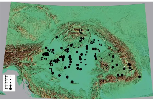
IV-Vth century (350–450 cal AD) (Fig. 2.) The proportion of cereal pollen in Transdanubia, on the Danube Great Hungarian Plain, above all in the Danube Valley, is more than 2%. In the Tisza Valley, the foreground of the Northern Carpathians, the dominance of cereals decreased sharply towards the Subcarpathian region, although in the Tisza Valley and in the Southern Great Hungarian Plain there was still a relatively large proportion of cereals, but in the North-eastern Great Hungarian Plain, in the high and middle mountains, there was a minimum cereal dominance of less than 0.5%
(Fig. 2.).
Archeometriai Műhely 2019/XVI/3. 250
Fig. 2.: Cerealia’s summa pollen dominance from different pollen sites in the Carpathian Basin during the transition time of IV/V centuries AD (350 – 450 AD years)
1 = there is no data or dominance of Cerelia = 0 %, 2 = dominance of Cerealia between 0.0 and 0.5 %, 3 = dominance of Cerealia between 0.5 and 1.0 %, 4 = dominance of Cerealia between 1.0 and 2.0 %, 5 = dominance of Cerealia between 2.0 and 4.0 %
2. ábra: A gabona (cerealia) pollenek összdominanciájának változása a pollenszelvényekben a Kárpát- medencében a Krisztus utáni IV/V. század fordulóján
1 = nincs az adott korra vonatkozó adat, vagy a Cerealia dominancia = 0 %, 2 = A Cerealia dominancia 0,0 és 0,5 % közötti, 3 = A Cerealia dominancia 0,5 és 1,0 % közötti, 4 = A Cerealia dominancia 1,0 és 2,0 % közötti, 5 = A Cerealia dominancia 2,0 és 4,0 % közötti,
The same value was observed in the Drava valley and throughout Transylvania, except in the Mezőség, where a greater cereal pollen dominance was observed. As a result, we can count on a more settled human community and farming in Transdanubia, in the Great Hungarian Plain region of the Danube Valley and in the Mezőség region during this period. As a result, the proportion of crop production communities was minimal in the eastern half of the Carpathian Basin, in the vast majority of the Great Hungarian Plain and Transylvania. In these areas, livestock grazing may have dominated during this period and/or have a low population density during the first century of the Migration period.
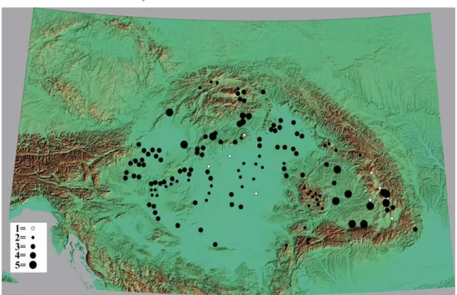
V-VIth century (450–550 cal AD) (Fig. 3.) The proportion of cereal pollens decreased in the whole basin, but in Transdanubia, above all, in the Keszthely culture (Sümegi et al. 2009a, 2011), the proportion of cereal pollens remained significant, and in the Prealpine region it remained relatively
significant (Fig. 3.). In the North Hungarian Mountains, in the Great Hungarian Plain and the Tisza Valley, relatively steady low levels of cereal pollen dominance occurred. However, in Transylvania, in the Northern Carpathians, in the North-eastern Great Hungarian Plain, wholly subordinate cereal pollen dominance occurred during this period. In the wake of pollen dominance, we have to reckon with the remains of the ancient imperial cultures, the communities with antique cultivation experience and the ability to pass it on, and the scattering of them in the western part of Transdanubia (Sümegi et al. 2009a, 2011).
In the western part of the North Hungarian Mountains, in isolation in the Subcarpathian region, the percentage of cereal pollen increased minimally. In this area, marked by Quadi and Marcomanni settlements in earlier Roman sources, a local population increase can be reconstructed in the V-VIth century. Of course, based on these scientific data, it is impossible to tell who lived in this Subcarpathian region during this century.
Fig. 3.: Cerealia’s summa pollen dominance from different pollen sites in the Carpathian Basin during the transition time of V/VIth centuries AD (450 – 550 AD years)
(For distribution vakues, see Fig. 2 – also for Figs. 4-14)
3. ábra: A gabona (cerealia) pollenek összdominanciájának változása a pollenszelvényekben a Kárpát- medencében a Krisztus utáni V/VI. század fordulóján
(A mennyiségi adatok jelkulcsának feloldásához ld. a 2 ábrát, amelyet a zovábbialban (4-14 ábra) következetesern használunk
However, archaeological and possibly historical sources reveal, or at least make probable, which community’s activity resulted in this increase in relative cereal pollen ratio due to more intensive farming (Fig. 3.).
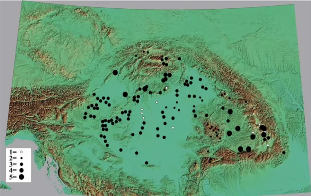
VI-VIIth century (550–650 cal AD) (Fig. 4.) The proportion of cereal pollen in pollen deposits continued to decline throughout the basin, with relatively balanced low-level cereal production. At the same time, lower pollen dominance can be observed in the Balaton region, in the Prealpine region and the southern Great Hungarian Plain, both in the Tisza and the Danube valleys (Fig. 4.).
As a result, it appeared as if there was no longer a centre, but more independent territorial develop- ment at the end of the VIth century in the Carpathian Basin, which was fully occupied by the Avars at the beginning of the VIIth century. Based on the distribution of cereal pollen, a cultivation centre was established in the Danube-Tisza region, near Lake Balaton and in the Little Hungarian Plain
– Prealpine region (Fig. 4.). It cannot be ruled out that these pollen cultivation centres were already developed in the Avar Empire and were linked to the process of decentralization, culminating in the middle of the VIIIth century. (Curta 2006; Preiser- Kapler 2018).
VII-VIIIth century (650–750 cal AD) (Fig. 5.) Based on the distribution of cereal pollen, a cultivation centre was established in the southern part of the Danube-Tisza region, in the southern part of the Lake Balaton and in the region of the Little Hungarian Plain (Fig. 5.). Compared to the previous century, cultivation centres based on pollen proportions have continued to evolve based on the proportion of cereal pollen, and these processes were already clearly linked to the process of decentralization in the Avar Empire culminating in the mid-VIIIth century (Pohl 1988; Curta 2006;
Preiser-Kapler 2018). The increase in the proportion of cereal pollen in eastern Transylvania is particularly noticeable (Fig. 5.).
Archeometriai Műhely 2019/XVI/3. 252
Fig. 4.: Cerealia’s summa pollen dominance from different pollen sites in the Carpathian Basin during the transition time of VI/VIIth centuries AD (550 – 650 AD years)
4. ábra: A gabona (cerealia) pollenek összdominanciájának változása a pollenszelvényekben a Kárpát-medencében a Krisztus utáni VI/VII. század fordulóján
Fig. 5.: Cerealia’s summa pollen dominance from different pollen sites in the Carpathian Basin during the transition time of VII/VIIIth centuries AD (650 – 750 AD years)
5. ábra: A gabona (cerealia) pollenek összdominanciájának változása a pollenszelvényekben a Kárpát-medencében a Krisztus utáni VII/VIII. század fordulóján
Fig. 6.: Cerealia’s summa pollen dominance from different pollen sites in the Carpathian Basin during the transition time of VIII/IXth centuries AD (750 – 850 AD years)
6. ábra: A gabona (cerealia) pollenek összdominanciájának változása a pollenszelvényekben a Kárpát-medencében a Krisztus utáni VIII/IX. század fordulóján
Fig. 7.: Cerealia’s summa pollen dominance from different pollen sites in the Carpathian Basin during the transition time of IX/Xth centuries AD (850 – 950 AD years)
7. ábra: A gabona (cerealia) pollenek összdominanciájának változása a pollenszelvényekben a Kárpát-medencében a Krisztus utáni IX/X. század fordulóján
Archeometriai Műhely 2019/XVI/3. 254
As a result, we have been able to reconstruct the existence of a major community of farmers in this area. It seems that agriculture has come to the forefront in diffuse centres and around them during the driest period (or perhaps just after the dry period) of the VIIth and VIIIth centuries (Preiser- Kapler 2017, 2018). In our opinion, the multi-centre distribution of cereal pollens within the Avar Empire, which dominated the entire Carpathian Basin, is like the development of polycentric metallurgy (Diam 2000, 2003) and could have been linked to the process of social decentralization.
(Pohl 1988; Curta 2006; Preiser-Kapler 2018). At the same time, it is also clear that the most significant pollen ratios were found in the central part of the Great Hungarian Plain, in the Danube- Tisza Interfluve, in the southern part of the Great Hungarian Plain and in the eastern part of Transylvania. As a result, a larger farming community and a larger population are expected in these areas during the Late Avar period.
VIII-IXth century (750–850 cal AD) (Fig. 6.) The percentage of cereals in the sites and their dominance at the turn of the VIII-IXth century showed minimal grain production in the high mountains, in the higher Carpathian regions, in the Upper Tisza Region, in Hortobágy, in the southern part of the Transylvanian Basin, in the Drava Valley, in the Upper Tisza region (Fig. 6.). It is likely that there was no actual cereal production in these areas during this period, but that a minimum cereal dominance of less than 0.5% may have resulted from sediment supply from remote areas.
The same low dominance of remote supply occurs in most of the middle mountain zone, even in regions considered by many historians as a settlement zone for Slavic farming (Bartha 1984;
Fridvalszky 2014). In contrast to these areas characterized by a minimum amount of cereal pollen, the most significant cereal pollen ratio (above 2%) was formed in the Tisza Valley in its central and southern parts (Fig. 6.). Also, in the Danube Valley, in the Little Hungarian Plain, in the southern shore of Lake Balaton, in Nyírség and in the Csík Basin, a relatively significant 1-2% of cereal pollen was formed. We can infer the presence of a significant farming population at the turn of the VIII-IXth century in the Tisza valley, generally in the Great Hungarian Plain, in the southern shore of Lake Balaton, in the Little Hungarian Plain, the gravel cover of Western Hungary and the Csík Basin. As a result, in these areas, we can count on a significant population of cultivated farmers in the VIIIth century, at the end of the IXth century, at the time of the collapse of the Avar Empire.
It is striking that the highest proportion of cereal pollen was found in one of the driest parts of the Great Hungarian Plain in the eco-region developed
in the central and southern part of the Tisza Valley.
Even these data are in complete contradiction with the uncontrolled dehydration hypothesis (Rácz 1993, 2008; Győrffy and Zólyomi, 1994), which they sought to substantiate with no specific chronological data (Jakab et al. 2009, 2010) and clearly demonstrate that the collapse of the Avar Empire requires the study of complex socio- economic processes (Diam 2000, 2003; Curta 2006;
Pohl 2015; Preiser-Kapler 2016, 2018), rather than the one-sided and one-factor disaster theory focusing on dehydration (Sümegi et al. 2009b, 2016b; Sümegi 2011).
IX-Xth century (850–950 cal AD) (Fig. 7.) At the turn of the IX-Xth century, precisely in the second half of the IXth century and in the first half of the Xth century, this cereal pollen aspect ratio changed significantly (Fig. 7.). In the Upper Tisza Region, in the Nyírség, in the Tisza and Danube valleys, in several parts of the Transylvanian Basin, the proportion of cereal pollen developed between 2 and 3%. In Transdanubia, the proportion of cereal pollen was lower than that of the former, relatively significant area, but lower than the Great Hungarian Plain, but it was even to the Drava Valley, to the north and west peripheries.
This clearly shows that at the turn of the IX-Xth century, pollen data showed a significant increase in an east-west direction in agriculture and grain production, especially in the Upper Tisza region.
Based on a factor independent of these historical sources, at the turn of the IX-Xth century, significant arable farming and grain cultivating community settled in the Great Hungarian Plain, primarily in the Upper Tisza region, in the Tisza Valley, in the Danube Valley, and in Transylvania (Fig. 7.).
Of course, these data do not allow us to infer the origin of the settled farmer and grain cultivating communities. However, it is true that in the age of the Hungarian conquest and at the turn of the IX- Xth century, the proportion of cereal pollen, which refers to cultivation and grain cultivating, has increased significantly in the Great Plain, especially in its north-eastern region and in several places in Transylvania. As a result, significant agricultural populations may have arrived in the basin during the Hungarian conquest, and the Hungarian leaders could have reorganized the activities of the peoples living there, and based on the location of pollen data sections, most of the basin was occupied and cultivated at least up to 600 meters above sea level by them.
Our pollen data confirm the archaeobotanical and pollen data of Gyulai (1994), Willis et al. (1998), and Sümegi (1998, 2000) on crop production during the Hungarian conquest. It also confirms the archaeological and ethnographic data of Balassa
(1973, 1994) and Müller (1992, 2000) on agriculture during the Hungarian conquest.
Especially the findings of crop production, first of all, cereal production from archaeological sites of the Hungarian conquest period (Sági & Füzes 1967;
Hartyányi et al. 1968, 1974; Hartyányi 1983;
Gyulai 1994, 2001, 2010) are of great importance because they provide decisive evidence for crop production during the Hungarian conquest.
According to pollen data, rye (Secale), wheat (Triticum type), barley (Hordeum type) were present among the cultivated cereals of Hungarians during the Hungarian conquest. This is also supported by plant remains from archaeological sites dating back to the Hungarian conquest (Gyulai 1994, 2001, 2010). Millet remains have been found among archaeobotanical finds, but we cannot provide pollen data for this. Our pollen results indicate the presence of a significant cereal grower and farmer population during the Hungarian conquest period and, also, a significant population increase over the last century in the Carpathian Basin, but above all in the Great Hungarian Plain and the Transylvanian Basin (Fig. 7.). Pollen data clearly support the ideas of Bálint (1989) on the establishment of farmer and agricultural communities during the Hungarian conquest and the inclusion of areas suitable for agricultural production and soil types.
X-XIth century (950 – 1050 cal AD) (Fig. 8.) At the turn of the X-XIth century (Fig. 8.) the proportion of cereal pollen changed in Transdanubia, and the same proportion of cereal pollen was found in the Little Hungarian Plain, in the .Prealpine region, in the Balaton region, in the Mezőföld and the Drava valley like in the Great Hungarian Plain and Transylvania. The higher proportion of cereal pollen that was present in the eastern half of the Carpathian Basin, in the Great Plain and the Transylvanian Basin at the turn of the IX-Xth centuries now extended to the western half of the basin, and consequently the farming communities and their way of life were evenly distributed throughout the basin. Due to the uniformly significant proportion of cereal pollen covering the whole Carpathian Basin, we can expect a uniformly high population density throughout the basin (Fig. 8.).
The processes revealed during the Hungarian conquest extended to the entire basin during this century. It is of great importance for our environmental history studies that due to the significant share of cereal pollen in Transylvania and Székely Land, we can expect a significant population and significant cultivation during the formation of the medieval Hungarian Kingdom (Fig. 8.). The proportion of cereal pollen also
increased significantly in the middle mountain region, which resulted in the further development of the middle mountain farming system established during the Hungarian conquest, and the development of agricultural activities in the upper middle mountain region. The extremely subordinate background cereal pollen supply rate remained only in the high-altitude region.
XI-XIIth century (1050–1150 cal AD) (Fig. 9.) At the turn of the XI-XIIth century (Fig. 9.), the proportion of cereal pollen increased uniformly throughout the basin. Even in the valleys of the high mountains, in the higher zones of the middle mountains, the proportion of cereal pollens increased significantly (Fig. 9.). Throughout the Carpathian Basin, this pollen composition and spatial pattern of cereal pollen may have resulted in a significant population increase and the emergence of agriculture. Except for areas and regions with the least suitable and fertile soil (pebble or acidic peat covered) for cultivation, there was a significant increase in the percentage of cereal pollen.
By the turn of the XI-XIIth century, the entire agricultural and settlement system had developed in the Kingdom of Hungary, extending to the edge of the high mountains (Fig. 9.). Based on these data, a consistent and significant population has been formed throughout the Carpathian Basin, and these data may indicate the functioning of a central leadership with proper governance mechanisms.
XII-XIIIth century (1150–1250 cal AD) (Fig. 10.) At the turn of the XII-XIIIth century, the proportion of cereal pollens changed dramatically (Fig. 10.). In Transtisza, in the Upper Tisza Region and the Tisza Valley, the proportion of cereal pollen decreased significantly despite the excellent and appropriate soil conditions. In the rest of the Carpathian Basin, the proportion of cereal pollen did not change significantly compared to the previous century, moreover in the middle mountain region, in protected areas like Transylvanian Basin, Székely Land, Lake Balaton, Sárrét region, the amount of cereal pollen dominance even increased (Fig. 10.).
Due to the centennial resolution, it is not possible to decide whether the change of the system of estates or as a result of the Mongol invasion of Europe, the dominance of cereal pollen has changed compared to the previous century. Whatever change caused the transformation, agriculture and grain production in the Tisza region changed the most, and in the Tisza Valley, neither the population density nor the cultivation focused on grain production fall back in the rest of the basin. If the Mongol invasion of Europe altered the spatial distribution of the pollen dominance of the grain, the most significant losses occurred in the Transtisza and the Tisza valley.
Archeometriai Műhely 2019/XVI/3. 256
Fig. 8.: Cerealia’s summa pollen dominance from different pollen sites in the Carpathian Basin during the transition time of X/XIth centuries AD (950 – 1050 AD years)
8. ábra: A gabona (cerealia) pollenek összdominanciájának változása a pollenszelvényekben a Kárpát-medencében a Krisztus utáni X/XI. század fordulóján
Fig. 9.: Cerealia’s summa pollen dominance from different pollen sites in the Carpathian Basin during the transition time of XI/XIIth centuries AD (1050 – 1150 AD years)
9. ábra: A gabona (cerealia) pollenek összdominanciájának változása a pollenszelvényekben a Kárpát-medencében a Krisztus utáni XI/XII. század fordulóján
Fig. 10.: Cerealia’s summa pollen dominance from different pollen sites in the Carpathian Basin during the transition time of XII/XIIIth centuries AD (1150 – 1250 AD years)
10. ábra: A gabona (cerealia) pollenek összdominanciájának változása a pollenszelvényekben a Kárpát-medencében a Krisztus utáni XII/XIII. század fordulóján
Fig. 11.: Cerealia’s summa pollen dominance from different pollen sites in the Carpathian Basin during the transition time of XIII/XIVth centuries AD (1250 – 1350 AD years)
11. ábra: A gabona (cerealia) pollenek összdominanciájának változása a pollenszelvényekben a Kárpát-medencében a Krisztus utáni XIII/XIV. század fordulóján
Archeometriai Műhely 2019/XVI/3. 258
In other areas, either the decline in population or the replacement of the population was not as forceful, and the immigration of the population took place much faster after the Mongol invasion of Europe than in the centre and eastern part of the Great Hungarian Plain.
XIII-XIVth century (1250–1350 cal AD) (Fig. 11.)
At the turn of the XIII-XIVth century, the proportion of cereal pollens again changed dramatically (Fig. 11.). In the middle section of the Tisza valley, the pollen ratio increased sharply, but in the Transtisza region, above all in the Upper Tisza region, it did not return to the typical dominant cereal pollen values of the XI-XIIth century. There is also a substantial decline in the river valleys, the Drava valley, the upper and lower part of the Rába, along the Körös rivers, in the Upper Tisza Region, and on the Danube part of the Great Hungarian Plain. Several more hypotheses can be assumed based on these cereal pollen changes, but each requires further investigation or analysis of historical sources. At the same time, based on earlier assumptions and recent surface morphological analyses modelling, though not tested, water history and climate history data (Réthly 1963, 1970, 1998-1999; Bodor et al. 2008;
Rácz 2009, 2011; Pinke et al. 2016, 2017) in the Tisza river, in the Körös valley, and possibly in other river valleys, such as the valleys of the Rába, Danube and Drava rivers, arable land was flooded due to the significant rainfall during this period. As a result of these climate changes, environmental changes have led to a shift from arable farming and grain cultivating to meadow and pasture farming in several areas, leading to a reduction in cereal pollen rates in this region, particularly in river valleys.
This seems to be supported by the stronger dominance of cereal pollen at the pollen sites in higher altitudes during this period (Fig. 11.).
However, given the problem of single-factor environmental history approaches (Popper 1962, 1972, 2005; Birks & Birks, 1980), there are several factors that need to be considered in the context of these changes. Thus, it is also necessary to include the social processes according to which early town and market town development may have started during this period (Major 1966; Kubinyi, 1971, 1996, 2000; Benkő, 1997). It cannot be ruled out that the two processes evolved in parallel and caused the transformation of agriculture in the indicated areas and pushed the cereal production into the background, but these data must be evaluated together with the archaeozoological data for each region (Matolcsi 1973, 1982; Bökönyi 1974, 1978, 1994; Red 1983; Bartosiewicz 2006). It is only through these science-based multiproxy data and studies, as well as historical and medieval
archaeological analyses of the individual areas that we can determine what role these processes, or a combination of these, or other social, natural processes, may have been played in these spatial changes in the cereal pollen ratio at the turn of the XIII-XIVth century.
XIV-XVth century (1350–1450 cal AD) (Fig. 12.) The trends from the turn of the XIII-XIVth century continued with minor changes at the turn of the XVI-XVth century. However, it should be borne in mind that between the XIV-XVth century, the overlap is quite significant based on radiocarbon studies, even with the most advanced special AMS (TAM) analyses (Molnár et al. 2013), which has only a minimal physical measurement margin of error. This chronological overlap was mainly found in the places where the devastation associated with the Ottoman occupation in the XVIth century has left visible traces (for example, the sediment section of the oxbow lake located near the ruined medieval market town of Decs-Ete: Sümegi et al. 2016). As a result, the XVth century horizon before the level of destruction could be separated by a combination of stratification and chronological methods.
Even with this distinction, we must be aware that during the XIV-XVth century, the typical settlement of historical Hungary, including the town and market town development, was the most critical social trend which controlled the economy, agriculture, and farming (Major 1966; Kubinyi 1971, 1996, 2000; Benkő 1997). It would be essential to analyse this time horizon since, from this end of the Middle Ages, there is already considerable written material available (Szabó 1969). Thus, comparative analysis of environmental history and written materials would represent a significant step forward in modelling the development of economic space. Namely, based on pollen analyses at the borders of market towns and larger marketplaces (centres), the Thünen economic circle structure (Thünen 1826) typical of medieval towns, has already been established in the Kingdom of Hungary (Sümegi et al. 2016). However, as a result of the mosaic environment and the development of the marketplace associated with river valleys and crossings, the economic space around the central location is made up of mosaics known from fractal geometry instead of mosaics known as elongated and non-homogeneous bands (Sümegi 1996; Sümegi in Raczky et al. 2010;
Sümegi et al. 2012, 2013). As a result, many elements of the natural environment have likely survived in the economic space around towns and market towns, meaning that the economic space was not homogeneous. All these processes are probably reflected in the spatial distribution of the pollen ratio of the cereals plotted on the pollen database (Fig. 12.).
Fig. 12.: Cerealia’s summa pollen dominance from different pollen sites in the Carpathian Basin during the transition time of XIV/XVth centuries AD (1350 – 1450 AD years)
12. ábra: A gabona (cerealia) pollenek összdominanciájának változása a pollenszelvényekben a Kárpát-medencében a Krisztus utáni XIV/XV. század fordulóján
Fig.13.: Cerealia’s summa pollen dominance from different pollen sites in the Carpathian Basin during the transition time of XV/XVIth centuries AD (1450 – 1550 AD years)
13. ábra: A gabona (cerealia) pollenek összdominanciájának változása a pollenszelvényekben a Kárpát-medencében a Krisztus utáni XV/XVI. század fordulóján
Archeometriai Műhely 2019/XVI/3. 260
Fig. 14.: Cerealia’s summa pollen dominance from different pollen sites in the Carpathian Basin during the transition time of XVI/XVIIth centuries AD (1550 – 1650 AD years)
14. ábra: A gabona (cerealia) pollenek összdominanciájának változása a pollenszelvényekben a Kárpát-medencében a Krisztus utáni XVI/XVII. század fordulóján
Still, for these, more in-depth analyses of the relationship between settlements and pollen sites need to be explored and discussed in detail.
XV-XVIth century (1450–1550 cal AD) (Fig. 13.) The proportion of cereal pollen in the southern and central basin, but even in the Little Hungarian Plain and the .Prealpine region decreased drastically during this period from 1450 to 1550 (Fig. 13.). It only endured to a significant extent in the Transylvanian parts and the middle mountains. At the same time, it should be pointed out that due to the margin of error of radiocarbon measurements, it is extremely difficult to make a centennial distinction at the end of the Middle Ages. We have to take into account that between the XVth and XVIth centuries, as between the XIVth and XVth centuries, the overlap is quite significant based on radiocarbon studies, even with the most modern AMS (TAM) analyzes with minimal physical measurement margin (Molnár et al. 2013). This chronological overlap was found mainly in places where the destruction associated with the XVIth century Ottoman occupation left visible traces (Sümegi et al. 2019). Based on the level of destruction and historical sources, we were able to separate this horizon with a combination of stratigraphical and chronological methods. The other places were the lakes and bogs with
significant biogenic and/or abiogenic accumulation, which allowed centennial or even decadal resolution (like the section in the castle lake of Pápa, Sümegi et al. 2019).
Most of the sections could not achieve such precise resolution, but pollen material can be evaluated on a centennial scale. Spatially differentiated grain pollen ratio decline is clear based on pollen material and is parallel with Polish pollen analysis and spatial evaluation, where in the XVth century similar spatial differences were found in grain pollen ratios and, consequently, in medieval grain production (Ralska-Jasiewiczowa 2004; Wacznik et al. 2016). There were several reasons for spatial differentiation and a decline in certain areas. It is presumed that the Ice Age (Rácz 1993, 2008;
Grabnet et al. 2008; Wacznik et al. 2016), which has already evolved during this period, also affected the Carpathian Basin. The effect of the Ice Age may likely have varied spatially. For example, the average temperature in late summer decreased, and rainfall increased during the growing season. Their effect on crop production may have been particularly favourable in the southern part of the Carpathian Basin, on the loess plateaus with a total area of several thousand km2 (Törőcsik & Sümegi 2018; Rácz 2019). However, the increased intensity and duration of floods during this period may have
covered broader areas of deeper basins and lasted longer (Kiss 2011, 2012; Kiss & Laszlovszky 2013;
Pinke et al. 2016, 2017). The effect of floods, which increased at the beginning of the Ice Age and increased in time and space, could thus occur in an area of 40-50,000 km2 (Kiss 2011, 2012; Kiss &
Laszlovszky 2013; Pinke et al. 2016, 2017). This is already a significant factor influencing grain production, and it is no coincidence that the decline mainly occurred in the basin-like areas, river valleys, except the flood plain islands, which have island-like features and have fertile soil features (Sümegi et al. 2005). At the same time, the decline in grain pollen ratios and the consequent decline in grain production do not allow us to infer the agricultural crisis in the Carpathian Basin at the end of the Middle Ages. These environmental conditions generated by the Ice Age may have been particularly favourable for the meadow, pasture and hay management that was already present at that time (Rácz 2019). Besides the natural factors, like the effect of the Little Ice Age, humans also had effects on grain production. For example, between 1450-1550, the Ottoman Empire annexed the Balkan-region and the Byzantine Empire and extended the wars, campaigns and robberies to the Carpathian Basin, which already had internal conflicts (Dózsa rebellion). Thus, the restructuring of production due to war uncertainties, the decline of farming, the spread of grazing, decreasing population density and declining numbers in headcount could all have contributed to the decline in grain pollen ratios. However, these factors do not explain, for example, the decline in grain production in the Little Hungarian Plain. As a result, the reduction in grain pollen ratio between 1450 and 1550, which is spatially differentiated but can be detected in basin areas, is mainly due to changes in natural factors, mostly the increase in flood intensity and duration (Kiss 2011, 2012; Kiss
& Laszlovszky 2013; Pinke et al. 2016, 2017).
XVI-XVIIth century (1550–1650 cal AD) (Fig. 14.) The trends from the turn of the XV-XVIth century continued with minor changes at the turn of the XVI-XVIIth century. However, it should be borne in mind that between the XVI-XVIIth century, the overlap is quite significant based on radiocarbon studies, even with the most advanced special AMS (TAM) analyses (Molnár et al. 2013), which has only a minimal physical measurement margin of error.
Thus, XVI. and XVII. centuries are difficult to distinguish from each other with radiocarbon studies, primarily since climate trends of the XVIth century and the consequent changes in agriculture were accomplished during the XVIIth century. In the XVIIth century, the annual average temperature decreased, with significant precipitation in almost all parts of the basin (Sümegi et al. 2009, 2014), but
especially in the middle mountains and hills. Due to an increase in precipitation of about 50-100 mm/year and a decrease in the average temperature of 0.5-0.6 °C, several areas, especially lakes and marshlands, became wet and marshy and unsuitable for grain production (Sümegi et al. 2009a, 2009b, 2014).
At the same time, it is striking that during the Ottoman age and the coldest part of the Little Ice Age, it reached a golden age of viticulture, which is extremely sensitive to temperature factors, sunshine and length of the growing season in the Carpathian Basin (Gyulai 2010). Even though in the XVIIth century fruit production, and especially viticulture, fell significantly in the XVIIth century due to climate change, wars, and continuous frontier struggles and campaigns, especially in Upper Hungary and in the Little Hungarian Plain belonging to the Kingdom of Hungary (Gecsényi 1988; Kalesny, 1993). It may seem strange to talk about the development of vine culture during the Ottoman rule, although it was at this time that the cultivation of table grapes also gained momentum since raisins made from it were a popular delicacy at that time (Árendás 1982). The written data on the cultivation of grapes, grape, wine, pomace pálinka and their tax, and the findings of the grapevines found in Ottoman objects, grape cultivation and processing of the grapevine (Fodor 1998; Csoma 1995; Égető 1993; Hegyi 1976; Káldi-Nagy 1985;
Andrásfalvi, 1961; Székely 1981; Feyér 1981;
Fekete 1981; Pákay 1984; Müller 1982, 2000), the Little Ice Age had a differentiated climatic effect between 1550 and 1650. Likely, the environmental mosaic described in the Carpathian Basin (Sümegi 2016) has led to a deterioration of production conditions in certain areas for grain cultivation and (vine) production during the Ice Age, while in other areas relatively favourable production conditions may have remained mosaic-like. In addition to this, the extent of grain production was influenced by the spread of animal husbandry and rigid grazing at this time (Bartosiewicz & Gál 1997).
The wars extending across the entire Carpathian Basin, the structural change in agriculture, the spread of grazing, the development of the Little Ice Age (Vadas 2011, 2019; Dobrovolný et al. 2010) and the increased intensity and duration of the floods all played a role in the decline in grain production between 1550-1650.
Summary
From the beginning of the Migration period to the end of the Ottoman period, from the turn of the IV- Vth century until to the XVI-XVIIth century, we examined the changes of 1300 years of grain production throughout the Carpathian Basin in a centennial resolution, through 13 centuries, and 137 pollen sites (catchment basins). Based on the spatial
Archeometriai Műhely 2019/XVI/3. 262
distribution of the total cereal pollen ratio, which is related to cultivation, agriculture, population density, and headcount, the following statements were made regarding the age of the Migration period, the Hungarian conquest, the Middle Ages and the Ottoman period.
At the outset of the Migration period, the experience of antique farming, including grain cultivation, probably preserved antique farming communities in western Transdanubia, around Lake Balaton, in the .Prealpine region, and perhaps in the southern part of the Hungarian Little Plain. These communities were probably dissolved during the VIIth century. Grain cultivation did not decline even in the late Avar Empire, moreover, according to dendrochronological, dripstone analysis and catchment basin data, during the driest period, at the turn of the VII-VIIIth century, due to the increase in the proportion of cereal pollen, cultivation expanded to several parts of the basin.
The decentralization of the Avar Empire began in the VIIIth century based on several centres of the dominance of the cereal pollen. However, based on the proportional distribution of the cereal pollen ratio, the ecological crisis of dehydration and the ensuing collapse of the Avar Empire was untenable.
The reason for this, on the one hand, is that there was no severe drought in the VIIIth century, and the early medieval agriculture and settlements led by the Carolingians were built without problems in Transdanubia from the end of the VIIIth century until the beginning of the IXth century, where the Avars were said to have been pushed back by the drought at the same time. On the other hand, in the central and southern parts of the Great Hungarian Plain, where drought was expected to have the strongest impact – a cereal pollen ratio maximum dominated, indicating the most significant and extensive cultivation and population number in the VIII-IXth century (Fig. 6.).
In connection with the age of the Hungarian conquest, according to the proportion of cereal pollens, at the turn of the IX-Xth century, pollen data showed a significant increase in an east-west direction in agriculture and grain production. Based on a factor independent of these historical sources, at the turn of the IX-Xth century, significant arable farming and grain cultivating community settled in the Great Hungarian Plain, primarily in the Upper Tisza region, in the Tisza Valley, in the Danube Valley, and in Transylvania (Fig. 7.). Of course, these data do not allow us to infer the origin of the settled farmer and grain cultivating communities.
However, it is true that in the age of the Hungarian conquest and at the turn of the IX-Xth century, the proportion of cereal pollen, which refers to cultivation and grain cultivating, has increased significantly in the Great Plain, especially in its north-eastern region and in several places in
Transylvania. As a result, significant agricultural populations may have arrived in the basin during the Hungarian conquest, and the Hungarian leaders could have reorganized the activities of the peoples living there.
The remarkable increase in the pollen ratio of cereals suggests a significant increase in population compared to the previous century at the turn of the IX-Xth century, and these data are correlating with previous pollen analyses (Willis et al. 1998). In the following centuries, due to the evenly significant proportion of cereal pollen covering the entire basin area between the X-XIIIth centuries, we can expect an uniformly high population density throughout the basin (Fig. 8.). The processes revealed from the time of the Hungarian conquest extended to the whole basin during these centuries, and the medieval agriculture of the Kingdom of Hungary developed.
From the XIIIth century onwards, trends emerged, which peaked in the XVth century in the Carpathian Basin. The uniform proportion of cereal pollens has changed throughout the basin, and several dominance centres have developed. Likely, the emergence of market towns, major marketplaces (centres) took place during these 250-3000 years, and pollen analyses at the boundaries of the centre cities had already shown the Thünen economic structure of the medieval towns. However, as a result of the mosaic environment and the development of the marketplace associated with river valleys and crossings, the economic space around the central location is made up of mosaics known from fractal geometry, in which natural factors are retained to a greater extent, instead of mosaics known as elongated and non-homogeneous bands. Thus, the medieval economic space could not be homogeneous - natural factors also influenced it.
Related to a cooling, a rainy climate trend, a little ice age which formed at the XVIth century and peaked at the XVIIth century, the precipitation increased by about 50-100 mm/year and the average temperature decreased by 0.5-1.0 °C, and several areas, especially lakes and marshlands, became wet and marshy and unsuitable for grain production.
Despite all the climatic changes, the wars extending across the entire Carpathian Basin, the Ottoman Empire, the Kingdom of Hungary, and the Principality of Transylvania, decreased the dominance and ratio of the cereal pollen in the whole basin. The decline in cereal production, mainly due to worsening climatic conditions, was caused primarily by war uncertainties, a declining population, and a drastic reduction in the number of grain cultivating communities. Significant agriculture and grain cultivation survived only
where natural and social factors protected human communities, like in the upper region of the Kingdom of Hungary and the territory of the Principality of Transylvania.
Acknowledgements
This research were supported by Ministry of Human Capacities, Hungary grant 20391- 3/2018/FEKUSTRAT (University of Szeged, Interdisciplinary Excellence Centre, Institute of Geography and Earth Sciences, Long-term Environmental Changes Research Team) and by the Hungarian National Scientific Fund [grant number OTKA NF 112318].
References
ANDRÁSFALVY, B. (1961): Pehmez. Adatok török kori szőIőkultúránk ismeretéhez. Dunántúli Tudományos Intézet Kiadványa, Kisebb tanulmányok, Pécs, 87–95.
BALASSA, I. (1973): Az eke és a szántás története Magyarországon. Akadémiai Kiadó, Budapest, 630 p.
BALASSA, I. (1994): A magyar földművelés emlékei a 9-10. századból. In: KOVÁCS,L. (szerk.) Honfoglalás és Régészet. Balassi Kiadó, Budapest, 235–246.
BARTOSIEWICZ, L. (2006): Phenotype and age in protohistoric horses: a comparison between Avar and Early Hungarian crania. In: RUSCILLO, D.
ed., Recent Advances in Ageing and Sexing Animal Bones. Oxbow Books, Oxford, 204–215.
BARTOSIEWICZ, L. & GÁL, E. (1997): Animal exploitation in Turkish Period Hungary. In:
GERELYES, I. & KOVÁCS, Gy. eds., Archaeology of the Ottoman Period in Hungary.
Magyar Nemzeti Múzeum Kiadványa, Budapest, 365–376.
BÁLINT, Cs.(1989): Természeti földrajzi tényezők a honfoglaló magyarok megtelepedésében.
Ethnographia 91 35–52.
BELL, M. & WALKER, M.J.C. (1992): Late Quaternary environmental change: human and physical perspectives. Longman Press, Harlow. 273 p.
BENKŐ, E., DEMETER, I., SZÉKELY, A. (1997):
Középkori mezőváros a Székelyföldön. Erdélyi Tudományos Füzetek 223. Kolozsvár, 156 p.
BERGLUND, B.E., BIRKS, H.J.B., RALSKA- JASIEWICZOWA, M., WRIGHT, H.E. (1996):
Palaeoecological Events During the Last 15,000 Years: Regional Synthesis of Palaeoecological Studies of Lakes and Mires in Europe. John Wiley, Chichester, 764 p.
BIRKS, H.J.B. & BIRKS, H.H. (1980): Quaternary palaeoecology. E. Arnold Press, London, 289 p.
BODOR, E., JÁRAINÉ KOMLÓDI, M., MEDVE, A. (2000): Late Glacial and Post-Glacial pollen records and inferred climatic changes from Lake Balaton and the Great Hungarian Plain. Geological Society, London, Special Publications 181 121–
133.
BODOR, E., JAKAB, G., MEDZIHRADSZKY, Zs., SÜMEGI, P., TÖRŐCSIK, T. (2008):
Környezettörténet. In: DOBOS, E. & TEREK, J.
szerk., Élet a folyók között. Miskolci Egyetemi kiadó, Miskolc, 169–177.
BÖKÖNYI, S. (1974): History of domestic mammals in Central and Eastern Europe.
Akadémiai Kiadó, Budapest, 596 p.
BÖKÖNYI S. (1978): Vadakat terelő juhász. Az állattartás története. Magvető Kiadó, Budapest, 159 p.
BÖKÖNYI S. (1994): Magyar állattartás a honfoglalás korában. In: KOVÁCS, L. szerk., Honfoglalás és Régészet. Balassi Kiadó, Budapest, 225–235.
BRAUN, M., SÜMEGI, P., SZŰCS, L., SZÖŐR, Gy. (1993): A kállósemjéni Nagy-Mohos láp fejlődéstörténete (Lápképződés emberi hatásra és az ősláp hipotézis). Jósa András Múzeum Évkönyve 33-35 335–366.
CURTA, F. (2006): Southeastern Europe in the Middle Ages 500-1250. Cambridge Medieval Textbook, Cambridge, 528 p.
CUSHING, E.J. (1967): Late Wisconsin pollen stratigraphy and the glacial sequence in Minnesota.
In: CUSHING, E.J. & WRIGHT, H.E. Quaternary Palaeoecology. Yale University Press, New Haven, Connecticut, 59–88.
CSERNY, T. & NAGY-BODOR, E. (2000):
Limnogeology of Lake Balaton (Hungary). Lake basins through space and time: AAPG studies in geology 46 605–618.
CSOMA, Zs. (1995): Szőlészeti, borászati hagyományok, a megújulás és a közösség kötelékében. Centrál-Európa Alapítványi Könyvek 3, Debrecen – Budapest, 488 p.
CSONGOR, É. & HERTELENDI, E. (1986):
Lowlevel counting facility for 14C dating. Nuclear Instruments and Methods in Physics Research Section B 17 493–497.
DOBROVOLNÝ, P., MOBERG, A., BRÁZDIL, R., PFISTER, C., GLASER, R., WILSON, R., KISS, A., MACKOVÁ, J. (2010): Monthly, seasonal and annual temperature reconstructions for Central Europe derived from documentary evidence