THE TRAVERTINE MOUND AS A SPECIAL
HYDROGEOLOGICAL VALUE AND ITS SURROUNDINGS AT EGERSZALÓK BEFORE THE BUILDING INVESTMENT
*Anna Dobos
1– Tibor Pelyhe
2– Bertalan Estók
2– Péter Antal
3Abstract: Az egerszalóki forrásmészkődomb, mint speciális hidrogeoló- giai érték és környezetének bemutatása a fejlesztési beruházások előtt
Jelen tanulmány egy speciális, heves megyei hidrogeológiai érték, az Eger- szalóki hőforrás és forrásmészkődomb környezetének geológiai, geomorfológiai adottságait; a hőforrás geológiai és botanikai értékeit; 2004. évi állapotát, vala- mint jövőbeni kiaknázási lehetőségeit mutatja be a legújabb területfejlesztési tervek tükrében.
Az Észak-magyarországi Régióban, az Eger Körzete Kistérségi Társulás 16 dinamikusan fejlődő önkormányzatot foglal magába. A megyeközpont, Eger és közvetlen szomszédsága (Andornaktálya, Cserépfalu, Demjén, Egerbakta, Eger- szalók, Egerszólát, Felsőtárkány, Kerecsend, Maklár, Nagytálya, Noszvaj, No- vaj, Ostoros és Szomolya) változatos és kiváló táji adottságokkal rendelkezik. E települések a kistérség természeti-, társadalmi- és gazdasági tényezőinek feltárá- sát, a folyamatos fejlődést biztosító potenciális erőforrások megismerését, illetve kiaknázását tűzték ki célul. A helyi adottságokra alapozva, a területfejlesztés főirányvonalát a szőlőtermesztés és borászat mellett, elsődlegesen a turizmus, ezen belül a gyógy- és termálvízkincs hasznosítása képviseli. Prioritást élvez itt a termál-, a fürdő-, és a szabadvízi, illetve a konferencia-, és a rendezvényturiz- mus fejlesztése; a borturizmus regionális fejlesztése; a sport és szabadidős, va- lamint a kerékpáros turizmus fejlesztése, illetve e beruházások informatikai és infrastrukturális alapjainak regionális szintű tervezése, megoldása. A komplex kistérségi környezetvédelmi program a kistérség környezeti állapotát tárja fel, s lehetőséget teremt a szükséges beavatkozások irányvonalának; a megvalósítha- tóság mértékének és azok fontossági sorrendjének kijelölésére. A beruházások megvalósításával párhuzamosan prioritást élvez az egészséges élettér biztosítása;
a kistérség környezetállapotának megőrzése, javítása; a természet-, a táj-, és az épített környezet értékeinek védelme; illetve a már károsodott környezet helyre- állítása.
* The research was supported by the Hungarian Scientific Research Fund (project No. F 037967).
1 Eszterházy Károly College, Department of Environmental Sciences;
2 The Heves County Institute of National Public Health and Medical Officers’ Service;
3 Eszterházy Károly College, Department of Education and Information Technology.
62 Anna Dobos – Tibor Pelyhe – Bertalan Estók– Péter Antal
A kiválasztott kutatási terület Egertől délnyugati irányban 5 km-re; az Eger- szalókot és Demjént összekötő út keleti oldalán, a Maklányi-völgyben fekszik.
Mint a régió egyik nagyberuházása hűen tükrözi a területfejlesztési és természet- , környezetvédelmi tervek; valamint a gazdaságfejlesztés és a környezetvédelem feltételrendszerének összehangolása közötti lehetőségeket.
Introduction
Nowadays, new developing plans or more important recreational, industrial and agricultural investments cause significant ecological changes with damaging former seminatural habitats.
In the North Hungarian Region, important recreational developments have started for using thermal waters. The destination point for one of the important medical and recreational investments is the thermal spring and its surroundings at Egerszalók, which is situated in the foothill area of the Bükk Mountains (Bükkalja Foothill Areas), in Heves county, 5 kilometres to the south-west of Eger (Fig. 1.). The thermal spring can be found next to the eastern part of the road linking Egerszalók and Demjén villages, in the river basin of the Maklányi valley entering into the Laskó stream.
Geology of the study area
The bedrock of the river basin is built up from Late Triassic limestone (Berva Limestone Formation, 240-235 Ma), Late Eocene beds (Szépvölgyi Limestone Formation, Budai Marl Formation, 38 Ma) and Lower/Early Oligocene clayey- marl, sandstone and manganesic clayey-marl (Tard Clay Formation, 37 Ma).
These layers were covered by volcanic formations joining to the Miocene exten- sive volcanic activity in the Bükk Foreland (BALOGH, 1964; HÁMOR, 1996;
CSÁSZÁR,1997;SZAKÁCS et al., 1997; PÓKA et al., 1997;PENTELÉNYI,2002).
Next to Egerszalók, the materials of the Lower Rhyolite Tuff Complex or Gyu- lakeszi Rhyolite Formation (17,4-20,4 Ma, eggenburgian-ottnangian) are origi- nated from shallow, felsic, rhyolite magma chamber (Fig. 2.). In the upper part of the valley, the Kertész valley-hill (238 m) and the slopes of the Kővágó hill (258,7 m) are built up from easily eroding non-welded ignimbrites. The base- ment of the erosional valleys situated southwest-westward of Nagy-Galagonyás and Galagonyás hill is made of phreatomagmatic tuffs, while the middle part of the valley is built up from redeposited tuffs. There are harder, welded ignim- brites in patches at the Maklányi hill and its surroundings, or they cover large areas at the mouth and the lower part of the valley. South of Galagonyás hill, Oligocene sandy clayey-marl crops out to the surface. The Oligocene and Mio- cene bedrocks are covered by red clays, loess and loess like sediments originated from the Quaternary period. Fluvial clay, mud and sand can be found in the alluvium of the Maklányi valley.
Fig.1. Geographical position of the study area in the Bükk Mts. and at Egerszalók
64 Anna Dobos – Tibor Pelyhe – Bertalan Estók– Péter Antal
Fig.2. Geological map of the study area (after Póka et al. 1997).
Geomorphological investigation of the study area
The investigated study area is a low pediment surface divided by erosional, erosional – derasional valleys and derasional valley heads in geomorphological aspects (Fig. 5.). At the end of the Pliocene, during the Villanyium (2-1,8 Ma), a new, younger and lower pediment was developed in front of the Bükk Moun- tains under drier, semiarid climatic conditions (HEVESI,1986,1990;PINCZÉS et al., 1993; MARTONNÉ ERDŐS, 2000; DOBOS, 2000, 2002). The remnants of above mentioned pediment surface – lowered by the pedimentation during the Pleistocene – can be found at 210-250 meter height, at the top of interfluves today.
The former, uniform pediment was planated and divided by new processes during the Quaternary period. More tectonic movements and climatic changes concerned the Bükk Foreland during the Pleistocene and the Holocene. Under the periglacial circumstances, conditions of the surface development were con- stantly changed. During the colder glacial periods, the surface planation was dominated, while under the warmer interglacial periods the valley deepening was intensified. The pediment was divided by the Maklányi creek entering into the Laskó stream. The line of the Maklányi creek is regular, characterised with phases of north-northeast and south-southwest or west and east direction. The north-northeast direction is based on the bounder line between harder welded and non-welded ignimbrites, and softer redeposited or phreatomagmatic tuffs.
The appearance of the creek probably was foreshowed by junctions and chess board like tectonic lines in the Bükk Foreland.
At the beginning of the Pleistocene warmer and wetter climatic periods (in- terglacials), new streams causing linear erosion appeared instead of the inter- mittent streams (PINCZÉS,1956,1968;MARTONNÉ ERDŐS,1972a, 1972b, 2000;
HEVESI,1986,1990;DOBOS,2000,2002).The valley of the Laskó stream is one of the oldest valleys in the Bükk Foreland (HEVESI,1978), so its tributary val- leys have become beautiful terraced, erosional valleys, too (Fig. 3.).
Fig.3. The upper part of the Maklányi valley with remnants of the Pliocene pediment surface, a fluvial inselberg, Pleistocene fluvial terraces and Holocene alluvium
(Dobos, A.)
As the affluent of the Laskó stream had divided the surface, new tributary valleys of northwest and southeast direction have begun to deepen into the slopes. These valleys are more or less erosional, erosional-derasional valleys.
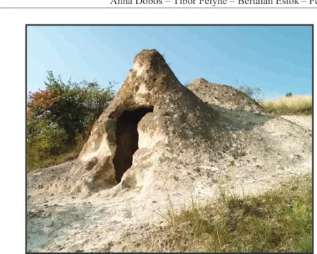
Nowadays, we can observe the development of deep erosional water cuts at some places. The valleys divided into the rhyolite surfaces have formed an ero- sional inselberg. They have excavated the slopes where the physical and chemi- cal weathering, the deflation, mass movements and the sheet wash have created characteristic cones in the Bükk Foreland called "hive stones" (Fig. 4.) (MARTONNÉ ERDŐS,1972B;HEVESI,1978;BORSOS,1991;BARÁZ,2000).
66 Anna Dobos – Tibor Pelyhe – Bertalan Estók– Péter Antal
Fig. 4. The “hive-stones” as characteristic morphological and cultural elements in the Bükk Foreland are situated in the Maklányi valley (Dobos, A.)
The Pleistocene fluvial terraces that appeared in different levels above the al- luvium verify the changeable efficiency and transportation competency of the Maklányi creek (Fig. 5.).
During the glacial periods, the frost weathering was very intensive. The out- crops of the rhyolites and welded ignimbrites froze, the finer sediments disinte- grated into smaller grains, so the rate of finer sand grains increased. The fine, plastic sediments filled up with water have redeposited slopeward above the permafrost layer. The whole surface was eroded by slow gelisolifluction. There are derasional valleys, dells and erosional-derasional valleys deepening into the slopes.
The gelisolifluction, the congelisolifluction and the pluvionivation were the major causes of the planation of the surface. During the cold glacial periods, the deflation formed “hive stones” and higher pediment surfaces.
The alluvium of the Maklányi creek of 100–200 metre width varied with some back marsh formed during the Holocene. The slopes being steeper than 15º are eroded intensively, so this area can be categorised as strongly endangered by soil erosion.
The most important interest of this river basin is an antropogenic formation, which can be preserved by human interference only. This is the travertine mound. In 1961, during the exploration of petroleum fields around Demjén the No. De-42. exploration well was deepened here. Oil was not found here, but the thermal water sprang from the well (No. K-4(9-2). thermal well) to the surface.
Since then thermal water of 8 000 000 m3 has broken out into the surface, calcite
of 1000 m3 has segregated and a travertine mound of 2500 m2 has been formed.
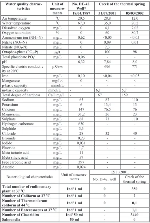
The water spouting from the well contains sodium, sulphur, and calcium- magnesium hydrogen carbonate and a number of other valuable components (Table 1.). Its temperature is 67Cº, it can be categorised as medicinal, fossil (20 000 year old), deep karstic water.
Fig.5. Geomorphological map of the study area (Dobos, A. – Pelyhe, T. – Estók, B.
– Antal, P. 2003)
Because of the high carbon dioxide, the pH of the water is (between 6,3–6,7) mildly acidic, containing lots of calcium in the form of calcium hydrogen carbonate. As consequence of carbon dioxide escape from the flowing water, and the decrease of water temperature, the amount of dissolved calcium ions also diminishes. This causes the condensation of calcium around the points of effluence, and during its accumulation it forms varied tetaratas, terraces and basins (Fig. 6.). The permanent water supply is the guarantee for further evolution of the travertine mound. The eastern part of the travertine mound develops today, calcium layers accumulate in some millimetre thickness onto each other, creating a wavy surface and some centimetre or decimetre wide rimstone pools. The permanent water cover has ceased in the western side of the travertine mound, so that former micro-landforms have eroded, the stone has lost its white colour, it has become grey coloured and dried (Fig. 7.). The insolation weathering processes, the deflation, the frost weathering, the sheet wash and the erosion from human activity have contributed to the destroying of landforms.
The vegetation has already occupied the devastated territories at some places.
68 Anna Dobos – Tibor Pelyhe – Bertalan Estók– Péter Antal
Fig.6. The travertine mound with beautiful varied tetaratas, terraces and basins. The permanent water supply is the guarantee for the further evolution of the rimstones at the
eastern part (Dobos, A.)
Fig.7. The permanent water cover has finished at the western side of the travertine mound, so that former micro landforms have eroded, the stone has lost its white colour,
it has got grey coloured and dried (Dobos, A.)
The travertine mound as a new ecological biotop
The travertine mound in its environment is not only a foreign, individual element from a morphological point of view, but as a new biotop its ecological potential creates favourable conditions for the appearance of new valuable spe- cies. Cianobacteria (Thiobacillus sp.) oxidizing reduced sulphurous compounds are only able to live next to the thermal well, because the water temperature is 67oC. Their chemolitotroph activities are indicated with yellow, downy, filamentous segregations (Fig. 8.). Moving away from the source of the thermal water, Oscillatoria spp. and Lyngbia spp. appear in the water of 50oC, they form dense, green, dark green parallel thallus.
The rimstone pool, the travertine terraces and their microvegetation are recent representative elements of the fossil thermal micro-communities. A hydrogeological formation like this is the travertine mound of the Pamukkale in West Turkey. The water of thermal wells flows through swimming pools as a lukewarm small creek, first crossing an area characterised with reed and bulrush (Typha latifolia/angustifolia), then through a willow wood (Salix sp.), and after reaching the asphalt road, it enters the Laskó stream. The length of the creek from the spring is about 950 metres.
The thermal spring and created travertine mound are valuable biotops, it is confirmed with the result of algological investigations too. MILINKI & ESTÓK
dealt with the floristic investigation of algae living next to the source of springs in 1998. We have complemented their results since 1999 with new floristic and hydrochemical data gathered from the lukewarm middle part of the thermal creek (Table 1.). The Potamogeton crispus L. and Vallisneria spiralis L. form clear, individual substances at some places. Beside these species being the most frequent, Zannichellia palustris L., Sium erectum Huds. and Reynoutria sachalinensis (Schm.) Nakai can appear here. This phase of the creek showed more varied contents of alga flora because the upper part of the creek is bordered with dense vegetation cover (Phragmites australis, Typha sp.).
In periphiton samples, Diatomas: Achnanthes spp., Cocconeis placentula Ehrb., Cymatopleura elliptica (Bréb.) W. Smith, Cymatopleura solea (Bréb.) W.
Smith, Fragilaria ulna (Nitzsch.) Lange-Bertalot, Gomphonema truncatum Ehrb., Gyrosigma acuminatum (Kütz.) Rabh., Hantzschia amphyoxis (Ehrb.) Grun., Melosira varians Agardh, Nitzschia spp., Nitzschia linearis W. Sm., Nitzschia sigmoidea (Nitzsch.) W. Smith, Rhoicosphaenia abbreviata (Agardh) Lange-Bertalot, Surirella elegans Ehrb. (Bacillariophyceae) were dominated during winter and early springtime. After getting better conditions of water tem- perature and light relations, the stand of Potamogeton crispus L. and Vallisneria spiralis L. forms dense reed-grass fields in the whole stream channel in spring and summer. Mixed and homogenous stands could be observed. Among them more filiform green algae species, Spirogyra sp., Cladophora sp., Pithophora sp.(Chlorophyta) could be found.
70 Anna Dobos – Tibor Pelyhe – Bertalan Estók– Péter Antal
Fig.8. The characteristic microflora of the travertine mound are cianobacteria (Pelyhe, T.)
Table 1.: Hydrochemical and bacteriological characteristics Water quality charac-
teristics
Unit of measure-
ments
No. DE-42.
Well*
Creek of the thermal spring 18/04/1987 31/07/2001 05/03/2002
Air temperature oC 20,5 28,8 12,0
Water temperature oC 67,0 35,0 20,2
Dissolved oxygen mg/L 0 4,1 7,02
Oxygen saturation % 0 60 80,7
Ammoni-um ion (NH4-N) mg/L 0,62 <0,05 <0,05
Nitrite (NO2-N) mg/L 0 0,09 0,01
Nitrate (NO3-N) mg/L 0 2,3
Ortophos-phate (PO4-P) g/L - 100 98
Total phosphate PO43- mg/L 0,06 - -
pH 6,32 7,84 8,0
Specific electric conductiv- ity at 20ºC
S/cm - 696 771
Iron mg/L 0,10 <0,04 <0,05
Manganese mg/L< 0 < <
p-basic capacity mmol/L - - -
m-basic capacity mmol/L - 6,1 5,7
Total degree of hardness CaO mg/L - 167 159
Sodium mg/L 65 87 110
Potassium mg/L 6 13,4 13
Calcium mg/L 147 76,5 76
Magnesium mg/L 31,2 26 23
Sulphate mg/L 68 73 110
Hydrogen carbonate mg/L 630 - -
Sulphide mg/L 3,3 - -
Chloride mg/L 28 32 40
Bromide mg/L 0,23 - -
Iodide mg/L 0,031 - -
Fluoride mg/L 1,7 - -
Meta tartaric acid mg/L 11
Meta silicic acid mg/L 57 - -
Free carbonic acid mg/L 397 - -
Arsenic mg/L 0,024 - -
Bacteriological characteristics Unit of measure- ments
12/11/2001.
No. D-42. well Creek of the thermal spring Total number of rudimentary
plant at 37 oC Ind/ 1 ml 0 350
Number of Coliform at 37 oC Ind/ 1 ml 0 2
Number of Thermotolerant
coliform at 44 oC Ind/ 1 ml 0 0,1
Number of Enterosoccus at 37 oC Ind/ 1 ml - 1,1
Number of Clostridim Ind/ 50 ml - 3440
Salmonella 50 ml - 0
* Investigation results of the National Institute of Public Health (OKI), 1987.
72 Anna Dobos – Tibor Pelyhe – Bertalan Estók– Péter Antal The Euglena klebsii (Lemm.) Mainx., Euglena spirogyra Ehrb., Phacus cau- datus Hübner (Euglenophyta) and Closterium moniliferum Bory Ehrb., Cosmar- ium spp. could be detected in entangled, some metre length bundle of yarn in case of thread-like algae. There is a concrete basin near the road, the creek flows through it towards the Laskó stream. In this concrete basin, the trichomata of Oedogonium sp. (Chlorophyta) sometimes composes “collar-like fur” in leaves of Vallisneria spiralis L.. Less algae species live in the creek in summer, be- cause the water temperature is above 30oC. The Fragilaria ulna, Cocconeis pla- centula, Melosira varians, Nitzschia sigmoidea species can be found here for the whole of the year.
We identified a special and rare red algae species, the Thorea ramosissima Bory (Rhodophyta), in the creek of the thermal spring in 1999 (PELYHE &
BALOGH, 2000, Fig. 9.). Its occurrence in Hungary has been registered by FILARSZKY (1930), UHERKOVICH (1957) and TAMÁS (1958, 1959) earlier.
The Thorea ramosissima appears periodically in the lukewarm, middle phase of the creek during the year. It can be observed in late autumn or especially dur- ing the winter-spring time, it sometimes appears in masses. It could be shown in the creek from December in 1999 to the end of May in 2000. It could not regis- tered at all during the summer. During the mentioned period, the Diatomas growed along an approx. 30-metre length and more than 60 smaller and bigger individual thallus could be seen here, the longest trichomata reached 2 meter length. The Thorea inserts into solid surfaces and rocks in the water, but some of them appear in the mud. The young individuals being some centimetre in diame- ter became fixed in the surface of the water-plant.
Fig.9. The parts of diverging thallus in the case of Thorea ramosissima Bory (Rhodophyta)(Pelyhe, T.) (Pelyhe, T.)
The red algae generally appear in an environment where the water tempera- ture is between 14-25 oC and the rate of the dissolved oxygen is 5,46-7,32 mg/l (72-84%). The results of pH-measurements (7,9-8,1) and the measurements of the specific electric conductivity at 20 ºC (750-825 S/cm) were stable, only some changes could be shown. We have only some information about its hy- droecological requirements and the reason of its sporadic spreading. These spe- cies prefer territories where the climatic and hydroclimatic conditions are bal- anced. The water quality of the creek could be classified into the first and the second categories (excellent and good category) according to the Hungarian Standard on the Quality of surface water, quality characteristics and classifica- tion No. MSZ 12749: 1993.
Land use changes, medical and recreational developmental trends
From the ecological point of view, the river basin of the Maklányi valley formed a unique landscape with its interesting geological, morphological (Mak- lányi hill - fluvial inselberg, “hive stones”, valuable geological sequences), cul- tural (“hive-stones”, Maklányi castle), botanical, zoological and landscape val- ues before the drilling of the hydrocarbon exploration well.
The travertine mound evolved in consequence of the human processes is a new morphological element of the landscape. The utilisation of the thermal wa- ter creating the largest live travertine mound in Central Europe began in the 1960's. The co-operative farm in Egerszalók used the water for heating green houses after 1961. The salt segregation has caulked the conduits soon, so they were picked up. After the suspension of economic utilisation, there was a free beach until 1990. The local government in Egerszalók has used this territory with yearly renewing rental treaty since 1990. The thermal bath and its surround- ings are private property at present, so the bath can be visited after paying an admission fee only.
For years, the main aim has been to realise an integrated land use investment here, by building a medical hotel, thermal bath and lake. The plans for this de- velopment have not taken into consideration botanical and zoological values of this area, and the hydrogeological and geological values examined from a nature and landscape protection aspect have got special attention in only one of the plans.
The territory next to the travertine mound and the Maklányi valley has been uncultivated areas for years, only the middle part of the valley is under cultiva- tion today. This area being in seminatural conditions can lose its original func- tion of an ecological channel, because of the development. This medical and recreational investment completed with infrastructural developments stretches into the whole territory of the river basin, but the lower part of the Maklányi valley is getting into prominently endangered position (Fig. 10.).
74 Anna Dobos – Tibor Pelyhe – Bertalan Estók– Péter Antal
Fig.10. The development plan for the building investment (based on Eger, Architectural Office, 2000).
Summary
The expectable drastic changes in land use deserve special attention in our study area, because the nature protection of the travertine mound was already launched by OKHT in 1984. The legal protection was not materialised, because there were not enough financial benefits and the protection proceedings were stumbled. The local government fenced off the travertine mound in 1994, in that way it secured the protection status of the object and the inner margin of its groundwater protection area temporarily. The thermal well itself is not under the official protection, so its economic utilisation offers unlimited possibilities.
References
Balogh, K. (1964): A Bükk hegység földtani képződményei, MÁFI Évkönyve, XLVII.
kötet, 2. füzet, Budapest, pp. 1–719.
Baráz, Cs. (2000): Kaptárkövek. Szakrális kőemlékek a Bükkalján, Eger, pp. 1–68.
Borsos, B. (1991): A bükkaljai kaptárkövek földtani és felszínalaktani vizsgálata, Föld- rajzi Közlemények, CXV. (XXXIX.) kötet., 3–4., Budapest, pp. 121–137.
Császár, G. (1997): Basic litostratigraphic units of Hungary, MÁFI, Budapest, pp. 1–
114.
Dobos, A. (2000): A Hór-völgy fejlődéstörténete és természetvédelmi szempontú tájér- tékelése, Doktori (PhD) értekezés, Debreceni Egyetem Természettudományi Kar, Debrecen, pp. 1–119.
Dobos, A. (2002): A Bükkalja II. Felszínalaktani leírás, in: Baráz, Cs. (szerk.): A Bükki Nemzeti Park, Hegyek, erdők, emberek. Bükki Nemzeti Park Igazgatóság, Eger, pp. 217–228.
Dobos, A. – Pelyhe, T. – Estók, B. – Antal, P. (2003): The travertine mound as a special hydrogeological value and its surroundings in Egerszalók before the building investment - Carpatho-Balkan Workshop on Environmental change impacts in the Carpatho-Balkan Region, Paklenica-Starigrad, 23–27. September 2002, Croatia. – poszter
Filarszky, N. (1930): A budai hőforrások nyílt vizeinek Chara-féléi és néhány más érde- kesebb, ritkább algafaja, Math. Természettud. Értesítő 47., Budapest, pp. 652–
676.
Hámor, G. (1996): Gyulakeszi Riolittifa Formáció, in: Gyalog L. (szerk.): A földtani térképek jelkulcsa és a rétegtani egységek rövid leírása, MÁFI Alkalmi Kiadvá- nya, Budapest, pp. 187.
Hevesi, A. (1978): A Bükk szerkezet és felszínfejlődésének vázlata. (An outline of structural and geomorphological development of Bükk Mts.), Földrajzi Értesítő, XXVII. évf., Budapest, pp. 169–198.
Hevesi, A. (1986): A Bükk hegység felszínfejlődése és karsztja, Kandidátusi Értekezés, Budapest, pp. 1–187.
Hevesi, A. (1990): A Bükk szerkezet- és felszínfejlődése, különös tekintettel a karszto- sodásra, MFT 43. Vándorgyűlése, Miskolc, pp. 1–67.
Martonné Erdős, K. (1972a): A Déli-Bükk középső részének felszín- és völgyfejlődési problémái, Doktori értekezés, I–II., Debrecen.
Martonné Erdős, K. (1972b): Az Alsó-Bükk kaptárkövei, Studium III. A KLTE Tudo- mányos Diákköre kiadványai, Debrecen, pp. 109–126.
Martonné Erdős, K. (2000): A Bükkvidék, Kézirat, Debrecen, pp. 1–39.
Milinki, É., Estók, B. (1998): Az egerszalók-demjéni hőforrás alga flórájának változásai 1987–1996 között, Acta Academiae Paedagogicae Agriensis Nova Series Tom.
XXII., pp. 73–81.
Magyar Szabványügyi Testület (1994 január): Felszíni vizek minősítése (Quality of surface water, quality characteristics and classification), Magyar Szabvány 12749:1993, Budapest, pp. 1.
Országos Közegészségügyi Intézet Ásvány-gyógyvíz vizsgálati jegyzőkönyve 1987.
Pelyhe, T., Balogh, J. 2000: Thorea ramosissima Bory (Rhodophyta) at Egerszalók, The 11th Hungarian Algological Meeting. Program and Abstract.
Pentelényi, L. (2002): A Bükkalja I. Földtani vázlat. in: Baráz, Cs. (szerk.): A Bükki Nemzeti Park, Hegyek, erdők, emberek. Bükki Nemzeti Park Igazgatóság, Eger, pp. 205–216.
Pinczés, Z. (1956): A Déli Bükk és előterének néhány fejlődéstörténeti problémája, Acta Geogr. Debrecina, Debrecen, 26. pp. 1–12.
Pinczés, Z. (1968): A Bükk-hegység tönk és pediment felszínei, MTA Földrajztudomá- nyi Kutató Intézet, Természetföldrajzi Dokumentáció, 7., Budapest, pp. 32–39.
Pinczés, Z., Martonné Erdős, K., Dobos, A. (1993): Eltérések és hasonlóságok a hegy- lábfelszínek pleisztocén felszínfejlődésében, Földrajzi Közlemények, CXVII.
(XLI.) kötet, 3., Budapest, pp. 149–162.
Póka, T., Zelenka, T., Szakács, A., Seghedi, I., Nagy, G. (1997): Petrology and geochemistry of the Miocene ignimbritic volcanism of the southern foreground of
76 Anna Dobos – Tibor Pelyhe – Bertalan Estók– Péter Antal
the Bükk Mountains, Hungary, Abstract – PANCARDI’97. Kraków – Zakopane, p. 1097.
Szakács, A., Zelenka, T., Márton, E., Pécskay, Z., Póka, T., Seghedi, I. (1997): Miocene acidic explosive volcanism in the Bükk Foreland, Hungary: Identifying eruptive sequences and searching for source locations, Kézirat
Tamás, G. 1958: Beiträge zu der Algenflora des Balaton-sees. I. Steiniges Ufer sandiges, röhricht und künstliches substrat. Annales Institut Biologici (Tihany) Hungaricae Academiae Scientiarum, Tihany. pp. 353–358.
Tamás, G. 1959: Algenflora des Balatonsees 1938–1958 – Ann. Biol. Tihany 26: pp.
349–392.
Uherkovich, G. (1957): Das Leben der Tisza III. Thorea ramosissima Bory (Rhodophyta) aus der Tisza – Acta biol. (Szeged) n. ser. 3: pp. 207–212.