WINDOWS
ON HUNGARIAN GEOGRAPHY
GEOGRAPHICAL RESEARCH INSTITUTE
RCES HUNGARIAN ACADEMY OF SCIENCES
STUDIES IN GEOGRAPHY IN HUNGARY, 29
Geographical Research Institute Research Centre for Earth Sciences
Hungarian Academy of Sciences
Editorial board L. BASSA Z. KERESZTESI
Á. KERTÉSZ F. SCHWEITZER
WINDOWS ON HUNGARIAN GEOGRAPHY
Contribution to the Regional Geographical Conference, Lisbon, Portugal, August 28 - September 3 1998
Edited by LÁSZLÓ BASSA ÁDÁM KERTÉSZ Geographical Research Institute Research Centre for Earth Sciences
Elungarian Academy of Sciences
GEOGRAPHICAL RESEARCH INSTITUTE HAS BUDAPEST 1998
Preparation for printing carried out at the Geographical Research Institute Research Centre for Earth Sciences Hungarian Academy of Sciences (GRI RCES HAS)
Computer typesetting and layout:
ZOLTÁN KERESZTESI, MÁRIA TÁRKÁNYI
Technical editor:
ZOLTÁN KERESZTESI
Technical staff:
MARGIT MOLNÁR, ISTVÁN POÓR
ISBN 963 7395 83 0 HU ISSN 0081-7961
© FERENC SCHWEITZER, director of the GRI RCES HAS, 1998
A ll rights reserved. N o part of this book may be reproduced by any means, transmitted or translated into machine language without the written permission o f the publisher
Published by Geographical Research Institute Research Centre for Earth Sciences Hungarian Academy of Sciences, H-1062 Budapest, Andrássy út 62
Printed in Hungary by EXEON Bt.
C O N T E N T S
PREFACE ... 7
I. GENESIS OF LANDFORMS
PÉCSI, MÁRTON: A model for the geomorphological evolution of the Transdanubian Mountains, Western Hungary ... 9 GÁBRIS, GYULA: Late Glacial and Post Glacial development of drainage network
and the paleohydrology in the Great Hungarian Plain ...23 JUHÁSZ, ÁGOSTON and MAROSI, SÁNDOR: Geomorphic evolution of Lake
Balaton ... 37 VERESS, MÁRTON and PÉNTEK, KÁLMÁN: Modelling of karst surface evolution:
Quantitative description of surface vertical karstification ... 53
II. HUMAN IMPACT, GLOBAL CHANGE, ENVIRONMENTAL ISSUES SCHWEITZER, FERENC and TINER, TIBOR: The role of geography in site
selection ... 71 GÁBOR MEZŐSI and GÁBOR DORMÁNY: Regional differences of forest fire
hazard in the test area of the Mátra Mountains ... 85 KERTÉSZ, ÁDÁM: Aridification - climate change and its consequences in Hungary 91 KERÉNYI, ATTILA, KISS, GÁBOR, and SZABÓ, GYÖRGY: Geography and envi
ronmental protection ... 99
III. A THEORETICAL ESSAY
TÓTH, JÓZSEF: Geography science: An old-new discipline ... 111
IV. HISTORICAL GEOGRAPHY
FRISNYÁK, SÁNDOR: The economic geography of Hungary in the age of the
Árpáds ...117 BECSEI, JÓZSEF: The Hungarian system of tanyas ... 131 KOCSIS, KÁROLY: Contribution to the geography of religions in the Carpatho-
Pannonian area ... 149
V. SOCIO-ECONOMIC TRANSITION: SPATIAL ASPECTS
KOVÁCS, ZOLTÁN and DÖVÉNYI, ZOLTÁN: Urbanisation and urban develop
ment in Hungary ... 157 BARTA, GYÖRGYI: Future paths in industry: de-industrialisation or re-industriali
sation in Budapest? ... 175 RECHNITZER, JÁNOS: Allocation of foreign investments in the Transdanubian Re
gion ... 185 TÍMÁR, JUDIT and VELKEY, GÁBOR: The question marks of the relatively
favourable rate of female unemployment in Hungary ... 199
PREFACE
It was almost 30 years ago, in 1971, when the Regional Conference of the International Geographical Union (IGU) was held at Budapest, that a volume of studies providing a brief account of geography of the organising country and the contemporary results of Hungarian research was published. More than ten years later a massive volume (Geographical Essays in Hungary, 1984) reported on the state-of-the-art of Hungarian geography, at that time as a contribution to the 25th IGU Congress in Paris- Alpes. Six years ago, a volume in the series Studies in Geography in Hungary was devoted to the 27lh IGU Congress held in Washington D.C., USA. Now this is the fourth occasion that a set of papers is dedicated to a similar event, in our case to the Regional Geographical Conference to be organised at Lisbon, Portugal between August 28 and 3 Septemberl998.
Over the past 27 years fundamental changes have occurred in the world in general and in the geographical domain in particular. As far as the former are concerned the dramatic socio-economic transformation in the countries of Central and Eastern Europe has been focal for Hungary involving in the last decade spatial changes, the analysis and evaluation of which has been a great challenge also to the geographical science. The emergence of the information society and the processes of globalisation are further trends to have made a profound impact on geographical thought. At the same time technological progress (e.g. the improvement of dating methods, remote sensing devices, computerisation and the resulting expansion of GIS) has provided robust tools for the geosciences.
The first chapter deals with the geomorphic evolution of different regions and environments. M. Pécsi's contribution is intended to set up a polygenetic model of geomorphological surface evolution of the Transdanubian Mountains, in the course of which morphostructures were affected by plate tectonic events. Gy. Gábris attributes the Late Glacial and Post Glacial development of the drainage network in the Great Hungarian Plain to tectonic effects and climatic fluctuations; downcutting, upfilling and transitional phases were established through the analysis of environmental changes. A.
Juhász and S. Marosi gave an interpretation of the Balaton basin as having formed as a result of a stadial (spatial and temporal) subsidence. The last paper of the chapter offers a specific karst surface evolution model (of vertical karstification) by M. Veress and K.
Péntek.
The second chapter starts with an article (authors F. Schweitzer and T. Tiner) summarising geographical contibutions to the site selection for large-scale industrial and energetical projects, comprising engineering-geomorphological and geoecological mapping, environmental impact assessment, and socio-economic investigations with an emphasis on case studies. Human impact is also the subject of the following paper by G.
Mezősi and G. Dormány dealing with a survey of forest fire hazard in a test area using remote sensing and GIS methods of investigation. Á. Kertész reports on the results of an
aridification research programme (in order to reveal quantitatively global climate change, subsidence of groundwater table, changes in natural vegetation and soil dynamics) launched on the Danube-Tisza Interfluve (the driest region of the country), within the framework of the MEDALUS II project. A theoretical approach to environmental issues and the results of applied geographical studies within a sample area form the topics of the contribution by A. Kerényi, G. Kiss and Gy. Szabó focusing on the evaluation of landforms and soils serving environmental protection.
In his theoretical essay J. Tóth deals with the taxonomic position of geography and with the inner structure of geography science.
The fourth chapter is devoted to the historical geographical domain. A paper by S. Frisnyák on the economic geography of Hungary in the age of the Árpád dynasty (11th through 13,h centuries) presents spatial aspects, i.e. settlement structure and economy pattern (animal breeding, crop farming, mining and craftsmanship, transport and trade) of this particular period. J. Becsei's article not only offers an historical outline of the emergence and development of the tanya system in Hungary but also provides an insight in the recent and present-day modifications of the scattered farmsteads induced by the latest socio-economic changes. A paper by K. Kocsis reflects a revival of the geography of religions in the Carpatho-Pannonian area; in addition to a concise historical analysis there is a description furnished with a map of up-to-date spatial distribution of religions in this vast region.
The final chapter is about the spatial aspects of a period o f socio-economic transition having started with the 1990s. Z. Kovács and Z. Dövényi, in their paper depict the situation of the Hungarian urban system on the eve of the socio-economic transformation and the resulting post-socialist urban transition under the impact of the economic crisis and restructuring in the individual cities. Also the process of restructuring is a topic tackled in the paper by Gy. Barta suggesting alternative views on the present and future industrial development of Budapest taking into account the ongoing investment, the transformation of structure and organisational forms, and technology transfer. Successful regions in the northern part of Transdanubia are dealt with in the contribution by J. Rechnitzer with a special reference to the distribution of foreign investment by counties and economic sectors, highlighting regional disparities, and with a contemplation about prospects for the future. Female unemployment as an outcome of the recent economic transformation is discussed in a paper by J. Tímár and G. Velkey from a methodological viewpoint.
The size of the present volume did not allow a thematical completeness. It should be viewed as an attempt to give the reader an impression of the trends within the Hungarian geographical research at the end of the century and millennium. Hence the title: Windows on Hungarian Geography.
The publication of this volume was realised by the financial assistance o f the Hungarian National Research Fund (OTKA), and this support is gratefully acknow
ledged.
The Editors
L. Bassa-A. Kertész (eds): Windows on Hungarian Geography
Studies in Geography in Hungary 28, Geographical Research Inst. HAS, Budapest 1998, pp. 9-22
A MODEL FOR THE GEOMORPHOLOGICAL EVOLUTION OF THE TRANSDANUBIAN MOUNTAINS, WESTERN HUNGARY
MÁRTON PÉCSI
Geographical Research Institute, Research Centre fo r Earth Sciences Hungarian Academy o f Sciences
H-1388 Budapest, P f 64
INTRODUCTION
The term geomorphological surfaces denotes plains and gentle slopes, which are the products of erosion, of accumulation or of their combination, under the influence of tectonic processes. Their formation may be dated from their correlative sediments or by other methods.
For the timing of successive formation of landforms, ie. for a reconstruction o f the denudational chronology, an interpretation of the different geomorphological sur
faces is needed. Several models were proposed for the development of erosional sur
faces (landforms) on great continental morphostructures. Some of these have become classic (Davis, W. M. 1906, 1922; Penck, W. 1924; King, L. C. 1949, 1962; Büdel, J.
1957 and his followers, Bulla, B. 1958; Bremer, H. 1986).
1. According to Davis, the peneplain (ultimate peneplain) is the final product of fluvial erosion on different humid regions. The almost plane surface is the penultimate phase of the planation at the base level.
2. Penck's Primärrumpf (primary peneplain) is a plain surface just emerged above the sea level. Piedmonttreppen (piedmont benchlands) are explained by fluvial erosion and retreat of valley sides. Erosional surfaces on slowly but uniformly elevating morphostructures may be explained this way.
3. According to King, pediplanation also takes place by the retreat of slopes on slowly but continuously elevating terrains, especially under semiarid climates, where the rate of the mechanical weathering exceeds that of the chemical one. Retreat of slopes results in a gradual surface lowering and pediplain formation. According to King, pe
diplanation is the most widespread process reducing relief, this way it replaces Davis' peneplain theory.
4. Büdel proposes that the double etchplain (doppelte Einebnungsfläche) is an erosion surface created by intensive lateritie deep weathering and strong washdown (stripping) of the thick weathered rock under a seasonal dry and wet tropical climate.
5. A pediment is a gentle erosional foothill slope in front of a steep mountain slope, generally formed of hard rock. Pedimentation is admitted to be the most general
erosional, planation process. McGee, W. J. (1897) believes that a river, on leaving a mountain, deposits most of its load, while the rest of the sediment transported causes lateral planation (corrasion). The pediment is covered by a thin layer of sediment, de
posited by sheetwash or by small rivers under a semiarid climate.
Several researchers adhere to the above models for the origin of surfaces o f planation, while others criticise or modify them. In one respect these models are uni
form, they suppose that the studied surfaces were formed during long geological times, when uplift was slow, continuous or periodical. It is generally admitted that the highest situated geomorphological surfaces are the oldest, the lower ones are ever younger. Such presumptions might only be valid for a part of the cases and for some geological times.
Presumably the planation surfaces (models 1 to 5), explained by different proc
esses, might be attributed to effects of as many different geographical environments. If this is true, each of these models and conceptions generally represent genetically and climatologically different morphofacies rather than one single, global type of surface. It must be mentioned that these early models of planation surfaces were based on fixist tectonism.
In this presentation it is intended to introduce a poly genetic model o f geomor
phological surface evolution, through processes acting on different morphostructures affected by plate tectonic events, particularly in orogenic belts. The units studied were horizontally displaced over great distances, tectonically dismembered, recurrently up
lifted and subsided, thus the planation surface became repeatedly buried, elevated and exhumed again (Pécsi, M. 1970a,b).
Polygenetic morphostructures with planation surfaces, which were shaped un
der the influence of alternating erosional and depositional processes of long duration, were removed from their original place and carried over long distances, passing under various climatic belts. This way units of most different genesis might have come in each other's proximity.
The tectonic and geomorphic history of the Transdanubian Mountains (western Hungary) was used as a model for the evolution of such polygenetic planation geomor
phological surfaces. Geological and geomorphological studies of the last half century served as a basis of a new geomorphological evolutionary model, differing from the previously mentioned ones (Pécsi, M. 1968, 1975, 1993; Székely, A. 1972).
DISCUSSION
The Transdanubian Mountains (TM) is a low range of slightly folded structure, built mainly of Mesozoic and Paleogene carbonates (limestone and dolomite), affected by overthrusts and faults. Horst and graben structures are common, delimited by mainly northeast-southwest and northwest-southeast running structural lines. In the southern
NW SE
-2000
- 3 0 0 0
- 4 0 0 0
- 5 0 0 0
Dudar Gaja öregfutóné
Bakonytamási Csesznek . Berhida
Tét—2
Fig. 1. Profile across the Bakony Mountains (after WEIN, GY. and PÉCSI, M. ). - 1 = Holocene-PIeistocene fluvial sand and gravel, alluvial plain; 2 = Upper Pannonian sand and clay; 3 = Lower Pannonian (Miocene) claymarls; 4 = Lower Miocene-Upper Oligocene gravel and sand (in the Dudar Basin); 5 = Eocene coal seams and carbonate rocks; 6 = Lower Cretaceous (Aptian, Albian and Cenomanian) limestones and calcareous marls; 7 = Bauxite and related formations; 8 = Jurassic limestones; 9 = Upper Triassic dolomites and limestones; 10 = Middle Triassic limestone;
11 = Lower Triassic siltstone, marl and limestone; 12 = Permian sandtones and conglomerates; 13 = Upper Carboniferous granite porphyry; 14 = Lower Carboniferous conglomerate and shale; 15 = Silurian - Devonian phyllite and marble; t = uplifted remnant o f tropical etchplain; ft = buried etchplain; e = exhumed etchplain, locally covered with Miocene gravel; pe = mountain margin benchland; I12 = Pannonian marine terrace; hi = piedmont surface (pediment); g = Pleistocene surface formed on moderately consolidated sediment (glacis); k = remodelled tropical etchplain in threshold position; Tét-2 = prospect drilling; S-D = Silurian - Devonian; Ti, T2, T3 = Lower, Middle, Upper Triassic; M = Miocene; Pli = Lower Pannonian (Upper Miocene); P l2 = Upper Pannonian (Upper Miocene)
foreland a thick Paleozoic sequence of south Alpine affinities underlies the similarly thick Mesozoic strata (Figure 1).
Comparative structural investigations proved that the TM was a part of the car
bonate platform formed at the northern margin of the African plate in the southern Tethys, during the Triassic. During the rifting and subsequent convergence of the Tethys this unit was overthrusted on an oceanic crust fragment, the Penninic unit. The TM, as a part of a microcontinent, was subsequently carried into the southern Alpine area, where
from, in late Cretaceous/Paleogene times it was horizontally shifted into the Carpathian basin (Horváth, F. 1974; Géczy, B. 1974; Wein, Gy. 1977, 1978; Balla, Z. 1988, Hámor, G. 1989; Fülöp, J. 1989; Stegena, L. and Horváth, F. 1978).
During the late Triassic and early Jurassic the low and extended carbonate platform of the TM was cut into a hörst and graben structure. In the grabens the sedi
mentation went on during the Jurassic and early Cretaceous. On the elevated parts a long lasting continental downwearing went on during the Jurassic and Cretaceous. The upper Triassic carbonates were affected by tropical karstification, accompanied by bauxite formation. Cockpits and tower karst may have been formed under tropical savanna cli
mate with humid and dry seasons, simultaneously with bauxite formation. The initial sediments of the bauxite formation were resedimented from siliciclastic areas by sheet wash and by small rivers. Lateritification was simultaneous with karstic planation. Wit
nesses of this marked tropical karst planation were buried and preserved by lower Cre
taceous (Albian), upper Cretaceous, and, locally, Paleogene sediments in the TM.
Buried surfaces of karstic planation may be found between horsts, forelands and on horsts, buried with Cretaceous or Tertiary strata (Figures 2 and 3).
WNW E 4 °
ESE
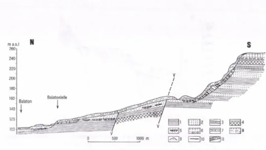
Fig. 2. Geomorphological surfaces in the Vértes Mountains in Hungary. - A = exhumed hörst in sum
mit position, a remnant o f slightly remodelled Creaceous etchplain; C = hörst in foothill position: C] = totally buried; C3 = totally exhumed; D = buried surface o f etchplain in intermontane graben position;
Di = intermontane graben, filled with molasse and alluvial fans; E = glacis d’erosion with terraces; Ei = rock pediment and glacis d ’erosion; F = remnants o f marine terrace (Upper Pannonian); G = submon
tane basin with river and glacis terraces; t i- U = fluvial terraces; mti = marine terrace; 1 = alluvium and m eadow soil; 2 = alluvial fan; 3 = loess and loess-like sediments; 4 = Pannonian sandy and silty for
mations; 5 = Sarmatian formations; 6 = M iocene gravel and sand; 7 = Oligocene sand and clay forma
tions; 7a = Oligocene lignite; 8 = Eocene limestone; 9 = Cretaceous bauxite; 10 = Triassic dolomite and limestone; 11 = granite; 12 = Carboniferous metamorphic rocks
The tropical karst planation surface of the TM was slightly remodelled be
tween the late Cretaceous and middle Eocene (Laramian tectonic phase?). On horsts summits it was well preserved, but on the margins pediments were formed due to early Eocene subarid coarse clast production. Dolomite karst towers and bauxites, if not bur
ied, were eroded or resedimented.
During middle and late Eocene the area of the TM became an archipelago.
Most of its territory subsided continuously, but not uniformly. The sea inundated the low horsts and intramontane basins. Bauxite bearing karstic surfaces of etchplanation were often buried during the Eocene.
Bauxite lenses in sinkholes, capped with Eocene layers, are often interpreted as a result of a continuation of tower-karst plain formation and bauxite genesis in the first part of the Eocene (Bárdossy, Gy. 1977; Mindszenty, A. et al. 1984). This would mean that such bauxites are not merely products of Eocene redeposition of earlier deposits.
We think, however, that early Eocene conditions characterised by dolomite breccia formation were not favourable for bauxite genesis and tower karst evolution. Under a subaridic climate predominantly coarse elastics were formed and transported by ephem
eral water-courses and pedimentation prevailed (Pécsi, M. 1963, 1970b).
From the Eocene-Oligocene boundary the TM was uplifted and the previously submerged and buried parts were eroded. Some segments or entire horsts were exhumed
Budakeszi-medence Budakeszi-erdő Szabadság-hegy Diós-árok Istenhegy Martinovics-hegy
0 1 2 km
»I I' S zín ez Pizh .'r.h »1 fcj±ül‘ 0zf-~ -b °zl - - l6 ‘01lllllll/F "oh • c WllliHI»
bE I -r )l0 1 1*1 |n aTNÍ 1 I 1 I 1)2 tTh L) -Mn °T, t i 1 l |u <Tk |i f i f.|l5 RTk *TI K/irtr? 2ll Itr/rJw Fig. 3. Alternating erosional/accumulational planation surfaces of the Buda Highland in Hungary (after Pécsi, M. and Wein, Gy.). - A = exhumed, planated surface in uplifted pediment position; B = buried Cretaceous etchplain in uplifted position; C = surfaces o f planation in uplifted pediment position: 1, totally buried, 2, partially exhumed, 3, totally exhumed; D = buried surfaces o f planation in graben position; E = glacis d’erosion; 1 = Pleistocene loess and wind blown sand; 2 = Pleistocene travertine; 3
= Pliocene sand, clay travertine; 4 = Sarmatian conglomerate and limestone; 5 = Upper Oligocene sandy clay, silt; 6 = Middle Oligocene clay; 7 = Lower Oligocene marl; 8 = Lower Oligocene sand- tone; 9 = Eocene formations; 10 = Preeocene etchplain, Preeocene etchplain, Eocene reworked bauxite and conglomerate; 11 = Eocene acid dyke; 12 = Upper Triassic Dachstein Limestone; 13 = Upper Triassic Hauptdolomite; 14 = Upper Triassic coarse dolomite; 15 = Upper Triassic cherty dolomite; 16
= Upper Triassic marl, limestone dolomite; 17 = Middle Triassic pink dolomite; 18 = Middle Triassic Di'pfopora-bearine dolomite
and subsequently pedimented. There are several horsts, where bauxite and tropical tower-karstic surfaces were preserved under a thick Eocene limestone cover (Figure 3).
During the second part of the Oligocene the horizontal shift of the TM was go
ing on, its subsidence was highly differentiated. This is supported by the fact that sedi
ments of differing facies (coarse clasts, gravel, sand and clay) were deposited on the surface of the TM, which moved eastward. The sediments originating from some higher, crystalline mountains in the vicinity.
During the Miocene (from 24 to 5.5 Ma) the relief of the TM and its close envi
rons changed repeatedly and fundamentally in consequent tectogenetic phases, horizon
tal and vertical displacements, subduction, a powerful volcanic activity, partial trans
gressions and regressions. These processes resulted in a geomorphological inversion at the end of the Miocene. The TM were uplifted to a moderate altitude, but definitely over its surroundings, for the first time during the Tertiary. On its sinking north-eastern part andesitic volcanoes erupted during the middle Miocene (15-14 Ma BP). Deposition of terrestrial gravel and other elastics continued on the margins of planation surfaces, with some interruptions.
On some low-lying Mesozoic horsts and in intramountain small basins the rem
nants of etchplains were newly but incompletely buried during the late Tertiary. On tectonically uplifting horsts the old tropical karsts were exhumed and remodelled.
During the late Miocene by the Sarmatian and Pannonian transgression (ca 13 to 11 Ma BP) the TM subsided again, but adjacent regions to the south and north (Little Plain and Transdanubian Hills) were subsided at higher rate thus the TM remained a mainland or an archipelago (Jámbor, A. 1989). Some mountain groups, marginal horsts and intramountain grabens were buried, in fact, fo r the third or fourth time during the Tertiary, under Pannonian sands and freshwater limestones, at an elevation close to the base level.
During the late Miocene the majority of horsts in the TM were at an elevation of 100 to 200 m above the Pannonian lake level. Due to the uplift and climate turning from subhumid to semiarid, pedimentation processes intensified along the margins of horsts for short periods (e.g. at the Sarmatian-Pannonian boundary). Morphological evidence of deflation are wind-abraded and polished rocks, sand blankets, iron- varnished pebbles, iron-oxide concretions, meridional valleys and ridges (yardangs), which were formed during the late Miocene.
Horsts uplifted during such periods and especially at the end of the Pannonian were stripped off a cover of Oligocene and Miocene clastic sediments. In some spots marine shelves were formed, preserved by travertine deposits (Figure 4). The horizontal displacement of the TM into its recent structural position lasted from the end of the Oligocene (Báldi, T. 1982; Hámor G. 1989) to the middle Miocene (12-10 Ma BP.
Balla, Z. 1988, Kázmér, M. 1984), when the subsidence of the Pannonian basin started.
From about this time tectogenetic processes caused repeated subsidence and uplift of the hörst groups and grabens of the TM, upward movements dominated. This resulted in formation of marine terraces, deltaic deposits and erosional foothill slopes on marginal parts of the mountains.
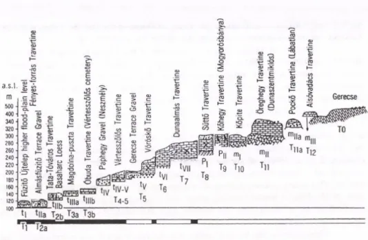
Fig. 4 Geomorphological surfaces and travertine horizons in the Gerecse foreland (Pécsi, M., Scheuer, Gy. and Schw eitzer F. 1988). - t|-tvii = river terraces usually covered by travertines (T1- T7) and loess;
P1-P11 = Pliocene pediment surfaces covered by travertines (Tg-T?); mi-mvn = Upper Pannonian (Upper Miocene) raised beaches covered by travertines (T10- T12); To- = Paleogene-Neogene planation surface sculptured by O ligocene-M iocene pedimentation with sporadic gravels.
Paleomagnetic polarity according to Pécsi, M. and Pevzner, M. A.
At the beginning o f the Pliocene (5.4 Ma BP) uplift intensified. From the late Miocene on the climate shifted to a subhumid one. In consequence, a considerable part of the Tertiary siliciclastic, gravel, sand cover of the TM was eroded and redeposited on the forelands. On the unconsolidated molasse like sediments a broad hillfoot surface took shape, while in the forelands wide alluvial fans were deposited. The hot subarid climate was interrupted several times and followed by subhumid warm periods. This increasingly favoured the cyclic development of red and variegated clays.
Neither the considerable time span of variegated and red clay formation nor the cause of the subhumid climate has been investigated in details. The effect of these events on the morphological evolution also needs further studies.
In the Bakony Mountains, (western TM) basaltic tuffs and lava were deposited over late Miocene and Pliocene foothill surfaces. The basalt-capped mesas are witnesses of the removal of about 100 to 200 m thick Pannonian sequence.
Neogene and Quaternary geomorphological surfaces (Miocene marine ter
races, delta gravel deposits, Pliocene foothill surfaces, Quaternary terraces and alluvial fans) were often preserved by hard travertine deposits capping them (Figure 4). A part of these geomorphological surfaces are predominantly erosional (foothill surfaces, gla
cis), others were formed by the joint work of accumulation and erosion. The most differ
ent elevation of Miocene foothill surfaces, marine terraces and Danube delta gravel
renders their correlation difficult. In the Visegrád Gorge of the Danube valley pediments were formed on andesitic rocks, presumably during the same interval.
During the Quaternary some hörst groups of the TM were further uplifted in a different manner (max. 200 to 250 m). In this period valley terraces, alluvial fan ter
races, cryoplanation glacis surfaces were shaped which are juvenile erosional and accu- mulational surfaces. The number and elevation of different geomorphological levels are decreasing toward the forelands and basins (Pécsi, M. etal. 1988).
In the Danube bend, near Visegrád, the Mesozoic surface of the TM lies about 1-1.5 km below the sea level, covered by thick Oligocene to middle Miocene epiconti
nental molasse-like deposits. Volcanic rocks of the Visegrád Mountains and, partly, of the Börzsöny Mountains, cover thick middle Miocene (Badenian) sandy deposits (Juhász, E. et al. 1995). Along the Danube Bend there is a Tertiary molasse corridor, where these volcanic mountains formed during a rather short time, between 15 and 14 Ma BP. This young volcanism along the molasse trough could hinder but not prevent the flow of the Paleo-Danube carrying water and sediment of confluent rivers from the foreland of the northern Alps, the eastern Alps and western Carpathians towards the Great Hungarian Plain.
Consequently, the Paleo-Danube most probably acted as a morphological and sedimentation agent in the molasse trough between the Buda-Pilis Mountains and Naszály of the TM. Thus, the Miocene quartz-pebble containing delta remnants, high valley foothill surfaces and half plains of planation may be interpreted on the volcanic build-ups around the Visegrád Gorge.
EROSIONAL SURFACES AND DENUDATION CHRONOLOGY
In the Transdanubian Mountains the Mesozoic horsts on which bauxite-bearing ancient tropical karst forms are found overlain by thin Upper Cretaceous or Eocene sediments are regarded as remains o f the Cretaceous tropical etchplain from a geomor
phological point of view (Figure 3). Depending on their orographic position, these bur
ied horsts may occur in uplifted position (summit level), as lower-situated steps or also in threshold position. Their surfaces, however, as fundamental morphogenetic surfaces existed already in the Cretaceous and considerable reshaping did not follow during the subsequent repeated exhumation accompanying uplift. It is also common that the Oligo
cene sandstone covers conformably the ancient etchplain characterised by tropical tower karst, bauxite and red clay (Figure 3).
In most cases, during exhumation only the Tertiary sedimentary cover was re
moved from the hörst etchplanated in the Cretaceous and buried in the Tertiary, thus the exhumed ancient etchplain represents the geomorphological surface.
There are horsts in great number covered by Eocene and Oligocene clastic rocks, whose ancient surfaces were not merely lowered but also remodelled. In this case the surface of the hörst is identified as a younger reworked e.g. Oligocene geomor
phological surface.
a.s.l.
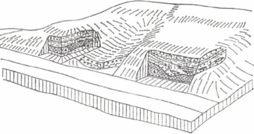
Fig. 5. Geomorphological position of the dislocated and remodelled tropical etchplain remnants o f the Transdanubian Mountains (after Pécsi, M.). - a i-a2 = buried surface of etchplain in a sub- or intra
montane graben; b = surface of planation in threshold position, exhumed and reshaped etchplain; c = buried planated surface in uplifted position, etchplain remnant partly planated in the course o f deposi
tion o f Oligocene gravel sheet over it; d = exhumed etchplain in summit position, reshaped etchplain by (peri)pedimentation; e = uplifted, partially exhumed Cretaceous etchplain remodelled by pedimentation during the Tertiary (e.g. Oligocene) in the forelands o f the crystalline massifs, with conglomerate covers over their subsided part; P-P| gr = Pliocene-Pleistocene gravel; M2-M3 = M iddle Miocene marl, limestone and gravel; E2I = Middle Eocene limestone; Eid = Lower Eocene dolomite detritus; Cr b = Upper Cretaceous bauxite; Tr3 d = Triassic dolomite; M gr = M iocene gravel; M 2 - M 3 gr = Middle and Upper Miocene gravel and conglomerate; Tr., J.d.l = Triassic and Jurassic dolomite and limestone;
O .cong = Oligocene sandstone and conglomerate; (1) = remains o f tropical weathering, with kaolinite and red clays; (2) = unconformity; (3) = tower karst remnant o f a tropical peneplain; (4) = gravel patches on the surface
It is occasionally difficult to determine the age of remodelling of the uncovered exhumed hörst. In these cases one may start from the fact that the surface of horsts of the Transdanubian Mountains was planated already in the Cretaceous, the surface of those of low position slightly changed during the Tertiary, it is inherited. The uncovered horsts of morphologically higher position could be pediplanated in the course of the Paleogene and became pedimented at their margin during the Neogene.
Each of the horsts etchplanated in the Cretaceous then buried, semi-exhumed and being uncovered may occur at different elevations (Figure 5). Some types can be found e.g. at the same height besides each other within the same mountain unit. It is also common that the planated horsts covered by Oligocene sandstone overlie stepwise one another. The surfaces of different heights of these hörst types do not represent geomor
phological surfaces of different ages.
In the mountain margins the Neogene marine terraces represent usually younger geomorphological surfaces that the uplifted and exhumed hörst surfaces. Nevertheless, it is common that the Pannonian marine formations overlie horsts uplifted to 400 to 500 m height which were buried in the Paleogene (Buda Mountains), elsewhere upper Panno
nian travertine occurs on the Mesozoic geomorphologic surface (Balaton Upland, ca.
300 m above sea level).
In some cases we find foothill surfaces in marginal positions, transformed by Paleogene and/or Neogene pedimentation. These may be further shaped by Quaternary cryoplanation and accumulative glacis formation. This way generations o f surfaces o f different ages may be preserved on horsts or in their vicinities.
On the margins of horsts of the Transdanubian Mountains the Late Cainozoic geomorphological surfaces (marine terraces, pediments, river terraces) were preserved by the hard strata of travertines from the subsequent erosion. Travertines were formed by karst springs in the base level. In the Transdanubian Mountains 12 Neogene and Quaternary geomorphological surfaces were preserved by travertines. This phenomenon is characteristic of the mountain margins and of some larger valleys. In the valley-side ten-aces a lower sequence of travertines is deposited (between 120 and 250 m altitudes).
The higher situated sequence of travertine covers the pediments and marine terraces. To determine their age, fauna remnants paleomagnetic and absolute chronological data were available (Pécsi, M., Scheuer, Gy. and Schweitzer, F. 1988).
CONCLUSIONS
Based on comparative geomorphological observations, a model o f surface evolution through alternating erosion and accumulation is proposed, which is here used as a tool for understanding the evolution of surfaces on horsts and grabens in the Trans
danubian Mountains (TM). This model aims at an improving of accuracy of terminology (Pécsi, M. 1970a,b, 1975, 1993).
The basis of this model fo r alternating erosion and accumulation is that fo r
merly developed (by tropical etchplanation, pedimentation, pediplanation) surfaces of erosion are repeatedly reshaped by erosion and accumulation during subsequent geo
logical times. The morphostructural element is repeatedly uplifted and subsided and horizontally displaced by tectonic processes.
This model proposes that in the TM the conditions resulting in erosional sur
faces, due to tropical tower-karstic planation and accompanied by bauxite formation, were interrupted by the beginning of the Tertiary. This was mainly caused by changes in climate and in tectonic activities. During the Tertiary the bulk of the TM was repeatedly buried by tectonic subsidence under sedimentary sequences of different thickness. Some regions were partially or entirely elevated and exhumed twice or three times (during the Paleogene, Neogene and Quaternary). The karstic etchplain surface of Cretaceous origin was further eroded or buried under sediments during these repeated burial and exhuma
tion events (e.g. by peripedimentation, formation of marine terraces, or alluvial fans).
The TM, subdivided by grabens, contains five different groups of geomorphological surfaces:
1. Horsts of etchplanation in summit level, partly exhumed;
2. Buried horsts of etchplanation in uplifted position;
3. Horsts of etchplanation in threshold position, buried or exhumed and re
shaped, mainly by pedimentation;
4. Buried etchplain in basins (cryptoplain);
5. Peripediments, rocky pediments, glacis, partly covered by alluvial fans.
On the "Geomorphological Map of Hungary" (Pécsi, M. 1976) and on the
"Geomorphological Map of the Danubian Countries" (Pécsi, M. 1977, 1980) and re
gional landscape monographs on the TM (Pécsi, M. 1988, Pécsi, M. and Juhász, Á.
1990) the term erosional-accumulational surface evolution was used for the develop
ment of those geomorphological surfaces for which sufficient information was available, according to the principles and criteria of the proposed model. The model explaining and classifying the erosional surface evolution describes the surfaces of planation, bur
ied surfaces, repeatedly exhumed and eroded planes, illustrates the polycyclic process of their superposition and reveals the main phases of the changes.
After three decades of observations in this field we think that the explanation is not just valid for the individual Intracarpathian Mountains, but may be applied in the cases of the Alpine-Dinarid mountain system, of some European ancient mountains, or of mountains and massifs of various continents.
The superposition of geomorphological levels of different ages could be dem
onstrated in the case of the units of the TM, using the procedures of denudation- and accumulation chronology. The particular case of it has been published several times in Hungarian and in other languages, summarised in a monograph of the Transdanubian Mountains (Pécsi, M. 1970a,b, 1993; Pécsi, M. and Juhász, Á. 1990; Pécsi, M. et ál.
1985; Székely, A. 1972).
In the Gerecse, Buda, and Pilis Mountains (TM) the presence of almost all young geomorphological levels could be demonstrated in some sections, in addition to older ones. In the forelands of these Mountains the higher levels were represented by 3 or 4 Neogene marine terraces and deltas, by 1 to 2 foothill surfaces, and by 4 to 6 Qua
ternary fluvial terraces (Figure 4). These geomorphological levels were protected against subsequent denudation by travertines capping them. Thus a reconstruction of long-term morphological evolution of geomorphological surfaces became feasible (Pé
csi, M. 1975, 1993; Pécsi, M. et al. 1985).
The chronological classification of the geomorphological surfaces gave us a key to outline the geomorphic evolution of TM during the Cainozoic era.
REFERENCES
Balla, Z. 1988. Tertiary paleomagnetic data for the Carpatho-Pannonian region in the light o f the M io
cene rotation kinematics. - Földtani Közlöny. 139. pp. 67-98.
Báldi, T. and Kókay J. 1970. Die Tuffitfauna von Kismaros und das after des Börzsönyer Andesitvul- kanismus. - Földtani Közlöny. 100. pp. 274-284.
Báldi, T. 1982. A Kárpát-Pannon rendszer tektonikai és ősföldrajzi fejlődése a középső tercierben.
(49-19 millió év között) (Tectonic and paleogeographic evolution o f the Carpatho-Pannonian system in the middle Tertiary, between 49-19 Ma BP.). - Őslénytani Viták. 28. pp. 79-155.
Bárdossy, Gy. 1973. Bauxitképződés és lemeztektonika (Bauxite formation and the plate tectonics). - Geonómia és bányászat. MTA X. osztály közlemények. 6/1-4. pp. 227-240.
Bárdossy, Gy. 1977. Karsztbauxitok (Karstic bauxites). - Akadémiai Kiadó. Budapest, 413. p.
Bremer, H. 1986. Geomorphologie in den Tropen-Beobachtungen, Prozesse, Modelle. - Geoökody- namik. 7. pp. 89-112.
Bulla, B. 1958. Bemerkungen zur Frage der Entstehung von Rumpfflächen. - Földrajzi Értesítő. 7. 3.
pp. 266-274.
Büdel, J. 1957. Die "doppelten Einebnungsflächen" in feuchten Tropen. - Zeitschrift für Geomor
phologie. N.F. 1. pp. 201-228.
Davis, W.M. 1906. Geographical Essays. - Ginn, Boston. New edition: 1954, Dover, New York, 777 p.
Davis, W.M. 1922. Peneplains and the geographical cycle. - Bull, o f Geol. Soc. o f Amerika. Baltimore.
Vol. 33. pp. 587-598.
Fülöp, J. 1989. Bevezetés Magyarország geológiájába (Introduction in Geology o f Hungary).
Akadémiai Kiadó, Budapest. 246 p.
Géczy, B. 1974. Lemeztektonika és a paleontológia (Plate tectonics and paleontology). - Földtani kutatás. 17/3. pp. 17-20.
Hámor, G. 1989. Paleogeographic reconstruction o f Neogene plate movements in the Paratethyan realm. - Acta Geologica Hungarica. 27/12. pp. 5-21.
Horváth, F. 1974. Application o f plate tectonics to the Carpatho-Pannonian Region. - Acta Geologica Hungarica. 18. pp. 243-255.
Horváth, F., Stegena L. and G éczy, B. 1974. Szialikus és szimaikus ívközi medencék (Sialic and simaic inter-arc basins).- Földtani Kutatás. 17/3. pp. 11-16.
Howard, A.D. 1992. Pediment passes and the piedmont probleme. - Journal o f Geomorphology. 5. pp.
1-31.
Jaskó S. 1988. A Magyar-középhegység neogén rögszerkezete (The Neogene block structure of the Central Hungarian Range). - Földtani Közlöny. 118. pp. 325-332.
Jámbor A. 1989. Review o f the geology of the s.l. Pannonian formations o f Hungary. - Acta Geologica Hungarica. 32. pp. 269-324.
Juhász A. 1988. A Bakonyvidék (The Bakony Region). - In: Pécsi, M. (ed.) A Dunántúli-középhegység B. (Magyarország tájföldrajza 6). Akadémiai Kiadó, Budapest, pp. 31-101.
Juhász, E., Korpás, L. and Balogh, A. 1995. Two hundred million years o f karst history, Dachstein Limestone, Hungary. - Sedimentology. 42. pp. 473-489.
Kázmér, M. 1984. A Bakony horizontális elmozdulása a paleocénben (Horizontal displacement o f the Bakony Mountains during the Paleocene). - Általános Földtani Szemle. 20. pp. 53-101.
King, L.C. 1949. The pediment landforms: some current problems. - Geological Magazine 86. pp.
245-250.
King, L.C. 1962. The Morphologische Analyse. - Oliver & Boyd, Edinburgh and London.699 p.
Kretzoi M.and Pécsi M. 1982. A Pannóniai-medence pliocén és pleisztocén időszakának tagolása . - Földrajzi Közlemények. 30. (106) 4. pp. 300-326.
Kretzoi, M. and Pécsi, M. 1979. Pliocene and Pleistocene development and chronology o f the Panno
nian Basin. Acta Geologica Acad. Sei. Hung. 22. 1-4. pp. 3-33.
Luis, A. 1957. Rumpfflächenproblem, Erosionszyklus und Klimamorphologie. - Geomorphologische Studien, Mahatschek Festschrift. Berlin, pp. 19-26.
Mackin, J.H. 1970. Origin o f Pediment in the Western United States. - In: Pécsi, M. (ed.) Problems of relief planation. (Studies in Geography in Hungary 8.) Akadémiai Kiadó, Budapest, pp.
85-105.
Maxon, J.M. and Anderson, G.H. 1935. Terminology o f surface forms o f the erosion cycle. - Journal of Ecology. 43. pp. 88-96.
Márton, P. and Szalay, E. 1981. Mezozoic paleomagnetism of the Transdanubian Central Mountains and its tectonic implications. - Tectonophysics 72. pp. 129-140.
Mindszenty, A., Knauer, J. and Szantner F. 1984. A z iharkúti bauxit üledékföldtani jellegei és felhal- mozódási körülményei (Sedimentological features and the conditions of accumulation of the Iharkút bauxite deposit). - Földtani Közlöny. 114. pp. 19-48. (English summary: pp. 41-44.) McGee, W.J. 1897. Sheetflood erosion. Bull, o f Geological Society o f America. 8. pp. 87-112.
Penck, W. 1924. Die Morphologische Analyse. - Stuttgart. 277 p.
P écsi M. 1963. Hegylábi (pediment) felszínek magyarországi középhegységekben. - (Summary in German: Fußflächen in der Ungarischen Mittelgebirge). - Földrajzi Közlemények. 11. (87) 3.
pp. 195-212.
P écsi, M. 1968. Denudational levels o f the Hungarian Middle Mountains with special regard to pedi
ment formation. - The geomorphological and terminology problems of the denudation features of middle mountains and their pediments (Symposium). Inst, o f Geogr. Hung. Acad, o f Sei., Budapest, pp. 24-36.
P écsi M. 1969a. A Balaton tágabb környékének geomorfológiai térképe (Geomorphological map o f the broader environs o f Lake Balaton). Kísérlet Magyarország áttekintő (1:300 000-es) geomor
fológiai falitérképének elkészítéséhez. - Földrajzi Közlemények. 17. (93) 2. pp. 101-112.
P écsi M. 1969b. A hegységek és előterük lepusztulásformáinak kutatásáról rendezett nemzetközi szimpózium főbb eredményei (The geomorphological and terminology problems o f the denu
dation features o f middle mountains and their pediments). - MTA Föld- és Bányászati Tud.
Oszt. Közleményei. 2. pp. 319-321.
P écsi, M. 1970a. Geomorphological regions o f Hungary. (Studies in Geography in Hungary 6).
Akadémiai Kiadó, Budapest. 45 p.
P écsi, M. 1970b. Surfaces o f planation in the Hungarian mountains and their relevance to pedimenta- tion. - In: Pécsi, M. (ed.) Problems o f relief planation. (Studies in Geography in Hungary 8) Akadémiai Kiadó, Budapest, pp. 29-40.
P écsi M. 1974. A Budai-hegység geomorfológiai kialakulása, tekintettel hegytípusaira (Geomorphic evolution o f the Buda Mountains and its mountain types). - Földrajzi Értesítő. 23. 2. pp.
181-192.
P écsi M. 1975. Geomorphological evolution o f the Buda Highland (Hungary). - Studia Geomor- phologica Carpatho-Balcanica. Kraków. 9. pp. 37-52.
P écsi M. 1976. Magyarország geomorfológiai térképe (The geomorphological map o f Hungary.
1:500 000. Legend). - Földrajzi Közlemények. 24. (100) 1-2. pp. 34-41. (in Hungarian), pp.
42-44. (in English).
P écsi, M. 1977. Geomorphological map o f the Carpathian and Balkan regions (1:1 000 000) + Part of the 1:1 000 000 scale geomorphological map o f the Carpathian region (Map). - Studia Geomorphologica Carpatho-Balcanica. 11. Kraków. pp. 3-31.
P écsi, M. 1980. Erläuterung zur geomorphologischen Karte des "Atlasses der Donauländer". - Öster
reichische Osthefte. 22. 2. pp. 141-167.
P écsi, M. 1983. A Dunántúli-középhegység sasbérc felszínei és a denudációs kronológia (Horsts in the Transdanubian Mountains and denudation chronology). - Földrajzi Értesítő 32. 3-4. pp.
504-505.
P écsi, M. 1987a. Domborzat (Relief). - In: Pécsi, M. (ed.) A Dunántúli-középhegység, A. (Magyaror
szág tájföldrajza 5.) Akadémiai Kiadó, Budapest, pp. 140-176.
P écsi, M. 1987b. Domborzatfejlödés és a geomorfológiai szintek korrelációja (R elief evolution and correlation o f geomorphological levels). In: A Dunántúli-középhegység A. (Magyarország tájföldrajza 5.) - Akadémiai Kiadó, Budapest, pp. 131-139.
P écsi, M. 1988. Geomorfológiai szintek kora a Magyar-középhegységben. (Summary in English: Age of geomorphological surfaces in the Hungarian Mountains.) - Földrajzi Közlemények. 36.
(112) 1-2. pp. 28-41.
P écsi, M. 1993. Landform evolution model o f alternating erosional-accumulational geomorphic sur
faces. - Indian Journal o f Landscape Systems and Ecological Studies. 16. 2. 1-7.
P écsi, M. and Juhász, Á. (eds) 1990. Excursion Guide. Symposium and Field Excursion in Bakony Mountains. First Hungarian-Slovene Geographical Seminar. 27-28. Sept. 1990. Geogr. Res.
Inst. Hung. Acad. Sei., Budapest. 65 p.
P écsi, M., Scheuer, Gy., Schweitzer, F., Hahn, Gy. and Pevzner, M.A. 1985. Neogene-Quaternary geomorphological surfaces in the Hungarian Mountains. - In: Kretzoi, M. and Pécsi, M. (eds) Problems o f the Neogene and Quaternary. (Studies in geography in Hungary 19.) Akadémiai Kiadó, Budapest, pp. 51-63.
Pécsi, M., Scheuer, Gy. and Schweitzer, F. 1988. Neogene and Quaternary geomorphological surfaces and lithostratigraphical units in the Transdanubian Mountains. - In: Pécsi, M. and Starkei, L.
(eds) Paleogeography o f Carpathian Regions. Geogr. Res. Inst. Hung. Acad. Sei., Budapest, pp. 11-41.
Pécsi, M. and Szilárd, J. 1970. Planated surfaces: Principal problems o f research and terminology. - In:
Pécsi, M. (ed.) Problems o f relief planation (Studies in geography in Hungary 8) Akadémiai Kiadó, Budapest, pp. 13-27.
Ság, L. and Pécsi, M. 1987. Kainozoikum (Cenozoic). In: A Dunántúli-középhegység A. (Magyaror
szág tájföldrajza 5.). Akadémiai Kiadó, Budapest, pp. 75-122.
Schweitzer, F. and Scheuer, Gy. 1988. A Gerecse és a Budai-hegység édesvízi m észköösszletei (Tra
vertines in the Gerecse and Buda H ills). - Földrajzi Tanulmányok. 20. Akadémiai Kiadó, Bu
dapest. 129 p.
Stegena, L. and Horváth, F. 1978. Kritikus tethysi és pannon tektonika. - Budapest, Földtani Közlöny.
108. pp. 149-157.
Székely, A. 1972. Az elegyengetett felszínek típusainak rendszere magyarországi példákon. (Summary in German and in English: A system o f planation surface type - on examples from Hungary). - Földrajzi Közlemények 20. 1. pp. 43-59.
Wayland, E.J. 1937. Peneplains and some erosional platforms. - Bulletin geological Surawy Uganda.
Ann. rest. Bull. 1. pp. 77-79.
Wein, Gy. 1977. Magyarország neogén előtti szerkezetföldtani fejlődésének összefoglalása (A review o f pre-Neogene tectonics in Hungary) - Földrajzi Közlemények. 25. pp. 302-328.
Wein, Gy. 1978. A Kárpát-medence kialakulásának vázlata (An outline o f the evolution o f the Car
pathian Basin). - Ált. Földtani Szemle. 11. pp. 5-34.
L. Bassa-A. Kertész (eds): Windows on Hungarian Geography
Studies in Geography in Hungary 28, Geographical Research Inst. HAS, Budapest 1998, pp. 23-36
LATE GLACIAL AND POST GLACIAL DEVELOPMENT OF DRAINAGE NETWORK AND THE PALEOHYDROLOGY IN
THE GREAT HUNGARIAN PLAIN
GYULA GÁBRIS
Department of Physical Geography, Eötvös Lordnd University H-1083 Budapest, Ludovika tér 2
INTRODUCTION
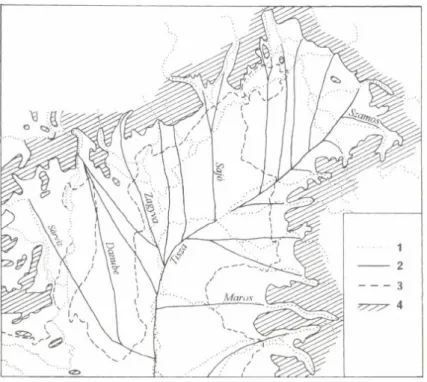
The preliminaries of present day river network of the Great Hungarian Plain date back to the gradual regression of the last marine inundation (Pannonian in the Mio- Pliocene). Rivers arriving from the surrounding mountain ranges to the flatland had built up alluvial fans, depositing their coarse materials in the marginal areas and only carried the finer sediments towards the centre of the basin. The Danube only acted as a transit stream and the Tisza river was the major axis of the drainage (Figure 1). The geological and geomorphological investigations have confirmed the Pleistocene (s. 1.) development of the Great Plain and in more general that of the Carpathian Basin’s drainage (Sümeghy, J. 1944, Somogyi, S. 1961, Rónai, A. 1985, Borsy, Z. 1989, Mike, K. 1991), but the details of the Late Glacial-Holocene events are not clear in a number of regions.
Later a complete transformation of the spatial pattern of the river systems oc
curred in Northern Europe emerging after the regression of the ice cover, but the Car
pathian Basin belonged to the periglacial and pseudoperiglacial region during the last glaciation. The development of the already existing drainage network was highly af
fected by the uneven sinking of the regions in the Great Hungarian Plain. Beside the tectonic effects the climatic fluctuations were important too. These climatic changes had caused fluctuations in water discharge and modified river mechanisms.
Fig. 1. The drainage system at the Upper Pleniglacial. - 1 = present day river courses; 2 = ancient rivers; 3 = contour-line o f the 100 m a.s.l.; 4 = hills and mountains above 200 m
THE EFFECTS OF UNEVEN SUBSIDENCE
The tectonically well differentiated young depressions of the Great Plain - which showed marked variation in their general appearance too - were named by Sümeghy, J. (1944) "offspring-depressions". They were formed on the margin of the basin - far away from the continuously sinking central parts - and their intense subsi
dence has been much younger, generally starting with the end of the Pleistocene and the beginning of the Holocene.
The most important consequence of the formation of these offspring- depressions is the change in flow direction of the Great Plain’s main river; by the end of the Pleistocene the Tisza had moved from the axis of the basin to its current position, closer to the foreland of the northern mountains (Figure 2). The time of the Tisza’s shift was dated at the boundary of Pleistocene and Holocene (Somogyi, S. 1961, 1967, Borsy, Z. 1968). Recently an idea has been raised (Borsy, Z. 1989) that the Tisza occupied its actual position (near the town of Tokaj) much earlier (16-20,000 BP). Considering the evidence provided by both theories the change of flow direction of the Tisza can be
Fig. 2. The drainage system at the end o f the Pleistocene, during the „warm and humid" phases (Böl- ling/Alleröd) o f the Late Glacial. - 1 = present day river courses; 2 = ancient rivers; 3 = contour-line o f the 100 m a.s.l.; 4 = hills and mountains above 200 m; 5 = offspring basins
dated to the Late Glacial instead of the Preboreal, presumably after the loess formation, notably during the Bölling/Alleröd "warm" phases, and a gradual change, or the bifur
cation of the river during the Late Glacial-Preboreal shall be supposed. The author’s latest investigations suggest the Late Glacial flow direction of the Tisza through the Hortobágy to the south (Fiar, S. and Gábris, Gy. 1995), but the presence of the river in its actual position along the middle reaches of the Tisza is also evident at this time.
The changing position of the Tisza was followed by the change of courses of its tributaries: the northern tributaries became shorter, while the southern ones became longer. Apart from this major change the main tributaries moved their channel only slightly within their alluvial fans. Only the history for the last 13,000 years of some of the rivers is described in detail namely that of Szamos (Borsy, Z. 1954, Benedek, Z.
1960), Maros (Gazdag, L. 1964), Sajó (Gábris, Gy. 1970), Bodrog ( Borsy, Z. and Félegyházi, E 1983, Borsy, Z. et al. 1989).
The river courses of distinet periods might be identified by the numerous aban
doned river branches of different size. The geomorphological investigations of these meanders applying sedimentological and palynological methods served to map the change of the flow directions. The Late Glacial-Post Glacial development of the
Zagyva-Tarna drainage system and the alluvial fan of the Sajó river serves as a good example of these new results (Figures 3 and 4).
THE ROLE OF THE CLIMATE
The geomorphological effects of the climatic changes on the rivers are varied:
- The discharge fluctuation of the rivers caused the variation of the size of the river meanders. Based on the size and age of the abandoned river branches the Late Glacial and Holocene development of the alluvial fans in the Great Plain and the paleo- hydrology of the basin can be established,
Fig. 3. Late Glacial-H olocene changes in the drainage system o f Zagyva and Tarna rivers. - River courses: 1 = Alleröd (Zagyva); 2 = Preboreal (Zagyva and Tarna); 3 = Boreal (Tisza); 4 = Subboreal (Zagyva-Tarna).
Fig. 4. Late G lacial-H olocene changes in the drainage system on the alluvial fan o f the Sajó river (Gábris 1970). - River courses: 1 = Alleröd; 2 = Preboreal; 3 = Boreal
- The changing mechanism of the climate controlling rivers resulted in the for
mation of terraces and flood plain systems.
Correlation between meander properties and paleodischarges in the Great Hungarian Plain
During the past decades a number of researchers conducted measurements and calculations with regard to the statistical relationship between the discharge rates of the meandering rivers and the size of meanders. The discrepancies between the derived
Fig. 5. Two groups o f the Hungarian rivers on the base o f the relations: a = between the length o f meander chord and the gradient; b = between the gradient and the grain size o f the bed load;
c = between the gradient and the bed load
regression equations (Williams, G. P.
1984) can be attributed to the various measurement methods, and mainly to the distinct physical geographical environment of the investigated regions.
The author has derived a relationship between the meander parameters of active meanders and the present discharge properties of various rivers on the Great Hungarian Plain (Gábris, Gy.
1985, 1987). This method seemed appropriate to use for establishing the paleohydrology of the Great Plain. Using the above mentioned equations between the river discharge and meander properties the paleodischarge could be calculated from the size of the meanders left by the ancient rivers at the time of bend abandonment (Gábris, Gy. 1986).
For a better estimation of the discharge of ancient rivers, along with the meander data a number of other parameters were used too. In the data base for the new calculations the channel geometry (i. e.
width, depth, cross-section area), slope gradient, the bed sediment and bed load material data was also included. The rivers of the Great Plains fall into two groups by gradient, channel material and the amount of sediment yield (Figures 5 and 6). The calculations to determine the regression formulas were carried out for both groups of the rivers (Figure 7).
DISCHARGE FLUCTUATIONS
A wide variation of abandoned alluvial meanders has already been discovered on the Great Hungarian Plain by many Hungarian geographers and geologists. The me
ander characteristics measured for active rivers have also been determined on these abandoned meanders. The abandonment of the channels has been dated using radiomet-