PHYSICO-
GEOGRAPHICAL RESEARCH
IN HUNGARY
Geographical Research Institute Research Centre for Earth Sciences
Hungarian Academy of Sciences
PHYSICO-GEOGRAPHICAL RESEARCH IN HUNGARY
STUDIES IN GEOGRAPHY IN HUNGARY, 32
Geographical Research Institute Research Centre for Earth Sciences
Hungarian Academy of Sciences
Editorial board L. BASSA M. CSUTÁK Á. KERTÉSZ F. SCHWEITZER
PHYSICO-GEOGRAPHICAL RESEARCH IN HUNGARY
The publication of the present volume was supported by the National Scientific Research Fund (OTKA), Project No. T 034730.
Edited by ÁDÁM KERTÉSZ FERENC SCHWEITZER Geographical Research Institute Research Centre for Earth Sciences
Hungarian Academy of Sciences
GEOGRAPHICAL RESEARCH INSTITUTE HAS BUDAPEST 2000
Preparation for printing carried out at the Geographical Research Institute Research Centre for Earth Sciences Hungarian Academy of Sciences (GRI RCES HAS)
Computer typesetting and layout:
ESZTER GARAI
Technical editor:
LÁSZLÓ BASSA
Technical staff:
ALEXANDRA KOVÁCS, ISTVÁN POOR
ISBN 963 7395 83 0 HU ISSN 008 1-7961
© FERENC SCHWEITZER, director of the GRI RCES HAS, 2000 All rights reserved. No part of this book may be reproduced by any means, transmitted or
translated into machine language without the written permission of the publisher
Published hy Geographical Research Institute Research Centre for Earth Sciences Hungarian Academy of Sciences, H -l 1 12 Budapest, Budaörsi út 43-45.
Printed in Hungary by EXEON Bt.
C O N T E N T S
PREFACE ...7
I. GEOCHRONOLOGY
SCHWEITZER. FERENC: Geomorphic Evolution in the Carpathian Basin during the Late Cenozoic and the Pliocene Epoch ... 9 PÉCSI, MÁRTON-SCHWEITZER, FERENC-Y AMSKI KH, ANATOLY-
FRECHEN, MANFRED: Comparative Studies of Terraces and Loess
Sections in the Vicinity of Krasnoyarsk in the Yenisey V alley... 29 LOVÁSZ. GYÖRGY: Reconstruction of Some Holocene Geomorphic Processes
in Hungary...43 GÁBRIS. GYULA-HORVÁTH, ERZSÉBET-NOVOTHNY. ÁGNES-UJHÁZY,
KOLOS: Environmental Changes during the Last-, Late- and Post-Glacial in Hungary...47
II. GIS APPLICATIONS
KERTÉSZ. ÁDÁM-HUSZÁR. TAMÁS-TÓTH, ADRIENN: Soil Erosion
Assessment and Modelling... 63 SZABÓ. SZILÁRD-KERÉNYI, ATTILA: New Aspects of Mapping Methods of
Soil Sensitivity as a Factor of Landscape Loadability... 75 KISS. RICHÁRD-MEZŐSI. GÁBOR: Mapping Vertical Relief Dissection
Using GIS... 85
III. STUDIES ON KARST ECOLOGY
JAKUCS, LÁSZLÓ: Karst Is a Biological Product...93 BÁRÁNY-KEVEI, ILONA: Ecological Investigation on Some Hungarian Karsts.... 111 VERESS, MÁRTON: Demonstration of Past Sediment Cover on Present-Day
Karst Landscapes... 1 19 ZÁMBÓ, LÁSZLÓ-FORD, DEREK-TELBISZ, TAMÁS: Evaluation of
speleothem age data from Baradla cave (NE-Hungary) with respect to late Quaternary climatic oscillations... 135
IV. CHANGES IN LANDSCAPES
SZABÓ, JÓZSEF: Landslide activity and Land Utilisation at the High
River Bank Zones... 143 MAROSI, SÁNDOR: Man-made Impact Assessment at Geotopological Level ... 153 LÓCZY, DÉNES: Issues of Landscape Change in Hungary: an Evaluation of
Impacts of Land Privatisation and Reclamation ... 161 HORVÁTH, GERGELY-KARANCSI, ZOLTÁN-PINTÉR, ZOLTÁN: The Medves
Plateau... 169
Preface
Nowadays the trend of globalisation is absorbing all spheres of life. The cumu
lative environmental problems, the expansion of tourism, the information boom all have contributed to an ever-increasing interest of the public and academic audience toward earth sciences. This issues a real challenge to geography which is trying to take it up and respond to it by the development of new methods and by the application of the recent scientific results for the solution of functional problems of society and economy. It does not mean, naturally, that the 'classical' branches of geography wither and the related fundamental research have been neglected because the solutions of practical tasks are increasingly based upon them.
This volume of studies is aimed at the presentation of the state-of-the-art of re
search activities in physical geographical studies in Hungary and achievements over the last few years. The contributions have been selected with the purpose that the geo
graphical workshops in Hungary be represented and beyond the geomorphologie domain being traditional in the Hungarian physical geography, other and more recent subjects such as landscape ecology and management, GIS applications be presented. The studies were grouped into four chapters according to their thematic content.
In the first chapter some of the results in the field of geochronology were pre
sented. Within this topic the late Neogene has long been a cardinal problem. It was put in the focus of the study by F. SCHWEITZER deserving a special attention. The author has dealt with evidence to the past tropical arid climate in the Carpathian Basin simulta
neous with the formation of Mediterranean Upper Miocene Messinian strata, thus re
formulating the chronology of the Hungarian landscape evolution. The article offers a synthesis of the related knowledge so far accumulated by various branches of geosciences. Quaternary studies being a paramount subject in Hungary also belong to the latter. M. PÉCSI and colleagues report on terrace morphological and loess chrono
logical investigations in the Yenisey valley under the aegis of global correlation. Two contributions deal with environmental changes during the late Pleistocene and Holocene.
Of them the first one (by Gy. LOVÁSZ) treats possible blown sand formation and land
slide occurrence by Holocene phases. Gy. GÁBRIS and colleagues have modified the former Quaternary stratigraphy in Hungary. The geomorphological analysis of se
quences comprising loess, sand and paleosols supported by the luminescence dating method has led to a conclusion (among others) that there was a dry interval (even if a short one) during the Atlantic, about 6000 years ago. These new result contradict the former concept about Holocene, considering the Atlantic the most humid phase of that epoch. TL and IRSL, recently used in loess-paleosol stratigraphy has met with skepti
cism by many experts as reliable dating methods. At the same time it is a fact that once a new scientific result does not fit in the hitherto accepted concept it should overcome barriers to become recognised.
GIS and different kinds of digital models have recently become widespread also in Hungarian geography. The second chapter is an evidence to this trend. Á.
KERTÉSZ and colleagues provide soil erosion assessment by one of the latest computer models. An essay by Sz. SZABÓ and A. KERÉNYI also deals with a typical environ-
mental problem, soil acidification. The mapping of this process within a test area is solved using a GIS software. GIS is a correct method in geomorphologic research as it exemplified by the article of R. KISS and G. MEZŐSI. The authors explore possible reconstructions of past landscape evolution within a model area including changes in the drainage network and catchment, with a special reference to variations in erodibility of the different parts. The method is based on the postulate that for each Horton-Strahler drainage system the absent volume i.e. the vertical dissection can be defined (by GIS, models, DTM). Knowing the geological history of the area, the evolution of the water
shed can be calculated. The article provides new evidence to temporal changes in river systems through the analysis of data relating to streams.
The third chapter is devoted to karst research as one of the most developed branches in Hungarian geography and probably the most intrinsic subject of the latter.
This is well represented by two contributions of L. JAKUCS and I. KEVEI-BÁRÁNY in which landscape ecological approach and the ideas of complexity prevail. In a case study by M. VERESS the problems of geomorphological reconstruction and differentia
tion of the paleokarsts are tackled and methods of investigation into the cover strata are described. The study of karst can also be used in the reconstruction of the Quaternary. It is well exemplified by the article of L. ZÁMBÓ et al which besides others, points out that the karstic processes events by the nature of their complexity are highly dependent on climate and are especially sensitive to environmental changes. This way the speleo- them is an excellent indicator of the changes the paleoenvironment. The authors in com
pare the result of the investigations performed in the largest allogenic river cave in Hun
gary, the Baradla, with other paleoclimatic reconstruction methods (quartermalacology, oxygen isotope) as well as the result gained by analogous methods applied in other Northwest European caves and the data obtained are parallel. Interesting conclusions can be drawn for the two above regions in the case if they represent differing character
istic features.
Finally, the fourth chapter contains studies on the interrelationship between landscape evolution and issues of present-day land uses. It begins with J. SZABÓ's case study dealing with the problems of a Hungarian region endangered by landslide hazard and coming to an intriguing conclusion with regard to its modern utilisation. S.
MAROSI treated a flood plain area of the Danube and formulated recommendations as to the prospects of its man induced development. D. LÓCZY analysed the overall im
pact of land privatisation upon Hungarian landscapes and also dealt with the reclamation of areas abandoned by mining. G. HORVATH and colleagues wrote an essay, which is a classical landscape description with a substantial attention paid to landforms and proc
esses as a consequence of human intervention.
Recommending this short volume of studies to the reader may we hope that he will be provided an insight into the recent physico-geographical research in Hungary, at the same time getting acquainted with achievements as a result of technical development and the dissemination of new* scientific theories and methods on the one hand and expectations of the society on the other hand. Both professionals in geography and a wider audience interested in geosciences can make use of this publication.
The Editors
A. KERTÉSZ and F. SCHWEITZER (eds): Physico-geographical Research in Hungary Studies in Geography in Hungary 32, Geographical Research Inst. HAS, Budapest 2000, pp. 9-27.
GEOMORPHIC EVOLUTION IN THE CARPATHIAN BASIN DURING THE UATE CENOZOIC ANI) THE PUIOCENE EPOCH
FERENC SCHWEITZER1 Introduction
The present paper is an attempt to summarise the achievements reached by the author during the past 10-12 years of investigation into the specific features of landform evolution in the Pannonian Basin during the Late Cenozoic and early Quaternary. The major geomorphic processes having taken place at the end of the Upper Miocene and during the Pliocene are also evaluated and landforms described and dated below.
In order to obtain more exact and complex results a special emphasis was put on the application of biochronological-biostratigraphical methods based on the identifi
cation of mammal fauna on the one hand and of paleomagnetic datings ( absolute chro
nology) on the other hand.
The formation of the present-day surface of Hungary was preceded by a series of events of several million years' duration comprising the formation of rock sequences studied by the geological science. In the course of Earth history marine, terrestrial and volcanic formations came into existence and land surface varied considerably during the different geological epochs. These paleosurfaces and their geomorphic features are studied by diverse research methods of geosciences through paleogeographic recon
structions providing more or less reliable results depending on the amount and quality of geological data.
This retrospective analysis starting with the present is losing its reliability with time because the superimposing geological events eliminate an increasing part of evidence for reconstruction. So, stemming from the character of geological events nei
ther the geomorphological, nor the geological system of data can be complete. This is why geomorphological-geological research always necessitates hypotheses. These hy
potheses, i.e. the respective theoretical bases, however, should always be well-founded.
Hungary is situated in the Carpathian Basin bounded by the Alps, Carpathians and Dinarids and thus its mountains, basement and sediments are akin to geological formations of the modern mountain structures.
This publication was supported by the National Scientific Research Fund (OTKA). Project No. T 019326.
1 Geographical Research Institute. Hungarian Academy of Sciences Budapest 1112. Hungary Budaörsi út 43-45, 1388 Pf. 64.
Several recent studies on tectonism and paleogeography conceived in the the
ory of plate tectonics (GÉCZY. B. 1973, STEGENA, L. 1973, HORVÁTH, F. 1973, MÁRTON, P. and M. SZALAY E. 1978, 1981, BALLA, Z. 1980, 1984, KOVÁCS, S.
1980, 1982, MAJOROS, Gy. 1980, KÁZMÉR. M. 1984, BÁLDI, T. 1982, FÜLÖP. J.
et al. 1988) came to a joint conclusion that the Carpathian Basin (and Hungary) as a uniform area have existed approximately since the Middle Miocene. By this time the area evolved from two lithosphere units: the north-western part of African origin and the south-eastern segment of European origin.
When evaluating the Pliocene epoch a main emphasis was put on general pa- leogeographic relationships since domestic data are often missing.
It was the absence of data from correlative sediments covering the domestic geomorphological levels that stimulated to approximate their age using analogues from remote locations but well studied by other experts and in several cases by the author himself, One of the greatest tasks of the Hungarian geomorphological research is to explain and clarify geomorphic evolution during the Pliocene epoch und to propose a paleogeographic reconstruction.
The duration o f the Pliocene, as suggested by the Italian and French experts, is 2,5-3 m yr; in this period 200 to 1300 m thick sediment sequence was deposited over the intra-basin areas while the basin margins and inland areas were covered by sedi
ments in 10 to 250 m thickness (e.g. Gödöllő sand). The epoch restricted in the above sense resulted in an Eastern European terrestrial sequence figuring in the literature as the Levantan stage. Its further subdivision (Piacenzan, Astian), however, was carried out using data from the Mediterranean. Pliocene sediments from the Carpathian Basin do not completely correlate with the originally described Levantan sediments and levels, i.e. there are contradictory concepts about the boundaries.
That is why the denomination 'Levantan' has recently been abandoned by many and the time interval in concern came to be called Upper Pliocene (when the Mio- cene/Pliocene boundary was placed between the Sarmatian and Pannonian stages) and lately Pliocene stage (with the Miocene/Pliocene boundary drawn at 5.5 m yr).
The Miocene/Pliocene boundary
By the end o f the Miocene the Paratethys had been separated into partial ba
sins. One of the basins was the Pannonian brackish inland sea, sediments of which hardly extend beyond the borders of the present-day Hungary.
In the rapidly submerging catchment of the Pannonian Lake a sequence oi brackish, lacustrine molasse was deposited in a thickness of 4000 m or more, containing sand, fine grained sand, clay and clayey marl. The lake became entirely filled up by the beginning of the Quaternary.
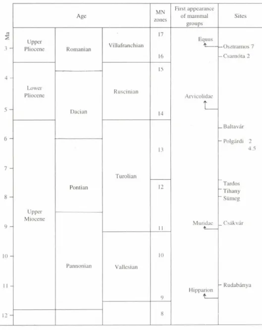
The Upper Pliocene in Hungary is synonymous with Post-Sarmatian. This stage is placed between the Sarmatian and the Dacian, in the terrestrial biological scale be
tween the Astaracium and Ruscinium, in the mammal system by Mein between zones MN 8 and 12 (STEININGER F.F. et al. 1985). Its equivalent in the Hungarian
stratigraphical system is the Kunság stage of Pannonian s. str. (DANK, V. and JÁMBOR, Á. 1987). Formations of the Kunság stage contain basal faunas of the Car
pathian Basin (type localities Rudabánya, Diósd, Sopron, Csákvár, Győrszentmárton, Sümeg, Szabadság-hegy, Polgárdi, Hatvan, Baltavár etc.) and dispersed findings, biostratigraphical analyses of which were performed chiefly by M. KRETZOI (KRETZOI, M. 1942, 1952, 1961, 1969. 1982, 1987, KORDOS, L. 1987).
Previously the Miocene/Pliocene boundary was drawn in the Carpathian Basin at ca 12 m yr B. P., at the end of the Sarmatian. Lacustrine deposits of the Lower and Upper Pannonian and overlying them freshwater-fluvial, so called Levantan, layers were labelled as Pliocene series.
Recently Lower and Upper Pannonian layers have been claimed by many as of Upper Miocene and the Miocene/Pliocene boundary drawn on top of the Messinian stage (Italy) at 5.3 m yr, whereas Upper Pannonian boundary coincides with that of the Pleistocene (2.5 m yr B.P.). The corresponding sediments are represented in Hungary by the Bérballavár sand (KRETZOI, M. 1982).
In the Hungarian stratigraphical practice the lower and upper boundaries o f Pliocene varies therefore it seems to be necessary to write about in what a sense they will be used below.
The lower boundary is drawn, in accordance with the latest international rec
ommendations, between the Messinian and Zanclean at 5.3 m yr, corresponding to the limit between zones MN 13 and MN 14 in the mammal scale by Mein . This was the time of a considerable drop of the level of the Pannonian brackish inland sea, considered a remnant of the Paratethys (Fig. I), to be correlated with the lowering level of the Mediterranean Sea in the Messinian (5.3—6.8 m yr) with the formation of evaporites in that basin ("Messinian Salinity Crisis"). The reasons for this intense evaporite formation are not yet cleared. Some refer to a cyclic separation of the Mediterranean into parts as a result of plate tectonic movements leading to its drying out. Others hold that there had been a complex relationship between the Mediterranean and the Atlantic interrupted by the following events: a global climate change occurring during the 6th paleomagnetic epoch (6.4 m yr B.P.) under the influence of which the ratio of 8 I3C had changed; peak of the Antarctic glaciation (dated 7.4 Ma by the K/Ar method) and a maximum glacia
tion of Dronning Maud Land (5.5-4.5 Ma K/Ar). At that time glaciation of the Antartic 1.5-2-fold exceeded the present-day one and there was a strong asymmetry between the northern and southern hemispheres (BERGGREN, V. et al. 1985, HARLAND et al.
1982). The uplift of the Gibraltar swell and the advent of the "Messinian Salinity Crisis"
occurred at that time.
The termination of the "Messinian Salinity Crisis" is indicated by an almost to
tal desiccation!' the Mediterranean and the Black Sea. From the Black Sea boreholes stromatolites and gravels are known from a depth of 864 m. They correlate with the deposition of the Arenazzolo sand in the Mediterranean region, with the formation of submarine canyons, of salt and gypsum deposits.
The upper boundary o f Pliocene does not coincide with the internationally acccepted 1.8 m yr B.P. In the present paper the Matuyama/Gauss paleomagnetic event i.e. ca 2.4 in yr is adopted as the Pliocene/Pleistocene boundary in accordance with the
Pannonian Lake
Fig. 1. The Pannonian Lake during its maximum extension (JÁMBOR, Á, 1987)
recommendation of the Hungarian Commission on Stratigraphy from 1988. The further subdivision of the Pliocene have been controversial as well. MN zones are taken fo r the basis with a tripartite Pliocene with lower (MN 14), middle (MN 15) and upper (MN 16) parts (KRETZOI, M. and PÉCSI, M. 1979; KORDOS L. 1992); (tables I and 2).
The role of endogenous and exogenous impacts in relief formation and their interrelationships have been evaluated in a different way for Hungary and abroad. Some experts give preference to tectonic movements and even more specialists are adhered to the prevalence of exogenous forces in landform evolution. There are specialists empha
sizing the significance of joint effects of the two in shaping landforms. The topics stud
ied and the aspects of geomorphological research in Hungary have been influenced by the deflation theories of L. LÓCZY (1913) and J. CHOLNOKY (1918), the concept of climatic geomorphology of B. BULLA (1954), the model geomorphic evolution by alternating erosion and accumulation proposed by M. PÉCSI (1980).
These investigations might be intriguing because the process o f elimination o f the brackish inland sea and turning the area into land can be traced so well in few regions and the Carpathian Basin belongs to these. This research includes topics of the filling up and desertification of the inner part of the Carpathian Basin, issues of pedi
ment formation and its chronology, emergence of the river network. It is also linked to problems like the Plio/Pleistocene boundary, the age of red clays and terra rossa forma
tions and the extent of crustal movements during the Late Cenozoic.
Table 1. Correlation o f the Central and Eastern Paratethys (KRETZOI, M. 1987)
M e d ite r ra n e a n
b io c h r o n o lo g y E u ro p e an t e r r e s t r i a l b i o c h ro n o lo g y 2 C e n tra l P a r a te t h y s
£ C o d e s M N Z o n e - C o d e s L ith o s tr a tig ra p h y
Ve/j V C a rp a th ia n B a s in
’><
c Q.
<
Foramini fer zone' Nannoplankton zon Stage1 Group Age Stage* POMEL1853 GANDRY1878 CRUS AFONT197
r-i Os u- LÓ Ú
CRUS AFONT197 MEIN1975
K M ’ R B 4
N N -
13 (T a b ia n iu m - Z a n c le u m )
B a ró tiu m R u scinium 14 22 1 1 2 3
M N 14
<3
£
5 - N—18
n /
Q /
N N -
12 M e s s in iu m B é rb a lta várium *
M N 13 6 -
N - 1 7
/ c
/ 15
7 - "P H a tv äniu m *
M N
crt
~o crt
H
N N - 11
é
S üm eg i um
13 21 10
2 2 12
o 1
o CO
9 - N - 1 6
C s á k vári um
/ /
M N 11
/
Pannonian
1 0 -
N N - >
R h en o h assiu m *
12
/
2 0 b
/
9 /
2 1 b M N
G o 5
10
M N 9
c £ N - 1 5
N N - a
3
B odv aiu m * 20 a 2 1 a
1 2 -
9 «3
JZCJ
M o naciu m * N - 1 4
UÜ
M N 8
5 11 19b 8 2 0 b
( M e d ite r
ra n e a n ) (S a r m a -
tia n ) 1 3 - N —13 N N -
8
(O en in g iu m )*
‘Traditional, so called mixed (bio-litho) taxa; 2Biochronological units; of them* with lithostratigraphic significance as well; 'Author’s proposal (KRETZOI, M .-PÉCSI M. 1979), 4Recommendation of the Pliocene Subcommission of Hungarian Commission on Stratigraphy
Table 2. Fauna o f the classic site Polgárdi (N2) evidencing to the regression o f the Pannonian Lake (KORMOS, T. 1911, KRETZOl, M. 1952, KORDOS, L. 1993), at least in this region o f the Transdanubium.
According to KORDOS (1993) vertebrate fauna at Polgárdi can be correlated with vertebrate fossils found in terrestrial deposits at Crevillente N6 site (Spain) where Messinian marine and terrestrial sediments are
intercalated.
Age MN
zones
First appearance of mammal
groups
Sites
3 -
Upper Pliocene
Lower Pliocene 5 -
7 -
S -
Upper Miocene
10 •
1 2 ■
Romanian
Dacian
Pontian
Pannonian
Villafranchian
Ruscinian
Turolian
Vallesian
17
16 15
14
13
12
10
Equus
t __ -Osztramos 7 -Csarnóta 2
Arvicolidae L _
_ Baltavár - Polgárdi 2
4.5
Tardos ' Tihany
’ Sümeg
Muridae
*___ . Csákvár
Hipparion t __
- Rudabánya
Significant warm-dry intervals during the Late Cenozoic and at the lower boundary of the Quaternary
1. At the boundary of Late Cenozoic and the beginning of the Quaternary the author identified three significant warm and dry intervals in the Carpathian region based on geomorphological investigations and proved by sedimentological, geochemi
cal, paleontological, absolute chronological and paleoclimatic evidence.
In the Pannonian Basin the geomorphological levels are covered by sediments containing fauna remnants enabling conclusions about the occurrence of several intervals with warm-dry and warm-hot climates following the Sarmatian. Although based on the sea level fluctuation curve (HAQ, Z. et al. 1987) POGÁCSÁS, Gy. et al.
(1987) disclosed a sedimentation gap in the Békés Basin at 10.5-11.0 m yr B.P. no evidence of that have been found in the mountains and mountain foreland (Fig. 2).
a) Following the post Sarmatian the. first interval characterised with dry-warm ecological conditions (Ophisaurus, Gerbilina fossils) was the Siimegium (7-8 Ma, zone MN 12).
b) The second warm-dry interval was the Bérbaltavárium (counterpart of the Messinian Salinity Crisis in the Mediterranean). This was the main time of pediment formation. Typical vegetation was macchia, shrub, turning into grassland of semidesert character. Its age is 6.3-5.0 Ma, and belongs to the zone MN 13. Grey, greyish yellow sand deposits formed in considerable thicknesses, often cemented by carbonates under arid climate. In places covered with shallow water, owing to the short route of transpor
tation, unsorted clayey-sandy formations, 'variegated clays' emerged. According to the latest data sand surfaces and desert crusts formed, subsequently covered by red clay and terra rossa in the late Rusciniunt and Csarnotanum and Quaternary sediments.
c) The third important warm-dry interval was the Villányiam. At that time lower, poorly developed pediment surfaces formed; alluvial fans (e.g. Kislángium with camel and ostrich), very probably the most ancient, so called 'warm loesses' (Dunaalmás, Szekszárd) and terra rossa desiccation crack infillings with carbonate veins and concre
tions (Dunaalmás, Villány) belong here (3.0-2.0 Ma, zone MN 16-17).
2. Author attempted at the interpretation and explanation of the evolution o f plains in semidesert and steppe environments which has been a topic fo r a century-long debate.
A surface evolution hypothesis on the so called desert phase of the Carpathian Basin have been discussed by many (also from geological, geomorphological and pale
ontological aspects). A limited validity of a desert phase during the Pannonian and Pontian, voiced by LÓCZY, L. (1890, 1913), was accepted by several scientists but in the Pleistocene exclusively and with reservations. Among others, BULLA, B (1953) adhered to a concept according to which during the whole Tertiary (including the Plio
cene) tropical, subtropical climates prevailed and tropical weathering at that time had promoted peneplanation (between the 1940's and 60’s the Plio/Pleistocene boundary was drawn between 600 thousand and 1 million yr B.P.). Since BULLA, B. (1947, 1954)
r 200
L A T E
——--- ----...
E A R L Y j M O D L E LA TE E L
O l l G O C E N E MIOCENE P I I 0 C . P I E .
Fig. 2. Eustatic sea level oscillations during the past 30 m yr of geohistory and their relative extent (after HAQ el cd. 1987). Comparing global sea minima (5.2; 6.3; 7.8; 10.4 Ma B.P.) with hiatuses identified on the northern shelf of the Pannonian Basin (5.4-4.6; 6.8-5.7; 7.9-7.6 Ma B.P.) and with the age of the hiatus represented by the regional discordance surface separating the synrift and postrift sediments with changing duration from place to place (10.5 m yr B.P.) there is a remarkably close
correlation
unambiguously excluded the existence of a deflation desert climate at the end of the Pannonian-Pontian, this scientific problem was hardly touched upon later.
a) In arid and semiarid regions crusts o f 2 -5 cm thickness are typical which form on various geomorphological levels. Samples were collected by the author from
several localities in the Carpathian Basin for the last 15 years (Mogyoród, Bana, Bábolna). Recently post-graduate research students under his guidance have proceeded with assembling convincingevidence from parts of Transdanubia that first became land during the Upper Miocene, e.g. from several places of the Tapolca Basin, Kemeneshát, southern foreland of the Kőszeg Mountains, and from mountains and forelands formed during the Bérbaltavárium (FÁBIÁN, Sz., KOVÁCS, J. and VARGA, G. 1999). On the geomorphological surfaces in semiarid environment sand deposits, sediments deposited by torrents cutting into deltas and alluvial fans accumulated in a considerable thickness, siliceous desert crusts formed, pans of evaporites appeared over the Pannonian clay or between variegated clays in thicknesses of 0.5-1.5 m. Another evidence are gravels with desert varnish, ther global appearance of which is confined to semiarid-arid environ
ment and they were also found in several places in Hungary in gravel beds of Pliocene alluvial fans and fluvial accumulations (Mogyoród, Csömör, Bábolna, Bratislava, Bazin, Vienna Basin etc.).
Wind-polished, reddish brown coloured concretions - on the basis of macro
scopic features (colour, shape, surface) - show strong similarities to desert pans; they are of flattened, irregular or oval shape, with 2-10 cm diameter and 0.5-2.5 cm thick
ness. Also they are akin to the latter as far as their mineralogical and chemical composi
tion and textural characteristics are concerned. Comparative studies between the desert crusts of the Sahara and that of the Carpathian Basin - based on thermal analysis (BERECZ I. et al. 1983) - established that both of them are composed of amorphous silica (SiCExl-EO), a large amount of cryptocrystalline goethite (FeOOH) and of a small amount of C aC 03 (Fig. 3). Studies under polarising microscope and using X-ray analyser connected to SEM have indicated a genetic similarity between the two samples collected from distant localities. Ferrous, manganese, siliceous varnishes and pans formed through the evaporation of intermittent lakes and of sediment moisture in defla
tion hollows. Apart from their typical main elements they contain several trace elements (K, S, Cl. P) referring to dissolution-precipitation diagenctic origin. This process is probably of biogenic origin, with the precipitation also promoted by algae.
An other important observation is (JUX, U. 1983) that these hardpans precipi
tate in clayey-sandy deposits overlying sand sediments with ascending alkali pore waters and in their surroundings limestone-dolomite and gypsum formations are found. Sili
ceous desert pans are characteristic in areas with less than 130 mm per year annual pre
cipitation and 16-24 °C annual mean temperature but due to their inheritance (in the Sahara they never occur in younger levels) it is difficult to give precise definitions.
This is why the concretions at Mogyoród are supposed by the author to be products of a similar process o f evaporation. Their similarity with the samples from Algeria and indications in their environment (enrichment in boron at the boundary of the fluviolacustric sequence and the underlying sand at Mogyoród, black manganese cover containing barium, silica crusts and gravels with desert varnish, root pseudomorphoses in the sand deposit) all are in support of the above concept.
b) A joint evaluation o f landforms (e.g. pediment surfaces, debris and alluvial fans), the presence o f gravels with desert varnish and desert crusts, the origin o f the basaltic residual hills by deflation, together with the succession o f the vertebrate fauna and the impact o f the salinity crisis on the Carpathian Basin, author proposes a high probability of correlation o f the Messinium with the Bérbaltavárium (SCHWEITZER.
F. 1992, 1994, 1997). This period might coincide with an almost total desiccation of the Mediterranean Sea ("Messinian Salinity Crisis") when salt and gypsum deposited in its basin.
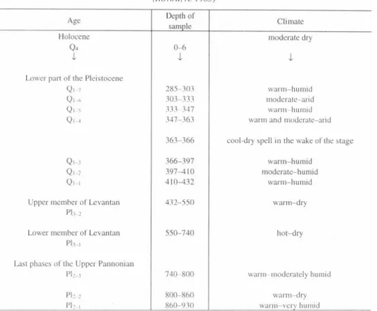
Data referring to warm-dry and hot-dry phases could be found in the borehole profile Jászladány N1 with a total extension of 950 m, at a depth of 432-720 m (RÓNAI, A. 1985, Table 3). In this profile the climate of the warm deciduous forest also indicated by a richness of species (Upper Pannonian substage, between 930-740 m) definitely differs from the semidesert climate of the Lcvantan substage with bleak, unforested vegetation representing a stratigraphic marker.
A warm Mediterranean phase of the formation of terra rossa: the Csarnotanum Geomorphological positions of the typical red clays and reddish clays, their geochemical analyses and conclusions drawn. As far as the dating of desert crusts is concerned, red clays, reddish clays, soil horizons and their geomorphological position
A B
Fig. 3. Results of thermal analyses of carbonaceous-ferrous-siliceous concretions found in a thick sand deposit coverting delta sediments at Mogyoród. Hungary (A) and in Algeria (B)
might be instructive. There are several concepts on the position, spatial distribution, characteristic features of red clay and of red coloured clayey formations both in the international literature (BÜDEL. J. 1950. KUBIENA. W.L. 1956, KUK.LA, G. 1987) and in Hungarian sources (STEFANOVITS. P. 1958, B1DLÓ, G. 1982, BORSY, Z. and SZÖŐR, Gy. 1981, PÉCSI. M. 1985, KRETZOl, M. et til. 1982). In the opinion of some experts, formation of red clays is associated with bauxite formation, however, most of the specialists share Kubiena's (1956) position attributing red clays to two different processes:
Table 3. Clinuitic cycles according to the pollen spectra analysis o f the borehole Jász.ladány N I (RÓNAI, A. 1985)
Age Depth of
sample Climate
Holocene moderate dry
04 0-6
4. i I
Lower part of the Pleistocene
Ql-7 285-303 warm-humid
Ql-r, 303-333 moderate-arid
Ql-5 333-347 warm-humid
Ql-4 347-363 warm and moderate-arid
363-366 cool-dry spell in the wake of the stage
Qi-j 366-397 warm-humid
Ql-2 397-410 moderate-humid
Qi-i 410-432 warm-humid
Upper member of Levantan 432-550 warm-dry
PI 3—2
Lower member of Levantan 550-740 hot-dry
Pl.3-1
Last phases of the Upper Pannonian
Ph-,1 740-800 warm-moderately humid
pi2-2 800-860 warm-dry
pb-. 860-930 warm-very humid
1. Red clays form in humid or dry conditions under the impact of rubefication requiring warming effect;
2. They are the result of lateritisation taking place under permanent humid and warm conditions and leading to bauxite formation.
- On the one hand - from the aspects of landform evolution - red clays should be considered "correlative sediments" providing clues for the reconstruction of past geographic conditions (paleoclimates, soils, and relief-forming processes such as erosion or tectonic movements). They are morphoclimazonal phenopmena and were confined to warm subhumid grove environments on active pediments or on those in the stage of dissection with the prevalence of clayey weathering. In situ formed red clays could eas
ily erode (partly or wholly) owing to increased slope inclination or for other reasons; on gentle slopes it had been accumulating or intercalated by other sediments, whereas in smaller sediment traps soil series with red clays might be formed. Therefore, red clays, as "correlative sediments" should be regarded as indicators of the "climax of pediment conservation".
- On the other hand geomorphological and lithostratigraphic position of mor- phoclimazonal red clays represents a time interval of specific geomorphic conditions. In such a sense loess series can be likewise considered a sequence having formed under semiarid conditions of periglacial zones with forest steppe and steppe vegetation and on the steppe margins of certain deserts during cold phases of the Pleistocene.
Lithostratigraphically red clay formation is underlying the most ancient loesses and loess-like sequences in the Middle Danube Basin, in the southern zone of the Rus
sian Plain and in China. In the ancient loesses there are frequent intercalations of soils of reddish ochre colour, however, none of them are red clays but steppe soils formed under warm-dry, subhumid climates (chestnut or cinnamon soils). These soils are especially typical of the lower Pleistocene loesses on the Loess Plateau in China (e.g. Baoji) and in Central Asia (Tajikistan, Chashmanigar), where ca 20 of these soils are superimposing each other almost directly or with thin loess intercalations making up total thicknesses of 50-80 m. These reddish soils - owing to a low degree of clayey weathering - are paleoecologically different from red clays, and are alternating with thick loess pockets having formed during the Early Pleistocene. Soils represent the moderately subhumid, warm semiarid steppe zone, whereas the interbedded so called warm loesses might have formed under slightly more humid semiarid steppe climates. The time interval of the formation of the latter is between 2.4-1.7 m yr B.P. 1-2 m thick red clay units overlying each other form sequences of more than 30 m thickness. These had formed between >5- 2.4 m yr B.P. In the Middle Danube Basin red clays superimpose the Upper Miocene or Upper Pannonian sequence or more ancient formations.
Its type localities can be studied in several exposures (Gödöllő Hills /Bag/, Hatvan brickyard, Mogyoród, Gyöngyösvisonta /Rókus Hill/, Kulcs, Dunaföldvár, Sek- szárd and Bátaszék brickyards etc.) in Hungary. In boreholes (Pécs-Postavölgy, Szek- szárd, Dunakömlőd, Dunaföldvár, Dunaszekcső, Tass, Tengelic etc.) typical red clays are underlain by Upper Pannonian formations (with bentonite interbedding), whereas the sandy-silty series above them are covered by old loesses. Lithostratigraphically domestic red clays are situated between the Bérbaltavár sand and variegated clays or reddish soils (terra rossa) having developed after the formation of bentonite at Gyöngyösvisonta and found under the oldest loesses. Geomorphologically their formation had followed the development of older pediment surfaces and early Pannonian abrasion terraces and lasted up to the appearance of younger Late Pliocene-Early Pleistocene (Villányium) foothills, in the correlative sediment of which only the debris or redeposited material oi red clays is present as semipedolite. Chronostratigraphically this period - similar to the Chinese red clays - falls in between 4.5-2.5 m yr.
The profile of the Dévaványa core drilling (RÓNAI. A. 1985) was revisited and studied. 10 red clay horizons could be identified between 1000-700m. According to paleomagnetic datings they might have formed between epoch 5 and the Gauss-Gilbert boundary (>5.0-3.3 m yr).
In summary, the formation o f red clays comprise a paleogeographic interval of similar duration as loess formation. Geomorphic evolution and sedimentation, however, had taken place under completely fferent climate morphological conditions. The alter
nation o f loesses and paleosols might he explained by climatic cycles when loess repre
sents the cold phases, while soils the wann ones. In contrast, red clays are the remnants o f warm and humid (subtropical) climate phases. During the warm semiarid interrup
tions no substantial sedimentation occurred. The material was partly washed away even during the interval o f red clay formation , partly contributed to the mineral mass o f subsequently accumulated red clays. In situ red clays witness to climatic fluctuations between warm-humid (subtropical) and warm-semiarid cycles and are found typically in the middle and lower sections o f pediment surfaces.
Weathering products of warm-humid (subtropical) climate are kaolinite- halloysite, whereas under moderately warm-humid and semiarid climates illite- montmorillonite formed and variable carbonate paragenesis took place. These two dif
ferent products (red clays and reddish clays) were separated by SZÖŐR, Gy. (1993) using several geochemical parameters. The changes in the total amount of uranium and thorium (Uekv) and percentage iron dioxide (Fe20 3) is a good example (Fig. 4). The explanation of this regularity refers to the weathering-solving processes controlling mineral paragenesis.
Climatic cycles induced by oscillations of Earth orbit parameters used as expla
nation for Pleistocene cycles by M. MILANKOVIC (23 ka, 100 ka, 400 ka) obviously were valid during the Pliocene and Miocene as well.
Semiarid climatic conditions and the main period of pedimentation
Pediment surfaces (basically different from those developed under Pleistocene periglacial conditions form ed in the Carpathian Basin under semiarid climates.
The typical pediment surfaces - except for cryopediments and cryoglacis - might have formed in three phases and during three different stages.
a) Siimegium (7.5-7.0 Ma B.P.), MN 12 zone. The beginning of pediment formation. Under warm-dry climate geomorphological levels formed at 400-420 m a.s.l.
in the Buda Hills (Széchenyi Hill) and at 300-350 m a.s.l. in the Gerecse Mountains.
This is corroborated by the fauna of the type locality (c.g. Ophisaurus and Gerbillina) with expressed thermoxerotic ecological requirements.
b) Bérbaltavárium was the onset of formation of typical pediment surfaces (6.3-5.0 Ma B.P.), MN 13 zone. Landscapes without woodland, with arid shrubs, some
times grassy, turning into semideserts. The development of pediments can be attributed to processes of areal erosion under semiarid climates with a simultaneous uplift in the surroundings of the Carpathians. The arid semidesert conditions, deficit of moisture are indicated by the absence of travertine horizons. For instance, along the eastern margin of the Buda Hills pediment surfaces were formed between 370-230 m a.s.l. divided into two levels by a travertine horizon at 275 m indicating the renewal of karstic springs: an older one between 370-270 m, of Bérbaltavár age and a younger one (270-230 m) of Villányium age (Fig. 5).
c) Villányium (3.0-2.0 Ma B.P.), MN 16-17 zone, along with the lowering of pediment surfaces formed during the Bérbaltavárium there was a process of formation of
• = Villányium utkv
( p p m ] 10
0 --- --- ---'---•--- --- •--- -—-—-
0 2 t 6 8 X) F«2<>3 1%)
Fig. 4. Separation of the typical Pliocene red clays from the Lower Pleistocene paleosols and sediments based on the U-Th and Fe^O? content (SZÖŐR, Gy. 1993)
atypical pediments. Derasional valleys (filled up by reddish, purplish soils) were cut into their sloping surfaces. Pediments extended over terraced alluvial fans.
The problem of the Tertiary-Quaternary boundary and other possible boundaries It was even earlier that opininons were strongly divided among the experts of Late Neogene and Quaternary concerning the Neogene/Quaternary boundary. The Inter
national Geological Congress (London, 1948) made recommendations that the Plio- cene/Pleistocene boundary should be drawn at the bottom of the Calabrian layers, the first marine sediments containing cold tolerating foraminiferans. Later this was deter
mined by Arias, C. et al. (1980) using paleomagnetic dating at ca 2 Ma B.P.
The Neogene-Quaternary boundary - on the basis of the climatic calendar by MILANKOVIC, M. (1930) and BACSÁK. Gy. (1942) and the phases of Alpine glacia
tion by Penck-Briickner - earlier was established at ca 600 ka B.P. which coincided with the first significant glaciation in the Alps. After there had been found traces of several previous glacial stages (Donau /Eburon/, Biber /Practeigelcn/), the duration of the Pleistocene had been extended, first up to 1.8 Ma, then (by others) to 2.4 and 3.0.
Szabadság hill and Német valley . valley of main horizons of travertine m its surroundings and Sas hill Ördögárok valley Solymár valley Dera creek Danube valley sequences a.s.l.
m
493-472 472-445 445-420
main formation ohases
110-170 IM-1S0 140-115
120
107 T. XII.
T. XI.
T. X.
A . . . .
T.Vfl TV!
I.V
|A J
8 l
°2
«7
Fig. 5. Relationship between the Pannonian abrasional terraces (travertine horizons TXII-TIX). pediment surfaces (H1-H3) and travertines confined to the valleys of the Buda Hilis (TVIII-TI) (SCHEUER, Gy and SCHWEITZER, F. 1972). - a = travertine horizons; b = occurrences; c = TI-TXII - main phases of travertine formation; d = beginning of the formation of erosional valleys and travertines confining to them; e = stadial tectonic movement of the
János Hill and Szabadság Hill with a dominant trend of uplift; f = travertines confining to tectonic movements
This trend was corroborated by the fact that the wake of the Quaternary has always been parallelled with the appearance of the Early Man. This is confirmed by the findings at Diring, Central Siberia at the same time raising the problem of non-tropical origin of man. The age of the Olduvai site is 1.8-1.7 m yr, and that of Coobi Fora (eastern shore of Turkana Lake) is 2.2-2.0 m yr. The cultural layer of the Diring site is estimated by MOCSANOV, I.A. (1983) as 3.2-2.2 m yr. The lower limit of the cultural layer N5 is 3.2-3.1 m yr old (according to the paleomagnetic datings it is 4.2-3.9 Ma) while the age of the upper limit is 2.4-1.8 Ma. Findings of this latter, younger paleolithic site (in Moc- sanov's opininon) shows remarkable similarity to those of Olduvai. By several Russian experts the Early Man of Diring must have lived in a very cold environment. The author of the present paper considers finds at Diring much older than those of Olduvai. The findings bearing sediments were deposited by torrents: sorted sand, gravels with desert varnish (even stone tools are covered with varnish), ventifacts. This sequence in some places is covered by red clays and sand and (Eopleistocene) sediments with intercalated paleosols.
These observations might induce a new approach to the paleoclimatic interpre
tation of the paleogeographic conditions during the Pliocene epoch.
It is conspicuous that the sand series of Diring with findings (61° 12' N latitude, 128° 28' E longitude) containing gravels with desert varnish (serir) and overlain by red clays are very similar to those met by the author in Alaska, USA (63° 54' northern lati
tude, 145° 1 1' western longitude) and in Yukon, Canada (63° 56' northern latitude, 138°
30' western longitude) but without paleolithic findings.
In 1984 the International Commission on Stratigraphy (with a compromise so
lution primarily based on the Olduvai Bed layers) drew the Neogene-Quaternary boundary at 1.8 Ma B.P. This boundary, however, on the basis of geological and biostratigraphic evidence hardly could be linked to any important geohistorical event.
Comparative paleontological investigations carried out earlier by JANOSSY, D. (1979), KRETZOI, M. (1962, 1969) and more recently by KORDOS, L. (1987) have proven an enrichment of fauna succession starting with 1.6-1.5 Ma B.P. and reaching its climax at 1.2 Ma, but deteriorating soon (by 1 Ma). Based on this KORDOS, L. (1987) suggested an event in terrestrial biochronology to be correlated with 1.7-1.6 Ma ob
tained by the studies of marine sediment formations (Olduvai event). Paleontological research has shown that this interval marks a turning point in the development of mam
mal fauna in the Carpathian Basin. Species numbers began to grow at 1.6-1.5 Ma B.P.
which largely corresponds to the lower boundary of the Biharium, while its upper limit is put unambiguously to the Brunhes/Matuyama boundary, i.e. 0.72 Ma (BERGGREN, W.A. et al. 1985). The lowermost part of old loess series named Paks loess (below PD paleosols) can be correlated with the Lower Biharium as well.
Chronologically the older (V/a) member of the Danube terrace V (covered by a younger freshwater limestone than the travertine of Kislángium age) also belong here.
Glacis formation in larger valleys and intramontane basins and dissection of the young
est pediments into interfluvial valleys are confined to this time interval.
In Hungary the Plio-Pleislocene boundary is drawn along the Matuyama-Gauss paleomagnetic boundary, i.e. at 2.4 Ma. At thet time significant tectonic-paleo- geographic-environmental changes occurred in the Carpathian Basin.
By this time dry-warm steppe fauna of the previous Villafranchium (3.5-2.5 Ma B.P.) had become impoverished (JÁNOSSY, D. 1979, KRETZOI, M. 1952, 1969, KORDOS. L. 1988), then disappeared and between 2.4-2.0 Ma B.P. a new faunistic event occurred with the growth of the number of species.Very probably this event makes 2.4 Ma suitable to draw Plio-Pleistocene boundary in the Carpathian Basin. According to RÓNAI. A. (1972, 1985) deep boreholes in the Great Hungarian Plain show a general trend of ther deterioration of the climate, but with interruptions. Beside uneven cooling further fluctuations are created by drier or moister phases. During the period between 2.4-1.8 Ma five climatic intervals could be identified on the basis of the material of boreholes.
There are experts, however, insisting on the lower boundary of the Pleistocene to be drawn along the stage 22 of the oxigén isotope scale. This corresponds to the cold peak of the Pleistocene dated at 0.8 Ma B.P. In the Russian literature this is the Pleisto- ccne-Eopleistocene boundary.
Author’ research has contributed to the solution of the problem of the oldest
"warm loesses" formed at the boundary between the Pliocene and Pleistocene.
The formation below the loess series in non-subsiding hill areas or basin mar
gins as a rule contains hiatuses. In some geomorphological positions, however, where in between terra rossa (reddish soils) or superimposing them and, in some places enclosed by travertines, loesses with loess dolls and loess-like deposits have survived (Szeks/.árd, Bátaszék, Dunaalmás). Found by the author and studied by D. JANOSSY fauna asso
ciation (at Dunaalmás) was situated in the terra rossa underlying loess and loess-like sediments and belonged to the Upper Villányium. These loesses are pale pink, not too thick and do not contain fauna. The oldest loesses of Tajikistan and China are of similar age, but in Alaska even more ancient loesses (3 m yr) can be found.
Studies by author based on investigations into pediment levels, correlative sediments of various age formed on their surface, the oldest terraces and travertine hori
zons, contributed to the establishment of the extent of crustal movements during the Upper Miocene and Pliocene. So, the Buda Hills uplifted 130 m during the Upper Mio
cene, 150-160 m in the Pliocene and 120-130 m in the Pleistocene.
Tectonic movements had shown spatial differentiation during the Pliocene.
They amounted to 100-120 m in the Mecsek Mountains, 50-60 m in the Gerecse and 40-50 m in the Bakony.
REFERENCES
BACSÁK, GY. 1942. Die Wirkung der skandinavischen Vereisung auf die Periglazialzone. - Buda
pest, 86 p.
BERECZ, I.-BOHÁTKA, S.-LANGER. G.-SZÖŐR Gy. 1983. Quadruple mass-spectrometer coupled to Derivatograph. - Internat. Journ. of Mass Spectrometry and Ion Physics. 47. pp. 273-276.
BERGGREN, W. A.-KENT, D. U.-VAN COUVERING, J. A. 1985. Neogene geochronology and chronostratigraphy. - In: SNELLIG, N. J. (ed.) The chronology of the geological record. Geol.
Soc. London. 10. pp. 211-260.
BIDLÓ, G. 1974. Thermal investigation of different types of Hungarian red clays. - Thermal Analysis II. Proced. Fourth 1CTA Budapest, pp. 599-600.
BULLA, B. 1947. Tönkfelszínek (Rumpfflächen.) - Tankönyvkiadó, Budapest, 554 p.
BULLA, B. 1954b. A szilárd kéreg domborzata fejlődésének területi rendszere. - Magyar Tudományos Akadémia Társadalmi-Történeti Tudományok Osztályának Közleményei. Budapest.
BÜDEL, J. 1950. Das System der klimatischen Morphologie. - Deutscher Geographentag, München.
1948. Landshut. Amt für Landeskunde, 36 p.
CHOLNOKY, J. 1918. A Balaton hidrográfiája. - Balaton. Tud. Tanúim. Eredményei. I. köt. II. rész.
Magyar Földr. Társ. Balaton Biz. Budapest, 316 p.
DANK, V.-JÁMBOR Á. 1987. A magyarországi kiskunsági (pannóniai s. str.) emeletbeli képződmé
nyek általános földtani jellegei. - Földt. Int. Évk. XIX. pp. 9-18.
FÁBIÁN, Sz.-KOVÁCS, 1 - VARGA, G. 1999. Újabb sivatagi fénymázas kérgek Magyarországról. - Földr. Ért. elfogadott közlemény.
HARLAND, W. B. et cd. 1982. A geologic time-scale Cambridge, Univ. Press. 130 p.
HAQ, B. U.-HARDENBOL, J.-VAIL, P. R. 1987. Chronology of Fluctuating Sea Levels since the Triassic Science Vol. 235. pp. 1156-1167.
JÁNOSSY, D. 1979. A magyarországi pleisztocén tagolása gerinces faunák alapján. - Akad. Kiadó, Bp. 207 p.
JUX, U. Zusammensetzung und Ursprung von Wüstenglasern aus der Grossen Sandsee-Ägyptens. - Zeitschr. Deutsch. Geol. Ges. 134. pp. 521-553.
KORDOS, L. 1987a. Neogene Vertebrate Biostratigraphy in Hungary. - Földt. Int. Évi .lel. 1984-ről.
pp. 523-553.
KORDOS, L. 1988. A spalax nemzetség (Rodentia) európai megjelenése és a plio-pleisztocén határkérdés. - Földt. Int. Évi Jel. 1986-ról. pp. 469-491.
KRETZOI, M. 1942. Eomellivora von Polgárdi and Csákvár. - Földt. Közi. 72. pp. 318-323.
KRETZOI, M. 1952. A polgárdi Hipparion-fauna ragadozói. - Földt. Int. Évk. 40. (3.). pp. 1-35.
KRETZOI, M. 1961. A diósdi gerinces fauna és a miocén-pliocén határ kérdése. - Földt. Közi. 91. pp.
208-214.
KRETZOI. M. 1969. A magyarországi quarter és pliocén szárazföldi sztratigráfiájának vázlata. - Földr. Közi. 17. (93.). 2. pp. 197-204.
KRETZOI, M. 1982. Fontosabb szórványleletek a MÁF1 Gerinces-gyűjteményében (7. közlemény). - Földt. Int. Évi Jel. 1980-ról. pp. 385-393.
KRETZOI. M. 1987a. A Kárpát-medence pannóniai (s. 1.) terresztrikus gerinces biokronológiája. - Földt. Int. Évk. LXIX. pp. 393-422.
KUBIENA, W. L. 1958. The classification of soils. - J. of S. Sc. Vol. 9. N° 1. Pp. 9-19.
LÓCZY, L. 1890. Geológiai megfigyelések és eredmények K-Ázsiában. Gróf Széchenyi Béla kelet
ázsiai útjának (1877-1880) tudományos eredményei. 1. köt. Budapest
LÓCZY, L. 1913. A Balaton környékének geológiai képződményei és ezeknek vidékek szerinti telepe- dése. - A Balaton Tud. Tanúim. Eredményei. 1. Köt. I. rész, 1 sz. - Magyar Földr. Társ. Bala
toni Biz. Bp.. 617 p.
MILANKOVIC, M. 1930. Matematische Klimalehre und astronomische Theorie der Klimaschwankugen. - In: Koppen. W. - Geiger. R. (eds.) Handbuch der Klimatologie. I. Ber
lin, Gebr, Borntrueger, pp. 1-176.
PÉCSI, M. 1980. A Pannóniai-medence morfogenetikája. - Földr. Ért. 29. Pp. 105-127.
PÉCSI, M. 1985. The Neogene red clays of the Carpathian Basin. - Studies in Geogr. In Hung. 19.
Akad. Kiadó, Budapest, pp. 89-98.
POGÁCSÁS, GY.-JÁMBOR, Á.-MATTICH, R. E.-ELSTON, D. P.-HÁMOR, T.-LAKATOS, L .- LANTOS, M.-SIMON, E.-VAKARCS, G.-VÁRKONYI, L.-VÁRNAI, P. 1989. A nagyalföldi neogén képződmények kronosztratigráfiai viszonyai szeizmikus és paleomágneses adatok összevetése alapján. - Magyar Geofizika. XXX. Évf. 2-3. pp. 41-62.
RÓNAI, A. 1985. Limnic and terrestrial sedimentation and the N/Q boundary in the Pannonian Basin.
- In: Problems o f the Neogene and Quaternary. Studies in Geogr. In Hung. 19. Akad. Kiadó, Budapest, pp. 21-49.
SCHWEITZER, F. 1977. On late Miocene-early Pliocene desert climate in the Carpathian Basin. - Geomorph. N. F. Suppi. Bd. 110. pp. 37-43.
SCHWEITZER, F. 1994. A Kárpát-medence belsejének későneogén domborzatformálódása (Landform evolution in the inner parts of the Carpathian Basin during the late Neogene.). - D. Sc.
Dissertation, manuscript, Geogr. Res. Inst. Hung. Acad, Sei., Budapest, 170 p.
STEFANOVITS, P. 1958. Vörösagyagok előfordulása és tulajdonságai Magyarországon. - MTA Agrártudományi Oszt. Közi. pp. 15-29.
STEININGER. F. F.-SENES, J.-KLEEMANN, K.-ROGL, F. 1985. Neogene of the Mediterranean Tethys and Paratethys (Stratigraphie correlation tables and sediment distribution maps). - In
stitute of Paleontology, University Press of Vienna, 1. 189 p„ 2. 254 p.