Strategic Planning
Effective Cooperation for Spatial Planning Across Boundaries
Richard Blyth
1Abstract
City regions require spatial planning over their whole territory in order to achieve better development outcomes for people. However, city regions are usually characterised by fragmented local governance, and there is a need to overcome this through cooperation.
This paper highlights some elements of good practice to achieve this improvement, including the use of digital technology.
Keywords: spatial planning, cities, municipalities, multi-level governance
1 Royal Town Planning Institute, United Kingdom; richard.blyth@rtpi.org.uk
I. Introduction
There is increasing recognition that a nation’s prosperity is dependent on its cities’ success. In many countries cities produce more output per worker than average and more output within growing economic sectors. They can also more be environmentally sustainable, with for example UK cities producing 32 percent less carbon emissions than non-city areas (Centre for Cities 2014).
However, in addition the functioning of cities depends on relationships with areas immediately surrounding them.
Geographers call these ‘functional
economic areas’. They are also known as ‘city regions’.
Relationships within these areas include obvious ones such as commuting, but also business- to-business relationships, and connections between major institutions such as universities and hospitals and the areas in which they are located.
The UN New Urban Agenda (UN 2017) was signed in Quito in 2016. Signatories committed to promoting urban spatial frameworks, supporting compactness, density, polycentrism and mixed use, planning at the scale of city-regions and metropolitan areas, and promoting equitable growth.
¯¯¯¯¯¯¯¯¯¯¯¯¯¯¯¯¯¯¯¯¯¯¯¯¯¯¯¯¯¯¯¯¯¯¯¯¯¯¯¯¯¯¯¯¯¯¯¯¯¯¯¯¯¯¯¯¯¯¯¯¯¯¯¯¯¯¯¯¯¯¯¯¯¯¯¯¯¯¯¯¯¯¯¯¯¯¯¯¯¯¯¯¯¯¯¯¯¯¯¯¯¯¯¯¯¯¯¯¯¯¯¯¯¯¯¯¯¯¯¯¯¯¯¯
¯¯¯¯¯¯¯¯¯¯¯¯¯¯¯¯¯¯¯¯¯¯¯¯¯¯¯¯¯¯¯¯¯¯¯¯¯¯¯¯¯¯¯¯¯¯¯¯¯¯¯¯¯¯¯¯¯¯¯¯¯¯¯¯¯¯¯¯¯¯¯¯¯¯¯¯¯¯¯¯¯¯¯¯¯¯¯¯¯¯¯¯¯¯¯¯¯¯¯¯¯¯¯¯¯¯¯¯¯¯¯¯¯¯¯¯¯¯¯¯¯¯¯¯¯¯¯¯¯
Article 96 is clear that these challenges require action at a range of scales. While some can be addressed at the level of neighbourhood, local areas and towns/cities, many require a coordinated approach at a much wider scale: entire city-regions and metropolitan areas.
The question of suitable subnational government is of importance across Europe with the European Commission requiring the involvement of different tiers of government in its funding programmes.
However, in many countries around the world the political facts of such relationships do not reflect the economic and social realities on the ground. Such is the increasing significance of cities – and particular the growing understanding that cities compete with each other around the world, that such political difficulties are becoming matters of national priority.
The OECD has identified five issues that must be tackled (Thompson, W. 2013):
⊕ finance and fiscal policies;
⊕ lack of joined-up governance;
⊕ ‘human’ policies rather than spatial policies;
⊕ governance for functional geographies;
⊕ institutional structure and frameworks.
These are issues of core concern to spatial planners everywhere. People-oriented agendas such as education, skills, housing, health and social services have usually been driven by national institutions concerned to ensure uniform provision. However this frequently results in solutions which are poorly adapted to local urban contexts (RTPI 2014b).
A further critical question is the need for different layers of government (national, city and neighbourhood) to be properly empowered for their respective tasks and to work together effectively in multi-level governance (Charbit, C. 2011; RTPI 2014a). It is equally important for the different sectors with responsibility for policies in urban areas to work together within those places. As far as citizens are concerned, what matters is their entire experience, not the administrative convenience of different silos. This issue is a particular challenge where individual sectors have pursued policies of large scale privatisation.
The direct solution of simply redrawing boundaries to reflect functional geography is rarely adopted as it is unpopular, expensive and difficult to get right (Clark, G. – Clark, G. 2014).
On the other hand the imposition of a two tier metropolitan system
¯¯¯¯¯¯¯¯¯¯¯¯¯¯¯¯¯¯¯¯¯¯¯¯¯¯¯¯¯¯¯¯¯¯¯¯¯¯¯¯¯¯¯¯¯¯¯¯¯¯¯¯¯¯¯¯¯¯¯¯¯¯¯¯¯¯¯¯¯¯¯¯¯¯¯¯¯¯¯¯¯¯¯¯¯¯¯¯¯¯¯¯¯¯¯¯¯¯¯¯¯¯¯¯¯¯¯¯¯¯¯¯¯¯¯¯¯¯¯¯¯¯¯¯¯¯¯¯¯
is often resisted by existing lower tiers. The most common solution around the world is one form or other of innovation whereby local governments enter into partnerships. Whilst arising from a wider discussion within public policy, this is an issue of profound importance for urban planning in particular. Many matters such as managing river basins, planning renewable energy, providing sufficient and affordable housing across a commuting area, ensuring transport links are sufficient, responding to climate change and guiding strategic investment in health, education and training need coordination across a wider area than a single local authority.
II. Strategic Planning Best Practice
Whilst there is some good practice in some countries and in some places, this is not happening as much as it should. What is needed is strategic planning i.e. planning across municipal boundaries. The Royal Town Planning Institute looked into this issue to try to identify the success factors in making it work.
While there are technical, global and even national reasons to do strategic planning well, a key issue is when people in localities
get the message that places benefit mutually from working together.
Two places where this has happened successfully are Lille Metropole in France and Greater Manchester in England.
The Métropole Européenne de Lille in Northern France is an area with a large number of separate local authorities. It faced serious industrial decline in the 1970s. This affected in particular the large towns of Roubaix and Tourcoing, which had rising unemployment as a result of competition to their native textile industries from outside Europe. The solution adopted by the conurbation was to promote Lille city – at the centre of the conurbation – as the leading location for new types of industries.
However, creating new jobs in Lille would not necessarily benefit the communities where the jobs were most being lost. So the other communities were enabled to benefit through the creation of excellent public transport which enabled citizens to participate in the growth of Lille. A 32-km metro line was built from Lille to Roubaix and Tourcoing making Roubaix only 20 minutes from Lille centre. In addition the Métropole funded city centre renewal and housing renewal projects there.
But now, having secured a firm start in one location, the wider city
¯¯¯¯¯¯¯¯¯¯¯¯¯¯¯¯¯¯¯¯¯¯¯¯¯¯¯¯¯¯¯¯¯¯¯¯¯¯¯¯¯¯¯¯¯¯¯¯¯¯¯¯¯¯¯¯¯¯¯¯¯¯¯¯¯¯¯¯¯¯¯¯¯¯¯¯¯¯¯¯¯¯¯¯¯¯¯¯¯¯¯¯¯¯¯¯¯¯¯¯¯¯¯¯¯¯¯¯¯¯¯¯¯¯¯¯¯¯¯¯¯¯¯¯¯¯¯¯¯
region has successfully developed a wider spread of new jobs focussed round seven centres, not just in Lille, ranging from health-based industries (Eurasanté) through to textile innovation (Roubaix) and logistics (Tourcoing). These centres form a strategy of clusters that deal with all the elements in the supply chain from design and training to production and retail (Columb, C.
2007).
A critical factor is the formulation of the Comité Grand Lille in 1993 comprising business, politicians and academics to bid (unsuccessfully) to host the 2004 Olympic Games and then (successfully) for the 2004 European Capital of Culture. This drew not only different sectors together but also ensured that all parts of the city region participated in the benefits of the bids.
Greater Manchester is an agglomeration of 2.8 million people in Northern England. It has a long tradition of voluntary cooperation through the Association of Greater Manchester Authorities (AGMA) model of voluntary collaboration between local authorities through a Joint Committee. This has been superseded by Greater Manchester Combined Authority (GMCA) which is a statutory (legal) body with its functions set out in the UK Local Democracy, Economic
Development and Construction Act 2009 in which each of the 10 municipalities has an equal vote.
The GMCA was further amended under the Cities and Local Government Devolution Act 2016 to allow for a directly-elected mayor for whole city region for the first time. The Mayor now joins the GMCA as its 11th member. He is responsible for a £300 million housing investment fund and for the creation of a spatial planning framework.
One of the key issues facing an area such as Greater Manchester is the question of winners and losers and the greater good. How can those supporting greater cooperation convince all players that it is in their interests to work together, when that can mean local areas missing out?
The TANGO research for the European Spatial Observatory Network (ESPON) has investigated the way in which Greater Manchester has become a concept which authorities other than Manchester City (which is little more than one fifth of the total population) can buy into (ESPON 2013). The first is in establishing local understanding of the concept:
‘Whilst most of those living within the territory covered by the combined authority would have very little understanding of the nature and role of the GMCA there
¯¯¯¯¯¯¯¯¯¯¯¯¯¯¯¯¯¯¯¯¯¯¯¯¯¯¯¯¯¯¯¯¯¯¯¯¯¯¯¯¯¯¯¯¯¯¯¯¯¯¯¯¯¯¯¯¯¯¯¯¯¯¯¯¯¯¯¯¯¯¯¯¯¯¯¯¯¯¯¯¯¯¯¯¯¯¯¯¯¯¯¯¯¯¯¯¯¯¯¯¯¯¯¯¯¯¯¯¯¯¯¯¯¯¯¯¯¯¯¯¯¯¯¯¯¯¯¯¯
was a strong cultural affinity to the notion of a Manchester city region.
One of the drivers for the regional affinity may have been the various high profile city region projects [such as] … the Commonwealth Games and the failed Olympic bid
…’
It is interesting that in both Lille and Manchester sporting or cultural events have played a big role in drawing civil society together across a wider city region. This can form the basis of the cooperation needed to tackle difficult questions such as decisions on the location of housing growth. In the case of Greater Manchester this will be tested in 2018 with the publication of the draft spatial framework.
Strategic planning should be locally designed. England tried a top down approach of imposing nine official regions and it did not survive politically. On the other hand, where arrangements for cross-border planning are designed locally they tend to last longer.
For example a long standing arrangement called Partnership for Urban South Hampshire among the cities of the South Coast in England including Portsmouth and Southampton and their surrounding municipalities has for some time now made strategic agreements around how much housing growth should be allocated to each area to enable the cities to grow.
Strategic planning should cover a wider range of policy areas.
In the UK there has been a legacy of focussing on housing alone as a policy area. This means that other critical issues are neglected.
However there has been good practice in certain cases where a broad approach has been taken.
For example the joint planning arrangements for the Glasgow and Clyde Valley metropolitan area were originally established in 1996 for the production of a structure plan followed local government reorganisation, but were harnessed to provide the spatial planning context for a range of action programmes in the fields of economic development, urban renewal, health promotion, housing, transportation and the environment. As a result a series of complementary common perspectives were developed in an attempt to re-engage with agencies and partners following local government reorganisation and to bridge the gap in economic development, transport and the environment created by the termination of Strathclyde Regional Council. The common perspectives:
⊕ set out formally a common understanding of issues, for example, though a common SWOT analysis for their particular field of action;
¯¯¯¯¯¯¯¯¯¯¯¯¯¯¯¯¯¯¯¯¯¯¯¯¯¯¯¯¯¯¯¯¯¯¯¯¯¯¯¯¯¯¯¯¯¯¯¯¯¯¯¯¯¯¯¯¯¯¯¯¯¯¯¯¯¯¯¯¯¯¯¯¯¯¯¯¯¯¯¯¯¯¯¯¯¯¯¯¯¯¯¯¯¯¯¯¯¯¯¯¯¯¯¯¯¯¯¯¯¯¯¯¯¯¯¯¯¯¯¯¯¯¯¯¯¯¯¯¯
⊕ provided a spatial interpretation of the policies of the Agencies in question;
to set the Development Plan’s polices within a wider context of Joint Action;
⊕ demonstrated that the need for economic development requires not only new development sites but also linkage to Job Training Programmes; and
⊕ defined key areas of joint action required to implement the strategy.
The core policies of the 2000 Glasgow and Clyde Valley [Structure] Plan were linked to delivery mechanisms. Local plans were as a result prepared in tandem, such that seven of the eight councils had finalised or adopted plans within a year of the approval of the 2000 Structure Plan. The 2005 update of the Structure Plan sought to extend common perspectives into thematic
‘Joint Action Programmes’ which link the Plan more clearly to the programmes of the implementation agencies and to delivery mechanisms. The effectiveness of the Plan was reflected in:
⊕ Promoting Urban Renewal:
Since 1996 there has been a net annual reduction in vacant land of 106 ha. The three Flagship Initiatives identified
through the Plan were taken up by the development agencies, now have been embedded in the National Planning Framework as key priorities – the Clyde Gateway, Clyde Waterfront and Ravenscraig.
These collectively seek to promote 25 thousand houses and a comparable number of jobs.
⊕ Widening Strategic
Cooperation: The collective action achieved through the joint strategic planning arrangements encouraged wider collaboration in sectoral policy areas. As a result, the Joint Committee was used as the mechanism for extending the level of cooperation between councils by preparing complementary Joint Transport and Greenspace Strategies. This has resulted in the establishment of dedicated teams to deliver these strategies and associated funding streams.
The Development Plan was also one of the core source documents for the City Vision Report which formed the basis for a strategic Community Planning Partnership across all eight council areas in the metropolitan area.
¯¯¯¯¯¯¯¯¯¯¯¯¯¯¯¯¯¯¯¯¯¯¯¯¯¯¯¯¯¯¯¯¯¯¯¯¯¯¯¯¯¯¯¯¯¯¯¯¯¯¯¯¯¯¯¯¯¯¯¯¯¯¯¯¯¯¯¯¯¯¯¯¯¯¯¯¯¯¯¯¯¯¯¯¯¯¯¯¯¯¯¯¯¯¯¯¯¯¯¯¯¯¯¯¯¯¯¯¯¯¯¯¯¯¯¯¯¯¯¯¯¯¯¯¯¯¯¯¯
⊕ Harnessing Additional Resources: Similarly, the 2000 Plan was adopted as the spatial development
framework which
underpinned the European Regional Development Fund single programme document (1999–2006) and was the basis for a GRO Grant programme of ‘gap funding’ for private housing on brownfield sites. It was also a core source document used to harness £70 million additional resources through the Scottish Government’s Cities Growth Fund.
Subsequently, the Plan was used as the basis of a bid for a
£60 million five-year rolling programme for the treatment of vacant and derelict land and to kick start a £50 million multi-agency Greenspace partnership.
Successful strategic planning needs to involve business. We have found that where business has been kept out of decisions on the number of homes in an area, the problem is that business growth can outstrip the capacity of the local labour force to accommodate it.
In England Local Enterprise Partnerships (LEPs) were established in 2010 to replace
Regional Development Agencies.
The coalition government required them to be led by the private sector and for them to display a strong entrepreneurial aspect. This aim appears to have succeeded, with the look and feel of LEPs being more business-focussed and less official than RDAs. They have also undertaken a great deal of activity given a small input of public money. (However questions remain concerning the ability of leading business people to maintain long- term major voluntary commitments on top of pressing day jobs.).
Under current arrangements there is no obligation on LEPs to undertake any strategic spatial planning per se. Their principal achievement has been in animating the business community to effectively undertake a vast amount of voluntary activity and to confront and process strategic planning matters such as skills, transport and land availability for housing and employment purposes. However LEPs do have a strong potential to establish what the business voice is within a city region or county. This is a valuable stepping stone towards a strong business input into strategic spatial planning which can provide a firm backdrop to plan making by individual councils. However, they are not a substitute for democratic decision making.
¯¯¯¯¯¯¯¯¯¯¯¯¯¯¯¯¯¯¯¯¯¯¯¯¯¯¯¯¯¯¯¯¯¯¯¯¯¯¯¯¯¯¯¯¯¯¯¯¯¯¯¯¯¯¯¯¯¯¯¯¯¯¯¯¯¯¯¯¯¯¯¯¯¯¯¯¯¯¯¯¯¯¯¯¯¯¯¯¯¯¯¯¯¯¯¯¯¯¯¯¯¯¯¯¯¯¯¯¯¯¯¯¯¯¯¯¯¯¯¯¯¯¯¯¯¯¯¯¯
LEPs have produced Strategic Economic Plans. These are business-based documents. But in many areas LEPs have recognised that a good housing supply is essential for local growth. For example the Lancashire Enterprise Partnership’s Strategic Economic Plan (LEP 2014) includes:
‘A strategic transport programme seeking £195.7 million in competitive Growth Deal funding to release the economic and housing growth potential of Preston, East Lancashire, Lancaster and Skelmersdale in West Lancashire, …’
The Lancashire LEP also ensures strong linkage between housing and economic growth and transport investment:
‘4.4 Ensuring major transport projects and investments are fully aligned with the delivery of key economic and housing growth priorities across Lancashire’
This business-led approach to subregional economic planning has operated consistently with the approach being adapted to land-use planning:
‘7.139 To maximise opportunities local partners are currently undertaking reviews of Green Belt to accommodate new housing development and local
plans are adopting a strongly market-facing approach to site allocations.’
Three councils in ‘Central Lancashire’ (Preston, South Ribble and Chorley) have produced a single joint core strategy adopted in 2012 which makes all the housing allocations in broad principle. It is being supplemented by detailed plans in smaller areas around the three boroughs.
A further success factor is the buy-in from municipal politicians.
TAYplan Strategic Development Planning Authority is a partnership with the purpose of preparing, monitoring and reviewing the Strategic Development Plan for the Dundee and Perth City Region in Scotland. Effective partnership working is at the heart of how TAYplan operates. Whilst Scottish planning legislation allows a constituent Planning Authority within a strategic development planning area to submit its own strategy should agreement not be reached, such a scenario is not on TAYplan’s agenda. TAYplan is governed by a Joint Committee made up of three local councillors from each of the four constituent councils. The chair rotates annually and meetings are held 2–3 times each year. The elected members use the opportunity of the Joint Committee to informally discuss
¯¯¯¯¯¯¯¯¯¯¯¯¯¯¯¯¯¯¯¯¯¯¯¯¯¯¯¯¯¯¯¯¯¯¯¯¯¯¯¯¯¯¯¯¯¯¯¯¯¯¯¯¯¯¯¯¯¯¯¯¯¯¯¯¯¯¯¯¯¯¯¯¯¯¯¯¯¯¯¯¯¯¯¯¯¯¯¯¯¯¯¯¯¯¯¯¯¯¯¯¯¯¯¯¯¯¯¯¯¯¯¯¯¯¯¯¯¯¯¯¯¯¯¯¯¯¯¯¯
other cross boundary projects and issues.
The Strategic Development Plan takes account of the Single Outcome Agreements each council has agreed with the Scottish Government. TAYplan has a role in assisting Government to achieve national outcomes, especially those related to planning as set out in the National Planning Framework and Scottish Planning Policy. Therefore, the TAYplan outcomes are aligned to national planning outcomes and those of the constituent councils.
The partnership has to bring together different political groups and ensure buy-in and ownership of the strategic vision, outcomes and spatial strategy. In doing so it is important to have effective communication, briefing elected members regularly, discussing the key issues ahead of committee meetings and making changes to best ensure that the plan meets political, as well as other, needs.
The Strategic Development Plan was approved in October 2017. However proposals to change Scottish spatial planning legislation are currently before the Parliament (Scottish Parliament 2017). They include the abolition of strategic development plans.
While that could in one sense be regarded as a setback, it could have the advantage of enabling the kinds
of cooperation in the TAYplan to be applied to a wider range of areas and for these areas to have a greater influence in the creation of national Scottish planning frameworks.
Finally, a key principle for effective strategic planning is forming practical relationships with adjoining areas for strategic planning. Within England there is a potential axis of rapid growth between the university cities of Oxford and Cambridge.
Arrangements for strategic planning in Cambridge and Oxford city regions are well developed (Cambridgeshire and Peterborough Combined Authority 2018; Ministry of Housing Communities and Local Government 2018), but there is a need for cooperation between them, which would need to cover the area around Milton Keynes (a planned new city begun in 1970) as well. There have been some recent suggestions regarding how this might be achieved (e.g. National Infrastructure Commission 2017).
III. Smart City or Smart City Region?
A successful smart city means knowing what information you want, being able to access it, and then having the governance
¯¯¯¯¯¯¯¯¯¯¯¯¯¯¯¯¯¯¯¯¯¯¯¯¯¯¯¯¯¯¯¯¯¯¯¯¯¯¯¯¯¯¯¯¯¯¯¯¯¯¯¯¯¯¯¯¯¯¯¯¯¯¯¯¯¯¯¯¯¯¯¯¯¯¯¯¯¯¯¯¯¯¯¯¯¯¯¯¯¯¯¯¯¯¯¯¯¯¯¯¯¯¯¯¯¯¯¯¯¯¯¯¯¯¯¯¯¯¯¯¯¯¯¯¯¯¯¯¯
arrangements in place that allow you to deploy it in pursuit of wider objectives. This should be driven by city leaders and planners in partnership with the private sector, rather than cities simply reacting to new technology as it disrupts the urban environment. And a
‘city’ needs to be regarded as a
‘city region’ in order to be able to function.
This is the focus of a new project at the Royal Town Planning Institute, which looks at the link between smart cities and strategic planning across boundaries. What does the rise of smart cities mean for our ability to tackle larger-than- local issues, and how new types of data and information are being used to support governance at the city- region scale to:
How can planners use data, technology and new ways of working to make city-regions more productive, equitable and sustainable?
⊕ develop plans which cross geographies and sectors resolving conflicting agenda between municipalities;
⊕ coordinate growth with low- carbon infrastructure;
⊕ measure wider social, environmental and economic impacts;
⊕ engage the public in strategic decision-making.
IV. Practical Examples of Smart City Regions
IV.1. Monitoring
The debate around planning and housing in England tends to focus on three criteria: the number of houses granted permission, the speed at which they are built, and the affordability of the finished product. There is a wealth of data on each of these metrics, and these are increasingly used to measure the effectiveness of the planning system.
However, while these are important criteria, they form just part of the picture. Planning is about delivering sustainable development, not just housing numbers. That is why the National Planning Policy Framework (NPPF) includes a wide range of economic, social and environmental objectives which include boosting economic growth, promoting sustainable transport, tackling climate change and improving public health.
Planning can help to deliver these objectives by looking at the big picture and ensuring that new development supports sustainable settlement patterns and urban form.
But when it comes to measuring progress, there is little public data and spatial analysis to show the location and scale of new development. Without this data,
¯¯¯¯¯¯¯¯¯¯¯¯¯¯¯¯¯¯¯¯¯¯¯¯¯¯¯¯¯¯¯¯¯¯¯¯¯¯¯¯¯¯¯¯¯¯¯¯¯¯¯¯¯¯¯¯¯¯¯¯¯¯¯¯¯¯¯¯¯¯¯¯¯¯¯¯¯¯¯¯¯¯¯¯¯¯¯¯¯¯¯¯¯¯¯¯¯¯¯¯¯¯¯¯¯¯¯¯¯¯¯¯¯¯¯¯¯¯¯¯¯¯¯¯¯¯¯¯¯
is it hard to understand whether planning policy is really delivering sustainable development?
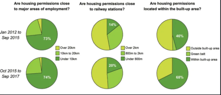
Given the significance of these spatial relationships, the RTPI commissioned Hatch to help us to gain a better understanding of changing settlement patterns and urban form in twelve fast-growing English city-regions. Using data from EGI the study mapped planning permissions for over 226 thousand new houses granted between 2012 and 2017, focusing on major schemes of 50 or more units. It measured the size of each scheme and its relationship to the existing built-up area, and analysed
proximity to major employment clusters and key public transport nodes – just some of the factors that make for a sustainable location.
The study was divided into two rounds. The first ran from January 2012 to September 2015, and the second from October 2015 to September 2017. Across both studies, we found that new housing is being located relatively close to jobs, with 74 percent of permissions within 10 km of a major employment cluster. However, we found that over half of the houses permitted are not within easy walking or cycling distance of a railway, metro or underground station (Figure 1).
Figure 1: Monitoring the Location of Development in England Source: RTPI
IV.2. Infrastructure for sites
Greater Manchester is making moves to use data in exciting new ways. The Combined Authority has an Open Data Infrastructure Map
which helps to show how proposed new sites for development are served by different types of infrastructure – so you can easily where development would be the most sustainable.2
2 https://mappinggm.org.uk/gmodin/ – 2018. 09. 14.
¯¯¯¯¯¯¯¯¯¯¯¯¯¯¯¯¯¯¯¯¯¯¯¯¯¯¯¯¯¯¯¯¯¯¯¯¯¯¯¯¯¯¯¯¯¯¯¯¯¯¯¯¯¯¯¯¯¯¯¯¯¯¯¯¯¯¯¯¯¯¯¯¯¯¯¯¯¯¯¯¯¯¯¯¯¯¯¯¯¯¯¯¯¯¯¯¯¯¯¯¯¯¯¯¯¯¯¯¯¯¯¯¯¯¯¯¯¯¯¯¯¯¯¯¯¯¯¯¯
IV.3. Natural environment The Royal Town Planning Institute is working with Birmingham and Northumbria Universities who are developing a tool which can assess the long- term impact of development on ecosystem services, based on a comprehensive dataset of ecological data. This is being used to shape development proposals so that they deliver net gains to natural capital, which helps to get local communities (who might otherwise oppose development) on board. It is of particular value on the urban fringe.3
The Climate Just web tool combines national datasets on social vulnerability with places which are at risk of flooding and overheating.
This creates maps of people and places which could be particularly affected by climate change, and could be used to target investment in preventative measures like natural flood management.4
IV.4. Public engagement Combined authorities will need to find new ways of engaging the public in complex decisions
3 ecosystemsknowledge.net/natural- capital-planning-tool-ncpt 4 climatejust.org.uk
which transcend the local or neighbourhood level. New tools, apps and games offer opportunities to reach out in different ways.
Plymouth City Council created an interactive online version of their Local Plan which allowed users to comment on policies using social media. The Place Standard, developed in partnership between the Scottish Government, NHS Scotland and Architecture & Design Scotland, offers a consistent way to evaluate the physical and social qualities of a particular place.5
V. Conclusion
A new focus on ‘smart city- regions’ would seek solutions which benefit not only major cities, but also their surrounding towns, villages and rural areas, working towards broader economic, social and environmental objectives of planning. In the current context of English devolution, there is a valuable opportunity existing to direct the technological innovation of the smart city agenda towards the specific challenges that combined authorities (and other groups of local authorities) face when planning across geographical and sectoral boundaries (Figure 2).
5 placestandard.scot
¯¯¯¯¯¯¯¯¯¯¯¯¯¯¯¯¯¯¯¯¯¯¯¯¯¯¯¯¯¯¯¯¯¯¯¯¯¯¯¯¯¯¯¯¯¯¯¯¯¯¯¯¯¯¯¯¯¯¯¯¯¯¯¯¯¯¯¯¯¯¯¯¯¯¯¯¯¯¯¯¯¯¯¯¯¯¯¯¯¯¯¯¯¯¯¯¯¯¯¯¯¯¯¯¯¯¯¯¯¯¯¯¯¯¯¯¯¯¯¯¯¯¯¯¯¯¯¯¯
High Smart City Smart City-Region
Coordination across sectors Local authority Combined authority
Low Planning across geographical boundaries High Figure 2: Smart City-Regions
Source: RTPI
VI. References
Cambridgeshire and Peterborough Combined Authority 2018:
Cambridgeshire and Peterborough Strategic Spatial Framework Centre for Cities 2014: Cities Outlook 2014. – London: Centre for
Cities
Charbit, C. 2011 Governance of Public Policies in Decentralised Contexts:
The Multi-Level Approach. – OECD Regional Development Working Papers 04.
Columb, C. 2007: Making Connections: Transforming People and Places in Europe. – York: Joseph Rowntree Foundation
Clark, G. – Clark, G. 2014: Nations and the Wealth of Cities. – Centre for London
ESPON 2013: Territorial Approaches for New Governance Applied Research 21. 01. – Case Study Report, Reinventing regional territorial governance. – Greater Manchester Combined Authority LEP 2014: Lancashire Strategic Economic Plan: A Growth Deal for the
Arc of Prosperity. – Lancashire, Preston: Lancashire Enterprise Partnership
Ministry of Housing Communities and Local Government 2018:
Oxfordshire Housing Deal. – London: UK Government
National Infrastructure Commission 2017: Partnering for Prosperity: A New Deal for the Oxford-Milton Keynes-Cambridge Arc. – London:
National Infrastructure Commission
RTPI 2014a: Making Better Decisions for Places. – London: Royal Town Planning Institute. – Planning Horizons Series 5.
RTPI 2014b: Thinking Spatially. – London: Royal Town Planning Institute.
– Planning Horizons Series 1.
¯¯¯¯¯¯¯¯¯¯¯¯¯¯¯¯¯¯¯¯¯¯¯¯¯¯¯¯¯¯¯¯¯¯¯¯¯¯¯¯¯¯¯¯¯¯¯¯¯¯¯¯¯¯¯¯¯¯¯¯¯¯¯¯¯¯¯¯¯¯¯¯¯¯¯¯¯¯¯¯¯¯¯¯¯¯¯¯¯¯¯¯¯¯¯¯¯¯¯¯¯¯¯¯¯¯¯¯¯¯¯¯¯¯¯¯¯¯¯¯¯¯¯¯¯¯¯¯¯
Scottish Parliament 2017: Planning (Scotland) Bill. – Policy Memorandum, 04. 12.
Thompson, W. 2013: Achieving Policy Coherence for Cities. – OECD presentation at workshop on Colombia’s Misión de Ciudades, Bogotá UN 2017: New Urban Agenda. – United Nations