COMPASS – Comparative
Analysis of Territorial Governance and Spatial Planning Systems in
Europe
Applied Research 2016-2018
Final Report - Additional Volume 6
Case Studies Report
Final Report - Additional Volume 6 – Case Studies Report
This applied research activity is conducted within the framework of the ESPON 2020 Cooperation Programme.
The ESPON EGTC is the Single Beneficiary of the ESPON 2020 Cooperation Programme. The Single Operation within the programme is implemented by the ESPON EGTC and co-financed by the European Regional Development Fund, the EU Member States and the Partner States, Iceland, Liechtenstein, Norway and Switzerland.
This delivery does not necessarily reflect the opinion of the members of the ESPON 2020 Monitoring Committee.
Authors
Tomasz Komornicki, Maria Bednarek-Szczepańska, Bożena Degórska, Katarzyna Goch, Barbara Szejgiec-Kolenda, Przemysław Śleszyński, Institute of Geography and Spatial Organisation, Polish Academy of Sciences (IGSO PAS) (Poland)
Silke Haarich, Clément Corbineau, Spatial Foresight (Luxembourg)
Cers Has, Hungarian Academy of Sciences, Institute for Regional Studies (RKI)(Hungary) Johanna Varghese, Deirdre Joyce, University College Dublin (UCD)(Ireland)
Lukas Smas, Johannes Lidmo, Nordregio (Sweden)
Information on ESPON and its projects can be found on www.espon.eu.
The web site provides the possibility to download and examine the most recent documents produced by finalised and ongoing ESPON projects.
© ESPON, 2018
Printing, reproduction or quotation is authorised provided the source is acknowledged and a copy is forwarded to the ESPON EGTC in Luxembourg.
Contact: info@espon.eu ISBN: 978-99959-55-55-7
Final Report - Additional Volume 6 - Case Studies Report
COMPASS - Comparative Analysis of Territorial Governance and
Spatial Planning Systems in Europe
Version 10/10/2018
Disclaimer:
This document is an additional volume of a final report.
The information contained herein is subject to change and does not commit the ESPON EGTC and the countries participating in the ESPON 2020 Cooperation Programme.
The final version of the report will be published as soon as approved.
Volume 6: Case studies report
Table of contents
1. Case Studies Summary Report ……… 1
2. Case Study Report: Spain France Cross-Border……… 59
3. Case Study Report: Hungary………. 94
4. Case Study Report: Ireland……… 145
5. Case Study Report: Poland……… 213
6. Case Study Report: Sweden………... 275
Volume 6: Case studies report
COMPASS - Comparative Analysis of Territorial Governance and
Spatial Planning Systems in Europe
Case Studies Summary Report
Volume 6: Case studies report
Table of contents
1 Introduction ... 1
2 Policentricy and suburbanisation ... 6
2.1 Matters arising from the thematic issues... 6
2.2 Relationship between CP, spatial planning systems and territorial governance in practice ... 6
2.3 Recommendation ... 7
3 Peripheries and other specific regions ... 9
3.1 Matters arising from thematic issues... 9
3.2 Relationship between CP, spatial planning systems and territorial governance in practice ... 10
3.3 Recommendation ... 10
4 Cross-border regions ... 12
4.1 Matters arising from the thematic issues... 12
4.2 Relationship between CP, spatial planning systems and territorial governance in practice ... 13
4.3 Recommendation ... 14
5 Support for the local economy ... 15
5.1 Matters arising from the thematic issues... 15
5.2 Relationship between CP, spatial planning systems and territorial governance in practice ... 15
5.3 Recommendation ... 17
6 Transport infrastructure and accessibility ... 18
6.1 Matters arising from the thematic issues... 18
6.2 Relationship between Cohesion Policy, spatial planning systems and territorial governance in practice ... 19
6.3 Recommendation ... 20
7 Natural and cultural heritage ... 22
7.1 Matters arising from the thematic issues... 22
7.2 Relationship between Cohesion Policy, spatial planning systems and territorial governance in practice ... 23
7.3 Recommendation ... 24
8 Good practices ... 26
8.1 Identification of good practices ... 26
8.2 Selected good practices ... 27
9 Conclusions and recommendations ... 50
Volume 6: Case studies report
List of Figures
Figure 1.1. Selection of case studies... 5
Figure 8.1. Web Application of the 2016 Annual Report from the Territorial Observatory of Navarre ... 39
List of Tables
Table 1.1. Relationships between TA2020 priorities and challenges of spatial planning and territorial governance ... 1Table 1.2. Numbers of interviewees and participants of focus-group workshops ... 2
Table 1.3. Matrix for the final selection of case studies ... 3
Table 1.4. Descriptions of case studies ... 4
Table 2.1. Level of importance and impact of Cohesion Policy on the thematic issue of polycentricity and suburbanisation ... 6
Table 3.1. Level of importance and impact of Cohesion Policy on the thematic issue of Peripheries and other specific regions ... 9
Table 5.1. Level of importance and impact of Cohesion Policy on the thematic issue of Support for the local economy ... 15
Table 6.1. Impact of Cohesion Policy on the thematic issue of Transport infrastructure and accessibility ... 18
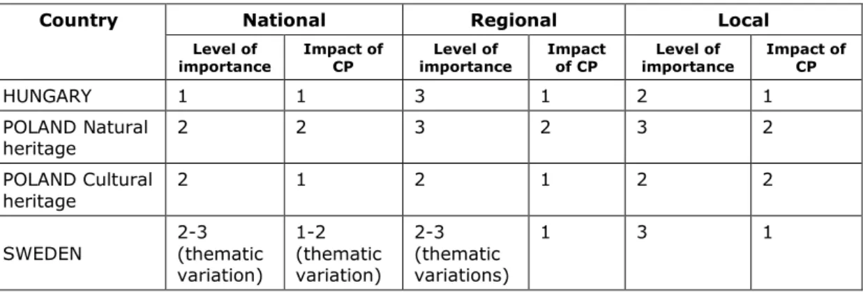
Table 7.1. The assessed importance of issues of natural and cultural heritage, along with the impact of Cohesion Policy ... 23
Table 8.1. Cross-fertilisation: Good practices identified in case studies regions ... 26
Volume 6: Case studies report
Abbreviations
CEEC Central and Eastern European Countries CEF CP Connecting Europe Facility
Cohesion Policy EC European Commission
ESDP European Spatial Development Perspective EGTC European Grouping of Territorial Cooperation ERDF
ESPON European Regional Development Fund European Territorial Observatory Network ETC EU
GATS
European Territorial Cooperation European Union
General Agreement on Trade in Services IPA Instrument for Pre-Accession
MEP Member of the European Parliament
NUTS Nomenclature of Territorial Units for Statistics PHARE
TA2020
Poland and Hungary: Assistance for Restructuring their Economies programme
Territorial Agenda 2020
ROP Regional Operative Programme
TG Territorial Governance
1
1 Introduction
One of the three aims of the COMPASS project is to study in detail how EU Cohesion Policy (CP) and national systems of spatial planning and territorial governance interact and to identify good examples of sound interaction on the ground. The focus is very much on the praxis of these national systems, and the mutual relationship with a key area of European territorial governance: Cohesion Policy. The main objectives of the case studies were:
• to investigate and analyse the relationship between CP and spatial planning systems and territorial governance in practice;
• to identify good practices in case study areas for cross-fertilisation of spatial and territorial development policies with CP.
The case study regions were chosen according to a careful selection procedure. The selection was not restricted to countries where CP plays a key role, but also included some where its importance is relatively lower. The case studies include a variety of spatial planning models. The analyses focused on two areas:
1. the practice of spatial planning systems and territorial governance as a foundation for an efficient and effective absorption of resources;
2. the influence of Cohesion Policy on planning systems and territorial governance.
In a first phase, 13 countries or cross-border regions were selected. An important criterion was the regions’ implementation of Cohesion Policy objectives. In the second phase, a more detailed selection of regions was made. The main selection criteria were:
• the range of policy-making cultures;
• key governance characteristics using the typology proposed in the ESPON TANGO study;
• the regions’ challenges in relation to the TA 2020 thematic issues (see Table 1.1); and
• their exposure to different objectives of the EU Cohesion Policy: convergence; regional competitiveness and employment; and European territorial cooperation.
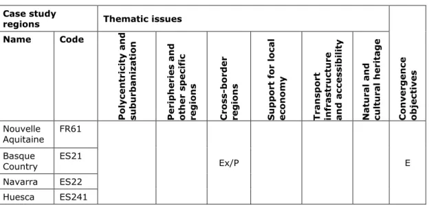
The case studies are located in four countries and one cross-border area (Table 1.3).
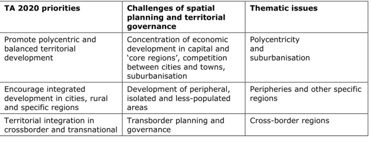
Table 1.1. Relationships between TA2020 priorities and challenges of spatial planning and territorial governance
TA 2020 priorities Challenges of spatial planning and territorial governance
Thematic issues
Promote polycentric and balanced territorial development
Concentration of economic development in capital and
‘core regions’, competition between cities and towns, suburbanisation
Polycentricity and suburbanisation
Encourage integrated development in cities, rural and specific regions
Development of peripheral, isolated and less-populated areas
Peripheries and other specific regions
Territorial integration in
crossborder and transnational Transborder planning and
governance Cross-border regions
2
functional regions Ensure global
competitiveness of regions based on strong local economies
Support for specific local assets (including renewable energy sources and tourism potential)
Support for the local economy
Improve territorial
connectivity for individuals, communities and enterprises
Relations between spatial and transport policy, spatial planning alongside transport corridors
Transport infrastructure and accessibility
Manage and connect regions’
valuable ecological, landscape and cultural features
Planning in areas enjoying protection of the natural environment
Natural and cultural heritage
The information collected in each of the case studies included:
• a national profile and an overview of the selected thematic issues (across the country, or in a limited territory depending on the exact limitation of the case study area);
• two to six examples in different thematic issues (at least one for each of the selected issues) which are the most relevant in terms of the connection between Cohesion Policy and territorial governance/spatial planning;
• ‘good practice’ in cross-fertilising Cohesion Policy with spatial planning/territorial governance, including the level of support from the EU cohesion fund; and the potential to transfer practice to another country.
Three main methods were used to collect information about the case studies:
1. desk research: review of policy documents connecting Cohesion Policy and sectoral policies closely related with spatial planning; and in-depth description of policy, project or programme according to a standardised format;
2. semi-structured interviews with key-players, such as policy-makers, representatives of national authorities, non-governmental actors and practitioners;
3. a focus group workshop in each region based upon a guidance note regarding the content of the topics to be covered as well as the desired composition of the focus group.
The case-study surveys were performed in September 2017. Reports from the case studies were prepared for each country, with a supplied template. Difficulties arose with the assembling of participants for the workshops, so in some cases the focus-group questions were integrated into the semi-structured interviews. Table 1.2 presents the number of interviewees and participants of focus group workshops.
Table 1.2. Numbers of interviewees and participants of focus group workshops Countries/
cross-border case studies Number of interviewees Number of participants of focus group workshops
Pyrenees (Spain/France) 9 -
Sweden 9 -
Poland 6 47
Hungary 8 4
Ireland 9 -
Total: 41 51
Table 1.3. Matrix for the final selection of case studies Countries/
cross- border case studies
Geographic al dimension
Typology of territorial governan ce
Regions for case
studies Thematic issues Converge
nce objective Name Code Polycentricit s
y and sub- urbanisation
Peripheries and other specific regions
Cross-border
regions Support for the local economy
Transport infrastructur e and accessibility
Natural and cultural heritage
Cross- border:
Pyrenees (Spain, France)
South/West II/IV Nouvelle Aquitaine Basque Country Navarra Huesca
FR61 ES21 ES22 ES241
Ex/P E
Sweden Scandinavia I Stockholm SE110 Ex Ex Ex R
Östergötland
County SE123 Ex/P Ex Ex/P R, E
Poland Central/East III Mazowieckie PL12 Ex/P Ex C
Podlaskie PL34 Ex/P Ex C, E
Łódzkie PL114 Ex Ex C
Hungary Central/East III Közép-
Magyarország HU10 Ex/P R
Baranya HU23
1 Ex Ex C, E
Győr- Moson-
Sopron HU22
1 Ex/P C, E
Borsod-Abaúj
Zemplén HU31
1 Ex C, E
Ireland West/
Atlantic II Eastern
Midland P Ex P R
Northern and
Western Ex Ex R
Southern Ex R
Thematic issues cover 3 5 2 6 5 3
*Ex – studied examples, P – good practices to study (all cross-border examples and good practices are treated as one) C - Convergence, R - Regional competitiveness and employment, E - European territorial cooperation
To provide for close study of the interaction between CP and spatial planning/territorial governance, the cases selected were regions at NUTS2 or NUTS3 level. Table 1.4 presents the description and main issues of the analysed case-study regions.
Table 1.4. Descriptions of case studies Country /
case study
regions Main characteristics
Spain-France
Nouvelle Aquitaine, Basque Country, Navarra, Huesca
The cross-border regions include densely populated coastal areas, rural mountainous areas with low densities as well as surrounding large cities in the piedmont. The territory faces diverse challenges: remoteness, isolation, low access and lack of basic services and infrastructures; vulnerability to the effects of climate change and natural hazards; high concentration of economic activities in the service sector which is dominated by small enterprises, often unstable and seasonal; large differences in population densities, both between urban and rural areas, as well as between different regions.
Sweden
Stockholm The Stockholm region is quite prosperous in terms of economic activity, including a high employment rate, increasing population, high levels of innovation and a diverse economy. The northern parts experience an economic growth resulting in a strong economic and transport corridor; whereas the southern parts, traditionally more dominated by consisting of a larger share of manufacturing, are vulnerable due to de-industrialisation and out-sourcing. This is strengthening the north-south divide. Planning challenges revolve around facilitating economic growth,
transportation and housing supply along with improving environmental conditions.
Östergötland
County Östergötland is a (semi) peripheral region in eastern Sweden, fourth largest in terms of population size. In terms of economic activity, the region is slightly above the EU28 average (GDP per capita in PPS). The region has a diverse economic structure although dominated by agricultural and forestry. There are two main cores, Norrköping and Linköping and a unique coastline in the east, including an archipelago. Region deals with issues of a more regional scope, such as urban- rural interactions, attracting people and enterprises, developing public
transportation, strengthening the economic cores and developing outer regions based on their local assets.
Poland
Mazowieckie Mazowieckie is the most diversified region in Poland in terms of socio-economic development. It has well developed service, industrial and agriculture sectors; the metropolis of Warsaw is a pole of growth. The settlement system is unbalanced in terms of demographic potential and supply-demand on the labour market, resulting in strong commuting. Divergence increases as a result of the outflow of population to Warsaw metropolis, with the omission of large and medium-sized cities, endangered with severe depopulation.
Podlaskie Podlaskie Voivodeship is situated peripherally in the north-eastern part of Poland.
The region, characterized by the lowest population density in Poland, is bordered by Belarus and Lithuania; the agro-food industry is the main branch of its
economy. The region is unique in terms of natural and cultural heritage which are of European importance scale. The region has experienced a very high emigration rate; rural areas considerably depopulate, as this is selective the demographic structure is becoming unbalanced and further depopulation is expected.
Łódzkie Łódzkie Voivodeship is characterised by a medium level of economic development.
The region is internally diversified and the diversification of the economy is increasing. There are several functional areas in Łódzkie which face different socio- economic problems. The economic potential of the Voivodeship comprises of a high level of industrialization (the highest share of industry in the GVA generation in Poland). Łódzkie is relatively well-served by the road network; a great advantage is its location on the crossroads of two TEN-T corridors. A major shortcoming of the existing road layout is its bad technical condition.
Figure 1.1. Selection of case studies
2 Policentricy and suburbanisation
2.1 Matters arising from the thematic issues
Polycentric development was recognised as one of the major policy aims in all of the case studies analysed (Table 2.1). However, the settlement characteristics varied between regions.
The main problems are as follows:
• Suburbanisation is mostly significant in the larger urban areas (PL, SE, HU). In some cases, municipalities are key players for promoting and implementing the desired development (SE). In other cases, spatial policy’s emphasis on the largest urban centres has deepened spatial polarisation of the country or region (PL, HU)
• National and regional planning documents consider polycentric development as a spatial strategy to tackle spatial disorder and uncontrolled suburbanisation, for which they define regional cores. Planning and strategic documents at local level define strategic cores in the vicinity of transport nodes. Nevertheless, balanced territorial development is difficult to achieve in cases of malfunctioning land control systems. Central eastern European countries usually set out common goals of promoting polycentric and balanced territorial development and preserving compact cities in national or regional level documents.
However, land-use development activities do little to assist the achievement of these objectives. Moreover, powerful investors tend to influence the provisions of land-use plans, while previously released state regulation reduces possibilities to prevent urban sprawl (HU, PL).
• Two trends occur in parallel: the densification of urban areas close to transport nodes and the concentration of population and economic activity in urban space; and processes of suburbanisation (PL, HU, SE). Urban development in peripheral and sparsely populated areas is a concern, not only confined to peripheral regions, as there are also peripheries within regions or agglomerations (hidden suburbanisation).
• Various challenges associated with polycentric development occur in less-urbanised areas. They may have a lack of critical mass in terms of size and population; a dispersed settlement distribution; and poor accessibility (IR, SP-FR, PL). Polycentric and balanced development would require an improved system of transport infrastructure.
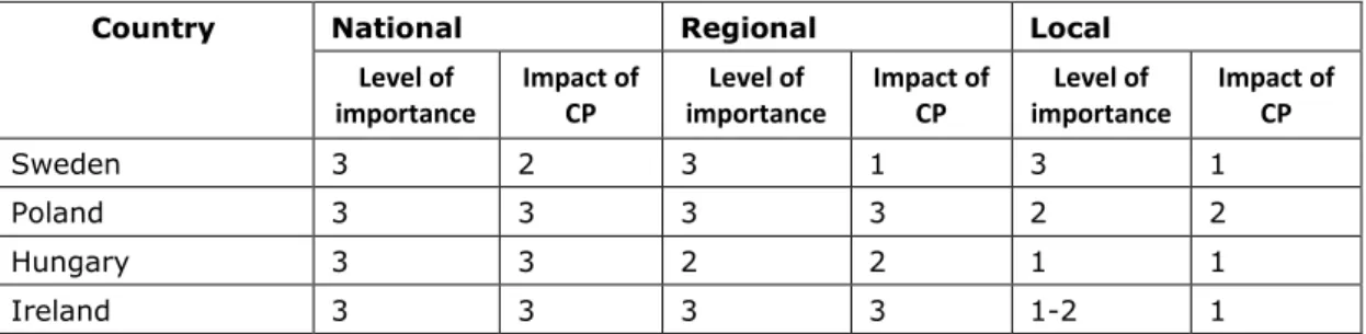
Table 2.1. Level of importance and impact of CP on the thematic issue of Polycentricity and suburbanisation
Thematic
issues National Regional Local
Level of
importance Impact of
CP Level of
importance Impact of
CP Level of
importance Impact of CP
Sweden 3 1 2-3
(regional variations)
2 3 1
Poland 3 1 3 2 2 3
Hungary 3 1 2 1 1 1
2.2 Relationship between Cohesion Policy, spatial planning systems and territorial governance in practice
The degree of CP impact on territorial development was markedly different between countries. In Sweden, the EU policy related to policentricy and suburbanisation issues has
been absent from planning documents, though the EU discourse was present at local and regional level (e.g. with indirect support of the European Security and Defence Policy).
Polycentricity principles were also present prior to the EU accession. On the other hand, while the beneficiaries of CP recognized the influence on the spatial planning system, they did not assessed it positively. New tools were introduced with CP support (supra- communal/regional/territorial development planning documents or agencies) aiming for rational investment and economic efficiency. In practice, however, they mostly served to prepare the programming period, while the development activities of local actors were not coordinated. They could be characterized as a ‘struggle for resources’ resulting in local improvements instead of more balanced regional development.
The aspect more strongly influencing spatial planning systems and territorial governance was dependence on the Structural Funds. In the case of regions with a relatively high GDP per capita (like Budapest and Warsaw), the available EU subsidies for the whole region decreased, producing internal conflicts and a willingness to disconnect from the related agglomeration. This would reduce the capacity to cooperate between local actors, with actual strengthening of urban sprawl processes. What is more, competition between underfunded actors for supplementary resources may weaken cooperation in the public and private sectors. This suggests the need for projects that require common actions from various actors (e.g. good practice: RTI in Siedlce).
A positive impact of CP on more balanced and compact development could be observed in the support of land consolidation programmes (albeit with effects still negligible and hard to assess), infrastructural projects (like a suburban railway and a P&R system), and the development of educational and sporting facilities, as well as the encouragement of increased settlement density in the vicinity of newly-built objects.
On the other hand, the relative ease with which the EU funds may be acquired has resulted in the oversupply of infrastructure investments (e.g. in sewerage and transport infrastructure);
an increase in areas for building development; and excessive dispersion in built-up areas. If such an oversupply of infrastructure occurs beyond the existing urban fabric, dispersion and suburbanisation are stimulated.
2.3 Recommendations
• Spatial planning systems and territorial governance have direct and clear implications when it comes to the promotion of polycentric and balanced territorial development.
However, other policy areas can also prove useful in influencing polycentric development and in managing urban change. Examples might concern the planning of transport infrastructure, or the management of peripheries and other specific regions (via inner-suburbanisation).
• Characteristics of suburbanisation processes vary between beneficiaries of CP. The scale of the phenomenon is unique in Poland, where built-up areas are spreading in a disorderly and dispersed manner. EU policy has not yet contributed to a more balanced
and ‘place-based’ development, since the allocation of EU funds has not been sensitive to inter-country and inter-regional differences. Moreover, the logic applied has been mainly sectoral, albeit with strong decentralisation in metropolitan areas with significant investment pressure.
• A mechanism for bottom-up cooperation and cooperation between neighbouring spatial units is needed. Adoption of the thematic development programmes can be assessed as a good example of the bottom-up approach, recognising the combined interests that generated joint actions. What is more, integrated regional investments have proved efficient tools at local level, strengthening cooperation between actors.
• In countries with malfunctioning spatial policy, implementation of policies and plans needs reinforcement. Clear guidelines (and strict land-use regulations) need to be laid down for the rational allocation of EU funds and the evaluation of real needs (land balance, forecasts, financial implications of urbanisation). Otherwise, CP implementation might produce unintended effects, such as hidden suburbanisation of inner peripheries in the context of revitalisation processes; oversupply of technical infrastructure resulting in excessive allocation of land for development (urban sprawl); and strengthened processes of suburbanisation.
3 Peripheries and other specific regions
3.1 Matters arising from thematic issues
Peripheries and other specific regions, especially at the regional level, represent an issue of moderate/high importance in European countries, whether these are or are not embraced by CP (Table 3.1). Development in peripheral areas is a matter of common concern in the EU, as relates, not only to peripheral regions (from the national point of view), but also to peripheries within regions (even in metropolitan areas like a capital-city region).
Table 3.1. Level of importance and impact of Cohesion Policy on the thematic issue of Peripheries and other specific regions
Thematic
issues National Regional Local
Level of
importance Impact of
CP Level of
importance Impact of CP Level of
importance Impact of CP
Sweden 3 2 3 2 3 1
Poland 3 3 3/2 (depending
on region, and more important in weaker regions)
2 2 1
Hungary 2 2 3 2 2 1
Ireland 1-2 2 2-3
(depending on type of agency involved)
2-3
(depending on type of agency involved)
2-3 2-3
The managing of peripheries interlinks strongly with other thematic issues, as transport infrastructure and accessibility; support for a local economy; and natural and cultural heritage.
It extends to several policy areas and seeks to solve general problems, encouraging integrated development. Problems identified in peripheral areas are as follows:
• Peripheral regions are often the weakest in a given country, suffering from structural problems, and in an unfavourable economic situation, with lacking Foreign Direct Investements (FDI); delayed infrastructural projects; non-innovative industry; and long- term unemployment;
• These regions also face challenges with depopulation (in rural areas); an ageing population; and loss of skilled young people to urban centres;
• The regions are mostly rural, with small and weak economic centres. Their main asset is a high share of areas of high ecological value; representing exceptional local assets in some cases;
• They have a reduced demand for commercial and public key services and an impaired intraregional connectivity; and
These challenges tend to be distributed unevenly across the peripheral regions. Territorial governance issues usually render the situation more complex. Spatial planning needs to find ways to strengthen the region’s competitiveness, using the existing local potential and identifying practices to overcome difficult issues, by way of: a) the activation of local actors to
participate in projects and develop strategic documents; b) the compliance with requirements for the maintenance of areas in a region of high natural value; c) the relatively high overall costs of territorial governance; and d) a proper balance between the reduced demand for public services (schools, childcare and transport) and the delivery of essential services, as the accessibility of the region.
3.2 Relationship between Cohesion Policy, spatial planning systems and territorial governance in practice
In practice, the evaluation of the relationship between CP, spatial planning systems and territorial governance represents a very complicated aspect of analysis, in view of the complexity of the issues related to the development of peripheral areas. However, some differences in spatial planning systems and territorial governance among EU countries may have implications for the management of spatial development in peripheries.
The studied regions place different emphasis on the importance of a spatial perspective for issues of regional development. For example, in Sweden, the non-statutory regional spatial strategy aims to add a spatial layer to the regional development programme through a spatial interpretation; while in Poland, implementation of the Regional operational Programme (ROP) stimulates spatial development through the application of appropriate spatial criteria for evaluating new EU-funded projects.
In peripheral regions a move towards a comprehensive area-based approach has been observed. Integrated development in cities, rural and specific regions needs to be encouraged, not only at regional and municipal level. There are also some central incentives or initiatives promoting horizontal cooperation for the preparation of documents of strategic, operational/interventional or regional-development-related nature. In Hungary, for example, the county concept forms the basis for the Integrated Territorial Programme, relying on strong central coordination and involvement of the county in implementation work. This shares some similarities with the Integrated Territorial Investment (ITI) under the Cohesion Fund,
A further aspect to the relationship between CP and spatial planning is the institutionalisation of communication between local actors, designed to facilitate the preparation of instruments and spatial development in collaboration with municipalities’ programmes of integrated development (community-based planning). However, in some cases local communities do not become involved in topics of local development. For example, in Ireland, though the planning system introduced a non-statutory pre-consultation phase, many communities did not contribute with ideas or visions for spatial planning.
3.3 Recommendation
The results of case studies involving the thematic issue of peripheral areas and other specific regions suggest the following key recommendations:
• In the development of rural areas, problems should be addressed by means of comprehensive programmes, under a place-based approach. Development and implementation of integrated programmes of a comprehensive nature must be based on local capacities characterised by accountability and continuity, with involvement in planning, programming and implementation, and avoiding a constant re-design of the system of regional development.
• General improvements in education and (vocational) training might improve the capacity of local people of becoming aware and involved in local development challenges.
Capacity-building within community groups, NGOs and voluntary groups should be promoted.
• A wider and fuller understanding of the idea that rural policy goes beyond agricultural policy is needed. Shrinking rural areas imply changes in land use which need monitoring.
• Peripheral regions, almost by definition, have a favourable natural environment which needs to maintained and developed in a sustainable way.
• Lagging regions have a strong need of a more systemic approach, especially in terms of territorial governance and CP interactions, avoiding non-coordinated actions and projects leading to dissipation. This can be addressed through formal planning instruments, at both local and regional scale, for example taking advantage of of joint comprehensive plans (horizontal cooperation).
• Horizontal cooperation, but also vertical cooperation (via a top-down approach) has great significance in peripheral areas. Regulatory national interests might be utilised to identify and highlight primary local assets, e.g. environmental protection functions, with EU funding also used to ensure that local specificities act in support of territorial cohesion in a region, as well as structural change.
4 Cross-border regions
4.1 Matters arising from the thematic issues
A significant role of cross-border spatial planning has been revealed in the five case study regions. Specific issues have been identified in the areas adjacent to the external border of the European Union, where problems of cross-border relations coincide with a high level of peripherality. The extent and success of cross-border cooperation, including coordination of spatial planning, are often influenced by natural similarities, the existence or not of common functional areas, as well as historic and cultural factors. On the other hand, the content of cross-border cooperation is widely influenced by regional geographical specificity – e.g.
involving mountain areas and border rivers – as well as settlement aspect – as with borders in the vicinity of metropolitan areas like Vienna and Bratislava – isolated rural settlements – e.g., in mountain areas, for instance in the Pyrenees. Main problems in border areas are described below.
• Cross-border areas are sometimes more exposed to environmental risks and natural hazards, as administrative obstacles may delay response to emergencies or disasters;
• EU structures – Euroregions, INTERREG projects – is very important stimulating cross- border cooperation and establishing its spatial dimension. Without CP support, there may be a breakdown of the cooperation mechanisms that have developed over the years, with reperipheralisation of extensive areas a possible consequence.
• Borderland zones are often areas of of low population density, low industrial activity, but at the same time of high natural value. This is particularly true of mountain areas – such as the Pyrenees – but also areas in which a border has long played a highly formalised role conducive to limited human interference in the natural environment, as e.g. in the Polish-Belarusian borderland. Particular challenges are then laid before spatial planning, which has to simultaneously stimulate development and counter the threats to natural heritage. Even with attempts to integrate planning between two sides, issues associated with environmental protection are not always addressed integrally. An example of this is the Pyrenean Strategy for the valorisation of biodiversity, only in force on the French side of the border;
• Low levels of population density and larger distances to urban cores increase the demand for a fair access to services of general interest. In cross-border areas, spatial planning involves the development and extension of services of general interest, e.g.
joint healthcare emergency services in Serdania, in the Pyrenees. This is of particular importance, especially where the border makes a complicated cut across the local settlement system, e.g. the Spanish enclaves created on French territory in the Pyrenees.
• The role of the institution of cross-border cooperation and its EU support is of particularly great importance in the case of large differences between the spatial planning competencies of the administrative units in neighbouring countries.
• Domestic regulations – e.g. on insurance for people driving machines, or the functioning of public transport – can benefit or hamper the effectiveness of cooperation initiatives undertaken in a spontaneous way (bottom-up) by local units or community groups.
• Many initiatives concern the extension of bilateral linear infrastructures to improve spatial accessibility. At the same time, the quality of transport linkages is largely influenced by
the public transport offer, often fairly poor. In central eastern European countries, this has undergone further deterioration, even in a period during which EU financial resources were available.
4.2 Relationship between Cohesion Policy, spatial planning systems and territorial governance in practice
Regional organisations dealing with cross-border cooperation have an impact on the allocation of resources under the INTERREG project. Cross-border cooperation affects different sectors – culture, environment, tourism, research, mobility, transport, economic development, rural development, emergency services, etc. – but it rarely adopts an integrated approach to cross-border spatial planning. The cooperation remains predominantly sectoral, also within the Schengen zone. Spatial planning fails to perform an integrating role, in the case of external interventions/actions at the cross-border dimension. The priority axes of European Territorial Cooperation (ETC) (INTERREG V) programmes concentrate primarily on crucial sectoral problems – e.g. transport, climate change, and natural hazards – in the clear- cut territorial dimension. Simultaneously, spatial planning does not contribute to the creation of separate axes, as cross-border sectoral coordination is not the goal of CP. Nevertheless, in some cases, joint planning – e.g. for climate change adaptation or protected areas – might be an outcome of a long tradition of joint INTERREG cross-border cooperation.
However, CP in borderland areas is of vital significance, not only where direct financial support is concerned. CP also plays a highly important role in encouraging partners to cooperate, as it is endorsed by the legitimacy associated with EU support. In this way, CP creates essential conditions for future cross-border connections over the long term.
The participation of the authorities at national level in cross-border cooperation may be of positive value, affording better coordination and allowing for co-utilisation of national funds and EU support. But it may also pose certain threats. Neighbouring countries often have differing priorities for cross-border cooperation. Moreover, sectoral regulations at the national level are not always compatible with the local reality, e.g. regulations concerning railways lines of the Intercity type vs. the needs of a local labour market for transport services.
Disparate ownership status of economic entities of a given type – on both sides of a border – are another potential challenge, as CP beneficiaries should be units of local governance, state companies, or private businesses. Example of this is the market for transport services in the borderland between Hungary, Slovakia and Austria.
Other discernibles problem are the legal and administrative discontinuities and the lack of knowledge concerning the competencies of local authorities and other units located on the other side of the border. This hampers access to vital information – e.g. to meteorological data, in the context of adaptation to climate change. Mutual knowledge of the institutional system existing on the other side of the border should constitute the basis for effective cross- border spatial planning.
On the EU’s external border, a closer integration of strictly cross-border activities – supported by ETC programmes – is required, together with internal measures financed with resources stemming from other Operational Programmes. Other programmes – e.g. ROPs in east Poland – frequently offer greater opportunities. Priority axes of these programmes sometimes – mainly alongside the external EU border – do not match with those of INTERREG cross- border programmes in the same region. Inside the EU, more integration can be expected as countries and regions increasingly cooperate in strategies for larger territorial areas, such as macro-regional or sea-basin strategies. This requires both vertical cooperation – at local and regional levels – and horizontal cooperation – between regional authorities, institutions managing the ETC projects, sectoral institutions, foreign units/entities in countries from beyond the EU – what poses exceptionally difficult institutional challenges.
4.3 Recommendations
To enhance joint spatial planning perspectives in cross-border contexts, the following suggestions are made:
• National authorities should establish an ‘intergovernmental commission’ (or equivalent) with appropriate resources to achieve accelerated resolution of certain administrative and operational deadlocks obstructing cross-border activities. Local joint actions involving regulatory planning are much obstructed by administrative mismatches.
• National and regional authorities should use EGTCs and other cross-border entities as knowledge pools and facilitators of soft cooperation. As they are dedicated to cross- border or transnational cooperation, EGTCs can be identified by project holders as legitimate contact organisations. The case studies show that an EGTC can do much to enhance the fast and efficient delivery of cross-border projects.
• Local and regional authorities should support small-scale and grassroots actors willing to cooperate through (1) appropriate project engineering structures, located as close to the need as possible, which can orientate and support ‘would-be’ project holders in their search for financial sources (on the sub-regional scale) and (2) micro-funding for small projects to kick-start cooperation and provide for experimentation / feasibility studies.
• National and European authorities will need to give consideration to changes of area functions in reflection of ongoing spatial processes in a neighbouring country e.g.
suburbanisation spreading beyond state boundaries. Cross-border areas of this type, as in the Vienna-Bratislava-Gyor triangle, may require greater support than it is possible with the funds currently available within the framework of ETC programmes. Better coordination and joint spatial planning is essential.
• For European and regional authorities, CP ought to ensure that support is offered to these instruments and projects as separate priority axes, providing a basis for spatial planning at the cross-border dimension. This includes the creation of joint planning documents, systems of territorial monitoring – as for example in Navarra – and through other entities collecting data covering the spatial aspect, as climate change observatories.
• For European and National authorities, it is expedient to strive for enhanced coordination of activities between ETC projects and other EU Operational Programmes. This is in particular true of measures undertaken in the areas adjacent to the external border of the European Union.
5 Support for the local economy
5.1 Matters arising from the thematic issues
National experts consider support for local economies as an issue of moderate importance in European countries (Table 5.1, Table 7.1). It is a rather general theme that incorporates different policy areas and strongly links with other thematic issues, as peripheral and central areas, and rural and urban areas. Examples of the problems encountered in the studied areas are the following:
• The separation of responsibilities for economic development and spatial planning lead to insufficient coordination between spatial and economic issues. Likewise, the non-spatial approach to regional planning produce strategies without an appropriate reflection of the internal diversification of regions;
• Insufficient coordination and complementarity between different sectoral policies supporting regional and local development;
• Multiplicity of strategies created for overlapping areas with a view to EU funds being obtained, with the potential distortion of the idea of strategic planning;
• Centralisation and top-down approaches of policies important for local development;
• Unintended spatial consequences of intervention in local economies, especially if spatial plans are lacking; and
• Unpreparedness and inefficiency of spatial planning systems for the development of new sectors of the economy, e.g. wind energy.
Table 5.1. Level of importance and impact of Cohesion Policy on the thematic issue of Support for the local economy
Thematic
issue National Regional Local
Level of
importance Impact of
CP Level of
importance Impact of
CP Level of
importance Impact of CP
Sweden 1 1-2 2 2 3 2-3
Poland 2 2 2 3 3 3
Hungary 1 2 2 2 2 2
Ireland 1 1-2 2 2 3 2-3
5.2 Relationship between Cohesion Policy, spatial planning systems and territorial governance in practice
There are large differences between central eastern and western and northern European countries on the support for the local economy. For example, the impact of CP on support for the local economy in Sweden was described by country experts as ‘of little importance’; while in Poland and Hungary its importance is described as strong or moderate.
Member states introduce different planning instruments in support of local economies in areas with specific needs. For example, Hungary established ‘priority regions’ on the basis of the Regional Development and Spatial Planning Act. Spatial plans are adopted by the Parliament and acts and special institutions (councils) are set up with state coordination to develop areas. In the case of the Tokaj sub-region, a national programme was adopted to allocate
funds in support of the local economy. Furthermore, special development concepts and programmes are elaborated for such areas, as a basis for the pursuit of CP and getting European funds.
Polish regions established the so-called Functional Areas, an example of territorial approach to governance. Local authorities and other stakeholders from an area cooperate, identify common socio-economic problems and challenges, and create strategies for development.
Common problems offer a foundation for cooperation for local development, irrespective of administrative borders. There are also other types of areas – like Strategic Intervention Areas – in which territorial instruments are put into effect e.g. Integrated and Regional Territorial Investments. These examples of territorial, functional and network-related approaches to planning and governance inspired by European policies, are relatively new in the central and eastern European countries (CEECs), but increasingly implemented.
There are several examples of regeneration processes in areas with specific needs, as pursued on the basis of European co-funding. A Polish case study involving the city of Łódź offers a positive example of relations between CP, spatial planning and territorial governance.
The possibility of EU funding being raised for revitalisation proved motivating for local authorities in their dealings with local spatial planning. Local spatial plans were adopted after a long time without plans, considered as a major problem in the city centre. A Revitalisation Committee consisting of different stakeholders (NGO, residents, entrepreneurs, etc.) was set up, and a Local Programme of Revitalisation adopted. The result was the successful implementation of several major EU-funded investments.
Positive aspects of the participation of non-governmental stakeholders were also mentioned in an Irish case involving Dublin, and the regeneration of the Ballymun housing estate.
However, Ballymun CP-supported regeneration represents a rather unsuccessful example of planning, as economics risks were not taken into account in the regeneration masterplan.
When the economy crashed, many key infrastructural investments relying on PPP were not pursued. Despite some improvements in housing and physical infrastructure, the socio- economic situation in the area remained poor.
The Swedish case study involving the Stockholm region also offers an interesting example of territorial governance since it involves collaboration between different actors, including local and regional authorities, as well as scientific and business institutions, leading to the preparation of a Innovation Strategy for the region. This project was a positive initiative to build the relationship between economic and spatial planning, in which the spatial planning authority also took part. The examination of the other Swedish case study involving Östergötland led to an emphasis on collaboration between actors to make the region more attractive for the local economy.
The Swedish case studies show other examples of the integration of regional policy and spatial planning. In the Stockholm region, an authority responsible for development issues
and the authority responsible for spatial planning collaborated in the devising of a regional development plan that is both a regional plan for the purposes of the Planning and Building Act and a regional development programme under the so-called Regional Growth Ordinance.
In Östergötland, the regional administration joined 13 municipalities in developing a planning document that adds a spatial layer to the regional development programme, and promotes a functional approach to planning.
5.3 Recommendations
• There is a need to build closer connections between development policy and spatial planning e.g. via the integration of regional policy documents and spatial planning instruments. Spatial planning instruments should be used to coordinate the different policy fields which together define local development. Improved policy integration should be supported, as it remains insufficient across Europe. Spatial policies and plans, even simplified, are necessary to steer local development and prevent unintended consequences of intense economic intervention and development.
• As CP is pursued, more and more emphasis should be placed on the functional diversification of regions. Territorial complexity and complementarity of interventions under different sectoral policies in the functional areas should in particular be promoted, while interventions should be treated as a spatial system.
• CP should promote governance practices based on territorial cooperation and stakeholder networks. Examples of such practices have gained positive assessments from national experts. Processes of ‘citizen and stakeholder engagement in the planning process, generally to facilitate more engagement’ are present in this thematic issue, and are especially important because of its local character.
6 Transport infrastructure and accessibility
6.1 Matters arising from the thematic issues
In most countries, the development of transport infrastructure is dependent on the spatial planning system. This determines the infrastructural configuration of national and regional significance (strategic documents) and regulates the local course of linear investments (local planning). Moreover, in countries that are beneficiaries of CP, a large part of transport investments are pursued with the support of the European Structural Funds. CP overlaps with transport policy, and spatial planning has often proved unprepared for such a significant intensification of investments.
Among the case studies examined, the thematic issue of ‘transport infrastructure and accessibility’ was assessed in Poland central and eastern European countries – in Mazowieckie and Łódzkie Voivodeships–, Ireland – in the Southern Region, Cork –, Sweden – in the Stockholm region – and Hungary – in the Győr-Moson-Sopron county.
The key importance of this thematic issue was emphasised in the studied countries at all geographic levels (Table 6.1), and especially at national level. Dissimilar assessments were observed at local level, with a less-pronounced role attributed to transport and accessibility in Ireland and Hungary. The impact of CP was clearly most significant in Poland and Hungary, and in Ireland at national and regional level. Lesser significance to EU support was only reported in Sweden. In all four countries, the role of CP has been on the decline, while simultaneously moving from the national and regional scale towards the local.
Table 6.1. Impact of Cohesion Policy on the thematic issue of Transport infrastructure and accessibility
Country National Regional Local
Level of
importance Impact of
CP Level of
importance Impact of
CP Level of
importance Impact of CP
Sweden 3 2 3 1 3 1
Poland 3 3 3 3 2 2
Hungary 3 3 2 2 1 1
Ireland 3 3 3 3 1-2 1
Challenges linked to this thematic issue are:
• The impact of CP support for transport infrastructure and accessibility has been uneven in CEECs. The development of the road network has been more coherent and has brought specific improvements of spatial accessibility. But considerably less success has been achieved in the development of the rail network. In some cases, spatial planning procedures were needed for new regulations to refine the implementation of investments in transport. In Poland, most new roads, railways and other facilities have been based on these instruments. Change in legislation has improved the investment process, but simultaneously ‘detached’ infrastructure planning from other forms of land management,
in particular the construction of new housing and commercial centres, which are large traffic generators.
• At local level, instruments for the development of infrastructure have had a poor impact.
In large cities, problems are also generated by outdated local spatial management plans developed before the availability of EU supported investments. They are now an obstacle to changes in communication priorities, such as preferences in public transport, and cycling infrastructure.
• The liquidation of certain planning services in CEECs during the 1990s in order to break with the centrally planned economy, severely constrained the development of transport networks. After 2004, these services had to be re-established.
• In most of the examined countries, the distribution of competences for the construction and maintenance of transport infrastructure is very diverse. The responsibility for the latter is distributed among different actors from the local to the national level, depending on several factors such as ownership of roads, type of infrastructure, etc. The delegation of all these responsibilities and related ones – e.g. spatial objectives – varies even between regions within one country, as in Sweden.
6.2 Relationship between Cohesion Policy, spatial planning systems and territorial governance in practice
The impact of CP on the development of transport networks can be evaluated positively, particularly at the macro-scale. Although funds were gained for the implementation of many projects, the inertia in the implementation of system solutions has remained. CP promotes the development of large transnational projects, while regional and local level networks remain member-state priorities.
The approach towards CP investments in transport infrastructure in the new accession countries was often reactive. It was necessary to create new instruments for spending EU funds. These were endorsed, but they were based on existing funding capability rather than long-term spatial development needs. The special road and railway acts in Poland have accelerated investments, but have at the same time contributed to a reduced significance of the local plan when it comes to the determining of the final courses of new routes. Such a pattern results in conflicts, especially of a social background. Typical NIMBY effects have been observed on a regular basis. Residents' associations question environmental decisions, most often by seeking out minor errors of a formal nature. On the other hand, the most significant positive impact of CP on the process of spatial planning in the new accession countries that experts point to involves the development of both consultation and mediation procedures.
The role of the planning system as a barrier to the efficient implementation of CP transport projects was most evident in urbanised areas, especially those in the vicinity of major cities.
The suburbanisation process has had a direct impact in making the implementation of transport projects more difficult. A significant constraint on the implementation of transport (particularly public transport) projects has concerned difficulties with cooperation between municipalities of a metropolitan area or even between FUAs around medium-sized cities.
Certainly a desired solution enforcing such cooperation has been the Integrated Territorial Investment (ITI) system applied in the current programming period. In Poland, some regional authorities have allocated additional funds for Regional Territorial Investment (RTI), within the Regional Operational Programme operating around the Voivodeship sub-regional centres.
This could be considered good practice (see Chapter 8 on Good practices).
In the case of new developments of more minor scale, including those located more peripherally, project selection often seems to give rise to doubts. For example, funds allocated to the modernisation of regional roads and railways were sometimes over-dispersed (as the result of some kind of egalitarianism whereby each part of a province deserves to receive some investment).
In the countries of EU-15, the issue of transport and accessibility includes the most evident relationship between EU policy and spatial planning and territorial governance, in the way that actors may apply for EU co-funding within the TEN-T programme, or through other EU programmes, rather than by influencing spatial planning systems or territorial governance in general. These programmes and co-funding are useful, and facilitate the implementation of certain infrastructure projects. In this context, the mechanism of the Connecting Europe Facility (CEF) emerged as particularly crucial. On the other hand, EU CP does not really have a bearing on decisionmaking at local level, although its significant role in ‘getting projects off the ground” was acknowledged. In countries with a well-established local (land-use) planning position and tradition, it is not possible to modify transport investments from the European level.
To conclude, it can be assumed that, in the Western European countries, the role of CP in the development of transport and the improvement of spatial accessibility is limited to specific investments within the TEN-T network. At the same time, these investments are implemented as part of local planning systems, which might in some cases suggest a negative impact on the flexibility of solutions at the local scale. In the countries where CP is being implemented its impact is considerable. As the territorial planning and management system is not always prepared for investment on such a large scale, changes are required as the dedicated solutions are introduced. A further problem lies in cooperation between individual entities (including units of local government), which is indispensable in linear investments as well as in the development of public transport. Dispersion of competence in the area of development and the maintenance of transport infrastructure, as well as the functioning of public transport (including in cross-border areas) could be regarded as a pan-European problem.
6.3 Recommendations
The results of the case studies dedicated to the thematic issue of transport infrastructure and accessibility sustain the formulation of the following recommendations:
• Multi-level governance becomes a prime concern in the transport thematic issue.
Horizontal coordination between and within regions is also important, since regional authorities usually have different responsibilities and mandates for the planning and provision of infrastructure. This policy domain is characterised by parallel government arrangements, such as negotiation procedures between the state and local governments, which need to be adapted and related to the formal, and hierarchical, spatial planning system. Transport infrastructure should be seen as a tool for spatial planning and as a sectoral policy, in which spatial planning can be integrated and coordinated with other sectoral policies such as housing.
• Greater integration of transport policy with spatial planning systems is desirable.
Transport policy must take a broader spectrum of territorially-oriented objectives into account. This should not be only to satisfy the increased transport demand of people and goods. In CEECs, the special solutions introduced during the ‘investment boom’
should be gradually integrated with the spatial planning system.
• The introduction of the CEF mechanism should be assessed positively, and its maintenance seems advisable. Concurrently, projects implemented as part of the TEN-T network ought to be assessed from the point of view of their integration with regional and local transport systems. For example, local plans should be assessed in terms of their preparedness for the ‘adoption’ of a large investment.
• Integration of investments at different levels – with special support for co-operating units, further development of IDI and RTI instruments – ought to be a particularly significant criterion when it comes to the selection of future transport projects.
• Access to CP support for major transport projects in metropolises must be flexible. This applies both to the criteria of profitable units (cities with high nominal GDP per capita may not be able to pursue large investments themselves, especially in public transport), as well as rigorous preferences only for specific modes of transport (intermodal solutions are often the only ones that can increase the system's efficiency).
• When transport and accessibility projects are involved, national planning investment agencies should plan the necessary requirements for inter-modal connections in advance of contruction approval. This would reduce delays in the delivery of projects due to planning constraints.