¯¯¯¯¯¯¯¯¯¯¯¯¯¯¯¯¯¯¯¯¯¯¯¯¯¯¯¯¯¯¯¯¯¯¯¯¯¯¯¯¯¯¯¯¯¯¯¯¯¯¯¯¯¯¯¯¯¯¯¯¯¯¯¯¯¯¯¯¯¯¯¯¯¯¯¯¯¯¯¯¯¯¯¯¯¯¯¯¯¯¯¯¯¯¯¯¯¯¯¯¯¯¯¯¯¯¯¯¯¯¯¯¯¯¯¯¯¯¯¯¯¯¯¯
Current Trends of Spatial Planning in Ukraine
Anastasiia Oleshchenko
8Abstract
Current spatial planning system of Ukraine and the types of spatial planning documentation are described in this study. The latest challenges in this field are revealed and discussed, and the newest trends of ensuring data accessibility for public and decision-makers are also outlined.
Keywords: spatial planning, Geographic Information Systems, geoportals, Ukraine
8 State Enterprise ‘DIPROMISTO’, Ukraine; anastasiya@meta.ua
I. Introduction
Spatial planning system in Ukraine goes with its roots back to Soviet period. But during almost 30 years of independence period it has been developed significantly responding to modern demands and geopolitical changes. After 2014, new challenges have been occurred that caused a new wave of system development going on now. Spatial planning in Ukraine is regulated primarily by the Law of Ukraine ‘About basis of urban development’ No. 2780-XII from 16th November 1992, and the Law of Ukraine ‘About the regulation of activity on urban development’ No.
3038-VI from 17th February 2011.
For the second one the amendments
are currently under discussion in the Parliament.
II. Hierarchical Structure of Spatial Planning System in Ukraine
During last several decades a hierarchical structure of a system of spatial planning has been formed in Ukraine. It consists of three basic levels:
national, regional and local, on which the types of spatial planning documentation have been changed few times. Any type of spatial planning documentation consists of graphical (schemes) and text (explanatory notes) materials (Parliament 2011).
¯¯¯¯¯¯¯¯¯¯¯¯¯¯¯¯¯¯¯¯¯¯¯¯¯¯¯¯¯¯¯¯¯¯¯¯¯¯¯¯¯¯¯¯¯¯¯¯¯¯¯¯¯¯¯¯¯¯¯¯¯¯¯¯¯¯¯¯¯¯¯¯¯¯¯¯¯¯¯¯¯¯¯¯¯¯¯¯¯¯¯¯¯¯¯¯¯¯¯¯¯¯¯¯¯¯¯¯¯¯¯¯¯¯¯¯¯¯¯¯¯¯¯¯¯¯¯¯¯
According to the current legislation, the national level is covered by The General Scheme of Planning of the Territory of Ukraine and the schemes of parts of Ukraine.
The General Scheme of Planning of the Territory of Ukraine is the main document defining the strategy of the state development, providing a balance between the interests and needs of different territories. Its first version which is currently in force has been elaborated in the second part of 1990s and adopted by the Law in 2002 (Parliament 2002). The scale of graphical materials is 1:750 000.
The results of the General Scheme implementation are monitored annually and reported to the Cabinet of Ministers of Ukraine (Cabinet of Ministers 2002). The term of the General Scheme realisation is 20 years and currently the work on the new version has to be started.
The new version has to respond both to all the geospatial changes that occurred during passed years within Ukraine and around it and to changes in technological and social demands.
The schemes of parts of Ukraine are covering areas larger than administrative regions having some natural or economic common features such as the Coast of Black Sea and the Sea of Azov,
the Ukrainian Carpathians, cross- border areas etc. For example, there were joint spatial planning projects for cross-border areas with Belarus, Poland, Slovakia and Hungary.
The regional level of spatial planning is represented by schemes of planning of territories of oblasts and raions. The schemes of oblasts are strategic documents of spatial planning and are specifying and developing project decisions of the General Scheme of Ukraine for particular oblast. Such documentation contains principal decisions on a functional zonation of a territory by types of preferential use, planning organisation of a territory, interconnected complex allocation of main objects of industry, transport and engineering infrastructure, protection of settlements from dangerous geological and hydrogeological processes, protection of the environment and cultural heritage, development of the national ecological network. The scale of graphical materials of oblasts’
schemes is 1:100 000. Currently almost all oblasts have such schemes designed during last 10 years with the exception of Cherkaska Oblast, which has been adopted in 2002, Ternopilska Oblast, which is under adoption currently, and Kyivska Oblast, which is under elaboration (DIPROMISTO 2018).
¯¯¯¯¯¯¯¯¯¯¯¯¯¯¯¯¯¯¯¯¯¯¯¯¯¯¯¯¯¯¯¯¯¯¯¯¯¯¯¯¯¯¯¯¯¯¯¯¯¯¯¯¯¯¯¯¯¯¯¯¯¯¯¯¯¯¯¯¯¯¯¯¯¯¯¯¯¯¯¯¯¯¯¯¯¯¯¯¯¯¯¯¯¯¯¯¯¯¯¯¯¯¯¯¯¯¯¯¯¯¯¯¯¯¯¯¯¯¯¯¯¯¯¯¯¯¯¯¯
Downward the schemes of raions are specifying and developing project decisions of schemes of appropriate oblasts. Schemes of raions provide justification of future needs and determination of the predominant directions of the use of territories, taking into account national, public and private interests during planning, development and other use of territories in accordance with the requirements of urban planning, sanitary, environmental, nature conservation, fire and other legislation; justification and definition territories for urban development needs; determination of directions of sustainable development of settlements;
definition of territories with special ecological, recreational, scientific, aesthetic, historical and cultural value; establishment of restrictions stipulated by the legislation on planning, construction and other use of settlements’ territories;
development of city-planning measures for the protection of the environment and the rational use of natural resources, development of measures concerning fire and technological safety. The scale of graphical materials of raions’
schemes varies between 1:10 000 and 1:50 000. Unfortunately, currently only 20 percent of all raions have schemes elaborated after 1991.
The local level is covered by general plans of settlements (master plans), zoning plans and detailed plans of territories.
The general plan of a settlement is the main type of spatial planning documentation at the local level, designed to justify the long-term strategy of planning and building a territory of a settlement. It is developed and approved in the interests of the respective territorial community, taking into account state, public and private interests. The general plan defines the basic principles and directions of the planning organisation and functional purpose of the territory, the formation of a system of public service of the population, organisation of the street and transport network, engineering equipment, engineering preparation and improvement, civil protection of the territory and population from dangerous natural and anthropogenic processes, environmental protection of the natural environment, the protection and preservation of the cultural heritage and the traditional nature of the environment of historical settlements and consistency of implementation solutions, including the development in stages. Depending on the size of a settlement the scale of graphical materials of general plans of
¯¯¯¯¯¯¯¯¯¯¯¯¯¯¯¯¯¯¯¯¯¯¯¯¯¯¯¯¯¯¯¯¯¯¯¯¯¯¯¯¯¯¯¯¯¯¯¯¯¯¯¯¯¯¯¯¯¯¯¯¯¯¯¯¯¯¯¯¯¯¯¯¯¯¯¯¯¯¯¯¯¯¯¯¯¯¯¯¯¯¯¯¯¯¯¯¯¯¯¯¯¯¯¯¯¯¯¯¯¯¯¯¯¯¯¯¯¯¯¯¯¯¯¯¯¯¯¯¯
settlements varies between 1:2 000 and 1:10 000.
On the basis of a general plan of a settlement the zoning plan of the territory is developed with the purpose of determining the conditions and restrictions of the use of the territory for urban development needs within the defined zones. It can be developed within the structure of a general plan or as a separate document.
The scale of graphical materials corresponds with the scale of a general plan. The zoning plan establishes the functional purpose, requirements for the development of separate territories (functional zones) of a settlement, and their landscape organisation.
The lowest type of spatial planning documentation is detailed plan of a territory. Detailed plan of a territory within a settlement specifies the provisions of the general plan of a settlement and determines the planning organisation and development of a territory. A detailed plan of a territory outside settlements is developed in accordance with the scheme of planning a territory (part of territory) of raion and/or oblast, taking into account national and territorial interests. The scale of a detailed plan varies between 1:500 and 1:2 000. A detailed plan of a territory is developed with the
purpose of determining the planning organisation and functional purpose, spatial composition and parameters of the building and landscape organisation of a district, microdistrict, and other part of a territory of a settlement, intended for complex development or reconstruction.
III. Latest Challenges
III.1. Geopolitical rearrangement
Last few years brought significant geopolitical changes for Ukraine that have to be considered in spatial planning documentation.
The most important changes are in external links: thus latitudinal directions got stopped at the eastern side of Ukraine due to political and military conflict with Russia (Figure 1). Also some meridional links had lost their international significance – those going through Kharkiv to the North. At the same time these directions still play important role for Ukraine as internal links.
Partly meridional links kept their international significance – those more western connecting the Baltic Sea with the Black Sea through Poland and Belarus. During last few years the idea of a transport corridor along 25th meridian
¯¯¯¯¯¯¯¯¯¯¯¯¯¯¯¯¯¯¯¯¯¯¯¯¯¯¯¯¯¯¯¯¯¯¯¯¯¯¯¯¯¯¯¯¯¯¯¯¯¯¯¯¯¯¯¯¯¯¯¯¯¯¯¯¯¯¯¯¯¯¯¯¯¯¯¯¯¯¯¯¯¯¯¯¯¯¯¯¯¯¯¯¯¯¯¯¯¯¯¯¯¯¯¯¯¯¯¯¯¯¯¯¯¯¯¯¯¯¯¯¯¯¯¯¯¯¯¯¯
connecting Baltic Countries with Balkans is developed. Such corridor is parallel to Via Carpatia which construction is agreed by EU countries and might go 300 km to the east passing around mountainous areas.
Railway connection also demands significant development within Ukrainian territory due to the differences in railway width.
As changing train from narrow gauge to broad and back takes quite long time and economically is inefficient. Thus the construction of narrow gauge railway along the
western part of Ukraine connecting Poland to Romania is discussed broadly in Ukraine.
Also during last four years significant migration processes took place in Ukraine both internal and external. These migrations still are not absolutely evaluated, but they play essential role in allocation of human and economic resources around the territory of Ukraine (Ministry of Regional Development, Construction and Housing 2017). So obviously has to be considered by spatial documentation of all levels.
Figure 1: Transport corridors through Ukraine
violet – latitudinal links, pink – external meridional links, orange – internal meridional links, violet–yellow – 25th meridian link, red – Via Carpatia, green – railway link Source: edition of the team of DIPROMISTO based on The General Scheme Of
Ukraine implementation monitoring
¯¯¯¯¯¯¯¯¯¯¯¯¯¯¯¯¯¯¯¯¯¯¯¯¯¯¯¯¯¯¯¯¯¯¯¯¯¯¯¯¯¯¯¯¯¯¯¯¯¯¯¯¯¯¯¯¯¯¯¯¯¯¯¯¯¯¯¯¯¯¯¯¯¯¯¯¯¯¯¯¯¯¯¯¯¯¯¯¯¯¯¯¯¯¯¯¯¯¯¯¯¯¯¯¯¯¯¯¯¯¯¯¯¯¯¯¯¯¯¯¯¯¯¯¯¯¯¯¯
III.2. Decentralisation process
One of the key challenges for spatial planning is the process of decentralisation of power, which started in 2014. Nowadays the national policy of Ukraine in the sphere of local self-government is shifted to the interests of citizens of territorial communities (Ukrainian:
‘hromadas’) and stipulates for the decentralisation of power – the transfer of a significant part of powers, resources and responsibilities from the government executive bodies to local self-government authorities.
This policy is based on the provisions of the European Charter of Local Self-Government and the best world standards of public relations in this area.
The process of decentralisation started with the adoption of the Conception of Reform of Local Self-Government and Territorial Organisation of Power in Ukraine in April 2014 (Cabinet of Ministers 2014). The next step should be appropriate amendments into the Constitution of Ukraine, which have been elaborated, but haven’t been approved by the Parliament. And that fact essentially complicated the process of decentralisation, as it has to be done within the acting Constitution.
According to the Constitution in force, the territorial division consists of the Autonomous Republic of Crimea, 24 oblasts, 2 cities with special status (Kyiv and Sevastopol), raions (districts), cities, districts in cities, urban settlements and villages (Parliament 1996). At the same time, the Constitution sets that local self-government is the right of a territorial community – citizens of a village or a voluntary association in a rural community of citizens of several villages, urban settlements and cities – to independently decide local issues within the Constitution and laws of Ukraine. This way since 1996 the Constitution gives the right to amalgamate territorial communities for creation communities capable to exercise local powers.
During last 4 years a range of legislative documents have been elaborated and adopted to ensure financial, regulatory, administrative and organisational decentralisation.
The spatial planning system also couldn’t stay aside of this process. Firstly, spatial planners had elaborated propositions on efficient division of a territory to hromadas (communities) to form indeed capable units. Unfortunately, the voluntary nature of creation of amalgamated territorial communities led to mainly inefficient amalgamation – often too small or too large, some parts of territories are staying between
¯¯¯¯¯¯¯¯¯¯¯¯¯¯¯¯¯¯¯¯¯¯¯¯¯¯¯¯¯¯¯¯¯¯¯¯¯¯¯¯¯¯¯¯¯¯¯¯¯¯¯¯¯¯¯¯¯¯¯¯¯¯¯¯¯¯¯¯¯¯¯¯¯¯¯¯¯¯¯¯¯¯¯¯¯¯¯¯¯¯¯¯¯¯¯¯¯¯¯¯¯¯¯¯¯¯¯¯¯¯¯¯¯¯¯¯¯¯¯¯¯¯¯¯¯¯¯¯¯
amalgamated units and aren’t capable by themselves.
The next step in the field of spatial planning is to respond to the demand of appropriate type of spatial planning documentation for hromadas. Currently the Ukrainian legislation in the field of spatial planning has only one option for this necessity – it is possible to design a scheme of planning of a territory of a part of raion within some territorial entity that can be a hromada. So such works had already started and some hromadas have got such schemes already.
The amendments to the law with the purpose to introduce
appropriate type of spatial planning documentation for hromadas is currently under discussion already in the Parliament. Among the key subjects for discussion is the question whether such type of documentation has to be of regional level detailing (more a strategic document) or of local level detailing (close to the general plan of a settlement). At the same time the amount of types of spatial documentation is also under discussion as it is still not clear enough what role in governance will play raions and settlements with transferring most powers to hromadas.
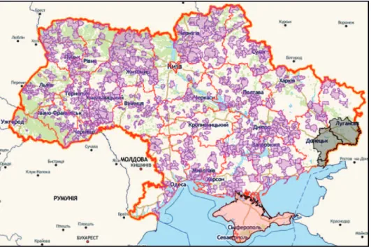
Figure 2: State of creation of amalgamated territorial hromadas in Ukraine Source: Geoportal ATDU 2018
¯¯¯¯¯¯¯¯¯¯¯¯¯¯¯¯¯¯¯¯¯¯¯¯¯¯¯¯¯¯¯¯¯¯¯¯¯¯¯¯¯¯¯¯¯¯¯¯¯¯¯¯¯¯¯¯¯¯¯¯¯¯¯¯¯¯¯¯¯¯¯¯¯¯¯¯¯¯¯¯¯¯¯¯¯¯¯¯¯¯¯¯¯¯¯¯¯¯¯¯¯¯¯¯¯¯¯¯¯¯¯¯¯¯¯¯¯¯¯¯¯¯¯¯¯¯¯¯¯
Only about a half of the territory of Ukraine is currently covered by the officially created amalgamated territorial hromadas (Figure 2). The experts expect activation of this process during the second part of 2018. The processes of spatial planning of hromadas territories aren’t very active due to obscurity of the status of such documentation.
III.3. Public and
technological challenges Spatial planning activity has to respond also to such challenges as continuously raising public curiosity, rapid technological development, demands to data transparency and accessibility, integration of EU approaches and standards. All these challenges are caused by development of civil society and are dictated by general European values.
Valid Ukrainian legislation makes most part of data of spatial documentation open to the public. And the owner of such documentation (usually local or territorial authorities) is responsible for disclosure of necessary materials.
Taking into account the graphical nature and the scale of such materials that is usually not an easy task.
Also the process of spatial planning in itself also has to be
transparent for the public that demands conducting public hearings and meetings. This task sometimes is quite difficult due to underdeveloped culture of public participation and often it turns to confrontation between planners and some narrow group of stakeholders who are protecting their private interests without taking into account the general needs of a community.
At the same time non- governmental organisations are getting stronger and more professional during last few years and discussions with them are shifting more and more to intelligent and reasonable form.
It seems that rapid technological development is not just a challenge but more a mean to respond challenges of public curiosity and demands of data transparency and accessibility.
IV. Geographic
Information Systems as a Respond for the Newest Demands
The key technological background for spatial planning as an activity in geographical dimension are Geographic Information Systems (GIS). Their development went from desktop version to server solutions and finally online cloud technologies
¯¯¯¯¯¯¯¯¯¯¯¯¯¯¯¯¯¯¯¯¯¯¯¯¯¯¯¯¯¯¯¯¯¯¯¯¯¯¯¯¯¯¯¯¯¯¯¯¯¯¯¯¯¯¯¯¯¯¯¯¯¯¯¯¯¯¯¯¯¯¯¯¯¯¯¯¯¯¯¯¯¯¯¯¯¯¯¯¯¯¯¯¯¯¯¯¯¯¯¯¯¯¯¯¯¯¯¯¯¯¯¯¯¯¯¯¯¯¯¯¯¯¯¯¯¯¯¯¯
allowing sharing data collection and management and also ensuring data accessibility from different locations and authorities.
As a desktop application GIS has been used by Ukrainian spatial planners for more than 20 years.
But during the last few years online applications got a rapid development as a response to data transparency and accessibility for the public demand.
Currently the works on creation of Spatial Planning Cadastre on regional and local levels are going on. The aim of such system is to put into the order and make accessible all spatial planning documentation and the results of its monitoring both to decision-makers and public. At the same time having such data kept in GIS-format allows to conduct spatial analysis and modelling for the purposes of daily decision-making and strategic planning.
All this data and instruments for processing it are making available through geoportals – homepages that serve as a gate to geospatial data stored on remote servers.
For today, regional level of Spatial Planning Cadastre is developed better than local due to financial issues and also local spatial planning documentation has much larger amount of data that needs longer time for processing.
At the same time the Spatial Planning Cadastre at national level has to be based on the General Scheme of Planning of the Territory of Ukraine, which is out of date and has to be renewed. That’s why creation of the National Level of Spatial Planning Cadastre intends elaboration of a new version of the General Scheme of Ukraine.
At the same time introducing geoportals technology and creation of a shared but at the same time unified system of such geoportals set demands to input data. First of all, such a system needs spatial planning documentation to be elaborated on unified cartographic basis in national coordinate system (UCS2000). Also to make separate Spatial Planning Cadastre systems integrate with each other demands using of integral classification and coding of features. The work on such classification is currently going on. Also all basic data used for spatial analysis and modelling have to be of reliable accuracy and regularly updated that needs development of clear national data collection and sharing system.
Such geoinformation processes in the field of spatial planning are closely connected to National Spatial Data Infrastructure development – a
¯¯¯¯¯¯¯¯¯¯¯¯¯¯¯¯¯¯¯¯¯¯¯¯¯¯¯¯¯¯¯¯¯¯¯¯¯¯¯¯¯¯¯¯¯¯¯¯¯¯¯¯¯¯¯¯¯¯¯¯¯¯¯¯¯¯¯¯¯¯¯¯¯¯¯¯¯¯¯¯¯¯¯¯¯¯¯¯¯¯¯¯¯¯¯¯¯¯¯¯¯¯¯¯¯¯¯¯¯¯¯¯¯¯¯¯¯¯¯¯¯¯¯¯¯¯¯¯¯
national geoinformation system of shared collection and usage of spatial data of different authorities. That allows more efficient financial support of data collection and maintenance and at the same time ensuring data accuracy by responsible authorities. This concept is developed around the Globe and international experience shows that several decades have to be devoted to elaboration of such system. In Ukraine currently, only the draft law about the National Spatial Data Infrastructure is under discussion, so its creation is a distant future subject. And nowadays creation of sectoral information systems is more realistic.
V. Conclusions
Thus, currently Ukrainian spatial planning system is going through an active process of development due to changes in the administrative division of Ukraine and introduction of latest technologies. Spatial planning system keeps the consistent hierarchical structure of three levels: state, regional and local. But the creation of new administrative division
level of ‘amalgamated territorial hromadas’ (communities) as a basic level of government calls for introducing appropriate level of spatial planning documentation.
These governmental issues are supplemented with modern demands of transparency and accessibility of spatial planning data to any decision-makers and average citizens. The last mentioned demand is supported by active development of Geographic Information Systems and their online capabilities – geoportals. Creation of a joint distributed geoinformation system of spatial planning data is under active discussion and a chain of pilot projects have been implemented already or are now under implementation. This process is closely connected and has to be adjusted with creation of the National Spatial Data Infrastructure, which also takes place currently in Ukraine.
All these trends are demanding significant legislation development considering national traditions, foreign experience and requirements of international agreements. One more noteworthy trend is active participation of public organisations in spatial planning and processes of its development.
¯¯¯¯¯¯¯¯¯¯¯¯¯¯¯¯¯¯¯¯¯¯¯¯¯¯¯¯¯¯¯¯¯¯¯¯¯¯¯¯¯¯¯¯¯¯¯¯¯¯¯¯¯¯¯¯¯¯¯¯¯¯¯¯¯¯¯¯¯¯¯¯¯¯¯¯¯¯¯¯¯¯¯¯¯¯¯¯¯¯¯¯¯¯¯¯¯¯¯¯¯¯¯¯¯¯¯¯¯¯¯¯¯¯¯¯¯¯¯¯¯¯¯¯¯¯¯¯¯
VI. References
Cabinet of Ministers 2002: The Decree of the Cabinet of Ministers of Ukraine ‘On facilitating the implementation of the General Scheme of Planning of the Territory of Ukraine’ No. 1291. from 29. 08.
Cabinet of Ministers 2014: The Conception of Reform of Local Self- Government and Territorial Organization of Power in Ukraine, adopted by the Order of the Cabinet of Ministers of Ukraine No.333-p from 01. 04.
DIPROMISTO 2018: The state of development of planning schemes of Autonomus Republic of Crimea and Oblasts of Ukraine. – http://
dipromisto.gov.ua/files/PlanningSchemesOblasts.pdf – 2018. 06. 29.
Geoportal ATDU 2018: Geoportal of Administrative Territorial Division of Ukraine. – http://atu.minregion.gov.ua/ua/karta – 2018. 06. 29.
Ministry of Regional Development, Construction and Housing 2017: Report to the Cabinet of Ministers of Ukraine about the state of implementation of the General Scheme of Planning of the Territory of Ukraine for 2017. – Ministry of Regional Development, Construction and Housing of Ukraine
Parliament 1992: The Law of Ukraine ‘About basis of urban development’
No. 2780-XII from 16. 11.
Parliament 1996: The Constitution of Ukraine, adopted and ratified at the 5th session of the Verkhovna Rada (Parliament) of Ukraine on 28. 06.
Parliament 2002: The Law of Ukraine ‘About the General Scheme of Planning of the Territory of Ukraine’ No.3059-III from 07. 02.
Parliament 2011: The Law of Ukraine ‘About the regulation of activity on urban development’ No.3038-VI from 17. 02.