POTENTIAL CARBON SEQUESTRATION ACROSS SZENTENDRE ISLAND Lyndré NEL, Malihe MASOUDI
Szent István University, Institute of Natural Resources Protection 2100 Gödöllő, Páter K. u. 1. e-mail: Lyndre.Nel@phd.uni-szie.hu
Keywords: soil carbon, land-use change, land-cover change, InVEST, ecosystem service mapping
Summary: Land-use in Hungarian landscapes have generally seen a decrease in agricultural land and increases in uncultivated land cover and forestry. Such types of land-use change have a cumulative impact on the atmospheric carbon that can potentially be sequestered across a landscape. The transformation of natural vegetation into cultivated land-use types and cultivated into uncultivated types alter the operationality of soil carbon storage across a time scale. This study looks at the land-use change and soil carbon storage potential, as an ecosystem service, on the Szentendre Island (59 km2) in the Danube River, Hungary, in 1998 and 2018. Land-use and land-cover (LULC) and topsoil carbon storage in 1998 and 2018 were mapped with the InVEST (Integrated Valuation of Ecosystem Services and Trade-offs) Carbon Storage and Sequestration Model. Current LULC data were matched with carbon pool data as inputs for the Carbon Model. The resulting maps present the potential carbon storage value of land- use types across the Island for 1998 and 2018. Over 20 years, Szentendre Island experienced changes in LULC;
an increase in artificial surfaces, forests, and pastures, and a decrease in arable land, natural vegetation, and wetlands. Based on the land-use data, our results showed that potentially 736.97 Mg of carbon was stored in the topsoil (0–20 cm) of the Szentendre Island in 1998, compared to 737.33 Mg of carbon in 2018. In conclusion, consideration is given to the land-use change trends and the need for environmental impact assessments and programs that increase soil carbon storage for the highest level of potential carbon sequestration on Szentendre Island.
Introduction
Soil carbon storage, a vital ecosystem service, is the result of interactions among ecosystem processes, like photosynthesis, biomass formation, and decomposition. The physical breakdown of carbon-rich organic matter, or carbon-enriched compounds provided by plants in symbiotic relations, provides the function through which carbon is sequestered into the soil from the atmosphere (Ontl and Schulte 2012). Additionally, it increases soil organic matter levels which improves soil structure and reduces soil erosion, resulting in greater plant productivity and decreased environmental degradation (Brady and Weil 2016).
The continued release of CO
2into the atmosphere throughout the Anthropocene has changed the chemical constituency of the earth’s atmosphere and has resulted in global changes to our climate (Lewis and Maslin 2015, IPCC 2007). Long-term carbon sequestration contributes to the global regulation of the carbon cycle, aiding our need for decreasing dangerous levels of gaseous carbon (Lal 2000, Smith 2004).
Soil acts as a large carbon pool (or sink) and is valued as a structure that enables large-scale carbon sequestration (Lal 2004, Centeri et al. 2014). Various land-use management activities, like agricultural practices, affect carbon storage processes (Schlesinger 1986, Jakab et al. 2016).
Effective management (e.g. forming terraces on sloping lands (Slámová et al. 2015)) can lead to increased carbon sequestration whereas ineffective management leads to soil carbon loss (Dignac et al. 2017, Szalai et al. 2016, Barczi és Centeri 1999).
Studies showed that land-use change and management decisions can have multiple impacts on the structures, processes, and functions of ecosystem services of an area (Sanderman et al.
2017, Gutierrez-Arellano and Mulligan 2018, Yang et al. 2018). Specific LULC types are
favoured in the previously mentioned studies in efforts to sequester carbon. Natural vegetation,
such as forests and grasslands, holds a significant amount of carbon stored in the soil (Malhi
2002, Xiaoke et al. 1994).
Land-use in Hungarian landscapes have generally seen a decrease in agricultural land and increases in uncultivated land cover and forestry (Cegielska et al. 2018, Malatinszky 2016). But few studies focus on landscape-scale carbon sequestration potentials. Land-use change has a cumulative impact on the atmospheric carbon that can potentially be sequestered across a landscape. The transformation of natural vegetation into cultivated land-use types and cultivated into uncultivated types alter the operationality of soil carbon storage across a time scale (Lal 2008).
Landscape managers and planners should know the baseline data and monitoring needs of specific ecosystem services, such as carbon sequestration, to promote continued functionality and provisioning of these services (Burkhard and Maes 2017). Avoiding net carbon emissions through better land-use change and management policies, and increased restoration efforts is a feasible and achievable action in managed landscapes (Janssens et al. 2003). It is important to find a trade-off between the conservation of the biodiversity and the economic productivity of permanent grasslands and also to avoid potential conflicts that arise from the changes in the provision of ecosystem services valuable for different stakeholder groups (Kizekova et al. 2017, Kovács et al. 2015). Residents of the Szentendre Island, a Special Area of Conservation (i.e., part of the Natura 2000 network of the European Union, see e.g. Möckel 2017) in the metropolitan area of Budapest, have indicated interest in the development of an eco-Island which would make soil carbon storage data invaluable information to the Island’s managers (Orosz et al. 2015). According to the latest analyses, the climate-vulnerability of the Szentendre Island is low–medium (Buzási and Dajka 2019) or high (Csorba et al. 2018), while the land cover variability between 1990 and 2012 was low (Szilassi 2017).
The purpose of this study was to map the land-use and land-cover (LULC) and potential soil carbon storage (as carbon sequestration) of the Szentendre Island in the Danube River, Hungary, in 1998 and 2018. CORINE LULC data were analysed with GIS software and matched with carbon pool data as inputs for the InVEST (Integrated Valuation of Ecosystem Services and Trade-offs) Carbon Storage and Sequestration Model (Sharp et al. 2018). This biophysical evaluation forms part of a larger study of soil-related ecosystem services, particularly carbon storage and sequestration.
Material and methods Study Area
The Szentendre Island (hereafter Island) study area (59 km
2) is located along a 35 km stretch in the Danube River in Hungary (47°43'14.2"N, 19°06'31.4"E) (Bőhm 2015). It is home to about 10 000 permanent residents split into four settlements (Orosz et al. 2015). Part of the Island falls within the Danube–Ipoly National Park and several Natura 2000 ecological network areas are found on the Island (European Commission 2012, Gergely 2011). Agricultural practices have taken place on Szentendre Island since the 17
thcentury (Gergely 2011). The current homogenous agricultural landscape includes sunflower, corn, alfalfa, potato, orchards, vineyards and cereals as the main crops (Orosz et al. 2015).
Process
Land-use and land-cover (LULC) of the Szentendre Island in 1998 and 2018 was mapped with ArcMap 10.4.1 (ESRI 2017) based on CORINE 1998 (CL50, 1:50 000) Land Cover Data Layer (FÖMI 2016) and CORINE 2018 (CLC2018, 1:100 000) Land Cover Data Layer (Büttner et al.
2017).
LULC classes were mapped by transforming the raster CORINE layers into polygon layers
(shapefiles), where the same GIS road data was added for both maps as separate road maps for
these years could not be found (OpenStreetMap 2019). Both GIS layer maps were transformed
back into raster data (10×10 m cell size). Both the CORINE LULC class raster data were reclassed into simplified classes (patch types) displayed in the maps; natural vegetation, forests, agricultural land, pastures, wetlands, water bodies, roads, and artificial surfaces (Table 1.). As the distribution of water bodies around and across the Island was of small consequence, it was disregarded in this study.
Table 1. Land-use and land-cover (LULC) typesof the Szentendre Island reclassified from CORINE nomenclature (detailed under description) (Bossard et al. 2000, FÖMI 2016)
1. táblázat A földhasználat és felszínborítás típusok a CORINE elnevezése alapján (részletek a szövegben) (Bossard et al. 2000, FÖMI 2016)
Class (patch type) Description
Agricultural land • Arable land consisting of fields larger or smaller than 10 ha in size.
• Orchards, berry fruit, plantations; Areas of fruit/nut orchards (apples, plums, pears, cherries, peaches, apricots, walnut, chestnut, hazel, almond, etc.) and berry fruit (black and red currants, raspberries, gooseberries, etc.).
• Complex cultivation; juxtaposition of small plots of diverse annual crops, pastures and/or permanent crops. Includes alfalfa, barley, hemp, maize, millet, oats, plum, potato, pumpkin, rye, sorghum, soybean, strawberries, sunflower, vegetables, walnut, and wheat.
Artificial surfaces • Commercial and Industrial: Areas of urban centres with public, administrative, commercial, and industrial buildings, roads, parking lots and artificial surfaces (e.g.
cemeteries without vegetation) cover more than 80% of the total surface.
• Residential: Discontinuous built-up areas with family houses with gardens, leisure areas.
Forest Broad-leaved forest in wet and dry conditions, plantations of broad-leaved forests, young stands and clear-cuts, natural regeneration areas, forest nurseries.
Natural vegetation Natural shrub- and grassland, with and without trees and shrubs.
Pastures Natural and fallow farms; significant cover of natural vegetation, abandoned arable land.
Fields larger or smaller than 10 ha size.
Roads Vehicle roads, tracks, residential streets, and carriageways.
Water bodies Rivers and channels with continuous water supply, artificial reservoirs.
Wetlands Fresh-water marshes.
Soil carbon storage of the Szentendre Island, in 1998 and 2018, were mapped using the InVEST (Integrated Valuation of Ecosystem Services and Trade-offs) Carbon Model (Sharp et al. 2018). InVEST Carbon Model aggregates carbon stored amounts from below-ground biomass, soil, and dead organic matter according to land-use maps and classifications. Inputs include LULC maps (raster) of 1998 and 2018 and carbon stock values per LULC class (an excel file). For this study, reclassed LULC raster data were matched with carbon pool data, using the Land Use/Cover Area frame Survey (LUCAS) Topsoil Database (0–20 cm topsoil sampled) (Tóth et al. 2013), as inputs for the Carbon Model (Table 2.). Artificial surfaces, roads and water bodies were excluded from carbon storage mapping in the model.
Results and discussion
The resulting maps present the different arrangements of LULC classes and potential carbon
sequestration values across Szentendre Island for 1998 and 2018.
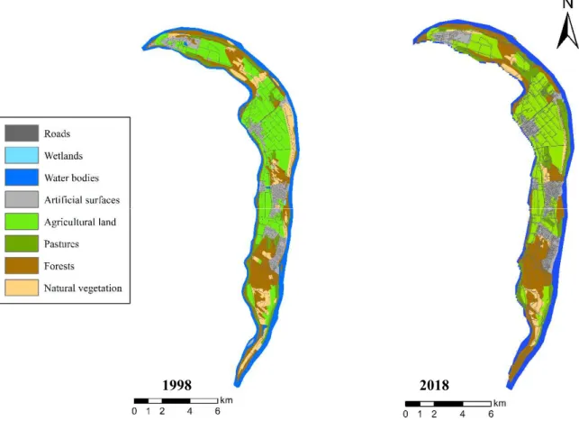
Figure 1. Spatial distribution of land-use and land-cover classes across Szentendre Island in the Danube River, Hungary in 1998 (left) and 2018 (right)
1. ábra A földhasználat és a felszínborítás osztályok területi eloszlása a Szentendrei-szigeten (Duna), 1998-ban (balra) és 2018-ban (jobbra)
The LULC class distribution for the Szentendre Island in 1998 was comprised of agricultural land (22.45 km
2), pastures (4.04 km
2), forests (15.28 km
2), natural vegetation (7.48 km
2), wetlands (0.04 km
2), artificial surfaces (6.37 km
2), and roads (3.5 km
2). Together totaling 59.16 km
2.
The LULC class distribution for the Szentendre Island in 2018 was comprised of agricultural land (21.43 km
2), pastures (7.18 km
2), forests (15.87 km
2), natural vegetation (4.07 km
2), artificial surfaces (7.28 km
2), and roads (3.5 km
2). Together totaling 59.33 km
2.
Table 2. Net % change in LULC classes across Szentendre Island between 1998 and 2018 increase (green) and decrease (red), based on CORINE data
2. táblázat A földhasználat és a felszínborítás osztályok (LULC) nettó %-ának változása (növekedése zöld színnel, illetve csökkenése piros színnel), a Szentendrei-szigeten 1998 és 2018 között a CORINE adatai alapján
LULC Class 1998 % 2018 % Net % Change
Agricultural land 37.95 36.12 -1.82
Artificial surfaces 10.77 12.27 +1.50
Forests 25.82 26.75 +0.93
Natural vegetation 12.64 6.86 -5.78
Pastures 6.84 12.10 +5.26
Roads 5.91 5.91 0
Wetlands 0.07 0.00 -0.07
Net changes in LULC class distributions between 1998 and 2018 (Table 2.) were observed from the maps; there were an increase in artificial surfaces (+1.50%), forests (+0.93%), and
1998 2018
pastures (+5.26%), and a decrease in agricultural land (-1.82%), natural vegetation (-5.78%), and wetlands (-0.07%). The increase in artificial surfaces could be attributed to further residential, commercial, or industrial area development on the Island. The increase in forests and pastures, and decrease in agricultural land, may have been impacted by the additional environmental protection afforded to floodplain gallery forests and adjoining belts by Natura 2000 sites, enforced by 2003 (Gergely 2011).
The difference (0.17 km
2) in the total LULC between 1998 and 2018 is ascribed to the loss of map resolution detail in the GIS map format transformation from raster, to shapefiles, and back to raster for modeling purposes. However, the Island’s surface area may be increasing through the change in the Danube river water level and flows but no evidence has been collected to support this in this study.
Figure 2. Spatial distribution of the potential aggregated carbon density (Mg.m-1) for 1998 (left) and 2018 (right)
2. ábra A potenciális összesített szénsűrűség (Mg.m-1) területi eloszlása 1998-ban (bal oldalon) és 2018-ban (jobb oldalon)
The InVEST Carbon Storage and Sequestration Model calculated that potentially 736.97 Mg of carbon was stored in the topsoil (0–20 cm) of the Szentendre Island in 1998, compared to 737.33 Mg of carbon in 2018 (Figure 3.). The overall potential carbon stock of 2018 is higher than in 1998 and this is due to the increases of forests and pastures, LULC associated with high rates in topsoil carbon storage (Malhi 2002).
Agricultural land and forests make-up a large portion of Szentendre Island (64% in 1998 and 63% in 2018), so these LULC’s contribution to carbon sequestering plays a role in future climate change mitigation and soil conservation. The high soil carbon storage capacity of forests
1998 2018
(Mg.m-1)
is questionable, as in-field observations showed that some forest treelines had substantial anthropogenic impacts where there were roads, water regulation features, dug holes, leftover construction materials, and extremely compacted soil. Data on environmental pressures on the Island are scarce which means that, possibly, various land-uses may not be at full ecological functioning to provide soil carbon storage services.
It is suggested that environmental researchers and professionals carry out environmental impact assessments. LULC change. These assessments assist with the biodiversity monitoring, identification and evaluation of habitat development potentials, habitat capacity, evaluation of landscape multifunctionality, and prospects for landscape planning (Burkhard and Maes 2017), which will significantly contribute to increased soil carbon storage on the Szentendre Island.
Another intervention would include programs that increase soil carbon storage as nature-based solutions (Nesshöver et al. 2017). Strategies for increasing soil carbon pool capacity include soil restoration and regeneration (Boecker et al. 2015), conservation agricultural practices (Lüscher et al. 2016), woodland regeneration, brownfield regeneration (Frantál et al. 2013), mixed cropping, conserving natural areas, and efficient water and nutrient management (Lal 2004).
In-situ soil sampling (of above- and belowground biomass, soil, and dead organic matter) for various LULC classes are needed for the validation of the InVEST Carbon Storage and Sequestration Model results, and to determine the best management practices.
As this study was limited to desktop research, limitations include generalized soil carbon stock for LULC classes based on country-wide soil samples, losing fine-scale detail due to the resolution scale of both 1998 and 2018 CORINE CLC GIS data, no in-field verification of soil carbon stock, and limited data available of land-use management specifics and practices are undertaken on LULC classes which can drastically impact soil carbon storage. Informed decision making in landscape management in this context would need comprehensive in-field validation action and stakeholder engagement.
There is some uncertainty of the CORINE classification of pastures in this context. There is little information from the data to indicate whether this includes meadows, hayfields, or natural grasslands. In Hungary, grasslands are generally used as non-intensively managed as pastures or hayfields and it is not clear how this land-use is categorized within CORINE (Büttner et al.
2017).
This study aimed to determine the soil carbon storage potential on Szentendre Island, as an ecosystem service. After analyses, it was found that the Island potentially contributes to 737 Mg of carbon sequestration with its current LULC distribution. Various land-use changes occurred on the Island between 1998 and 2018 that led to a slight increase in overall potential carbon sequestration. If there would be an increase in LULC transformation from agricultural land and artificial surfaces into forests, natural vegetation and pastures, then the Island could provide increased carbon sequestration services. The map for potential carbon storage in 2018 can be used for location-specific management recommendations and future spatial planning of the Island.
Acknowledgments
Supported by the Stipendium Hungaricum Scholarship (Tempus Public Foundation) and the South African Dept.
of Higher Education and Training.
References
Barczi A., Centeri Cs. 1999: A mezőgazdálkodás, a természetvédelem és a talajok használatának kapcsolatrendszere. ÖKO - Ökológia Környezetgazdálkodás Társadalom 10(1-2): 41–48.
Boecker, D., Centeri, Cs., Welp, G., Möseler, B M. 2015: Parallels of secondary grassland succession and soil regeneration in a chronosequence of central-Hungarian old fields. Folia Geobotanica 50(2): 91–106.
Brady, N.C., Weil, R.R. 2017: The nature and properties of soils. Pearson. 14th edition
Bossard, M., Feranec, J., Otahel, J. 2000: CORINE land cover technical guide – Addendum 2000. Available at:
https://land.copernicus.eu/user-corner/technical-library/tech40add.pdf (Accessed: 30th of January 2020) Buzási, A., Dajka, F. 2019: A Duna–Ipoly Nemzeti Park éghajlati sérülékenységének vizsgálata. Tájökológiai
Lapok (Journal of Landscape Ecology) 17(2): 147–164.
Büttner, G., Kosztra, B., Soukup, T., Sousa, A., Langanke, T. 2017: CLC2018 technical guidelines. European Environment Agency, Wien. 2017. Oct. 25.
Cegielska, K., Noszczyk, T., Kukulska, A., Szylar, M., Hernik, J., Dixon-Gough, R., Jombach, S., Valánszki, I., Kovács, K.F. 2018: Land use and land cover changes in post-socialist countries: Some observations from Hungary and Poland. Land Use Policy 78: 1–8.
Centeri, Cs., Szabó, B., Jakab, G., Kovács, J., Madarász, B., Szabó, J., Tóth, A., Gelencsér, G., Szalai, Z., Vona, M. 2014: State of soil carbon in Hungarian sites: loss, pool and management. In: Margit, A (szerk.) Soil carbon: types, management practices and environmental benefits. New York (NY), USA, Nova Science Publishers pp. 91–117.
Csorba P., Ádám Sz., Bartos-Elekes Zs., Bata T., Bede-Fazekas Á., Czúcz B., Csima P., Csüllög G., Fodor N., Frisnyák S. et al. 2018: Tájak. In: Kocsis K. (ed.): Magyarország Nemzeti Atlasza 2. kötet. Természeti környezet. MTA CSFK Földrajztudományi Intézet, Budapest, pp. 112–129.
Dignac, M.F., Derrien, D., Barré, P., Barot, S., Cécillon, L., Chenu, C., Chevallier, T., Freschet, G.T., Garnier, P., Guenet, B., Hedde, M. 2017: Increasing soil carbon storage: mechanisms, effects of agricultural practices and proxies. A review. Agronomy for sustainable development 37(2): 14.
ESRI (Environmental Systems Research Institute) 2014: ArcGIS Desktop 10.4.1 (GIS Software). Geostatistical Analyst. http://resources.arcgis.com/en/help/main/10.2/index.html.
European Commission 2012: Natura 2000 network. Available from:
https://ec.europa.eu/environment/nature/natura2000/
FÖMI (Hungarian Institute of Surveying and Remote Sensing) 2016. National Land Cover Database (1998/1999) At scale 1:50.000 in Hungary [Vector]. Available from http://fish.fomi.hu/letoltes-/nyilvanos/corine.
Frantál, B., Kunc, J., Nováková, E., Klusáček, P., Martinát, S., Osman, R. 2013: Location matters! Exploring brownfields regeneration in a spatial context (Case study of the South Moravian Region, Czech Republic).
Moravian Geographical Report 21(2), 5–19.
Gergely, A. 2011: Habitat mapping of Natura 2000 sites in Szentendre Island in the Central Region of Hungary–
experiences of the remapping. Problemy Ekologii Krajobrazu 30: 377–380.
Gutierrez-Arellano, C., Mulligan, M. 2018: A review of regulation ecosystem services and disservices from faunal populations and potential impacts of agriculturalisation on their provision, globally. Nature Conservation 30: 1–39.
Bőhm, É. I. 2015: A Szentendrei-sziget tájtörténete. Hungarian-Slovakian cross border cooperation program 2007–
2013 and the European Union. Szigetmonostor, Hungary.
IPCC (Intergovernmental Panel on Climate Change) 2007: The Physical Science Basis. Cambridge, UK:
Cambridge University Press
Jakab, G., Szabó, J., Szalai, Z., Mészáros, E., Madarász, B., Centeri, Cs., Szabó, B., Németh, T., Sipos, P. 2016:
Changes in organic carbon concentration and organic matter compound of erosion-delivered soil aggregates. Environmental Earth Sciences 75(2): 144–154.
Janssens, I.A., Freibauer, A., Ciais, P., Smith, P., Nabuurs, G.J., Folberth, G., Schlamadinger, B., Hutjes, R.W., Ceulemans, R., Schulze, E.D., Valentini, R. 2003: Europe's terrestrial biosphere absorbs 7 to 12% of European anthropogenic CO2 emissions. Science 300(5625): 1538–1542.
Kizekova, M., Feoli, E., Parente, G., Kanianska, R. 2017: Analysis of the effects of mineral fertilization on species diversity and yield of permanent grasslands: revisited data to mediate economic and environmental needs.
Community Ecology 18(3): 295–304.
Kovács, E., Kelemen, E., Kalóczkai, Á., Margóczi, K., Pataki, G., Gébert, J., Málovics, G., Balázs, B., Roboz, Á., Krasznai Kovács, E., Mihók, B. 2015: Understanding the links between ecosystem service trade-offs and conflicts in protected areas. Ecosystem Services. 12: 117–127.
Lal, R. 2004: Soil carbon sequestration impacts on global climate change and food security. Science 304(5677):
1623–1627.
Lal, R. 2008: Carbon sequestration. Philosophical Transactions of the Royal Society B: Biological Sciences 363(1492): 815–830.
Lewis, S.L., Maslin, M.A. 2015: Defining the Anthropocene. Nature 519(7542): 171–180.
Lüscher, G., Ammari, Y., Andriets, A., Angelova, S., Arndorfer, M., Bailey, D., Balázs, K., Bogers, M., Bunce, R. G. H., Choisis, J-P. et al. 2016: Farmland biodiversity and agricultural management on 237 farms in 13 European and two African regions. Ecology 97: 1625–1625.
Malatinszky, Á. 2016: Stakeholder perceptions of climate extremes' effects on management of protected grasslands in a Central European area. Weather, Climate, and Society 8(3): 209–217.
Malhi, Y. 2002: Carbon in the atmosphere and terrestrial biosphere in the 21st century. Philosophical Transactions of the Royal Society of London. Series A: Mathematical, Physical and Engineering Sciences 360(1801):
2925–2945.
Möckel, S. 2017: The European ecological network "Natura 2000" and its derogation procedure to ensure compatibility with competing public interests. Nature Conservation 23: 87–116.
Nesshöver, C., Assmuth, T., Irvine, K.N., Rusch, G.M., Waylen, K.A., Delbaere, B., Haase, D., Jones-Walters, L., Keune, H., Kovacs, E., Krauze, K., Külvik, M., Rey, F., van Dijk, J., Vistad, O.I., Wilkinson, M.E., Wittmer, H., 2016: The science, policy and practice of nature-based solutions: an interdisciplinary perspective. Science of the Total Environment 579: 1215–1227.
Ontl, T.A., Schulte, L.A. 2012: Soil Carbon Storage. Nature Education Knowledge 3(10): 35.
OpenStreetMap Contributors, Geofabrik GmbH. 2019: Open Street Map Data In Layered GIS Format (Hungary Roads). Available from osm-internal.download.geofabrik.de (Accessed: 5th of January 2018)
Orosz, G., Ónodi, G., Sipos, B., Molnár, D., Váradi, I. 2015: Szentendre Eco Island in the Agglomeration of Budapest. Conference Proceedings: Second International Conference on Agriculture in an Urbanizing Society Reconnecting Agriculture and Food Chains to Societal Needs, Rome, Italy, 14th-17th of Sept. 2015.
p. 183.
Sanderman, J., Hengl, T., Fiske, G.J. 2017: Soil carbon debt of 12,000 years of human land use. Proceedings of the National Academy of Sciences 114(36): 9575–9580.
Schlesinger, W.H. 1986: Changes in soil carbon storage and associated properties with disturbance and recovery.
In: Trabalka J.R., Reichle D.E. (eds.): The changing carbon cycle. Springer, New York. pp. 194–220.
Sharp, R., Tallis, H.T., Ricketts, T., Guerry, A.D., Wood, S.A., Chaplin-Kramer, R., Nelson, E., Ennaanay, D., Wolny, S., Olwero, N., et al. 2018: InVEST 3.5.0. User’s Guide. The Natural Capital Project, Stanford University, University of Minnesota, The Nature Conservancy, and World Wildlife Fund
Slámová, M., Jakubec, B., Hreško, J., Beláček, B., Gallay, I. 2015: Modification of the potential production capabilities of agricultural terrace soils due to historical cultivation in the Budina cadastral area, Slovakia.
Moravian Geographical Reports 23(2): 47–55.
Smith, P. 2004: Carbon sequestration in croplands: the potential in Europe and the global context. European Journal of Agronomy 20(3): 229–236.
Szalai, Z.; Szabó, J., Kovács, J., Mészáros, E., Albert, G., Centeri, Cs., Szabó, B., Madarász, B., Zacháry, D., Jakab, G. 2016: Redistribution of soil organic carbon triggered by erosion at field scale under subhumid climate, Hungary. Pedosphere 26(5): 652–665.
Szilassi P. 2017: Magyarországi kistájak felszínborítás változékonysága és felszínborítás mozaikosságuk változása. Tájökológiai Lapok (Journal of Landscape Ecology) 15(2): 131–138.
Tóth, G., Jones, A., Montanarella, L. 2013: LUCAS Topsoil Survey. Methodology, data and results. JRC Technical Reports. Luxembourg. Publications Office of the European Union, EUR26102 – Scientific and Technical Research series.
Xiaoke, W., Yahui, Z., Zongwei, F. 1994: Carbon dioxide release due to change in land use in China mainland.
Journal of Environmental Sciences (China) 6(3): 287–295.
Yang, S., Sheng, D., Adamowski, J., Gong Y., Zhang J., Cao J. 2018: Effect of land use change on soil carbon storage over the last 40 years in the Shi Yang River Basin, China. Land 7(1): 11.
A TALAJ SZÉNMEGKÖTŐ KÉPESSÉGÉNEK VÁLTOZÁSA A SZENDENDREI-SZIGETEN
L. NEL, M. MASOUDI
Szent István Egyetem, Természeti Erőforrások Megőrzése Intézet 2100 Gödöllő, Páter K. u. 1. e-mail: Lyndre.Nel@phd.uni-szie.hu
Kulcsszavak: talaj széntartalma, földhasználati változások, felszínborítás változások, InVEST, ökoszisztéma- szolgáltatás térképezése
A hazai tájak földhasználatával kapcsolatban általában a mezőgazdasági művelés alatt álló területek csökkenése, egyúttal a műveletlen és erdős területek növekedése figyelhető meg. A földhasználat efféle változásai kumulatív hatást gyakorolnak a talaj légköri szénmegkötő képességére. A természetes növényzet megművelt területekké, azaz földhasználati típusokká alakul, ami a művelt területek későbbi felhagyásával idővel változásokat idéz elő a talaj szén-dioxid-tároló képességében. Jelen tanulmány az 59 km2-es Szentendrei-szigeten 1998-ban és 2018-ban vizsgált földhasználat-változást és a talaj szén-dioxid-megkötő potenciálját, mint ökoszisztéma-szolgáltatást állítja középpontjába. 1998-ban és 2018-ban a földhasználat és a felszínborítás (Land-use and land-cover; LULC),
valamint a termőtalaj széntartalma az InVEST (Integrated Valuation of Ecosystem Services and Trade-offs) széntartalom- és szénkivonás-modell segítségével került feltérképezésre. A jelenlegi földhasználati és a felszínborítási adatokat a szénmodell adataihoz illesztettük a szénmodell bemeneti értékeiként. Az így kapott térképek megmutatják a földhasználat-típusok potenciális szénmegkötő képességének értékét a szigeten 1998-ban és 2018-ban. 20 év alatt a Szentendrei-szigeten a földhasználat és felszínborítás jelentős változásokon ment át;
növekedtek a mesterséges felületek, az erdők és a legelők, ugyanakkor csökkent a szántók, a természetes növényzet és a vizes élőhelyek aránya. A földhasználati adatok alapján megállapított eredmények azt mutatják, hogy 1998- ban a Szentendrei-sziget talajának felső (0–20 cm) rétege potenciálisan 736,97 Mg, 2018-ban pedig 737,33 Mg szén raktározására volt képes. Következtetésképpen elmondható, hogy figyelembe kell venni a földhasználat változás tendenciáit, valamint a környezeti hatásvizsgálatok és olyan programok szükségességét, amelyek növelik a talajban megkötött szén mértékét a Szentendrei-szigeten a lehető legnagyobb légköri szénkivonás érdekében.