Land use and landscape management
Harsányi, Endre Juhász, Csaba
Nagy, Attila
Land use and landscape management:
Harsányi, Endre Juhász, Csaba Nagy, Attila
Publication date 2013
Szerzői jog © 2011 Debreceni Egyetem. Agrár- és Gazdálkodástudományok Centruma
Tartalom
... iv
1. 1. Definition, role and significance of land use ... 1
1. ... 1
2. 1.1. Environmental elements important for land use ... 1
3. 1.2. The significance of land use ... 3
2. 2. History and current development of land use ... 5
1. ... 5
2. 2.1. Components of the land use system ... 5
3. 2.2. Classic land use systems ... 6
4. 2.3. Current land use systems ... 6
3. 3. Issues of the elaboration of the integrated land use zone system ... 9
1. ... 9
2. 3.1. The basic model: the land use pyramid ... 9
3. 3.2. The overall combined zone system ... 10
4. 3.3. The concept of realisation ... 12
4. 4. Land use zone system of Hungary ... 14
1. ... 14
2. 4.1. Objectives and fundamental questions of the analyses ... 15
3. 4.2. Database of the analyses ... 15
4. 4.3. Processing of the information ... 17
5. 4.4. Results, conclusion and recommendations of the basic analyses ... 18
5. 5. Land use model scenarios, zonality examples ... 22
1. ... 22
2. 5.1. Change of land use type ... 23
3. 5.2. Designation of Sensitive Natural Areas (SNA) ... 24
6. 6. Relations of farming and land use ... 27
1. ... 27
2. 6.1. Assessment of agricultural land use ... 27
3. 6.2. Land use based on organisational forms ... 29
7. 7. Definition of land, methods of land demarcation ... 31
1. ... 31
8. 8. Productional (agro-ecological) areas of Hungary ... 34
1. ... 34
9. 9. Land use character of agricultural areas ... 43
1. ... 43
10. 10. Assessment of agro-ecological potential in Hungary ... 46
1. ... 46
11. 11. Landscape management ... 50
1. ... 50
2. 11.1. Basic values and content ... 50
3. 11.2. Most important characteristics ... 51
4. 11.3. Basic elements and tools ... 52
4.1. 11.3.1. Diversity preserving farming systems ... 52
4.2. 11.3.2. Technological adaptation to the landscape and the production area ... 53
4.3. 11.3.3. Connection and harmony of plant production and livestock farming ... 58
4.4. 11.3.4. The use of agro-ecosystems which are based on circular processes ... 58
12. 12. Landscape-based production, local varieties ... 63
1. ... 63
2. 12.1. Definition and evolution of locally specific varieties ... 63
3. 12.2. Livestock farming and landscape management ... 64
4. 12.3. Possibilities the preservation of locally specific varieties and their involvement in production ... 65
13. References ... 68
1. ... 68
„Bioenergetikai mérnök MSc szak tananyagfejlesztése” című TÁMOP-4.1.2.A/1-11-/1-2011-0085 sz. projekt
ISBN 978-963-473-699-8; ISBN 978-963-473-700-1 (online)
1. fejezet - 1. Definition, role and significance of land use
1.
The concept of land use is used with a dual meaning. Development and spread of agriculture: The cultivation of arable land and the development of land use types mean classic land use. According to its current meaning land use is the condition related to the overall utilisation and protection of arable land which is in conformity with the record of the users.
From the European history of land use (cultivation) different ownership structures, property redistributions and consolidations of classic civilisation periods and different social era can be revealed. Their knowledge and experience are necessary for the requirements of present social, technical economic developments.
In engineering works and the different regional development activities the experience gained during centuries is essential for the preservation of natural environment and planning, developments based on the knowledge of the past. Methods adapted from earlier development periods are verified by countless examples (ley-farming, the use of transitional grasslands, consolidation methods, etc.) (Jaksch et. al. 1996).
Agricultural land use indicates the use of areas ensuring and supporting agricultural production (cultivation, livestock farming and the infrastructural background). From a different aspect, it shows the location, connection system and environmental relation of land use types (plough-land, garden, forest, etc.). Utilisation of land changes depending on its employment, and the used material and energy outputs. (Tóth 2003).
Soil use is the economic purpose use of soil fertility. Tillage, fertilisation, soil improvement, production, protection and crop rotation are all parts of this concept. Rational use of soil is closely related to its preservation;
in the course of the cultivation processes soil quality (structure, condition, fertility) has to be preserved and improved. Sustainable agricultural production can only be achieved through rational soil utilisation.
Sustainable soil and land use – similarly to the interpretation of sustainable development – have countless definitions. Amongst these, the definition of Tóth (2003) refers to tillage and cultivation in a way, that it observes these activities from the aspect of the preservation of ecological conditions and soil functions.
Sustainable land use is a utilisation type where the use of soil as a resource does not have any irreversible, negative influence to either the soil itself or the other systems of the environment.
Sustainability of agricultural land use is ensured by controllability and impressionability of the material and energy transfer processes related to plant production. Amongst factors that influence land use on a plot level (apart from social and economic factors), ecological parameters, tillage effects and the relation with the neighbouring areas (their potential influence on each other) are the most important. Connection with underground and surface waters and the atmosphere is also important or might become important.
Permanent influence of ecological parameters – for example the meliorative termination of certain unfavourable soil characteristics – and the periodic cultivation, irrigation, nutriment supply and plant protection interventions have difference influence on the nature of material and energy flow processes. When these processes can be controlled, regulated and their necessary feedback is also possible, land use remains sustainable for a long time (Tóth, 2003).
2. 1.1. Environmental elements important for land use
During the 25 century history of Europe the spatial distribution of certain human groups and activities have been determined by three factors. The first environment itself; the second is the attitude and social organisation of the resident people; the third is the technological level of the given community (Dömsödi 2006).
The physical scene of human life is the environment in its entirety. One of its elements is geographic terrain:
mountains, hills, valleys and flatlands. The different geographic conditions have had a different effect on the development of settlement types, transportation, human relations and agriculture. Materials constituting Earth itself are also important elements of the environment. They can be used as construction materials, or they might
1. Definition, role and significance of land use
include water, oil, coal or ores. These materials have been the basis of the development of soil as a result of different climatic conditions and plant covers. Long-term agricultural cultivation also modified – improved or damaged – soil quality. „Soil indicates the quality of the farmer” – and it is a fact that currently the best quality soils are in areas where high-level cultivation has been carried out for centuries. The effect of human activities on soil structure might not be obvious for the first sight, but it is still the most important element of the relationship of people and environment. Finally, climate and weather are also the everywhere present, inevitable elements of the environment. Weather means the everyday change of climatic conditions, while climate is the long-term, average situation. Previously, weather could be forecast only for the next couple of hours, however climate was well-known, and agricultural calendars and the series of feasts which were used for the measurement of time were based on the seasonal changes of the climatic conditions. Climate however does not always conform to the expectations of people. There used to be – even in series – cool, rainy summers and very cold or very moist winters. Such extremes have always caused difficulties. They are somewhat balanced by weather periods that are more favourable than expected, more sunrise than usual and well-timed, proper amount of rain (Dömsödi 2006).
Society itself relates to its environment with settled behavioural patterns. As a matter of fact every community is old-fashioned: once they managed to stabilize their relationship with their environment, they are not willing to bother the balanced situation. They usually accept unusual practices only reluctantly or under pressure, if the lack of food, land or heating material forces them to. People do not carry out any of their activities isolated from the rest; everything they do is part of system and inevitably connects to their other actions; to some extent their every act completes and supports the others. Every innovation, every modification has long-term consequences.
This the clearest in the case of agriculture (the practice of grass-reading, fallowing and three-year cultivation went on even when they become outdated, because all of these methods connected with others in a system that could exist only left intact). Population is not an entirely fixed factor: people might migrate when is search for land or employment. The size and distribution of the population is a significant element of the changing, spatial pattern of human activities. The nature and size of agriculture, the proportions of handcraftmanship or later manufacturing industry always indicate the size of population they have to supply with food, clothing and accommodation. The size of population is not responsible for the development of shortage or prosperity as a sole factor. Population is regulated partly by social morals which might favour juvenile marriage, tolerate child- murder, or raise large families to a special rank. Epidemic or other diseases which are part of the biological environment often had important role in the change of size of certain populations. The significance of the role of diseases have been increased by the development of densely populated areas and migration. On the other hand, technological development resulted in the improvement of cleanness and public health, which reduced mortality (Dömsödi 2006).
The third factor is the element of technological innovation, which is always aimed at the increase or acceleration of production in agriculture or industry. However, behind all these two other factors are constantly there:
political organisation and population. Along some political borders there are often sudden changes which are not justified by the natural habitat. This is explained by the different economic and social policy carried out on the two sides of that border. On the simplest level of the stone age Europe, any area occupied by a culture or a group meant the area of a separated economic system. The same can be said about Greek city-states or Roman cities. Moreover, even in the middle age there was constant aspiration for the rectification of political borders and the increase of their separating role. Power and authority of modern states more extensive than ever, and with the increase of requirements, the significance of political borders increased as well. It seems that along these borders – especially recently –, differences related to the use of arable land, industrial development, transportation and information structures are more and more large. Political borders are almost shattered and they fractured the previously homogenous Europe, which is now more like a mosaic than a unified entity.
People live in settlements the size and shape of these reflects the organisation and economic activity of the given society. Settlement sizes vary from separated farms to metropolises and they are unable to migrate like people or certain industrial sectors; however they can be destroyed or become depopulated. (a series of smaller settlements can have the same population as a large city, but in terms of the method of satisfying the demand of accommodation and subsistence there might be major differences between them). Usually it is thought that cities and villages have qualitative differences. The truth is that a city is on one end of a scale which has a separate farm on its other. Between small towns and large villages there is only a legal difference (many large villages used to be as industrialised as a city, and until the end of the 19th century, thousands of cities used to be as agricultural centred as any village). However, on the very end of the scale, large cities have always been at a great distance from villages: their agricultural functions disappeared, and they became the centre of production and service sectors and governmental/administrative activities. Geographic parameters, climate and soil all play a significant role in where people will cultivate land and they will produce. People have always changed their environment in both social and biological terms. Climate cannot be changed really, but its effect can be
modified at a human scale. Wind protective forest belts, geographically conforming erosion preventing tillage, flooding irrigation and moisture preserving farming are all examples of adaptation to climatic characteristics.
The geographic terrain of an area cannot be changed, but terraces can be made on slopes, and crops can be selected according to the elevation. Soil can be modified to the greatest extent. It is true that poor cultivation might result in the degradation or even the total disappearance of the productive layer of soil, but most of the soils that have been cultivated for a long time have changed as a result of constant ploughing and systematic fertilisation; they are not even similar to the soils that have been started to be cultivated centuries ago at the same place (Dömsödi 2006).
3. 1.2. The significance of land use
Observing the comparative spatial and population data of Hungary it is a fact that our natural resources ensure significantly better conditions for agricultural production than the average of the EU-15, the OECD countries or the world. It can be stated that the plough-land proportion of Hungary is almost the double of the EU-15 average, almost four times larger than the average of the OECD countries, and almost five times more than the world average. If grasslands are included, so the proportion of agricultural areas is observed in terms of the total area, than it is almost the double of the world average (Figure 1).
If specific areas are observed, it can be proved that, in the average of the EU-15 only 234 ha plough- land+garden+plantation is the share 1000 inhabitants, this figure is 255 ha in terms of the world average, 412 ha in the case of the OECD countries and 492 ha/1000 people in Hungary. This means, that beyond supplying its own population, Hungary is capable of producing a significant amount of export goods (Ángyán, 2003).
The above data indicates the production potential of the country, which needs to be utilised by all means, but agriculture does not have to fulfil production-related tasks only. During the development and design of agricultural land use we should not only consider that the rural areas have always been more than production areas, arable land has always been more than a tool of production, and the realised agricultural activities have been more than a productional sector. Having direct relation with 85.5% of the total area agriculture and forestry are the main users of arable land and fundamental tools of preserving and developing rural areas in Hungary.
This also proves that environment- and nature protection are fundamentally dependent on the cooperation with agriculture. On the other hand, performance and yield of agriculture are crucially based on the quality and condition of the environment, natural resources and systems. The dependency of environment and nature protection, agriculture and rural areas make the harmonization of these three areas in terms of land use inevitable (Ángyán, 2003).
1. Definition, role and significance of land use
Multifunctional agriculture which is aimed at the above objective provides social services besides the commodity production activities of environment and landscape management; it produces locally created non- importable public goods, which need to be paid for to the rural population. The sources of these activities might be provided by the transforming agricultural and rural development subsidisation system as part of the CAP reform.
The degree of fulfilment of production and eco-social (environmental and social) tasks within the agriculture of a given area depends on what sort of – lower agricultural potential, environmentally sensitive and hindered by unemployment or high productivity and demographically better – area the given settlement or economy is situated in. While in some areas a family gains income through productive activities, in other areas the eco- social performance of their activities generates state payment and consequently their source of income. This income conceptual income structure distributed by land use categories is shown by Figure 2 (Ángyán, 2003).
For the simultaneous solution of the above tasks, the preservation of agricultural land and the maintenance of the social balance of rural areas industrial agriculture and single-dimension short term effectiveness-oriented farming systems and the related unilateral land use are not suitable. If arable land as a special strategic tool and rural areas as social and biological habitats are intended to be preserved, we need to find solutions which differ from the land use system of industrial agriculture (Ángyán, 2003).
2. fejezet - 2. History and current development of land use
1.
Land use systems have been elaborated as a combined result of the development of the production potential of the society, industrial production and scientific-technological progress. Three periods can be distinguished within the development of the scientific fundamentals of cultivation (Tóth 2006). The first period is characterised by primitive tools, low level of soil utilisation and the generation-by-generation transfer of production experiences. During this period scientific grounding is not yet existent. The second period includes many centuries. Despite of the long period, natural sciences developed a great deal within this era. Agriculture was almost the single production sector and its development was not really aided by the primitive handcraft industry. This period lasted until the end of feudalism. The third period started with the introduction capitalism.
The rapid development of sciences and the results of natural science research had a direct effect on agriculture, but combined with industrial development they had indirect ones as well. The most important basis of the distinction of land use systems is soil utilisation and the upkeep of the activity and the method of its improvement. Soil utilisation is expressed through the relationship of land use types and sowing structure. The method of improving soil productivity can be characterised by the production technology and melioration procedures of the produced crops. (Tóth 2006).
The land use system includes those complex, connected production technology, melioration and organisational procedures which characterise the utilisation of soil, maintenance and improvement of its productivity and quality. With the development of cultivation the methods of soil productivity restoration and improvement have changed as well. In earlier periods restoration was placed under the care of natural processes. In our modern age fertilisation, irrigation, soil improvement, plant protection, new machinery, automatisation, the use of location specific equipment, namely knowingly and scientifically established activities are able to improve the effective productivity of the soil (Tóth 2006).
2. 2.1. Components of the land use system
For the sake of keeping agricultural production on the expected level, such an established cultivation system has to be realised which is capable of making agriculture independent from their varying effects of natural forces.
None of the industrial production sectors require such multilateral consideration of ecological factors like agricultural production. However the size of our country is not large, ecological factors are significantly different in the different parts of the country. This explains why cultivation cannot be developed based on a unified model which is valid for the whole country (Tóth 2006).
There are general components in land use systems which can be found in all of them (Tóth 2006). These are the following:
• the level of agronomical organisation of the farm; the system of soil utilisation and sowing structure,
• the cultivation system,
• the system of plant protection (defense against pests, diseases and weeds),
• system of soil protection.
According to soil, climate and other parameters, additional items might accompany the general components.
Some examples:
• irrigation,
• water management (draining),
• soil improvement,
• forestation (forest belts, groves).
2. History and current development of land use
Land use systems can be distinguished from each other based on the above listed general and additional components. Each component influences the maintenance and improvement of soil quality as well as yield stability. Where annual precipitation is low, irrigation, forestation and cultivation which reduces moisture loss cannot be dispensable. However, in the case of sufficient precipitation and low quality soils, fertilisation has a significant role. On acidic or alkaline soils chemical improvement, while deep, wet soils water management have to be emphasised.
During the evaluation of the role of the listed general and additional components the starting point is the minimum law. This means that the harmful effect of that factor has to be terminated or reduced first, which has limits the effectiveness of the other factors, the maintenance or improvement of soil productivity the most (Tóth 2006).
3. 2.2. Classic land use systems
With the development of society and production tools, land use systems have changed as well. The process of development is classified into more or less periods by different authors. Hungarian literature distinguishes six classic land use systems (Tóth 2006; Ángyán 2003):
• uncultivated, pasture and forest rotation,
• fallow,
• crop rotation,
• grassland,
• free
• monoculture system.
4. 2.3. Current land use systems
As a result of social and economic changes facilitating the development of land use systems and the development of science and technology, the multiple system utilisations of areas became possible. Current land use systems can be distinguished based on their efficiency and their relation with the environment.
The efficiency of a land use system means how much volume and quality is achieved on an area unit based on the involved inputs (material, tools, energy). Efficiency does not necessarily refer to the level of development, because it is modified by economic aspects (the principle of the margin of profitableness).
The relation of the land use system with the environment is characterised by its dependence from natural resources and the extent and nature of their effect on the environment.
Recently developed or currently developing land use systems can be classified as follows according to Kismányoky (2005):
• industrialised production systems,
• alternative (ecological) farming systems,
• integrated cultivation systems.
Industrial, chemicalized farming strategy is characterised by the gradual substitution of natural resources, and their extensive completion with artificial resources as well as the aspiration for yield improvement. With the widening of production, symptoms of natural resource degradation emerge (soil acidification, contamination of living waters, the problem of chemical residue, etc.). Therefore, approaches which subordinate plant production to ecological and environmental aspects start to gain ground. There is a growing interest towards adaptive agriculture and such methods (integrated, alternative, rational, etc.) the effect of which is less harmful to soil and environment than the previous ones. These are complex activities compared to the already covered production systems, because they involve parts or the entirety of agricultural production.
Industrial production systems
In industrial production systems the objective is to achieve high yields by means of the effective utilisation of resources and depending on modern and regulated agro-technological procedures. High biologic value seeds, large amount of fertiliser and pesticides are used for production. Plants are grown based on already developed technological provisions, utilising new scientific results. The exact and effective execution of technological processes is realised by means of modern power engines and machinery. Elements of agro-technology are constantly improved through production experiences and the collection of economic data. The objective is to eliminate the disadvantages of the model-like specified technology, adapting to the changing climatic and economic conditions. (Tóth 2006).
During the early periods, industrial production systems were limited to the more or less complex production of a single plant species (maize, potato, wheat, soy, etc.). However, this unilateral approach did not suit the long- time developed profile of the farms. Although, specialisation has started in plant production as well, most of the systems undertake the modernisation of certain sub-areas only.
In industrial system, production costs are high, the increase of material and energy prices reduce profitability and render production standards uncertain.
The regular – sometimes excessive – use of chemicals is a potential threat in terms of environmental damage (soil acidification, accumulation of chemical residue, pollution of water bases, habitat damage, etc.). Besides, food quality and security might degrade (chemical residue, etc.). Intensive cultivation might result in the degradation of soil condition (dustification, compaction, organic matter insufficiency, etc.). The above listed problems prove the risks of industrial production.
The strengthening of expectations towards the reduction of environmental pressure and the demand for healthier food made the development of new land use trends necessary. In the 1980s, such efforts gain ground within scientific life and practice which supported human and environment centred farming instead of profit oriented industrialised systems that are based on cheap inputs. These approaches manifested as the concept of alternative and integrated plant production (Tóth 2006).
Alternative (ecological) farming systems
According to the definition of Kismányoky (2005) alternative farming systems (organic-biological, ecological, etc.) are aimed at the achievement of ecologically reachable yield levels instead of the maximum exploitation of ecological potential and they urge on compromises in terms of giving up economic advantages.
Giving up higher profits create deficits within farming because of the settling of price levels and state interventions. Production is based on the recycling processes of operative circulation and energy originating from industrial background is used at a decreasing extent. Adapting environmental and landscape management, the use of location specific biological fundamentals and soil type specific, preserving tilling are considered reasonable. The weed control, soil productivity preserving, ecologically balancing role of crops is emphasised in multi-phase crop rotations. Pesticide use is substituted with the agro-technological tools of crop rotation, wide range of varieties, sowing date, tillage, mechanical weed control, etc. Natural materials are used as plant protecting materials. Instead of synthetic N-fertilisers manure or slowly soluble natural forms of phosphor and potassium are used for the maintenance of soil potential. The most important N-source is the inclusion of N- fixing crops into the crop rotation, which results in N03 erosion and the reduction of gaseous losses of ammonia.
Soil productivity is maintained by means of the increasing biomass. The results can be detected in the richness of flora and fauna, biotope protection, the reduction of chemical residues and food quality. As a result of disregarding synthetic pesticides, the danger of crop contamination by toxins produced by pests is increasing.
Therefore alternative and especially economic farming requires proper care and expertise. The spread of ecological farming is determined by the relevant laws. Properly labelled products and regular control are important components of the regulation. (Tóth 2006).
Essential criteria had to be set towards the products:
• Clearly visible labels
• Production has to comply with legal provisions
• Treatment with ionising radiation is prohibited
2. History and current development of land use
• Genetically modified products are prohibited
Risks of ecological farming according to the experiences gained so far:
• In the case of negligence, the crops are ore endangered by diseases then in proper, conventional farming.
• Annual control generates additional costs.
• The introductory phase of ecological farming lays large burdens on the farm, and usually alternative income sources have to be found for the sake of continuous operation.
• Until the natural balance of the ecological system is not yet intact within the farm, fewer crops can be produced and both the soil and the crops are more protected against climatic extremities.
Integrated plant production systems
Integrated farming is aimed at creating, improving and maintaining the harmony of crop demands, production site parameters and economic conditions. It combines (integrates) the advantageous purposes and tools of industrial and alternative systems. Environmental aspects and the new results of scientific-technological development are supported through reasonable compromises. Products are produced with an ecological approach, by using the minimal necessary amount of chemicals and maintaining profitability.
Achieving and maintaining profitability with the least environmental pressure possible is an important task of integrated farming (Tóth 2006).
The integrated approach covers the entire system of land use. Fertilisation is multilateral, the available manure is utilised, further demand is fulfilled with artificial fertilisers. Stubble residues are utilised as the organic matter addition sources of the soil. Green manuring and the integration of green manure crops in the sowing structure have an important role. The system of fertilisation, tillage and crop rotation constitute a harmonious unity with each other, in which humus balance and moisture management are important elements. The value of good soil condition is increased by the chance of reducing climatic extremities.
The task of cultivation within an integrated system (Birkás (2005)) is the establishment, improvement and maintenance of a balance between natural expectations and natural conditions, possibly in an economic way, without environmental damage. The reduction of unfavourable soil characteristics is an indirect objective, just like the improvement of the physical-biological soil condition and green crop effect and the facilitation of the effectiveness of other important interventions (fertilisation, irrigation, plant protection). The advantage and requirement of the tillage laying the foundation of integrated farming is the preservation of the organic matter content of the soil.
In order to reduce environmental pressure, only the inevitably necessary artificial fertiliser and plant protection chemical doses are used. For the reduction of the use chemicals, the producers rely on the results of soil analyses, forecasts, preventive protection, and such procedures of integrated plant protection like the production of resistant varieties, use of crop rotation, etc.
The achievement of an optimal yield level is the objective of integrated systems. The quality and security of the produced crops is good, the amount of chemical residues or biological contaminations (mycotoxins) is minimal or not detectable. Biotope protection can be realised. With the combination of ecological and economic aspects, the concept of sustainable agricultural production can be realised in integrated systems the most (Tóth 2006).
In land use, such a system has to be developed which is the most capable of separating the efficiency of farming from the unfavourable effects of natural forces. Cultivation cannot be developed based on a unified model that is valid for the entire country. Any system or trend is only more innovative as the previous one if it adapts its advantages, carries farming forward, facilitates work, allows the achievement of better quality and can be realised with low costs (Tóth 2006).
3. fejezet - 3. Issues of the elaboration of the integrated land use zone
system
1.
The first, fundamental requirement of a long-term functional, sustainable agriculture is environmental adaptation, which means that land has to be used for a purpose which it is the most suitable for, with an intensity which it is able to bear without damage. (Ángyán, 2000; 2003)
In his work „Stress without distress”, Selye János doctor-biologist writes referring to human societies, that „the lack of stress and too much stress equally cause distress for the majority of people. Therefore everybody should carry out a careful self-assessment in order to find the stress level which makes them feel the best. Those who fail to carry out this assessment suffer from the boredom of idleness or from constant excessive overstrain.”
(Selye, 1976)
It seems that the findings of Selye can be expanded beyond people to the living environment as a whole, nature and its systems as well. Every environment includes the level of utilisation intensity, which does not result in distress, on which it feels the best. Consequently, distress caused by either under-utilisation or overexploitation can be avoided.
Local adaptation, the dependence on local resources is a rational approach not only ecologically or socially, but economically as well. Agricultural activities consist of three main elements:
• environmental conditions, parameters, resources;
• biological objects used for production (plant or animal species/varieties), the related demands
• agro-technical and meliorative interventions aiming at the reduction of the difference os the above two.
Agro-ecological conditions and agro-technological expenditures combined are the inputs of farming, which turn into outputs and products through biological and natural processes. Agro-ecological conditions and their change also appear within these outputs as special products of agriculture. They will be inputs again during the next production cycle (Ángyán 2003).
The production of a given organic matter volume requires a certain amount of energy, which comes partly from the natural resources provided by the agro-ecological conditions, and also originates from technology (agro- technology). So, if ecological conditions are not considered as outputs, and consequently they constantly degrade more and more agro-technological and meliorative energy has to be involved in the system in order to achieve the same yield level. This will have two serious consequences: production becomes less economic and environmental pressure increases. This process strengthens itself, it becomes a vicious cycle which very difficult to escape from (Ángyán 2003).
Environment and landscape management is looking for systems in which the demand and offer side (grown/bred crops/animals and the agro-ecological conditions) are not very different, where the proportion of artificial resources is only supplementary and as little as possible, but natural resources are widely used and their amount does not decrease during the production cycles, but stay at least in balance. If the land use system and intensity does not comply with the potentials of the given area, this error cannot be recovered constantly and effectively by means of agro-technology (Ángyán 2003).
2. 3.1. The basic model: the land use pyramid
The balance of preservation and utilisation is a key issue and starting element of preservative, sustainable farming. In its knowledge, segregation model has to be rejected. The basic principle of the segregation model is the limitation of nature protection to certain surfaces which allows agricultural production without environment oriented responsibility and limitation to be carried out in any other area. However, the other extremity does not
3. Issues of the elaboration of the integrated land use zone system
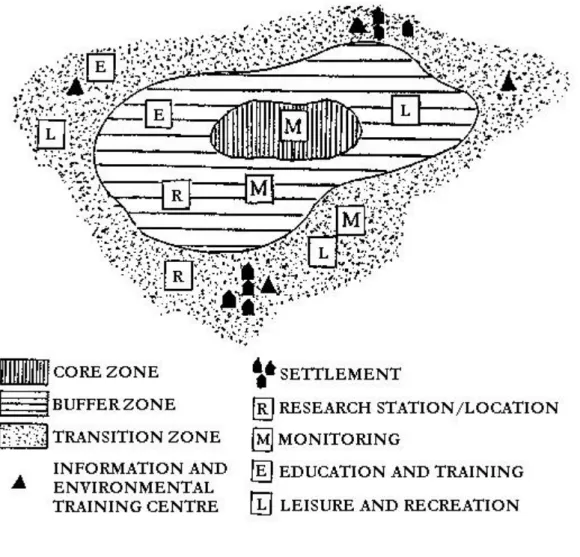
work either, according to which the whole agriculture should be extensified, because then the whole area would became a nature preservation area which would ensure the protection of species on 100% of the area. This approach is untenable, not only because of economic aspects, but it is not entirely true from the aspects of the protection of species finding habitat there, because of the existence of anthropogenic agricultural ecosystems. A third strategy remains, which was first described by Erz (1978) with the so called land use pyramid (Figure 3).
The aim of this strategy, the land use pyramid concept is to integrate land use and nature protection and to determine the intensity of use and protection and their proportion compared to each other. Combining the requirements of nature protection and agriculture, the land use categories of this system are the following (Ángyán 2003):
• On the top of the pyramid there are – regionally different – areas, which have to be nature preservation areas by all means (nature conservation areas, landscape protection areas, national parks, core areas of biosphere reserves), with the total exclusions of other purpose land use;
• below that other protected areas – buffer zones surrounding core areas – can be found with limited, nature preserving agricultural land use;
• then, there are transitional areas requiring certain land use limitations (water reserve areas, buffer zones, etc.), extensive agricultural zones;
• The wide basis of the pyramid is the zone of environment friendly agricultural activities which adapt to the production sites and the size of which depends on what kind of region we are in (high agricultural capacity agricultural areas or high natural preservation capacity, less agricultural area); the intensity of pressure is determined by the nature preservation capacity of the area and the environmental sensitivity of its preserved values.
Industrial agriculture drastically moved the category borders of the land use pyramid upwards; it focused almost exclusively to production aimed functions. Therefore, our inevitable task is to move these borders downwards, reducing the area of intensive land use and to facilitate a proper land use intensity and farming system in every category (Ángyán, 2003; Mőcsényi, 1994).
3. 3.2. The overall combined zone system
This overall zone system of preservation and utilisation functions can be deduced from the two-directional approach, which is shown by the strong environmental orientation of multifunctional agriculture and the concept change of nature protection indicated by the Men and biosphere (MAP) programme. The emergence of the so- called biosphere reserve concept goes back to the beginning of the 1970s, and is based on the fundamental realisation that the preservation ecosystems can only be ensured if instead of isolating protected zones, they
become integrated into their surrounding economic and social environment through gradual transitions (Eigenbrodt-Ott, 1994; Ángyán-Tardy-Vajnáné, 2003).
Biosphere reserves are model areas where besides the protection and tending of certain ecosystems the development of a sustainable land use – together with the residents and their communities – is also an important objective. Since the establishment of the first biosphere reserve (1976) 325 such units have been founded in 83 countries, on 218 million hectares. Its basic functions which can be realised on these areas only in harmony with each other are the following (Ángyán 2003):
1. nature preservation (preservation of landscape, ecosystem, species and genetic diversity);
2. economic integration (facilitation of ecologically and culturally sustainable land use systems and economic development);
3. social integration (carrying out educational, pedagogic, research and monitoring tasks within the areas of local, regional, national and global nature preservation and sustainable development).
The functional extension changed the traditional zone system of protected natural areas as well, and created the so-called transitional zone as a new element. The categories of this zone system are the following:
• core area (Kernzone),
• buffer zone (Pflegezone),
• transition zone (Entwicklungszone).
Figure 4 show the zone system of the biosphere reserve, which also demonstrates the zone distribution of fundamental functions.
3. Issues of the elaboration of the integrated land use zone system
The strengthening economic, social, regional development strategy change of nature preservation since the 1970s, and the environmental and regional opening of the European agricultural policy (especially at the beginning of the 1990s) force the harmonisation of nature preservation, agriculture, and regional development and the elaboration of common land use zone systems. The so-called transition zone has a key role in that, because it links nature protection core areas and their buffer zones with agricultural core areas and creates a dynamic transition between them. This is the zone where a significant agricultural intensity reduction is necessary. This has to be zone based on the dominance of extensive farming methods and traditional land use systems (Ángyán 2003).
4. 3.3. The concept of realisation
The practical realisation of the land use pyramid and the downward move of its category borders the following land use concept is suggested (Ángyán, 1994; 1995/1; 1995/2, 2003).
(1)Withdrawing of areas covered with extreme soils (too dry or too moist areas) from agriculture. Linking them to the existing, valuable biotopes which create a biotope network of durable structures which ensure the protection of plant and animal species living in the wild and endangered biozoeonosises.
The biotope network system, the unharmed habitat system of agricultural landscape, is an essential part of farming; it is its ecological infrastructure, which ensures the preservation of the diversity and ecological character of the landscape, stability of environment and the natural structure of space that it uses areas which have only low agricultural yield potential. Its proportion has to reach 7-12% of the total area even in the case of the best agricultural areas (Ángyán 2003).
(2)In space, which is structured by the biotope network, the withdrawal of limited filtering ability areas from the intensive (industrial) farming, and their transfer to nature protecting (ecological) agricultural land use, combined with the proper remuneration of nature protecting activities.
These are mainly shallow productive layer soils established on a loose basic material; sands and wet production areas which have a limited value in terms of agriculture, but their nature protection value is high. Where these soils cover large surfaces and region – for example landscapes covered by loose structure sandy soils – such a strategy needs to be elaborated to land use, which considers the aspects of agriculture, water management and nature protection as well as the demands of the population towards the landscape (Ángyán 2003).
(3) Integrated, adaptive, nature friendly agriculture in every other area, which has the following requirements:
• production of valuable, chemical residue-free crops by means of the maintenance of soil productivity (termination of soil degradation, support of soil micro-organisms);
• energy-saving use of materials that are only available in a limited amount (phosphate);
• avoidance of the nitrate, plant protection chemical or other pollution pressure of ground water;
• avoidance of the contamination of surface waters (prevention of eroded soil parts, manures, plant protection chemicals to get into water);
• avoidance of air pollution (for example ammonia from livestock farming);
• protection of endangered species and biozoenosises
This concept can be realised by the forestation of grassification of some parts of the intensive cultivated areas according to the land use concept described in section 1, and by their transfer to extensive agricultural course according to section 2 (Ángyán 2003).
With the described land use structure change such a sustainable area use system can be developed, which ensures the harmony of fundamental (nature protection, production and consumption). The basic characteristic of conventional (currently widely used) space use is that production and consumption function spatial structure elements form a network or matrix, in which elements ensuring stability and protection are isolated from each other and they gradually decline. This space use endangers environmental stability even if production and consumption themselves are environment friendly. Only such space use is considered sustainable and balanced, where the islands of production and consumption function spatial structure elements „flow” within the matrix
formed by the protection and stability function naturel biotope network, and where farming and consumption are adapted to their environment and therefore they preserve it (Ángyán, 1991; Ángyán et al., 1995).
In terms of the location of different land use categories in Hungary, those analyses might help which have been the basis of the creation of the Hungarian land use zone system. It is based on the land use (agro-environmental management) value scale which according to the land use pyramid concept has been created with the GIS incorporation and integration of the agricultural suitability and environmental sensitivity/value of areas (Ángyán 2003).
4. fejezet - 4. Land use zone system of Hungary
1.
The most important attributes of Hungarian land covers – the areas of land use types – can be demonstrated based on the CORINE mapping database, with the help of the below table and Figure 5.
It is clear that comparing with both the EU and the world, the proportion of plough-lands is significant in Hungary, whoever the share of forests is below the EU and world average. It is a reasonable question, if it is justified to maintain the current area proportions od land use types or it would be logical to change them, conforming to the basic principles environmental adaptation.
In the course of the basic analyses aimed at the elaboration of the Hungarian land use zone system the experts of the Agro-Environmental Department of the Ministry of Agriculture, the Pedological and Agro-chemical Research Institute of the Hungarian Academy of Sciences, and other institutions cooperated. The conceptioning,
integrating and controlling tasks have been carried out by SZIE-KTI. (Ángyán-Dorgai et al., 1998; Ángyán et al., ed., 1998/1, 1998/2; 1999; Ángyán, 2003; Ángyán-Balázs et al., 2003).
2. 4.1. Objectives and fundamental questions of the analyses
Starting from the land use pyramid concept, the objective of the basic analyses was the elaboration of a land use zone system which
• helps the land use-based establishment of the agricultural issues of the EU accession negotiations;
• indicates the potential target areas of the transforming subsidisation system of the EU;
• can be the basis of the elaboration of a spatially differentiated, but coordinated agricultural, rural, and environmental policy and lays the land use foundations;
• can provide a direct land use basis for the further development of the national long-term regional development concept and the elaboration of the national country planning;
• is able to help the development of a land use structure and farming system which is sustainable, complies with ecological conditions.
The land use zone basic analyses tried to find the answers to the following questions by means of the complex GIS analysis of available land cover databases (Ángyán 2003).
1. What is the situation with the agricultural suitability, agro-ecologic value and environmental sensitivity of Hungary?
2. How can the change of farming intensity of low agricultural potential areas be linked to the area demand of nature protection?
3. How can the areas of the country be categorised by comparing the value scales?
4. Where and how large are the protection priority, agricultural priority, and dual purpose areas? Where can protection, transition and agricultural zones be determined?
5. How does this categorisation affect agricultural and areas and plough-lands?
6. Which agricultural areas and plough-lands can be kept within the intensive agricultural category, where should intensity be decreased, where does the land use type be changed, or where should protective land use be realised?
3. 4.2. Database of the analyses
The parameters of the analysis – amongst the countrywide (available in environmental databases) area parameters – have been the following (Ángyán 2003):
Parameters and databases used for the determination of agricultural suitability
• Geographic and soil parameters
1. Slope categories (Source database: Digital Terrain Database of Hungary, M=1:100000)
2. Hundred point soil value number (Source database: AGROTOPO map, MTA-TAKI, M=1:100000)
3. Average golden crown value of plough-lands (Source database: settlement map of the Ministry of Agriculture and Regional Development)
4. Soil types and sub-types (Source database: AGROTOPO map, MTA-TAKI, M=1:100000) 5. Physical soil types (Source database: AGROTOPO map, MTA-TAKI, M=1:100000)
4. Land use zone system of Hungary
6. Water management parameters of the soil (Source database: AGROTOPO map, MTA-TAKI, M=1:100000)
7. pH and lime condition of the soil (Source database: AGROTOPO map, MTA-TAKI, M=1:100000) 8. Organic matter storage of the soil (Source database: AGROTOPO map, MTA-TAKI, M=1:100000) 9. Thickness of the productive soil layer (Source database: AGROTOPO map, MTA-TAKI, M=1:100000)
• Climatic parameters
1. Energetic agricultural potential (Source database: DATE Debrecen (Szász Gábor) map database) 2. Climatic agricultural potential (Source database: DATE Debrecen (Szász Gábor) map database)
3. Drought potential, drought index (Source database: GATE-KTI synthesis map based on the map database of BME Budapest (Somlyódy László))
4. Maize production climate suitability value number (Source database: GATE KTI (Ángyán József) map database)
5. Winter wheat qualitative climate value number (Source database: GATE NTI (Szabó Miklós) map database)
6. Winter wheat quantitative climate value number (Source database: GATE NTI (Szabó Miklós) map database)
7. Spring barley production climate suitability value number (Source database: GATE NTI (Alapy Balázs) map database)
Parameters and databases used for the determination of environmental sensitivity/value
• Living organisms
1. Nature protection areas of Hungary (Source database: KöM Nature Protection Office, map database, M=1:100000)
2. Planned areas of the National Ecologic Network (NECONET) in Hungary (Source database: KöM Nature Protection Office, map database, M=1:500000)
3. Suggested sensitive natural areas (Souce database: MME (Nagy Szabolcs) map database, M=1:500000) 4. Ramsari areas (Source database: KöM Nature Protection Office, map database, M=1:500000)
5. Bank and shore belts of surface waters (Source database: GATE-KTI map database, M=1:100000)
6. Internationally significant bird habitats (Source database: MME (Nagy Szabolcs) map database, M=1:100000)
7. Important areas for endangered field bird species (Source database: MME Monitoring Centre, map database, M=1:500000)
• Soil
1. Degree of erosion (Source database: MTA-TAKI map database, M=1:100000) 2. Physical soil type (Source database: AGROTOPO map, MTA-TAKI, M=1:100000)
3. Clay mineral quality (Source database: MTA-TAKI (Stefanovits Pál) map database, M=1:100000) 4. pH and lime condition of the soil (Source database: AGROTOPO map, MTA-TAKI, M=1:100000) 5. Organic matter storage of the soil (t/ha) (Source database: AGROTOPO map, MTA-TAKI, M=1:100000)
• Water
1. Underground water preservation areas (Source database: VITUKI map database, M=1:500000) 2. Surface water preservation areas (Source database: VITUKI map database, M=1:500000) Land use, land cover databases
• Land cover database (Source database: Büttner György, 1996, FÖMI CORINE Land Cover database, M=1:100 000; European Commission, 1994) (Figure 5)
• Digital database of the Hungarian forest areas (Source database: Ministry of Agriculture, Forestry Office, map database, M=1:20000)
4. 4.3. Processing of the information
The territorial analysis of the database has been carried out with the following steps in logical order (Ángyán 2003):
• The listed 30 environmental variables have been categorized and every variable and category has been weighted (they have been indicated with a number) based on their role in the elaboration of agricultural fertility and environmental sensitivity/value. For the weighting the results of our earlier analyses, correlation analyses have been used and where they were not available, priority values provided by the experts and institutes who produced the databases have been utilised.
• The territory of the country has been divided into 9.3 million pcs. of 1 hectare cells with a 100x100 m grid, then placing this grid onto the territorial distribution maps of the variables, the values of the environmental parameters have been determined for each hectare of the country. This resulted in 30 environmental values/cells.
• The 16 agricultural suitability and 14 environmental sensitivity value numbers have been summarised by observation units (1 hectare cells), and these have been visualised on maps. Each hectare of the country has been placed on an agricultural suitability and an environmental sensitivity scale between 0 and 100 values.
4. Land use zone system of Hungary
• Environmental sensitivity values have been deducted from agricultural suitability values and 100 has been added to the difference. Like that, a 0-200 value scale has been created, where values below 100 refer to the environmental sensitivity determination of the given area, while values above 100 refer to agricultural determination. To the two edges of the scale the clearly determined areas have been placed (agricultural or environmental), while in the middle of the scale dual determination areas (environmentally limited extensive agricultural areas) are located. These values have been visualized on a synthesis map.
• With the help of this synthetic (agricultural and environmental) three scenarios have been created for the elaboration of the land use zone system where:
• areas with a value under 100 (average) have been put into the protective zone,
• areas with values of 100-120, 100-125 and 100-130 into transitional (protective-agricultural) zone, while
• areas above 120, 125 and 130 have been put into the agriculture zone.
• Distribution of currently agricultural areas and plough-lands amongst these zones has been surveyed, and the land use character of Hungarian landscapes has been analysed.
• Finally, based on the scenarios, suggestions have been made to the changing course of land use types, their internal proportion and territorial placement.
5. 4.4. Results, conclusion and recommendations of the basic analyses
Agricultural suitability of the territory of Hungary
With the GIS-based summary of the 9 soil characterising parameters, the agricultural soil suitability value map has been created, the summary of the 7 complex climate characterising parameters resulted in the agricultural climate suitability map. The combination of the climate and soil suitability value numbers, namely the weighted summary of the 16 parameters resulted in the agricultural (plough-land) production suitability map of Hungary (Figure 7) (Ángyán 2003).
The increase of the value refers to the improvement of agricultural production suitability. Based on the results of the analysis it has been found that measuring on a 0-100 scale, 35% of the total territory of Hungary and 43% of its agricultural territory is excellent agricultural area.
Environmental sensitivity/value of Hungary
Summarizing the 14 parameters used for the estimation of environmental sensitivity/value and which involve living organisms, soil and water bases, the living organism, soil and water basis sensitivity maps of the country have been created, and after combining the 14 parameters, the synthetic environmental sensitivity map og Hungary has been made (Figure 8) (Ángyán 2003).
4. Land use zone system of Hungary
The increase of this vale indicates the growth of sensitivity. Based on the results of the analysis it has been found that measuring on a 0-100 scale, 10% of the total territory of Hungary and nearly 5% of its agricultural territory is situated in explicitly sensitive areas in terms of environmental aspects (Ángyán 2003).
Combination of agricultural suitability and environmental sensitivity value numbers
The distribution of the 9.3 million pieces of 1 hectare area units within the coordinate system of environmental sensitivity and agricultural suitability value scales points towards the important methodological and regional development conclusion, that in the case of the majority of areas, agricultural potential declines with the increase of environmental sensitivity. With the combination of the two aspect systems, most of the areas can be classified into a certain zone that it does not damage agricultural and environmental aspects. In other words, environmental and agricultural interest is not in conflict in most of the areas, the two aspects seem to be well combinable within a joint land use zone system (Ángyán 2003).
With the combination of agricultural suitability and environmental sensitivity values based on the above method, the agro-environmental management base map of Hungary has been created, which places every hectare of the country onto a 0-200 agricultural suitability and environmental sensitivity scale (Figure 9).
Land use character of Hungarian regions
The agro-environmental management value of our regions and their related land use character is significantly different. This characteristic can be well analysed with the comparison of the zonation base map and the Hungarian regional cadastre map.
5. fejezet - 5. Land use model scenarios, zonality examples
1.
With the use of the 0-200 scale zonation base map the limits between protective, extensive agricultural production and intensive agricultural production land use zones can be set at different agro-environmental management numbers. Three scenarios have been created for the indication of the zones (Ángyán 2003), where:
• areas with a value below 100 (average) are in the protective zone,
• areas with a value between 100-120 (1st scenario), 100-125 (2nd scenario) and 100-130 (3rd scenario) are in the transitional (protective-agricultural) zone, while
• areas with a value above 120 (1st scenario), 125 (2nd scenario) or 130 (3rd scenario) are in the agricultural zone.
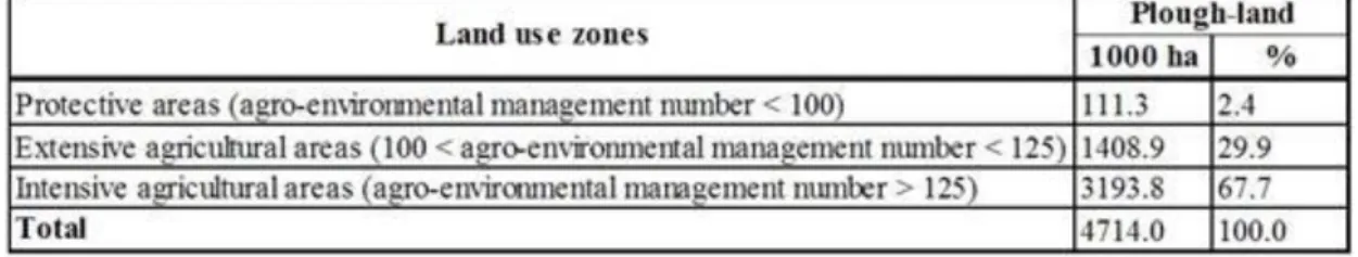
This zone maps can be compared with our current agricultural areas. Carrying out this analysis, and removing the non-agricultural areas from the zones with the help of CORINE land cover database (Figure 5) it can be stated that, depending on the scenario, almost 4% of our agricultural area (approx. 230,000 hectares) are within the protective zone, 26-46 % (approx. 1.6-2.8 million hectares) are within the extensive agricultural zone, and 50-70 % (approx. 3.1-4.3 million hectares) are within the intensive agricultural zone. In terms of the total area of the country, the above values respectively: 10-11 % (0.9-1.0 million hectares), 32-50 % (3.0-4.6 million hectares) and 40-58% (3.7-5.4 million hectares) (Table 2).
Analysing, how our current 4.7 million ha of plough-land is distributed amongst the three zones, it is found that according to the 2nd scenario, one/third of our plough-lands are situated in sensitive, weak or very weak productivity areas which are only slightly suitable for agricultural production (Figure 8), therefore the maintenance of the plough-land land use type is not justifiable either environmentally or economically.
Table 3 summarizes their distribution according to the 2nd scenario.
2. 5.1. Change of land use type
Comparing the information of the map summarising the analyses of land use zones (Figure 9) with the information of Figure 5 (CORINE), the current land use, for example the actual areas of the 4.7 million hectares of plough-land land use type (Figure 10), it can be stated that, on almost one/third of the plough-lands (yellow and green areas) a significant land use type change and a farming system and intensity change are necessary.
These dual purpose (yellow) or protective (green) plough-lands are slightly or not at all suitable for field cultivation; they have been created during the industrialisation of agriculture, and the period of intensive cereal production, usually as a result of deforestation or on former grasslands. On these areas the maintenance of the plough-land land use type is not justified either environmentally, or economically (Table 4) (Ángyán 2003).
5. Land use model scenarios, zonality examples
Based on the result of this analysis, 1.5 million hectares should be withdrawn from intensive farming, from which starting from the lowest productivity and environmentally most sensitive areas to the higher yield potential and less sensitive areas approximately:
• 6-700,000 hectares should be forested,
• 3-400,000 hectares should be grassified,
• 500,000 hectares could be transferred into extensive farming,
• 20-20,000 hectares could be transferred into gardens, orchards, vineyards, reeds and ponds.
As a result of the above, the proportion of land use types could change according to Table 5.
3. 5.2. Designation of Sensitive Natural Areas (SNA)
Environmental sensitivity maps (soil, water, living organisms and complex) – produced during the elaboration of the land use zone system – provide significant help for the designation of target areas of the SNA system.
Based on those, such areas are considered potential SNA target areas that are sensitive above the average f the 9.3 million hectares according to the maps.
These above-average sensitivity areas can be determined from the aspects of all three environmental elements, and with the GIS-based combination of these the synthesis map of potential SNA areas can be created (Figure 11) (Ángyán 2003).
Based on that, the different areas of the country can be categorised by their sensitivity in terms of environmental aspects. According to this category system, certain areas less sensitive than the country average in all aspects.
There are areas which are sensitive according to 1-1 environmental elements (soil, water, living organisms), some are sensitive in terms of 2-2 aspects and some are sensitive in all three aspects. The statistical data of these areas is summarised by Table 6 (Ángyán 2003).
Using this map and table and assessing the potentially sensitive natural areas based on the importance natural protection support the size of the determined area involved by SNAs is 3.3 million hectares which is 35% of the total territory of the country. Their statistical data based on their order of importance is shown by Table 7.
5. Land use model scenarios, zonality examples
The programme started in 2002 on 11 SNA sample areas. Additional territorial programmes might be launched annually according to the priority order (Ángyán-Podmaniczky-Vajnáné, szerk., 2002; 2003; Ángyán-Tardy- Vajnáné, szerk., 2003).
6. fejezet - 6. Relations of farming and land use
1.
The most important natural resource of Hungary is arable land. Quality of plough-lands, soil types, physical parameters, geographic and climatic conditions are advantageous for agricultural production. Factors which influence land quality result in significant differences within the territory of Hungary. Smaller territorial units can be characterised with specific production site attributes, which allows the production of locally specialised, unique crops (Harsányi 2004).
2. 6.1. Assessment of agricultural land use
Agriculturally utilised areas faced a multilateral change during the last century in Hungary. It is a general tendency that due to the establishment of infrastructural facilities – especially during certain periods of the 20th century – the size of agriculturally utilised areas significantly decreased. In 2002, 83.1% (7,732,000 hectares) of the total area of the country (9,303,000 hectares), used to be arable areas. During the last 50 years, cultivated land decreased by 9.8% compared to 1950, while the proportion of areas withdrawn from cultivation increased by 215.8%. Currently, 75.9% of the cultivated land (5,867,300 hectares) is under agricultural cultivation.
4,515,500 hectares are plough-land, this is almost the half (48.54%) of the total area of the country. Almost 50%
of this has excellent agricultural potential, its suitability for agricultural production is above average, however approximately 10% of it is located in environmentally sensitive areas. The current production level is extensive farming, which – considering the Hungarian Agricultural potential – is far from being advantageous (Harsányi 2004).
The change of distribution of land by land use types and the composition of field sowing structure indicate the transformation of our agriculture. During the period between 1950 and 2002, the changes can be seen annually, starting from 1994. In the course of the EU accession negotiations – during the elaboration of the quota system related to the Hungary – the period of 1996-2000 was the most determining.
Agriculture reached its peak in the second part of the 1980s, when a very high technological level production was carried out, which should be achieved again and further developed in the future in conformity with the CAP of the European Union
(Harsányi 2004).
Analysing the distribution of land by land use types and its change during the 1950-2002 period, the 20%
reduction of agricultural area is a visible change, which is mainly the result of the loss of significance of plough- land and garden utilisation. The proportion of agricultural land from the total area was 79.3% in 1950, 69.6% in 1989 and is decreased to 63.1% by 2002. The rapid increase of the proportion of areas withdrawn from production reflects the reduction of arable areas. The total territory of such areas was 728,000 hectares in 1950, then 1,067,500 hectares in 1989 and 1,571,000 hectares in 2002, namely their proportion changed from 7.8% to 11.5% and finally 16.9% respectively. These proportions show the significant reduction of arable land. Despite the decrease during the last decade, the proportion of agricultural areas (plough-land, garden, orchard, vineyard, grassland) is still remarkably high, more than 60%. Amongst the European countries only Denmark is close to this proportion, elsewhere the share of agricultural areas is around 50%. The territorial proportion of agricultural areas in Hungary exceeds the average of the EU-15 by 23%. During the last 50 years, the area of plough-lands, grasslands, and gardens continually decreased and the area of forests, reeds and withdrawn areas increased at a similar degree (Figure 12) (Harsányi, 2004).