Dissertationes Archaeologicae
ex Instituto Archaeologico
Universitatis de Rolando Eötvös nominatae Ser. 3. No. 5.
Budapest 2017
László Borhy Zoltán Czajlik
István Feld Gábor Kalla
Pál Raczky Miklós Szabó Tivadar Vida Technical editors:
Gábor Váczi Dávid Bartus
Proofreading:
Szilvia Szöllősi Zsófia Kondé
Available online at http://dissarch.elte.hu Contact: dissarch@btk.elte.hu
© Eötvös Loránd University, Institute of Archaeological Sciences Budapest 2017
Contents
Articles
András Füzesi – Norbert Faragó – Pál Raczky 7
Tiszaug-Railway-station. An archaic Middle Neolithic community on the Great Hungarian Plain
Zsuzsanna Siklósi – Zsuzsanna M. Virág – Viktória Mozgai – Bernadett Bajnóczi 67 The spread of the products and technology of metallurgy in the Carpathian Basin
between 5000 and 3000 BC – Current questions
Attila Király 83
Grd-i Tle knapped and ground stone artefacts, excavation seasons 2016–2017
Tamás Dezső 97
The arrowheads from Grd-i Tle (Rania Plain, Iraqi Kurdistan)
Bence Soós 113
Early Iron Age burials from Tihany, Hungary
Abdullah Bakr Othman 207
The Middle Assyrian Ceramics at Sheikhi Choli Tomb
Katalin Vandlik 241
Le renard dans les fables antiques et ses représentations
Lajos Juhász 251
Burning money – a coin hoard from Brigetio
Bence Simon 259
Physical landscape and settlement pattern dynamics around Aquincum and Carnuntum – A socio-economic approach
Anna Herbst – Ágnes Kolláth – Gábor Tomka 287
Beneath the Marketplaces. Árpádian Age (10th–13th century) settlement traces from the city centres of Pápa and Győr, Western Hungary
Márton Szilágyi – Kristóf Fülöp – Eszter Rákos – Nóra Szabó 393 Rescue excavations in the vicinity of Cserkeszőlő (Jász-Nagykun-Szolnok county, Hungary) in 2017
Dóra Hegyi – Gergely Szoboszlay 401
Short report on the excavations in the Castle of Sátoraljaújhely in 2017
Thesis Abstracts
András Rajna 413
Changes in Copper Age Networks of Connections in Light of the Material Excavated in the Danube-Tisza Interfluve
Anikó Bózsa 423
Instruments of beauty care from the Hungarian part of Pannonia
Zsolt Körösfői 439
Die Marosszentanna-Kultur in Siebenbürgen
Preliminary Report on the Hungarian Archaeological Mission (Eötvös Loránd University) at Grd-i Tle
(Saruchawa) in Iraq. Second Season (2017)
Tamás Dezső Gábor Kalla
Department of Assyriology and Hebrew Institute of Archaeological Sciences
Eötvös Loránd University Eötvös Loránd University
dezso.tamas@btk.elte.hu kalla.gabor@btk.elte.hu
Barzan Baiz Ismail András Bödőcs
Raparin Directorate Institute of Archaeological Sciences
of Antiquities and Heritage Eötvös Loránd University
shwenawar.barzan@yahoo.com bodocs.andras@btk.elte.hu
Kristóf Fülöp Attila Király
Institute of Archaeological Sciences Institute of Archaeological Sciences
Eötvös Loránd University Eötvös Loránd University
fulopkr14@gmail.com attila@litikum.hu
Ardalan Khwshnaw Nóra Szabó
Department of Assyriology and Hebrew Institute of Archaeological Sciences
Eötvös Loránd University Eötvös Loránd University
khwshnaw.ardalan@yahoo.com szabonori91@gmail.com
Veronika Németh Fruzsina Alexandra Németh
Institute of Archaeological Sciences Institute of Archaeological Sciences
Eötvös Loránd University Eötvös Loránd University
veronika.nmth6@gmail.com nemeth.fruzsina.alexandra95@gmail.com
Aram Ali Hama Amin
Department of Assyriology and Hebrew Eötvös Loránd University
aram.sumerology@gmail.com
Abstract
During the second excavation season of the Hungarian Archaeological Expedition of the Eötvös Loránd Uni- versity, Budapest, we worked in four trenches on the tell of Grd-i Tle. In two trenches we continued the exca- vations of the previous season, and we also opened two brand new ones. The main goal was to gain further understanding in the topography and chronology of the settlement. We unearthed preserved parts of a city gate, a fortification wall, a building with a function yet unknown, and we continued to study the debris layers of the citadel wall. This year the main part of the discovered features belonged to the Hellenistic-Parthian period, but it seems like that we got close the Neo-Assyrian layer in some of the trenches as well.
The results of the first season (2016)
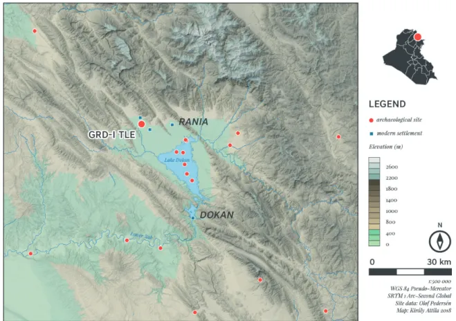
During the works of the first season at Grd-i Tle (Ranya Plain; Fig. 1) in the autumn of 2016 we had set out several different goals, namely to carry out the topographical survey of the site, to establish a reliable ceramic chronology, and finally, to define the location of the Neo-Assyrian layers.
On the basis of the detailed topographical survey of the site2 and the projection of a geodesic grid on the surface three main locations have been established.
In Trench I, situated on the top of the tell, the outer wall of a 18th‒19th century fortress, for- tified with a semi-circular tower, and some of its inner rooms were recovered. Moreover, we were able to identify the antecedent of this structure ‒ which cannot be precisely dated for the
1 Dezső et al. 2016.
2 The geodesic survey was supported by Salisbury Ltd., the measurements were carried out by their fellow worker Attila Weisz. It was also thanks to their support that we had the possibility to use a Leica Total Sta- tion in this season as well.
Fig. 1. Location of the site in Iraq.
time being.3 Also, several successive fortress walls were brought to light in the northern side of this trench (Trench I/A), in the steep slope outside the fortified walls, showing the traces of sieges. Below the stone debris of the Ottoman Period we have identified the rockslide of a Parthian-Hellenistic citadel.4 It turned out that the remarkably steep slope shape of the tell was defined by the consecutive fortress walls. In Trench II, opened at the edge of the middle, south-eastern plateau, several stone lined cist graves of an Islamic cemetery were recovered, their exact dating, however, needs further study. Right beneath the graves a part of a Hellen- istic-Parthian building was excavated.5 Trench III was opened in the lower city, south of the mound. Our investigations here confirmed that the region was heavily occupied during the 18th century.6 At the end of the season 2016, it became clear that the Medieval layers show only an average 1–1.5 m thickness on the top of the tell and in the middle plateau as well, thus it seemed likely that we have a fair chance to reach the earlier layers, including the Neo-As- syrian ones, which was one of the main goals of the expedition.
Excavation works of the second season (2017)
In 2017, works were continued in line with our previous goals. Seven archaeologists and 13 excavation workers were present at the site, two other archaeologists analysed the pottery at the excavation base, while a further archaeologist supported our work from Hungary by means of the creation of 3D models.7 We have widened Trench I (Trench I/A) and simultane- ously deepened Trench II further, and moreover, opened two new trenches (Fig. 2). The reason of the opening of Trench IV in the middle of the northern side of the tell was to complement Trench I and thus quicken the mapping of the stratigraphic sequence, while supporting the establishment of an overall ceramic chronology as well. Besides, we intended to better under- stand the formation processes of the middle plateau. In Trench V, on the other hand, our basic aim was to examine one of the city gates of the clearly detectable town wall to define its age and thus gain a deeper insight into the settlement structure.
According to the practice of season one, the given trenches were set into the 10×10 m squares of the grid, dividing each square into four further sections. The excavation works were con- ducted along 5×5 m units, leaving 0.5 m in each side, so the respective units became 4×4 m in extent, with 1 m wide section walls among them. The labelling of the 10×10 m squares was assigned to the SE point of the coordinate system of the grid, with the addition of the respec- tive, inner location (e.g. 790–550 SW).
The documentation was carried out with a Leica Flexline Ts06plus 3” R500 type Total Station, operated by Nóra Szabó. The excavated surfaces also were subjects of image-based 3D model- ling, elaborated by András Bödőcs in Budapest. Pottery washing was done right on the spot, the cleaned material was sorted and labelled by Fruzsina Németh and Veronika Németh in our Saruchawa base. Outsorted objects were placed in a deposit located in the immediate vicinity of the tell, marked with GPS coordinates.
3 Masek – Mordovin 2016a; 2016b 4 Dezső – Mordovin 2016.
5 Kalla – Szabó 2016.
6 Dezső et al. 2016.
7 The 3D models were made by András Bödőcs.
For the sake of security and preservation, we backfilled all trenches at the end of the season.
The excavated finds were transported to the repository of the Raparin Civilisation Museum (Ranya).
Trench I (790–540 NW, 790–550 SW)
In trench I/A, cut into the northern slope of the tell, works were continued under the direction of Tamás Dezső and Kristóf Fülöp (Fig. 2). Trench I was already opened in the course of the first season in 2016. Trench I/A, being 4 metres wide and 9 metres long and opened at the up- permost part of the northern slope of the tell, actually constituted the first step of a long-term plan according to which, by means of „cutting through” the tell from top to bottom, we may get an overall picture regarding its spatial and temporal formation and structure. The sections of walls, jacketings, domestic structures, and their related layers, excavated on the top of the tell, can be related to the configuration of the yet undated fortress constructed on the top of Fig. 2. Grd-i Tle, the altitude model of the tell and the position of the trenches. The red lines inside the frames illustrate the slope of the tell in NS (on the left), and EW (above) direction. The roman numerals indicate the numbers of the trenches.
the site and its subsequent reuse and rebuilding during the 18th‒19th centuries.8 However, as for the preceding periods, due to the mainly eroded and collapsed features and the objects from various phases from the lower part of the trench, thus far we were only able to gain a sketchily reconstructed picture.9 Thus, for the sake of the more exact definition of the historical sequence of the tell, in 2017 we have widened ‒ in accord with our previous plans ‒ this trench further.
We have opened a 4 m wide and 5 m long section downwards in the slope, in northern di- rection to complement the previous surface, which covered the southwestern part of square 790–550 (790–550 SW). Furthermore, we have re-opened a part of the neighbouring trench (790–540 NW) with 2.5 m length and 4 m width, in order to investigate the connection and extent of certain stratigraphic features (such as SNR 131, 133, 136) on a larger surface (4×7.5 m) and in greater depth, and also to follow and reconstruct the various stone debris.
Features (Fig. 3, Fig. 4, Fig. 5)
The northern slope of the tell was uniformly covered by a 30–40 cm thick, loose greyish-brown layer (SNR 018). This mixed, colluvial deposit contained large amounts of pottery and animal bones, and a few broken iron fragments (wires and sheets) dated from the Bronze Age up until the late Islamic 18–19th century.
On the uppermost section of the tell, the dark brown, more clayey layer SNR 126, with small charcoal and burnt clay particles and starting 160 cm below layer SNR 127 as a rocky debris, ran right until the surface (SNR 018). This tapering (5‒10 cm) layer which ceased to be present at square 790–550 SW could not be observed in 2017, so it could only be reconstructed on the basis of the wall-section.
The dark brown, and also clayey layers SNR 131, 133 and 136, with small charcoal and burnt clay particles and barely differing from each other according to the documentation of the first season, were drawn together on the basis of our observations in 2017, as it turned out that they constitute a single layer (SNR 131). As for the thick (40‒140 cm), dark brown and more solid clayey filling which covered the whole surface of the trench, the dispersion of the burnt clay and charcoal particles was rather unequal, just as that of the small pebbles which appeared more frequently in the upper part of the layer, and more sparsely in the lower parts.
The layer tapered towards the north and ran right until the surface beneath (SNR 018).
In the lower part of layer SNR 131 (150‒160 cm), and consequently somewhat higher towards north (50‒60 cm), an increasing amount of stone debris was observable in the filling (SNR 138). The rubble stones and gravels of various sizes (5‒70 cm) were uniformly and densely dis- persed on the whole surface – with the exception of a 100–120 cm wide section in the middle quarter of the trench (Fig. 7). This debris was evidently coherent and thus consequently drawn together with the stones of layer SNR 136 from 2016 (Fig. 5.1). The space above and between the stones was filled by SNR 131, reflecting contemporality or temporal closeness of the two layers. At the northern end of the trench layer SNR 131 was tapering above the debris and thus the stones were directly covered by SNR 018. As all these features reflect, a part of the debris was once freely dispersed for a long period, constituting, at the same time, the one-time surface of the tell.
8 Masek – Mordovin 2016a; 2016b 9 Dezső – Mordovin 2016.
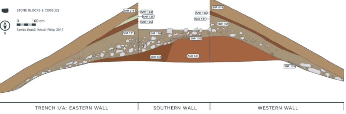
Fig. 3. The eastern, southern, and western section walls of Trench I/A after the 2017 season.
Fig. 4. The eastern section wall of Trench I/A after seasons 2016–2017.
Fig. 5. The western section wall of Trench I/A after seasons 2016–2017: 1 – The coherence of the stone debris SNR 138 with the debris of the layer SNR 136 documented already in 2016, 2 – The location of the Scythian arrowhead recovered in 2016.
The pottery, animal bone, and the few stone tool finds from the layer SNR 131 and from the debris SNR 138 still show a mixed character, however, they did not contain the fragments of terracotta tobacco pipes any more, which were characteristic to the Late Islamic period. At the same time, relatively large number, 21 pieces of metal objects were recovered together with two glass objects, 19 of them were found in situ while 4 pieces came from the soil heap.
The largely uniform distribution of the objects in the upper part of the filling, together with the types and character of the objects10 well reflect the mixed nature of this layer. However, one has to note that the baked brick and tegula fragments found among the stones of the debris, as well as the appearance of more specific ceramic types in increasing number clearly point to a Hellenistic-Parthian dating.
After the removal of the stones of debris SNR 138, the stones ceased to be present in the west- ern part of the trench and the debris gave place to layers SNR 139 and 140. By contrast, in the eastern part the stone collapse remained detectable through a further, 50‒60 cm depth, for and aft of the trench, although its thickness gradually decreased towards the north (Fig. 8). All this may confirm our previous observation regarding the presence of the south-north oriented depression running in the eastern part of the trench. However, over against our earlier sug- gestion, it also became obvious that this recess is much more remarkable in size as previously taught, and, moreover, that it was formed well before the Late Islamic period.
At the western side, beneath the stone debris a 5‒10 cm thick, dark brown clayey layer (SNR 139) containing small (1‒4 cm) pebbles were observed at several places (see the western part
10 9 iron nails, 2 iron clots, 2 iron wires, 1 bronze nail, 1 bronze arrowhead, 1 bronze belt buckle, 2 bronze frag- ments, 1 bronze clot, 1 bronze sheet, 1 copper coin, fragment of a glass armring, 1 glass bead.
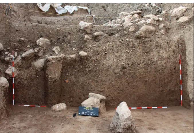
Fig. 6. The southern section wall of Trench I/A.
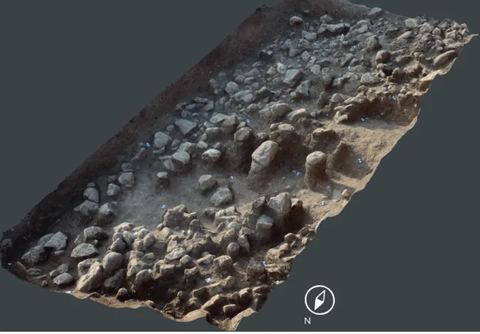
Fig. 7. The stone debris (SNR 138) covering the whole surface of Trench I/A (SNR 138).
Fig. 8. The stone debris (SNR 138) which fills the depression running along the eastern side of Trench I/A and the solid clayey layer appearing in the western side (SNR 140).
of the southern, and some parts of the western section wall). In spite of its loose distribution, the pebbles were prominent during the disinterment and in the wall-section as well and there- fore it has to be considered as a separate layer.
The South‒North oriented depression can be well reconstructed, not only on the basis of the scatter of the stones, but also, in view of the clear separation of the subsequent layers. In the western side of the trench, a more coherent, brown and more solid clayey layer (SNR 140), with small charcoal and burnt clay particles, was observed beneath SNR 138 and 139. The fill- ing showed a clear change with respect to its character and the finds, since over against the younger layers (SNR 018 and 131) it was characterized by more uniform pottery finds ‒ which, according to our preliminary investigations, can be dated to the Hellenistic-Parthian period ‒, and also by a few flints and animal bones. At this level both the brick and tegulae fragments ceased to be present. Moreover, the former large amounts of mixed metal cut-offs disappeared as well, only a single iron clot was brought into light from this layer.
By contrast, in the eastern part of the trench a dark brown, fat and solid clayey layer (SNR 141),containing small (<1 cm) pebbles, charcoal particles, and at times even with rather large (<4 cm) burnt clay fragments was observed beneath the stones of the debris (SNR 138), as the filling of the recess. At some places the friable clay clods which were not so thoroughly burnt pigmented the dark brown filling with a red colour. Beside the pottery and animal bone finds similar to that of SNR 140, 3 bronze fragments were recovered in here. On the basis of the finds, layers SNR 140 and 141 laying side by side cannot be differentiated on chronological grounds, however, due to the evidently distinct character of the fillings we have to consider them as separate features and events.
Our present work was brought to an end at 310‒340 cm depth measured from the surface in the southern side, on a horizontal technical level belonging to layers SNR 140 and 141.
Conclusion
Although built structures or in situ objects had not been unearthed during the 2017 season, several aspects of the formation process of the tell became clear to us.
On the basis of the characteristics, the extent and uniformity of the SNR 138 stone debris, prob- ably dated to the Hellenistic-Parthian period, we may detect the traces of an intentional de- struction. Subsequently, some parts of this deposit were overlaid by younger occupational lev- els, while further north from the central area of the tell the stones were and remained scattered on the surface for a long time. These stones of various form and size may originally formed part of walls or other built structures on the top of the tell. As the great extent and varying depth of the stone dispersion suggest, some part of the stone debris recovered in 2016 can also be connected to this „collapse event”. At the same time, the dark brown, clayey layer SNR 131 may have been overlaid the stone debris as the material or bedding of some kind of built structure, or by means of other, such as landscaping processes. As the upper, rather mixed parts reflect, certain sections of this layer may have constituted the surface of the tell for a longer period.
The other significant result is the depression in the eastern half of the trench, running in South-North direction, which most visibly manifests itself on the southern section wall (Fig. 3, Fig. 6). The formation of the recess can be dated well before the Late Islamic period, and, ac- cording the present state of the excavation it was already present in the Hellenistic-Parthian
period. Although we cannot draw well-defined conclusions regarding its function, its extent and orientation make it rather possible that it was a passageway or ramp leading towards the upper, central part of the tell.
The position of layers SNR 140 and 141 clearly signifies that we have not reached the bottom of the recess yet. At the same time, both the great thickness of SNR 140 (140 cm at present) and its remarkable homogeneity may suggest that we are dealing with the remains of an in- tentional filling or perhaps of a rammed wall (Fig. 6). However, all these suggestions, just as the physical and temporal relation of the two fillings need further investigation and explana- tion in the future seasons.
After the first two seasons of the excavations carried out in 2016‒2017, trench I/A allowed us an insight to the structure and the formation process of the tell to a depth of 40‒340 cm11 in the length of 14‒15 metres in South-North direction (Fig. 4, Fig. 5). However, due to the specific position of the trench, this part of the tell is characterized by eroded layers and stone slides and thus far no built in situ structures were brought to light in here. Nevertheless, the observed features, the character and the location of the finds, together with the testimonies of the section walls well reflect that a yet undateable fortress was constructed on the top of the tell. It was rebuilt some time during the 18th century as a result of the escalating armed conflicts between the Ottoman and the Persian Empire. The traceable activities were con- centrated to the top of the tell during the 18‒19th centuries, since no landscaping activity or related structures were observed further north, in the slope of the tell. After the Late Islamic
11 The measured depth from the top of the tell is 740–840 cm at present.
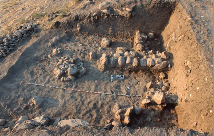
Fig. 9. The walls of the Hellenistic-Parthian period building and the stone construction SNR 72. The photo was taken from the north.
period, the tell was unoccupied for a long time at least in the area of trench I/A. The traces of the underlying period suggest a Hellenistic-Parthian date (in part SNR 131, 138, 139, and also SNR 140, 141), when significant landscaping activities were carried out in several parts of the tell ‒ which, all at once, fundamentally defined even the modern day appearance of the site (see Trenches II and IV). Finally, the Scythian arrowheads and the fragment of a bronze bowl found in 2016 among the stones in the border of the dark brown, solid layer SNR 137 lead us back even until the 7‒6th centuries BC. (Fig 5.2).12
According to our original plan, we aim to extend the trench to the northern direction in the upcoming, 2018 season, and continue the deepening in squares 790–540 NE and 790–550 SW to get an overall picture on the structure and the temporal relations of the tell.
Trench II (850–480 SE)
Introduction
By the eastern side of the tell, the work of the previous season was also continued in Trench II, opened at the edge of the middle plateau, with the direction of Gábor Kalla (Fig. 2). During the present season, we have deepened the surface of this trench with an average 1 metre. The fact that the given features laid rather closely beside and above each other remarkably slowed up our work, and moreover, it was rather difficult to distinguish the stones which remained in their original place from the ones mixed up in the filling. The excavated features can be dated to the Hellenistic-Parthian period.
12 Dezső – Mordovin 2016, 246–248, 250, Fig. 16: 1–2; See article of T. Dezső in the same volume: Dezső 2017.
Fig. 10. The walls of the Hellenistic-Parthian period building and the stone construction SNR 72.
Therefore, it was the approximately 2 m long and 50 cm wide EW oriented wall (SNR 78), constructed from limestone blocks of various sizes and soil, which showed the most co- herent picture. At times two, while in other places one rows of stones remained detectable from its superstructure. This wall was intercepted by another one (SNR 86) 50 cm far from the western trench wall, running in line with the latter. The width of the intercepting wall was 40 cm, and similarly two rows of its stones were detected. The two walls, however, were not connected to each other, and the straight ending clearly suggests that they were constructed in different periods. No traces of paving could be observed in the area enclosed
13 Kalla – Szabó 2016, 275.
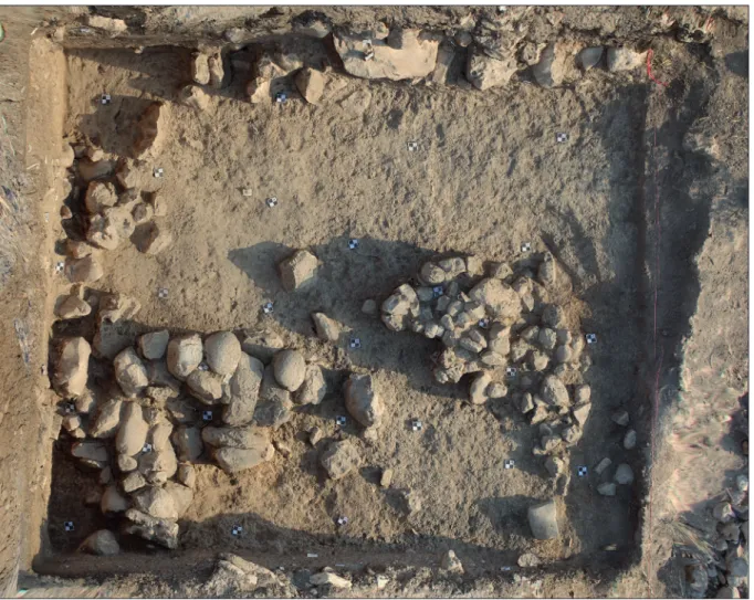
Fig. 11. The foundations of the Hellenistic-Parthian period building.
by them. Theoretically, these two walls can be interpreted as foundations, however, as two identically oriented, but much more irregular stone-built wall sections were recovered be- neath them (SNR 94 below SNR 87; SNR 86A below SNR 86), the latter can more plausibly be considered as parts of a foundation (Fig. 11). Among the constituting stones there were large cobbles (25‒30 cm) and larger, at times even 50 cm long rubbles. The foundation SNR 86A beneath the cross-wall SNR 86 was not so distinct from the former as in the case of the other wall and its base (SNR 87 and SNR 94).
In 2016 we already observed a feature rowed with smaller stones in the NE corner of the trench which seemed to be a section of a rammed wall (SNR 85), running in SW‒NE direction, differing from the orientation of the building. As it was brought to light in a heavily eroded state we could not identify its outlines. Upon deepening the area, it turned out that an aligned, irregular stone row (SNR 93) was running beneath it, consisting of various sized stones which sometimes did not even joined each other some of them were placed in upright position, and on the whole along a rather bent line. According to this year’s observation it is more likely that we are not dealing with a wall of a building, but rather, with the founding of a circular stone construction ‒ similar to the ones found to the south and the east. Two of the latter (SNR 97 and SNR 86A) laid directly beneath the foundation of the building.
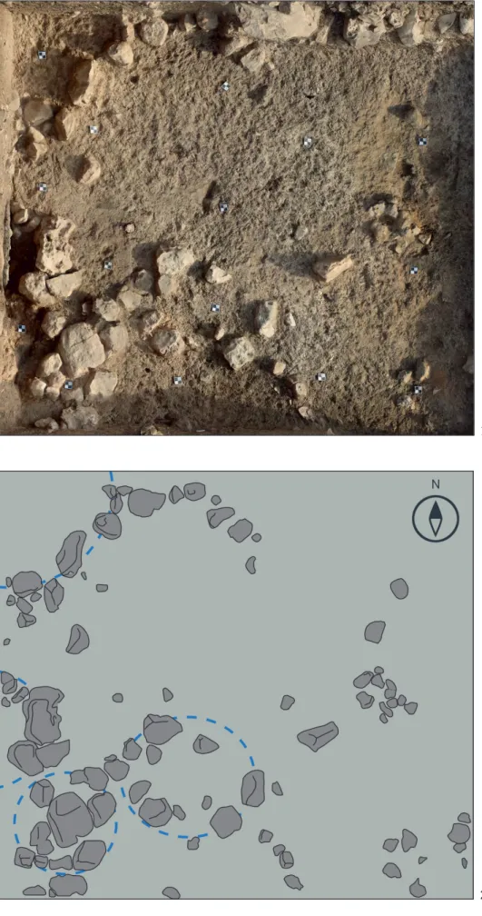
The circular or oval stone constructions with elusive outlines (SNR 97, SNR 98, SNR 99; Fig.
12) were more or less similar sized, confined with a single row of stones and in most cases empty in the inside. Their borderlines remained ambiguous, since stones of comparable size were present in the filling as well. One of the stone circles (SNR 97) was located right inside the western wall, under the wall SNR 94, the diameter of its excavated part was approximately 90 cm. As for its walls, at times even two successive rows of stones remained visible.
Upon ablation of the wall SNR 86A, laying South of this feature, a further stone circle (SNR 98) was recovered. It is still uncertain whether we are dealing with an individual construction, or it rather formed part of the wall running above it. It was 0.75×0.90 m in extent and a single, large sized stone block (44×37×20 cm) was found in its middle. Perhaps the presence of the latter was merely coincidental, however, we may also suggest that by this analogy originally all such constructions may have contained similar stones.
To the east from the latter, the stones of the circle, located some 1 m far from the trench wall were much sparsely placed as those of the constructions SNR 97 and SNR 98. This circle was larger than the latter ones (1.40×1.15 m), and we found the fragment of a secondarily used basalt saddle quern among its components.
The stone circle SNR 97 was placed directly on a rectangular structure (SNR 401A) made from throughout baked, flat clay fragments, only the smaller part of which penetrated into the trench. The extent of this excavated part was 1.6×0.5 m (Fig. 12). It is possible that originally it may have served as the foundation of a raised platform. Perhaps it was constructed from the ruined walls of an industrial kiln, since while one side of the fragments was flat, the other regularly showed the traces of coil building technique ‒ with unfinished coils. Identical pieces were found in much higher levels as well.
As for the fillings of the area enclosed by the walls of the building (SNR 88 and SNR 91), the layers inside and around the stone constructions (SNR 89 and SNR 90), and the overlying lev-
Fig. 12. 1 – Orthophoto of the circular stone constructions, 2 – Drawing of the circular stone con- struction.
1
2
els (SNR 67 and SNR 74), their material proved to be surprisingly identical. The characteristi- cally beige coloured, coherent humus soil contained small burnt clay pieces in large amounts and charcoal particles as well. Moreover, iron skimmings and glass-like clots were also prom- inent in this filling. Perhaps the latter can be interpreted as by-products of iron smelting.14 On the basis of all this it is rather possible that the circular installations were related to some kind of industrial activity carried out in here, and that some of them were the foundations of kilns demolished some time later on.
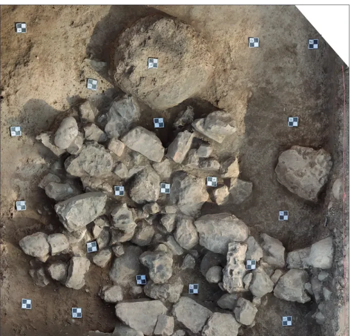
In the eastern side of the trench the remains of a circular stone construction (SNR 72), 1.5 m in diameter, were visible already on the surface (Fig. 9). By contrast to the circles of the west- ern side, the stones of this one were rather tightly set. Most probably it was an Islamic period construction which destroyed the eastern wall of the Hellenistic-Parthian building. Going deeper, this construction was still traceable but its size increased towards East and instead of being circular, it took an oval form.
In the SE corner of the trench, upon deepening the surface and the demolishing of the con- struction SNR 72, a tightly rowed section, consisting of multiple rows of stones appeared directly beneath a surface without features (SNR 401, Fig. 13). It was approximately 2×1.5 m in extent and featured an irregular outline. Right next to it the foundation of a circular kiln (SNR 402), 0.8 m in diameter, was brought into light. The colour and the consistence of the surrounding soil (SNR 400) differed from the features of the filling in the western part of the trench, it had a darker brown colour and was rather friable. At the eastern third of the surface there was a well perceptible transition between the two kinds of fillings, also visible in the section wall, on the basis of which we may suggest that the eastern part was dug in some- what later however, judging by the size of the stones, around the same time when the western building was built. The proper function of the construction is unclear, it is not unlikely how- ever, that it can be connected with the drainage of the terrace.
According to the preliminary investigations the pottery recovered in this trench during the second season can, at most part, be dated to the Hellenistic-Parthian period (Fig. 14), however, this material was mixed up with several earlier, among others Chalcolithic (Ubaid and Halaf) fragments.
The dating of this layer was already confirmed by the Macedonian silver coin found last year,15 as well as by the tegulae and their fragments which also belonged to this cultural tradi- tion. As for the metal objects, we should mention, beyond the iron pegs, the bronze nails and smaller bronze fragments as well.
As extraordinary finds we should also mention the two small isolate lapis lazuli objects, name- ly a flat discoid and a flat rectangular bead (Fig. 16.1, 4). The former is a wholly usual form,16 while the latter is much more rare. They were furnished with three perforations, presumably for slipping the thringing wire through, and, just as the other similar plates, they may have been spacer beads (Fig. 15). A close parallel is known from Kassite Nippur,17 the rectangular
14 We are grateful for this observation to Zoltán Czajlik.
15 Dezső et al. 2016, 239, Fig. 7.
16 See Casanova 2013, 175.
17 McCown – Haines 1967, Pl. 150, 2.
lapis lazuli bead found in here had likewise three perforations and its size is largely identical as well. Since there were later, Neo-Assyrian diggings in the layer in which it was found (TA 127 VI),18 it is hard to define the exact date of this type.19 We may get closer to the dating of this rare form if we take into consideration the spacer beads of one of the necklaces from the famous Assur burial vault 45 (Gruft 45 = grave 14630).20 The latter differs from our find with respect to the fact that in here the front side of the lapis lazuli plates was divided into four ribs by three recesses, and they had only two perforations. Another significant difference is that in our case we should reconstruct a necklace with much smaller beads as, on the basis of the
18 McCown – Haines 1967, 69–70.
19 Lapis lazuli spacer beads, although in a different form, were rather frequent during the IIIrd millennium BC, later on, however, they became remarkably rare (Casanova 2013, 183–184). Michèle Casanova distin- guished two main groups of the rectangular beads, one of them is ingot formed, he does not mention multi- ple perforations (Casanova 2013, 180)
20 For the Assur grave 14630 (Gruft 45) and its finds see most recently: Pedde 2015, 89–95, Taf. 59–63, with the mentioned necklace in Taf. 62: top.
Fig. 13. Stone construction (SNR 401) in the SE part of Trench II.
spacer, the three rows may have been altogether 1.5 cm wide while the spacer from Assur di- vided two rows with an altogether 2.4 cm width.21 A further flat lapis lazuli bead which is also similar to the Grd-i Tle piece comes from another necklace of the same Assur grave.22 Taking the functional similarities into consideration, it is reasonable to (cautiously) date the bead to the Middle Assyrian period. This would correlate with the Kassite dating of the Nippur bead as well. Furthermore, a biconical cornelian bead (Fig. 16.2) was also recovered from this layer, however, as this type was widely used in various periods, it cannot be precisely dated.
Among the extraordinary finds we should also take note of the fragment of a late Ubaid cylindrical shaped figurine (Fig. 16.6). This object, made of a remarkably fine material and burned to get a characteristic greenish colour represents black rows of different width, care- fully painted on the well finished surface. Its lower part ends in a stand which is hollow at its middle, while it may reflect the traces of deliberate fragmentation on its upper part, since it seems so that the upper part was detached due to hits coming from various directions. Per- haps it was the lower part of a female figurine,23 but we cannot rule out the possibility that we are dealing with a fragment of a terracotta peg.24
Knapped lithics, well represented in various other stratigraphic units as well, are further evi- dences regarding the mixed nature of the finds coming from these layers.25
Conclusions
The middle plateau located on the eastern side of the tell yielded, directly beneath the Islamic layers, remains of Hellenistic-Parthian buildings in Trench II we recovered the corner of such a construction. Its foundation walls were made from large rubble stone blocks cemented with soil and clay, and the pedestal walls were executed in a similar way. Its superstructure may have made from rammed earth or baked bricks, however, its remains are lost. Due to the rel- atively small extent of the recovered surface its proper function cannot be determined for the time being, so we cannot tell whether it was a private or public building. The lack of mortar usage is rather conspicuous, this phenomenon is also already known from Parthian period Assur.26 Perhaps it was a regional characteristic, although rubble masonry was widely applied in this region both in ancient and later times.27
The circular stone installations were certainly earlier than the building itself, but perhaps they were still in use in the time when the latter was built. Their proper function is also uncertain, especially since only a rather small part of them survived. It seems likely that their building material was reused already during antiquity and later times as well.
The filling around the buildings and the installations is a quite specific feature. The numerous charcoal and burnt clay spits, the iron skimmings and the presence of glass-like clots, that is, characteristic by-products of ironworking clearly suggest that some kind of industrial activity
21 For a good illustration and description of the first Assur necklace see: Jacob-Rost et al. 1992, 157; Harper et al. 1995, 95, Pl. 11: top.
22 For the second Assur necklace see: Jacob-Rost et al. 1992, 155–156; Harper et al. 1995, 94, Pl. 10.
23 On the Ubaid figurines see recently Daems 2010, and regarding our exemplar see esp. Fig. 9.1.c, e, ‒ note, however, that we are not dealing with an exact parallel.
24 For a similar piece see: Woolley 1955, Pl. 15, U. 18297.
25 See the study of Attila Király in the present volume: Király 2017.
26 On the foundations of the Parthian houses at Assur see: Andrae – Lenzen 1933, 8.
27 Naumann 1971, 65–68; Wright 1985, 397–400.
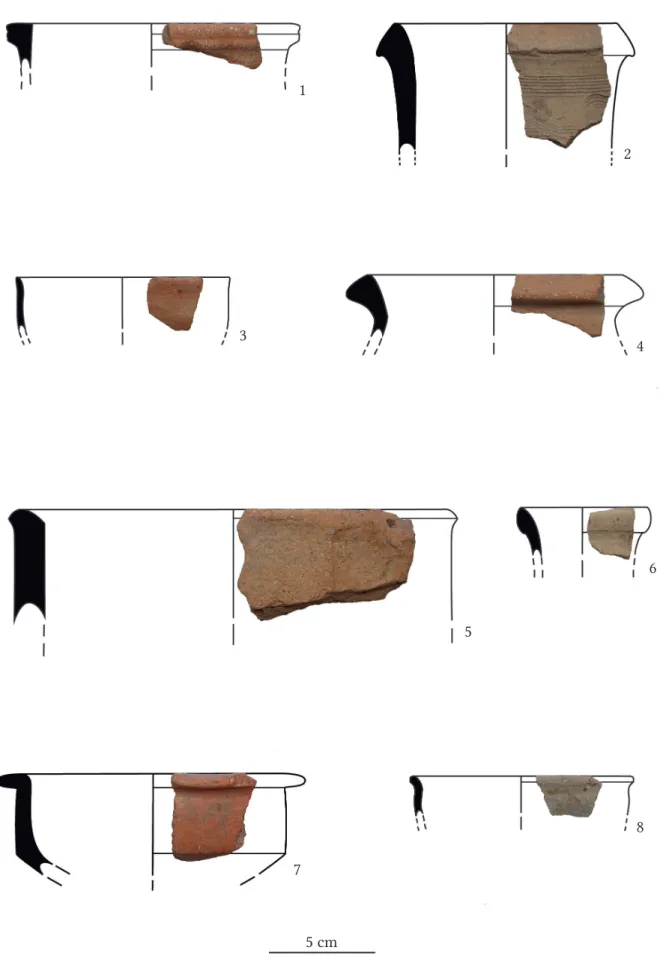
Fig. 14. Pottery from Trench II (1, 5, 8: SNR 400; 2, 3, 4, 6, 7: SNR 090–091). The stratigraphic units appear in brackets.
5 cm
3 4
5
6
7
8
was carried out in the close vicinity. Therefore, it seems possible that the circular installations can be connected to this phenomenon and should be interpreted as the foundations of indus- trial kilns. Scattered fragments from the side walls of such a kiln or kilns were found at several places, and moreover, we recovered a whole pedestal made from these pieces.
As further characteristics we should note the several small Chalcolithic (Halaf and Ubaid) pottery fragments and knapped lithics which were present in each level, in more than 1 m thick layers. Upon taking the likewise earlier lapis lazuli and cornelian beads into consider- ation as well (Fig. 16.1–2, 4) we may assume that the stratigraphic sequence was heavily dis- turbed some time during the Hellenistic-Parthian period. It seems so that vast amounts of soil were moved during the construction of the terrace and at times even the prehistoric layers and Middle Assyrian graves were disturbed in the curse of this process. Perhaps the same can be said about Trench IV, where the fragment of a calcite bead was brought into light (Fig. 16.3).
Probably it was the very same period during which the approximately 30 m wide middle plateau was created in its present form. The terrace was supported by a retaining wall in its eastern side probably it formed part of a fortified girdle of walls the traces of which are still visible on the surface.
At the eastern part of the surface, an irregularly shaped stone construction with dry stone walling and tightly set stones was revealed, the function of which is also uncertain, although it resembles to the funnel-shaped feature of Trench IV (Fig. 18) in many respects. As one pos- sible interpretation, we may assume that it was used for drainage purposes, to protect the wall from the erodent effects of rainwater.
Trench IV (780–570 NE)
Trench IV was opened, with the direction of Attila Király, on the eastern side of the tell in the NE part of square 780–570 (780–570 NE; Fig. 2). The 4×4 m trench was excavated to a depth of 320 cm from the surface, measured from the SW corner. At the NE corner we traced the layers to a depth of approximately 60 cm from the surface; the remarkable difference between the depths is due to the steep slope of the side of the tell. The works of the 2017 season were brought to an end at a flat technical level.
Fig. 15. Rectangular lapis lazuli spacer bead with three perforations (SNR 090).
Fig. 16. Small finds from Trenches II and IV: 1 – cornelian bead (SNR 074), 2 – lapis lazuli bead (SNR 090), 3 – calcite bead (SNR 203), 4 – lapis lazuli bead (SNR 067), 5 – sculpturesque frit moulding (SNR 202), 6 – fragment of an Ubaid figurine (SNR 091). The stratigraphic units appear in brackets.
3 4
5
6
Features (Fig. 17)
The approximately 30 cm thick uppermost, evenly distributed level (SNR 200) is the root zone of the grassy vegetation, mixed up with finds, mostly pottery fragments from various periods.
Below this surface layer a brown coloured, hard and clayey layer was recovered through the bottom of the trench with three, almost indistinguishable accumulation events: SNR 202A (between -30 and -160 cm from the surface at the SW corner); SNR 202B–C (-160–280 cm);
SNR 203 (-280–320 cm). Upon getting deeper, the compactness of the matrix slightly increased which can be considered as a post-depositional phenomenon of natural origin. The transition between the layers SNR 200 and 202 was explicit, barely detectable and rather elusive inside SNR 202. Beneath SNR 202, a 1–5 cm thick, distinct layer was observed with charcoal and ash (SNR 207), followed by the underlying SNR 203 stratigraphic unit.
The stratigraphic unit detected in the SW quarter of the trench in a depth of -30 cm from the surface (SNR 201) was similar in colour and texture to SNR 200. A large amount of debris were dispersed and accumulated throughout this layer: rubble, cobbles, and brick fragments of 20–50 cm sizes. The matrix which integrated these debris became more compact in texture and lighter in colour in the deeper regions (SNR 206). The extent of these two stratigraphic units were restricted to a funnel-shaped cavity inside the trench.
In the SW region of the trench this funnel-shaped cavity appeared close to the surface, it had a 200×150 cm extent there and shrank downwards right until the bottom of the trench (Fig.
18). This cavity was filled with the stone debris of SNR 206 and 201, its proper role remained unknown, however, it cannot be ruled out that it may had some kind of a drainage function.
In a -280 cm depth measured from the surface of the SW corner a dry-stone and brick walled foundation was brought to light (Fig. 19). Getting in from the eastern wall of the trench this Fig. 17. Grd-i Tle, section drawings of Trench IV. For the description of the stratigraphic units see the main text: 1 – An area heavily filled with debris of stones and brick fragments, not every piece is indicated on the drawing, 2–3 –lighter fill which defines SNR 202B in the south wall and the thin limy lamina above it, 4–5 – SNR 207 appearing as a thin lamina of charcoal on the southern, and in an ashy, friable way on the western section wall, FEA001 – The cavity filled with debris, FEA002 – The sciagram of the stone foundation of the wall on the section wall.
Fig. 18. The axonometric model of Trench IV.
Fig. 19. Feature 2 viewed from above.
structure ran for an approximately 300 cm length in largely E–W direction, that is, it did not reach the western trench wall. The northern and southern edges of this 100 cm wide and 30–
40 cm high structure were paved with large sized rubbles. The space between the edges was filled with smaller stones and brick fragments set in more or less regular rows. The eastern section of this foundation was interrupted by a 40 cm wide doorstep made from large angular quarry blocks.
As the evaluation of the recovered artefacts is still in progress we can only summarize some preliminary observations here. Predominantly, our finds consist of pottery sherds represent- ing multiple periods in each stratigraphic unit. SNR 200 and 202 are characterized by Islamic and Hellenistic-Parthian pottery. In the deeper sections, especially in SNR 203 the Islamic finds were replaced by Assyrian domestic pottery although the majority of the artefacts were Parthian period sherds. At the last technical level of the 2017 season we observed, in an ap- proximate 320 cm depth, pottery sherds which can be dated to the Chalcolithic Period.
Each and every layer contained bones of ovicaprids and canines, evenly dispersed in the whole trench. Mollusc shells were also detectable, even in a great amount in the stratigraphic unit SNR 203. Moreover, each unit yielded knapped lithics and ground / polished stone items.
Most of these can be dated to Prehistoric periods, they may have gotten in here due to the disturbance of the layers, with the soil used for filling (see the related report). Metal finds were represented by a single exemplar, namely an iron peg. Furthermore, a rather specific find of the present season is the faience plaque from SNR 202 (Fig. 20). While the reverse of this 50×30×10 mm fragment is roughly finished, the obverse represents a swell with a paraboloid silhouette emerging from the flat surface, with a narrow end which remained intact and with a flaring part which is broken. A shallow groove runs along its long axis ‒ resembling to the tight-drawn legs of a front-view female figurine ‒ which can be traced on the fragment until the height of the knees.
Fig. 20. The faience relief fragment found in the stratigraphic unit SNR 203.
structural elements of the wall, nor its method of construction facilitate us to define its exact date. On the basis of the related pottery finds, we may date the fortification either to the Hel- lenistic-Parthian, or perhaps to the Neo-Assyrian period. The occupation level of SNR 203 was followed by a thin destruction layer with charcoal and ash (SNR 207).
The subunits SNR 202C and B continued to accumulate almost horizontally. The border be- tween them was marked by a slight difference in colour, and a limy spit seen on the southern wall-section. The inclination of subunit SNR 202A became somewhat steeper, which may al- lude to a quick layer formation. The funnel-shaped cavity starts from the top of this unit, and it was subsequently filled by the stone debris of SNR 206 and 201 in the SW section of the trench.
After the formation of the debris the mantle of the tell (SNR 200) closed the stratigraphic se- quence. As for the supposed short-time accumulation of the layers SNR 201, 202, and 206, we should also note that the artefacts from all of these stratigraphic units are rather similar.
According to our present state of knowledge this section of the tell was fortified. The solid wall recovered in Trench IV was interrupted, which suggests the presence of an entrance ‒ thus it seems likely that we are dealing with one of the gated of the middle girdle of walls.
Trench V (840–390 SW; 830–390 NE)
Introduction
During the 2017 season a new trench was opened in the lowest plateau on the southeastern side of the tell, close to our previous Trench III,28 laying slightly southeast from the latter (Fig.
2). The excavation was supervised by Ardalan Khwsnaw and Aram Ali Hama Amin. The basic goals of the opening of Trench V were to investigate a city gate which seemed identifiable even on the surface, and to reveal its structure and chronology
In 2016, a city wall which presumably encircled the lower plateau of the tell was already identi- fied during the survey of the tell and its environment.29 The detailed survey of the exact line and structure of this wall made from large sized quarry stones, many of which are even observable on the surface of the tell and in the other trenches as well will be the task of the future seasons.
However, on the basis of the trench survey it can already be assumed that the structure of this wall was consisted of straight sections and obtuse-angle corners. Starting from the southern side of the mound, the traces of the structure can be followed right until the northeastern and the western sides of the tell ‒ although the latter was heavily disturbed by a modern fishpond.
28 Dezső et al. 2016, 240.
29 Dezső et al. 2016, 236, Fig. 4.
Fig. 21. 1 – 3D model of the wall in Trench V/A (SNR 303), 2 – The wall of the lower town (SNR 303).
The photo was taken from the west.
1
2
hind a small elevation and we also could detect a slight curve on the modern channel. That cannot surely be related to the former structure of the town wall, although it is interesting, that the otherwise straight watercourse breaks in this point. We outlined a trench here, in the area of the presumed city gate in the southwestern corner of SQR 840–390. Its size (3,5×4 m) differs from the others because of the close vicinity of the channel (Fig. 21.2). Later, we outlined another, 4×4 m trench (830–390) as a result of the discovery of a wall running in a northwestern-southeastern direction in SQR 840–390 SW. We carried on with the research in its northeastern corner.
Excavated features
Trench V/A (840–390 SW)
Although several large sized stones were brought to light from the clearance layer of trench 840–390 SW, they were removed as they did not constitute any coherent structures. At the bottom of the brown, mixed layer (SNR 300) which covered the surface of the southwestern sloping trench with varying thickness (10–35 cm), we were able to detect the line of a wall (Fig. 21.1), run across the square in NW–SE direction (SNR 303).
The outer sides of the circa 130 cm wide wall (SNR 305) were built of large sized stones placed some 75 cm far from each other, the space between them was filled up with earth. On its northeastern side, beside SNR 302 it consisted of a row of large (5–20×30–35 cm) stones, while on the southwestern side, beside SNR 301 three rows of smaller (25–30 cm) stones were brought to light. The difference between the two sides of the structure is unclear yet, it can be supposed, that this specific layout corresponded with the slope of the plateau of the tell, or, alternatively, was a result of infilling.
The wall intersects the trench by a straight line, except in the southeastern side where seem- ingly an arch can be observed ‒ which can even be traced beyond the trench, running towards the east for a further 1.5 metres. Although one may expect with good reason from this arch to join with the wall encircling the lower plateau, however, they converge not in right angles, rather unexpectedly, in a 135° angle. The wall left the excavated area in the northwestern corner, and therefore, to follow up its line, we opened an additional trench in this direction (830–390 NE). Towards the northwestern corner of trench 840–390 SW we observed minor hi- atuses between the stones in each side, however, these cannot be considered as closures since further stones belonging to the same wall are clearly visible in the section wall.
Below the topsoil layer (SNR 300) we recovered mixed fillings on both sides of the wall. Just as SNR 300, these filling layers (SNR 301; SNR 302) yielded various finds, however, in this case
we treated these layers separately from the uppermost level. In the southwestern side of the wall the filling (SNR 301) was consisted of dark brown coloured hard soil which was mixed with approximately 5–10 cm large white stones and pottery fragments. The 35–40 cm deep feature (SNR 301) lays between the upper and lower flat levels of the wall. The subsequent SNR 304, lying beneath the stone wall was largely mixed, the brown coloured soil was full of smaller and larger charcoal pieces and yielded several areas of heavy ash concentration.
Upon demolishing this layer, a solid, thoroughly burnt surface was observed in the middle of SNR 304, between the intersecting wall and the northern section wall of the trench. Also, we detected the ruins of a fireplace or kiln (SNR 304A) with rather ambiguous layout, with its pieces scattered around. As compared to the latter one, another, relatively massive kiln (SNR 304B) was found close to the northern part of the section wall, in this case the burnt side wall was still observable, and we detected a 3–4 cm deep ashy layer in its inside. South from this feature, the soil was rather ashy and loose and contained the burnt pieces of the one-time wall of the kiln. Beside the pottery fragments, an iron peg was also revealed in here.
The dark brown coloured filling in the northeastern side of the wall (SNR 302) was also mixed and beside pebbles, at times it contained burnt clay pieces and pottery fragments as well. Just as on the right side, we followed this layer until the bottom of the wall, up to 50 cm depth. The larger stones which became visible in the lowest part already belonged to the subsequent lay- er, SNR 306. In SNR 306 which lays beneath the wall yielded some irregularly placed stones, quite similar to those which constituted the wall, so perhaps they fall down from the latter’s upper levels. However, as SNR 306 laid beneath the lowest stone row of the wall it is more likely that the stones recovered here belonged to its earlier phase. From the filling between the stones, a piece of slag and a fragment of a pipe were brought to light.
Fig 22. Foto of the end of the city wall or a gate (SNR 352) and the remain of a large sized kiln (SNR 355) in Trench V/B.
light from SNR 351, this heavily disturbed layer yielded numerous pottery sherds, animal bones, burnt clay and slag pieces as well.
In the lower part of the layer, a section of a wall was observed in the southwestern cor- ner. On the basis of its orientation and the character of the large rubbles of this dry stone walling (SNR 352) it can clearly be considered as the continuation of the wall in the former surface of the trench 840–390 SW ‒ although the construction of its structure is somewhat different (Fig. 22). In this case we are not dealing with two side-walls filled up with earth among them, but rather, a massive structure exclusively made from stones. This wall ran around 1 metres towards the middle of the trench where it ends ‒ perhaps this is the very reason behind the differences of the walls in the two squares (SNR 303 and SNR 352). As this structure only slightly extends into the square 830–390 NE, we could not reconstruct its actual layout ‒ or function. It might be the final closure of the wall, but it cannot be ex- cluded, that it turns and continues to the northeastern direction.
Fig. 23. Hinge stone of a gate found at the western part of the lower city.
The border between layer SNR 351 and the subsequent SNR 353 was definite with regard both to their different character and colour. At the transition between them, we were able to de- tect a rather hard surface, perhaps a floor level. The layer SNR 353 began at the height of the lower stones of the wall. In a depth like this we could no longer expect the possible traces of agricultural disturbance. In a large sized area at the middle part of the trench, we recovered smaller, 5–10 cm sized stones lying close to each other, which exact function could not be de- fined, as they could either represent the floor level of a building or the remains of a road. The archaeological finds from this layer contained several metal objects, among others an iron pin and a horseshoe. Between SNR 353 and 354 another fairly hard surface was detected. SNR 354 contained further pottery sherds, animal bones, and pieces of pipes. A definite burnt section, running from the southwestern towards the northeastern corner was already observable in the overlying level (SNR 353), at this point, however, it became clear that in fact we are deal- ing with the remain of a large sized (175×115×21 cm) kiln, in the vicinity of which numerous pipe fragments and iron pins were found (Fig. 22).
Upon digging deeper, the great amounts of metal finds continued to be present, and beside the characteristic objects which were already detectable in the overlying levels, a bronze ar- rowhead was found in SNR 356. In the eastern part of the trench, the stone covering of the stratigraphic unit SNR 354 was still visible, while the stones became more scattered in the western part, as in here we recovered a subsequent filling layer.
In layer SNR 357, close to the southern trench wall, two, perhaps once coherent walls (SNR 358; SNR 361) were brought to light. Although we did not have a chance to clarify the exact setting and function of the stones in the present season, it is highly probable that they formed part of a building or a wall which intersected trench 830–390 NE in northwest-southeast di- rection. The same layer yielded a further kiln in the southeastern part of the square, although it was more modest in its size (65×75×8 cm) than the overlying one. Also, great amounts of accumulated animal bones were found in the immediate vicinity of this kiln.
Our last layer, SNR 360 contained, beside the large amounts of metal objects characteristic to this square as a whole, further smoking pipe pieces and a glass fragment as well.
Conclusions
The exact interpretation of the wall sections excavated in the two areas of Trench V, opened in 2017, is undoubtedly the task of the next season. Our initial assumption, according to which we are examining the area of a city wall gate, still has to be confirmed. Although the structure of walls SNR 303 and SNR 352 (Fig. 21, Fig. 22), brought to light in Trenches V/A and V/B is rather similar to the wall encircling the settlement and observable on the surface, and moreover, their respective width corresponds as well, their inherence still needs to be proved.
A further difficulty in defining the exact relation of the excavated section and the city wall as a whole lies in the fact that over against our expectations they do not join each other in right angles. Apart from these facts, it is still possible that we found a gate which was opened towards a road coming from the south. However, to prove this supposition, we still have to examine the wall on the left side of the gate.
The wall section recovered in square 830–390 NE raised further problems, since in this case we are dealing with a completely different construction and therefore we cannot ascertain that it was the closure of the wall, or, as the latter bends in here towards right, that it should
ing the previous season may provide further reference points‒as their structure is relatively similar to the city wall recovered in Trench V.31
In spite of all that, we still cannot exclude a possible Hellenistic-Parthian period dating. Most of the pottery sherds found in 840–390 SW can be dated to this time, and since the fragment of the pipe was recovered outside, to the left from the wall, the sequence of the layers is far from obvious. To sum up, the definition of the relation of our wall to the city wall encircling the settlement, just as the detailed investigation of its structure and its exact dating are the future tasks of our upcoming seasons.
Summary
The most remarkable result of the 2017 season is that by now we have a much better under- standing on the formation process and the very structure of the tell. While during the last season we could only clarify the Islamic conditions, this year we had a chance to reach and examine the remains mostly coming from the Hellenistic-Parthian periods. As it was already clear on the basis of our work in Trench I, not only the Ottoman period walls of the citadel were destroyed and scattered on the northern slope, but rather, the fate of the earlier con- structions was by and large the same. Therefore, the multi-layered steep collapses may also represent such remains which are earlier than the Hellenistic-Parthian layers brought into light in Trenches IA and IV not unlikely Neo-Assyrian features. In Trench I/A the possible traces of a northwards running ascent were detected, the exact date of which, however, can- not be determined for the time being. Moreover, it became clear as well that once a second girdle of walls encircled the middle part of the settlement, some 20 m below the upper plateau.
Its construction can be dated to the Hellenistic-Parthian period yet it cannot be excluded ether that it was a much earlier construction. Which is certain, however, that the formation of the middle plateau was the direct consequence of the building of this fortification. The traces of the latter can be observed even with the naked eye at many places at the edge of the pla- teau. In the norther side, inside Trench IV, we were able to identify a possible entrance of this wall. Moreover, on the western side of the tell in an area heavily disturbed by implements, we identified a large sized door-hinge which once perhaps belonged to one of the gates of this girdle of walls (Fig. 23). In the eastern side of the middle plateau, in Trench II we excavated a part of a Hellenistic-Parthian building, with remarkable traces of industrial activity, perhaps iron working in its immediate vicinity.
30 Dezső et al. 2016, 240.
31 Masek – Mordovin 2016, 279.
Although the date of the construction of the fortification wall which encircles the tell and the lower city cannot be defined with certainty, it became clear that this area was densely populated during the Ottoman period. For defensive reasons, the earlier walls were in a large part re-used during the latter phase. In Trench V, we excavated the remains of a gate which probably belonged to this fortification wall.
Moreover, it seems so that in many places, such as in Trenches I/A and IV we got rather close to the Neo-Assyrian layers as well, however, the closer examination of the latter will only be carried out in the forthcoming season.
References
Andrae, W. – Lenzen, H. 1933: Die Partherstadt Assur. Wissenschaftliche Veröffentlichung der Deutschen Orient-Gesellschaft 57. Leipzig.
Daems, A. 2010: Snake In The Grass: Reassessing the Ever-Intriguing Ophidian Figurines. In: Carter, R. A. – Philip, G. (eds): Beyond the Ubaid. Transformation and Integration in the Late Prehis- toric Societies of the Middle East. Studies in Ancient Oriental Civilization 63. Chicago, 129–141.
Dezső, T. 2017: The arrowheads from Grd-i Tle (Rania Plain, Iraqi Kurdistan). Dissertationes Archaeo- logicae Ser. 3. No. 5, 97–111.
Dezső, T. et al. 2016: Grd-i Tle 2016. Preliminary Report of the Hungarian Archaeological Mission of the Eötvös Loránd University to Grd-i Tle (Saruchawa) in Iraqi Kurdistan. Dissertationes Archaeologicae Ser. 3. No. 4, 233–240.
Dezső, T. – Mordovin, M. 2016: The first season of the excavation of Grd-i Tle. The Fortifications of Grd-i Tle (Field 1). Dissertationes Archaeologicae Ser. 3. No. 4, 241–262.
Casanova, M. 2013: Le lapis-lazuli dans l’Orient ancien. Production et circulation du Néolithique au IIe millénaire av. J.C. Paris.
Harper, P. O. et al. (ed.) 1995: Assyrian Origins: Discoveries at Ashur on the Tigris: Antiquities in the Vorderasiatisches Museum. Berlin. New York.
Jacob-Rost, L. et al. 1992: Das Vorderasiatische Museum, Berlin. Mainz.
Kalla, G. – Szabó, N. 2016: The first season of the excavation of Grd-i Tle. The cemetery of the eastern plateau (Field 2). Dissertationes Archaeologicae Ser. 3, 4, 263–276.
Király, A. 2017: Grd-i Tle knapped and ground stone artefacts, season 2016–2017. Dissertationes Ar- chaeologicae Ser. 3. No. 5, 83–96.
Masek, Zs. – Mordovin, M. 2016a: The first season of the excavation of Grd-i Tle. The Post-Medieval Settlement at Grd-i Tle (Field 1). Dissertationes Archaeologicae Ser. 3. No. 4, 277–289.
Masek, Zs.–Mordovin, M. 2016b: Az Oszmán Birodalom végvidékén… Irakban. Várak, kastélyok, tem- plomok. Évkönyv, 120–122.
McCown, D. E. – Haines, R. C. 01967: Nippur I. Temple of Enlil, Scribal Quarter and Soundings. Oriental Institute Publications 78. Chicago.
Naumann, R. 1971: Architektur Kleinasiens von ihren Anfängen bis zum Ende der hethitischen Zeit.
Tübingen.
Pedde, F. 2015: Gräber und Grüfte in Assur II. Die mittelassyrische Zeit. Wissenschaftliche Veröffentli- chung der Deutschen Orient-Gesellschaft 144. Die mittelassyrische Zeit. Wiesbaden.
Woolley, L. 1955: The Early Periods. Ur Excavations 4. London.
Wright, G. R. H. 1985: Ancient Building in South Syria and Palestine. Handbuch der Orientalistik 7.1.2B/3. Leiden-Köln 1985.