Dissertationes Archaeologicae
ex Instituto Archaeologico
Universitatis de Rolando Eötvös nominatae Ser. 3. No. 4.
Budapest 2016
Dissertationes Archaeologicae ex Instituto Archaeologico Universitatis de Rolando Eötvös nominatae
Ser. 3. No. 4.
Editor-in-chief:
Dávid Bartus Editorial board:
László Bartosiewicz László Borhy Zoltán Czajlik
István Feld Gábor Kalla
Pál Raczky Miklós Szabó Tivadar Vida Technical editors:
Dávid Bartus Gábor Váczi
Proofreading:
Szilvia Szöllősi Zsófia Kondé
Available online at http://dissarch.elte.hu Contact: dissarch@btk.elte.hu
© Eötvös Loránd University, Institute of Archaeological Sciences
Budapest 2016
Contents
Articles
Pál Raczky – András Füzesi 9
Öcsöd-Kováshalom. A retrospective look at the interpretations of a Late Neolithic site
Gabriella Delbó 43
Frührömische keramische Beigaben im Gräberfeld von Budaörs
Linda Dobosi 117
Animal and human footprints on Roman tiles from Brigetio
Kata Dévai 135
Secondary use of base rings as drinking vessels in Aquincum
Lajos Juhász 145
Britannia on Roman coins
István Koncz – Zsuzsanna Tóth 161
6thcentury ivory game pieces from Mosonszentjános
Péter Csippán 179
Cattle types in the Carpathian Basin in the Late Medieval and Early Modern Ages
Method
Dávid Bartus – Zoltán Czajlik – László Rupnik 213
Implication of non-invasive archaeological methods in Brigetio in 2016
Field Reports
Tamás Dezső – Gábor Kalla – Maxim Mordovin – Zsófia Masek – Nóra Szabó – Barzan Baiz Ismail – Kamal Rasheed – Attila Weisz – Lajos Sándor – Ardalan Khwshnaw – Aram
Ali Hama Amin 233
Grd-i Tle 2016. Preliminary Report of the Hungarian Archaeological Mission of the Eötvös Loránd University to Grd-i Tle (Saruchawa) in Iraqi Kurdistan
Tamás Dezső – Maxim Mordovin 241
The first season of the excavation of Grd-i Tle. The Fortifications of Grd-i Tle (Field 1)
Gábor Kalla – Nóra Szabó 263 The first season of the excavation of Grd-i Tle. The cemetery of the eastern plateau (Field 2)
Zsófia Masek – Maxim Mordovin 277
The first season of the excavation of Grd-i Tle. The Post-Medieval Settlement at Grd-i Tle (Field 1)
Gabriella T. Németh – Zoltán Czajlik – Katalin Novinszki-Groma – András Jáky 291 Short report on the archaeological research of the burial mounds no. 64. and no. 49 of Érd- Százhalombatta
Károly Tankó – Zoltán Tóth – László Rupnik – Zoltán Czajlik – Sándor Puszta 307 Short report on the archaeological research of the Late Iron Age cemetery at Gyöngyös
Lőrinc Timár 325
How the floor-plan of a Roman domus unfolds. Complementary observations on the Pâture du Couvent (Bibracte) in 2016
Dávid Bartus – László Borhy – Nikoletta Sey – Emese Számadó 337 Short report on the excavations in Brigetio in 2016
Dóra Hegyi – Zsófia Nádai 351
Short report on the excavations in the Castle of Sátoraljaújhely in 2016
Maxim Mordovin 361
Excavations inside the 16th-century gate tower at the Castle Čabraď in 2016
Thesis abstracts
András Füzesi 369
The settling of the Alföld Linear Pottery Culture in Szabolcs-Szatmár-Bereg county. Microregional researches in the area of Mezőség in Nyírség
Márton Szilágyi 395
Early Copper Age settlement patterns in the Middle Tisza Region
Botond Rezi 403
Hoarding practices in Central Transylvania in the Late Bronze Age
Éva Ďurkovič 417 The settlement structure of the North-Western part of the Carpathian Basin during the middle and late Early Iron Age. The Early Iron Age settlement at Győr-Ménfőcsanak (Hungary, Győr-Moson- Sopron county)
Piroska Magyar-Hárshegyi 427
The trade of Pannonia in the light of amphorae (1st – 4th century AD)
Péter Vámos 439
Pottery industry of the Aquincum military town
Eszter Soós 449
Settlement history of the Hernád Valley in the 1stto 4/5thcenturies AD
Gábor András Szörényi 467
Archaeological research of the Hussite castles in the Sajó Valley
Book reviews
Linda Dobosi 477
Marder, T. A. – Wilson Jones, M.: The Pantheon: From Antiquity to the Present. Cambridge University Press. Cambridge 2015. Pp. xix + 471, 24 coloured plates and 165 figures.
ISBN 978-0-521-80932-0
Grd-i Tle 2016
Preliminary Report of the Hungarian Archaeological Mission of the Eötvös Loránd University to Grd-i Tle (Saruchawa) in Iraqi Kurdistan
Tamás Dezső
Department of Assyriology and Hebrew Eötvös Loránd University
dezso.tamas@btk.elte.hu
Gábor Kalla
Institute of Archaeological Sciences Eötvös Loránd University kalla.gabor@btk.elte.hu
Maxim Mordovin
Institute of Archaeological Sciences Eötvös Loránd University
mordovin.maxim@btk.elte.hu
Zsófia Masek
Institute of Archaeology Research Centre for the Humanities Hungarian Academy of Sciences masek.zsofia@btk.mta.hu
Nóra Szabó
Institute of Archaeological Sciences Eötvös Loránd University
szabonori91@gmail.com
Barzan Baiz Ismail
Raparin Directorate of Antiquities and Heritage
Kamal Rasheed
Sulaimaniya Directorate of Antiquities and Heritage
Attila Weisz
Salisbury Ltd.
Lajos Sándor Ardalan Khwshnaw
Eötvös Loránd University
Aram Ali Hama Amin
Eötvös Loránd University
DissArch Ser. 3. No. 4 (2016) 233–240. DOI: 10.17204/dissarch.2016.233
Tamás Dezső et al.
Abstract
The Hungarian Archaeological Mission of Eötvös Loránd University, Budapest to Kurdistan (Iraq) lead by Tamás Dezső and Gábor Kalla has set out several goals for the first season (09.09.2016 – 07.09.2016) of the excavations at the tell-settlement of Grd-i Tle (Ranya Plain). The most determinant factor for the selection of this site was to identify and to investigate an administrative centre lying at the eastern frontier of the Neo-Assyrian Empire. Moreover, since the site was occupied from the 7thmillennium B.C. until the early or mid-19thcentury AD, it seemed to be appropriate to provide a firm, stratigraphically certified chronological reference point for the archaeological finds of the region. The first task was to carry out the topographical survey of the site, which has been supplemented by field survey with the use of metal detector. After the survey three main locations have been set on the site. The first is situated on the very top of the tell, cutting through its north-eastern edge (Field 01). The second, smaller location occupies a section of the south-eastern plateau (Field 02), while for the third one was chosen a recently ploughed surface on the lower plateau of the southern slope of the site, where a higher concentration of the finds could have been observed during preliminary survey (Field 03). Our investigations revealed a fortress from the 18th–19th century at Field 01, a medieval cemetery with cist graves at Field 02, and a kiln at Field 03, which can be dated to the 18th–19thcentury as well. Besides the remarkable amount of ceramics, several metal finds have been found on the surface of each field. In case of Fields 01 and 02 we were able to reach the late antique levels.
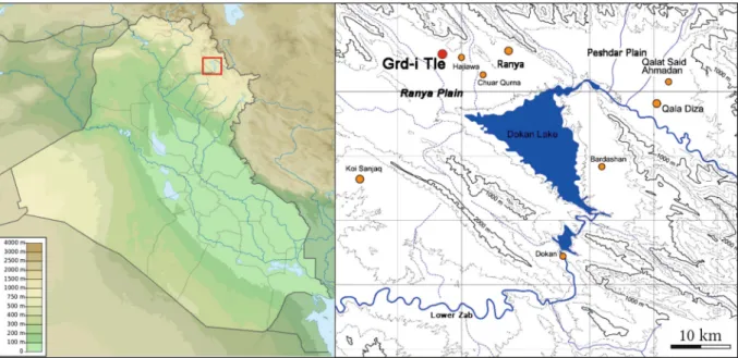
The Hungarian Archaeological Mission of Eötvös Loránd University, Budapest to Kurdistan (Iraq) lead by Tamás Dezső and Gábor Kalla has set out several goals for the first season (09.09.2016 – 07.09.2016) of the excavations at thetell-settlement of Grd-i Tle (Ranya Plain)(Fig. 1–2).1 One of our original goals was the investigation of an administrative centre lying at the eastern frontier of the Neo-Assyrian Empire, and for that, the site of Grd-i Tle seemed to be an appropriate place.2 This region was the starting point of the Assyrians campaigns towards Western Iran, led through the Zagros range.
The strategic significance of the settlement is obvious,3with its remarkable size it dominates the landscape of the western part of the Ranya Plain and, as for the matter of size, only one site can be compared to it, Tell Basmusian,4which is by now submerged in the Dokan Lake and can only be investigated provisionally, during low tide, with great difficulty.
One of the main goals of the first season of the excavations of Grd-i Tle was to define what kind of methods are at our disposal to reach the Neo-Assyrian layers and to reveal how deep these layers are lying beneath the features of later periods.
Due to the complete lack of any previous excavation of the site, the most important goal was to carry out a detailed topographic survey and thorough stratigraphical analysis of the available
1 The members of the expedition were: Tamás Dezső (Eötvös Loránd University, Budapest), Gábor Kalla (Eötvös Loránd University, Budapest), Barzan Baiz Ismail (Raparin Directorate of Antiquities and Heritage), Kamal Rasheed (Sulaimaniya Directorate of Antiquities and Heritage), Maxim Mordovin (Eötvös Loránd University, Budapest), Zsófia Masek (Hungarian Academy of Sciences, Budapest), Ardalan Khwsnaw (Eötvös Loránd University, Budapest), Nóra Szabó (Eötvös Loránd University, Budapest), Aram Ali Hama Amin (Eötvös Loránd University, Budapest), Attila Weisz (Geodata, Salisbury Ltd.), Lajos Sándor.
2 Our investigations fit well to the range of the recently enhanced archaeological excavations in Kurdistan (Iraq).
On the latter projects see Kopanias – MacGinnis – Ur 2015.
3 On the significance of the site see previously Hasegawa – Yamada 2016.
4 al-Soof 1970.
234
Grd-i Tle 2016
strata. The latter is a part of the planned five-year typochronological evaluation of the pottery assemblages of the site preliminary known to be occupied from the 7thmillennium BC. until the early or mid-19thcentury AD.5
Fig. 1.Location of the site in Iraq (after Hasegawa – Yamada 2016, Fig. 2).
Fig. 2.Aerial view of the site.
In the first two weeks of the research the site and its closest accessible vicinities have been digitally and topographically measured giving as a result a detailed topographic map(Fig. 3–4). The survey
5 See Hasegawa – Yamada 2016.
235
Tamás Dezső et al.
was supplemented by multi-layered field-walking including the use of metal detector fixing the coordinates of all finds.
After the survey three main locations have been set on the site. The first is situated on the very top of thetell, cutting through its north-eastern edge (Field 01). The second, smaller location occupies a section of the south-eastern plateau (Field 02), while for the third one was chosen a recently ploughed surface on the lower plateau of the southern slope of the site, where a higher concentration of the finds could have been observed during preliminary survey (Field 03).
Fig. 3.Isometric map of the site with the locations of the excavated fields.
Fig. 4.3D model/picture of the site as viewed from the South.
236
Grd-i Tle 2016
Non-destructive research of the site
Among the non-destructive methods of the research the topographic survey should be men- tioned at the first place. Carried out by Attila Weisz (Salisbury Ltd.) using Leica Total Station TCRA 1101 this survey consists of dataset of more than two thousand heights creating thus a trustful and high-density 3D view of thetell and its neighbourhood.6 The whole site was covered by a 10 × 10 m net giving a stable grid for aligning archaeological trenches. The height of the control point No. 1 is 602.32 m above sea level. According to the survey, the top of thetell is situated 26–28 m above the surrounding plain, its main dimensions 76 × 86 m. This highest plateau is encircled by a lower, approximately circular rampart, remains of which have been used in the modern time for irrigation. This may be identified with the traces of an antique city wall, the exact date and features of which are to be defined during the following season.
The dimensions of the lower “city” are 250 × 210 m.
The topographic survey was done simultaneously with the field walking and metal detecting.
Lajos Sándor is the professional metal detectorist who has been thoroughly surveying the site and three excavation trenches. Results of his work greatly ease to define the main timeframes of the site and the pattern of the inhabitation in particular chronological phases. GPS coordinates of the each removed find have been fixed and the finds also have been photodocumentedin situ. Only the finds from the surface or from the ploughed upper layer have been collected – either metal or ceramic – the undamaged archaeological context always was kept intact even in case of deeper signals. As a result, the field walking has produced significantly more metal objects (jewellery and coins) and thus information clearly showing an intensive 17th–18th century settlement strata south of the tell. Among several noteworthy finds two late 17th-century Nurembergian tokens must be mentioned.
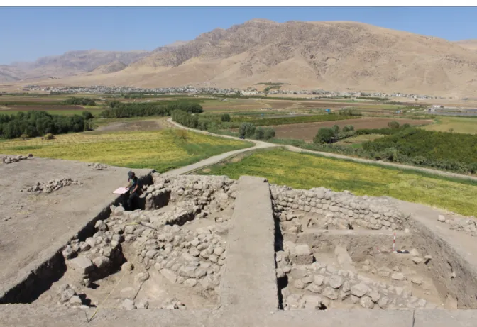
Field 01, Squares 790-530/790-540
The first trench(Fig. 5)situated on the edge of the upper plateau of the site had as a goal to create a stratigraphical sequence of the ceramic from the latest phases of the inhabitation. Works here were led by Tamás Dezső and Maxim Mordovin. The most important discovery at this location was the appearance of a mortar stone rampart wall, in average 0.8 m thick having at least three building phases. The dating of the construction of the wall is not yet definable but according to the documented stratigraphy this wall strongly defined the latest building activity of the spot. At least eleven other wall-fragments have been detected, all of them aligning to the mortar wall. In any case, the excavated wall is part of a fortification. The military character of the structure is emphasised by a semi-circular tower excavated in the east-northern part of the trench.
During this first season in average a depth of 1–1.4 m has been reached at the first location.
The observations confirms existence of at least three main and three less significant habitation strata all datable to the so-called “late Islamic” period. The finds of lead bullets and – most of all – particular types of pipes enables to define this period to the 18th and early 19th century.
The presence of the bullets at the same time unambiguously refers to somewhat conflict in that time explainable later in context of local history.
6 Although formerly a Japanese team carried out preliminary topographical surveys (Hasegawa – Yamada 2016) our future work necessitated the accomplishment of our own survey.
237
Tamás Dezső et al.
Fig. 5.View of the Field 01 from the west showing the excavated “late Islamic” walls.
The excavated location in the Trench I seems to have been a domestic part of the latest fortification complex. This is confirmed by the large number of bread-baking ovens (locally tendur) observed on every settlement strata. One of the ovens is especially interesting because of its inner geometric decoration. This fact is very unique in itself and unusual having no known analogies so far across Middle East. It might have been connected with some kind of hidden custom or tradition which was kept in secret.
The strata on the outer side (north) of the wall can be separated into three main phases. The upper layers unambiguously belong to the same “late-Islamic” occupation that have been observed within the walls and consisted mainly of the levelling and waste layers. The second – unfortunately precisely not datable yet – phase shows very characteristic signs of destruction by fire preceded the Islamic settlement. According to the latest finds from these layers it can be connected to the Hellenistic (or Parthian?) period. The first one can be confirmed by a Greek coin from a lower layer. At the same time some unearthed bronze and iron arrowheads refer to a military conflict as a cause for the destruction. The third phase is presented by a single layer so far. This very hard, rammed earth with relatively small amount of finds can be interpreted as foundation or wall and thus presenting an even earlier stage of the fortification of thetell.
Evaluating the latest phases of the settlement, more exactly the reusing of the earlier fortifica- tions during the 18th–19thcenturies it can be clearly stated that the inhabitants can be identified with the local Kurdish population. Even the possibility of the Kurdish origin of the mortar walls cannot be excluded but this can be clarified via further excavations.
238
Grd-i Tle 2016
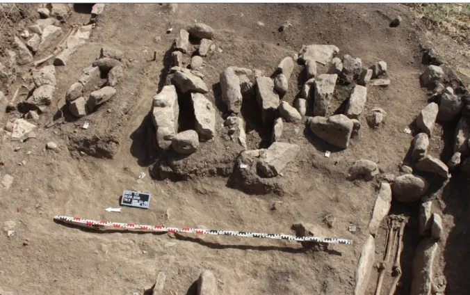
Fig. 6.Burials excavated in Field 02.
Field 02, Square 850-480
The second location led by Gábor Kalla is situated on the eastern plateau of thetellrising up to 12 m above the plain surrounding the site. The spot with dimensions 4 × 4 m was opened to verify the presence of phases preceded the “Islamic period”. Almost immediately under the surface a number of closely located cist graves (in stone-built coffins) have been discovered(Fig. 6).
Fig. 7. Hellenistic silver tetradrachm from beside Grave 7.
Among the altogether 22 burials only four were adults, the rest belonged to new-borns and infants.
Most of the cist graves were constructed very similarly: the inner walls of the grave pit were coated by larger stone slabs, the deceased was laying on his back orientating west–east, with heads turned south. The cists then were covered by other stone slabs. None of the burials has contained any grave goods. Their fillings contained pottery from the surrounding soil including large number of ceramics of medieval character but seemingly much earlier than the pottery from the “late-Islamic” layers of Field 01. Beneath the excavated graves a dry stone wall and fragments of rammed earth wall could have been documented.
Both of them can be dated to the Hellenistic or Parthian period, which dating is confirmed by a Macedonian coin minted between 310 and 301 BC. in Lampsacus(Fig. 7).
239
Tamás Dezső et al.
Field 03, Square 820-400/830-400
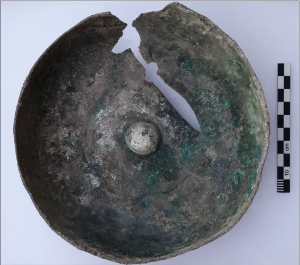
Field 03 situated on the lowest plateau within the visible stone fortifications was set off on a site of larger concentration of pottery and an oven destroyed by a recent agricultural activity. At the same time the metal detecting activity gave a strong and clear signal on the spot. Therefore it was decided to testify the location in order to clarify the stratigraphical situation of the lowest part of the site. The extent of the destruction, however, decreased the possibility of the proper research therefore the works here were stopped after the documentation of the excavated oven and its closest neighbourhood. In the middle of the oven a larger bronze vessel was found – this gave the clear metal sound during the research(Fig. 8). The dating of the documented features and the bowl – according to the coins from the same layer – can be narrowed to the 18th—19th centuries.
Fig. 8.Bronze bowl from Field 03.
References
al-Soof, B. 1970: Mounds in the Rania Plain and excavations at Tell Bazmusian (1956).Sumer26, 65–104.
Hasegawa, A. – Yamada, Sh. – Ismail, B. B. 2016: Archaeological Investigations at Grd-i Tle in the Ranya Plain, Iraqi Kurdistan. Al-R ¯afid ¯an37, 143–152.
Kopanias, K. – MacGinnis, J. – Ur, J. (eds.) 2015:Archaeological projects in the Kurdistan region in Iraq.
The Directorate of Antiquities of Kurdistan, Erbil.
240