Ser. 3. No. 6. 2018 |
ex Instituto Archaeologico Universitatis de Rolando Eötvös nominatae
DISSERT A TIONES ARCHAEOLO GICAE
Arch Diss 2018 3.6
D IS S E R T A T IO N E S A R C H A E O L O G IC A E
Dissertationes Archaeologicae
ex Instituto Archaeologico
Universitatis de Rolando Eötvös nominatae Ser. 3. No. 6.
Budapest 2018
Dissertationes Archaeologicae ex Instituto Archaeologico Universitatis de Rolando Eötvös nominatae
Ser. 3. No. 6.
Editor-in-chief:
Dávid Bartus Editorial board:
László BartosieWicz László Borhy Zoltán Czajlik
István Feld Gábor Kalla
Pál Raczky Miklós Szabó Tivadar Vida
Technical editor:
Gábor Váczi Proofreading:
ZsóFia KondÉ Szilvia Bartus-Szöllősi
Aviable online at htt p://dissarch.elte.hu Contact: dissarch@btk.elte.hu
© Eötvös Loránd University, Institute of Archaeological Sciences Layout and cover design: Gábor Váczi
Budapest 2018
Contents
Zsolt Mester 9
In memoriam Jacques Tixier (1925–2018)
Articles
Katalin Sebők 13
On the possibilities of interpreting Neolithic pottery – Az újkőkori kerámia értelmezési lehetőségeiről
András Füzesi – Pál Raczky 43
Öcsöd-Kováshalom. Potscape of a Late Neolithic site in the Tisza region
Katalin Sebők – Norbert Faragó 147
Theory into practice: basic connections and stylistic affiliations of the Late Neolithic settlement at Pusztataskony-Ledence 1
Eszter Solnay 179
Early Copper Age Graves from Polgár-Nagy-Kasziba
László Gucsi – Nóra Szabó 217
Examination and possible interpretations of a Middle Bronze Age structured deposition
Kristóf Fülöp 287
Why is it so rare and random to find pyre sites? Two cremation experiments to understand the characteristics of pyre sites and their investigational possibilities
Gábor János Tarbay 313
“Looted Warriors” from Eastern Europe
Péter Mogyorós 361
Pre-Scythian burial in Tiszakürt
Szilvia Joháczi 371
A New Method in the Attribution? Attempts of the Employment of Geometric Morphometrics in the Attribution of Late Archaic Attic Lekythoi
Anita Benes 419 The Roman aqueduct of Brigetio
Lajos Juhász 441
A republican plated denarius from Aquincum
Barbara Hajdu 445
Terra sigillata from the territory of the civil town of Brigetio
Krisztina Hoppál – István Vida – Shinatria Adhityatama – Lu Yahui 461
‘All that glitters is not Roman’. Roman coins discovered in East Java, Indonesia.
A study on new data with an overview on other coins discovered beyond India
Field Reports
Zsolt Mester – Ferenc Cserpák – Norbert Faragó 493
Preliminary report on the excavation at Andornaktálya-Marinka in 2018
Kristóf Fülöp – Denisa M. Lönhardt – Nóra Szabó – Gábor Váczi 499 Preliminary report on the excavation of the site Tiszakürt-Zsilke-tanya
Bence Simon – Szilvia Joháczi – Zita Kis 515
Short report on a rescue excavation of a prehistoric and Árpádian Age site near Tura (Pest County, Hungary)
Zoltán Czajlik – Katalin Novinszki-Groma – László Rupnik – András Bödőcs – et al. 527 Archaeological investigations on the Süttő plateau in 2018
Dávid Bartus – László Borhy – Szilvia Joháczi – Emese Számadó 541 Short report on the excavations in the legionary fortress of Brigetio (2017–2018)
Bence Simon – Szilvia Joháczi 549
Short report on the rescue excavations in the Roman Age Barbaricum near Abony (Pest County, Hungary)
Szabolcs Balázs Nagy 557
Recent excavations at the medieval castle of Bánd
Thesis Abstracts
Rita Jeney 573
Lost Collection from a Lost River: Interpreting Sir Aurel Stein’s “Sarasvatī Tour”
in the History of South Asian Archaeology
István Vida 591
The Chronology of the Marcomannic-Sarmatian wars. The Danubian wars of Marcus Aurelius in the light of numismatics
Zsófia Masek 597
Settlement History of the Middle Tisza Region in the 4th–6th centuries AD.
According to the Evaluation of the Material from Rákóczifalva-Bagi-földek 5–8–8A sites
Alpár Dobos 621
Transformations of the human communities in the eastern part of the Carpathian Basin between the middle of the 5th and 7th century. Row-grave cemeteries in Transylvania, Partium and Banat
DissArch Ser. 3. No. 6. (2018) 527–539. DOI: 10.17204/dissarch.2018.527
Archaeological investigations on the Süttő plateau in 2018
Zoltán Czajlik Katalin Novinszki-Groma
Institute of Archaeological Sciences Institute of Archaeological Sciences
Eötvös Loránd University Eötvös Loránd University
czajlik.zoltan@btk.elte.hu groma.kata@gmail.com
László Rupnik András Bödőcs
MTA-ELTE Research Group Institute of Archaeological Sciences
for Interdisciplinary Archaeology Eötvös Loránd University
rupnik.laszlo@btk.elte.hu bodocs.andras@btk.elte.hu
Eszter Fejér András Jáky
Institute of Archaeological Sciences Institute of Archaeological Sciences
Eötvös Loránd University Eötvös Loránd University
feszter18@gmail.com jakyandras@gmail.com
Sándor Puszta Zsófia Sörös
Institute of Archaeological Sciences Archaeological Heritage Protection Directorate
Eötvös Loránd University Hungarian National Museum
fractal@fractal.hu soros.zsofia@mnm.hu
Bíborka Vass Szabolcs Czifra
Archaeological Heritage Protection Directorate Archaeological Heritage Protection Directorate
Hungarian National Museum Hungarian National Museum
vass.biborka@mnm.hu czifra.szabolcs@hnm.hu
Abstract
The Early Iron Age site complex of Süttő is located on a loess plateau on the right bank of the Danube.
After a long history of research of the Early Iron Age fortified settlement, tumulus groups and flat cemetery, between 2013–2017, some pioneer investigations were carried out using non-invasive methods. In 2018, members of the Institute of Archaeological Sciences of the Eötvös Loránd University and the Archaeological Heritage Protection Directorate of the Hungarian National Museum conducted an interdisciplinary research project (archaeological excavation, geophysical measurements, metal detecting survey, systematic field walking, geological drilling) on the plateau in the framework of the Interreg DTP Iron Age Danube project.
As a result of intensive research, it became clear that aside from the Early Iron Age necropolis, the eastern part of the plateau was used as a burial site in the Early Bronze Age, as a settlement in the Late Bronze Age, and we must consider the existence of a Late Iron Age settlement in this area as well.
528
Zoltán Czajlik – Katalin Novinszki-Groma – László Rupnik et al.
Geographical background
The Early Iron Age settlement complex (Süttő-Nagysánctető, Nagysánc), and cemeteries (Sánci- dűlő, Sáncföldek) were established on the top of the loess plateau next to the Danube. As detailed in our previous publication, there were two settlements on the loess plateau cut up by gullies, sloping into the Danube (the fall is approx. 40 m), and the necropolises were further south. The part of the plateau near the Danube was split into blocks separated by deep gullies due to the karstification of the loess, making them a naturally protected place for settlement.
The series of loess plateaus, which can be followed from Dunaalmás to Tát, is bordered by hills from the south, and its Neszmély–Süttő section by the Gerecse mountain range, which is more than 600 m high.1 While the right bank of the Danube is characterized by a bluff and hills, the left bank of the river (which belongs to Slovakia) is an almost flat, alluvial plane with traces of former river beds in the section between Virt (Vért) and Kravany nad Dunajom (Karva). Several major islands (e.g. Mocsi Island)
are located in this part of the Danube. These topo- graphical conditions made possible the formation of a unique micro-region, which was culturally connected to the territories north of the Danube in prehistoric times.
Results of previous topographical research
The first topographic research of the Süttő site (identified in the 1930s2) was carried out be- tween 1968 and 1971 by István Horváth and István Torma in the works of the Archaeological Topography of Hungary. In addition to the identification of some of the tumuli, on the basis of the two previously known hillforts, an Early Iron Age site complex similar to Százhalombatta was documented.3 The research programs of Éva Vadász and Gábor Vékony between 1978 and 1990 included both the Nagysánctető settlement and the burial mounds, as well as the flat cemetery found in the meantime,4 however, their results could not be processed and evaluated before they deceased. The archaeological evaluation of their research is currently carried out by Katalin Novinszki-Groma, in her PhD-dissertation.5
In addition to the Early Iron Age site complex, archaeological remains of several other periods are also known on the Süttő plateau and in the narrow Danube bank below. Based on István Horváth’s and István Torma’s topographic research, and the excavations of Gábor Vékony, we have to reckon with the settlements of the Neolithic Age, Early Bronze Age(?), Middle Bronze Age and Late Bronze Age on the Nagysánctető prior to the Early Iron Age fortified settlement.
István Horváth and István Torma observed the settlement remains of the Early Bronze Age Hatvan culture on a loess block called Kissánc, located east of the hilltop settlement.
The area called Nagysánc (MRT5, site 20/6) west of Nagysánctető is also known as an Early Iron Age settlement, where there were Late Bronze Age and Celtic settlements based on sur-
1 Czajlik et al. 2015, 62–66, Fig. 4.
2 Tompa 1934–35, 104; Mérey Kádár 1958.
3 Horváth et al. 1979, 311–313.
4 Vadász 1983, Vadász 1986
5 Preliminary reports: Novinszki-Groma 2017a; Novinszki-Groma 2017b.
529 Archaeological investigations on the Süttő plateau in 2018
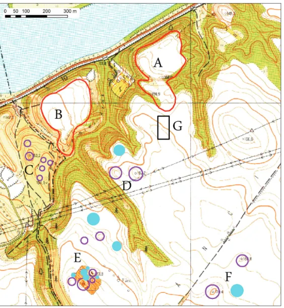
face finds as well.6 This is confirmed by the publication of Márta H. Kelemen, who dated a characteristic ceramic bodysherd from here to the LTB–C1 period.7 Additionally, she assumed a contemporaneous cemetery near the Nagysánc settlement on the basis of the typical finds in Ilona Hunyady’s monograph.8 At the site of Süttő-Sáncföldek, during the excavation of the Early Iron Age cemetery, Celtic settlement features (pits?) were also identified by Éva Vadász and Gábor Vékony (Fig. 1).
In the Hosszú-valley between the Kissánc and Nagysánctető at the bank of the Danube, Erzsébet Patek and Amália Mozsolics excavated a part of a Middle Bronze Age (Magyarád cul- ture, Transdanubian Encrusted Pottery Culture) settlement. Roman ceramic fragments were also reported from the same place.9 Moreover, under the bridge of the high road along the Dan- ube, two Roman milestones were found in the section between Nagysánctető and Nagysánc,10 suggesting that the limes road could follow the same trail as the modern road today.
6 Horváth et al. 1979, 311–312.
7 H. Kelemen 1987, 193–194, Pl. XI. 6.
8 H. Kelemen 1987, 193, Pl. XI. 3.
9 Horváth et al. 1979, site 20/15, 315–317.
10 Rómer 1866, 161, 182.
Fig. 1. The results of previous topographic research on the Süttő plateau (Czajlik et al. 2015, Fig. 7.).
530
Zoltán Czajlik – Katalin Novinszki-Groma – László Rupnik et al.
Lessons learned from the study of archive aerial photographs and maps of the Süttő plateau
As part of the present research, we began collecting and studying relevant archive maps and aerial photographs about the Süttő micro-region. The first results are summarized below.
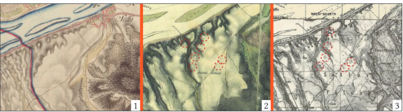
Traces of neither the fortified settlements nor the tumuli (that must have been taller then) were depicted on the map of the First Military Survey (1782–1785). This situation has changed in the case of the Second (1819–1869) and Third Military Surveys (1872–1884). On these two map sources, essentially the same phenomena were delineated from Süttő (Fig. 2): the tumuli that can still be well identified on the surface today, except for the tumulus group “C”,11 which is located in a bushy, wooded area and which is not included in any survey. On this basis, two conclusions can be drawn. On the one hand, in the area that is cultivated continuously, we probably cannot count on the destruction of many large mounds in the last 250 years. On the other hand, for understandable reasons, no observations were made during the mapping work in the forested areas.
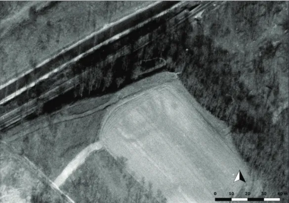
As far as we know, the earliest archive aerial photographs are from 1940, when the entire course of the river Danube was recorded throughout the country. Due to the conditions of the vegetation during the shooting, only traces of already known tumuli can be observed at Süttő.12 In connection with his research of the Ripa Pannonica, Zsolt Visy also examined the archive footage of this limes section.13 He identified the double trenches of the Azaum 5 Roman Age watchtower and traces of Iron Age tumuli thanks to an aerial photograph from 1954.14 Recently, the number of available recordings has increased significantly through the webpage fentrol.hu. These images can be used for archaeological research in many cases, also in the case of Süttő. Thanks to the fortunate timing, positive crop signs of the trench of a previously unknown watchtower can be observed east of the Iron Age site on a photograph from 1975 (Fig. 3). However, full certainty requires field research. Besides that, we could iden- tify additional linear phenomena (ditches, former road) as well, the exact age of which is also questionable. An excellent example of the “in the right place and at the right time” axiom of
11 Czajlik et al. 2015, Fig. 7.
12 The images are found in the collection of the Military History Institute and Museum, Budapest (Inv. Nr:
HI 69398–69399).
13 Visy 2003, 41–42, Figs 62–64.
14 Visy 1990, 24; Visy 2003, 41, Fig. 62. (HI 23119). For the watchtower belonging to Neszmély by administra- tion, see also: Visy 2011, 65, Fig. 51.
1 2 3
Fig. 2. The representation of the Süttő plateau in the First (1), Second (2) and Third (3) Military Survey (analysis by László Rupnik).
531 Archaeological investigations on the Süttő plateau in 2018
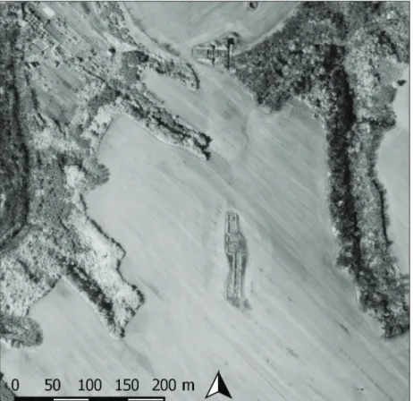
aerial photography is the 1987 series of images showing the open excavation trenches by Gábor Vékony and Éva Vadász (Fig. 4). The importance of this information is increased by the fact that a complete map of the excavation has not been retained, so its location can be recon- structed by fitting the aerial photographs. Using a photogrammetric process, with a sufficient number of photographs, a digital surface model (DSM) can also be made (Fig. 5). In the same series of photos from 1975, the Odiavum 5 Roman Age burgus is also visible (not covered by trees and bushes, Fig. 6).
Modern aerial archaeological photography at the Süttő site-complex
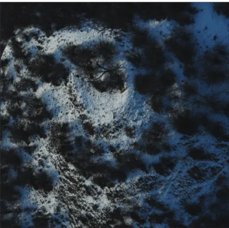
The aerial archaeological research of the Iron Age site complex began in 2008,15 and by the end of 2018 we carried out archaeological observations 12 times with Cessna aircrafts and Robinson helicopters. Of the spring/summer investigations, the most successful flights were June 6, 2013 and June 22, 2016. In 2013 it was possible to identify the circular ditch of the largest member of the tumulus group “D” in autumn-sown wheat, and the same plant made it possible to get to know the northern tumulus groups in detail in 2016. In 2016, the location of the 1983–1990 excavations, which were previously known from incomplete overview maps (and from the above mentioned synchronous aerial photos from 1987) could also be identified.
Of the winter aerial surveys, it is worth mentioning the one on February 28, 2018, when the tumulus group “C”, located in a separate loess block, was first documented. At the edge of the plateau north of the tumuli, overlooking the Danube, the remains of the Odiavum 5 Roman Age watchtower – in the bushes – were also photographed (Fig. 7).
15 Czajlik et al. 2015, 64.
Fig. 3. Trenches of a previously unidentified Roman Age watchtower(?) south of the Süttő-Kissánc site on an aerial photograph (March 1, 1975, fentrol.hu, László Rupnik).
532
Zoltán Czajlik – Katalin Novinszki-Groma – László Rupnik et al.
Fig. 4. The excavation trenches of Éva Vadász and Gábor Vékony on an archive aerial photograph (May 10, 1987, fentrol.hu, László Rupnik).
Fig. 5. A surface model based on archive aerial photographs of the Süttő plateau (March 1, 1975, fen- trol.hu, László Rupnik).
533 Archaeological investigations on the Süttő plateau in 2018
Fig. 6. The remains of a Roman Age watchtower northeast of Süttő-Nagysánc on an archive aerial photograph (March 1, 1975, fentrol.hu, László Rupnik).
Fig. 7. The remains of a Roman Age watchtower northeast of Süttő-Nagysánc (Zoltán Czajlik, February 28, 2018).
534
Zoltán Czajlik – Katalin Novinszki-Groma – László Rupnik et al.
Geophysical mapping, drone aerial photography, field surveys
Our field topographic research conducted on the Süttő plateau 2014–2017 was briefly re- ported last year.16 In addition to the regular aerial archaeological prospection, we conducted geophysical magnetometer surveys and minor field surveys in 2014. Magnetic research af- fected a small part (about 1 ha) of the tumulus group “E”, and besides the encircling ditches of the tumuli still identifiable on the surface, a trace of a smaller, circular ditch of approx.
20 m diameter was also mapped.17 In cooperation with the Institute of Archaeology of the Hungarian Academy of Sciences, we carried out Overhauser and fluxgate magnetometer comparative measurements in 2016. During the magnetic mapping, the circular ditches of the known mounds of the tumulus group “D” were identified, as well as a smaller circular ditch of approx. 20 m diameter that was non-observable on the surface. A relief model of this zone was also made on the basis of drone aerial photographs with surface measuring points. In the course of the simultaneously conducted large-scale field surveys and drone aerial photography, traces of a previously unknown Early Iron Age settlement west of the southern tumulus group (“F”) were observed. In the framework of the Iron Age Danube pro- ject, geophysical surveys were carried out in 2017 (2–2 days in the spring and the autumn) on the southernmost part of the site complex, south of the dirt road connecting Süttő and Dunaszentmiklós. The resulting magnetic anomaly map shows a remarkably clear geolog- ical background. The encircling ditches of the larger, well-known tumuli, as well as two additional, smaller (each one is approx. 20 m in diameter) circular ditches were observed, similarly to the situation of tumulus group “E” in 2014 and tumulus group “D” in 2016.18 In December 2017, field surveys were carried out to document the boundaries of the Early Iron Age settlement identified west of the southern tumuli group in July 2016. During the exam- ination of the surrounding areas we identified a grave that could be dated to the transition of the Late Bronze Age/Early Iron Age period (Fig. 8).
Field research in 2018
The main goal of the geophysical research carried out in July and August 2018 was to sur- vey the site of Süttő-Sáncföldek in accordance with the current cultivation status of the area and the aims of the planned excavation in September 2018. The surveyed area included the area of the Early Iron Age flat cemetery, excavated by Gábor Vékony and Éva Vadász in 1983–1990, as well as the Late Iron Age site presumed on the basis of previous topographic and excavation data.
Intensive field research took place between September 6 and October 10, 2018, in cooper- ation with the Department of Archaeometry, Archaeological Heritage and Methodology of the Institute of Archaeological Sciences, Eötvös Loránd University and the Hungarian National Museum.19
16 Czajlik et al. 2017, 350–353.
17 Czajlik et al. 2015, Fig. 8.
18 For the results of the geophysical surveys in 2017, see Czajlik et al. 2017.
19 MRT 5, site 20/7, here named Süttő-Sánci dűlő II, site ID: 2601. The works were implemented and funded by the Danube Transnational Programme, Monumentalized Early Iron Age Landscapes in the Danube river basin (Iron-Age-Danube, DTP1-1-248-2.2).
535 Archaeological investigations on the Süttő plateau in 2018
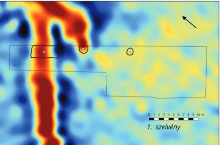
In the first five days of the research, we continued the archaeological geophysical measure- ments started in August with the following devices: two GSM19W Overhauser magnetom- eters and a Trimble Geo 7 GPS. They were arranged and used identically all year round. The measurement of the temporal change of the magnetic field was solved by local base measure- ments, and the rover unit proceeded in variometer layout; the distance between the lines was 0.75 m and the distance within the line was 0.5 m. The GPS data were corrected on the basis of base stations (Fig. 9).
In parallel with the geophysical measurements, a systematic field walking survey was also conducted, which was complemented by Lajos Sándor’s metal detecting research. Finds from the surface collection were cleaned on the base and then sorted by age together with the ob- jects from metal detecting (Fig. 10). The location of the excavation Trench 1 was designated based on the geospatial processing of the results compared to the map of the geophysical measurements, northwest of the previous excavations at a distance of 100–120 m.
Fig. 8. The ceramic remains of a Late Bronze Age(?) grave at Süttő-Sáncföldek Sherds from the dis- turbed grave found during field survey (December 13. 2017.). 1 – rim of a large pot with handle and graphite painting on the surface, 2 – upper part of a larger bowl with handle and painted graphite stripe on the internal surface, 3 – profiled shoulder with sidelong cannelure, 4 – sherd with vertical cannelure and graphite painting on the external surface, 5 – sherd with graphite painted X-motives on the internal surface (Katalin Novinszki-Groma).
1
2 3
4 5
536
Zoltán Czajlik – Katalin Novinszki-Groma – László Rupnik et al.
Trench 1 was opened on a 5×20 meter surface. At a depth of 20–30 cm, ceramic fragments were observed at locations predetermined by the map of the geophysical measurements, so we stopped machine earthwork on this level. At the same time, we extended the trench to the southwest with a 5×10 meter surface. Ceramic sherds appeared on the surface in this area of the “L”-shaped trench as well (Fig. 11).
After cleaning, most of the ceramic fragments collected on the surface turned out not to be related to any archaeological phenomenon; their context was probably destroyed by earlier ag- ricultural works. In the northern part of our Trench 1 we discovered a short section of a ditch, possibly a loess hollow way, in which we could separate several layers of filling. Based on the map of magnetometer geophysical surveys, the end of a projection, branch of this phenomenon fell into Trench 1 as well. At the bottom
of that, several large, near intact vessels, organic material residues, and frag- ments of 2–3 iron objects lying close to each other were discovered (Fig. 12).
Only one of the groups of ceram- ic fragments observed in Trench 1 proved to be a grave. Since this phe- nomenon was selected in cooperation with Mária Hajnalová, specialist of the Constantine the Philosopher Univer- sity, Nitra for archaeobotanical sam- pling, its excavation was performed in a 50×50 cm grid system and a soil sample of each unit was taken every 5 cm. Based on the ceramic material from the phenomenon, the grave can be dated to the Early Bronze Age.
Fig. 9. Süttő-Sáncföldek, 2018. Geophysical mapping of the northern part of the site (Sándor Puszta – Zoltán Czajlik).
Fig. 10. Variations of Early Iron Age bronze Navicella (1–3) and Bow (4) fibulae from the metal detector survey of the Süttő plateau (September, October, 2018) Katalin Novinszki-Groma – Eszter Fejér).
537 Archaeological investigations on the Süttő plateau in 2018
On September 19, we opened Excavation Trench 2 southwest of Trench 1. This surface was also “L”-shaped, a 5-meter-wide section is attached to the west of the 5×25 meter trench. In Trench 2, we could mark several dark patches at a depth of 20–30 cm, in which fragments of burnt daub, ceramic sherds and bones could be observed. These were proven to be archaeo- logical phenomena later.
In the northern part of Trench 2, we found a pit with grinding stones, probably Celtic on the basis of the accompanying ceramic material. These finds were laid over a charcoal layer. South of that, two oval pits were found, which contained large amounts of animal bones, ceramics and several metal finds. Based on a bronze dagger and ceramic material discovered here, the ensembles were dated to the middle of the Late Bronze Age. In the southern part of Trench 2, moving from east to west, there was a shallow feature probably dated to the Late Iron Age, a pit containing a whetstone and the remains of a building dating back to the Celtic period. The latter feature contained only a few finds and a child’s skull laid on its bottom.
Fig. 11. The contours of the phenomena discovered in Trench 1 visualized on the map of the mag- netometer survey (András Bödőcs – Sándor Puszta).
Fig. 12. Intact vessel on the bottom of ditch feature 32 (3D model, András Bödőcs).
538
Zoltán Czajlik – Katalin Novinszki-Groma – László Rupnik et al.
Parallel to the excavation work, Lajos Sándor continuously monitored the excavated spoil heap, and combed through an approx. 5 ha area in the vicinity of the excavation with metal detector. During the same period, Balázs Nagy and the students of the Department of Physical Geography of the Eötvös Loránd University collected core samples from a number of archae- ological phenomena observed in geophysical surveys (e.g. circular ditches of tumuli), in order to determine their depth and shape.
The excavation was completed on October 10, 2018, with the back-filling of the two trenches.
Summary
Based on the results of previous archaeological works and modern landscape archaeological research started seven years ago on the Süttő plateau, we carried out intensive archaeolog- ical investigations, combining aerial, geophysical and metal detecting surveys, systematic field walking and excavations in 2018. Among the results of the aerial archaeological re- search, the examinations of watchtowers, especially the possibly Roman Age watchtower at the Süttő-Kissánc site (which has been newly identified on archive photographs) and the photogrammetric relief model of the whole site complex, should be highlighted. One of the most important lessons learned from the excavations of the NW zone of the Süttő plateau, which has been intensively researched with all the methods listed above, is that there are remains of more archaeological periods than has previously been known. An important nov- elty is the Early Bronze Age grave excavated with detailed sampling and the Late Bronze Age settlement features, while there is clear evidence of a Celtic settlement at the same place.
Regarding the Late Bronze Age and Celtic settlements, it should be noted that traces of con- temporary burials are likely to be identified on the Süttő plateau as well.
Participants of the field-campaign in 2018: Zoltán Czajlik (field director, archaeologist), András Bödőcs and László Rupnik (GIS experts, archaeologists), Mária Hajnalová (archaeo- botany expert, archaeologist), Balázs Nagy (geomorphologist), Szabolcs Czifra, Nejc Dolinar, Eszter Fejér, András Jáky, Katalin Novinszki-Groma, Zsófia Sörös, Bíborka Vass, (archaeolo- gists), Marcell Barcsi, Rebeka Gergácz, Dalma Kerekes, Flóra Klinga, Gizella Kovács, Ágota Madai, Péter Mogyorós, Artúr Nyírő, Bertalan Pillik, Bence Soós and Lili Sólyom (students of the Eötvös Loránd University).
References
Czajlik, Z. – Novinszki-Groma, K. – Horváth, A. 2015: Données relatives à la topographie de la microrégion de Süttő au Premier âge du Fer. In: Borhy, L. – Dévai, K. – Tankó, K. (eds.): Studia archaeologica Nicolae Szabó LXXV annos nato dedicata. Budapest, 59–74.
Czajlik, Z. – Puszta, S. – Kovačević, S. – Tiefengraber, G. – Tiefengraber, S. – Bödőcs, A. – Rupnik, L. – Novinszki-Groma, K. – Jáky, A. – Holl, B. 2017: Report on magnetometer geophysical surveys conducted in Hungary, Austria and Croatia in the framework of the Interreg Iron Age Danube project. Dissertationes Archaeologicae 3/5, 343–360.
Horváth, I. – H. Kelemen, M. – Torma, I. 1979: Magyarország Régészeti Topográfiája 5. Komárom megye régészeti topográfiája. Esztergom és a dorogi járás (Archäologische Topographie Ungarns.
Archäologischen Topographie des Komitat Komárom. Esztergom und die Kreis Dorog). Budapest.
H. Kelemen, M. 1987: Komárom County I. In: Kovács, T. – F. Petres, É. – Szabó, M. (eds.): Corpus of Celtic Finds in Hungary 1. Transdanubia I. Budapest, 179–230.
539 Archaeological investigations on the Süttő plateau in 2018
Mérey Kádár, E. 1958: Die früheisenzeitlichen Hügelgräber von Süttő (1948). Dissertationes Archaeo- logicae 1/1, 86–88.
Novinszki-Groma, K. 2017a: New data on the Burial Customs in the Early Iron Age on the basis of Examples from Northeast-Transdanubia. In: Beljak Pažinová, N. – Borzová, Z. (eds.): Sedem- decénií Petra Romsauera. Studia Historica Nitriensia – Supplementum. Nitra, 155–171.
Novinszki-Groma, K. 2017b: Inhumation graves at the Early Iron Age cemetery of Süttő. In: Myroš- šajová, E. – Pare, C. – Stegmann-Rajtár, S. (eds.): Das nördliche Karpathenbecken in der Hall- stattzeit. Wirtschaft, Handel und Kommunikation in früheisenzeitlichen Gesellschaften zwischen Ostalpen und Westpannonien. Budapest, 471–497.
Rómer, F. 1866: Műrégészeti kalauz [Archaeological guide]. Budapest.
Tompa, F. 1934–35: 25 Jahre Urgeschichtsforschung in Ungarn 1912–1936. Bericht der Römisch-Germa- nischen Komission 24/25, 27–127.
Vadász, É. 1983: Előzetes jelentés egy koravaskori halomsír feltárásáról Süttőn (Vorbericht über die Erschliessung eines früheisenzeitlichen Hügels in Süttő). Communicationes Archaeologicae Hungariae 3, 19–54.
Vadász, É. 1986: Das früheisenzeitliche Gräberfeld von Süttő. Mitteilungen des Archäologischen Insti- tuts der Ungarischen Akademie der Wissenschaften – Beiheft 3, 251–257, 471–475.
Visy, Zs. 1990: Légi felvételeken megfigyelt halomsírok a Dunántúlon. In: Palágyi, S. (szerk.): Nori- cum-pannoniai halomsírok. Veszprém, 23–45.
Visy, Zs. 2003: The Ripa Pannonica in Hungary. Budapest.
Visy, Zs. 2011 (ed.): A Danube Limes Program régészeti kutatásai 2008–2011 között (The Danube Limes Project. Archaeological Research between 2008–2011). Pécs.