Dissertationes Archaeologicae
ex Instituto Archaeologico
Universitatis de Rolando Eötvös nominatae Ser. 3. No. 5.
Budapest 2017
Dissertationes Archaeologicae ex Instituto Archaeologico Universitatis de Rolando Eötvös nominatae
Ser. 3. No. 5.
Editor-in-chief:
Dávid Bartus Editorial board:
László Bartosiewicz László Borhy Zoltán Czajlik
István Feld Gábor Kalla
Pál Raczky Miklós Szabó Tivadar Vida Technical editors:
Gábor Váczi Dávid Bartus
Proofreading:
Szilvia Szöllősi Zsófia Kondé
Available online at http://dissarch.elte.hu Contact: dissarch@btk.elte.hu
© Eötvös Loránd University, Institute of Archaeological Sciences
Budapest 2017
Contents
Articles
András Füzesi – Norbert Faragó – Pál Raczky 7
Tiszaug-Railway-station. An archaic Middle Neolithic community on the Great Hungarian Plain
Zsuzsanna Siklósi – Zsuzsanna M. Virág – Viktória Mozgai – Bernadett Bajnóczi 67 The spread of the products and technology of metallurgy in the Carpathian Basin
between 5000 and 3000 BC – Current questions
Attila Király 83
Grd-i Tle knapped and ground stone artefacts, excavation seasons 2016–2017
Tamás Dezső 97
The arrowheads from Grd-i Tle (Rania Plain, Iraqi Kurdistan)
Bence Soós 113
Early Iron Age burials from Tihany, Hungary
Abdullah Bakr Othman 207
The Middle Assyrian Ceramics at Sheikhi Choli Tomb
Katalin Vandlik 241
Le renard dans les fables antiques et ses représentations
Lajos Juhász 251
Burning money – a coin hoard from Brigetio
Bence Simon 259
Physical landscape and settlement pattern dynamics around Aquincum and Carnuntum – A socio-economic approach
Anna Herbst – Ágnes Kolláth – Gábor Tomka 287
Beneath the Marketplaces. Árpádian Age (10th–13th century) settlement traces from the city centres of Pápa and Győr, Western Hungary
Field Reports
Zoltán Czajlik – Saša Kovačević – Georg Tiefengraber et al. 343 Report on magnetometer geophysical surveys conducted in Hungary, Austria and Croatia in the framework of the Interreg Iron Age Danube project
Tamás Dezső – Gábor Kalla – Barzan Baiz Ismail et al. 361 Preliminary Report on the Hungarian Archaeological Mission (Eötvös Loránd University) at Grd-i Tle (Saruchawa) in Iraq. Second Season (2017)
Márton Szilágyi – Kristóf Fülöp – Eszter Rákos – Nóra Szabó 393 Rescue excavations in the vicinity of Cserkeszőlő (Jász-Nagykun-Szolnok county, Hungary) in 2017
Dóra Hegyi – Gergely Szoboszlay 401
Short report on the excavations in the Castle of Sátoraljaújhely in 2017
Thesis Abstracts
András Rajna 413
Changes in Copper Age Networks of Connections in Light of the Material Excavated in the Danube-Tisza Interfluve
Anikó Bózsa 423
Instruments of beauty care from the Hungarian part of Pannonia
Zsolt Körösfői 439
Die Marosszentanna-Kultur in Siebenbürgen
DissArch Ser. 3. No. 5. (2017) 343–359. DOI: 10.17204/dissarch.2017.343
Report on magnetometer geophysical surveys conducted in Hungary, Austria and Croatia in the framework of the Interreg Iron Age Danube project
Zoltán Czajlik Saša Kovačević
Institute of Archaeological Sciences Institute of Archaeology
Eötvös Loránd University Zagreb
czajlik.zoltan@btk.elte.hu sasa.kovacevic@iarh.hr
Georg Tiefengraber Susanne Tiefengraber
Institut of Southeast Alpine Archaeology Institute of Archaeology Bronze and Iron Age research ISBE Karl-Franzens-University of Graz georg.tiefengraber@isbe-archaologie.at susanne.tiefengraber@uni-graz.at
Sándor Puszta András Bödőcs
Institute of Archaeological Sciences Institute of Archaeological Sciences
Eötvös Loránd University Eötvös Loránd University
fractal@fractal.hu bodocs.andras@btk.elte.hu
László Rupnik András Jáky
Institute of Archaeological Sciences Institute of Archaeological Sciences
Eötvös Loránd University Eötvös Loránd University
rupnik.laszlo@btk.elte.hu jakyandras@gmail.com
Katalin Novinszki-Groma Balázs Holl
Institute of Archaeological Sciences Budavári Estate Development
Eötvös Loránd University and Operation Office
groma.kata@gmail.com holl.balazs63@gmail.com
Abstract
One of the main objectives of the Iron Age Danube project is to learn more about the nine important sites of Eastern Hallstatt culture with modern topographic methods. The information gathered through aerial archae- ological, ALS, geophysical, field survey and test excavation techniques as well as archaeobotanical analyses ultimately aims to reconstruct the former landscape, both in terms of 3D terrain, land cover and vegetation.
However, the program is much more than a traditional research program: promotion of archaeology, broad presentation of results, involvement of local governments, public education and tourism institutions, schools in the zone of the concerned sites; moreover, initiation of cultural/tourism developments on the basis of results are all have a prominent role in the project. The leading institution of the program is the Joanneum in Graz, which, alongside the organization, also takes part in the research, public education and communication tasks.
344
Zoltán Czajlik – Saša Kovačević – Georg Tiefengraber et al.
Introduction
Th e Interreg Iron Age Danube program is led by Marko Mele (Joanneum, Graz), and wide-rang- ing objectives are supported by the multifaceted expertise of the participating institutions.
Th e research tasks are carried out primarily by universities and research institutes (Eötvös Loránd University, Faculty of Humanities, Institute of Archaeological Sciences; University of Vienna, Institute of Pre- and Protohistory; Karl-Franzens-University of Graz, Institute of Ar- chaeology; University of Ljubljana, Department of Archaeology; University of Maribor, De- partment of Botanics; Institute of Archaeology, Zagreb). Partly research, partly public cultural activities are the responsibility of Joanneum, Graz; the National Museum of Zagreb and the Matrica Museum of Százhalombatt a (until the end of 2017) and the Hungarian National Mu- seum (from January 2018). Communication is an obligation for all institutions, but publishing house Archaeolingua, Budapest has the most important role in this fi eld.
In the territory of Hungary, the tumuli fi eld and the Iron Age sett lement of Százhalombatt a, the necropolises (tumuli groups, fl at cemetery) and the Iron Age sett lement(s) of Sütt ő, and the Sopron–Várhely tumuli fi eld and the Early Iron Age fortifi ed sett lement are part of the project.
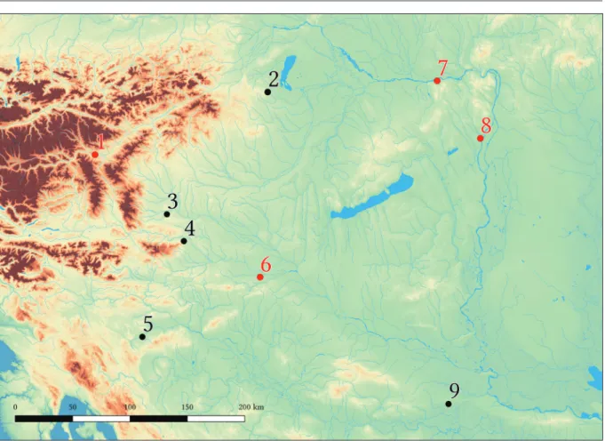
In Austria, the necropolis and the Early Iron Age sett lement of Strett weg and the tumuli of Grossklein; in Slovenia, the Early Iron Age site complex of Poštela (sett lement, fl at cemetery, tumuli fi eld) and the Novo mesto tumuli fi eld; in Croatia the tumuli of Jalžabet/Martijanec and the Kaptol site complex (tumuli and Early Iron Age sett lement) belong to the project (Fig. 1).
Methodology
Th e listed sites, both in their terrain and modern land cover, are of diff erent character and their preliminary researchedness is signifi cantly diff erent. Th is defi nes both research possi- bilities and the strategy, and of course it has an impact on the results during the timespan of the project. Th e sites of Százhalombatt a and Sütt ő, as well as the tumuli fi elds of Strett weg and Jalžabet/Martijanec lie in an approximate fl at area, while the sett lement of Strett weg, the tumuli of Grossklein and Novo mesto, as well as the Sopron–Várhely, Poštela and Kaptol site complexes are in the mountains. Th e current land cover is in correlation with these diff er- ences in the terrain; most of the necropolises of Sütt ő are under large-fi eld arable cultivation and the parcel size is relatively large also in the case of the tumuli fi eld of Strett weg. Narrow, so-called “belt-parcels” are dominant in Jalžabet/Martijanec, while in Százhalombatt a, mosaic cultivation (interconnected, various shaped closed gardens, orchards, arable fi elds, and hay- fi elds) is characteristic. Th e necropolis of Novo mesto is covered by grove, the sett lement is covered by forest and there is a similarly mixed land cover at the Grossklein site, while the sett lement of Strett weg, Sopron–Várhely, Poštela and Kaptol are entirely in the forest.
345 Report on magnetometer geophysical surveys conducted in Hungary, Austria and Croatia
It is a fortunate circumstance that ALS-based terrain models are available for project partners from all partially or fully wooded surfaces (Strettweg, Grossklein, Novo mesto, Sopron–Várhely, Poštela and Kaptol).1 It should be noted that there are also tumuli/earthworks covered by small wooded parts in Százhalombatta, Süttő and Jalžabet/Martijanec, therefore one of the project’s main objectives is to carry out ALS in these areas as well. Aerial archaeological pho- tography was successful in Százhalombatta and Süttő before the project.2 In 2017, test drone photography at Százhalombatta and Süttő, moreover, UAV and helicopter aerial photography were carried out in Százhalombatta, primarily for the expansion of 3D reconstruction oppor- tunities.
On a smaller scale, geophysical surveys were also carried out prior to the EU program:
there were magnetometer measurements at the Százhalombatta tumuli field in 2012–
1 Without any claim to completeness: Tiefengraber 2015, 541; Mele 2015, 502; Czajlik et al. 2012, 68;
Mlekuž – Črešnar 2014; Ceković et al. n.d.
2 Czajlik et al. 2016, 60; Czajlik et al. 2015, 64–70.
Fig. 1. Early Iron Age sites included in the program. 1 – Strettweg bei Judenburg (Obersteiermark, Austria), 2 – Sopron–Várhely (Győr-Moson-Sopron county, Hungary), 3 – Grossklein bei Leibnitz (Steiermark, Austria), 4 – Poštela near Razvanje, (Maribor, Slovenia), 5 – Novo mesto (Lower Carniola, Slovenia), 6 – Jalžabet/Martijanec (Varasd county, Croatia), 7 – Süttő – Nagysánctető, Kissánc, Sánci- dűlő and Sáncföldek (Komárom-Esztergom county, Hungary), 8 – Érd/Százhalombatta–Sánc-hegy and Százhalom (Pest county, Magyarország), 9 – Kaptol (Požega-Slavonia County, Croatia). Locations where the team of the Institute of Archaeological Sciences – Eötvös Loránd University conducted ge- ophysical surveys in 2017 are marked in red (A. Bödőcs).
346
Zoltán Czajlik – Saša Kovačević – Georg Tiefengraber et al.
2014,3 at Süttő in 2014–2016,4 and at Strettweg in 2011–2014,5 and magnetic suscepti- bility measurement, georadar (GPR), electrical resistivity, electrical resistivity tomog- raphy (ERT) surveys at Poštela, and georadar on Falkenberg/Strettweg in 2014-2015.6 According to previous experience, the Institute of Archaeological Sciences of the Eötvös Loránd University is responsible for the continuation of magnetometer surveys in Százhalombatta, Süt- tő, Strettweg, Jalžabet/Martijanec and Sopron–Várhely, while the group from the University of Ljubljana continued the research in Poštela and Kaptol and started surveying Grossklein and Jalžabet. In addition to the use of remote sensing methods, the participants of the project carried out smaller-larger ground surveys, collecting surface finds on the surveyed sites. Test excava- tions in 2017, according to the program, took place at Strettweg, Grossklein, Jalžabet and Kaptol.
Geophysical surveys were started on behalf of the Institute of Archaeological Sciences of the Eötvös Loránd University on 11 February 2017 and the last measurement was on 13 No- vember. The instrumental background was partly covered by the Department of Geophysics of the Eötvös Loránd University (László Lenkey, 2 GSM19 Overhauser magnetometers) and partly by Balázs Holl (Trimble GeoXH GPS). From August 2017, we have been working with the devices acquired in the framework of the project (2 GSM19W Overhauser magnetometers, Trimble Geo 7 GPS). Devices were arranged and used identically all year round at all sites. The
3 Czajlik et al. 2016, 60-65.
4 Czajlik et al. 2015, Fig. 8.
5 Tiefengraber 2015, 543.
6 Mušič et al. 2014, 2015.
Fig. 2. Érd/Százhalombatta – Százhalom, tumuli field. Areas surveyed in 2017 using magnetometer geophysical method on the topographic map (L. Rupnik).
347 Report on magnetometer geophysical surveys conducted in Hungary, Austria and Croatia measurement of the temporal change of the magnetic data was solved by local base measure- ments, and the rover unit proceeded in variometer layout, the distance between the lines was 0.75 m and the distance within the line was 0.5 m. The GPS data were corrected on the basis of base stations. At every location we tried to carry out the measurements in ideal conditions under the given circumstances. On arable lands, this meant the avoidance of deep-ploughed or seed-bed areas, therefore surveys were usually conducted in the pre-sowing phase, or im- mediately after harvesting. The orchards of Százhalombatta, after consulting with the owners, were surveyed after pruning, but before flowering. It should be noted, that depending on the type and age of the orchard, a number of lines have been omitted from the measurements, which may cause minor or major problems on the resulted anomaly map but does not gener- ally affect the final evaluation.
The most challenging task was surveying the Százhalombatta site of mosaic cultivation, where 46 hectares was measured in 25 working days (Fig. 2). At Süttő, under the circumstance of large parcel cultivation, nine hectares in four days; at Strettweg, on the measurable areas 17 hectares in eight days, and at Jalžabet, six hectares in three days were surveyed with the magnetometer.
In July 2017, GPR measurements were also carried out experimentally at Százhalombatta and Jalžabet, however, archaeological structures were not detected using this method.
Since the fieldwork on two out of the four Hungarian sites under research is related to the earlier Early Iron Age research programs of the Institute of Archaeological Sciences (Eötvös Loránd University), they are presented in more detail by a brief description of their research history. At the same time, the Strettweg site was previously researched by the University of Graz (Susanne and Georg Tiefengraber), and the research on Jalžabet was conducted by the Zagreb Institute of Archaeology (Saša Kovačevič).
Results
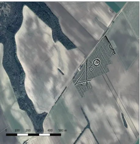
Érd/Százhalombatta–Százhalom and Százhalombatta–Sánc-hegy (Transdanubia, Hungary)
South of Budapest at Érd/Százhalombatta is the beginning of a characteristic loess wall with the river Danube flowing directly by its foot with minor interruptions almost until the valley of Dráva, which represents the eastern border of Transdanubia. At its highest point to the north, in an area accentuated from south and west by a system of natural loess rifts, was the settlement of the Early Bronze Age Nagyrév culture, then the hillfort of the Bronze Age Vatya culture and later – in an expanded area – the Early Iron Age settlement established. The area is still inaccessible from the direction of the Danube, where a 40-45 m tall concave bank is the border. To the north and to the west, emerged the Early Iron Age tumuli field (Százhalom).
In a study published in 2016, it was attempted to compile a detailed topographic research his- tory of the site which was first mentioned in written sources as Zazholm at the end of the 13th century, thus only the available traditional ground survey data will be supplemented here.7 The topographic data, and 140 years of research history on the tumuli field between Érd and Százhalombatta and the settlement of Százhalombatta–Sánc-hegy in Százhalombatta, were summarized by István Torma in 1986 in the 7th volume of the Archaeological Topography of
7 Czajlik et al. 2016, 57–59; T. Németh et al. 2016, 291–292.
348
Zoltán Czajlik – Saša Kovačević – Georg Tiefengraber et al.
Hungary (MRT).8 From his description it appears that a systematic ground survey, including the collection of surface finds was not carried out – the field work was only intended to verify a map of the tumuli field,9 which was based on an aerial photograph made in 1953. Therefore, the boundaries of both sites were determined on the basis of the visible tumuli, the earth- works of the fortified settlement and the archaeological phenomena identified on the 1953 aerial photograph.
Based on the regular aerial archaeological surveys since 2001 and the processing of archive aerial photographs, it has become clear that the necropolis is larger than previously recorded.
In the course of the magnetometer geophysical surveys started in 2012, it was identified a large number of circular structures not only in the previously empty areas without archaeo- logical phenomena, but in some cases, in line with the data from aerial photography, beyond the known boundaries of the site, which led to the questioning of fundamental topographic data. Thus, from 2013 onwards, the extension of the necropolis was one of the key issues of the research program.
Based on the previous map and the aerial photography, largely due to the aerial archaeological survey in March 2014, that was carried out in very good vegetation and weather conditions, the limits of the area with the circular phenomena could be suspected.10 This was confirmed by magnetometer surveys to the north, west and south in 2017, but it is not identified the edge
8 Dinnyés et al. 1986, 27, sites 1–2; 228–233, Pl. 37.
9 Dinnyés et al. 1986, 229, Fig. 26.
10 Czajlik et al. 2016, Fig. 5.
Fig. 3. Solitary(?) encircled phenomenon (trace of an Early Iron Age tumulus?) east to the Százhalom- batta tumuli field (Z. Czajlik, 9 June 2017).
349 Report on magnetometer geophysical surveys conducted in Hungary, Austria and Croatia
of the cemetery to the east yet. One of the reasons for this is that due to the closed gardens east of the modern road between Érd and Százhalombatta, there are iron fences and air cables under voltage that are technically and physically restraints for magnetometer measurements, and the boundary cannot be defined clearly on the basis of the results from the measurable areas.
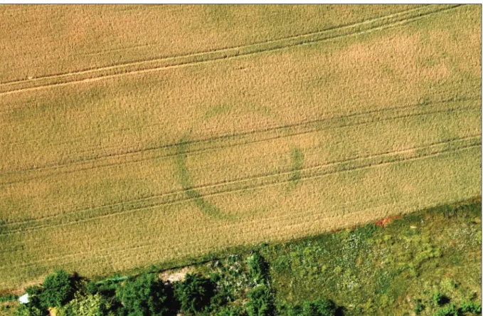
The situation became more complicated with the results of the aerial photography carried out in June 2017, which – in addition to the previous photographs with uncertain interpretation – clearly indicated the remains of some solitary tumuli(?) east of this zone (Fig. 3).11 Just a little later, in July 2017, we observed new phenomena in the magnetometer survey south of the above-mentioned circular ditches, north of the fortified settlement. Remains of a wider, 130 m long, NE–SW oriented straight trench(?) and a further ditch section can be observed in the magnetic anomaly map, which are only 100–200 m north from the Fécamp-type Celtic rampart (Fig. 4).
In order to facilitate the interpretation of the data obtained by remote sensing methods, we started systematic surface surveys in the southern area of the necropolis from March 2017 (Fig. 5). These clearly indicated that there was no significant space without finds between the circular structures and the fortified settlement. According to our present knowledge, in line with the results of the smaller ground surveys by Gabriella T. Németh in the 2010s, the most likely explanation seems to be that the Early Iron Age settlement was much larger than previ-
11 The aerial archaeological research was supported by the NRDIO 111058 project.
Fig. 4. Trace of NE–SW oriented ditches(?) on the magnetic anomaly map (red arrows), north of the Fécamp-type Celtic rampart (yellow arrow). Implanted in GE-imagery of 31 July 2009 (S. Puszta – Z. Czajlik).
350
Zoltán Czajlik – Saša Kovačević – Georg Tiefengraber et al.
ously assumed on the basis of the imposing Iron Age earthworks. Another important result of the ground surveys is that in the southern zone, the presence of surface finds draws a different picture of the extension of the site, than it would be assumed on the basis of the geophysical surveys, so this work is planned to be extended to all accessible parts of the necropolis in 2018, beyond the boundaries defined by the circular ditches and other features.
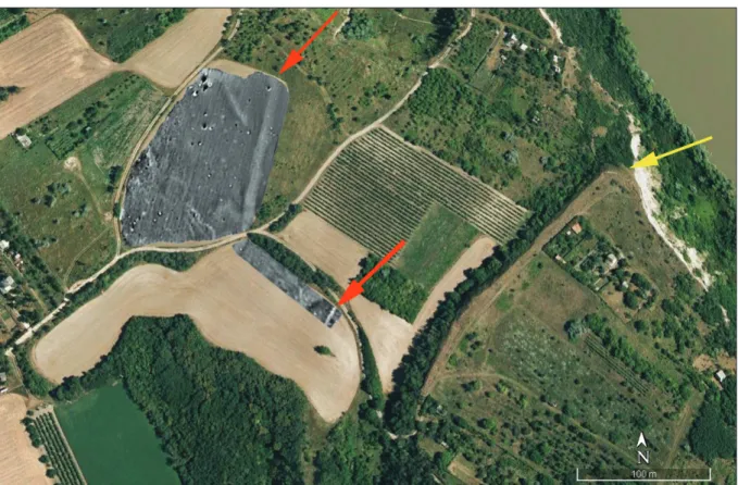
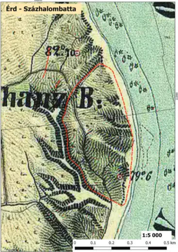
Summarizing the results on the internal division of the site, the size of the settlement to the west, between the tumuli and the loess wall next to the Danube is reaching 10 hectares, of which probably 5 hectares area was fortified. The current northern fortification is a Fécamp-type Celtic rampart, while the southern part of the fortification has been destroyed because of the brick factory activity since the end of the 19th century – now it can be recon- structed only with old maps (Fig. 6). The total area of the tumuli field and its associated circu- lar ditches is at least 75 hectares. The number of circular phenomena is 365 on the basis of the 2017 geophysical surveys (and aerial photography), a number which can reach or even exceed 400 by the size of the remaining, measurable areas.
Süttő–Nagysánctető, Kissánc, Sánci-dűlő and Sáncföldek (Transdanubia, Hungary) Similarly to Érd/Százhalombatta, the Early Iron Age settlements and cemeteries were estab- lished on the top of the loess plateau next to the Danube. As detailed in our previous publica- tion, there were two settlements on the loess wall cut up by gullies, sloping into the Danube Fig. 5. Areas surveyed with systematic surface survey in the southern part of the Százhalombatta tumuli field (L. Rupnik).
351 Report on magnetometer geophysical surveys conducted in Hungary, Austria and Croatia (the fall is approx. 40 m), and the necropolises were further south.12 However, it is a significant difference that this series of loess plateaus is much shorter, and the Neszmély–Süttő section is bordered by mountains from the south, the Gerecse mountain range of more than 600 m.13 This made possible the formation of a unique micro-region, which was connected to the ter- ritories north of the Danube by cultural ties in prehistoric times.
The first topographic research of the Süttő site identified in the 1930s was carried out between 1968 and 1971 by István Horváth and István Torma in the works of the Archaeological To- pography of Hungary. In addition to the identification of a part of the tumuli, on the basis of the two previously known hillforts, an Early Iron Age site complex similar to Százhalombatta have been documented.14 Both the Nagysánctető settlement and the tumuli, as well as the flat cemetery found in the meantime, were part of the research programs of Éva Vadász and Gábor Vékony between 1978 and 1990, but these could not be processed and evaluated before they deceased. The archaeological evaluation of their previous research is currently carried out by Katalin Novinszki-Groma, in the framework of her PhD-dissertation.15
12 Czajlik et al. 2015, 62–66.
13 Czajlik et al. 2015, Fig. 4.
14 Horváth et al. 1979, 311–313.
15 Preliminary reports on the matter: Novinszki-Groma 2017a; 2017b.
Fig. 6. Százhalombatta–Földvár. Late Iron Age fortified settlement. Topographic reconstruction us- ing the Second Military Survey (1806–1869) implanted the newly identified ditches(?): see Fig. 4. (Z.
Czajlik – B. Holl).
352
Zoltán Czajlik – Saša Kovačević – Georg Tiefengraber et al.
The detailed topographic research of the site that was mainly known previously by Éva Vadász’s publications16 was initiated in 2013. In addition to the regular aerial archaeological prospection, we conducted geophysical magnetometer surveys in 2014. Results of these sur- veys, together with a detailed evaluation of preceding research history, topography and geo- morphology data, were published in 2015.17 In cooperation with the Institute of Archaeology of the Hungarian Academy of Sciences, we carried out Overhauser and fluxgate magnetome- ters comparative measurements in 2016. In the course of the simultaneously conducted large- scale field surveys and drone aerial photography, traces of a previously unknown Early Iron Age settlement west of the southern tumuli group were observed.
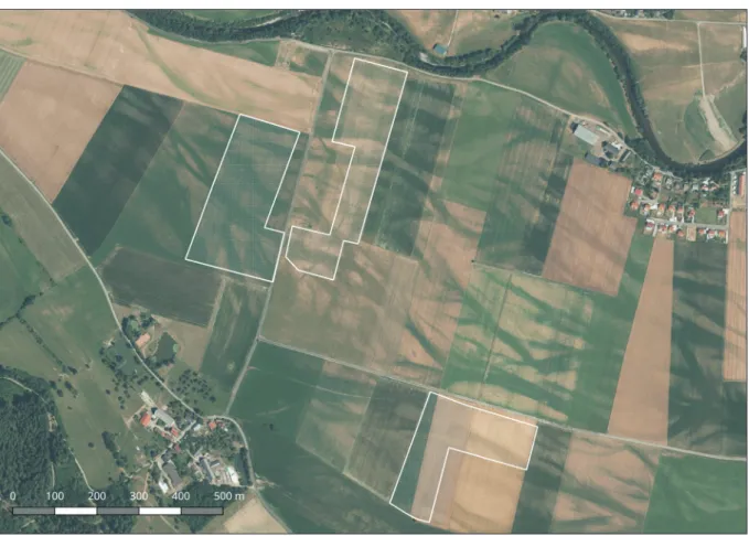
In the framework of the Iron Age Danube project, geophysical surveys were carried out in 2017 on the southernmost part of the site complex, south of the dirt road connecting Süttő and Dunaszentmiklós (Fig. 7). The most prominent circular ditch encircles a relatively large tumulus. East of that, also encircled with a circular ditch, there is the second tallest tumulus of the tumuli group south of the dirt road, researched by Éva Vadász during her excavations between 1978 and 1982. Southwest of the large mound to the west, and south of the excavated tumulus, the circular ditches on the magnetic anomaly map indicate much flatter tumuli, also known from earlier maps published by Éva Vadász. However, the small circular ditch south- east of the large mound (Fig. 8) to the west is new.
16 Vadász 1983, 1986.
17 Czajlik et al. 2015.
Fig. 7. Süttő–Sáncföldek. Magnetic anomaly map based on the 2017 magnetometer surveys implanted in GE-imagery 29 March 2017 (S. Puszta – B. Holl).
353 Report on magnetometer geophysical surveys conducted in Hungary, Austria and Croatia
In December 2017, field surveys were carried out to document the boundaries of the Early Iron Age settlement identified west of the southern tumuli group in July 2016. During the ex- amination of the surrounding areas we identified a grave that could be dated to the transition of the Late Bronze Age/Early Iron Age.
Strettweg bei Judenburg (Obersteiermark, Austria)
The site of Stettweg, north of the Mur river and south of the Pöls creek, is an alluvial valley surrounded by mountains, with well-observable traces of modern iron mining in the adjacent areas, e.g. on Falkenberg (not so extraordinary in Styria). The research area is entirely under agricultural utilization, mainly on smaller or larger parcels, cultivating arable grain, and a rela- tively dense asphalt road network facilitates the traffic between the villages and majors (Fig. 9).
The research of the Strettweg necropolis – similarly to Százhalombatta – Százhalom – can be traced to the 19th century, when the Strettweg Cult Wagon came to light. A sensational result of modern research was the excavation of a group of almost destroyed princely tumuli (Tumu- lus II “Helmet grave”, Tumulus III and “Bleikolmhügel”) and especially the re-identification of the famous “Cult Wagon grave” (Tumulus I).18 At that time, some older aerial archaeological surveys, which were probably confined to a few flights, could not detect further burials in the immediate vicinity of the princely grave,19 but interesting further traces of questionable
18 Egg 1996.
19 Egg 1996, Pl. 2/1.
Fig. 8. Süttő–Sáncföldek. Early Iron Age burial mound on a drone photograph (L. Rupnik, 24 March 2017).
354
Zoltán Czajlik – Saša Kovačević – Georg Tiefengraber et al.
burials (Pöls, Schloss Gusterheim) could be identified in the Pölsbach valley.20 On the other hand, some new aerial photos show many crop marks from circular ditches in the area of Waltersdorf and Strettweg. These flight data were, ordered by the county of Styria (GIS Stei- ermark) in the dry summer of 2013. From 2011–2014, Susanne and Georg Tiefengraber initi- ated large-scale magnetic geophysical research using a multichannel fluxgate magnetometer.
The results showed a varied picture, besides the burials enclosed by large, presumably deep circular ditches, circular ditches of half or one-third of their diameter are also present. The phenomena do not fill the available space evenly, they form groups, occasionally relatively far from each other.21 From 2012, archaeological excavations have also started, with the research of the larger circular ditches, but also of smaller circular (Tumuli IV–IX in the grave-group
“Hauptgruppe”) and rectangular ditches respectively graves (grave-group “Pölsweg).22
Due to the late sowing, we had to carry out the measurements in the grave-groups “Müllweg”,
“Pölsweg” and “Totenweg” under relatively good weather conditions but on many ploughed surfaces, which did not help to achieve good results. It was surprising that we experienced a very strong anomaly along the road north of Waltersdorf (grave-group “Müllweg”), probably due to the filling of the base of the road with iron-containing rock and iron slag. Our measure- ments have detected the filled paleomeanders generally well, which are also visible on some
20 Egg 1996, Pl. 2/2.
21 Tiefengraber 2015, 543.
22 Tiefengraber 2013, 313–316; Tiefengraber – Tiefengraber 2015, 245–264.
Fig. 9. Magnetometer survey areas in the Pölsbach valley, between Waltersdorf and Pölsweg, implanted in high resolution orthofoto (GIS Steiermark 2013, A. Bödőcs).
355 Report on magnetometer geophysical surveys conducted in Hungary, Austria and Croatia of the aerial photographs showing that the Pöls used to have a curvier water-course, more south of its present location. Due to the parcel boundaries, the ploughed surface and “extra”
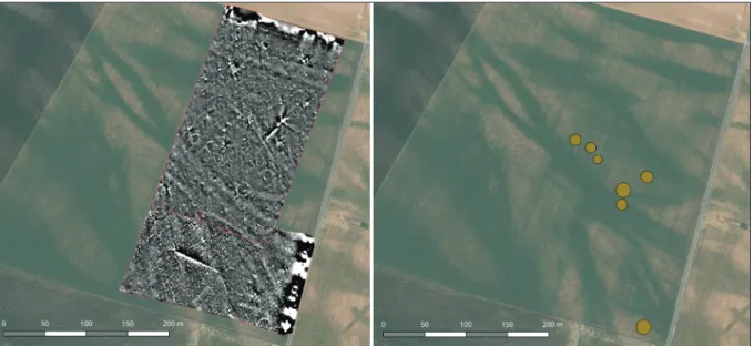
magnetic anomalies, the background of the surveyed areas was more uneven than average, however, we could identify two small groups of smaller circular features (Fig. 10). Among them, in the vicinity of the most remote, westernmost one from the princely grave, Iron Age ceramics were collected on the surface, indicating that measurements would be worthwhile to continue westward in 2018.
Jalžabet–Bistričak (Podravina, Croatia)
The area called Podravina in Croatian and Dráva-mente in Hungarian is a 15 to 30 km wide alluvial plain belonging to the Drava Valley, which is bordered by the Somogy and Baranya Hills from the north, and by Macelj, Toplička Gora, Kalnik, Bilogora and Papuk Mountains from the south. To the south of Drava, prehistoric settlements (and cemeteries) were emerged on the Quaternary terraces bordering the alluvial plain.23
Following the previous studies of Marina Šimek, the research history of the Jalžabet/Martijan- ec part of the Podravina region has been summarized recently by her and Saša Kovačević.24 The most important conclusions of these studies that the Early Iron Age tumuli of the re- gion began to be surveyed in 1956,25 devoting the greatest attention to the great mounds of Martijanec and Jalžabet. The latter is one of the largest tumuli of the Eastern Hallstatt Circle with a diameter of 75 m and a height of 12 m. The shape of the mound called Gomila is also interesting, which suggests a truncated cone. In 1963, on the northern and southern sides, research trenches were excavated, in which an artificial pebbled level (mantle of the tumuli?) was reached.26 130 m east of Tumulus I, Marina Šimek identified and excavated the remains of
23 Šimek – Kovačević 2014, 231–232.
24 Šimek 1998, 493; 2004; Šimek – Kovačević 2014.
25 Vinski-Gasparini 1961, 39, Fig. 3.
26 Šimek – Kovačević 2014, 234, Fig. 2.
Fig. 10. Magnetic anomaly map of recently discovered small circular ditches (tumuli?) north to Wal- tersdorf, implanted in high resolution orthofoto (GIS Steiermark 2013, S. Puszta – A. Bödőcs).
356
Zoltán Czajlik – Saša Kovačević – Georg Tiefengraber et al.
Tumulus II, where a burial chamber made from wood and stone with dromos were observed.27 Although Tumulus II was flattened, the remains of the mantle made from pebbles were found.
In 1989, geoelectric measurements were carried out in north-south direction through the two tumuli, and the third section crossed the two tumulus east-west, which was pioneering work for the time being in Croatia.28 In 2016, a fluxgate magnetometer survey was conducted by Cornelius Meyer on behalf of the Eastern Atlas geophysical company from Berlin at the Gomila and its surroundings, and a ground penetrating radar (GPR) survey was also carried out on a smaller surface at the top of the Gomila.
Cultivation in narrow parcels is characteristic for the whole region, with the disadvantage that crop rotations are mostly different in adjacent parcels (Fig. 11). Therefore, during the first series of measurements carried out in April 2017, we only surveyed areas not yet ploughed or sown, as well as the top and the side of the tumulus, as long as its slope allowed it. In July 2017 we carried out measurements on the missing parts following the harvest of autumn sown grain, and started experiments with the GPR. An unexpected difficulty was on both occasions that there was often a significant difference in height between the parcels and occasionally even a smaller trench formed, which did not allow the gapless joining of the surveyed areas.
Partly due to this, modern cultivation trails have remained the dominant elements of the magnetic anomaly map. It is not possible to observe the incidental remains of the excavated tumulus and certainly the disturbance caused in 1963 by the trenches north and south of the
27 Šimek 2004, 126–127, Fig. 40.
28 Baturić et al. 1990; Šimek – Kovačević 2014, 235, Map 3, Fig. 5.
Fig. 11. Magnetometer survey areas in Jalžabet – Bistričak (Podravina, Croatia) implanted in DOF5 (Digitalna Ortofoto Karta 1:5000, A. Bödőcs).
357 Report on magnetometer geophysical surveys conducted in Hungary, Austria and Croatia
Gomila do not assist in the evaluation either. There are few archaeological phenomena on the map for that matter, a larger pit (ditch initiative?) on the north-western – northern side of the Gomila=Tumulus I (and the traces of the excavated Tumulus II) should be mentioned here.
Results of the magnotemeter survey done in 2016 and 2017 were indicative and later were tested by archaeological excavation during Iron-Age-Danube Interreg DTP Camp Jalžabet in September 2017. During September Camp, 3D electrical resistivity tomography survey was conducted at the top of the Gomila by Brane Mušić from University of Ljubljana. One of the indicative results after archaeological excavation in Jalžabet in September 2017 is that soil is very rich with alluvial iron. This can help during future geophysical surveys in Jalžabet area.
The approximately flat surface on the top of the truncated cone-shaped mound (Gomila) made it possible to carry out measurements there as well (Fig. 12). A few months later, in September 2017 became clear that the most significant anomaly was probably caused by the illegal tunnel through which they reached the burial chamber and robbed the tumulus of unparalleled in- terest. After robbery was discovered, with intervention funds of the Ministry of culture of the Republic of Croatia Institute of archaeology started rescue excavation of Gomila. The excava- tion, which proved to be very demanding, complex and expensive, will be continued in 2018.
Summary, perspectives
In 2017, in the framework of the Interreg DTP Iron Age Danube project, we carried out mag- netometer geophysical survey at four important Early Iron Age necropolises in three coun- tries, on altogether 76 hectares. Research has relied on previous topographic programs in each case, which helped to organize and significantly increased the effectiveness of the surveys.
Fig. 12. Magnetic anomaly map in Jalžabet – Bistričak (Podravina, Croatia) implanted in Croatian base map 1:5000 (A. Bödőcs).
358
Zoltán Czajlik – Saša Kovačević – Georg Tiefengraber et al.
We worked with methods developed by Sándor Puszta and Balázs Holl, and later by us in our own projects for decades throughout the whole period, only the details of data processing can be different between the measurements.
In general, it can be stated that surveys on the loess plateaus provided clearer, more easily evaluable results than the ones in the alluvial areas (Strettweg) and their bordering Quater- nary terrace surfaces (Jalžabet). This is mainly due to the greater geological inhomogeneity of the latter areas, and secondarily, in the latter case the small-parcel agricultural cultivation (Jalžabet) and special local conditions (ferriferous inhomogeneities?).
The most important task of the next period is to prepare the ALS survey in the zone of Jalžabet–
Martijanec and the execution of geophysical surveys based on the existing ALS-based DTM at the – in this regard unresearched – site of Sopron–Várhely. At the same time, aerial archae- ological photography and magnetometer surveys must be continued on the sites in focus, as well as systematic field surveys in larger areas for the interpretation of archaeological phe- nomena observed with various methods.
Acknowledgements
The archaeological prospections were funded by Interreg DTP1-1-248-2.2. ˮIron Age Dan- ube – Monumentalized Early Iron Age Landscapes in the Danube river basin” project. In the geophysical surveys participated András Bödőcs, András Jáky, Katalin Novinszki-Groma, László Rupnik and the students and doctoral students (Rebeka Gergácz, Dalma Kollerits, Bence Simon, Bence Soós, Zsófia Sörös) of the Institute of Archaeological Sciences of the Eötvös Loránd University, the data were processed by Sándor Puszta.
References
Baturic, I. et al. 1990: Plitko geoelektrično sondiranje arheološkog lokaliteta Bistričak kraj Jalžabeta, laborate, Varaždin, arhiva AO GMV.
Ceković, M. –Potrebica, H. – Mlekuž, D. 2015: The Lost Hillfort – Rediscovering forgotten landscapes with Lidar. Poster presentation. Santiago de Compostela. Poster publication: https://www.aca- demia.edu/17868224/The_Lost_Hillfort_rediscovering_forgotten_landscapes_with_lidar Czajlik, Z. – Király, G. – Czövek, A. – Holl, B. – Brolly, G. 2012: The Application of Remote Sens-
ing Technology and Geophysical Methods in the Topographic Survey of Early Iron Age Burial Tumuli in Transdanubia. In: Berecki, S. (ed.): Iron Age Rites and Rituals in the Carpathian Basin.
Proceedings of the International Colloquium from Târgu Mureş, October 2011. Cluj-Napoca, 65–76.
Czajlik, Z. – Novinszki-Groma, K. – Horváth, A. 2015: Données relatives à la topographie de la microrégion de Süttő au Premier âge du Fer. In: Borhy, L. – Dévai, K. – Tankó, K. (eds.): Studia archaeologica Nicolae Szabó LXXV annos nato dedicata. Budapest, 59–74.
Czajlik, Z. – Holl, B. – T. Németh, G. – Puszta, S. – Vicze, M. 2016: New results in the topograph- ic research on the Early Iron Age tumulus cemetery at Érd-Százhalombatta (Kom. Pest/H).
Archäologisches Korrespondenzblatt 46/1, 57–73.
Dinnyés, I. – Kővári, K. – Lovag, Zs. – Tettemanti, S. – Topál, J. – Torma, I. 1986: Magyarország Régészeti Topográfiája 7. Pest megye régészeti topográfiája. A budai és szentendrei járás. Budapest.
Egg, M. 1996: Das hallstattzeitliche Fürstengrab von Strettweg bei Judenburg in der Obersteiermark.
Monographien des RGZM 37. Bonn – Mainz.
Horváth I. – H. Kelemen, M. – Torma, I. 1979: Magyarország Régészeti Topográfiája 5. Komárom megye régészeti topográfiája. Esztergom és a dorogi járás. Budapest.
359 Report on magnetometer geophysical surveys conducted in Hungary, Austria and Croatia Mele, M. 2015: Eine ausgewählte Fundstelle: Der Burgstallkogel bei Kleinklein (Gemeinde Grossklein).
In: Hebert, B. (ed.): Urgeschichte und Römerzeit in der Steiermark. Wien, 497–509.
Mlekuž, D. – Črešnar, M. 2014: Landscape and identity politics of the Poštela hillfort (Pokrajina in politika identitet utrjene naselbine na Pošteli). In: Tecco-Hvala, S. (ed.): Studia Praehistorica in Honorem Janez Dular. Opera Institutii Archaeologici Sloveniae 30. Ljubljana, 197–211.
Mušič, B. – Črešnar, M. – Medarić, I. 2014: Možnosti geofizikalnih raziskav na najdiščih iz starejše železne dobe. Primer Poštele pri Mariboru (Possibilities for geophysical research on sites dated to the Early Iron Age. Case study of Poštela near Maribor/Slovenia). Arheo 31, 19–47.
Mušič, B. – Vinazza, M. – Črešnar, M. – Medarić, I. 2015: Integrirane neinvazivne raziskave in terensko preverjanje. Izkušnje s prazgodovinskih najdišč severovzhodne Slovenije (Integrated non-invasive research and ground truthing. Experiences from prehistoric sites in north-eastern Slovenia). Arheo 32, 37–64.
T. Németh, G. – Czajlik, Z. – Novinszki-Groma, K. – Jáky, A. 2016: Short report on the archaeo- logical research of the burial mounds no. 64. and no. 49. at Érd-Százhalombatta. Dissertationes Archaeologicae 3/4, 291–306.
Novinszki-Groma, K. 2017a: New data on the Burial Customs in the Early Iron Age on the basis of Examples from Northeast-Transdanubia. In: Beljak Pažinová, N. – Borzová, Z. (eds.): Sedem- decénií Petra Romsauera. Studia Historica Nitriensia/Supplementum. Nitra, 155–171.
Novinszki-Groma, K. 2017b: Inhumation graves at the Early Iron Age cemetery of Süttő. In: Myrošša- jová, E. – Pare, C. – Stegmann-Rajtár, S. (eds.): Das nördliche Karpathenbecken in der Hall- stattzeit. Wirtschaft, Handel und Kommunikation in früheisenzeitlichen Gesellschaften zwischen Ostalpen und Westpannonien. Budapest, 471–497.
Šimek, M. 1998: Ein Grabhügel mit Pferdebestattung bei Jalžabet, Kroatien. In: Hänsel, B. – Mach- nik, J. (eds.): Das Karpatenbecken und die osteuropäische Steppe. Nomadenbewegungen und Kulturaustauschin den vorchristlichen Metallzeiten (4000–500 v. Chr.). München – Rahden/
Westfahlen, 493–509.
Šimek, M. 2004: Grupa Martijanec-Kaptol (Martijanec-Kaptol Group – Martijanec-Kaptol-Gruppe).
In: Balen-Letunić, D. (ed.): Ratnici na razmedu Istoka i Zapada. Starije Željeznodoba u konti- nentalnoj Hrvatskoj. Zagreb, 79–130.
Šimek, M. – Kovačević, S. 2014: Jalžabet – Bistričak: u susretnovimistraživanja (Jalžabet Bistričak:
On the eve of the new research). Prilozi Instituta za arheologiju u Zagrebu 31, 231–238.
Tiefengraber, G. 2013: KG Waltersdorf. Fundberichte Österreichs 51, 313–316.
Tiefengraber, G. 2015: Eine ausgewählte Fundstelle: Der Falkenberg und die Fürstengräber von Strettweg. In: Hebert, B. – Hesch, O. – Brunner, M. (eds.): Urgeschichte und Römerzeit in der Steiermark. Wien, 541–551.
Tiefengraber, G. – Tiefengraber, S. 2015: Zum Stand der Erforschung hallstattzeitlicher “Zentral- siedlungen” in der Obersteiermark. In: Gutjahr, Ch. – Tiefengraber, G. (eds.): Beiträge zur Hallstattzeit am Rande der Südostalpen. Internationale Archäologie. Arbeitsgemeinschaft. Sym- posium. Tagung. Kongress 19 = Hengist-Studien Band 3, Rahden/Westf., 217–275.
Vadász, É. 1983: Előzetes jelentés egy koravaskori halomsír feltárásáról Süttőn (Vorbericht über die Erschliessung eines früheisenzeitlichen Hügels in Süttő). Communicationes Archaeologicae Hungariae 3, 19–54.
Vadász, É. 1986: Das früheisenzeitliche Gräberfeld von Süttő. Mitteilungen des Archäologischen Insti- tuts der Ungarischen Akademie der Wissenschaften. Beiheft 3, 251–257; 471–475.
Vinski-Gasparini, K. 1961: Iskopavanje kneževskog tumulusa kod Martijanca u Podravini. Vjestnik Arheološkog muzeja u Zagrebu 3/2, 39–66.