Dissertationes Archaeologicae
ex Instituto Archaeologico
Universitatis de Rolando Eötvös nominatae Ser. 3. No. 3.
Budapest 2015
Dissertationes Archaeologicae ex Instituto Archaeologico Universitatis de Rolando Eötvös nominatae
Ser. 3. No. 3.
Editor-in-chief:
Dávid Bartus Editorial board:
László Bartosiewicz László Borhy Zoltán Czajlik
István Feld Gábor Kalla
Pál Raczky Miklós Szabó Tivadar Vida Technical editors:
Dávid Bartus Gábor Váczi Dániel Szabó
Proofreading:
Szilvia Szöllősi Zsófia Kondé
Available online at http://dissarch.elte.hu Contact: dissarch@btk.elte.hu
© Eötvös Loránd University, Institute of Archaeological Sciences
Budapest 2015
Contents
Zoltán Czajlik 7
René Goguey (1921 – 2015). Pionnier de l’archéologie aérienne en France et en Hongrie
Articles
Péter Mali 9
Tumulus Period settlement of Hosszúhetény-Ormánd
Gábor Ilon 27
Cemetery of the late Tumulus – early Urnfield period at Balatonfűzfő, Hungary
Zoltán Czajlik – Balázs Holl 59
Zur topographische Forschung der Hügelgräberfelder in Ungarn
Zsolt Mráv – István A. Vida – József Géza Kiss 71
Constitution for the auxiliary units of an uncertain province issued 2 July (?) 133 on a new military diploma
Lajos Juhász 77
Bronze head with Suebian nodus from Aquincum
Kata Dévai 83
The secondary glass workshop in the civil town of Brigetio
Bence Simon 105
Roman settlement pattern and LCP modelling in ancient North-Eastern Pannonia (Hungary)
Bence Vágvölgyi 127
Quantitative and GIS-based archaeological analysis of the Late Roman rural settlement of Ács-Kovács-rétek
Lőrinc Timár 191
Barbarico more testudinata. The Roman image of Barbarian houses
Field reports
Zsolt Mester – Norbert Faragó – Attila Király 203
Report on the excavation at Páli-Dombok in 2015
Ágnes Király – Krisztián Tóth 213
Preliminary Report on the Middle Neolithic Well from Sajószentpéter (North-Eastern Hungary)
András Füzesi – Dávid Bartus – Kristóf Fülöp – Lajos Juhász – László Rupnik –
Zsuzsanna Siklósi – Gábor V. Szabó – Márton Szilágyi – Gábor Váczi 223 Preliminary report on the field surveys and excavations in the vicinity of Berettyóújfalu
Márton Szilágyi 241
Test excavations in the vicinity of Cserkeszőlő (Jász-Nagykun-Szolnok County, Hungary)
Dávid Bartus – László Borhy – Emese Számadó 245
Short report on the excavations in Brigetio in 2015
Dóra Hegyi 263
Short report on the excavations in the Castle of Sátoraljaújhely in 2015
Maxim Mordovin 269
New results of the excavations at the Saint James’ Pauline friary and at the Castle Čabraď
Thesis abstracts
Krisztina Hoppál 285
Contextualizing the comparative perceptions of Rome and China through written sources and archaeological data
Lajos Juhász 303
The iconography of the Roman province personifications and their role in the imperial propaganda
László Rupnik 309
Roman Age iron tools from Pannonia
Szabolcs Rosta 317
History of the settlement of the Sand Ridges of Kiskunság between the 13th–16th century
Preliminary report on the field surveys and excavations in the vicinity of Berettyóújfalu
András Füzesi
Institute of Archaeological Sciences Eötvös Loránd University
fuzesia@gmail.com
Dávid Bartus
Institute of Archaeological Sciences Eötvös Loránd University bartusdavid@gmail.com
Kristóf Fülöp
Institute of Archaeological Sciences Eötvös Loránd University
fulopkr14@gmail.com
Lajos Juhász
Institute of Archaeological Sciences Eötvös Loránd University jlajos3@gmail.com
László Rupnik
Institute of Archaeological Sciences Eötvös Loránd University
rupnik.laci@gmail.com
Zsuzsanna Siklósi
Institute of Archaeological Sciences Eötvös Loránd University siklosi.zsuzsanna@btk.elte.hu
Gábor V. Szabó
Institute of Archaeological Sciences Eötvös Loránd University
vasagab@gmail.com
Márton Szilágyi
Institute of Archaeological Sciences Eötvös Loránd University szilagyi.marton84@gmail.com
Gábor Váczi
Institute of Archaeological Sciences Eötvös Loránd University
vaczigabor@gmail.com
Abstract
The staff of the Institute of Archaeological Sciences at the Eötvös Loránd University carried out rescue excavations prior to the construction of the M4 motorway in Hajdú-Bihar County in 2015. Within the frames of this project the opportunity was given to unearth approximately 5 hectares of a multi-period site east of the city of Berettyóújfalu. Before this excavation systematic field surveys had been carried out on the same site in a 24 hectares large area in the frames of an OTKA (Hungarian Scientific Researh Fund) project in 2013. Thus there is a possibility to compare the data of the fieldwalking with the results of the excavation.
DissArch Ser. 3. No. 3 (2015) 223–239. DOI: 10.17204/dissarch.2015.223
András Füzesi et al.
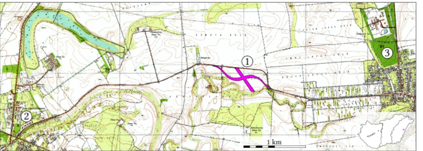
The site is situated on the former northern bank of the Berettyó River, consisting of three prominences and a high flood-free bank(Fig. 1). The area named Papp-zug is under intensive cultivation, the surface of the higher parts is mainly eroded, the lower parts are banked up, and therefore a geomorphological analysis is not possible.
Field survey
A systematic and intensive field survey was performed in the vicinity of Berettyóújfalu in the spring of 2013, which aimed at studying the surroundings of Late Neolithic tell settlements and the Early and Middle Copper Age settlement patterns.1During our fieldwork, we carried out fieldwalking on the area of Berettyóújfalu-Papp-zug. We collected a limited number of findings from several archaeological periods on the elevation situated south of the road between Berettyóújfalu and Szentpéterszeg and northeast of the Herpály mound. A former meander of the Berettyó River surrounded the site from south. Although at the time of the field survey the area was ploughed, the visibility was limited due to the vegetation and the dry surface.
The main goal of the survey was a rough estimation of the extension of sites and to define the spatial distribution of different archaeological periods.
Fig. 1.Location of the investigated archaeological site. 1. Berettyóújfalu-Papp-zug. 2. Berettyóújfalu. 3.
Szentpéterszeg.
We collected the finds in 50×50 meters North-South oriented grids, which corresponds to the EOV (Unified National Projection) coordinate system. We walked along the units in parallel lines, approximately 20 m far from each other. The finds were located with handheld GPS – as precise as 3–5 m – then we evaluated the data in GIS by the number and weight of finds according to periods.
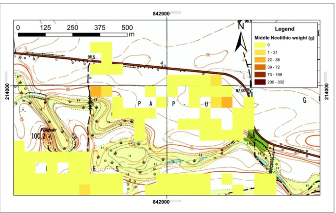
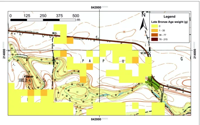
We collected finds dated to the Middle Neolithic (MN), Late Copper Age (LCA), Late Bronze Age (LBA), Sarmatian period and late Migraton period (Avar period and 9th century AD). The finds occurred more densely on two areas, on the West near the way to the Herpály mound, and on the East near the road to Szentpéterszeg, which is the highest point of the area. The distribution of the finds belonging to different periods can be seen on the maps(Fig. 9–13).
1 OTKA PD 101062 “Chronological and spatial relations of Early and Middle Copper Age settlements, cemeteries and metal finds on the Great Hungarian Plain” (PI: Zsuzsanna Siklósi).
224
Preliminary report on the field surveys and excavations in the vicinity of Berettyóújfalu Prior to the excavation a geomagnetic survey had been carried out on the whole road track section. It can only be fully analysed by comparing it with the total map of the unearthed features, on the first raw pictures several anomalies could be corresponded to the excavated ones.
The excavation
The excavations began on the 30th of March and ended on the 31th of August, 2015. After the removal of the thick topsoil layer(Fig. 2)we unearthed a total of 2359 archaeological features.2 The most interesting ones are presented below sorted by periods.
Fig. 2.The excavation surface after the removal of the topsoil layer (Attila Weisz – Salisbury Ltd.)
Middle Neolithic
Middle Neolithic (MN) features could be found at several areas, but the densest concentration situated in an approximately 150 meter wide zone at the western road track(Fig. 14). The most intensive part of the Neolithic settlement could be found directly on the bank of the former Berettyó River. According to the pottery, we can date the settlement to the second half of the MN; we found incised decoration and painted Esztár-style decoration as well. Among the smaller, mainly rounded pits we unearthed large pits(Langsgrube), through which we can identify houseplaces. At the same time we excavated some burials of contracted skeletons without grave goods at the same area that we can most likely connect to the MN settlement.
Beside the large quantity of the usual pottery, animal bones, daub and stone tools, the site provided some more unique finds as anthropomorfic clay statuettes, polished bone tools and stone axes, and a clay rattle with incised decoration. Based on the features there is a good opportunity to locate household units in the future.
2 The staff: Gábor V. Szabó project leader; Dávid Bartus, András Füzesi, Lajos Juhász, László Rupnik, Márton Szilágyi, Gábor Váczi leaders of the excavation; Tamás Czuppon, Kristóf Fülöp, Zita Kis, Csilla Sáró, Nikoletta Sey, Bence Simon, Gábor Tarbay archaeologists; Ádám Békési, Zoltán Berente, László Kolonits, Dóra Máté, Zoltán Medgyesi, Borbála Mohácsi, Nóra Szabó BA archaeologists; Ferenc Benus, Dániel Borza, Huba Lőrincz, Márk Lőrinczy, Máté Mervel, Bence Soós BA students.
225
András Füzesi et al.
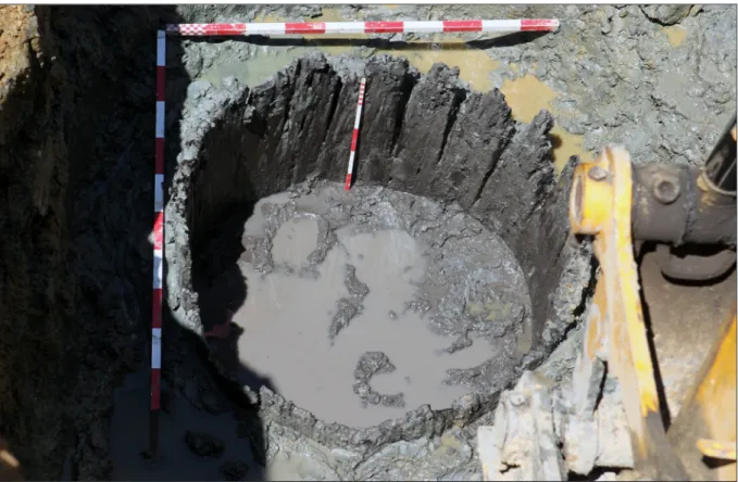
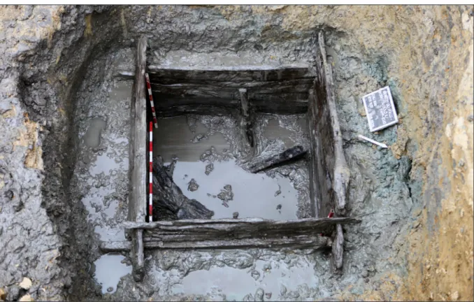
Nevertheless, the most interesting and most significant feature was a well with a tube-like wooden lining (Röhrenbrunnen)situated at the western edge of the settlement(Fig. 3). The astonishingly well-preserved wooden construction appeared at a depth of 5 meters. The well’s shaft had a round diameter and narrowing, straight walls. As opposed to the well from the coeval site of Sajószentpéter-Harmadik vető, the wooden lining was not created by bound panels but from one hollowed trunk with a diameter of 80–90 cm.3The inner surface of the 5–7 cm thick lining was thoroughly elaborate, just as the outer surface, whereon we did not detect any traces of bark.
Fig. 3.Middle Neolithic well with tube-like wooden construction.
The well’s backfill was loose, black-coloured and abundant in organic materials, at some point it was also mixed with greyish and sterile soil. We found a great number of wooden sticks and other wooden fragments together with some bone and stone pieces. Equally, a variety of shards (from large fragments of storage vessels to painted fine ware) came to light. In a small spot of the eastern side of the well a number of bark fragments lay, perhaps belonging to a bucket or some kind of a bag. At every 30 cm we also collected soil samples from the well’s filling for further investigation.
We could only uncover a 140 cm long section of the wooden lining due to the groundwater and the unstable shaft’s walls in a dangerous depth (650 cm), however the wooden structure continued downward.
Due to the wide shaft’s opening (320×290 cm) and its great depth (at least 650 cm) we can presume that the wooden lining did not reach the onetime ground level.
3 Király – Tóth 2013.
226
Preliminary report on the field surveys and excavations in the vicinity of Berettyóújfalu Late Copper Age
The next occupational phase can be dated to the Late Copper Age (LCA) Baden Complex. The features were situated right of the river bank in the western road track, distributed in smaller groups(Fig. 15). It is characteristic that beside the pits with a small amount of finds there were pits almost full of pottery, fine ware, and decorated daub pieces. Based on the pottery the settlement can be dated to the classical Baden period.
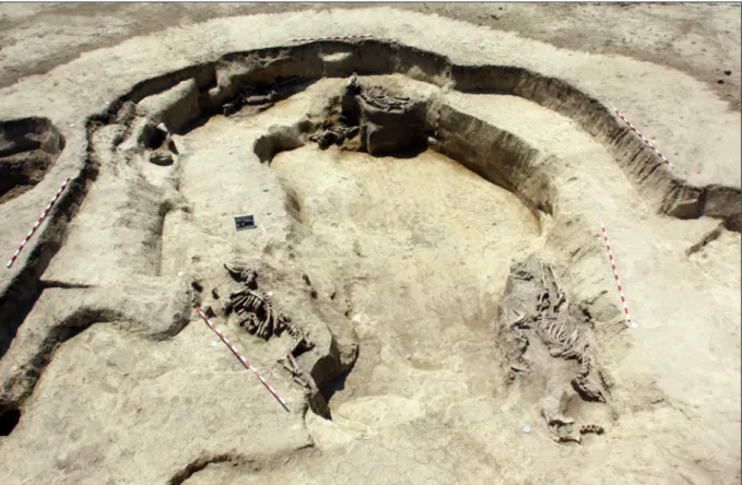
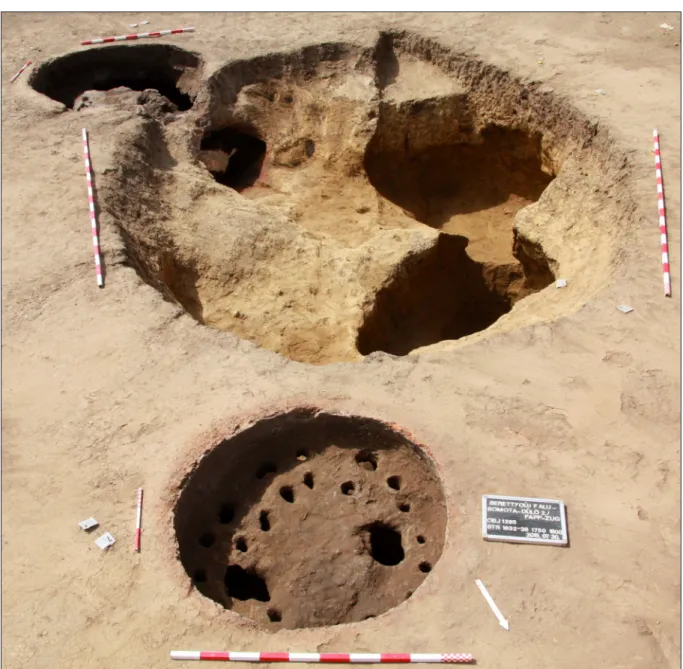
A unique feature of the Baden Complex containing cattle deposits can be found here as well, providing new data on this tradition. In one case we unearthed a rounded pit with a cattle skeleton on its bottom. Under the skeleton a reddish fireplace was observable. Although there were no traces of burning on the bones, due to the stratigrapy we can assume that a relatively short time had elapsed between the act of firing and that of the deposition.
In another case we can assume a place for cattle deposits used for a long period of time. A few meters from the mentioned pit we found a large (8×10 m), irregularly rounded, deep (1.8–2 m) pit.
Its sides were shallower (70–80 cm) and seven cattles had been placed right next to its margin.
Among them we found younger specimens and a partial one(Fig. 4).
Fig. 4.Late Copper Age pit with seven complete cattle skeletons.
According to our present knowledge the cattle deposits are connected to smaller rounded pits, into which one or two cattles are laid.4 These are most likely remnants of a single act.
In the above mentioned case there is a possibility of a longer use of a single space for cattle depositions.
4 Horváth 2012, 119–126.
227
András Füzesi et al.
Late Bronze Age
In the final period of the Late Bronze Age (LBA), within the interval of 1100–850 cal BC (Ha A2–Ha B) the area was inhabited by a population defined as the Gáva culture. The most intensive part of the LBA settlement is situated on the two highest prominences at the central part of the site(Fig. 16). The existence of the LBA storage pits on both the western and the southern ends of the motorway track is a sign of the intentional selection of the higher areas.
The lower areas were only used by the LBA community for maintaining wells.
The most intensive part of the Gáva settlement is characterised by two types of features. The majority of them were mostly regular, rounded pits with flared side and bottom. Most of the garbage (mainly pottery and animal bones) was found on the bottom of the pits as a compact layer, thus the garbage formation and/or deposition seems to be periodical or campaign-like.
The second feature type is of a lower number. The broad extent of these pits reached 18×40 meters, their depth was 1–1.5 meters. The dynamics of their infilling is different from that of the small rounded pits; all layers were filled with finds. Among the great amount of fine ware, cooking and storage pots even a whole horse skeleton was found in one of the pits.
The two largest pits contained remains of metalworking; more than a hundred fragments of bronze objects, fragments of casting moulds and bronze nuggets. There were no traces of buildings; presumably they had been placed onto the free surfaces between the pits. The LBA settlement reveals tight paralels with a nearby Gáva settlement at Biharkeresztes both in respect of structure and find assemblage.5
Fig. 5.Wooden planks of a chest-like construction in a Late Bronze Age well.
5 V. Szabó 2004, 161, Fig. 6.1–11.
228
Preliminary report on the field surveys and excavations in the vicinity of Berettyóújfalu Similarly to other periods, most of the wells were found at the eastern and western margin of the LBA settlement. One of the wells had no traces of lining, while the structure of another well is uncertain due to the small amount of organic remains. However, in the other three wells we found distinct rows of wooden planks of a chest-like construction(Kastenbrunnen). The best preserved one was well no. 830/1037(Fig. 5).6
Its upper part had a round diameter, and its walls narrowed smoothly. At a depth of 140 cm the shape of the shaft changed to rectangular (140×180 cm) and its walls became vertical. The first plank row appeared at the western and northern side of the well at a depth of 320 cm in a mainly decomposed and fragmented condition. Thereafter we excavated further four well-preserved, mostly intact plank rows. The construction of the well corresponds to the technique already known from Bronze and Early Iron Age wells found in Hungary.7 The split and elaborate, large and heavy planks (some of them having a width of 40–50 cm) carved at their both ends and sides were framed by interlocked corner joints. However, during the contsruction the planks turned out to be large and did not fit properly with the size of the shaft. Therefore the onetime makers had to scoop in the shaft’s wall at the corners to enlarge it to stabilize the junction. In spite of this modification the wooden construction did not prove to be steady sufficiently, and the third row of the western side was additionally supported by a 10–15 cm wide wooden pole on the inner and outer side too.
At the level of the second plank row a 4–5 cm thick, gray sand layer appeared. In this layer thin (2–5 cm) branches and sticks lay in an irregular way, maybe as a result of natural contamination.
A large quantity of unevenly chopped and deliberately shapened wooden sticks in different sizes appeared at the level of the fourth row, at a depth of around 400–410 cm, until the bottom of the well. Part of them are very likely debris of the Bronze Age settlement, however, some of them might be interpreted in other ways. The contemporaneous posthole next to the well could be a part of a water hoisting structure, and thus among these wooden sticks and poles we may find the remains of such a structure or perhaps of some well-curb construction.
Late Iron Age
In the Late Iron Age (LIA) only an 80–100 meter wide zone of the former Berettyó bank was inhabited(Fig. 17). The settlement tied strongly to the waterflow, and a continuation in both (Eastern and Western) directions is presumable, but could not be verified by field surveys. The Celtic settlement can be dated to the LaTène C period. The semisubterranean dwellings were placed 8–10 meters from each other, their main orientation was N–S or NE–SW. At the same place, the higher area was densely covered with storage pits.
Sarmatian Period
An intesively inhabited settlement came into existence on the examined area in the Sarmatian Period. A large number of archaeological features dated to the 2nd–4th centuries AD was observable on all of the prominences(Fig. 18). The dating of the settlement features and graves was supported by the coins and fibulae found by metal detector prior to the excavation. On the central parts of the prominences there barely occurred untouched areas among the subterranean
6 The other two wells had only one preserved row, mostly with decomposed end-joining.
7 e. g. Horváth et al. 2004, 211, 4–5. kép; Fülöp 2015; D. Matuz et al. 1998.
229
András Füzesi et al.
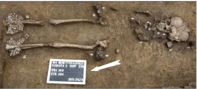
dwellings and storage pits. Nine wells were found at the eastern, most intensive part of the excavated road track. Although there were no traces of wooden structures, we found several limbs, broken wooden spoons and carved sticks in all of them. The burials of this period can be divided into two groups. In the central part of the excavated area a line of seven graves was found, whilst in the eastern side the graves – either rich or poor – occurred dispersedly. The grave line was supplemented by a burial surrounded by a rectangular ditch. Its entrance was situated on the southern side, and a borken vessel was placed in its northeastern corner. The grave goods cannot be considered exceptional, however, the finds (a pair of fibulae, iron knife and glass pearls) were characteristic of the Sarmatian Period(Fig. 6).
Fig. 6.A Sarmatian female burial.
Early Migration Period (Gepids)
A group of Gepids settled down on the northern bank of the river in the Early Migration Period during the 5th century AD. The Sarmatian settlement pattern had been transformed; three main focal areas could be observed(Fig. 19). The prominence at the centre of the road track was inhabited by them as well, but in a smaller area. Leaving a wider empty area they formed two dense settlement clusters directly on the riverside. In the case of the western cluster the semisubterranean dwellings were situated at the lowest parts, which indicates that at that time the water level might have been as low as in the MN and LCA periods. The houses were orientated according to the main points of the compass. Among them and the storage pits only one well was unearthed. No wooden structure could be detected, although interestingly its constantly narrowing pit could be followed 4.7 meters deep. Fragments of pottery and boards were found in its filling. An exceptional feature was found at the central area, a working pit with two lattice ovens. In its backfill numerous organic remains such as charcoal or ash were uncovered. This feature could most likely be connected to pottery-making processes(Fig. 7).
230
Preliminary report on the field surveys and excavations in the vicinity of Berettyóújfalu
Fig. 7.Gepidic working pit with two lattice ovens.
Late Migration Period (Avars)
The last community that settled down on the site can be dated to the Late Avar Period and the 9th century AD. They founded their settlement at the northern bank of the river divided into three clusters(Fig. 20). One of them was situated at the western road track, near the Gepidic settlement, consisting of a group of semisubterranean dwellings and adjacent pits and wells.
The same structure appears at the southern area near the waterflow. However, the features unearthed at the central and northern areas were different. North of the loose group of houses and pits, a livestock enclosure appeared. It was divided into rectangular areas of a size of approximately 80×80 meters. The trenches were orientated according to the main points of the compass; and the orientation of the houses and posthole-structures were oriented by them. It is a characteristic feature that before the cessation of the houses the inside ovens were destroyed and thus the find material was found covering the floor. As a result cooking and frying pots are quite frequent in these features(Fig. 8).
231
András Füzesi et al.
Fig. 8.Late Avar Period house with parts of a destroyed oven.
Summary
Based on this preliminary report one can draw conclusions on how the constantly changing hydrological conditions affected the settling strategies in different periods. We can assume a relatively dry period in the MN and LCA periods since traces of intensive land use can be observed at the lower parts of the site, adjacent directly to the former Berettyó River. The LBA community chose a different strategy; they used the highest areas, and even their wells were placed on the border of the inhabited area, while barely any traces of occupation could be detected at the lower areas. This could be due to a relatively wet period. The LIA community used a narrow but higher zone adjacent to the waterflow, thus we can presume a fluctuation of water level at this time. However, there is no trace of how they used their wider environment.
The Sarmatian population occupied the whole territory, but the most intensive parts of their settlement are not connected directly to the water. Since they used the same areas as the LBA community, we can presume that the hydrological conditions were similar. However, the water level in the 5th century AD could have been the same as in the MN and LCA periods. At the same time, in the Late Avar Period the community living here used the areas near the water, but they had a strategy to use the inner parts of the site.
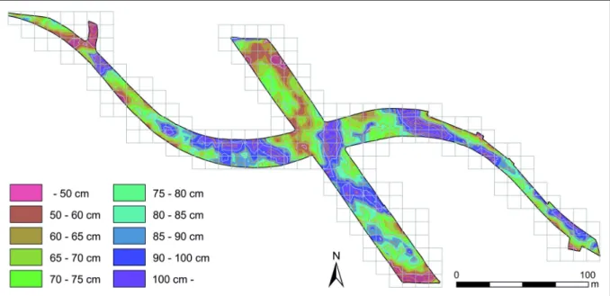
From a methodological point of view we must draw attention to the fact that field surveys do not always correspond to results of excavations, which may have several reasons. First of all densely covered areas resulting from constantly changing hydrological and geomorphological conditions may restrict the opportunity to find archaeological sites. The map showing the topsoil thickness(Fig. 2)corresponds very well to the empty grids of the fieldwalking (Fig.
9–13). It seems that one must pay attention to these limits of field survey even on plain areas.
232
Preliminary report on the field surveys and excavations in the vicinity of Berettyóújfalu However, as a result of a fortunate coincidence, in the future we will be able to build a more complex picture on the Berettyóújfalu-Papp-zug communities from different periods using the results of different research methods.
References
Fülöp, K. 2015:A halomsíros kultúra települése Pusztataskony határában. Az 523. és 637. objektumszámú kutak vizsgálati lehetőségei és szempontjai az őskorban – The settlement of the tumulus culture at the boundry of Pusztataskony. Well no. 523 and 637 – their investigation potential and aspects in prehistory. UnpublishedMA thesis. Budapest.
Horváth, L. A. – Szilas, G. – Endrődi, A. – Horváth, M. A. 2004: Megelőző feltárás Dunakeszi- Székesdűlőn – Preliminary excavation at Dunakeszi-Székesdűlő. In: Nagy, E. Gy. – Dani, J. – Hajdú, Zs. (eds.):MΩMOΣII. Őskoros Kutatók II. Összejövetelének konferenciakötete.Debrecen, 209–218.
Horváth, T. 2012: Animal deposits on the Late Copper Age settlement of Balatonőszöd-Temetői-dűlő, Hungary. In: Pluskowski, A. (ed.):Ritual killing and burial of animals. European perspectives.
Oxford, 115–136.
Király, Á. – Tóth, K. 2013: A Preliminary Report on the Middle Neolithic Well from Sajószentpéter (North-Eastern Hungary).Manuscript. (www.academia.edu/2966913)
D. Matuz, E. – Szabó, J. J. – Vaday, A. 1998: Preszkíta kút Kompolton – Ein präskythischer Brunnen in Kompolt.Communicationes Archaeologicae Hungariae41–62.
V. Szabó, G. 2004: Ház, település és településszerkezet a késő bronzkori (BD, HA, HB periódus) Tisza- vidéken – Houses, Settlements, and Settlement Structures in the Tisza Region of the Late Bronze Age (Periods BD, HA, HB). In: Nagy, E. Gy. – Dani, J. – Hajdú, Zs. (eds): MΩMOΣII. Őskoros Kutatók II. Összejövetelének konferenciakötete.Debrecen, 137–170.
233
András Füzesi et al.
Fig. 9.Weight of Middle Neolithic shards collected by fieldwalking in 2013.
Fig. 10.Weight of Late Copper Age shards collected by fieldwalking in 2013.
234
Preliminary report on the field surveys and excavations in the vicinity of Berettyóújfalu
Fig. 11.Weight of Late Bronze Age shards collected by fieldwalking in 2013.
Fig. 12.Weight of Sarmatian shards collected by fieldwalking in 2013.
235
András Füzesi et al.
Fig. 13.Weight of Avar and 9th century AD shards collected by fieldwalking in 2013.
Fig. 14.Concentration of the Middle Neolithic archaeological features.
236
Preliminary report on the field surveys and excavations in the vicinity of Berettyóújfalu
Fig. 15.Concentration of the Late Copper Age archaeological features.
Fig. 16.Concentration of the Late Bronze Age archaeological features.
237
András Füzesi et al.
Fig. 17.Concentration of the Late Iron Age archaeological features.
Fig. 18. Concentration of the Sarmatian Period archaeological features.
238
Preliminary report on the field surveys and excavations in the vicinity of Berettyóújfalu
Fig. 19.Concentration of the Gepidic archaeological features.
Fig. 20.Concentration of the Avar Period archaeological features.
239