Ser. 3. No. 6. 2018 |
ex Instituto Archaeologico Universitatis de Rolando Eötvös nominatae
DISSERT A TIONES ARCHAEOLO GICAE
Arch Diss 2018 3.6
D IS S E R T A T IO N E S A R C H A E O L O G IC A E
Dissertationes Archaeologicae
ex Instituto Archaeologico
Universitatis de Rolando Eötvös nominatae Ser. 3. No. 6.
Budapest 2018
Dissertationes Archaeologicae ex Instituto Archaeologico Universitatis de Rolando Eötvös nominatae
Ser. 3. No. 6.
Editor-in-chief:
Dávid Bartus Editorial board:
László BartosieWicz László Borhy Zoltán Czajlik
István Feld Gábor Kalla
Pál Raczky Miklós Szabó Tivadar Vida
Technical editor:
Gábor Váczi Proofreading:
ZsóFia KondÉ Szilvia Bartus-Szöllősi
Aviable online at htt p://dissarch.elte.hu Contact: dissarch@btk.elte.hu
© Eötvös Loránd University, Institute of Archaeological Sciences Layout and cover design: Gábor Váczi
Budapest 2018
Contents
Zsolt Mester 9
In memoriam Jacques Tixier (1925–2018)
Articles
Katalin Sebők 13
On the possibilities of interpreting Neolithic pottery – Az újkőkori kerámia értelmezési lehetőségeiről
András Füzesi – Pál Raczky 43
Öcsöd-Kováshalom. Potscape of a Late Neolithic site in the Tisza region
Katalin Sebők – Norbert Faragó 147
Theory into practice: basic connections and stylistic affiliations of the Late Neolithic settlement at Pusztataskony-Ledence 1
Eszter Solnay 179
Early Copper Age Graves from Polgár-Nagy-Kasziba
László Gucsi – Nóra Szabó 217
Examination and possible interpretations of a Middle Bronze Age structured deposition
Kristóf Fülöp 287
Why is it so rare and random to find pyre sites? Two cremation experiments to understand the characteristics of pyre sites and their investigational possibilities
Gábor János Tarbay 313
“Looted Warriors” from Eastern Europe
Péter Mogyorós 361
Pre-Scythian burial in Tiszakürt
Szilvia Joháczi 371
A New Method in the Attribution? Attempts of the Employment of Geometric Morphometrics in the Attribution of Late Archaic Attic Lekythoi
Anita Benes 419 The Roman aqueduct of Brigetio
Lajos Juhász 441
A republican plated denarius from Aquincum
Barbara Hajdu 445
Terra sigillata from the territory of the civil town of Brigetio
Krisztina Hoppál – István Vida – Shinatria Adhityatama – Lu Yahui 461
‘All that glitters is not Roman’. Roman coins discovered in East Java, Indonesia.
A study on new data with an overview on other coins discovered beyond India
Field Reports
Zsolt Mester – Ferenc Cserpák – Norbert Faragó 493
Preliminary report on the excavation at Andornaktálya-Marinka in 2018
Kristóf Fülöp – Denisa M. Lönhardt – Nóra Szabó – Gábor Váczi 499 Preliminary report on the excavation of the site Tiszakürt-Zsilke-tanya
Bence Simon – Szilvia Joháczi – Zita Kis 515
Short report on a rescue excavation of a prehistoric and Árpádian Age site near Tura (Pest County, Hungary)
Zoltán Czajlik – Katalin Novinszki-Groma – László Rupnik – András Bödőcs – et al. 527 Archaeological investigations on the Süttő plateau in 2018
Dávid Bartus – László Borhy – Szilvia Joháczi – Emese Számadó 541 Short report on the excavations in the legionary fortress of Brigetio (2017–2018)
Bence Simon – Szilvia Joháczi 549
Short report on the rescue excavations in the Roman Age Barbaricum near Abony (Pest County, Hungary)
Szabolcs Balázs Nagy 557
Recent excavations at the medieval castle of Bánd
Thesis Abstracts
Rita Jeney 573
Lost Collection from a Lost River: Interpreting Sir Aurel Stein’s “Sarasvatī Tour”
in the History of South Asian Archaeology
István Vida 591
The Chronology of the Marcomannic-Sarmatian wars. The Danubian wars of Marcus Aurelius in the light of numismatics
Zsófia Masek 597
Settlement History of the Middle Tisza Region in the 4th–6th centuries AD.
According to the Evaluation of the Material from Rákóczifalva-Bagi-földek 5–8–8A sites
Alpár Dobos 621
Transformations of the human communities in the eastern part of the Carpathian Basin between the middle of the 5th and 7th century. Row-grave cemeteries in Transylvania, Partium and Banat
DissArch Ser. 3. No. 6. (2018) 549–556. DOI: 10.17204/dissarch.2018.549
Short report on the rescue excavations in the Roman Age Barbaricum near Abony (Pest County, Hungary)
Bence Simon Szilvia Joháczi
Institute of Archaeological Sciences Institute of Archaeological Sciences
Eötvös Loránd University Eötvös Loránd University
simonben.c@gmail.com johi.sziszi@gmail.com
Abstract
The staff of the Institute of Archaeological Sciences of Eötvös Loránd University unearthed a Sarmatian set- tlement and a cemetery near Abony (Pest County, Hungary) in the autumn of 2018. The preliminary results point to the area’s economic importance around the turn of the 2nd–3rd century AD.
Introduction
The staff of the Institute of Archaeological Sciences of Eötvös Loránd University conducted two rescue excavations along the planned M4 motorway between 19th September and 12th October 2018 near Abony (Pest County, Hungary).1 The excavations unearthed thirteen graves of a Sarmatian ring-ditched cemetery and settlement parts on the two sites.
As finalizing the documentation and the restoration of the field material is still an ongoing process, the present report only highlights the most noteworthy features and finds of the ex- cavations. Fortunately, we had the chance to partially excavate a Sarmatian cemetery and a settlement from the same historical period, close to each other.
The environment of the excavations
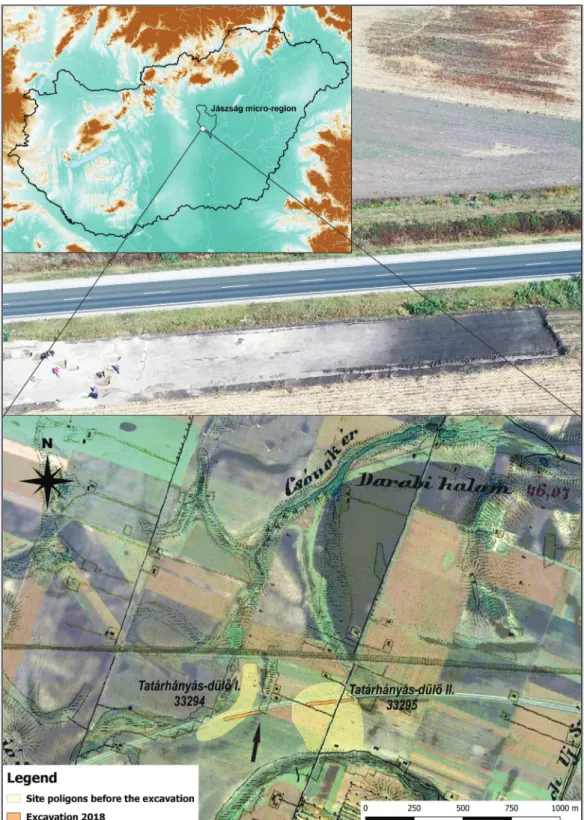
The Roman Age settlement and cemetery are situated in the complex and heterogenous land- scape of the Middle-Tisza District. The sites are north of the present-day city of Abony (Pest County, Hungary) in the Jászság micro-region,2 which can be characterized by small ponds, marshes, narrow and shallow, already up-silted beds of past streams. Both sites are confined by the upper marshy beds of the Málé Stream that is also known as Csónok Stream on the maps of the Second Military Survey.3 The dry banks of the stream were suitable for habitation and to establish a cemetery. During the removing of the top-soil the up-silted beds appeared as dark, 100–120 cm thick layers, and no features were detectable near these sections of the excavations suggesting their existence and power in forming the cultural landscape in the Roman Age (Fig. 1). The environment of the sites shows a dichotomy of rich and productive
1 The excavations were conducted by Bence Simon (ELTE Institute of Archaeological Sciences, Department of Classical and Provincial Archaeology). We hereby say thanks to the staff of the excavations: Anita Benes (PhD student, ELTE), Szilvia Joháczi (PhD student, ELTE), Csilla Sáró (HAS-ELTE Interdisciplinary Research Group of Archaeological Sciences) archaeologists, Ferenc Barna (MA student, ELTE), Tamás Gál (MA stu- dent, ELTE) technicians.
2 Dövényi 2010, 167–170.
3 Col. XXXVI. Sec. 52–53.
550
Bence Simon – Szilvia Joháczi
Chernozem soil and poor meadow-solonec that is mainly suitable for animal grazing.4 This was probably an optimal natural environment for an economy based on both agriculture and animal husbandry, which is a characteristic feature of Sarmatians.5
4 Dövényi 2010, 169. Also on the natural environment of Cegléd and Abony see: Dinnyés 2011, 6–7.
5 Vörös 1998, 63–64.
Fig. 1. Location of the excavations on synchronized Google Earth™ and Second Military Survey maps, with a drone photo of the up-silted channel of the Málé Stream (black arrow showing the direction of the taking).
551 Short report on the rescue excavations in the Roman Age Barbaricum near Abony Th ere are only a few traces of historic human landscape forming in the area. Interestingly the Hungarian name of the fi eld (Tatárhányás), where the sites are located, points to burial mounds. Based on this observation, it seems possible that tumuli were erected above some of the Sarmatian graves, which were recognizable until the last few centuries.6
Tatárhányás-dűlő I – settlement (Fig. 2)
Th e site was identifi ed by István Dinnyés in 2002 on a fi eld-walking in connection with the preparation of the preliminary archaeological documentation for the construction of the new section of Highway 4, which was to by-pass Abony from the north. In 2003 he conduct- ed a rescue excavation on the site during which he opened 2956 m2. Th ey unearthed ditches and pits, altogether 79 archaeological features that could be dated to the 2nd–3rd century AD.7 In 2007 Róbert Kalácska excavated the site.
Th e Institute of Archaeological Sciences of Eötvös Loránd University conducted the large- scale excavation on 2814 m2 as subcontractor of the Ferenczy Museum Center on commis- sion of the Budavári Estate Development and Operation Offi ce between 26th September 2018 and 12th October 2018. During the campaign 67 features were identifi ed, which proved to belong to a Sarmatian sett lement, as it had been previously expected. Th e top-soil removal was conducted from the eastern side of the track where a 25 m wide strip of black humus appeared as mentioned above (Fig. 1, photo). Th e yellowish subsoil was at 40–45 cm below surface where the features of the sett lement appeared. 35 meters from the western side of the opened area, the top-soil became dark and thick again in which no features were found.
Still in this black humus, right next to the north-western corner, some sett lement features were also unearthed, but it was hard to tell their fi lling and the humus apart. We found no trace that the agricultural cultivation had damaged the archaeological features.
Sarmatian sett lement features, which were decisively beehive-shaped pits, appeared in four groups on the excavation. Th e eastern group was terminated by a ditch from the east, where three large pit-complexes were unearthed. It was not possible to determine whether they were originally formed as a whole or they have been expanded over time. Th eir fi lling con-
6 Dinnyés 2011, 7.
7 Dinnyés et al. 2004.
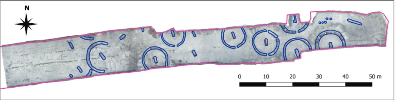
Fig. 2. Map of the Sarmatian settlement in Tatárhányás-dűlő I (33294).
552
Bence Simon – Szilvia Joháczi tained a variety of archaeological fi nds,
pott ery and animal bones. From one of these complexes a terra sigillata bowl came to light which can be dated to the late Severan Age.8 Many pits were situat- ed in their environment, which produced the same type of material. Th is group was confi ned by a north-south-orient- ed ditch, which did not cross the whole opened area. Besides this a sallow ditch of an uncertain age and diff erent fi lling ran in the middle of the track.
Th e features of the second group can be found aft er another 20 meters to the west. Th is section is dominated by round, smaller, but more densely grouping pits
(Fig. 3). Besides them a pit was located on the southern side of the excavation, which was extended with a compartment on one side. Th is could have been used as a pen for domestic animals or as a storage facility.9 Between the pits a west-east running ditch was unearthed, and sherds of a large vessel were collected from its fi lling.
Ten meters to the west, among round pits, a smoker/dryer facility was uncovered with its two beehive-shaped pits connected with a red burnt fl ue. Th e adjacent round pit’s slag also att ests to the everyday production of the sett lement. Next to these features the deepest and largest pit of the excavation was situated. From its fi lling a bone skate and pieces of a Drag.
37 form terra sigillata bowl were found.
At the western end of the excavated track, features of a similar smoker/dryer facility were uncovered as described above. A pear-shaped oven and its working pit was also found in this group. Th e wall and the cooktop of the oven was so severely ruined that its original form was hardly recognizable. We fi rst believed it to be a smoker, but no pit appeared to the south.
8 Drag. 37 form bowl from Rheinzabern, product of Mammilianus. I hereby say thanks to Barbara Hajdú (BHM, Aquincum Museum) for her help in the identifi cation of the vessel.
9 Cf. Vörös 1998, 61, Fig. 10. a.
Fig. 3. Th e excavation of the sett lement from the air.
Fig. 4. Map of the Sarmatian cemetery in Tatárhányás-dűlő II (33295).
553 Short report on the rescue excavations in the Roman Age Barbaricum near Abony
None of the excavated features could be defined as a dwelling. Not only the fea- tures, but the find material seemed to be industrial and household waste which is underlined by the animal bones, coarse and wheeled fine pottery ware, import- ed terra sigillata and on one occasion the slack and the bone skate. Based on the ma- terial the site is dated to the 2nd–3rd cen- tury, which corresponds to the results of past excavations.
Tatárhányás-dűlő II – cemetery (Fig. 4)
The site was also identified by István Din- nyés in 2002 on the same field-walking campaign that I have mentioned above.
He also had the chance to lead an exca- vation on the site in 2003 opening a 7883 m2 surface, during which a 2nd–3rd century Sarmatian cemetery and a few settlement features were unearthed.10 In 2004 part of the site was opened with the same re- sults,11 therefore the same was expected of this year’s campaign.
We performed the large-scale excavation between 19th September 2018 and 2nd Oc- tober 2018 opening a 250-meter-long area of 3122 m2 to the south of Highway 4, as a result of which we identified 49 fea- tures. The planned track was divided by a north-south running agricultural dirt- road. The eastern side in accordance with this, produced only one pit of an uncertain age. This can be explained by the thick (100 cm) dark earthen layers of the up-silted channel of the Málé Stream mentioned above. We proceeded with the removal of the top-soil from the east to the west. The archaeological features appeared in the yellow subsoil around 40–45 cm below surface on the dirt-road’s western side.
10 Dinnyés et al. 2004.
11 Gulyás 2005. The publication of the excavations: Gulyás 2011.
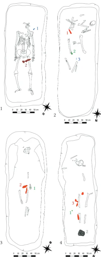
Fig. 5. Abony-Tatárhányás-dűlő II (33295). 1 – male grave with: 1 – iron fibula, 2 – iron object (knife or buckle?), 2 – male grave with: 1 – iron knife, 2 – bronze belt buckle, 3 – bronze garment acces- sory, 3 – grave of a child with: 1 – bronze bracelet, 2 – iron objects (one knife), 4 –grave of a child with:
1 – Roman coin, 2 – pottery vessel, 3 – iron objects.
1
2
3 4
554
Bence Simon – Szilvia Joháczi
In this section, after 20 meters to the west, the chain of the ring-ditched graves lined up until they ceased 30 meters before the western borders of the opened area. The cemetery surely extends farther to the south.
We identified 13 graves, of which 8 were terminated by a ring-ditch. The orientation of the graves was identically south–south-east, and an entrance on the ring-ditch also faced this direction. The graves of the cemetery were perturbed or robbed not later than a few hundred years after the burial. We managed to unearth articulated remains only in one case, although the deceased’s skull was missing (Fig. 5.1). Despite of their disturbance, the way of the dispo- sition could be determined. The deceased were laid on their backs with their skulls directed to the south.
Based on the find material, mainly beads, four graves contained remains of women. From one of these graves a duck-shaped brooch was also uncovered. We unearthed six male burials in which knives and other iron objects were common. We can list an iron brooch, a bronze fibula with folded foot, and a bronze and iron belt buckle among the garment ac- cessories (Fig. 5.2). Two graves belonged to juveniles. One deceased wore bronze bracelets on the arms and was furnished with some iron objects (Fig. 5.3), while the other contained a silver coin in bad condition, also iron objects and a pottery vessel at the feet (Fig. 5.4).
Curiously, not only the juvenile, but two other graves contained coins too. Unfortunately, we cannot tell the date of their minting before restora-
tion. Next to the graves on the western section of the excavation, six features, a ditch and five smaller pits were unearthed without any significant material.
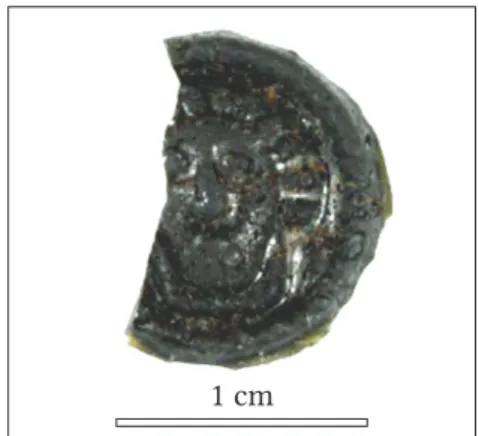
The cemetery coincides with the results of István Dinnyés and Gyöngyi Gulyás, as we found a Drag. 37 form terra sigillata bowl originating from the factory of Pfaffenhofen in one of the ring-ditches,12 and also a small round glass plate depicting the head of a woman from a Sarmatian woman’s grave. The object is definitely of Roman origin, and it best resembles the hair-styles of Faustina Minor or Iulia Domna, maybe dating it from Marcus Aurelius to the late Severan Age (Fig. 6).13
Historical and topographic background
Based on the imported Roman pottery the settlement and the cemetery could be dated to the last quarter of the 2nd and the first quarter of the 3rd century AD. This period coincides with the era when Roman and Barbarian economic relations became tighter and the export of Roman pottery was at its peak.14 The colony of Aquincum was one of the main hubs in this trading network. Many of the trading routes started here to cross the Barbaricum from Pannonia to
12 We found vessels in two ring-ditches and both were in the northern part of the ditch, suggesting their ritual burial. Cf. Gulyás 2011, 139.
13 I hereby say thanks for the opinion of Dávid Bartus (ELTE Institute of Archaeological Sciences) and István Vida (HNM Coin Cabinet Department).
14 Gabler 2011a, 49, Tab. 7, 2.
1 cm
Fig. 6. Abony-Tatárhányás-dűlő II (33295). Imported Roman glass plate from a female grave.
555 Short report on the rescue excavations in the Roman Age Barbaricum near Abony the province of Dacia. The epigraphic evidence also highlights the importance of the city, near which beneficiarii consulares were out-posted to control the border traffic.15 The provincial governor’s office also employed an interprex Sarmatarum16 and an interprex Germanorum,17 who were engaged in commercial and political state affairs with the barbarian tribes neigh- bouring the frontiers of Pannonia.18
One of the main trading routes ran close to the settlement and cemetery excavated during the autumn campaign (Fig. 7). This road started somewhere near the late Roman fort of Contra Aquincum (Március 15-e Square, Budapest) and it was running south-east towards the cross- ing on the Tisza River near Szolnok. Roman buildings, probably road stations are supposed to be situated in Üllő and near Szolnok19 which assisted the Roman traffic in the Barbaricum.
Along the road many Sarmatian sites were excavated,20 which produced many imported Ro- man material also pointing to its importance in the late 2nd–3rd century.21 In this context, the Roman import material from the excavated area is not surprising and underlines the Severan Age Sarmatian settlements’ economic importance near Abony and Cegléd.
15 Gabler 2011a, 44.
16 CIL III, 14349,05. = Epigraphik-Datenbank Clauss/Slaby ID (http://db.edcs.eu/epigr/epi.php?s_sprache=en):
EDCS-32400042
17 CIL III, 10505. = Epigraphik-Datenbank Clauss/Slaby ID (http://db.edcs.eu/epigr/epi.php?s_sprache=en):
EDCS-29500182 18 Mairs 2012.
19 Vaday 1998, 124.
20 From the past excavations near Abony and Cegléd the terra sigillata material was published (Gabler 2011b).
21 Gabler 2011a, 47.
Fig. 7. Position of the excavations in the Roman Era Barbaricum (Map based on Gabler 2011a, 3. Tábla).
556
Bence Simon – Szilvia Joháczi
Catalogues
CIL: Corpus Inscriptionum Latinarum
References
Dinnyés, I. – Gulyás, Gy. – Madaras, L. 2004: Abony, Tatárhányás-dűlő. In: Kisfaludi J. (ed.):
Régészeti kutatások Magyarországon 2003. Budapest, 153.
Dinnyés, I. 2011: Megelőző feltárások Abony és Cegléd térségében 2002–2006 között. Előzmények, lebonyolítás. Studia Comitatensia 31, 6–19.
Dövényi, Z. (ed.) 2010: Magyarország kistájainak katasztere. Budapest.
Gabler, D. 2011a: Utak Pannonia és Dácia között a “Barbaricumon” át. Dolgozatok az Erdélyi Múzeum Érem és Régiségtárából. Új Sorozat III–IV, (2008–2010) 43–54.
Gabler, D. 2011b: Terra sigillaták Cegléd és Abony határából. Studia Comitatensia 31, 254–284.
Gulyás, Gy. 2005: Abony, Tatárhányás-dűlő. In: Kisfaludi J. (ed.): Régészeti kutatások Magyarországon 2004 – Archaeological Investigatons in Hungary 2004. Budapest, 164.
Gulyás, Gy. 2011: Szarmata temetkezések Abony és Cegléd környékén. Studia Comitatensia 31, 125–253.
Mairs, R. 2012: ’Interpreting’ at Vindolanda: Commercial and Linguistic Mediation in the Roman Army. Britannia 43, 17–28.
Vaday, A. 1998: Kereskedelem és gazdasági kapcsolatok a szarmaták és a rómaiak között. In: Vaday, A.
(ed.): Jazigok, roxolánok, alánok. Szarmaták az Alföldön. Gyulai Katalógusok 6. Gyula, 117–144.
Vörös, G. 1998: Településszerkezet és életmód az alföldi szarmaták falvaiban. In: Vaday, A. (ed.):
Jazigok, roxolánok, alánok. Szarmaták az Alföldön. Gyulai Katalógusok 6. Gyula, 49–66.