Dissertationes Archaeologicae
ex Instituto Archaeologico
Universitatis de Rolando Eötvös nominatae Ser. 3. No. 2.
Budapest 2014
Dissertationes Archaeologicae ex Instituto Archaeologico Universitatis de Rolando Eötvös nominatae
Ser. 3. No. 2.
Editor-in-chief:
Dávid Bartus Editorial board:
László Bartosiewicz László Borhy
István Feld Gábor Kalla
Pál Raczky Miklós Szabó Tivadar Vida Technical editors:
Dávid Bartus Gábor Váczi András Bödőcs
Dániel Szabó Proofreading:
Szilvia Szöllősi
Available online at http://dissarch.elte.hu Contact: dissarch@btk.elte.hu
© Eötvös Loránd University, Institute of Archaeological Sciences Budapest 2014
Contents
Selected papers of the XI . Hungarian Conference on Classical Studies
Ferenc Barna 9
Venus mit Waffen. Die Darstellungen und die Rolle der Göttin in der Münzpropaganda der Zeit der Soldatenkaiser (235–284 n. Chr.)
Dénes Gabler 45
A belső vámok szerepe a rajnai és a dunai provinciák importált kerámiaspektrumában
Lajos Mathédesz 67
Római bélyeges téglák a komáromi Duna Menti Múzeum yűjteményében
Katalin Ottományi 97
Újabb római vicusok Aquincum territoriumán
Eszter Süvegh 143
Hellenistic grotesque terracotta figurines. Problems of iconographical interpretation
András Szabó 157
Some notes on the rings with sacred inscriptions from Pannonia
István Vida 171
The coinage of Flavia Maxima Helena
Articles
Gábor Tarbay 179
Late Bronze Age depot from the foothills of the Pilis Mountains
Csilla Sáró 299
Roman brooches from Paks-Gyapa – Rosti-puszta
András Bödőcs – Gábor Kovács – Krisztián Anderkó 321
The impact of the roman agriculture on the territory of Savaria
Lajos Juhász 333
Two new Roman bronzes with Suebian nodus from Brigetio
Field reports
Zsolt Mester – Norbert Faragó – Attila Király 351
The first in situ Old Stone Age assemblage from the Rába Valley, Northwestern Hungary
Pál Raczky – Alexandra Anders – Norbert Faragó – Gábor Márkus 363 Short report on the 2014 excavations at Polgár-Csőszhalom
Daniel Neumann – Zsuzsanna Siklósi – Roman Scholz – Márton Szilágyi 377 Preliminary Report on the first season of fieldwork in Berettyóújfalu-Szilhalom
Márton Szilágyi – András Füzesi – Attila Virág – Mihály Gasparik 405 A Palaeolithic mammoth bone deposit and a Late Copper Age Baden settlement and enclosure
Preliminary report on the rescue excavation at Szurdokpüspöki – Hosszú-dűlő II–III. (M21 site No. 6–7)
Kristóf Fülöp – Gábor Váczi 413
Preliminary report on the excavation of a new Late Bronze Age cemetery from Jobbáyi (North Hungary)
Lőrinc Timár – Zoltán Czajlik – András Bödőcs – Sándor Puszta 423 Geophysical prospection on the Pâture du Couvent (Bibracte, France). The campaign of 2014
Dávid Bartus – László Borhy – Gabriella Delbó – Emese Számadó 431 Short report on the excavations in the civil town of Brigetio (Szőny-Vásártér) in 2014
Dávid Bartus – László Borhy – Emese Számadó 437
A new Roman bath in the canabae of Brigetio
Short report on the excavations at the site Szőny-Dunapart in 2014 Dávid Bartus – László Borhy – Zoltán Czajlik – Balázs Holl –
Sándor Puszta – László Rupnik 451
Topographical research in the canabae of Brigetio in 2014
Zoltán Czajlik – Sándor Berecki – László Rupnik 459
Aerial Geoarchaeological Survey in the Valleys of the Mureş and Arieş Rivers (2009-2013)
Maxim Mordovin 485
Short report on the excavations in 2014 of the Department of Hungarian Medieval and Early Modern Archaeoloy (Eötvös Loránd University, Budapest)
Excavations at Castles Čabraď and Drégely, and at the Pauline Friary at Sáska
Thesis Abstracts
Piroska Csengeri 501
Late groups of the Alföld Linear Pottery culture in north-eastern Hungary New results of the research in Borsod-Abaúj-Zemplén County
Ádám Bíró 519
Weapons in the 10–11th century Carpathian Basin
Studies in weapon technoloy and methodoloy – rigid bow applications and southern import swords in the archaeological material
Márta Daróczi-Szabó 541
Animal remains from the mid 12th–13th century (Árpád Period) village of Kána, Hungary
Károly Belényesy 549
A 15th–16th century cannon foundry workshop in Buda
Craftsmen and technoloy of cannon moulding and the transformation of military technoloy from the Renaissance to the Post Medieval Period
István Ringer 561 Manorial and urban manufactories in the 17th century in Sárospatak
Bibliography
László Borhy 565
Bibliography of the excavations in Brigetio (1992–2014)
Short report on the 2014 excavations at Polgár-Csőszhalom
Pál Raczky Alexandra Anders
Institute of Archaeological Sciences Institute of Archaeological Sciences
Eötvös Loránd University Eötvös Loránd University
raczky.pal@btk.elte.hu anders.alexandra@btk.elte.hu
Norbert Faragó Gábor Márkus
Institute of Archaeological Sciences
Eötvös Loránd University Archeodata 1998 Ltd.
norbert.farago@gmail.com markusgabor@yahoo.com
Abstract
On the basis of the archaeological data gained from the Polgár-Csőszhalom site the space/time configura- tion and the relevant interpretative evaluations have reached a certain “historical” perspective and a pecu- liar “evolution” during the last 25 years. The development of the different analytical methods from time to time enabled the creation of increasingly fine-grained reference systems as well as new scales for a histori - cal narrative. Fundamentally new information was provided by a new magnetometer prospection carried out in 2013. First of all it is clear that the extent of the settlement reached beyond the previously recon- structed borders. The preliminary analysis of the measurements resulted in another double enclosure system west of the main tell-enclosure structure. An archaeological test trench exposed the details of this macro- construction in 2014. Altogether this means that the interactions between people, things and places may have been much more sophisticated in the vicinity of the Csőszhalom settlement complex than thought be- fore. All these details could demonstrate that the geophysical prospection cannot provide a clean-cut map about the Neolithic features of the Polgár site, and therefore we are not able to use the relevant data auto- matically without further consideration.
Research history of the site
I. The research history of Polgár-Csőszhalom began with a very symbolic act in 1929 when V.
Gordon Childe registered the site as Polgár on a European site distribution map of the Danu- bien II civilizations.1 Furthermore he also identified the “Polgár-culture” and considered it having the closest connection with the Lengyel–Jordansmühl cultural entity. He argued that the distinct feature of the group represented by Polgár was the use of ceramic decoration ar- ranged into vertical panels where the red and white colours were applied after firing. This type of “crusted ware” became a characteristic feature of the Polgár pottery style.2 Despite of the published textual data about the Polgár site, there was not even an illustration of the dis- cussed material. In connection to Polgár V. Gordon Childe also drew attention to the obsid- ian, the very special lithic raw material which originated from Northern Hungary and was distributed in Moravia as well as in the Tisza region.
1 1 Childe 1929, Map III.
1 2 Childe 1929, 76–81.
DissArch Ser. 3. No. 2 (2014) 363–375.
P. Raczky – A. Anders – N. Faragó – G. Márkus: Short report on the 2014 excavations at Polgár-Csőszhalom
Ferenc Tompa, an outstanding Hungarian archaeologist also made contributed greatly to the study of the Polgár-Csőszhalom site in 1929, however the name of the village where the mound was located was officially used in the form as Tiszapolgár for a short time period.
This was the reason why the labels Polgár and Tiszapolgár have periodically appeared in- consequently in the archaeological literature. Ferenc Tompa published the first real exam- ples of the characteristic painted pottery from a local private collection and he pointed out the tell character of Tisza culture settlements for the first time. Tompa considered it funda- mental that the Polgár painted style in fact was a representative of the Tisza II phase distrib- uted generally across the Great Hungarian Plain.3
II. In 1957 Ida Bognár-Kutzián sunk a test trench sized 12 by 2 m in the south-eastern part of the Csőszhalom mound. At the same time this was the first systematic archaeological activ- ity in the locality. The very restricted area of investigations at the site exposed five succes - sive occupation levels and the habitation strata accumulated to 3.5 m. These results clearly supported the idea that the Csőszhalom mound could represent the northernmost Neolithic tell settlement type in Southeast Europe.4 On the basis of the excavation the terminology of the “Csőszhalom group” was introduced into the scolarly discourse by Bognár-Kutzián and she presented a selection of nine vessels on a plate illustrating the material meaning of this cultural phenomenon.5 In a wider perspective the Tisza–Herpály–Csőszhalom cultural unit was considered the representative of the Late Neolithic in the Great Hungarian Plain.6 The final report of this early investigation with the detailed summary of research history eventu- ally appeared in 2007.7
III. Archaeological interest in the Polgár-Csőszhalom site was to a large extent inspired by its unique location in the Upper Tisza Region approximately 100 km north of the main con- centration of the Late Neolithic tell-settlements in the Great Hungarian Plain.8 A new inves- tigation program began in 1989 with the support of the Museum für Vor- und Frühgeschichte (Frankfurt am Main), the Déri Museum (Debrecen) and the Archaeological Institute of the Eötvös Loránd University (ELTE). The first surprising result of the aerial photography sur- vey was the traces of an enclosure system around the tell settlement.9 The Geophysical De- partment of the ELTE organised a systematic geophysical survey on the Csőszhalom mound and the investigations led by Balázs Székely and Sándor Puszta outlined a fivefold concentric earthenwork around a central elevation under the surface.10 The complex structure appeared to have a 180 to 190 m outer diameter, while the internal section could be calculated for 70 to 75 m. The magnetometer surveys mapped four entrances to this rondel. Burned house re- mains were also detected over an area of 40 m diameter in the central part of the tell. The geo- magnetic measurements were also complemented by test borings arranged in the lines of the four cardinal directions in 1989 and 1991. With the help of stratigraphic data from subsur- face probing Gábor Rózsa and András Varga presented a 3D approximation of the inner structure of the enclosure complex at Csőszhalom.11 On the grounds of the comprehensive
1 3 Tompa 1929, Pl. LIV: 2, Pl. LV–LVII; Tompa 1937, 47.
1 4 B. Kutzián 1958.
1 5 Bognár-Kutzián 1966, Abb. 7. 1–9.
1 6 Bognár-Kutzián 1966, 268–269.
1 7 Bánffy – Bognár-Kutzián 2007.
1 8 Makkay 1982; Kalicz – Raczky 1987.
1 9 Raczky et al. 1994, Pl. V.
1 10 Raczky et al. 1994, Pl. VI; Raczky 1995, Fig. 2.
1 11 Raczky et al. 1997a, Fig. 7.
364
P. Raczky – A. Anders – N. Faragó – G. Márkus: Short report on the 2014 excavations at Polgár-Csőszhalom
geoarchaeological research we opened our trenches (I–IV). These were aimed at providing a representative picture of the Csőszhalom mound.
The results of successive campaigns conducted between 1989 and 1993 suggested that the Csőszhalom site enclosed by a multiple ditch-palisade system cannot be regarded a settle- ment resembling the Neolithic tells in the Balkans. We argued that Polgár-Csőszhalom, with the structural unity of the stratified mound and the enclosure system, represents a spatial symbiosis of the Tisza–Herpály as well as Lengyel types of monumental landmarks. Fur- thermore we tried to interpret the entity of the tell-enclosure structure as a “central place”12 in accordance with the early ideas of Hermann Parzinger.13
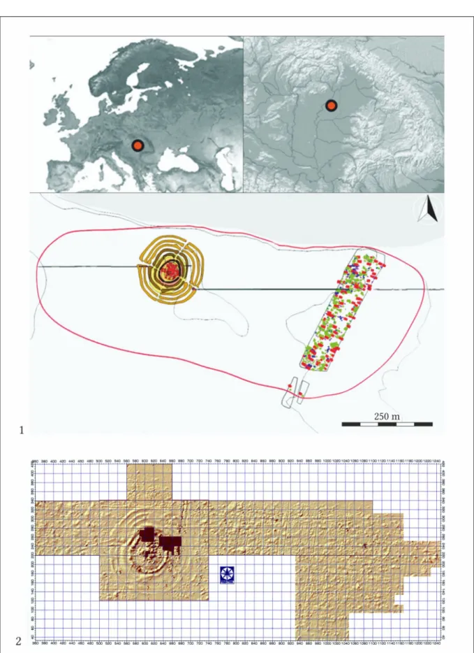
IV. In a following research phase micro-regional investigations were conducted in the Polgár area as part of the rescue project preceding the construction of the M3 motorway. An ap- proximately 700 × 400 m large horizontal settlement was estimated in the close proximity of the Csőszhalom mound in 1994. In accordance with the preliminary conclusions, it became evident, that the tell and the newly identified single layer settlement formed an organic functional unit and those historical reconstruction could only be based on a joint space/time evaluation.14 In terms of its verified 28 ha size the Polgár settlement is a unique phenome- non in the Late Neolithic in the Great Hungarian Plain.
During this phase we tried to outline the precise horizontal extent of the settlement com- plex. In accordance with this effort aerial photographs were taken by Otto Braasch within the same program in 1993 and 1994 and some new macro-morphological details became vis- ible around the site of Polgár Csőszhalom.15 In this research program we sought after the in- tegrated application of aerial photography and magnetometer surveys using GIS processing.
New magnetometer surveys by the personal implementation of Sándor Puszta revealed a map of the highly aggregated features of the horizontal settlement, however no special ar- chitectural details were visible at the technical level applied.16 The archaeomagnetic survey was conducted with a proton magnetometer of 0.1 nT/m sensitivity and the surveyed area was covered by a 1 × 1 m grid (Fig. 1.2).
In the reconstruction of the Polgár-Csőszhalom settlement complex we tried to integrate different types of archaeometric data compiled a synthetic map of the topographic micro setting of the site.17 In 1996 we opened a trench (trench V) for the attesting of the north- eastern gate of the Csőszhalom enclosure system.
An approximately 400 m long and 90–100 wide north to south section could be recovered from the horizontal settlement of the Polgár-Csőszhalom site during the rescue program of the M3 motorway between 1995 and 2004.
V. In 2006 we received the consent of local landowners for making a mechanized east–west sounding trench through the site thus providing a cross section in a 1000 × 1 m dimension.
Taking into consideration the results of this project we gained new spatial information con- cerning to the horizontal distribution of the Polgár settlement. In accordance with new field
1 12 Raczky et al. 1994, 234; Raczky 1995, 84–82.
1 13 Parzinger 1992.
1 14 Raczky et al. 1997b.
1 15 Raczky et al. 2002, Fig. 5–6.
1 16 Raczky et al. 2002, Fig. 7.
1 17 Raczky et al. 1997b, Fig. 21–22; Raczky et al. 2002, Fig. 8.
365
P. Raczky – A. Anders – N. Faragó – G. Márkus: Short report on the 2014 excavations at Polgár-Csőszhalom
research we had to modify estimations concerning the horizontal extension of the site com- plex to 38 hectares. A new topographic map was published based on a combination of mag- netometric surveys, field walks and excavations (Fig. 1.1).18 During this research period we delivered a very detailed analysis concerning the loci of activity and spatial configuration of the Polgár settlement complex.19
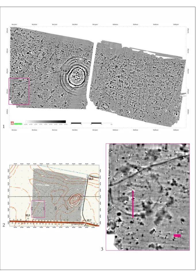
VI. In 2013 Gábor Márkus carried out a new type of geophysical survey using the vehicle towed MAGNETO®MX system with a 0.1 nT/m resolution. The multisensor-system in this case contained eight sensors and the distance between the sensors was exactly 0.25 m. The magnetometer survey covered an approximately 33 hectares surface and this project pro- vided very important new details about the spatial affiliations of the horizontal settlement (Fig. 2.1, 5.1). Among others, new geophysical research identified a second enclosure 200 m west of the main tell-enclosure (Fig. 2.2–3), which means a new starting point for the recon- struction of coeval features and activity areas inside the late Neolithic settlement-complex.
Furthermore this methodology, applied on wider scale, could contribute to a new research standard used for the analysis of settlement patterns in European archaeology.20
The newly gained magnetometer map also posed a scientific challenge in the archaeological identification of the features detected. Therefore a very restricted field program was orga- nized in 2014.
Fieldwork in 2014
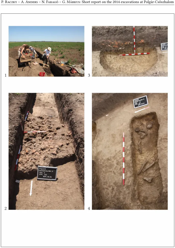
1. The second enclosure identified by geophysical research has two concentric ditches. The diameter of the inner circle is approximately 40 m, and the outer is approximately 60 m. In August we opened a 1 m wide and 32 m long trench, oriented north to south cutting through the anomalies of the supposed ditches (Fig. 2.3). Removing the first 20 cm of the humus layer we divided the trench into 1 × 1 m quadrates and continued working in these sections until the level of prehistoric features which first appeared around a depth of 80 cm. We deepened the excavation squares by 20 cm. The soil was dry sieved and the finds of these units are kept un- der separated stratigraphic numbers (Fig. 3.1).21 The main archaeological features recovered were as follows:
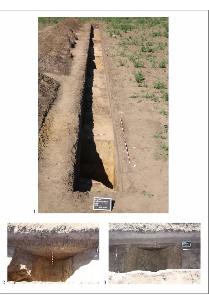
• Detail of the outer ditch (Feature 1). The V-shaped section of the ditch is 200 cm wide on the top and it narrows down to 40 cm in the bottom at the depth of 195 cm (Fig. 4.1–2).
• Detail of the inner ditch (Feature 2). The V-shaped section of the ditch is 210–
180 cm wide on the top and it narrows down to 25–40 cm in the bottom at the depth of 180 cm (Fig. 4.1, 3). The northern section of the ditch’s wall narrows step by step.
• Detail of an oval shaped pit (Feature 6): We were able to detect the pit directly above the plough zone. The fill of the pit contained quantities of daub, shards and lithics (Fig. 3.2–3).
1 18 Raczky – Anders 2010, Fig. 2; Raczky et al. 2011, Fig. 2.
1 19 Raczky – Anders 2010; Raczky et al. 2011.
1 20 E.g.: Chapman et al. 2014; Rassmann et al 2014.
1 21 This method was used also during the excavation of Polgár-Bosnyákdomb: Raczky – Anders 2009.
366
P. Raczky – A. Anders – N. Faragó – G. Márkus: Short report on the 2014 excavations at Polgár-Csőszhalom
• Grave (Feature 5). The deceased lay in a rounded oblong-shaped pit on his/her left side, in a slightly contracted position. The skeleton was poorly preserved.
Two small vessels have been found near the skull as grave goods (Fig. 3.3).
In addition to these features a pit section (Feature 3) and a detail of a narrow ditch (Feature 4) were explored. With the exception of Feature 3 (probably Iron Age?) all features could be se- curely dated to the Late Neolithic.
2. Some 50 m southeast of the second enclosure geophysical research identified well-struc- tured anomalies, which seemed to be the structural details (posts) of a building of unusual sizes (Fig. 2.3). We opened a verifying trench over the north-eastern corner of the aforemen- tioned structure (measurig 8 × 4 m) in October. Ten postholes were unearthed at this place.
They belonged to different architectural constructions whose orientations were indicated an approximately east-west as well as a north-south direction (Fig. 5.2). Some of the postholes contained intensively burnt pieces of daub (Fig. 5.3). On the other hand some postholes showed no sign of burning, but remains of vertically split trunks (Fig. 5.4). We argue that all of the excavated features could be dated to the Late Neolithic period.
During our test excavation different samples were taken for radiocarbon dating, as well as the analysis of sedimentols, plant macro-remains and soil micro-morphology. These pro- vided precise details of the excavated contexts.
Conclusions
On the basis of the archaeological data gained from the Polgár-Csőszhalom site the space/time configuration and the relevant interpretative evaluations have reached a certain
“historical” perspective and a peculiar “evolution” during the last 25 years. It is a fundamen- tal experience that understanding a site obviously is a never ending process. The interdisci- plinary methods applied in different phases of research have regularly opened new archaeo- logical aspects of settlement study and stimulated new questions concerning previous archaeological approaches. Furthermore the development of different analytical methods from time to time enabled the creation of increasingly fine-grained reference systems as well as new scales for historical narrative. As a result of the aforementioned dialectic rela- tionship, archaeological models repeatedly provoked new questions to be answered.22
1. Through the integrated application of aerial photography and geophysical prospection it became clear that Polgár-Csőszhalom was surrounded by a system of concentric ditches and palisades. It has also been suggested that the site represented a special cultural symbiosis between the tell and the enclosure-palisade structures. This hypothesis was also supported by the excavations. In the physical relationships between the stratified mound and the hori- zontal settlement at Polgár very expressive dichotomy appeared between the different space/time attitudes of the human actors.
2. The horizontal extent of the settlement complex at Polgár-Csőszhalom was modified from 28 to 38 ha on the grounds of new multidisciplinary surveys which represent a very unique dimension within the context of Late Neolithic settlements in the Tisza region.
1 22 Müller 2010; Kienlin 2012; Mischka 2012; Parkinson – Gyucha 2012; Salisbury 2012.
367
P. Raczky – A. Anders – N. Faragó – G. Márkus: Short report on the 2014 excavations at Polgár-Csőszhalom
3. Fundamentally new information was provided by a new magnetometer prospection. First of all it is clear that the extent of the settlement reached beyond the previously recon- structed borders. The preliminary analysis of the measurements resulted in another double enclosure system west of the main tell-enclosure structure. An archaeological test trench ex- posed the details of this macro-construction. Altogether this means that the interactions be- tween people, things and places may have been much more sophisticated in the vicinity of the Csőszhalom settlement complex than thought before. The same conclusion can be drawn from the new magnetogram in which burnt house structures appeared west of the main mound in the context of the horizontal settlement (Fig. 5.1). Previously we couldn’t find any trace of burnt house structures on the excavated part of the horizontal settlement. Another test trench made it clear that some architectural features, such as posts were heavily burnt, while others were not in the same building. This means that only certain selected architec- tural details could be identified in the magnetogram. We cannot find a direct correlation be- tween features being under the surface and the visual signs of the magnetic anomalies in the case of the Polgár horizontal settlement. Obviously it is a local difficulty that the surface of the Late Neolithic settlement discovered also by densely established Iron Age and Sarmatian settlement features. All these details could demonstrate that the geophysical prospection cannot provide a clean-cut map about the Neolithic features of the Polgár site and therefore we are not able to use the relevant data automatically without further consideration.
Acknowledgements
The project was funded by the National Cultural Fund of Hungary (NKA) Grant 3234/264.
Sampling for plant micro-remains was supported by the project: Analysis of plant macro-re- mains from Neolithic archaeological sites of the Great Hungarian Plain: ethnoarchaeological and environmental data; project number: 2012/06/M/HS3/002288 National Science Centre (Polish Academy of Sciences) directed by Magdalena Moskal-del Hoyo.
We are grateful to Sándor Puszta (Fractal Ltd.) for the early geophysical surveys. We are in- debted to Pál Sümegi (University of Szeged, Department of Geology and Palaeontology) for the sedimentological sampling.
We wish to thank the following students and archaeologists of the Institute of Archaeological Sciences, Eötvös Loránd University: Ádám Békési, Zoltán Berente, Tamás Czuppon, Péter Csippán, Gergely Gortva, Anna Herbst, Viktória Körösi, Denisa Lönhardt, Attila Marácz, Zsolt Mester, Máté Mervel, Zsolt Papp, Eszter Rákos, Noémi Sebestyén, Katalin Sebők, Bence Soós and Márton Szilágyi for their invaluable help during fieldwork. We thank Zsigmond Hajdú and Emese Gyöngyvér Nagy (Debrecen Museum) for their participating in the excavations.
We are grateful to Annamária Aranyos (Government Office of Hajdú-Bihar County) for her help with official administrative tasks and to Zoltán Papp (Archeodata 1998 Ltd.) for his cooperation.
We are also grateful to Mihály Lengyel, the landowner who made excavations possible in his property, as well as to Mr and Mrs Zoltán Tóth who always helped our work in Polgár.
We should like to thank László Bartosiewicz for revising our text.
368
P. Raczky – A. Anders – N. Faragó – G. Márkus: Short report on the 2014 excavations at Polgár-Csőszhalom
References
B. Kutzián, I. 1958: Polgár-Csőszhalom. Archaeologiai Értesítő 85, 201.
Bánffy, E. – Bognár-Kutzián, I. 2007: The Late Neolithic tell settlement at Polgár-Csőszhalom, Hun- gary. The 1957 excavation. British Archaeological Reports – International Series 1730, Archaeo- lingua Central European Series 4. Oxford.
Bognár–Kutzián, I. 1966: Das Neolithikum in Ungarn. Archaeologia Austriaca 40, 249–280.
Chapman, J. – Videiko, M. – Hale, D. – Gaydarska, B. – Burdo, N. – Rassmann, K. – Mischka, C.
– Müller, J. – Korvin-Piotrovskiy, A. – Kruts, V. 2014: The second phase of the Trypillia mega-site methodological revolution: A new research agenda. European Journal of Archaeology 17:3, 369–406.
Childe, V. G. 1929: The Danube in Prehistory. Oxford.
Kalicz, N. – Raczky, P. 1987: The Late Neolithic of the Tisza Region: a survey of recent archaeologi- cal research. In: Tálas, L. – Raczky, P. (eds.): The Late Neolithic of the Tisza Region. A survey of recent excavations and their findings: Hódmezővásárhely-Gorzsa, Szegvár-Tűzköves, Öcsöd- Kováshalom, Vésztő-Mágor, Berettyóújfalu-Herpály. Budapest – Szolnok, 11–30.
Kienlin, T. L. 2012: Patterns of change, or: Perceptions deceived? Comments on the interpretation of Late Neolithic and Bronze Age Tell settlement in the Carpathian Basin. In: Kienlien, T. L. – Zimmermann, A. (eds.): Beyond elites. Alternatives to hierarchical systems in modelling social formations. Bonn, 251–310.
Makkay, J. 1982: A magyarországi neolitikum kutatásának új eredményei. Az időrend és a népi azonosítás kérdései. Budapest.
Mischka, C. 2012: Late Neolithic multiphased settlements in Central and Southern Transilvania: A geophysical survey and test excavation. In: Hofmann, R. – Moetz, F.-K. – Müller, J. (eds.):
Tells: Social and Environmental Space. Proceedings of the International Workshop “Socio-Environ- mental Dynamics over the Last 12,000 Years: The Creation of Landscapes II (14th–18th March 2011)” in Kiel. Vol. 3. Universitätsforschungen zur prähistorischen Archäologie 207. Bonn, 153–
166.
Müller, J. 2010: Dorfanlagen und Siedlungssysteme. Die europäische Perpektive: Südosteuropa und Mitteleuropa, In: Lichter, Cl. (ed.): Jungsteinzeit im Umbruch. Die „Michelsberger Kultur” und Mitteleuropa vor 6.000 Jahren. Karlsruhe, 250–257.
Parkinson, W. A. – Gyucha, A. 2012: Tell in perspective: Long-term patterns of settlement nucle- ation and dispersal in Central and Southeast Europe. In: Hofmann, R. – Moetz, F.-K. – Müller, J. (eds.): Tells: Social and Environmental Space. Proceedings of the International Work- shop “Socio-Environmental Dynamics over the Last 12,000 Years: The Creation of Landscapes II (14th–18th March 2011)” in Kiel. Vol. 3. Universitätsforschungen zur prähistorischen Archäolo- gie 207. Bonn, 105–116.
Parzinger, H.: 1992: Zentralorte, Siedelverband und Kultgeneinschaft im karpatenländischen Neo-und Äneolithikum. Balcanica 23, 221–230.
Raczky, P. 1995: Late Neolithic settlement patterns in the Tisza Region of Hungary, In: Aspes, A.
(ed.): Symposium ‟Settlement patterns between the Alps and the Black Sea 5th to 2nd millennium B.C.”, Verona-Lazice 1992. Memorie del Museo Civico di Storia Naturale di Verona II/4. Verona, 77–86.
369
P. Raczky – A. Anders – N. Faragó – G. Márkus: Short report on the 2014 excavations at Polgár-Csőszhalom
Raczky, P. – Meier-Arendt, W. – Kurucz, K. – Hajdú, ZS. – Szikora, Á. 1994: Polgár-Csőszhalom
— A Late Neolithic settlement in the Upper Tisza Region and its cultural connections (Prelimi- nary report) — Egy késő neolitikus lelőhely kutatása a Felső-Tisza-vidéken és annak kulturális összefüggései. Jósa András Múzeum Évkönyve 36, 231–240.
Raczky, P. – Puszta, S. – Czajlik, Z. – Holl, B. – Marton, Á. 1997a: GIS and the evaluation of res- cue excavations along the M3 Motorway in Hungary. Poročilo o raziskovanju paleolitika, neoli- tika in eneolitika v Sloveniji 24, 157–170.
Raczky, P. – Anders, A. – Nagy, E. – Kurucz, K. – Hajdú, ZS.– Meier-Arendt, W. 1997b: Polgár- Csőszhalom-dűlő. Újkőkor végi telep és sírok a Kr. e. V. évezredből — Late Neolithic settlement and graves from the 5th millennium B.C. In: Raczky, P. – Kovács, T. – Anders, A. (eds.): Utak a múltba. Az M3-as autópálya régészeti leletmentései (Paths into the Past. Rescue Excavations on the M3 Motorway). Budapest, 34–43, 168–174.
Raczky, P. – Puszta, S. – Czajlik, Z. – Holl, B. – Marton, Á. 2002: Investigation of archaeological sites with the integrated application of aerial photography, magnetometer surveys and archae- ological excavations. In: Jerem, E. – T. Biró, K. (eds.): Archaeometry 98. Proceedings of the 31st Symposium. Budapest April 26 – May 3 1998. British Archaeological Reports – International Se- ries 1043, Oxford, 135–143.
Raczky, P. – Anders, A. 2009: Régészeti kutatások egy késő neolitikus településen — Polgár- Bosnyákdomb (Előzetes jelentés) — Archaeological research at a Late Neolithic settlement — Polgár-Bosnyákdomb (Preliminary report). Archaeologiai Értesítő 134, 5–21.
Raczky, P. – Anders, A. 2010: Activity loci and data for spatial division at a Late Neolithic site-com- plex. (Polgár-Csőszhalom: a case study). In: Hansen, S. (ed.): Leben auf dem Tell als soziale Praxis. Beiträge des internationalen Symposiums in Berlin vom 26.–27. Februar 2007. Kolloquien zur Vor-und Frühgeschichte 14. Bonn, 143–163.
Raczky, P. – Anders, A. – Bartosiewicz, L. 2011: The enclosure system of Polgár-Csőszhalom and its interpretation, In: Hansen, S. – Müller, J. (ed.): Sozialarchäologische Perspektiven: Gesell- schaftlicher Wandel 5000–1500 v. Chr. zwischen Atlantik und Kaukasus. Archäologie in Eurasien 24.
Darmstadt, 57–79.
Rassmann, K. – Ohlrau, R. – Hofmann, R. – Mischka, C. – Burdo, N. – Videjko, M. – Müller, J.
2014: High precision Tripolye settlement plans, demographic estimations and settlement orga- nization. Journal of Neolithic Archaeology 6, 63–95.
Salisbury, R. 2012: Place and identity: networks of Neolithic communities in Central Europe. Docu- menta Praehistorica 39, 203–213.
Tompa, F. 1929: Die Bandkeramik in Ungarn. Die Bükker und die Theiss-Kultur. Archaeologia Hunga- rica 56. Budapest.
Tompa, F. 1937: 25 Jahre Urgeschichtsforschung in Ungarn. 1912–1936. Bericht der Römisch-Germa- nischen Kommission 24–25 (1934–35) 27–127.
370
P. Raczky – A. Anders – N. Faragó – G. Márkus: Short report on the 2014 excavations at Polgár-Csőszhalom
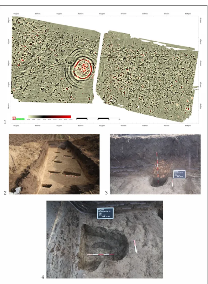
Fig. 1. Polgár-Csőszhalom. 1. The topography of the tell enclosed by a ditch system and the horizontal settle- ment with the investigated areas, the reconstruction is based on magnetometer surveys, field surveys and ex - cavations (after Raczky – Anders 2010). 2. Polgár-Csőszhalom. Magnetometric plan and excavation trenches (1993–1994: Fractal Ltd.).
371
P. Raczky – A. Anders – N. Faragó – G. Márkus: Short report on the 2014 excavations at Polgár-Csőszhalom
Fig. 2. Polgár-Csőszhalom. 1. Magnetometric plan, -15 nT/m–25 nT/m (2013: Archeodata 1998 Ltd.). 2. Detail of the magnetometric plan and the excavation trenches in 2014. 3. Magnetometric plan on the 1:102000 scale con- tour map (L. Rupnik).
372
P. Raczky – A. Anders – N. Faragó – G. Márkus: Short report on the 2014 excavations at Polgár-Csőszhalom
Fig. 3. Polgár-Csőszhalom, Trench I in 2014. 1. field work. 2–3. Feature 6. 4. Feature 5 (Photo: P. Raczky).
373
P. Raczky – A. Anders – N. Faragó – G. Márkus: Short report on the 2014 excavations at Polgár-Csőszhalom
Fig. 4. Polgár-Csőszhalom, Trench I in 2014. 1. The view of Trench I. 2. Feature 1. 3. Feature 2 (Photo: P. Raczky).
374
P. Raczky – A. Anders – N. Faragó – G. Márkus: Short report on the 2014 excavations at Polgár-Csőszhalom
Fig. 5. Polgár-Csőszhalom. 1. Magnetometric plan, -10 nT/m–70 nT/m (2013: Archeodata 1998 Ltd.). 2. Trench II in 2014. 3. Str. 3–4. 4. Str. 2 (Photo: P. Raczky).
375