DOKTORI (PhD) ÉRTEKEZÉS
Spatio-Temporal Analysis of Vegetation Habitats in Riparian Wetlands
(Hullámtéri vizes élőhelyek vegetációjának térbeli és időbeli vizsgálata)
Kollár Szilvia
Nyugat-magyarországi Egyetem (Sopron) Erdőmérnöki Kar
Kitaibel Pál Környezettudományi Doktori Iskola K4 Geoinformatikai Program
Témavezetők:
Dr.Vekerdy Zoltán
Faculty of Geo-Information Science and Earth Observation University of Twente, Enschede, Hollandia
Prof.Dr.habil Márkus Béla Nyugat-magyarországi Egyetem Geoinformatikai Kar, Székesfehérvár
Sopron 2014
(Hullámtéri vizes élőhelyek vegetációjának térbeli és időbeli vizsgálata)
című értekezés doktori (PhD) fokozat elnyerése érdekében készült
a Nyugat-magyarországi Egyetem Kitaibel Pál Környezettudományi Doktori Iskolája K4 Geoinformatikai Programja keretében.
Írta: Kollár Szilvia
Témavezetők:
Dr.Vekerdy Zoltán
Elfogadásra javaslom (igen / nem)
(aláírás) Prof.Dr.habil Márkus Béla
Elfogadásra javaslom (igen / nem)
(aláírás) A jelölt a doktori szigorlaton ...%-ot ért el.
Sopron, ...
a Szigorlati Bizottság elnöke Az értekezést bírálóként elfogadásra javaslom (igen / nem)
Első bíráló (Dr. ...) igen / nem
(aláírás) Második bíráló (Dr. ...) igen / nem
(aláírás) Esetleg harmadik bíráló (Dr. ...) igen / nem
(aláírás) A jelölt az értekezés nyilvános vitáján ...%-ot ért el.
Sopron, ...
a Bírálóbizottság elnöke A doktori (PhD) oklevél minősítése ...
Az EDT elnöke
“Blessed be the LORD God, Who alone works wonders.”
Psalms 72:18
The dissertation demonstrates automated image classification techniques applied to recent high resolution (<5 m/pixel) aerial imagery for vegetation classification purposes. It was proved based on a riparian wetland site for different years that the application of a combined spectral-textural feature set in the supervised class description based fuzzy algorithm signif- icantly enhances the classification performance compared to the use of spectral or textural features only. The best classification results gave 87-88% overall accuracies with a simple and an extended classification scheme, defined after botanical and silvicultural reference data.
Furthermore, classification algorithm transfer was considered for automated applications in space and time. It was proved that the automated mapping of poplar stands is feasible by transferred decision tree classification approach, under those conditions that the samples selected in the training site only include the hybrid poplar forest stand type. By systematic Jeffries-Matusita class separability analysis, the GLCM (Grey Level Co-occurrence Matrix) standard deviation (STDEV) was found as a significant and stable textural parameter for the analysis of vegetation pattern differences in colour-infrared aerial images. For the most recent CIR imagery it was proved that a decision tree classifier with GLCM STDEV and vegetation index applied to the separation of high and low vegetation, is automatically transferable to former CIR images. Based on the supervised classification of NIR-R-G im- ages GLCM STDEV was found as a single descriptor without the use of vegetation index for the detection of high and low vegetation. Decision tree transferability was proved for further classification automation in space and time, with the above mentioned generalized classification scheme applied to the separation of forested and non-forested wetlands. These classification methods help in the effective processing of large aerial image archives and their application is proposed for silvicultural and botanical inventories.
A disszertáció témája nagy felbontású (<5 m/pixel) légifelvételekre alkalmazott automati- kus képosztályozási eljárások kidolgozása vegetációtérképezés céljából. A szerző hullámtéri tesztterület különböző időpontból származó felvételeire bebizonyította, hogy az osztályjel- lemzésen alapuló (class description based) fuzzy algoritmus mint tanítóterületekkel végzett objektum alapú osztályozás akkor adja a legjobb vegetációosztályozási eredményt, ha az osztályozó bemeneti paraméterei spektrális és texturális jellemzőket is tartalmaznak, ellen- tétben a kizárólag spektrális vagy texturális paraméterek alkalmazásával. A legjobb osz- tályozási eredmények 87-88%-os átlagos megbízhatóságot eredményeztek egy botanikai és erdészeti adatokon alapuló egyszerű és kibővített osztályozási rendszerrel. A szerző vizsgálta az osztályozási algoritmus térbeli és időbeli átvitelét. Bebizonyította, hogy a nyáras osztály automatikusan térképezhető a döntési fa képosztályozó átvitelével azon feltételek mellett, hogy a tanítóképen kiválasztott minták első faállományának típusa kizárólag nemes nyáras lehet. A szerző szisztematikus Jeffries-Matusita elválaszthatósági elemzés alkalmazásával kimutatta, hogy a GLCM (Grey Level Co-occurrence Matrix) szórás (standard deviation, STDEV) jellemzője szignifikáns és stabil paraméter a vegetációs mintázatok változásának elemzésére infraszínes légifelvételeken. Az elérhető legújabb CIR felvételekre létezik olyan döntési fa képosztályozó algoritmus GLCM STDEV és vegetációs index felhasználásával alacsony és magas vegetáció elkülönítésére, mely a mintaképen való tesztelést követően au- tomatikusan alkalmazható korábbi infraszínes légifotókra. NIR-R-G spektrális felbontású felvétel tanítóterületekkel való osztályozása alapján a szerző bebizonyította a GLCM STDEV paraméter kizárólagos alkalmazhatóságát a vegetációs index nélkül, alacsony és magas vege- táció szétválasztására. Az osztályozás további automatizálására vonatkozóan bizonyításra került, hogy adott tesztképre kidolgozott döntési fa képosztályozó térben és időben egyaránt átvihető, a fent említett generalizált osztályozási rendszerrel, erdős és nem erdős hullámtér automatikus elkülönítésére. Ezen módszerek alapján nagy méretű légifelvétel-adatbázisok hatékony és gyors feldolgozása lehetővé válik, melynek botanikai és erdészeti alkalmazása nagy jelentőséggel bír.
First of all, I would like to thank for the great support of my supervisors over the past five and a half years. Dr.Zoltán Vekerdy, assistant professor at the Department of Water Resources, ITC (Faculty of Geo-Information Science and Earth Observation, University of Twente, En- schede, the Netherlands), honorary associate professor at the Department of Geoinformation Science, Faculty of Geoinformatics, University of West Hungary (Székesfehérvár) and visit- ing professor at the Department of Water and Waste Management, Faculty of Agricultural and Environmental Sciences, Szent István University (Gödöllő, Hungary) who has been my second father in that period believing in my research often more than me and his continuous encouragement helped me going through difficult periods. Prof.Dr.habil Béla Márkus, the head of the Land and GI Knowledge Center and professor at the Department of Geoinfor- mation Science, Faculty of Geoinformatics, University of West Hungary who has supported me from the very first beginning with my application for the PhD grant at the University of West Hungary and for a 3-month research stay at the Department of Geoinformatics in the University of Salzburg.
I wish to express my sincerely gratitude to the University of West Hungary, Faculty of Forestry (Sopron, Hungary) for the provided PhD grant between 2008–2011 and my spe- cial thanks to all the staff members of the Faculty of Geoinformatics (Székesfehérvár) and specially to my colleagues at the Department of Geoinformation Science and at the De- partment of Photogrammetry and Remote Sensing, where I have done the main part of my research in a caring and supporting environment. I am grateful to the “Central European Exchange Program for University Studies” (CEEPUS) providing me a research grant for three months at the Department of Geoinformatics in the University of Salzburg, where I focused on the application of advanced remote sensing methods (including object-based image analysis), which became the backbone of my further investigations. I convey my thanks to Dr.László Martinovich who helped me organising a short research (3 months) at the Institute of Geodesy, Cartography and Remote Sensing (FÖMI, Budapest) in 2009. I highly appreciate the support of Trimble Geospatial Munich (Germany) for providing me the eCognition Developer software for my research, after I spent a fruitful internship period at the company in 2010. Concerning my shorter stays (3-14 days) in Enschede for research discussions with my supervisor, I am specially grateful to Marcsi Vekerdy, the wonderful wife of my supervisor, who has been always so caring and hospitable at their house, and thus, during my work at the Technical University of Dortmund a small “Hungarian island”
was not so far from me geographically.
I also thank to the Fertő-Hanság National Park (Gábor Takács) in Sarród and to the Forestry Directorate (Judit Péter) in Szombathely (Hungary) for giving me access to the botanical
v
and silvicultural data, and to István Hahn (Eötvös Loránd University, Department of Plant Taxonomy and Ecology, Budapest) for his guidance during the field investigations and for his support regarding the botanical aspects of the study.
As a research stuff member at the Department of RIM (Spatial Data Analysis) at the Faculty of Spatial Planning, in the Technical University of Dortmund (Germany) since 2012, I would like to express my sincere thanks to the Head of the Department, Univ.- Prof.Dr.habil Nguyen Xuan Thinh for his support and understanding especially concerning the most intensive periods of finishing the dissertation.
I am so grateful for my family, parents, two sisters and brother, my grandparents and friends geographically close and far and my loved husband, who believed in me and gave encouragement always.
Abstract / Kivonat iii
Acknowledgements v
Contents vii
List of Figures x
List of Tables xii
Abbreviations xiii
1 Introduction 1
1.1 General introduction . . . 1
1.2 Aims & structure of the research . . . 3
2 Riparian vegetation mapping based on remote sensing: a review 4 2.1 Wetlands and vegetation mapping . . . 4
2.2 The remote sensing perspective . . . 5
2.3 Analysis of high spatial resolution optical imagery . . . 6
2.3.1 Availability of imagery . . . 6
2.3.2 Applications . . . 8
2.3.3 Spectral characterization of images . . . 9
2.3.4 Visual image interpretation . . . 10
2.3.5 Pixel- versus object-based image analysis . . . 11
3 Materials 15 3.1 Study area. . . 15
3.1.1 Effects of hydrological changes on the vegetation . . . 16
3.1.2 Botanical mapping . . . 18
3.1.3 Remote sensing analysis . . . 20
3.2 Applied imagery . . . 21
3.3 Botanical and silvicultural maps . . . 22
4 Methods 24 4.1 Image segmentation . . . 24
4.2 Spectral characterization. . . 25
4.3 Geostatistical characterization. . . 26
4.3.1 Texture analysis based on GLCM. . . 27 vii
Contents viii
4.3.2 The semivariogram . . . 30
4.4 Class separability analysis . . . 31
4.5 Supervised classification algorithms. . . 33
4.5.1 Class description based fuzzy (CDBF) algorithm . . . 34
4.5.2 Decision tree classification . . . 36
4.6 Accuracy assessment . . . 38
5 Spectral-textural classification 41 5.1 Sample application to the study site of Dunaremete . . . 41
5.1.1 Separation of water bodies . . . 44
5.1.2 Classifying vegetation . . . 46
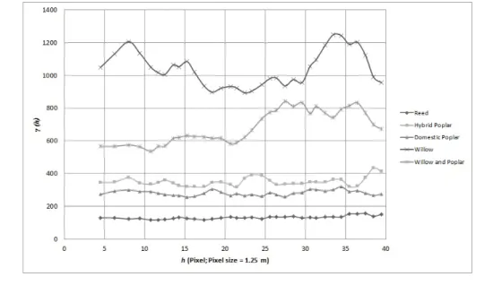
5.1.3 Application of geostatistics . . . 48
5.1.4 Feature selection . . . 50
5.1.5 Classification algorithm . . . 51
5.1.6 Results . . . 52
5.1.7 Discussion . . . 54
5.2 Classification scheme . . . 56
5.2.1 Extending the classification scheme. . . 57
5.2.2 Result & discussion . . . 59
6 Classification transferability 61 6.1 Necessity for an objective approach . . . 62
6.2 Classification transferability in the spatial dimension . . . 62
6.2.1 Adequacy of the principal test site . . . 63
6.2.2 Applied classification scheme . . . 63
6.2.3 Expected results . . . 65
6.2.4 Difficulties with the CDBF classification algorithm . . . 66
6.2.5 Decision tree approach . . . 68
6.2.5.1 Application to the main test site . . . 68
6.2.5.2 Analysis of classification algorithm transfer . . . 70
6.2.6 Results and discussion . . . 73
6.3 Classification transferability in the temporal dimension. . . 78
6.3.1 Separation of water bodies . . . 79
6.3.2 Transfer of classification algorithms . . . 80
6.3.3 Class separability analysis . . . 82
6.3.3.1 Detecting a stable parameter for temporal vegetation analysis 83 6.3.3.2 Detecting vegetation with structural differences . . . 86
6.3.4 Transferring a generalized classification scheme . . . 87
6.3.5 Results . . . 90
6.4 Spatio-temporal classification transferability . . . 91
7 Summary 94 8 Conclusions & future research 96 8.1 Conclusions . . . 96
8.2 Future research . . . 97
9 Theses 99
A Aerial Images (1999-2008) 101
B Ancillary Data 103
C Feature separability analysis 106
Bibliography 110
List of Figures
2.1 Reflectance curve of vegetation . . . 10
2.2 Comparison of pixel- and object-based approaches . . . 14
3.1 Map of the Szigetköz Danubian floodplain . . . 17
3.2 Willow and poplar forests in the Szigetköz . . . 18
3.3 Test sites in the Szigetköz . . . 21
4.1 Semivariogram . . . 30
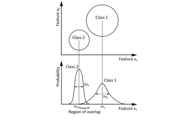
4.2 Problem of class separability . . . 32
4.3 Example for class description . . . 35
4.4 Example for membership function . . . 35
4.5 Example for a decision tree . . . 37
5.1 The study site of Dunaremete (DR) . . . 42
5.2 Analysis steps applied to DR test site . . . 43
5.3 Segmentation and classification of water bodies (DR,2008) . . . 45
5.5 Willow species in the test site of Dunaremete (2010) . . . 47
5.4 Hybrid poplar stand in the Szigetköz (2010) . . . 47
5.6 Target vegetation classes by square segments from 2008 . . . 48
5.7 Semivariogram analysis of vegetation classes in 2008 . . . 49
5.8 Classification results with the simple classification scheme for DR site (2008- 1999). . . 54
5.9 Comparing chessboard and multi-resolution segments. . . 55
5.10 Hierarchical classification scheme applied to image DR, 2008 . . . 58
5.11 Classification with the complemented scheme for DR, 2008 . . . 59
6.1 A unique classification scheme for the test sites of DK, DR and ASV in 2008, based on separate classification results . . . 64
6.2 Transferred CDBF classification algorithm to DK, 2008 . . . 67
6.3 Comparison of classification results applying CDBF and DT algorithms to DR, 2008 . . . 69
6.4 Structure of the decision tree regarding the extended classification scheme for DR, 2008 . . . 70
6.5 Methods applied for the analysis of decision tree transfer. . . 71
6.6 Classification result after transferring DT algorithm to the scene of DK, 2008 72 6.7 Decision tree computed from DK, 2008. . . 75
6.8 Transferring decision tree from DK to DR and ASV . . . 76 6.9 Modified decision tree based on DK (2008) focusing on the separation of HP. 78
x
6.10 Class description of water bodies applied to the 2008 and 1999 image scene
(DR) . . . 79
6.11 Classification results after transferring CDBF and DT algorithms to the for- mer (1999) scene of DR . . . 80
6.12 Structure of the decision tree with the simple classification scheme, DR, 2008 81 6.13 Stable parameter assessment . . . 84
6.14 DT1 structure for the separation of HV and LV based on DR(2008) . . . 88
6.15 DT2 structure for the separation of HV and LV based on DR(2008) . . . 89
6.16 Comparison of DT-based classification results with a generalized classification scheme for DR (2008,1999) . . . 90
6.17 Transferred DT-based classification results with a generalized classification scheme for DK (2008) . . . 93
A.1 Orthophoto 1999, DR . . . 101
A.2 Orthophoto 2005, DR . . . 102
A.3 Orthophoto 2008, DR . . . 102
B.1 Botanical habitat map . . . 103
B.2 Subsets of habitat maps for DR test site . . . 104
B.3 Silvicultural data (Forest Stand Type) about the test sites . . . 105
List of Tables
3.1 Detailed information on the applied imagery. . . 22
4.1 The most important textural parameters of GLCM and GLDV . . . 29
5.1 Comparing textures for different geometric resoutions . . . 44
5.2 Vegetation indices applied to aerial images (2008,2005,1999) . . . 45
5.3 Statistical separability analysis for the originally chosen target vegetation classes in DR, 2008 . . . 51
5.4 Accuracy assessment of the first classification results (DR, 2008-1999) . . . . 52
5.5 Error matrix for DR, 2008 (best classification result) . . . 53
5.6 Comparing results from different segmentation approaches based on accuracy calculation. . . 55
5.7 Class separability analysis by the merge of certain vegetation classes . . . 56
5.8 Comparison of accuracy measures concerning the use of different VIs for DR, 2008 . . . 60
6.1 Comparison of two-level classification scheme for the 3 test sites. . . 65
6.2 Comparing accuracy measures related to CDBF and DT classification algo- rithms, DR, 2008 . . . 68
6.3 Error matrix for the result of transferred decision tree for DK, 2008 . . . 73
6.4 Accuracy measures for HP class based on different DT transfers. . . 77
6.5 Accuracy comparison for the 3 test sites based on the modified DT . . . 77
6.6 Accuracy of Low vegetation classification in DT-transfer . . . 81
6.7 Separability analysis for class-pairs with Reed (DR, 1999, 2008) . . . 84
6.8 Similarity test for Reed (1999-2008) by class separability analysis in DR site. 85 6.9 Separability test for Reed (2008) and other vegetation classes (1999) by class separability analysis in DR site. . . 86
6.10 Separability analysis for class pairs with HP (DR, 1999, 2008). . . 86
6.11 Separability test of Willow (2008) and other vegetation classes (1999) by class separability analysis in DR site. . . 87
6.12 Separability test of Willow & poplar (2008) and other vegetation classes (1999) by class separability analysis in DR site. . . 87
6.13 Accuracies for spatio-temporal transferability . . . 92
C.1 Feature separability analysis for DR, 1999 . . . 107
C.2 Feature separability analysis for DR, 2005 . . . 108
C.3 Feature separability analysis for DR, 2008 . . . 109
xii
Á-NÉR Hu. ÁltalánosNemzeti ÉlőhelyosztályozásiRendszer ASV Ásványráró test site
B Blue band
BlueNDVI Blue Normalized DifferenceVegetation Index BSG BareSoil mixed with Grass
CDBF ClassDescription Based Fuzzy (algorithm) DK Dunakiliti test site
DN Digitalnumbers (radiometric values)
DP DomesticPoplar
DP-R DomesticPoplar-Robinia DR Dunaremete test site
DT Decision Tree (classification algorithm) FAFK Hu. Fafaj kód (code of tree species)
FATI1 Hu. Az1. faállománytípus kódja (forest stand type) FÖMI Földmérési és Távérzékelési Intézet
(En. Institute of Geodesy, Cartography and Remote Sensing, Budapest) FST ForestStandType
G Green band
GLCM Grey Level Co-occurrrenceMatrix GLDV Grey Level Difference Vector
GreenNDVI Green NormalizedDifferenceVegetation Index
HP HybridPoplar
HR Highresolution
HV HighVegetation
JM Jeffries-Matusita (statistical separability analysis) xiii
Abbreviations xiv
LV Low Vegetation
mNDVI modifiedNormalizedDifferenceVegetation Index MR Multi-resolution
MS Multispectral
NDVI NormalizedDifferenceVegetation Index NFI National ForestInventory
NIR Nearinfrared band
OA Overall accuracy
OBIA Object-BasedImage Analysis PC1 The first principalcomponent
R Red band
RD ReeD
RS Remotesensing
UWH University of WestHungary VED Vegetation on Edges and Dams VHR Very highresolution
W Willow
WP Willow &Poplar
Introduction
1.1 General introduction
Over the past 50 years, the rapid and extensive change of ecosystems induced a significant decrease in the biological diversity (MEA,2005) and in this regard the sixth great extinction wave is already occurring in the Earth’s biota (Mendenhall et al.,2012). Therefore, in the European Union the “EU 2020 biodiversity strategy” has been developed related to the Eu- ropean Habitats and Birds Directive, in order to halt the loss of biodiversity and ecosystem services in the EU by 2020 (Europian Commission,2011). Besides a policy framework, an appropriate technology is needed for the monitoring of ecosystems, where remote sensing methods are representing objective and time-effective techniques for the continuous obser- vation of ecosystems from above (Lang et al.,2013). Beyond satellite imagery, archive aerial photography provides the basis for the historical characterization of the variability within ecosystems as well as for strategy development related to the management of ecological integrity (Landres et al.,1999).
Wetland ecosystems are among the most productive ecosystems in the world, but they have reached a vulnerable status, wherefore a conservation and sustainable development strategy has been formulated in the Ramsar Convention on Wetlands (1971) (Maltby and Barker, 2009). The main drivers of the degradation and loss of inland wetlands are infrastructure development (such as dams, dikes and levees), land conversion, water withdrawals, pollution, overharvesting and the introduction of invasive alien species. Furthermore, it has been
1
Chapter 1. Introduction 2 projected, that global climate change and nutrient loading have become an important factor for the next 50 years (MEA,2005).
Detailed monitoring of riparian floodplains is vital for an effective restoration management, which requires large scale inventory, often carried out by traditional systematic field surveys.
However, traditional field observation cannot provide a synoptic and systematic overview about recent changes because of its limitations in space and time. Under extreme flooding conditions it could be often impossible to carry out field investigations in a certain time frame. Beyond that, due to high personal costs and possible inconsistencies in the experi- ences of different surveyors, the application of remotely sensed images with high geometric resolution came in the focus of interest. Aerial photo archives contain images from earlier periods than the first satellite images, providing a challenging opportunity for analysing vegetation habitat changes over several decades.
Visual interpretation of aerial photography has been extensively applied for decades for fine- scale vegetation habitat mapping and forest inventories (Morgan et al.,2010). Since an ever increasing amount of remote sensing data is being produced nowadays in a broad range of spatial, spectral, radiometric and temporal resolutions, automated information extraction methods came into the focus of interest, which can also compete with the subjective na- ture of human interpretation. With the increasing computation power in the recent years, automated approaches have gone through a rapid development and can provide objective analysis methods for larger areas.
In the analysis of high spatial resolution (under 5 m/pixel) imagery traditional pixel-based image classification methods often fail due to the wide range of spectral responses related to certain target classes, e.g., a given forest stand in a complex riparian vegetation environment.
A potential solution is applying object-based (segmentation-based) image analysis (OBIA) methods, where, instead of individual pixels, image segments as group of pixels become the focus of the image analysis and the classification.
Beyond the automated analysis of separate image scenes, a harmonized automation in the spatial and temporal domain is essential when large areas are covered by time series of several images (e.g., aerial photos).
1.2 Aims & structure of the research
Based on the above-described problems, the present research is aiming at developing a vegetation habitat mapping method based on high spatial resolution aerial imagery, using automated digital image analysis techniques.
In thefirst step an automated classification method is to be found for an appropriate sepa- ration of vegetation habitat classes, based on a selected test site in the Szigetköz floodplain, using aerial images from the recent years.
Thesecond step is to extend the vegetation habitat classification method developed for one image to other areas in the same riparian wetland.
In thethird stepan appropriate analysis and classification method is sought for the detection of similar vegetation habitats in distinct years, concentrating on a selected test site.
Thefourth stepis related to the spatio-temporal transferability of the classification, where it is aimed at finding a universal classification algorithm to automatically classify forested and non-forested wetlands based on a principal training site (image scene), where the algorithm is applicable to aerial images scenes covering the same wetland and having the same spatial resolution, but potentially coming from different times.
In the main chapters of the dissertation firstly wetland and vegetation mapping is described briefly, followed by fine-scale riparian vegetation mapping techniques using remote sensing (Chapter2). Chapter3addresses the study area and the data used in the analysis. Chapter4 describes the applied methods in detail. The applications of the methods, their further development and the scientific findings are demonstrated in Chapter5 and Chapter6. The closing chapters are Chapter 7 with the summary, Chapter 8 with conclusions and future prospects and in the end scientific results (theses) are presented (Chapter9).
Chapter 2
Riparian vegetation mapping based on remote sensing: a review
2.1 Wetlands and vegetation mapping
Wetlands have been listed among the world’s most productive ecosystems (Maltby and Barker,2009). Out of them floodplain environments in their natural state are of particular importance due to their high biodiversity providing critical habitats for many plants and animals and further on being a natural element in the maintenance of water quality (Ander- sen,2004). During the last decades wetlands have become the most vulnerable ecosystems.
An intergovernmental treaty called Ramsar Convention on Wetlands (1971) is aiming at the wise use of wetlands by improving their management and developing a comprehensive information base on the status and trends of wetlands, their values and the major drivers of adverse change (Maltby and Barker,2009).
Since vegetation in general provides a base for all living beings and plays an essential role in affecting global climate change, with an influence on terrestrial CO2 by the net ecosystem exchange of CO2between the atmosphere and forest ecosystems (Xiao et al.,2004), its classi- fication and mapping has been an important task for managing natural resources (Xie et al., 2008). Analysing vegetation structure is important for the characterization of wildlife habi- tat quality, where animal species both within and among habitats are partitioned according to the vegetation composition (Wood et al., 2012). Changes in vegetation are evidence of
4
environmental impacts which are important for the functioning of the ecosystem and for biodiversity maintenance (Ihse,2007).
Vegetation and land cover maps for a certain reference time or over a continuous period at different scales are essential instruments for the global climate modelling and for ecological and biodiversity studies (Millington and Alexander,2000) and provide valuable information for understanding natural and man-made environments (Xie et al.,2008). Obtaining current states of vegetation is essential for the planning of vegetation (habitat) protection and restoration. Millington and Alexander(2000) summarized the need for vegetation maps in two crucial points: firstly to communicate a complex set of information about vegetation in a simplified and spatially referenced form, secondly to provide spatially referenced numerical data about vegetation that can be used for analyses.
2.2 The remote sensing perspective
Traditional methods for vegetation analysis, like field surveys, map interpretation and an- cillary data analysis are often not effective enough, since they are time consuming, often provide information about lagged dates and have high expenses (Xie et al.,2008). Although ground based field monitoring can provide highly detailed information about the vegetation cover, it is very time intensive and could be only feasible over small spatial extents (Levick and Rogers, 2008). Davidson and Finlayson (2007) emphasized the essential role of Earth observation (remote sensing) techniques adopted by the Ramsar Convention on Wetlands for the inventory, assessment, monitoring and management of wetland ecosystems at widely differing spatial scales.
Remote sensing is a promising analysis method where the Earth surface is sensed from above, without touching or accessing it. Remote sensing can provide the basis for vege- tation classifications in different ground spatial resolutions from global (e.g., for climate and biogeochemical models) through regional scale (e.g., for habitat mapping or watershed modelling) to species level. Spatial scale or resolution, commonly referred to as ‘pixel size’
in digital images, is a key element of remote sensing. At the global and continental scales the 1-km-spatial resolution has been commonly applied, e.g., based on AVHRR (Advanced Very High Resolution Radiometer) (Running et al.,1995), SPOT4-VEGETATION (SPOT, French: Satellite Pour l’Observation de la Terre) or MODIS (Moderate Resolution Imaging
Chapter 2. Classifying riparian vegetation based on remotely sensed images 6 Spectroradiometer) satellite imagery (Xie et al., 2008). Medium ground spatial resolution about 30 m/pixel e.g., in case of the Landsat-system, is suitable for regional satellite map- ping, applied for instance to biodiversity assessment and conservation planning in the study of Fuller et al.(1998). In the study of Ozesmi and Bauer(2002) remote sensing techniques are applied for different types of wetlands from global (AVHRR, 1 km/pixel) to medium scale (SPOT, 20 m/pixel) and concluded that satellite-based remote sensing is especially appropriate for initial reconnaissance mapping and continued monitoring of wetlands over large geographical areas. General information on water regime and vegetation productivity can be well-detected, however, they cannot provide the detailed information available from high geometric resolution imagery included aerial photography. Several studies (e.g., Yu et al., 2006; Johansen et al., 2007) emphasized the advantage of using high spatial reso- lution remote sensing images for the analysis of riparian zones with restoration purposes due to a decrease in valuable ecological functions (e.g., vegetation structure) provided by riparian forests to streams (Gergel et al.,2007). This kind of imagery is described in detail in the next section.
The analysis of remotely sensed imagery brings another perspective to vegetation studies, by means of being capable of detecting patterns at different spatial scales which may not be obvious from the ground and this kind of analysis helps in the characterization of ecosystems in larger spatial extents. Beyond that, a great advantage of remotely sensed data is the potential for systematic observations at various scales through the extension of possible data archives from present time to over several decades back (Xie et al.,2008).
2.3 Analysis of high spatial resolution optical imagery
2.3.1 Availability of imagery
Satellite and aerial images in various spatial scales are able to capture the spectral reflectance of different land cover types in distinct wavelength intervals of the electromagnetic spectrum.
The optical wavelength interval originally means the range between 400 nm (violet) to 2500 nm (shortwave infrared) (Lefsky and Cohen, 2003), however, in the current study we have been concentrating on the interval between 450 nm and 900 nm including blue, green, red and near-infrared bands, discussed commonly in multispectral remote sensing applications.
Although medium resolution satellite imagery (e.g., Landsat with 30 m/pixel) have been effective in mapping seasonal characteristics of the vegetation for larger extents since 1972, their spatial resolution has been too low for the analysis of those riparian units which can vary in composition and form below that scale (Davis et al.,2002).
InLefsky and Cohen(2003) analogue aerial photography has been stated as the oldest, most frequently used and best understood form of remote sensing. For mapping small ecosystems, fine-scale landscape features and successional pathways aerial imagery has proved to be effective due to the often present high spatial resolution, radiometric (tonal) detail and historic availability, dating already from the early 1930s in some cases (Green and Hartley, 2000;Morgan et al.,2010). With higher ground spatial resolutions, often less than 1 m/pixel, and with slowly declining costs the use of airborne sensors is reasonable for the improvement of vegetation mapping accuracies (Davis et al., 2002). The spatial scale for airphotos is a function of camera focal length and aircraft flying altitude and also depends on the film’s halide crystal grain size, where a moderate resolution photo would have a 1:12000 scale, equivalent to a spatial resolution of about 0.4 m (Lefsky and Cohen, 2003) and hereby, provides very high resolution (VHR) imagery, under 1 m/pixel.
For the digitalisation of hard-copy photographs it is suggested to use a pixel size which is approximately 20% of the output size of the object of interest (Hall,2003) which is followed by orthophoto-production with an appropriate rectification process. Considering digital aerial photographs directly obtained from digital cameras, a single CCD (charge-coupled device) sensor with mosaic optical filtering and near-infrared airborne camera systems can produce images at very high spatial resolutions (under 0.25 m/pixel) (Wulder et al.,2004).
Beyond analogue and digital aerial photography, the increasing availability of commercially operated high spatial resolution (defined as under 5 m/pixel in Johansen et al., 2010a;
Blaschke et al., 2011) multispectral satellite imagery (e.g., IKONOS with ∼3.28 m/pixel from 1999; QuickBird with ∼2.44 m/pixel from 2001; GeoEye-1 with 1.65 m/pixel from 2008; WorldView-2 with∼1.84 m/pixel from 2009) vegetation mapping and monitoring can operationally develop focusing on narrow riparian zones and certain stand parameters such as height, age and foliage projective cover (Blaschke et al., 2011). It is essential that in case of satellite-borne high-resolution sensors the collection of data is ensured from a stable platform, at regular time intervals, with a relatively large footprint size (Wulder et al.,2004).
Chapter 2. Classifying riparian vegetation based on remotely sensed images 8 2.3.2 Applications
Numerous studies analysed high resolution imagery for conservation and restoration plan- ning issues. In the European Union it often means the monitoring of Natura 2000 territories as part of an effective assessment of biodiversity. Natura 2000 is a European Directive, which was designed to ensure the conservation of the most seriously threatened habitats and species covering almost 20% of the EU territory. In the context of Natura 2000 and nature conser- vation the so-called SPIN project (“Spatial Indicators for European Nature Conservation”) emphasized the advantage of applying high resolution stereo camera airborne scanner data in a German case study for the classification of phytosociological communities (Bock et al., 2005). In the study ofFörster and Kleinschmit (2008) forest types have been delineated at three different levels (forest habitats, crown combinations, crown types of single-tree species) based on a QuickBird scene of the Bavarian submontane area, where the forest habitat level was similar in size to the terrestrially mapped Natura 2000 areas. Langanke et al. (2007) aimed at assessing the mire conservation status of a raised bog in Austria as a single Natura 2000 site and analysed different types of aerial photographs (black & white, colour infrared and true colour) dating back to 1953 (regarding the oldest airphoto) with two interpre- tation techniques: a standard aerial photo-interpretation and a multi-scale object-based classification, which are described in detail in the next sections. A comprehensive review on colour infrared (CIR) aerial photography concerning several decades of vegetation map- ping in Sweden emphasized the significance of CIR aerial imagery as a fundamental tool in nature conservation and environmental planning (Ihse,2007). Outside EuropeGergel et al.
(2007) have mapped harvested and intact forests for riparian restoration planning in coastal British Columbia, Canada at different spatial resolutions and found a significantly better classification performance using high geometric resolution.
Beyond the general vegetation mapping methods with restoration purposes, the application of high spatial resolution imagery has been essential for the assessment of forest resources, concerning forest structure analysis and the measurements of forest biophysical data (e.g., LAI, leaf area index, above-ground biomass and NPP, net primary production) (Wulder et al., 2004). Research studies related to the HR multispectral imagery based estimation of forest structure listed the forest structural parameters. Franklin et al. (2000) analysed airborne multispectral video images and airborne spectrographic images (the highest resolu- tion was 0.3 m) for the classification of pure and mixed-wood forest stands from ecoregions
in Alberta and New Brunswick, Canada and proved the advantages of using images with high spatial resolution. The analysis of digitized CIR aerial photographs at 0.5 m/pixel resolution provided promising results for forest attribute estimation in the study of a bo- real forest in southern Finland (Tuominen and Pekkarinen, 2005). Hájek (2008) applied medium-format digital aerial images (resampled to 0.5 m) for the purpose of automated up- dating of an existing GIS forest management database in southern Moravia, Czech Republic and highlighted the significance of CIR aerial images as an alternative to traditional aerial photos and HR satellite data. Concerning the analysis of high resolution satellite imagery, Wezyk et al.(2004) applied QuickBird imagery for the mapping of forest canopies in south Poland and presented the potential of classifying the development stage (aging) of the forest stands. Kim et al.(2009) presented the application of IKONOS images to delineate forest types (decidious, evergreen, mixed) in North Carolina, US and proved that the incorpora- tion of textures (discussed later in Chapter 4.3.1) resulted in a classification agreeable with manually interpreted forest types. In the forest structure study of Kayitakire et al.(2006) the estimation of coniferous forest variables (age, top height, circumference and basal area) in eastern Belgium based on 1-m resolution IKONOS-2 imagery gave promising results for the application in forest planning. For the analysis of similar forest structural parameters Ozdemir and Karnieli(2011) presented the potential of World-View-2 multispectral imagery applied to a dryland plantation forest in Israel. Concerning financial issues Hájek (2008) emphasized, that although the radiometry of the 8-bit/pixel aerial imagery (used in his study) can hardly compete with the 11-bit IKONOS satellite image data (the geometric resolution in the multispectral mode is lower there: 3.28 m/pixel) or with a 12-bit/pixel data from the Digital Mapping Camera (DMC), the cost of analogue images and hereby, the lower primary investment plays an important role in the management of forestry. Although, it is not in the scope of this study, the potential of combining HR (aerial/satellite) imagery with LiDAR (Light Detection and Ranging, also called as laser scanning) data has been emphasized in various research studies recently, where the identification of individual trees (tree crowns) and other forest parameters can be significantly improved (Király and Brolly, 2006;Levick and Rogers,2008;Morgan et al.,2010;Blaschke et al.,2011).
2.3.3 Spectral characterization of images
Looking back to the history of digital image analysis techniques in remote sensing appli- cations spectral approaches have formed the backbone of multispectral (MS) classification
Chapter 2. Classifying riparian vegetation based on remotely sensed images 10
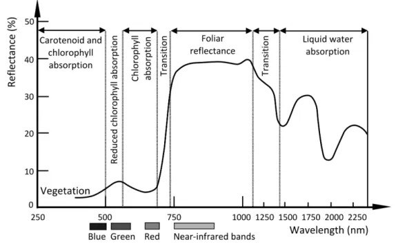
Figure 2.1: Reflectance curve of vegetation afterJensen (2014).
methods. According to the spectral resolution of the MS imagery, digital numbers (DN) are captured for different wavelength intervals which are associated with a certain band.
In case of analogue aerial photography the available spectral bandwidths depend on the spectral sensitivity of the film, where the normal colour film (now not considering the black
& white film with only one panchromatic layer) includes blue (B), green (G) and red (R) sensitive layers, whereas a colour-infrared film has the near-infrared (NIR) layer besides G and R (Jensen,2014). The development of colour-IR film is related to World War II, where they were applied to detect painted targets that were camouflaged to look like vegetation (Lillesand et al.,2008). According to the unique spectral characteristics (high reflectances) of vegetation in the near-infrared region of the spectrum (see in Figure2.1) the false colour composite of bands (with NIR,R,G generally) is often applied for visualisation purposes, emphasizing the vitality of the vegetation in reddish colours (see an aerial image example with the B-G-NIR band combination representing a part of the latter analysed test site in Figure 2.2).
2.3.4 Visual image interpretation
After establishing a relationship between the vegetation structural characteristics and the reflectance (spectral) characteristics of the vegetation, visual image interpretation or image
classification algorithms are used to identify areas with similar reflectance characteristics for the same vegetation structural class (Lymburner, 2005). The traditional analysis of aerial photography has been based on human visual interpretation with manual digitalisation of thematic units complemented with ground truth data from the field inventory, which results in a very time- and labour-intensive approach (Mathieu et al.,2007). Visual interpretation can address a high level of detail, since the human mind is amazingly good at recognizing and associating complex elements in an image like gray-scale tone, colour, height (depth), size, shape, texture, pattern, shadow, site, association and arrangement (Jensen, 2014).
Nevertheless, manual interpretation is subjective and vulnerable to inconsistency and error due to personal experiences, knowledge and expectation of the interpreter for a given site (Morgan et al.,2010).
2.3.5 Pixel- versus object-based image analysis
Contrary to the visually-based, solely manual interpretation of imagery, automated digital image analysis techniques provide a time-saving solution and eliminate the influence of the interpreter’s subjectivity in land cover/land use, more specifically in vegetation delineation.
However, the appropriate use of these methods requires proper experiences in theory and practice. In general digital image analysis techniques aim at (semi-)automated information extraction, where the optimal approach depends primarily on the definition of the output products (e.g., the type of the maps) and is influenced by spatial resolution and inter-pixel variance (Wulder et al., 2004). In traditional image classification methods the pixels of an image are examined in order to give particular class labels to them. The application of pixel- based approaches has been well-accepted at low or moderate spatial resolution (Ozesmi and Bauer,2002), whereas at high spatial resolution it could be problematic, since an individual feature could often be classified in distinct categories because of consisting multiple pixels with variable spectral reflectance characteristics (Johansen et al.,2010b).
Several remote sensing studies (e.g.,Addink et al.,2007;Levick and Rogers,2008;Kamagata et al.,2008;Johansen et al.,2010a) showed that due to the heterogeneous nature of the target vegetation habitats in high spatial resolution, traditional pixel-based digital image classifiers do not give satisfactory results. Instead of that the analysis of object-based methods came to the focus of interest.
Chapter 2. Classifying riparian vegetation based on remotely sensed images 12 During the analysis of high spatial resolution imagery the target features are generally larger than pixel size (Johansen et al.,2010b), which makes it very much reasonable to analyse the images based on objects like groups of pixels, instead of analysing the pixels individually.
This special type of analysis method named object-based image analysis (OBIA) - also called elsewhere as object-oriented image analysis (OOIA) - applies actually the first law of geography (Tobler, 1970), which says: “Everything is related to everything else, but near things are more related than distant things”. In that sense certain image pixels situated next to each other could be merged beforehand and be handled together. With the increasing amount of data with high spatial resolution and the development of automated digital image analysis techniques the principle of grouping pixels into meaningful objects before the classification has become crucial. This need triggered the release of the first commercially available OBIA software (eCognition, from 2000).
Object-based classifiers can use spectral and spatial patterns together for the image anal- ysis and thereby involving contextual information (Lillesand et al., 2008) and overcoming the so-called “salt and pepper effect” (Blaschke, 2010). OBIA consists of image segmenta- tion (clustering of pixels into homogeneous objects), classification (or labelling objects) and modelling based on the characteristics of objects (Johansen et al., 2010b). The following methods, e.g., edge-detection, feature extraction and classification involved in OBIA have already been used in remote sensing image analysis for decades, whereas the image segmen- tation itself was not applied extensively in geospatial applications between 1980 and 2000, although it has not been a new concept coming originally from industrial image processing (Blaschke et al.,2011). Segmentation approaches currently applied in the present research are discussed in Chapter4.1, for a more detailed review on the available segmentation meth- ods applied in the eCognition object-based software environment the reader is referred to Dezső et al.(2012).
Due to the capability of building a logical hierarchical structure between different scales of image objects (Benz et al.,2004), OBIA has a high potential in multiscale landscape analysis, where semantically significant regions are found at different spatial scales (Burnett and Blaschke,2003). The characteristics of meaningful objects can be assessed through spatial, spectral and temporal scales to generate new spatial information in GIS-ready formats representing its compatibility with vector GIS-software (Johansen et al.,2010b).
OBIA is becoming a standard image analysis approach for the analysis and extraction of
GIS-ready spatial information from VHR/HR imagery and its significance has been revealed through biennial conferences (GEOBIA 2006, 2008, 2010, 2012, 2014), the establishment of specific teaching activities in academia, special journal issues and beyond that, private and government agencies adopted OBIA-technique as an integral part of GI Science and spatial information generation (Johansen et al.,2010b).
The comparison of pixel- and object-based analysis of vegetation emphasizing the improve- ment of accuracies for the OBIA-method has been presented in various research studies applied to HR imagery (Yu et al., 2006;Yan et al., 2006; Addink et al., 2007; Levick and Rogers, 2008; Kamagata et al., 2008; Johansen et al., 2010a). For a general visual com- parison of pixel-based and object-based classification results an example is presented in Figure2.2, based on an aerial photo from the Szigetköz floodplain, which was latter used in the present research. Both types of supervised classifications (maximum likelihood for the pixel-based and class description based fuzzy algorithm for the object-based method, see later in Chapter 4.5) were based on the original bands complemented with the bands for the first principal component and for the vegetation index, after the selection of the same training samples.
Yu et al. (2006) presented improved vegetation classification results in Northern California for the object-based method based on the imagery of Digital Airborne Imaging System (a 12-bit multispectral imaging sensor system) with 1-m spatial resolution in comparison to the pixel-based analysis, overcoming the problem of salt-and-pepper effects often found in the traditional pixel-based approaches. In the study ofLevick and Rogers (2008) classification accuracy improvements by OBIA have been presented for the analysis of woody vegetation in a heterogeneous savanna system in South Africa based on black & white aerial photographs.
Johansen et al. (2010a) highlighted the advantage of geo-object-based classification in the analysis of temporal changes concerning riparian land-cover classes based on QuickBird images (under 3 m/pixel) in Central Queensland, Australia. Nevertheless, Blaschke et al.
(2011) have stated that an optimal use of object-based image classification and mapping for vegetation-related analysis is still under consideration regarding consistency and time- efficiency. Besides that, concerning the general concept of vegetation mapping Xie et al.
(2008) emphasized that the search for improved image classification algorithms presents an actual research field in the remote sensing applications because of the lack of those classification methods which could be universally applicable.
Chapter 2. Classifying riparian vegetation based on remotely sensed images 14
Figure 2.2: Comparison of pixel- and object-based classification approaches based on the latter applied aerial image scene of the Dunaremete test site, from 2008, with a spatial
resolution of 1.25 m/pixel.
Materials
3.1 Study area
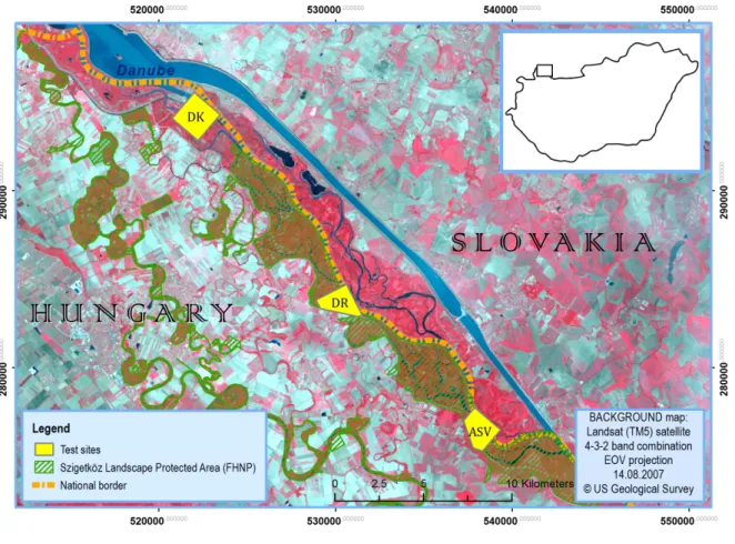
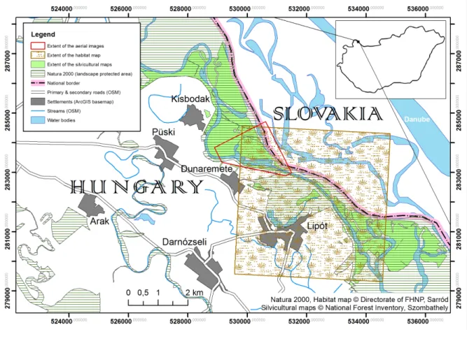
The present study is focusing on a Hungarian Danubian floodplain ecosystem: the Szigetköz wetland which is located in Northwest Hungary, in the interfluve of the Danube and Mosoni Danube rivers (Figure3.1). This floodplain together with the Slovakian Csallóköz is the most extended riparian wetland in the Upper-Danube region characterized by high biodiversity (Illés and Szabados,2008;Smith et al.,2000). The Szigetköz covers an area of approximately 375 km2, its length is about 50 km with an average width of 7 km, however, the regularly inundated area is much smaller. A part of that with around 9682 ha became landscape protected area in 1987 belonging to the Directorate of Fertő-Hanság National Park and nowadays including Natura 2000 SCI (sites of community interest), SPA (special protected area) and IBA (important bird areas)(Szabó,2005).
In the 19th century significant environmental changes occurred due to the regularization of rivers, which meant that at the end of the century most of the forests on the protected side of the dams were felled and replaced by arable land, hay meadows and pastures (Hahn et al., 2011). In 1992 further changes have happened in the region with severe impact due to the Danube-diversion, conveying approximately 80% of the discharge into the 29 km long bypass canal of the Gabčikovo Hydropower Plant in Slovakia, between Dunacsúny and Szap (Ijjas et al., 2010). The changed flow and sediment regime has significantly affected the unique diverse pattern of habitat types, which have been altered from aquatic or aquatic-related forms to more terrestrial species (Ijjas et al.,2010). Dried out river branches with a general
15
Chapter 3. Materials 16 decrease in ground water level characterized the changed environment in the Szigetköz, however, the degree of ground water level change have been influenced by the location and the actual amount of water in the Danube (Hahn et al.,2011).
Water was one of the main landscape-forming factors in the Szigetköz by playing a key role in building and maintaining a highly diverse terrain. Most of the continuously carried plant propagules from the Alps established and colonized the slow water tributaries of the Szigetköz. The limitation of the dispersal of propagules by water negatively influences the share of montane species in the flora. Contrary to the general drying of the environment nowadays, regular flooding not only provided favourable water supply, but brought exter- nal nutrients into the soil and prevented intolerant terrestrial species establishing on the floodplain (Hahn et al.,2011).
3.1.1 Effects of hydrological changes on the vegetation
The unique value of vegetation in the region refers to the richness of species compositions, where montane and lowland species often grow next to each other. Before the Danube- diversion, 1013 vascular plant species were known to occur in the Szigetköz, which comprises 46% of the total vascular flora of Hungary (Hahn et al., 2011). As it has been mentioned before, areas beyond flood protection dikes are covered mostly by arable land, while forests and meadows are present in the inundation region. Native forests appear particularly on small islands. On the lower wetland sites patches of the original reed, marsh or tall sedge vegetation are preserved, which react to the water regime modifications much faster than forests, due to their shallower rooting depths. Forests in the Szigetköz have nationwide significance and especially high natural value in the field of nature conservation concerning the problem of alien species spread in softwood gallery forests (Hahn et al.,2011).
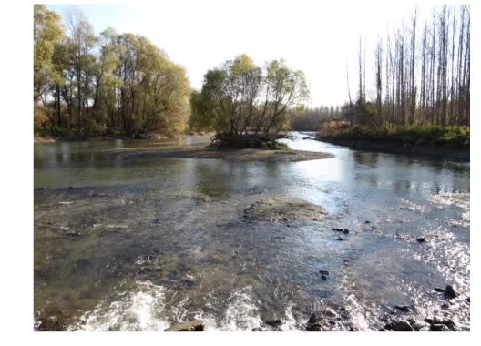
The state of naturalness varies at the different parts of the Szigetköz, ranging from com- pletely anthropogenic agricultural fields to natural plant communities worth of special pro- tection (Simon et al.,1993). However, due to the higher proportion of alien species in the softwood (willow-poplar) gallery forests (Figure3.2) the degree of naturalness is lower here than in the hardwood forests (oak-elm-ash). Softwood gallery forests are rich in soil nutri- ents and receiving floods frequently which provide better habitat for nutrient demanding invasive species. Nevertheless, the naturalness of species composition for almost each layer is higher in the Szigetköz than elsewhere in the country due to the lower proportion of alien
Figure 3.1: Map of the Szigetköz Danubian floodplain. Subset from the map of Győr- Moson-Sopron (Hungary), by Imre Bába (Paulus Mapdesign Office).
species, higher amount of natural accompanying species and the lower predominance of dis- turbance tolerant species. By the abundance of old trees and the amount of dead wood the value of naturalness is greatly improved as well. In addition to that softwood gallery forests are favoured nesting sites for large-bodied birds (Hahn et al.,2011).
After the Danube-alteration, a water recharging system provides the water in the Old- Danube channel and side arms, which is artificially regulated. The Danube diversion effected the various forest communities differently, whereby the most severe influences revealed on the low floodplain, where the sharp drop in the gradient in the depth of groundwater (Vek- erdy and Meijerink,1998) had a serious impact on forests near to the main Danube riverbed.
Chapter 3. Materials 18
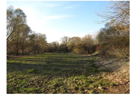
Figure 3.2: Willow (on the left) and hybrid poplar forests (on the right-hand side) in the Szigetköz, near to Gombócos. The photo has been taken on the field work (06.11.2010).
Despite increasing water levels in the tributaries due to the bottom dike, with the current water recharge system it is not possible to simulate floods. Related to the missing inunda- tions vegetation undergoes significant changes and hereby loses its special character (Hahn et al.,2011).
3.1.2 Botanical mapping
History of botanical surveying
The report of Zólyomi (1937) described that the phytocoenological survey of forest com- munities started in the late 1920s and provided detailed descriptions of willow woods, oak hardwood gallery forests, relict oak-hornbeam woods and swamp alder woods, where the for- est stands were considered as remnants of former extensive natural woodlands. Regarding the proportion of forests to fields it was 60 to 40 in the 1920s (where hybrid poplar planta- tions accounted for 12.5% of forest area), nevertheless, it went through a remarkable change with the extension of agricultural land until the 1980s, which means that the mentioned ratio became 20 to 80. The share of hybrid poplar plantations within forests increased as well to 81% by that time, whilst seminatural forests covered 19% of the area only (Hahn et al.,2011).
Recent surveying methods
In 1997 a new national project, the National Biodiversity Monitoring System (Hu. NBmR:
Nemzeti Biodiverzitás-monitorozó Rendszer) has been started in its test phase defining 124 squares of 5×5 km2 (covering around 3.2% of Hungary), where the habitats are classified after the so-called Á-NÉR classification system at the scale of 1:25 000 (Török et al.,2007).
The Á-NÉR (Hu. Általános Nemzeti Élőhelyosztályozási Rendszer) Hungarian habitat map- ping method concentrates on the joint observation of physiognomy, species composition, vegetation dynamics and habitat quality based on naturalness in its non-hierarchical, two- dimensional (including vegetation type and habitat quality) categorization (Bölöni et al., 2008). The scale (1:25 000) and the number of categories (116) were both exceeded the CORINE Land Cover classification system (with the scale of 1:100 000 and 44 categories in total: http://www.eea.europa.eu/publications/COR0-landcover) and were less than the traditional vegetation mapping system (current phytocoenology applies the scale of 1:10 000 - 1:5 000 and maps beyond 400 classes)(Fekete et al., 1997). This type of biodi- versity monitoring aims at the characterization of a concrete site, also in comparison with other sites and analysing changes for the certain test area.
Questions and uncertainties
Botanical mapping has a subjective nature, since it depends much on the surveyor’s map- ping concepts and experiences, therefore, the current surveyors have to take into account carefully how their predecessors had mapped the area (Takács and Molnár,2009). During the mapping of thematic data, e.g., vegetation habitats without administrative borders, it is a common question, whether we are able to do hard or smooth classification regarding the vegetation boundaries, where the geometric resolution and the definition of target classes play an essential role.
Considering the “classification rule” of the botanists (e.g., Á-NÉR), there are some classes where the distinction or delimitation between them is very difficult and subjective to the botanist’s personal judgement. Examples are spontaneous successions, e.g., distinction be- tween riverine willow shrubs (“J3” code in Á-NÉR) and willow mire shrubs (“J1a” in Á-NÉR, generally Salix cinerea).
Chapter 3. Materials 20 3.1.3 Remote sensing analysis
Medium resolution Landsat satellite image analysis showed a decrease in the normalized difference vegetation index in short-term (1992-1993) (Smith et al.,2000), which was caused by dropping groundwater levels, documented and modelled in the region, e.g., by Vekerdy and Meijerink(1998). Similarly to that, negative changes were detected in the wetness values based on the Tasseled Cap transformation of Landsat, however, from 1997 a continuous regeneration is experienced, except for older willow species (Kristóf,2005).
Focusing on detailed vegetation analysis, advanced image interpretation techniques have been commonly applied to remote sensing studies in the recent years (Blaschke et al.,2011), however, in the test site of the current research, botanical vegetation habitat classifications have been mostly based on traditional field surveying. Available aerial imagery was often used as unprocessed background information for visualisation purposes as a basic background layer for field work and for vector data representation (Takács and Molnár, 2009). Land use/land cover classification of the floodplain has been primarily based on visual image interpretation (Licskó,2002), however, the different types of vegetation habitats, which are in focus in the botanical analysis, have not been considered there.
The monitoring of forest ecosystems in the Szigetköz has been undertaken by the Forest Re- search Institute (ERTI, Budapest) since 1986, also as a member of the Szigetköz Research Group (in the Hungarian Academy of Sciences) from 1995 (Illés and Szabados,2008). For- est health status and its changes as an important indicator after tree growth rate on the dramatically changed hydrological situation has been analysed by digital image process- ing algorithms (pixel-based supervised image classification techniques) in the study ofIllés and Somogyi (2005), where the analysis was applied to different forest types based on or- thophotos from 1991 and 1999. Despite some promising results, health status could not be estimated for certain species. Another silvicultural study (ERTI, 2008) has concentrated on the detection of leaf losses based on CIR aerial image (2008, 1 m/pixel, from VITUKI Environmental Protection and Water Management Research Institute, Budapest). Though unreliability has been demonstrated by the false inclusion of shadowy areas into the leaf loss classes, it has been obvious that the region of Dunakiliti, Kisbodak and Lipót gave worse values for leaf loss in comparison to the southern part where the water-recharging system and the thicker sediment layer provide better conditions for the forests. Recently in the frame of a Hungarian-Slovakian Cross-border Cooperation Programme (2007-2013,
INMEIN,“Innovative methods for monitoring and inventory of Danube floodplain forests based on 3D technologies of remote sensing”) the analysis of airborne laser scanning data gave promising results for forest inventory (Király and Brolly,2013).
3.2 Applied imagery
Aerial imagery was acquired for the present research over three test sites near to the vil- lages Dunakiliti (DK), Dunaremete (DR) and Ásványráró (ASV)(Figure 3.3) in order to study an area where the data of the most recent (2004) botanical survey is accessible (Dunaremete) and other two sites, Dunakiliti, situated nearest to the Danube-diversion point and Ásványráró, where the water-recharging system has a great influence. Digital or- thophotos from 2000, 2005 and 2008 are available at the Institute of Geodesy, Cartography and Remote Sensing (FÖMI, Budapest).
Figure 3.3: Test sites in the Szigetköz Danubian floodplain
In 1999 the University of West Hungary (UWH) was involved in a Phare Cross-Border- Cooperation (CBC) Project (Márkus et al., 1999), where aerial imagery was provided by
Chapter 3. Materials 22 Eurosense (http://www.eurosense.com) and this aerial image material could be accessed and applied to the current research. Since this data set consisted of CIR images, it was selected for the analysis instead of the FÖMI orthophotos of 2000, which were RGB images.
Digital (respectively digitalized) orthophotos directly used in the study with the basic pa- rameters are summarized in Table 3.1. In Appendix A we can find the images themselves for the test site of Dunaremete in smaller format.
Table 3.1: Detailed information on the orthophotos used in the research. *Because of the digital camera in case of 2008, the given scale cannot be directly compared to the others.
Orthophotos 2008 2005 1999
Source FÖMI, Budapest FÖMI, Budapest UWH, Phare CBC Project
Scale 1 : 74 000* 1 : 30 000 1 : 30 000
Geometric resolution 0.5 m/pixel 0.5 m/pixel 1.25 m/pixel Applied recording type Digital,CIR Film,True Colour Film,CIR
Spectral resolution NIR, G, B RGB NIR, R, G
Camera type UltraCamX Wild RC 20 Wild RC 20
Acquisition time 06.08.2008 29.07.2005 03.08.1999
Solar azimuth angle 125.6◦ 209.4◦ 111.6◦
3.3 Botanical and silvicultural maps
Classified maps based on remotely sensed data always need verification by ground reference information. After the study of the Environmental Laboratory (1987) field wetland identi- fication requires the observation of three wetland parameters: hydric soils, hydrology and hydrophytic vegetation. However, in this study vegetation data (silvicultural and botanical) was used as an integrator of these wetland parameters.
In the present study thematic maps as reference data have aided the interpretation and classification of the aerial image scenes. Because of the difference between the image acqui- sition times and the field surveys (in the case of the vegetation habitat maps and the forest inventory data as well), their application has been done with careful considerations.
The selection of the Dunaremete test site, as principal study area, has been directly influ- enced by the location of detailed botanical investigations in the floodplain (see the over- lapping areas in Figure 5.1). The square test site of botanical investigations (habitat map in Figure 5.1) has been stated as a good representation about its surroundings, too. The vegetation along the Danube is very similar to it regarding the hybrid poplar and willow
plantations and the near-natural woodlands between the dam and the river (Takács and Keszei, 2004), where the Á-NÉR classification system (Chapter 3.1.2) has been applied.
These maps are available from 2004 and 2000 (Appendix B), covering an area of 25 km2 with the scale of 1:12 500, where the accuracy of the separation between different vegetation habitats is around 10 m.
Whilst habitat maps from botanical inventory emphasize physiognomical aspects and vegeta- tion dynamics in their classification system (Bölöni et al.,2008), silvicultural maps include forest categorisation, where the concrete species are described. Detailed information on forests at a scale of 1:10 000 (related to 2010) has been provided by the National Forest Inventory (NFI), Szombathely. Regarding the digital silvicultural database the original ac- quisition year was 2003, however, it has been continuously updated after field inspections.
In AppendixBthe delineation of the silvicultural classes (Forest Stand Type, inhu. FATI1:
1. Faállomány Típusa) is presented and marked on the 2008 orthophoto (FigureB.3).
Chapter 4
Methods
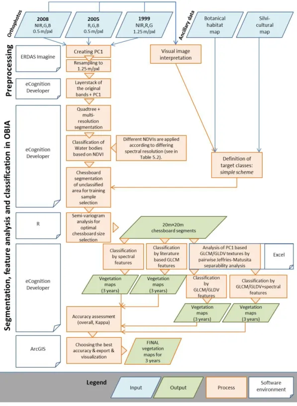
The detailed analysis (Chapter5and Chapter6) of the data set was based on digital image analysis techniques presented in the current chapter. Chapter4.1is focusing on segmentation techniques as the first step in object-based image analysis (OBIA), followed by the spectral and geostatistical characterization (Chapter 4.2, Chapter 4.3). The significance of class separability analysis is described in Chapter4.4. Chapter 4.5is introducing the supervised classification algorithms applied. The closing section (Chapter 4.6) deals with the accuracy assessment as a crucial part of any classification approaches.
4.1 Image segmentation
The first step of the object-based image analysis is the application of segmentation, where a combined use of spectral and spatial patterns is normally built into the analysis (Lillesand et al.,2008). The three main types of segmentation are: pixel- or histogram-based (involv- ing only spectral characteristics), edge-based (looking for edges which separate homogeneous objects) and region-based, which could have three sub-types: region growth, region merging and region splitting algorithm (Lang et al., 2006). The region-based technique also called as surface(-based) segmentation is probably the most well-known type, where the simplest application is the quadtree segmentation approach based on the splitting of the image into 4 parts firstly and with the use of a homogeneity measure for each segment further splitting and merging is applied (Barsi,2013). Another important segmentation technique, the multi- resolution segmentation approach (defined in the eCognition software environment) belongs
24