Mars-Relevant Field Experiences in Morocco:
The Importance of Spatial Scales and Subsurface Exploration
Akos Kereszturi,1Zsuzsanna Kapui,2 Gian Gabrielle Ori,3,4Kamal Taj-Eddine,3and Gabor Ujvari2
Abstract
During field work at the Ibn Battuta Mars analogue sites, two research questions were analyzed: (1) How do we identify sampling sites using remote and local imaging and (2) what kind of information can be gained from shallow subsurface exploration? While remote images help in targeting field activities in general, the con- nection between observations at different spatial scales for different rocky desert terrain types is not well established; in this, focused comparison of remote
in situimages of well-selected analogues would help a great deal. Dried up lake beds as discerned in remotely acquired data may not show signatures of past water activity, while shallow subsurface exploration could reveal the lacustrine period. Acquisition of several satellite images of the same terrain under different geometries would help to support the planning of such
in situwork. The selection of appropriate sampling sites in fluvial settings could be improved by analyzing long, meter-high, open-air outcrops that formed during most recent fluvial episodes. Such settings are abundant on Earth and could be present on Mars but may be just below the resolution of available data. By using 20–30-cm-deep excavations, shallow subsurface exploration could reveal the last period of geological history that would have been unattainable by surface observation alone. Aggregates embedded in the original strata or from heavily pulverized samples could not be identified; only weakly fragmented samples viewed right after acquisition showed aggregates, and thus, the close-up imager (CLUPI) on the ExoMover might provide information on cementation-related aggregation on the observing plate before crushing. The mechanical separation of different size grains (mainly clays and attached minerals) would also support the identification of individual components.
To maximize context information during subsurface exploration, rover imaging should be accomplished before crushing; however, currently planned imaging may not be ideal for this. Key Words: Mars analogues—Ibn Battuta Centre—Subsurface exploration—Field work. Astrobiology 18, xxx–xxx.
1. Introduction
M
ars analogue studieson Earth support the planning (Balivaet al., 1999; Farr et al., 2002; Berczi et al., 2007; Hargitai, 2009; Orzechowskaet al., 2011; Orgelet al., 2014; Amadoret al., 2015), testing (Groemeret al., 2010, 2014; Losiaket al.2014), and realization of Mars missions (Golombek and Rapp, 1997), and help to widen and deepen our understanding of various processes and conditions beyond Earth (Barlowet al.,2011; El-Baz et al., 1979; Wentworth et al., 2005; Warren-Rhodeset al., 2007; Catlinget al., 2010;Hesse, 2012). Among these field sites, accessible desert ana- logues (Komatsuet al., 2007; Oriet al., 2014b) provide ideal
locations for the preparation and testing of methodologies of planetary surface exploration. In the present study, we sum- marize field experiences at the Ibn Battuta Mars analogue field sites in Morocco, with emphasis on the next European Mars surface mission: the ExoMars rover (Vago and Exomars Pro- ject Team, 2010; Vago et al., 2015). Thus, we place more emphasis on methodological means as opposed to resolution of scientific issues.
This work focuses on two main research questions: (1) How to improve the targeting ofin situwork by using dif- ferent spatial-scale information, including remote sensing and local nearby images? The underlying hypothesis is that the proper interpretation of outcrops and understanding of
1Konkoly Thege Miklos Astronomical Institute, Research Centre for Astronomy and Earth Sciences, Budapest, Hungary.
2Institute for Geological and Geochemical Research, Research Centre for Astronomy and Earth Sciences, Budapest, Hungary.
3Ibn Battuta Centre, Cadi Ayyad University, Marrakech, Morocco.
4International Research School on Planetary Sciences, Pescara, Italy.
ªMary Ann Liebert, Inc.
DOI: 10.1089/ast.2017.1676
1
the local geology maximize the outcome from laboratory- based sample analysis. (2) What type of information could be gained by shallow subsurface exploration on Mars at ana- logue sites? Forthcoming Mars missions will use drilling and subsurface sampling (to avoid the weathering effect of solar ultraviolet, atmospheric oxidants, and partly ionizing particle radiation at the surface), which will include ExoMars rover drilling. However, it is not yet fully understood how fruitful subsurface sampling on Mars will be or what characteristic settings will be revealed in the shallow subsurface. It is possible that, due to the slow rate of surface weathering and erosion on Mars, some geological settings in the subsurface are well preserved, in particular older sedimentary terrains. It would be advantageous, however, to demonstrate subsurface exploration procedures by investigating analogue sites in slowly changing terrestrial desert regions.
Furthermore, a general field exploration was also done with an emphasis on methodological issues, including questions as to whether any differences existed betweenin situand satellite-based remote image analysis of Mars-like terrains in the study area, and how the different spatial-scale observations can be integrated and fit into a general picture.
The expedition crossing the Atlas and Anti-Atlas was re- alized between 15 and 21 of September 2016 with the support of the Europlanet RI H2020 project. The Ibn Battuta Centre as a facility of the Europlanet Research Infrastructure was established in 2006 by the International Research School of Planetary Sciences (IRSPS) at Pescara, Italy, to prepare and execute scientific analogue field tests of various instruments and methods for missions to Mars and partly to the Moon (Ori et al., 2015). Descriptions of the major characteristics of these sites and the already realized projects there can be found in accompanying articles of this special issue and in previous publications (Oriet al., 2009, 2011, 2013).
Ibn Battuta is specific among other Mars analogue sites in a sense that there are a large number of different sedimen- tary environments and sediment types in the region, which experienced substantial climatic changes in the last million years that included dry and wet periods (Oriet al., 2014a).
Among these environments, recent wadis (Nicoll and Ko- matsu, 1999) and different stony desert types with large morphological varieties occur. The martian surface is often characterized by quite a large number of boulders of dif- ferent sizes (McSweenet al., 1999) together with dust and duricrust covered surface units. The spatial distribution of boulders is partly related to local outcrops based on the observations of the Opportunity rover (Weitzet al., 2006), and aside from impact ejection, weathering has likely con- tributed to the production of surface debris cover on Mars.
The terrains at Ibn Battuta Centre provide ideal conditions to gain insight into the formation of these rock deserts and determine the methodological requirements for analyzing such aeolian surface features on Mars.
In the present study, we provide examples on how the geological/morphological features should be analyzed on different spatial scales ( Jolliffet al., 2002) and discuss how the sampling of targets on Mars should be performed. We also put emphasis on the shallow subsurface region (down to 10–30 cm), as this depth is getting more accessible by present and future missions (Kereszturi, 2012). In this study, a great step forward is expected from drilling activities of the ESA- IKI (European Space Agency—Russian Space Research In-
stitute) ExoMars 2018 rover (EXM) missions and from the ground penetrating radar and neutron spectrometer onboard ExoMars that have the capability to survey the shallow sub- surface down to about 2 m depth. This analogue research work is the continuation of an earlier attempt (Kereszturi et al., 2016) to identify what type of geological and past water-related information could be gained by EXM using analogue observations. Understanding the geological history will be crucial to proper planning and the overall focus ofin situ research in astrobiology on Mars, including reconstruc- tion of past conditions and the identification of the role of water. Earth analogue studies, in particular, will provide crucial information for future endeavors on (Rothschild, 1990; McKay et al., 2002; Cabrolet al., 2007; Hocket al., 2007; Preston and Dartnell, 2014).
2. Methods
The field work in Morocco was supported by the Ibn Battuta Centre and included travel by way of two jeeps, on and off road, with GPS coordinates. During the field activ- ities, cameras, hammers, spades, and a hand driller were used. The activity started with satellite image analyses and continued in the field with a rough characterization (short visual inspection) on-site. If a particular geological site proved to be attractive (observable surface features that would provide insight into past formation processes such as layering or signatures of liquid water or other transport processes), a detailed workup was initiated, which included photo documentation at different spatial scales (from con- text to small-scale sedimentary features), excavation and profile cleaning of outcrops with spade shovels, drilling (at four sites altogether) and optical scanning of borehole-walls with an A4-Tech PK-910H web camera, and finally, sam- pling of the drilled subsurface material for subsequent lab- oratory analyses. The maximal resolution of the A4-Tech PK-910H camera is*0.1 mm, while the maximal resolution of the close-up imager (CLUPI) onboard ExoMars will ideally have about 0.01 mm spatial resolution. However, the real spatial resolution might be lower, and thus, our field tests provide a conservative approach as to what CLUPI will be able to identify.
The collected samples were analyzed in the laboratory at the home institute with a NICON Eclipse E600 POL microscope with a capability of 4·, 10·, 20·, and 40· magnification.
Further analyses with infrared (IR) and Raman spectroscopic methods, as well as particle morphological studies, are ongo- ing and will be detailed in future articles. Methodological re- sults could be gained by comparing two types of images:
Remote sensing images of Google Maps with 0.3 and 2.0 m spatial resolution, which are somewhat lower than the maxi- mal resolution HiRISE images of the martian surface with 0.25 m. The other type of images are on-site photos with res- olution of 0.1–0.5 m/pixel, which is comparable to the Pa- noramic Camera’s (PanCam) resolution onboard EXM as recorded from several meters’ distance.
3. Results
Field work was performed over the course of 5 days in the field along the Marrakech-Ouarzazate-Erfoud-Zagora- Ouarzazate-Marrakech route (850 km) (Fig. 1). Image and sample acquisitions were acquired at 70 field stops, some of
2 KERESZTURI ET AL.
which were associated with drilling activities. Below, we have included an overview that focuses on how these ana- logue sites would be investigated so as to support planning for field work on Mars with a special emphasis on geolog- ical observations at different spatial scales. We also outline our overall findings and observations as they apply from larger to smaller spatial scales, that is, from satellite images to those acquired at the microscopic level.
3.1. Comparison of remote sensing versus in situobservations
Various surface features characteristic of desert land- scapes (Garvin et al., 1981; Christensen, 1986; Golombek and Rapp, 1997; Levyet al., 2009) were recorded on-site as panoramic photos and were then compared with satellite images. The observed surface features were grouped in such a way as to reveal similarities and differences between the two image types to improve interpretations when using satellite images (such information is exclusively used for landing site selection on Mars; Bridges et al., 2003; Ar- vidsonet al., 2008). We also sought to estimate how far we could extrapolate by using remotely visible structures below the spatial resolution of remote data. For example, how would the presence of structures below the spatial resolution be detected by using the remote data available. The analyzed surface features at the Ibn Battuta field sites were classified into groups termed cliffs (<100 m diameter, isolated and elevated rock exposures), hills (>100 m diameter elevated structures), general rocky desert (reg) surfaces with scat- tered rock blocks and/or gravel, general sandy desert sur- faces with sand dunes (ergs or sand seas), lakes, wadis, and transition zones between each characteristically different surface texture areas (Mabbutt 1977).
Characteristic image pairs of remote sensing-based and in siturecorded surface features are seen in Figure 2. By analyzing these images, the following features are visible (coordinates are given in brackets at the end of each subset caption below).
In Figure 2a, cliffs (1 in Fig. 2a) could only occasionally be identified in remote sensing images due to illumination
geometry that casts shadows and thereby hinders recogni- tion. Shadows might infer the existence of natural outcrops and could be used together with regional geological context to identify proper locations in vertical strata for on-site analysis. The joint use of remote sensing images and on-site photos helps to link the collected samples to regional-scale geological units (31.430361 N,-4.303556 W; Google Maps coordinates).
In Figure 2b, illumination created brightness differences between dunes and their subunits (1 in Fig. 2b); dark surface gravel cover (2 in Fig. 2b) and bright underlying evaporites can be easily recognized in satellite images. Due to the dark gravel surface that overlies evaporites, however, the iden- tification of stratigraphy requiredin situfield work. Spatial arrangement, including stripe-like features at the edges of the dark area, can roughly be identified in the satellite im- ages (31.193278 N, -4.109361 W), but the origin may be diverse and unidentifiable in remote sensing images only.
In Figure 2c, large, tilted bedrock layers are easily recog- nizable in this image due to their different albedos (1 and 2 in Fig. 2c). Although a sampling may seem to be identifiable with remote sensing data, the proper sampling point to be selected requires further analyses at higher resolution (1–10 m scale) images (31.008889 N,-7.102444 W).
In Figure 2d, steep edges (1 and 2 in Fig. 2d) of ephemeral river (wadi) banks form outcrops and can be spotted on images taken only under proper illumination conditions (31.040806 N, -7.124944 W).
In Figure 2e, linear dunes, barchans (1 and 2 in Fig. 2e), and sharp contact lines between dune sand and bedrock material are clearly visible on remote sensing images. These image pairs demonstrate that substantial albedo differences help to identify ideal locations for in situ work (31.280222 N, -3.989361 W).
In Figure 2f, sharp contact lines (1 in Fig. 2f) between dune fields; dune-free, deflation surfaces; and large star dunes (2 in Fig. 2f) can be recognized in this image (31.211028 N, -3.999667 W).
In Figure 2g, strong albedo differences are visible in these image pairs between dark basaltic rocks (1 in Fig. 2g) and FIG. 1. The route of the expedition with the locations of those stops, which are also indicated in the tables of this article.
FIG.2.ExamplesfortheGoogleEarth-basedremote(1and3columns)andinsiturecorded(2and4columns)imagepairs.Imageinsetsaremarkedwithlettersandtheimage numbersofvisitedlocationsinbracketbehind.Numberedarrowsmarkthesamefeatureobservableonimagepairs.Moredetailscanbereadinthe3.1section.
4
yellowish-reddish carbonates (2 in Fig. 2g), which are em- phasized by mass wasting (3 in Fig. 2g) from local heights (31.450167 N, -5.665667 W) and transport of the darker material onto the brighter carbonates.
In Figure 2h, outcrops of horizontal layers characterized by different albedos (1 in Fig. 2h) form a horizontally stratified hill (2 in Fig. 2h) (31.167472 N,-7.472917 W).
In Figure 2i, hills of different heights and slope exposure (1–3 in Fig. 2i) are present as barely observable structures in remote sensing images, demonstrating the importance of geometric conditions for satellite image acquisition (31.547639 N, -4.881556 W).
In Figure 2j, rock layers with their vertical outcrop walls and sharp edges (1–3 in Fig. 2j) emerge in this photo and the identification is aided by shadow, useful for locating sites where the vertical strata could be analyzed (31.297944 N, -4.402556 W).
In Figure 2k, typical reg (specific desert type) surface with reddish clayey and iron oxide-coated material in be- tween blocks (30.748389 N, -6.68625 W).
In Figure 2l, typical reg surface differing from Figure 2k in boulder and gravel sizes and color, where ephemeral fluvial channels are obvious on satellite images (30.780417 N, -6.661861 W).
The analyzed terrain types at Ibn Battuta analogue fields were often sedimentary in origin, including old and recent ones, occasionally with ongoing fluvial and/or aeolian for- mation processes. As sedimentary successions and often water-related terrains will be targeted in future Mars mis- sions (Doranet al., 1998; Peeterset al., 2009; Coradini and Orosei, 2011), we emphasize on the analysis of features of various sediment deposition mechanisms. Changes in the environmental parameters during deposition could directly be observed in the strata (thickness, lithology, mineralogy), which are obviously rarely seen in satellite images due to viewing geometry and limited spatial resolution. However, several sedimentary patterns/structures could be identified on satellite images, too.
Debris flows (talus slopes) can be observed in many pictures, both on the satellite and on-site images. The shape and exact size can be estimated by using satellite pictures for structures>100 m in size, as the whole structure cannot be seen in the field. Their occurrence is indicative of erod- ible bedrock affected by mass wasting due to mainly me- chanical weathering and erosion. In situ analysis could highlight the type of the mass wasted sediments, the thick- ness, grading, and sorting, and improve our understanding of the transport process.
Two basic types of deserts are present in Morocco among the Ibn Battuta sites: stone deserts and sandy deserts (regs and ergs). It is well known that the approximate size of large rock blocks can be discerned with the use of satellite im- ages, while in situ images allow for determination of li- thology sorting and dune size within sand features and varying sized gravel and pebbles. Based on a local in situ survey, the stone deserts show local diversity (rock type, pebble/gravel size, occurrence), and their satellite images reveal a diverse number of features. No connection, to date, has been made between the appearance of a given rock desert type in remote sensing data and appearance inin situ images, which might be an important topic for future research.
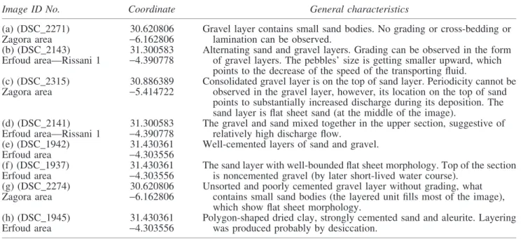
In some cases, dried lake beds can be identified in satellite images when aided by recognition of feeding channels and bright evaporites that were left behind after an active period.
Nevertheless, sensing data acquired remotely have proven not to be sufficient for sure such identification. A smooth depositional area in remotely acquired images does not necessarily indicate a former lake bed. Images taken on-site, however, can provide further clues, in particular when the former lake bed is indiscernible due to cover such as (1) wind transported dust, (2) clay layers (without bright evap- orites), or (3) rock fragments and gravels entrained by areal flash floods, leading to a dark surface appearance when viewed from above (see the example in Section 3.2.1 later).
The sediment types (clay, evaporite, sand) and their relative location to each other in the Ibn Battuta region allowed for determination of the stratigraphy duringin situanalysis and confirmation of the existence of former lakes. On Mars, former lake beds are often identified by their bank structures and feeding channels (Cabrol and Grin, 1999; Fassett and Head, 2008), but it should be noted that other lines of evi- dence will be needed for future missions to successfully identify lake bed features.
A comparison ofin situ and satellite-based observations on different surface structures is summarized in Table 1, focusing on consequences for surface exploration.
Based on the general characteristics outlined in Table 1, satellite images support the identification of surface areas covered by the investigated structures, aid in route planning, support rough target identification and estimation of po- tential source regions of surface debris, and generally pro- vide useful context for in situ work. By contrast, local images allow for constraining formation mechanisms, pro- vide a record for temporal changes in the sedimentary environment, and aid in identification of compositional/
lithological characteristics of source regions. These con- siderations highlight the importance of acquiring local im- ages of outcrops and surface structures before sampling, which, together with satellite images, would provide the proper context for interpretation of sample analysis results.
3.2. The shallow subsurface zone
During the Mars analogue field work in Morocco, we tested how the shallow subsurface exploration could con- tribute to understanding the formation of the region: espe- cially what type of Mars-relevant information could be gained with a 10–30-cm-deep pit excavated at the analogue field. The rationale behind such activity is to support the understanding of the formation of a given area and get field experience that supports the planning of forthcoming mis- sions. Few surface missions have had or will have such shallow subsurface exploration capabilities, such as the neutron spectrometer onboard Curiosity (Grotzinger et al., 2012) or WISDOM (Dorizonet al., 2016) and the driller (Di Iorio et al., 2012; Bost et al., 2015) onboard ExoMars.
Experiences related to this topic are fairly limited, and here we provide some general geological and methodological lessons learned at Mars analogue sites.
Natural outcrops reveal subsurface zones, but these are not necessarily abundant, especially at smooth terrains filled with sedimentary material. Numerous outcrops are expected at impact craters (Hynek, 2004; Clarket al., 2005); however,
Table1.OverviewofSimilarities,Differences,andRelationshipsFoundBetweenRemoteSensingandInSituImages SurfacefeaturetypeVisiblefeaturesonsatelliteimagesVisiblefeaturesoninsituimages HillTargetshapeat100mto1kmscale,indicatespossiblesitesforinsitu work,oftenappearstogetherwithdebrisslopes(>10msize),ridges,and layeroutcrops,largeblocksoftenclusteredaroundthefeetofthehills andonflathilltops/terrain-typeseparation,spatialdistributionofunits
Targetshapeat1–100mspatialscale(visibilityisrestrictedby viewingangle,butsupportstheidentificationofverticalstrata); thicknessoflayerscanbeidentified;debrisslopesdowntomsize scale;physicalaccessibilitycanbebetterestimated/recordof temporalchangesofdepositionalconditionsinstrata Sanddesert(erg)Bordersbetweendunesandbarrensurfacecouldbeeasilyidentifiedby albedo/colorchanges/routeplanningandsiteaccessestimation; shapesofdunes/windregime;surfacetexturecanbedifficultto estimateexceptsanddunes/furtherconstraintsareneededtoestimate on-siteworkingpossibilities
Identificationofsurfacematerial,rockdistribution/separation betweendominantformationagent(wind,masswasting,insitu weathering);bordersbetweendifferentsurfaceunitscanbe identifiedonlynearby(<10m),duneheights/volume estimation;samplingcertainunitsofdunes/particlesize differencesandaccumulationprocesses Stone-desertDifficulttoidentifysurfaceproperties(suchasaveragerocksizeandspatial density);arealdistributioncanbeoutlined,sourceoutcrops(ifany)could beidentified Detailedmorphologicalinformationofcolor,size,shape,roundness ofrocks/formationandtransportmethod;scaleinformationon thesiteaccess TransitionzonesEasilycouldbefollowedbyalbedoandcoloronlongerdistancethanbyin situanalysis/identificationrangeofsamplingpossibilities, identificationofideallocationsforstratigraphicanalysis
Couldbeinspectedathigherspatialresolutionbutatashorter distance;differencescouldbebetteridentified,including compositional,rockdensityorshape-orsize-relatedaspects/ estimationforstrategyofexplorationbasedonrelativeage differencesbetweenregionsincontact LakebedEdge,bank,feedingchannels,evaporites:directsignaturesforcontext identification/locatingthesiteswiththelongestperiodofwatercover; probablelakesiteidentificationfromcontext(withoutdirect signatures)/areastodrillandsample;contact(edge)ofunitscouldbe followed/keystratigraphicsitelocalization Color,composition,particlesizedifferences/formationmethods andregionaldifferences;desiccationpattern/confirmationof lacustrineperiods WadiErosionalchannel(occasionallybettervisiblethaninsituespeciallyin rockydesertareas),bars,fan-likesediments,braidingmorphology, terraces/supportinginformationtofindthegivenwadiinthefield
Mainchannelwall,bars/grainsize/maximalflowspeed;level ofbankfullstage/dischargeestimation;separationofdifferent sedimenttypes(depositedduringhighdischargeoutflow— moderatedischarge—ponding/flowhistoryreconstruction;size, shape,sorting,andimbricationofgravels/depositionconditions CliffLocationofmoreerosion-resistantlithology;althoughmanycliffsare obvious,thedirectionandtiltoftheirslopecanhardlybeestimated. Debrisslopesoftenoccuraroundcliffs,pointingtoongoingmass wastinganderosion Outcroplayeridentification<1mthickness,tiltandexposure measurement;compositional/lithologicalcomparisontonearby debris/sourceidentificationforblocksatthedesertterrain; verticalchangescanbeidentifiedinthestrata/ paleoenvironmentalchanges Arrowsindicatethepossibleusageandinferredinformationfromtheanalysisofgivenimagetypes.
6
other types such as on fluvial terrains can also be important and were analyzed at analogue terrains. All the examples presented in this study are images of natural outcrops (Fig. 3 and Table 2) that were related to fluvial terrains (wadis). In such valleys, branches that formed recently incised older sediments and uncovered the top 0.5–1.0 m section of the subsurface zone.
By pure surveying of channel walls (similar to those in Fig. 3), the recent geological evolution history of the given
fluvial terrain can roughly be estimated. This might have consequences on the planning of Mars exploration too, as the existence of outcrops requires relatively large, regional- scale surface structures that cut and expose subsurface features. Such large structures could be fluvial channels or tectonic faults at plains; however, hills could also expose their layers along steep walls. All the images in Figure 3 were recorded along 100–1000-m-long outcrops producing topographic undulations in branches, which formed at a
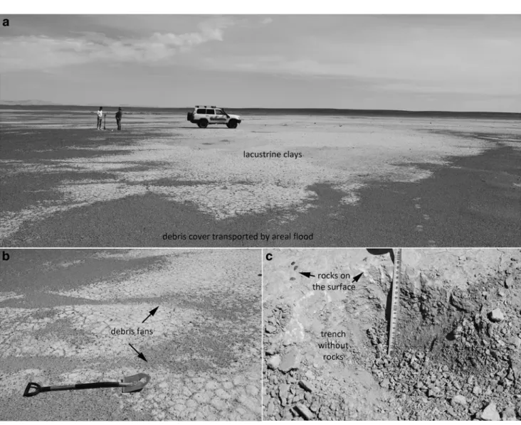
FIG. 3. Images of various fluvial processes related and by fluvial incut excavated natural outcrops. Periodic changes in deposited grain sizes(a–d), cemented gravel bar shielding the underlying deposits(e), fine laminated sand and aleurite size particles (f, g), desiccation produced laminated clays(h) could be seen on them. Most of the images show such fluvial stratigraphy, exhumed by later fluvial activities with deeper incut into earlier accumulated deposits. For specific details see Table 2 in Supporting Online Material.
later period of the fluvial activity, and they cut into the former deposited fluvial sediment at the same site of the same river.
As natural outcrops are rarely present on smooth terrains, artificial outcrops were excavated by spade and hand forced drillings to expose the subsurface sedimentary layers (see Table 3 for locations). To identify the sites for drilling, local geological context and existing natural outcrops nearby (if any) were considered, targeting usually at the deepest lo- cations of fluvial riverbed sample sites that experienced the longest and most recent periods of liquid water cover. For lacustrine environments, another approach was applied; lo- cations close to the bank of ephemeral lakes were sampled to have a stratigraphic sequence that includes fresh evapo- rites at the top, other lake bed sediments, and the bedrock
below to examine the whole stratigraphic sequence in its entirety thereby supporting comprehensive reconstructions of processes acting in this sedimentary environment.
The excavation sites displayed in Figure 4 targeted fluvial locations with fine sand (Fig. 4b); cobbles/gravels (Fig. 4b) where the particles’ size, layering, and imbrication could be easily analyzed. Former lakes (Fig. 4f) with sequences of sand, aleurite, and clay deposits were also analyzed; just like various rock desert types (Fig. 4a, c, e, g). Further details on these locations are found in Section 3.2.1 below.
3.2.1. Observing the shallow subsurface to identify the origin of rock debris. Based on some observations, even only a few cm deep subsurface excavations can provide such basic information that could not have been achieved otherwise by Table2. Supported Online Material: General Information
of the Natural Outcrops Indicated in Figure3
Image ID No. Coordinate General characteristics
(a) (DSC_2271) 30.620806 Gravel layer contains small sand bodies. No grading or cross-bedding or lamination can be observed.
Zagora area -6.162806
(b) (DSC_2143) 31.300583 Alternating sand and gravel layers. Grading can be observed in the form of gravel layers. The pebbles’ size is getting smaller upward, which points to the decrease of the speed of the transporting fluid.
Erfoud area—Rissani 1 -4.390778
(c) (DSC_2315) 30.886389 Consolidated gravel layer is on the top of sand layer. Periodicity cannot be observed in the gravel layer, however, its location on the top of sand points to substantially increased discharge during its deposition. The sand layer is flat sheet sand (at the middle of the image).
Zagora area -5.414722
(d) (DSC_2141) 31.300583 The gravel and sand mixed together in the upper section, suggestive of relatively high discharge flow.
Erfoud area—Rissani 1 -4.390778
(e) (DSC_1942) 31.430361 Well-cemented layers of sand and gravel.
Erfoud area -4.303556
(f) (DSC_1937) 31.430361 The sand layer with well-bounded flat sheet morphology. Top of the section is noncemented gravel (by later short-lived water course).
Erfoud area -4.303556
(g) (DSC_2274) 30.620806 Unsorted and poorly cemented gravel layer without grading, what contains small sand bodies (the layered unit fills most of the image), which show flat sheet morphology.
Zagora area -6.162806
(h) (DSC_1945) 31.430361 Polygon-shaped dried clay, strongly cemented sand and aleurite. Layering was produced probably by desiccation.
Erfoud area -4.303556
In the first column, the image identification number and the general name of the given terrain used by the Ibn Battuta Centre are written.
Table 3. Locations and Main Characteristics of Shallow Subsurface Stratigraphy (Images Can Be Seen in Fig. 4)
Image ID No. Coordinate Terrain type Main observations
(a) (DSC_2101) Erfoud area
31.193278 N Lake bed (dried up)
Reddish dark siliceous gravels in various sizes (1–10 cm) embedded in clay sediment.
4.109361 W (b) (DSC_1940)
Erfoud area
31.430361 N Wadi Dry (upper 5 cm) and wet sand in a wadi’s riverbed.
4.303556 W (c) (DSC_1755)
Ouarzazate area—ADAD
30.780417 N Stone desert Black and reddish-brown, variable size (1–50 cm) gravels among fine sand.
6.661861 W (d) (DSC_1690)
Ouarzazate area
30.963583 N Wadi Heterogeneous gravels (up to 40 cm) mixed with wet fine sand.
6.817722 W (e) (DSC_1715)
Ouarzazate area
30.963583 N Wadi Fine sand, wet around 0.5 m depth, mixed with heterogeneous (size, type) gravel.
6.817722 W (f) (DSC_2038)
Erfoud area—Chebbi
31.211028 N Lake bed (dried up)
Cyclic strata of sand/aleurite and clay (at around 28 and 42 cm), sandwiched by wet sand.
3.999667 W (g) (DSC_2156)
Erfoud area—Rissani 1
31.300583 N Lake bed (dried up)?
Clay and fine sand layers.
4.390778 W
8 KERESZTURI ET AL.
using only remote sensing-based observations. In the follow- ing, such examples are presented, being of high importance to Mars, and they also allow for improving research methods for coming missions.
The site No. 0203 (30.780417 N -6.661861 W, Ouarza- zate area—Adad) was a typical stony desert (reg type) with gravels/cobbles/boulders having different sizes (mostly 2–
30 cm) and shapes on the surface. (The terms ‘‘reg’’ or
‘‘serir’’ were originally used for stony desert surfaces cov- ered by sheets of gravel) (Thomas, 2016.) The blocks were mostly angular/subangular, originated from the same type, and did not show any imbrication or other regularity in their spatial arrangement. Generally, it is hypothesized that these desert surfaces formed by a combination of aeolian activity (deflation vs. dust deposition) (Cooke et al., 1993; Wells et al., 1995) andin situweathering from basement rock as the source material.
The 30-cm-deep excavation (Fig. 4a) revealed that there is no bedrock at this depth, which is what would have been expected for blocks produced by in situ weathering. Alto- gether, two trenches were deepened some meters away from
each other into the subsurface (down to 30 cm depth and at least 40 cm width), but neither of these exposed the bedrock.
The surface blocks varied in size between 1 and 25 cm;
some of them were relatively large and covered the surface almost homogeneously. The spatially homogeneous ar- rangement of gravels/cobbles and the lack of bedrock in the shallow subsurface led us to conclude that wind deflation and dust accretion, surface runoff, and/or lateral transport by creep (Cooke et al., 1993; Wells et al., 1995) are among those mechanisms shaping this landscape, while in situ weathering may safely be excluded.
The usefulness of simple shallow subsurface exploration is further demonstrated by another example, the homogeneous small particle debris field that remained at an ephemeral lake site after the active period (site No. 0403, coordinates 31.193278 N, -4.109361 W, Erfoud area) (Fig. 5). Here the surface debris resembles many other rocky desert surfaces: the terrain was covered by 1–2 cm diameter homogeneously distributed rectangular gravels. Some observations suggest that these grains were transported by areal floods; at the end of some small elongated depressions, these gravels were FIG. 4. Comparison of images of shallow subsurface exploration. The horizontal bars mark 10 cm length, relevant as scales around the middle of each image. More information on these locations can be found in Table 3 in the Image ID No. column.
accumulated in fan-like structures (Fig. 5b). Shallow sub- surface excavation (Fig. 5c) demonstrated that the debris is present only on the surface, while below, at least down to 20 cm depth, only fine material composed of silt/clay exists.
Thus, the rock debris was vertically unmixed with the aleurite–clay layer filling of the plain, but covered only the
surface of the fine material, pointing to the sequence of ac- cumulation events.
3.3. Drilling and borehole-wall scanning
Besides the inspection of natural or artificial outcrops, the shallow subsurface zone was explored by simple hand- FIG. 5. Dry clay-covered lake bed (bright)(a)with subsequent flash flood-transported small dark rocky debris(b)at site No. 0403, with no rocks in the shallow subsurface(c).
Table4. Basic Parameters for the Four Sites Drilled During the Expedition
Date (2016) Site ID No. Coordinates General description
September 16 02.02 3057¢48.9† Wadi, fine sand—0.4 m blocks, vertical (dm scale) and horizontal (10 m scale) heterogeneity (in particle size, shape, and rock type), wet at 0.5 m depth.
649¢03.8†
Ouarzazate area
September 16 02.05 3102¢31.7† Heterogeneous distribution of particles in large stripes.
706¢58.4†
Ouarzazate area—
Ben Haddou
September 17 03.02 3125¢49.3† Bottom of a wide wadi, heterogeneous at 10 m horizontal distance scale.
418¢12.8†
Erfoud area
September 20 06.01 3059¢2.6† Wadi, heterogeneous distribution (clay, fine gravel, bigger gravel), latter layers: white, evaporite, and brown clay.
79¢6.4†
10 KERESZTURI ET AL.
guided drilling (Table 4), accompanied with image acqui- sition of the borehole wall. More detailed analyses of the collected granular samples were planned to be performed in the laboratory of the home institute and this work is ongo- ing. The drilling activity was almost exclusively performed in wadis, where selection of a best site for sampling required a brief survey of exposed bank walls. Site selection always involved different spatial scales; it started with satellite image analyses at the landscape/landform scale (approxi- mately 102–103m), continued on-site at the local scale (100– 101 m), and finished at the scale of sedimentary features (approximately 10-1–10-3 m). An example sequence of analyzed scales by using this approach is presented in Fig- ure 6 (drilling site 0601).
In Figure 6, both the context (satellite images) and on-site images are presented for the fourth drilling site at 30.983 N, 7.151 W. The investigated structure is a 400–600-m-wide branching wadi that can be seen in Figure 6a and b.
Figure 6c–e displays a closer view of branches with dif- ferent surface debris cover, including exposed fluvial sedi- ments with gravel, sand, and aleurite–clay covers. Fluvial erosion resulted in natural outcrops, as floodwater cut into earlier deposited fluvial sediments, occasionally down to around 1 m depth. Topographic lows in channels produced during the last active fluvial episode were often filled with desiccated clay–evaporite layers and/or wind-driven sand accumulations. The fluvial and wind-driven fine material can be differentiated from ca 10–20 m distance on-site; a similar situation may be expected on Mars in exposed sur- face fluvial channels, and thus, a closer on-site inspection could be useful there.
Natural outcrops with fluvial sedimentary sequences can be seen in Figure 6h. Differences in bedding and grain size along the strata could be observed by inspection (from m to dm distances), which, although a trivial matter on Earth, would require time and effort to conduct a survey along outcrops during Mars exploration. This has been done a number of times with recent Mars missions; however, no sophisticated methodology has been developed as to how to conduct these surveys and optimize the number of nearby outcrops to visit. This context generation task could also be greatly improved by the use of drones (Singer, 2012;
Svendsenet al., 2013). Based on the field experiences, the layering structure, the existence of agglomerates, the oc- currence of larger grains could be enhanced by wind-driven selective erosion, and thus, such small-scale features could be easy to identify from open-air outcrops.
Using borehole-wall scanning in the drilled hole (Fig. 6g), images were acquired (Fig. 6i1–i5). While the contour of each particle could occasionally be blurred, individual grains above 0.2 mm diameter could firmly be identified. It is clearly visible that the larger grains are not rounded. The grain sur- faces look smooth, but this observation may be affected by the quality of pictures as these features are around the limit of spatial resolution. No structure or regularity can be seen in these borehole-wall images, despite the fact that layering was observed on the same sedimentary strata exposed at a nearby outcrop. However, it is worth mentioning here that particle size and the level of cementation were the main differences between the different layers, as opposed to albedo or color.
This implies that layering might be difficult to observe inside drilled boreholes on Mars.
The samples seem to be relatively well sorted (no more than two dominant particle size ranges are present: fine sand and aleurite), except those in the Figure 6i3 and i4. In these two cases, larger grains (>1 mm diameter) appear, and thus, these stratigraphic levels are less well sorted than the others, probably referring to higher energy transport conditions. Aggregates cannot be identified (they are present, however; see next paragraph), and the layering is almost invisible in the borehole-wall scanning compared with the outcrop wall.
The shape of the grains is similar in all samples acquired along the vertical strata; they are usually angular without sharp edges. In samples collected at 30 and 40 cm depths and close to the surface, the finest grains often stick to bigger grains to form aggregates. The aggregates from shallow (1 cm) depths are often cemented by evaporate minerals and clays that formed during the final stage of the wet period.
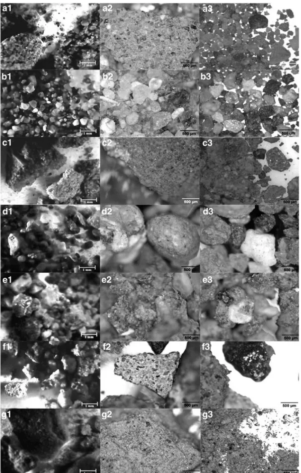
Higher quality laboratory images (Fig. 7) improved the information gained on particles. It is of note that images with similar resolution will be taken by the CLUPI camera onboard the EXM rover. Differences in image quality be- tween the images taken on-site and those recorded under ideal lighting and geometric conditions in the labora- tory are displayed in Figure 7, highlighting the importance of image acquisition conditions. This observation may have a methodological aspect for Mars exploration; quality of images to be recorded by CLUPI will likely be lower than determined during laboratory testing by MicrOmega (20·20mm).
The better quality of laboratory images resulted in im- proved size and shape determinations in the smaller size range (especially <0.2 mm), and more details of the grain surface patterns became visible. Among the minerals pres- ent, quartz, carbonate, mica, Fe-minerals, and some salt could be identified. The grains are more visible in the lab- oratory pictures, not just because of the better viewing ge- ometry but also because fewer aggregates were present as they fell apart during sampling and transport. Besides, ag- gregates were hardly visible while embedded in the sedi- ment matrix at their original location (wall scanning), but could be easily identified once the samples were collected and weakly pulverized due to simple transport. These ag- gregates were loose and easily fragmented, and the cement proved to be a mixture of iron oxides and clays.
The difference in characteristic grain size between sam- ples collected at various depths along the vertical sampling column could be easily seen both in the field and in the laboratory. Smaller particle size in the upper samples (Fig. 7A and B) (range: 100–200mm) and larger for the underlying horizons (Fig. 7C and D layers) (range: 800–
1500mm) imply decreasing sediment carrying capacity of a gradually weakened flow. The layer characterized by larger grain size may allow for estimation as to which sediments were laid down during elevated discharge. However, this analysis includes the data obtained in vertical strata of only one drilling. Open air natural outcrops offer a better over- view at more locations, however, and their analysis may allow a spatially better identification of the sediment layer associated with the peak discharge at a given area.
Evaporites and clays appear as cements between grains in Figure 7f and g insets. These samples provided many
FIG.6.Thepicturesfrom(a–f)showthelocationofthefourthdrillingsiteoftheexpedition(a,b)GoogleMapsandtheothers:localcameraimages;(g)thedrillingprocess; (h)theoutcropofthewallofthewadiwithdifferentlayers;(i)exampleimagesoftheboreholewallatdifferentdepths.
12
FIG. 7. Samples from 1, 4, 10, 30, and 40 cm depth (from the top row to the bottom, respectively). The last two rows show fragments (as agglomerates) of the evaporite and subsequently formed clay crust. The photos in the first column were made by A4-Tech PK-910H web camera. The pictures of second and third columns were made by NICON Eclipse E600 POL microscope in the laboratory. For the detailed explanation on the inset images see the description on section 3.3.
13
FIG. 8. The depositional areas of Oued Ziz (flow direction according to arrows) marked by the bright terrains in the middle(a). Wintertime ephemeral lake produced by rain provided discharge at the alluvial plain(b).
14
aggregates, and grains were attached stronger to each other than in other sampled layers. These cements may have formed after the termination of fluvial activity, during the desiccation phase when little liquid remained and finally evaporated.
4. Discussion
The major focus of this work is on the discussion of methodological issues relevant to the ExoMars mission as opposed to the sedimentary/facies interpretations. There- fore, in this section, the major findings are grouped into three topics, from the largest to the smallest spatial scales, and focus on their relationships to provide examples as to how the growing knowledge of information from different spatial scales can be connected to support the targeting of sampling. These include (1) the relationship between ob- servations at different spatial scales (m to km domain) to see what type of surface features are expected on Mars beyond the limit of resolution of orbiter images and how this in- formation could influence the planning of in situ sampling work), (2) the type of results that may arise from the anal- ysis of cm–mm scale observations during the shallow sub- surface exploration using field analogues related to former liquid water, and (3) results gained from the mm–mm scale observations of outcrops and drilled samples.
Regarding the comparison of satellite-based and on-site panoramic images, those features were separated that could, or could not, be observed on the remote sensing or in situ images. While remote sensing data effectively support the identification of sites characterized by large albedo differ- ences and/or sharp borderlines between various landforms, the appearance (and identification) of various slopes and vertical channels or exposed rock walls strongly depends on slope exposure and illumination angle. This points to the importance of acquiring several images from the same im- portant target site for Mars under different illumination and geometric conditions. This is somewhat in contrast to cur- rent attempts, during which image acquisition is done by orbiters with an almost vertical viewing angle and under the same illumination conditions for repeated imaging of the whole planet. The creation of high-resolution Digital Ter- rain Models (DTMs) also provides useful information in this context. On top of the deviations, due to different spatial scales, our survey confirmed the better identification and character- ization of vertical sequence of layers (including thickness and inclination angle of certain layers) usingin situimages, and the importance of target identification using satellite images.
It is less well known that various types of rocky deserts with different surface scenes imaged by in situ work also show different appearances when viewing from above (especially in albedo and color), but no extrapolation to the surface desert morphology is possible when using only satellite images.
However, the search for correlations between large-scale (sat- ellite based) and small/local-scale appearance of rocky deserts is a promising topic. Such surveys could be ideally made at the Ibn Battuta analogue locations in the future, as several different rocky desert types are found there. The findings may have an impact on Mars exploration, as it may lead to a better under- standing of active desert forming processes on the red planet.
Recently formed rock cover also tends to hide the surface below. Based on a field survey at an ephemeral lake site
(No. 0403), homogeneous surface cover of small rocks with moderate spatial density (ca dozens of 1–2-cm-sized rock fragments per m2) is capable of masking the bright evaporitic–
clayey surface layers as viewed from above. Thus, the iden- tification of the ephemeral lake is hampered.
The fluvial context (location of various branches and identified flow direction) could be easily determined with satellite images, supporting the selection of target areas for in situanalysis of fluvial processes at 100 m spatial scale.
However, site localization for the most relevant sampling point requires on-site analysis, as the sampling sites show substantial differences in the period and characteristics of water cover and so on, at 1–10 m spatial scales. The field surveys revealed that 10–100 m long local natural outcrops with exposed subsurface layering are present along many wadis on Earth. Similar features have not been identified on Mars to date. Their 1 m or smaller vertical undulation is difficult to observe when using currently available data sets;
however, they might be abundant and could support the ideal sampling site localization.
4.1. Shallow subsurface exploration
Shallow subsurface exploration resulted in further infor- mation with regard to the geological history of the given location that could not have been identified from remote sensing images or data collected at the surface on-site. Ana- lysis of the top 20–30 cm shallow subsurface zone provided insight into the origin of the surface debris, as shown by some examples discussed in the points below.
Ephemeral lakes leave few observable surface features such as banks or feeding channels, probably because of their short lifetime, shallow depth, subsurface inflow, and the fact that they are fed by sheet wash. Markers of ephemeral lakes on the surface may include poly- gonized fracture systems, and sometimes no more than the plain horizontal level is the major sign. At site No.
2038, the 40-cm-deep subsurface excavation exposed two cycles of lacustrine evolution: sand-sized grains covered by clay layers on the top; this setting was re- peated twice. Such shallow excavations may allow for clarifying water-related issues on Mars too, especially to confirm the existence of former lakes.
Ephemeral areal wash could scatter small (cm sized) rock fragments almost homogeneously on the surface with only a few signatures that point to the transport method, and thus, the terrain might look similar to many other rock desert scenes. At site No. 0403, after the la- custrine period of sedimentation, areal flow transported cm-sized rock fragments. A few surface signatures pointed to this transport method, such as the accumula- tion of grains at small depressions. Further information acquired during shallow subsurface excavation with re- gard to the lack of similar rocks at dm depth inside the shallow clay–evaporite layer is compatible with the idea that these blocks were surface transported during a wet period (probably by areal wash), after the clay forming lacustrine one. (This location type differs from the below-mentioned reg-type site in that here only small- sized grains were transported by areal wash, while at the reg-type site, blocks were much larger and the whole system was located at a sloping area.)
The formation of rock blocks covering desert surfaces might suggestin situweathering, such as is the case at the reg (serir)-type site (No. 0203 visited locations).
The wide size distribution (from 1 cm up to 30–40 cm diameter) of blocks and their homogeneous spatial distribution without any accumulation or imbrication signature indicate that these blocks were not trans- ported here (neither by mass wasting or water flow) and that they probably formed by in situ weathering.
However, shallow subsurface exploration showed that there is no bedrock to weather, that is, down to 40 cm depth. Based on the literature (Parsons and Abrahams, 1984; Svintsov, 2009; Durand and Bourquin, 2013), such reg-type sites form by in situ weathering and fragmentation of bedrock along with deflation of fine- grained products. However, this is not probable here as the bedrock was missing, and thus, in situ weathering could have contributed only in an unusual way (the mixed emergence of other formation methods might contribute and the very long timescale of formation also could make the formation process and the expla- nation unusual). This case is an example of how shal- low excavation can help to exclude a process that might look like a probable formation method by surface-based analysis only.
4.2. Results of sub-mm-scale analysis
The smallest scale particle and layer analysis (around the mm regime) were achieved by way of two methods: (1) an optical borehole-wall scanner and (2) later laboratory anal- ysis at the home institute. A comparison of the two methods reveals the advantages and disadvantages of each, including the more difficult particle size estimation for the smaller grains and the lack of information on particle surface texture when usingin situ(nonideal) observing conditions relative to those in the laboratory. (It should be noted that such differences strongly depend on particular detectors that were used, but tests with such instrument are crucial and point to possible future usage of high-resolution optical images of deposited particles on Mars.)
Based on the moderately wide particle size distribution at two layers (especially in Fig. 6i4), the action of water could be identified as a more probable agent than wind transport (when more narrow grain size distribution and lack of larger grains are characteristic) (Nichols, 2009) and mass wasting (when wider grain size distribution with large and extremely irregular shaped grains is characteristic) (Blumet al., 2005).
Other than size, the shape of grains can also be roughly es- timated byin situimages that support the identification of the transport method; however, the quality might not be enough to separate theoretical end cases of wind-transported, well- rounded, and fluvial transported poorly rounded grains for the sand fraction.
Aggregates are important components of many samples, which can inform with regard to aggregation processes be- fore or during deposition (with Mars-relevant processes such as wet surface adhesion or duricrust formation), but these could be identified only under certain conditions. Agglom- erates could be identified in the acquired and weakly pul- verized sedimentary samples (during the later laboratory analysis) and not in the borehole-wall or in the outcrop
surfaces observed duringin situwork. However, it should be noted that the effective mechanical pulverization by the crushing station of ExoMars rover could also destroy such aggregates. Their identification could ideally be determined after sample acquisition and before pulverization, as re- corded by the CLUPI camera.
4.3. Connections between different spatial scales and the use of Earth analogues
Based on the past decades of Mars surface exploration,in situwork has been targeted primarily with the use of remote images and landing site selection processes. For local work,
‘‘real-time’’ selection should be applied to identify and se- lect ideal locations at meter and centimeter scales. This trend (focusing on on-site recorded images in target selec- tion) has become more important for future Mars sample return mission (O’Neil and Cazaux, 2000; Sephton et al., 2013). Analogue work provides example methods and ex- periences as to how to target ideal locations by using various scales of data collectively (Table 5). Here, Ibn Battuta Centre’s field sites could provide a specific contribution with regard to spatial scales, timescales, and hydrological systems as described below.
During the Mars exploration in recent decades, target types shifted from larger toward smaller spatial scales, visible in the 1–4 columns of Table 5, given that targeting of missions has become more accurate with our improved ability to land at smaller ellipses. Thus, analogue work should follow this trend, as it provides a test bed with which to improve methods as to how geological information of different spatial scales can be used to fine-tune the location of sampling sites. Here, the joint usage of satellite and in situ images could be improved by analogue studies specif- ically at Ibn Battuta Centre’s field sites, including the ex- trapolation to rocky desert types from remote images and identification of probable fluvial incut produced outcrops.
Another important aspect of Earth-based desert analogue sites has to do with the low speed of surface modification and the long duration of evaluated periods. Environmental conditions for deserts on Earth generally take longer to change than approximately 101–102years, and surface modi- fications are influenced substantially by climatic changes (order of 105–106years). In this aspect, the region where Ibn Battuta Centre sites are located suffered important changes since the Miocene (see details in an accompanied article by Ori in this special issue).
The large number of different analogue desert sites at the Atlas region that are close to each other provide the op- portunity for easy logistical access and the development of future Mars missions’ methodology, that is, how to consider and use regional and local context to identify the most water- relevant samples for astrobiology. Based on the present sci- entific view, older locations have been of primary importance with regard to astrobiological studies on Mars; however, young and even recent features at Ibn Battuta sites could help to develop new methodologies for the analysis of very slow surface modification of many old martian surface structures that can be remarkably intact even at the present.
The small-scale in situ analyzed features and related shallow subsurface characteristics of regional hydrological systems have widespread Mars relevance, which include
16 KERESZTURI ET AL.
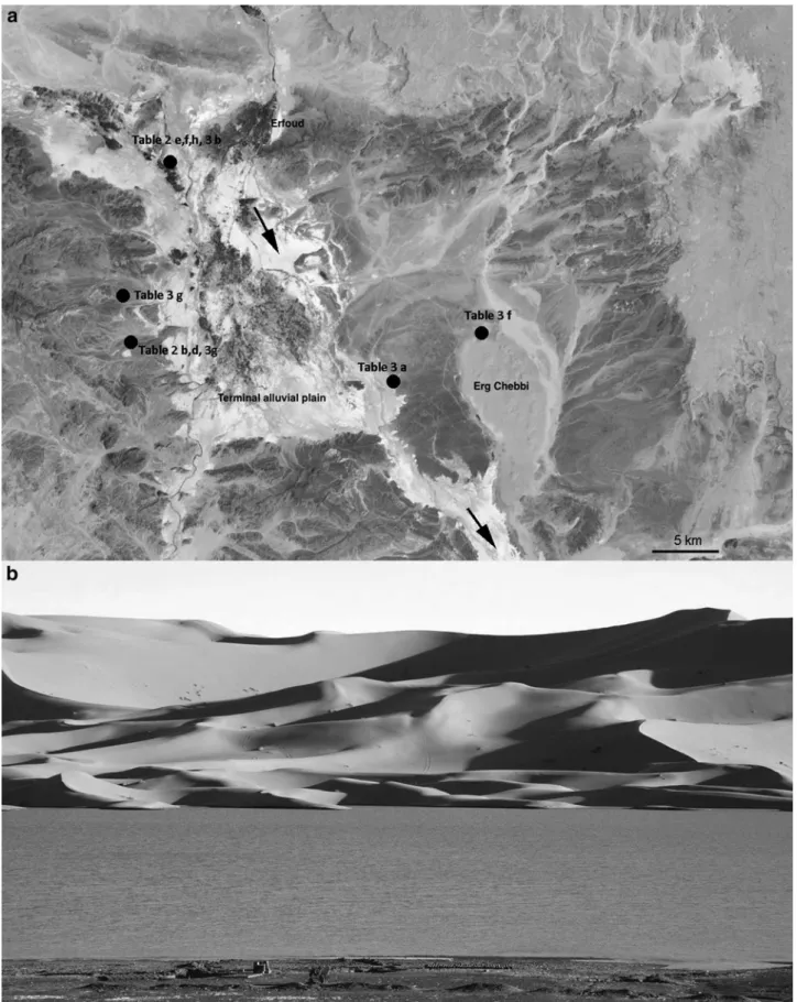
highly changeable discharge, gradually diminishing water at the lower reach, evaporite and clay-rich deposits, and ephemeral standing water bodies. The investigated desert areas are dominated by ephemeral streams that flow south- ward from the Atlas Mountains, which are active only during rainy periods in the mountains. The most important of these rivers is Oued Ziz, its source located in the High Atlas Mountains, which flows though the Tafilalt region where a great deal of field work has been carried out. In the Tafilalt plain, the Oued forms alluvial plains rich in clay and evaporite deposits. In this area, the river loses much of its water such that it ceases to exist at the border of Sahara. In the mountain reach, the discharge is close to 1000 m3/s in winter and does not exceed 10 m3/s in summer.
In the investigated area, the Oued Ziz is strongly ephem- eral, and it forms a set of terminal sabkhas (salty flats formed by evaporation in arid regions) (Hugget, 2007) made up of extensive clay, fine-grained sand, and evaporitic strata at the alluvial plains that accumulate during flooding. A portion of this water evaporates, but some of it typically recharges the shallow water aquifer. The water table is at a depth that ranges from 10 to 30 m. The area of these terminal plains is about 20 km wide and 60 km long. However, the Oued Ziz represents a major river system in the Quaternary evolution of Sahara. During humid climatic periods, when Sahara was predominantly a savanna rich in lakes and rivers, Oued Ziz flowed from the High Atlas up to the Erg Inguid in Algeria, a distance of about 600 km. Therefore, this major river is now composed of several independent reaches that are ac- tive locally depending on local and rare episodes of pre- cipitation.
In winter, the water table can rise up to the surface in a few locations in the area of Erfoud (Figure 8). This area cor- responds to two different systems: the sebkhas (ephemeral standing bodies of water on the order of 1 km wide, linked to the alluvial plain) and the border of the Erg Chebbi. This latter lake is the product of an aquifer that lies between the base of the sand of the Erg Chebbi and the substratum that consists of Paleozoic rocks. This aquifer is likely charged by rain that falls over the erg and penetrates to highly porous eolian sand of the erg. The lake lasts 2–3 winter months and disappears in the spring due to the decrease of rainfall as is the case for the sebkhas-type lakes. However, apparently the deposits are not composed of evaporites but of fine-grained clastic sediments.
The site No. 2038 (mentioned above as ephemeral lake in 4.1 section) comprises such clay-like deposits and plain-shaped sediment accumulations without inflow-related channels.
4.4. Applying the analogue results for Mars
Several recent observations suggest the range of spatial scales (from orbital image scale to cm–mm scale in certain outcrops) that should be used in forthcoming missions, in- cluding the planned Mars sample return, where highly tar- geted sampling is planned, partly from the subsurface.
Researchers were able to effectively connect orbital data andin situobservations by the highly mobile Curiosity ro- ver, in this casein situresults helping to extrapolate beyond the rover’s traverse (Milliken, 2015). At the foundation of Mount Sharp in Gale crater, the border between thin and cross-bedding layers was observed by the Curiosity rover at a site within Gale crater, the location of which could not be Table5.ComparisonofObservationsofVariousSpatial-ScaleSurfaceFeaturesAnalyzedbyDifferentMarsMissions, TheirImportance,andExamplesatIbnBattutaAnalogueSites,FocusingonSedimentaryIssues Spatial scaleExamplemissionsObservablefeaturetypesBackgroundinformation onprocessescouldbegainedSpecificIbnBattuta analogueaspects kmVikingorbitersFluvialfeatures,depositional/ erosionalareasIdentificationofsurfaceformingagents (waterflow,windtransport)Wadisatundulatingandsmooth terrainswithmanybranches 10mMGSorbiterFluvialbranches,smoothsedimentary infill,dunemorphology,substantial verticalchangesinstrata
Temporalchangesofsedimentaryagents, someenvironmentalfactors duringdeposition
Analysisoffluvialstrata,lithified sedimentarysequences, includingstromatolites mMROorbiterIndividualblocks,gravelbars, smoothsurfacedepositsLocalchangesinthesurface modifyingagentsRockcoverageformationmethods cmMERs,CuriositylandersImbrication,dryingproducedcrackVerticalsequencesofcycles insedimentationLakedeposits’strata, paleoenvironmentalrecord mmMERs,Curiositylanders (withfewsubsurface information)
Particlesizeanditsdistribution, veinfills,concretions,metasomatic features,finelamination Depositionalconditions,alteration processesduring/afterdepositionRecentandoldsedimentarystrata ofvariousorigins,including biogenicsignatures mmEXMroverinrestricted form,moresubsurface information
Particles’shape,surfacepattern, resorptionsignatures,mineralshapes, mineralgrowthsuperposition Complexpaleoenvironmental reconstruction MERs,MarsExplorationRovers.
determined from orbital data alone, but required in situim- aging from a meter-scale distance (Grotzinger et al.,2015).
Curiosity also analyzed the Shaler outcrop (fluvial sand body) of only 0.7 m thickness with seven separate facies based on grains and bedding along the feature (Edgaret al., 2014). The Opportunity rover also demonstrated the importance of centimeter-scale analysis of outcrops in attempts to reconstruct past conditions by using scale cross-lamination observed from a decameter distance in Erebus crater, Olympia outcrop (Grotzingeret al., 2006).
However, there are few case study examples on the ideal number and spatial setting necessary to establish in situ observations supported by ‘‘high-resolution’’ geological context to facilitate centimeter-scale sample targeting. With the many lessons learned from analogue field tests kept in mind, future methodological needs for effective sample collection on Mars will need to be determined. A sequence of steps toward realization of these goals (observations at different levels) are summarized in Table 6.
The results gained by the analysis of the two main re- search questions noted here could support the targeting of forthcoming missions by the following topics (especially the knowledge gaps listed in the rightmost column in Table 6).
The acquisition of several orbital images of a same target area under different geometries should be tested, which would be quite difficult and expensive.
Early tests with drones would help to clarify the range of ideal and required observation types. It would also be useful to initiate a discussion with mission experts to discern how this suggestion would fit with the possibilities and cap- abilities of a regular orbiter mapping mission.
For the determination of the ideal numbers and spatial arrangement of outcrops required to be imaged nearby on the surface for firm geological context, establishment should be tested at analogue key sites.
The last level of targeting: the selection of a given layer or number of layers to be sampled should also be tested at analogue locations with sample acquisition from more lo- cations than foreseen to select the most relevant ones con- sistent with the above acquired context. The possibility of more sampling and subsequent later analysis, including better laboratory facilities on Earth than are available on- board a rover, makes analogues ideal to develop and im- prove the method that should be followed during the Mars sample return.
5. Conclusion
In this work, we have presented an overview with ex- amples and lessons learned during analogue studies con- ducted at Ibn Battuta field sites with the intent to discern how geological information from different spatial scales can be used to identify the best locations for targeted sampling. The remote images and local walking field survey-based analysis were completed by shallow sub- surface exploration.
Comparing satellite-based and in situ recorded images, we were able to examine new ways by which to extrapolate key information from satellite images below the limit of spatial resolution. The identification of various rocky desert types (which differ in albedo and color when imaged from above) can be made in satellite images, but no guidelines are Table6.ProposedSpatialScales(Rows)andRelatedInformationTypeandtheRelatedKnowledgeGapsWhereEarth AnaloguesCouldProvideNewandMissingInformation SpatialscaleRequiredmethodsGainedinformationKnowledgegapTestableanalogueaspect mResolution, 10kmcovered area,remoteimages
Orbital(ordrone)imaging, topography,DTMsTargets’arealcharacteristics, traverseplanning, candidateareas ofinterest Methodtoconnectorbitalappearance tonearbysurfaceappearance andexpectedfeaturesbelow spatialresolution
Remote—insituappearance correlationofdeserttypes, lakebeds,channels mResolution, 10–100m coveredarea, on-sitenearby
Surface-basedside-looking imaging,DTMsfrom stereoimages, topographyrecording Candidate-layersequences, sedimentarycontext, selectionofpossible outcropofinterest GeneralrulesontheoccurrenceonMars (partlyonEarthtooatdesertareas), methodtoselectidealnumber/spatial distributionofusedoutcrops toreconstructcontextandfitthem torovers’traverse Generatingcontextfromseveral outcrops,testingthesite-type-related optimaldataacquisitionmethod (numberoftargets,characteristics ofimagerecording) cm–mmResolution, dm–mcoveredareaNearbyhigh-resolution imaging(including microscopes)
Grain-scaledata,fine layering,desiccation, andveinfillings Methodonhowtoconnectthefine-scale gaineddatatothegeneralcontext toidentifybesttargetstosample Testtheideallayer’sselection accordingtostratatypes,testideal methodtosampleonlythetargeted layerwithoutnearbysediments
18 KERESZTURI ET AL.
available to date as to how to use this variability to ex- trapolate differences in surface desert morphology and for- mation. Targeting for in situwork with the use of remote sensing data can be most effective if several images of the same target can be recorded under different illumination and geometric conditions (e.g., different local solar time), which would make remote images more informative. Analogue site study results suggest that it is not necessarily a requirement that ephemeral lake beds exhibit indicative surface features in every case, and occasionally only shallow subsurface exploration can indicate origin. Based on the analysis of wadis, a large number of horizontally elongated surface outcrops were exhumed by fluvial cut into earlier deposited sediments. Such outcrops can greatly support the location of the ideal target for sampling, but to date this has been minimally explored or applied to the study of Mars.
In this study, we found that stratigraphic features (lami- nation, layer turbulence, deformation features, etc.) could be better identified in open air outcrops, and that such features are less observable in borehole-wall scans and even less in the acquired samples. Thus, without establishing context from several nearby outcrops and remote-based regional data, our ability to understand geological history on Mars, even with sophisticated sample analysis, is much more difficult. Meter-scale vertical outcrops, which are abundant at the analogue wadis we studied, provided such context in detail that might be around, or just below, the limit of res- olution of martian data.
The mineral-type identification is made difficult by clay- sized small grains that often attach to the surface of larger grains, while even weak fragmentation (during transport, e.g.) could separate most of these attached grains. This difference with regard to the presence of attached small grains is true not only for optical but for IR and Raman methods as well, as loss of the attached grains supports the acquisition of clear phases spectra, for example, for Exo- Mars rover’s analysis.
Shallow subsurface exploration can provide useful infor- mation on the geological history of a given terrain even when materials can only be investigated to relatively shallow depths.
In our work, which involved roughly 20-cm-deep subsurface excavations, four of six locations investigated provided a distinctly different assessment of structure and lithology than was indicated by surface interrogation, and this helped to fa- cilitate reconstruction of geological events that had occurred at these analogue sites. This is demonstrated by the three ex- amples below.
(1) At site No. 0403, the homogeneous small size (1–
2 cm) debris cover of ‘‘typical desert appearance’’
was transported by a large areal flood after an earlier lacustrine wet period when clay deposition occurred, despite the fact that the area looked like many other stony desert scenes at first sight.
(2) Site No. 0203 seemed at first to be a typical reg desert-type location, based solely on its surface ap- pearance, that formed byin situ weathering. Shallow subsurface exploration, however, revealed no sup- porting bedrock, a finding that required consideration of another origin for the surface material.
(3) Site No. 2038 was once an ephemeral lake and ex- hibited few surface signatures of the lacustrine phase
(mainly covered by thin sand sheet from the nearby dunes). Subsurface layering, however, revealed the occurrence of at least two cycles of sand/clay depo- sition in a wet environment.
These observations infer that shallow subsurface exca- vation can clarify important water-related questions on Mars, where earlier lake beds could be easily buried in the recent wind-dominated era.
In the present study, analogue investigation provided examples and lessons learned as to how ideal study sites can be targeted, where on-site analysis is important with regard to selection of targeted areas on 10–100 m distant scales.
Ideal sites to sample, such as the latest fluvial episodes and locations where wet signatures are closest to the surface, could be better identified on-site by way of remote images alone. In our study, natural outcrops 0.5–1.0 m in height were consistently present at the eight fluvial channels ana- lyzed and thus would have been difficult to identify on Mars from the available data alone. Such features, however, may be abundant on Mars and lying in wait for discovery.
Geological information on different spatial scales should be assessed in particular at the meter range with a series of observations. In an ideal workflow, orbital data, local out- crop scanning, borehole-wall analysis, and detailed sample inspection are also to be considered; however, more ana- logue work will be required for the development of such case studies that can positively influence mission scenarios with regard to the ideal sequence number and spatial ar- rangement of nearby natural open-air outcrops.
Astrobiology-relevant aspects of our study are important drivers for present and upcoming Mars missions such that context information will help to facilitate instrumental planning, sample preparation, and analysis optimization.
With regard to future mission goals (ExoMars’ subsurface drilling procedures and sample return), present and future Ibn Battuta on-site investigations will help to improve our capability in ideal site targeting and localization below the meter spatial scale.
Acknowledgments
The field work and site access were supported by the Trans National Access project of the Europlanet RI (H2020 fund), while the related laboratory work was supported by the COOP-NN-116927 by NKFIH and the GINOP-2.3.2-15- 2016-00003 funds, the Mars-related aspects gained informa- tion through COST TD1308. Europlanet 2020 RI has received funding from the European Union’s Horizon 2020 research and innovation programme under grant agreement number 654208.
Author Disclosure Statement
No competing financial interest exists in connection with this article from any of the authors.
References
Amador, E.S., Cable, M.L., Chaudry, N., Cullen, T., Gentry, D., Jacobsen, M.B., Murukesan, G., Schwieterman, E.W., Ste- vens, A.H., Stockton, A., Yin, C., Cullen, D.C., and Geppert, W. (2015) Synchronous in-field application of life-detection techniques in planetary analog missions. Planet Space Sci 106:1–10.