Corresponding author: kereszturi.akos@csfk.mta.hu
Chapter
T HE P ALEO -E NVIRONMENT
R ECONSTRUCTION ON M ARS : F OCUS P OINTS FOR THE N EXT
A STROBIOLOGY M ISSIONS
Kereszturi, A.
1, Kanuchova, Z.
2, Dartnell, L.
3and Hauber, E.
41Research Centre for Astronomy and Earth Sciences, Konkoly Thege Miklos Astronomical Institute, Budapest, Hungary
2Astronomical Institute of the Slovak Academy of Sciences, Tatranska Lomnica, The Slovak Republic
3Department of Life Sciences, University of Westminster, London
4Deutsches Zentrum für Luft- und Raumfahrt (DLR), Berlin, Germany
A
BSTRACTThe reconstruction of past environmental conditions is important for estimation of the astrobiology potential and to support the targeting of future missions for Mars. Reviewing those observable features (e.g., paleo- environment indicators) that help such reconstruction is important, as they provide focus for current and future research, both in remote and in situ activities, as are Earth based laboratory analysis and simulation. In this
work, these indicators are collected and characterized, focusing on the available data, uncertainties, missing information and targets of future research work. These indicators can be classified into groups of: surface morphological (kilometre spatial scale, water and ice related surface structures like fluvial channels, alluvial fans, banks, etc.); in situ m-µm spatial scale features (observable especially in vertical outcrops); and mineralogical (mineral types, OH content).
Based on the collected indicators, good general (although not complete) knowledge is available on surface morphological features. Whereas information can be extrapolated from these data regarding the liquid water or frozen ice volume, and temperature, during the formation of certain features, information on pH and salt content, as well as temporal issues, can be only poorly estimated. Mineral paragenesis and different types of indicators should be used together to further support the interpretation. The missing data regarding certain environmental conditions represent the directions for future research.
Keywords: astrobiology, Mars, geomorphology, sedimentology, mineralog
I
NTRODUCTIONImportant new knowledge has recently emerged that allows the estimation of past conditions on Mars, including the possibility of ancient liquid water in the form of channels (Hynek et al. 2010), sedimentary deltas (Pondrelli et al. 2008), standing water bodies (Didibase et al. 2013), and weathering processes based on ancient phyllosilicates (Poulet et al. 2005).
These are all important for improved understanding of the astrobiological aspects there, in particular habitability. However, the reconstruction of ancient conditions is difficult, partly because there is restricted information from selected signatures of the past, and the findings from different types of observations could be weakly connected to each other.
Despite these problematic aspects, there have been concerted efforts to reconstruct the past conditions on Mars. The aim of this work is to collect and briefly summarize the current knowledge on such observable features and structures (including by remote sensing, in situ Mars surface observations, and analyses of Martian meteorites in laboratories on Earth)
that could help to reconstruct the ancient conditions both on the surface and in the interior of the red planet. See Figure 1 for sme examples.
The rationality of this work is threefold: 1. provide a wider overview than earlier publications that focused on separate indicators; 2. define the missing and weak points; 3. provide one more approach for interdisciplinary work to better exploit the analysis of astrobiology potential. Based on these collected results, it will be possible to compare different levels of indicators and identify possibilities for their combined usage. It will be also possible to identify knowledge gaps where perspective opportunities exist, and thus highlight topics that future missions could explore further.
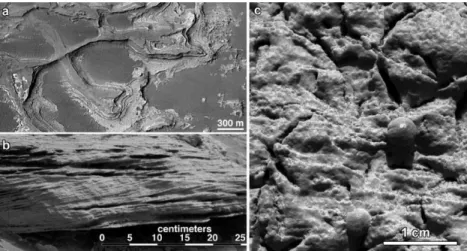
Figure 1. Example features for paleo-environment reconstruction on Mars: a) Inverted fluvial delta-like sedimentary structure in Eberswalde crater with outcroped layers poiting to an ancient river that entered into standing water body (Mars Global Surveyor image). b) On the image of Curiosity rover’s MastCam cross-bedding seen in “Whale Rock” target as evidence fluvial activit and waves or ripples of loose sediment the water flown over. c) Microscopic image of the Opportunity rover of a rock outcrop at Meridiani Planum, called Guadalupe with about 1 cm long vugs that left behind of dissolved minerals while the small spherea are hematitve concretion fored by the support of liquid water. (NASA, JPL-Caltech, MSSS, US Geological Survey).
In this work, the term “indicator” is used for an observable feature that holds information on past conditions on Mars, regardless of the spatial scale
and target type (for example, geological formation from an extended lakebed sediment or a single mineral). These indicators might provide information on only some specific aspects (such as temperature, pH, accessible water, etc.), and their interpretation is model dependent. However, they remain useful, and if several indicator types point to similar conditions they support a stronger argument for the proposed ancient conditions. Such knowledge supports the better planning of, and data analysis from, future missions to Mars (Barnes et al. 2017).
M
ETHODSThis review uses the results obtained by many different studies, and where possible several publications are cited for the same indicator. We have only listed indicators that have been well established by several independent publications and so represent a consensus within the community. Inferred conditions might be ephemeral or representative over only a small volume or area, and so need not necessarily characterize a substantial area or protracted period of time of Martian history. They do, however, provide the best available method to estimate past conditions.
The uncertainty from such reconstruction methods could be reduced if several indicators point to similar conditions in a certain location or the same indicator points to similar conditions at different locations on the planet.
Examples of the former would be several minerals formed paragenesis, or several identified interconnected surface structures, such as erosional voids, channels and sedimentary features all supporting the existence and transport of liquid water. The best approach for estimating past conditions based on any particular indicator is informed by laboratory data, model computations and Earth analogue based observations.
The core of this work is presented in the form of tables according to groups of various indicators, including the specific name, inferred paleo-
environmental conditions of the given indicator, together with references where further details and examples on the usage of the given indicator are presented.
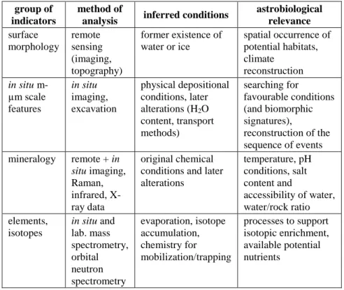
Although several classification schemes are possible, the organization of the indicators list used here was chosen for its combination of both utility and simplicity. Necessarily, there are small overlaps between these classes, but the separation is strongly related to the different methods that should be used to analyse these aspects in the different classes. Table 1 summarizes the main groups of the indicators, separated into surface morphological, in situ m-µm scale, mineralogical, elemental and isotopic classes.
Table 1. Group of specific indicators discussed in this work
group of indicators
method of
analysis inferred conditions astrobiological relevance surface
morphology
remote sensing (imaging, topography)
former existence of water or ice
spatial occurrence of potential habitats, climate
reconstruction in situ m-
µm scale features
in situ imaging, excavation
physical depositional conditions, later alterations (H2O content, transport methods)
searching for
favourable conditions (and biomorphic signatures),
reconstruction of the sequence of events mineralogy remote + in
situ imaging, Raman, infrared, X- ray data
original chemical conditions and later alterations
temperature, pH conditions, salt content and
accessibility of water, water/rock ratio elements,
isotopes
in situ and lab. mass spectrometry, orbital neutron spectrometry
evaporation, isotope accumulation, chemistry for mobilization/trapping
processes to support isotopic enrichment, available potential nutrients
It is worth mentioning that biomarkers (Gargaud et al. 2011) are not categorized here as a separate group, as the aim of this work was to overview
abiotic environmental indicators. However, in certain cases there might be some overlap between them, for example in the case of minerals (such as biogenically-mediated mineral formations), and especially isotopic ratios (such as biogenically enhanced concentrations of lighter oxygen or carbon isotopes).
R
ESULTSIn this section, the four main groups of indicators are listed in tables accompanied with explanations. Due to the relatively large number of issues, only concise information is presented for each indicator, as the aim was to overview and compare them, and evaluate in what cases and for which geological contexts they could be used.
Surface Morphological Indicators
Table 2 lists the surface morphology indicators. The features classified in this group are mostly observable from Mars orbit by remote sensing, although they could also be seen from nearby on the surface. For proper interpretation, however, the whole structure should be evaluated, and thus orbital imaging provides the preferred source of information. These structures are mainly analysed in optical wavelengths, and rarely in infrared or hyperspectral images, as well as by laser-based (or other methods) topographic data.
Table 2. Surface morphology indicators with their name (left) and the conditions they point to (right), with occasional examples. The inferred
conditions in the second column are all related to climate, thus climate is not listed as a characteristic here. For the formation models the
most probable ones are presented however in several cases there are substantially different model approaches,
for example in the case of gullies
indicator inferred conditions
fluvial channel surface flow of liquid water, water source and ice melting (Barnhart et al. 2009), discharge (Irwin et al. 2005), climatic context for surface runoff (Howard et al. 2005)
alluvial fan surface flow of liquid water (Moore and Howard 2005) Gilbert-type
delta-like structure
standing water bodies (Dibiase et al. 2013), liquid volume and deposited mass, active duration of rivers (Kleinhans et al. 2010) lake basins standing water bodies, liquid volume (de Hon 1992)
chaos terrains suggestive of subsurface ice melting (Chapman and Tanaka 2002), or release of bound water from minerals (Max and Clifford 2008)
faults as outflow channel sources
deep liquid aquifer breakup (Burr et al. 2002) cryocarstic
depressions
former existence of ice and unconsolidated particles (Carr and Schaber 1997)
moraines glacial ice mass movement, areal distribution of ice accumulation and ablation (Squyres 1978, Head et al. 2010)
eskers existence of meltwater under former ice sheets (Kress and Head 2015)
drumlines existence and movement of former ice sheets (Kargel and Strom 1992)
gullies insolation driven melting of formerly deposited ice (Costard et al.
2002) polar cap basal
melting features
elevated geothermal gradient and/or volcanic heat, melted ice volume (Clifford 1987)
water ice exhumed in young caters
existence of recently deposited ice below the surface at middle- high latitude terrains
fluidized ejecta of flow lobe craters
subsurface ice that melted during impact (Mougnis 1981)
polygonal structures (m scale)
desiccation/ice condensation cycles (Mangold 2005), melting/freezing cycles (Seibert and Kargel 2001)
The surface structures listed in Table 2 provide information on the ancient conditions based on the following arguments (focussing mainly on their possible usage and uncertainties):
Fluvial channels are suggestive of surface runoff of liquid water, and their spatial occurrence occasionally points to the type of water source, e.g., surface precipitation (the sources of the channels close to, and arranged according to, regional watershed) or ice melting (elevated local drainage density surrounding potential local ice sheets). However other channels with steep slopes and a theatre-shaped starting area without a potential surface source might point to subsurface sapping. The outflow channels point to high volume and a localized water source (provided by collapsed chaos terrains or supported by sudden, high volume lake outflows). Uncertainties are also present. For example, a difficult question is to what extent these fluvial channels point to conditions favourable for the extended maintenance of liquid water, as there may be rare events that produced only ephemeral runoff (like in the case of many deserts on Earth where fluvial channels are located in otherwise dry terrains). It is also poorly known for how long the channels were active. If one assumes their water might contain freezing point depressing chemicals the climatic constraints they provide are also weak (however, during the early Noachian period, the amount of such chemicals shouldn’t be high, as a relatively long time is necessary for their accumulation.).
Alluvial fans might point to ancient fluvial sediment transport and locations where the sediment was deposited. Uncertainties exist, however, in their identification and the estimation of volumes (and thus discharge) of fan producing fluvial systems. Gilbert-type deltas point to fluvial sediment accumulation and the former existence of standing water bodies, and provide a constraint on the volume of these lakes. Here, uncertainties come from their firm identification as they are not always similar to Earth based counterparts, and morphological variety is present among them. The estimation of the duration of active (wet) periods is also uncertain.
Chaotic terrains point to subsurface locations where ice was melted or H2O-containing minerals/clathrates released their liquid content, although uncertainties exist regarding the exact source of the released water. Faults
that are the sources of outflow channels point to deep water aquifers that poured liquid to the surface. Uncertainties exist, however, regarding the depth of source and the origin of such deep liquid water.
Among the ice related surface features, moraines have been identified mainly at the north-western side of the large equatorial volcanoes at Tharsis, and they were probably left behind by former glaciers, which existed only during periods of increased orbital tilt. These structures point to the existence of thick glacial ice, confirming the strong climatic change.
Although there are several candidate glacial moraine terrains on Mars, it is not easy to confirm their origin in several cases, making the use of these indicators globally uncertain. Eskers point to the former existence of ice sheets and melting at their bottom in the form of subglacial meltwater deposited sediments. The main uncertainty here is the identification of such features. Polar basal melting features occur mainly in the southern circumpolar region and point to former melting and liquid water flow/seep below the polar ice cap, where local volcanic heat probably produced the melting.
Subsurface ice is inferred from craters with fluidized flow-like ejecta lobes pointing to the liquefaction of ejecta during emplacement. Although fluidization may occur without liquid by specific physical process with careful consideration those craters can be identified, which might hold the signature of melted ice during the ejecta emplacement, pointing to the existence of subsurface ice. Uncertainty exists in the volume or mass ratio of this subsurface ice. Polygonal structures of 1-10 m size are related to several possible processes but are mainly connected to periodic desiccation/hydration and melting/freezing cycles producing volume changes in the shallow subsurface. The changes in the H2O content might be caused by climatic changes, and different sized polygons could be produced by different temporal scales of changes – but probably longer than one year timescale. Uncertainty exists in the formation of these polygons and their relation to the existence/lack of H2O in the shallow subsurface.
Table 3. Summary of cm-µm scale morphological indicators. The rightmost column provides the Martian conditions that can be estimated using the given indicator. In cases where there are different
models or several different conditions could produce the same indicator, these are listed, separated by a semicolon. The aim during
the compilation of these aspects was to list mainly observed and not only theoretically suggested indicator
indicator example(s) if
observed indicated conditions/circumstances aggregations,
concretions
hematite spherules at Sinus Meridiani, H2O supported aggregation at the Phoenix landing site
supported by iron-oxide, -hydroxide and sulphate cementation; other type is possible by ephemeral humidity with adsorption and cementation; mineral formation according to orbital element changes pointing to moderately elevated temperature and humidity conditions bedding planar and irregular
lamination, cross and convolute bedding (Grotzinger et al.
2005)
characteristics of the depositional environment;
separation of wind/water/ice transport modes;
low angle lamination and large-scale cross- bedding might suggest transport across a dry surface (Grotzinger et al. 2004)
duri-crust and cemen- tation
iron-oxide, - hydroxide and sulphates cemented regolith (Kömle et al. 2017)
cementation by sulphates and oxides from trapped atmospheric humidity on the (former) surface; might also form via mobilization of salt ions by adsorbed water layer (Jakosky, Christensen 1986)
fractures and veins
sulphate filled veins (Newsom et al.
2005) in Shoemaker, Grasberg, and Burns formations (Arvidson et al.
2015)
hydrothermal fluid migration; support for the determination of the order of events if superpositional relationships are visible;
intergrowth of certain minerals points to eutectic freezing (Rieck et al. 2005); might point to mechanical transport, fluid circulation and desiccation
granular properties
roundness of gravels at
Curiosity’s landing site (Szabó et al.
2015)
transport mode, relative duration and suffered abrasion estimation; wind strength and atmospheric density (Yingstet al. 2013)
ice/sand wedges
has not been observed but might accompany a range of periglacial features
bulk ice condensation/desiccation; aeolian sand accumulation (Levy et al. 2009)
indicator example(s) if
observed indicated conditions/circumstances layer defor-
mations
fallen pyroclastic bomb intrusion at Home Pate (Squyres et al.
2007)
plastic state of deposited material; ice related cryoturbation, water escape features and water content estimation
cracks in sediments
shrinkage cracks in Erebus crater Olympia outcrop (Grotzingeret al.
2006)
desiccation mainly by H2O content change;
points to earlier H2O source and later dry conditions
planation surface in vertical strata
cyclic layer packages at Sinus Meridiani
unconformities in vertical strata might represent subaerial erosion after burial (Wezel, Baioni et al. 2014); intrusion of fluidized clastic material into fractures; production of nodular sulphate dykes and pipe-like fluid conduits; pulses to diapiric rise and exhumation
voids left behind by dissolved minerals
psuedomorphic vugs in sulphate rocks in Meridiani Planum (Grotzinger 2004b),
very rough estimation on the previously extant mineral, the plate-shaped voids in Meridiani Planum left behind probably by
MgSO4*11H2O (Peterson and Wang 2006);
hydration and freezing (Marion et al. 2008) ventifacts,
pitted rocks (not primarily vesicular)
various features.
like faceted edges, elongated pits, flutes, grooves, etc.
at the Pathfinder landing site (Bridges et a. 1999)
produced by wind abrasion scours and ventifacts; ice deposition on rocks under different climate might also exist; might point to different past wind directions (Laity and Bridges 2009)
There are several proposed models for the formation of gullies, of which the most probable and popular today is the melting of formerly deposited ice masses. Their occurrence shows specific latitudinal, altitudinal and exposure orientation characteristics, according to the favourable locations of ice accumulation and melting under recent past climates that differ from the current. Recently deposited and dust covered latitudinal ice bands exist in both hemispheres, where recent impact events have excavated the almost pure ice from below the decimetre thin loose debris cover that had been deposited under a climate that differed from the current.
In Situ Observed cm-µm Scale Indicators
An important group of information can be gained using on-site observations by landers on the Martian surface targeting features that are smaller than those that can be observed by orbital methods, but larger than the scale of minerals. Features listed in Table 3 range from centimetre to micrometre scale, and could be observed by various optical cameras of the probes, including panoramic cameras and microscopic imagers. Many of these indicators are related to sedimentary aspects, as almost every sedimentary feature provides information on its formation conditions. (A specific case is the MaMISS instrument on ExoMars rover, which will be able to scan the drilled borehole-wall in the infrared range, providing information mainly on mineral composition. However, in an ideal case it can also provide spatial data on the separation of grains or sedimentary deformation features)
Examples from the range of various features that could be used in paleo- environment reconstruction are described below. Aggregates on the Martian surface might be produced partly by electrostatic forces (Merrison et al.
2004), but also by chemical cementing of some materials (e.g., salts or iron- oxides). Hematite grains could, for example, aggregate in aqueous solution (Sexon et al. 2014). A thin liquid layer might also support aggregation in general. This latter aspect was found on Mars, but is poorly analysed. The effect of regolith particle aggregation was observed by Phoenix lander in its scoop, and also when some regolith was deposited on the sieve like cover of the sample analyzer’s opening. In this case, the material dropped on the cover was aggregated by H2O related cementation, and did not go through the sieve. A specific observation of cementation came from the LIBS and ChemCam onboard Curiosity rover at conglomerates of Goulburn, Scour, Link and Hottah outcrops, where the feldspathic grains were cemented by water bearing phases (Mangold et al. 2013).
Different lamination and cross-bedding types were observed by Opportunity rover in Meridiani Planum (Grotzinger et al. 2004) including cross-bed sets with a thickness of 5-7 cm, and small-scale festoon cross- laminae. The bedding at Eagle crater suggests both aeolian and subaqueous
environments, in the wet domain by sediment transport in subaqueous, low- velocity flows. At the Shaler outcrop in Gale crater, grain size and cross- stratification point to unidirectional currents in a fluvial sedimentary environment (Sanjeev 2014). At the “Darwin outcrop”, the clast-supported nature, the coarse grains, and the occurrence of rounding of clasts also indicate transport by aqueous flows, while the lack of well-sorted fabric and the size grading of clasts point to rapid deposition rather than sustained fluvial activity.
There is a need to develop or adjust Earth based classification of conglomerate rock on Mars as it turned out during the traverse of Opportunity rover (Mangold et al. 2027) for elevated Fe content sediments with igneous clasts together. A good example of the diversity of grain sizes, shapes and colours was identified by the MAHLI camera at Jake Matijevic rock (Aileen et al. 2013), pointing to a diverse origin.
Superpositional relationships support the reconstruction of sequence of events. For example, the Opportunity rover at Columba Hills observed fine- grained evaporite muds that have been ripped up, transported and redeposited again, pointing to subsequent transport after first deposition.
Even later formation of vugs happened that cut across bedding, thus the minerals once filled the vugs formed diagenetically inside the sediments and was later dissolved (Herkenhoff et al. 2006).
Mineral Iindicators
Spectroscopic observations (mainly in the infrared range) of the Martian surface provided by Mars orbiters can be used for the rough estimation of the mineral composition of the target. Measurements by spectroscopic detectors and laboratory equipment on-board in situ missions usually give more precise direct or indirect information on the Mars surface composition.
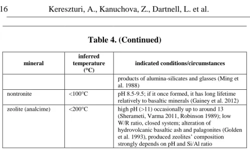
Table 4 lists the most important and already-identified mineral indicators.
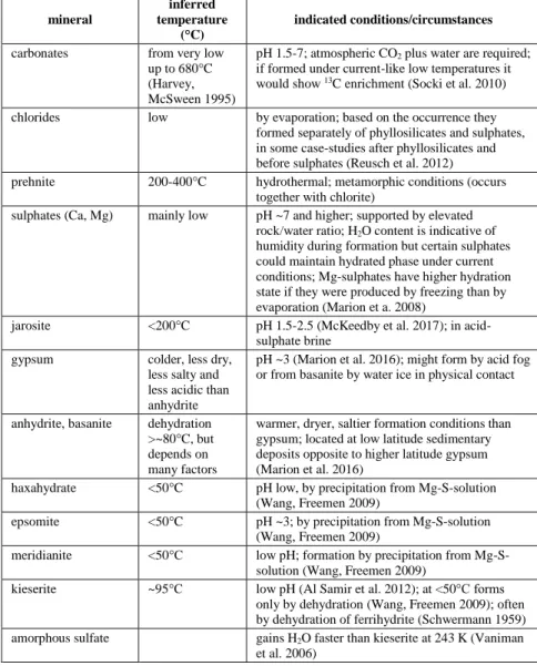
Table 4. Mineral types and inferred formation conditions. The listed values (temperature, pH, etc.) are rough estimations of averages and they might depend on various parameters. In extreme cases, they could be beyond the indicated values. Further information can be found in the cited references. (Please note that while chlorites and prehnite are two different types of minerals, they are indicated
together here as they typically co-occur)
mineral
inferred temperature
(°C)
indicated conditions/circumstances
carbonates from very low up to 680°C (Harvey, McSween 1995)
pH 1.5-7; atmospheric CO2 plus water are required;
if formed under current-like low temperatures it would show 13C enrichment (Socki et al. 2010) chlorides low by evaporation; based on the occurrence they
formed separately of phyllosilicates and sulphates, in some case-studies after phyllosilicates and before sulphates (Reusch et al. 2012) prehnite 200-400°C hydrothermal; metamorphic conditions (occurs
together with chlorite)
sulphates (Ca, Mg) mainly low pH ~7 and higher; supported by elevated rock/water ratio; H2O content is indicative of humidity during formation but certain sulphates could maintain hydrated phase under current conditions; Mg-sulphates have higher hydration state if they were produced by freezing than by evaporation (Marion et a. 2008)
jarosite <200°C pH 1.5-2.5 (McKeedby et al. 2017); in acid- sulphate brine
gypsum colder, less dry,
less salty and less acidic than anhydrite
pH ~3 (Marion et al. 2016); might form by acid fog or from basanite by water ice in physical contact
anhydrite, basanite dehydration
>~80°C, but depends on many factors
warmer, dryer, saltier formation conditions than gypsum; located at low latitude sedimentary deposits opposite to higher latitude gypsum (Marion et al. 2016)
haxahydrate <50°C pH low, by precipitation from Mg-S-solution (Wang, Freemen 2009)
epsomite <50°C pH ~3; by precipitation from Mg-S-solution (Wang, Freemen 2009)
meridianite <50°C low pH; formation by precipitation from Mg-S- solution (Wang, Freemen 2009)
kieserite ~95°C low pH (Al Samir et al. 2012); at <50°C forms only by dehydration (Wang, Freemen 2009); often by dehydration of ferrihydrite (Schwermann 1959) amorphous sulfate gains H2O faster than kieserite at 243 K (Vaniman
et al. 2006)
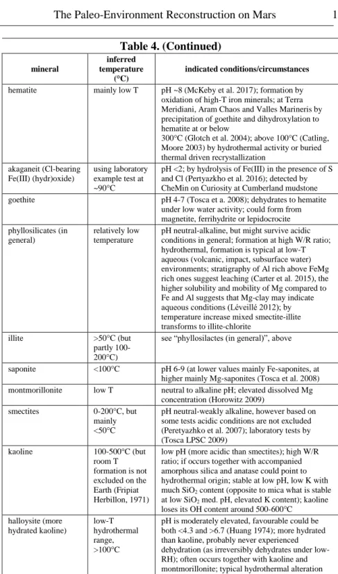
Table 4. (Continued)
mineral
inferred temperature
(°C)
indicated conditions/circumstances
hematite mainly low T pH ~8 (McKeby et al. 2017); formation by oxidation of high-T iron minerals; at Terra Meridiani, Aram Chaos and Valles Marineris by precipitation of goethite and dihydroxylation to hematite at or below
300°C (Glotch et al. 2004); above 100°C (Catling, Moore 2003) by hydrothermal activity or buried thermal driven recrystallization
akaganeit (Cl-bearing Fe(III) (hydr)oxide)
using laboratory example test at
~90°C
pH <2; by hydrolysis of Fe(III) in the presence of S and Cl (Pertyazkho et al. 2016); detected by CheMin on Curiosity at Cumberland mudstone
goethite pH 4-7 (Tosca et a. 2008); dehydrates to hematite
under low water activity; could form from magnetite, ferrihydrite or lepidocrocite phyllosilicates (in
general)
relatively low temperature
pH neutral-alkaline, but might survive acidic conditions in general; formation at high W/R ratio;
hydrothermal, formation is typical at low-T aqueous (volcanic, impact, subsurface water) environments; stratigraphy of Al rich above FeMg rich ones suggest leaching (Carter et al. 2015), the higher solubility and mobility of Mg compared to Fe and Al suggests that Mg-clay may indicate aqueous conditions (Léveillé 2012); by temperature increase mixed smectite-illite transforms to illite-chlorite
illite >50°C (but
partly 100- 200°C)
see “phyllosilactes (in general)”, above
saponite <100°C pH 6-9 (at lower values mainly Fe-saponites, at higher mainly Mg-saponites (Tosca et al. 2008) montmorillonite low T neutral to alkaline pH; elevated dissolved Mg
concentration (Horowitz 2009)
smectites 0-200°C, but
mainly
<50°C
pH neutral-weakly alkaline, however based on some tests acidic conditions are not excluded (Peretyazhko et al. 2007); laboratory tests by (Tosca LPSC 2009)
kaoline 100-500°C (but
room T formation is not excluded on the Earth (Fripiat Herbillon, 1971)
low pH (more acidic than smectites); high W/R ratio; if occurs together with accompanied amorphous silica and anatase could point to hydrothermal origin; stable at low pH, low K with much SiO2 content (opposite to mica what is stable at low SiO2 med. pH, elevated K content); kaoline loses its OH content around 500-600°C
halloysite (more hydrated kaoline)
low-T hydrothermal range,
>100°C
pH is moderately elevated, favourable could be both <4.3 and >6.7 (Huang 1974); more hydrated than kaoline, probably never experienced dehydration (as irreversibly dehydrates under low- RH); often occurs together with kaoline and montmorillonite; typical hydrothermal alteration
Table 4. (Continued)
mineral
inferred temperature
(°C)
indicated conditions/circumstances
products of alumina-silicates and glasses (Ming et al. 1988)
nontronite <100°C pH 8.5-9.5; if it once formed, it has long lifetime relatively to basaltic minerals (Gainey et al. 2012) zeolite (analcime) <200°C high pH (>11) occasionally up to around 13
(Sherameti, Varma 2011, Robinson 1989); low W/R ratio, closed system; alteration of
hydrovolcanic basaltic ash and palagonites (Golden et al. 1993), produced zeolites’ composition strongly depends on pH and Si/Al ratio
Some important examples of the minerals listed in Table 4 are presented below. Hydration based differences between certain minerals could indicate accessible water or ice during their formation or later alteration. However, many minerals could maintain an elevated hydration state if they are buried and isolated from the current dry atmosphere. But kieserite, for example, resists desiccation under current Mars surface conditions, although it is hydrated to epsomite in the presence of water ice (Vaniman et al. 2006).
Gypsum and anhydrite might transform by hydration and dehydration related to climatic changes by differences in humidity and temperature.
Gypsum seems to be stable under current climate conditions, in contrast to anhydrite and basanite that precipitate in solution.
In the early periods of the Martian geological history during the Noachian, surface liquids might help in the neutralization of fluids and precipitation of smectites, zeolites, and carbonates (Zolotov 2009). The formation of clay minerals was characteristic during this period, however they are diverse as their formation depends on several parameters, including pH, chemistry, lithology, and drainage (Güven 1988). Later, the period of ephemeral liquids supported sulfate formation in large masses (producing km thick sediments), including jarosite formation, which could be often accompanied by hematite and goethite precipitation (McCubbin et al. 2009).
During the even later Amazonian period, acidic fog weathering (by low T and low pH thin liquid films) of basalt might be relevant, producing Fe3+, Al, P and S release, with sulphate formation and deposition on the surface.
Evaporation is also an important ephemeral process on Mars that could produce Na-Mg chlorides, Mg, Na sulphates and a lesser amount of gypsum on the surface.
Characteristic process might have been basalt weathering, where in closed systems final pH values were higher in low water/rock ratio and finer particle size experiments (Tosca 2009), influencing the outcome of processes. While in open systems high W/R ratio exists, the residue are Al- clay and Fe-oxides, and transported ions form -SO4, -Cl, -CO3 salts.
Elemental and Isotopic Indicators
Certain processes leave behind their signatures in the elemental or isotopic compositions and ratios. A critical aspect is the separation of the specific target material for the measurement, as the interesting elemental or isotopic concentration might be present only in a small, separated volume of the target (e.g., secondary minerals inside veins). Due to the small portion of the affected area, the relevant signatures might be easily missed in the bulk sample. That’s why these parts should be analysed separately, and not as part of a bulk analysis. The separation of the given part could be difficult and requires much more sophisticated preparation than the analysis of the above listed group of indicators (see Tabe 5).
Hydrogen is not listed among the indicators in Table 5, although it is used by gamma ray spectrometers to identify the probable occurrence of H2O in the shallow subsurface.
Table 5. Elemental and isotopic indicators. Several indicators are also partially mentioned in the group of mineral indicators in Table 4 (e.g.,
sulphur in the sulphates). The observed examples from Mars or Martian meteorites are presented in the second column, while the
third column shows the formation conditions they imply
isotopes,
elements observed examples indicated conditions/circumstances oxygen
isotopes
17O measured in Zagami and Tissint Martian meteorites;
18O in measured in preterrestrial iddingsite of Lafayette (Romanek et al. 1998)
point to distinct isotope reservoirs, but poorly known how to use for temperature estimations in general (Maltsev et al. 2015);
the 18O difference between iddingsite, olivine and pyroxene points to low temperature (>100°C) alteration; point to enrichment in secondary silicates and carbonate based in general; the occurrence deviates from Earth based ratio especially above 350°C (Karlsson et al. 1992), implies two isolated oxygen reservoirs; indicate formation of carbonates by low temperature liquids (Clayton and Mayeda, 1988) carbon
isotopes
observed in the atmosphere of Mars (Webster et al. 2013) and martian meteorites
fluids that exchanged C and O with the atmosphere (Leshin et al. 1996); multiple carbon sources in the surface fines (Leshin et al. 2013)
deuterium present in all Martian meteorites; its ratio differs for different meteorite groups;
measured in phyllosilicates separately too (Mahaffy et al. 2015)
substantially elevated occurrence than on the Earth; in Shergotty meteorite in apatite points to reservoir on the surface and inside the regolith; in GRV 020090 meteorite the H2O in apatite points to enriched
underground water (Hu et al. 2014) on Mars; very early fractionation of near surface reservoirs with atmospheric escape and by 3.9 Ga (Greenwood et al. 2008) potassium,
uranium, thorium
analysed in Martian meteorites, especially in Zagami (Borg et al.
2005), in QUE 94201 (Gaffney et al. 2007);
also by some remote sensing based observations from Mars-5 mission (Surkov et al. 1980)
in primary form point to geochemical processes, in secondary form point to leaching and accumulation by aeolian process and aqueous weathering of fine dust (Zolotov et al. 1993); however, complex behaviour regarding the pH and available water is different for K, U, Th; they support the identification of Martian meteorites’
origin and formation temperature (Nihara et al. 2012)
isotopes,
elements observed examples indicated conditions/circumstances chlorine wide occurrence in
topographic depressions at the southern highlands by ponding of runoff water on the surface (Osterloo et al. 2010);
also identified inside Martian meteorites (Brigdes et al. 2011)
point to the evaporation of surface water bodies; vertical changes in strata might point to temporal variations in pH and water/rock ratio caused by evaporation from the liquid-saturated sediment; downward increasing concentration at Endurance crater points to the release and migration of Cl from previously precipitated minerals (Squyres et al. 2004, 2006)
phosphorus identified and analysed on the Martian surface, including in Wishstone by Spirit (Usiu et al. 2008), in Zagami and some other meteorites (McCoy et al 1999)
elevated concentration in the regolith suggests it was soluble element in Martian acidic fluids; in meteorites points to magmatic fractionation events (McCoy et al. 1999); the occurrence of P, Cl and S is often correlated with each other and show elevated occurrence in the regolith in general, probably by leaching and mobilization (Greenwood and Blake 2006) sulphur abundant in Mars
surface rocks where identified both by remote sensing and in situ analysis, as various sulphates also occur in meteorites (Treiman et al. 2005).
vertical changes in strata might point to temporal variations in pH and water/rock ratio caused by evaporation from the liquid- saturated sediment; also could point to intrusive fluid bodies (Wezel and Baioni 2014) and as precipitation produced alteration features (Gooding et al. 1991) boron boron isotopes were
analysed in Nakhla meteorite (Spivak- Birndorf et al. 2008);
on the Martian surface it was observed in situ by Curiosity inside veins (Gasda et al. 2017)
lack of boron isotope enrichment in Nakhla points to high pH driven dissolution (Spivak-Birndorf et al. 2008); occurrence on the Martian surface points to evaporation related migration of subsurface fluids (Gasda et al. 2017) and also to the possible action of thin liquid films (Yen et al. 2005)
D
ISCUSSIONBased on our general geological knowledge of the Earth, indicators present on Mars allow us to estimate certain geological processes there. One geological “event” might produce a series of indicators that all present
certain signatures of these conditions. For example, an ephemeral water breakout can produce erosional channel and sedimentary units observable form orbit, while in situ detection can identify grain scale imbrication and water escape related sedimentary features. Finally, desiccation might produce evaporites, and increase the concentration of certain elements.
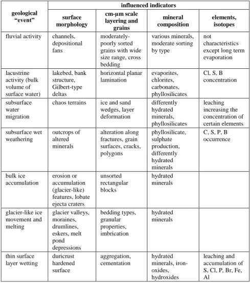
Table 6. Summary of indicator types connected to different geological
“events” important for astrobiology
geological
“event”
influenced indicators surface
morphology
cm-µm scale layering and
grains
mineral composition
elements, isotopes fluvial activity channels,
depositional fans
moderately- poorly sorted grains with wide size range, cross bedding
various minerals, moderate sorting by type
not
characteristics except long term evaporation lacustrine
activity (bulk volume of surface water)
lakebed, bank structure, Gilbert-type deltas
horizontal planar lamination
evaporites, chlorites, carbonates, phyllosilicates
Cl, S, B concentration
subsurface water migration
chaos terrains ice and sand wedges, layer deformation
differently hydrated minerals, phyllosilicates
leaching increasing the concentration of certain elements subsurface wet
weathering
outcrops of altered minerals
alteration along fractures, grain surfaces, cracks, polygons
phyllosilicate, sulphate production, differently hydrated minerals
C, S, P, B occurrence
bulk ice accumulation
erosion or accumulation (glacier-like) features, lobate ejecta craters
unsorted rectangular blocks
hydrated minerals
glacier-like ice movement and melting
glacier valleys, moraines, drumlines, eskers, melt pond depressions
bedding types, granular properties, imbrication
hydrated minerals
thin surface layer wetting
duricrust hardened surface
aggregation, cementation
hydrated minerals, iron- oxides, hydroxides
leaching and accumulation of S, Cl, P, Br, Fe, Al
geological
“event”
influenced indicators surface
morphology
cm-µm scale layering and
grains
mineral composition
elements, isotopes periglacial-like
processes
polygons, cryokastic depressions, desiccation features
sorting, grain orientation, cryoturbation, convolution bedding, ice and sand wedges
occasionally H2O content
impact induced hydrothermal activity
spectral signatures mainly around central peaks
fractures and veins
phyllosilicate, zeolite, serpentine, carbonate, chlorite
solvation and accumulation of various mobile elements volcanic
hydrothermal activity
prepared cemented units
filled veins prehnite, amorphous silica
solvation and accumulation of various mobile elements
The combined use of different indicators (e.g., the evaluation of the size, shape and topography of a sedimentary unit by the remote sensing, study of the units’ layers and grain scale features, and mineralogical and elemental composition by in situ analysis) could strengthen the estimation of the conditions during the formation process of the studied target. Such knowledge is directly linked to astrobiological aspects as it might provide the information on biomarkers and environmental conditions, which are necessary to evaluate potential habitability. Table 6 lists the joint occurrence of indicators of different geological events that are important for astrobiology and connected to habitability of the given environment. Not all possible indicators are listed; only those that provide insight into the given process.
Observational Possibilities
Various instruments aboard Mars missions are focused on different groups of indicators. Morphological indicators are observed by optical detectors, but also infrared and hyperspectral sensors onboard Mars orbiters that are designed mainly for mineralogy identification but can also provide limited information on surface morphology. Surface missions with in situ
instruments are also targeted on morphology, mineralogy, elemental and isotopic analyses.
Despite plenty of images taken by panoramic cameras aboard Mars surface missions, there are only limited data on the cm-mm sized geological structures and their interpretation is uncertain. Data on small-scale structures can be obtained mostly from rock outcrops, which are rarely reached by the rovers, partly because of security concerns (outcrops are usually steep walls surrounded by hardly traversable debris fields). However, some good examples of data were taken by Opportunity rover exploring the Eagle and Erebus craters that contain outcropping rocks.
More experience exists in the understanding of mineral, elemental and isotopic indicators identified by in situ detectors mainly by the analysis of the acquired samples directly in onboard laboratories. Instruments such as Mössbauer and X-ray spectrometers, organic material and isotopic detectors, analysed samples transported by scoop from the shallow (up to 7 cm deep) excavation or drill of surface rocks.
Regarding future missions, Mars Sample Return and ExoMars rover missions might have unique capabilities. For example, ExoMars will carry the highest resolution microscope ever worked (CLUPI) on Mars yet. For the sample return mission the geological context and paleo-environment reconstruction will be critical to identify the most promising samples to return. If the target rocks are sediments (which is highly probable), cm-µm scale indicators might be more exploited than currently used (partly analysed before sample acquisition as the textural information might be lost by the sampling process), and related methodological improvement should be undertaken to make better use of the probe’s capabilities.
Biosignatures/biomarkers are often discussed in the context of detecting atmospheric gases or spectral refection features on exoplanets. Here, however, we focus on geoscience indicators such as isotopic, molecular, mineralogical, morphological, biosedimentary and trace fossil features.
These features cover the smaller size domain of indicators, ranging from isotopes to mm-cm scale sedimentary features. Their complex identification is difficult on the Earth too, and information on their geological context is
necessary for proper interpretation, as well as the joint evaluation of observations from different scales.
It is also worth mentioning that connections between different indicator groups support the strategic planning of future missions. Using the indicators listed in Table 6, detectors that are ideal for their analysis could be identified during the mission planning phase if the general characteristics of the target terrains are known. The classification presented in this work helps to overview the hierarchy of geological information that should be gained during such work. For example, the two candidate landing site for the ExoMars rover, Mawrth Vallis and Oxia Planum, differ in several basic geological aspects. Analyses at the first site should be more focused on the precise identification and separation of various phyllosilicate types and on the difficult separation and identification of possible organics mixed with phyllosilicates, while in the fluvial part of Oxia Planum more emphasis should be put on the analysis capability of sedimentary features related to flowing water.
C
ONCLUSIONThis study has collected and organized indicators that provide information on past Martian conditions into groups of: remote sensing based km scales, in situ cm-mm scale features, mineral indicators, and elemental and isotopic indicators. Using some already analysed example cases together with the conditions that they point to, a methodological database being compiled. This Mars indicator database supports the better understanding of the astrobiological potential of Mars and could support the strategic planning of instrument usage and instrument selection for future missions focusing on the past habitability of the red planet.
The collected indicators are useful for the inference of formation processes, and in particular geomorphological surface changes, temperature, occasionally pH and mobilized elements and condensed minerals. Some information types, however, are weakly represented among these indicators, such as temporal characteristics and the occurrence of water at the
microscopic scale. The indicators could also be connected to various biomarkers, and are important for the selection of instruments to identify and analyse them. There are also critical points in the evaluation of indicators, such as handling of post-formation alteration and occurrence of minerals with different origins within the same sample (due to a mixing of sources or a later alteration).
Different indicators are probably present from the same geological environment and process, which supports the strategic planning and selection of instruments. During landing site selection, astrobiologically- relevant locations are considered in relation to the general formation process (in the case of the ExoMars rover, for example: ancient, shallow subsurface weathering at Mawrth Vallis; or large fluvial delta at Hypanis Vallis), which provides the opportunity to select those indicators that the mission might need to analyse. If the instrument set is well selected (based on the knowledge of candidate indicators) the scientific return may be higher. The already selected instrument set might provide such synergic aspects, when the observations of different indicators could be used in synergy supporting each other and decreasing uncertainties to further increase the success of the mission.
A
CKNOWLEDGMENTThis work was supported by the COST TD1308 action with the discussions by the project participants, and the COOP-NN-116927 project.
R
EFERENCESAileen, Y. R., Edgett, K. & MSL Science Team (2013). Initial Observations and Activities of Curiosity’s Mars Hand Lens Imager (MAHLI) at the Gale Field Site. EGU General Assembly, abstract EGU2013-1951.
Arvidson, R. E., Squyres, S. W., Gellert, R., & the Athena Science Team (2015). Recent results from the opportunity rover’s exploration of
Endeavour crater, Mars. 46th Lunar and Planetary Science Conference, abstract 1118.
Farley, K. A. & McKeon, R. (2015). Radiometric dating and temperature history of banded iron formation–associated hematite, Gogebic iron range, Michigan, USA. Geology, 43, 1083-1086.
Al-Samir, M., van Berk, W., Kneissl, T., van Gasselt, S., Gross, C., Wendt, L. & Jaumann, R. (2012). A model scenario for kieserite-dominated evaporites in Juventae Chasma, Mars. 43rd Lunar and Planetary Science Conference, abstract 2453.
Allen C. C. & Conca J. L. (1991). Weathering of Basaltic Rocks under Cold Arid Conditions: Antartica and Mars. 21th Lunar and Planetary Science, 711-717.
Bell III, J. F., McSween, H. Y. Jr. & Murchie, S. L. (2000). Mineralogic and compositional properties of Martian soil and dust: Results from Mars Pathfinder. Journal of Geophysical Research, 105, 1721-1755.
Baird, A. K. (1984). Did komatiitic lavas erode channels on Mars? Nature, 311, 18.
Barnes, R., Gupta, S., Gunn, M., Paar, G., Balme, M., Huber, B., Bauer, A., Furya, K., Caballo-Perucha, Maria del P., Traxler, C., Hesina, G., Ortner, T., Banham, S., Harris, J., Muller, J.-P. & Tao, Y. (2017).
Quantitative analysis of digital outcrop data obtained from stereo- imagery using an emulator for the PanCam camera system for the ExoMars 2020 rover. 19th EGU General Assembly, p. 14607.
Barnhart, C. J., Howard, A. D. & Moore, J. M. (2009). Long-term precipitation and late-stage valley network formation: Landform simulations of Parana Basin, Mars. Journal of Geophysical Research, 114(E1), CiteID E01003.
Bland, P. A. & Smith, T. B. (2000). Meteorite accumulations on Mars.
Icarus, 144, 21-26.
Borg, L. E., Edmunson, J. E. & Asmerom, Y. (2005). Constraints on the U- Pb isotopic systematics of Mars inferred from a combined U-Pb, Rb-Sr, and Sm-Nd isotopic study of the Martian meteorite Zagami. Geochimica et Cosmochimica Acta, 69, 5819-5830.
Bridges, J. C., Catling, D. C., Saxton, J. M., Swindle, T. D., Lyon, I. C. &
Grady, M. M. (2001). Alteration Assemblages in Martian Meteorites:
Implications for Near-Surface Processes. Space Science Reviews, 96, 365-392.
Bridges, N. T., Greeley, R., Haldemann, A. F. C., Herkenhoff, K. E., Kraft, M., Parker, T. J. & Ward, A. W. (1999). Ventifacts at the Pathfinder landing site. Journal of Geophysical Research, 104(E4), 8595-8616.
Burns, R. G. & Fisher, D. S. (1989). Sulfide mineralization related to early crustal evolution of Mars. LPI Tech. Rept., 89-04, 20-22.
Burns, R. G. & Fisher, D. S. (1990). Chemical evolution and oxidative weathering of magmatic iron sulfides on Mars. 21th Lunar and Planetary Science Conference, p. 145-146.
Burr, D. M., Grier, J. A., McEwen, A. S. & Keszthelyi, L. P. (2002).
Repeated Aqueous Flooding from the Cerberus Fossae: Evidence for Very Recently Extant, Deep Groundwater on Mars. Icarus, 159, 53-73.
Cady, S. L., Farmer, J. D., Grotzinger, J. P., Schopf, J. W. & Steele, A.
(2003). Morphological biosignatures and the search for life on Mars.
Astrobiology, 3, 351-368.
Carr, M. H. & Schaber, G. G. (1997). Martian permafrost features. Journal of Geophysical Research, 82, 4039-4054.
Carrier, B. L. & Kounaves, S. P. (2014). Formation of perchlorate from chlorine species under simulated Mars conditions. 8th International Conference on Mars, abstract 1020.
Carter, J., Loizeau, D., Quantin, C., Balme, M., Poulet, F., Gupta, S., Vago, J. & Bibring, J.-P. (2015). Mineralogic context of the circum-Chryse Planitia candidate landing sites for the ExoMars rover mission. 46th Lunar and Planetary Science Conference, abstract 1988.
Catalano, J. G. (2013). Thermodynamic and mass balance constraints on iron-bearing phyllosilicate formation and alteration pathways on early Mars. Journal of Geophysical Research, 118, 2124–2136.
Catling, D. C. & Moore, J. M. (2003). The nature of coarse-grained crystalline hematite and its implications for the early environment of Mars. Icarus, 165, 277-300.
Chapman, M. G. & Tanaka, K. L. (2002). Related Magma-Ice Interactions:
Possible Origins of Chasmata, Chaos, and Surface Materials in Xanthe, Margaritifer, and Meridiani Terrae, Mars. Icarus, 155, 324-339.
Chevrier, V., Mathé, P. E. & Rochette, P. (2005). Experimental evidence of martian weathering. 36th Lunar and Planetary Science Conference, abstract 1784.
Chevrier V., Rochette, P., Mathé, P. E. & Grauby, O. (2004). Weathering of iron-rich phases in simulated Martian atmospheres. Geology, 32(12) 1033-1036.
Ciarletti, V. (2009). Performances of the WISDOM GPR designed for the shallow sounding of Mars. 40th Lunar and Planetary Science Conference, abstract 2367.
Clancy, R. T., Sandor, B. J. & Moriarty-Schieven, G. H. (2004). A measurement of the 362 GHz absorption line of Mars atmospheric H2O2. Icarus, 168, 116-121.
Claridge, G. G. C. & Campbell, I. B. (1984). Mineral transformation during weathering of dolerite under cold arid conditions in Antarctica. New Zealand Journal of Geology and Geophysics, 27, 537-545.
Clayton, R. N. & Mayeda, T. K. (1988). Isotopic composition of carbonate in EETA 79001 and its relation to parent body volatiles. Geochim.
Cosmochim. Acta, 52, 925-927.
Clifford, S. M. (1987). Polar basal melting on Mars. Journal of Geophysical Research, 92, 9135-9152.
Costard, F., Forget, F., Mangold, N. & Peulvast, J. P. (2002). Formation of Recent Martian Debris Flows by Melting of Near-Surface Ground Ice at High Obliquity. Science, 295, 110-113.
Craddock, R. A. & Maxwell, T. A. (1993). Geomorphic evolution of the Martian highlands through ancient fluvial processes. Journal of Geophysical Research, 98(E2) 3453-3468.
Crowley, J. K., Kargel, J. S., Marion, G. M., Hook, S. J., Bridges, N. T., Brown, A. J. & de Souza Filho, C. R. (2006). Mixing and resolution processes affecting evaporite mineral distributions on Earth and Mars.
Conference on Sulfates as Recorders of Atmospheric-Fluid–Rock Interactions, abstract 7056.