Geoinformation management 5.
Spatial information infrastructure
Béla Márkus
Geoinformation management 5.: Spatial information infrastructure
Béla Márkus Lector: János Tamás
This module was created within TÁMOP - 4.1.2-08/1/A-2009-0027 "Tananyagfejlesztéssel a GEO-ért"
("Educational material development for GEO") project. The project was funded by the European Union and the Hungarian Government to the amount of HUF 44,706,488.
v 1.0
Publication date 2011
Copyright © 2010 University of West Hungary Faculty of Geoinformatics Abstract
The module points out the general goals for Spatial Data / Information Infrastructure and shows the processes necessary to reach them. It starts with a brief analysis of the situation in some countries; describes briefly the effort in the USA, the Netherlands, Finland and Hungary; and then illustrates some initiatives to develop SDI at the regional (multy-country) and global level. It concludes with a brief analysis of the main issues.
The right to this intellectual property is protected by the 1999/LXXVI copyright law. Any unauthorized use of this material is prohibited. No part of this product may be reproduced or transmitted in any form or by any means, electronic or mechanical, including photocopying, recording, or by any information storage and retrieval system without express written permission from the author/publisher.
Table of Contents
5. Spatial information infrastructure ... 1
1. 5.1 Introduction ... 1
2. 5.2 The birth of Spatial Data Infrastructures ... 1
3. 5.3 Definitions ... 2
4. 5.4 National GII ... 3
4.1. 5.4.1 The USA NSDI ... 4
4.2. 5.4.2 The Dutch NSDI ... 6
4.3. 5.4.3 The Finnish example ... 8
4.4. 5.4.4 NSDI in Hungary ... 9
5. 5.5 Regional SDI ... 13
6. 5.6 Global Spatial Data Infrastructure ... 15
7. 5.7 Conclusions ... 15
8. 5.8 Summary ... 16
Chapter 5. Spatial information infrastructure
1. 5.1 Introduction
The availability of Geographical Information is widely recognised as an important production factor in today‟s Information Society. The advent of IT imposes an adaptation of the way Geographical Information is collected and distributed – from paper-based data to electronic access using the web. The corresponding change in organisation is substantial and it is summarised as “National Spatial Data Infrastructure” (NSDI) or
“Geographical Information Infrastructure” (GII). Geographical Information of various types must be widely available in an economy and counts as infrastructure the same way as the physical infrastructure of water, telephone and electricity providers and the services like regulated markets, health providers and education in every country.
This module points out the general goals for SDI / GII and shows the processes necessary to reach them. It starts with a brief analysis of the situation in some countries. It describes briefly the effort in the USA, the Netherlands, Finland and Hungary; and then describes some initiatives to develop GII at the regional (multy- country) and global level. It concludes with a brief analysis of the main issues.
From the module you become familiar with the:
• the roots and current development of Spatial Data Infrastructures (SDI) / Geographical Information Infrastructures (GII) at the national, multi-country and global levels.
• the vision and benefits of NSDI and how to get there.
After learning of this chapter, you will be able to:
• define what a GII is,
• explain, why GII are important and why effort should be put into developing them,
• give a short overview of the history on the development of GII,
• give examples of GII at the national, regional and global level.
2. 5.2 The birth of Spatial Data Infrastructures
The development of Spatial Data Infrastructures (SDI) has started in Europe in the mid 80´s, due to the emergence in the market of GIS as ready to use computer software packages. Until then these were very sophisticated tools and their users were basically the official planning and management agencies, together with consulting companies that worked for these same agencies (engineering firms, landscape architecture firms, agriculture firms, forestry firms, etc).
The efficient exploration of GIS would require a new type of access to geo-data, and the idea of an infrastructure, an electronic network from which the desired data could be extracted, came naturally. The implementation of a National SDI (NSDI) meant a significant effort, consisting of conversions of existing datasets, metadata implementation, development of interfaces to make efficient access possible, and the creation of a computer network that would connect GI producers and users.
The major benefits of implementing SDI are the stimulation of economic development, the promotion of better government and the fostering of environmental sustainability. Other results of implementing SDI are an easier data access and an increased use of GI during decision-making processes. Moreover, the implementation of SDI fosters the co-ordination of activities within the GI production process, allowing cost savings and reducing redundancy, while modernising public administration and promoting the use of GI in political, economic, social and personal development.
From the end of the 80´s until the mid 90´s, the SDI have evolved according to the availability of geo-spatial data and the data access policies existing in different countries. For example in the United States the Bureau of Census initiative to create the TIGER files (street addresses that can be linked to census track data), has led to an
“explosion” of new markets. Professionals from fields different from the ones mentioned above, such as banks or insurance companies started to use this new digital GI. These new users were numbered by the thousands, as opposed to the dozens previously referred to using GI. The situation in Europe however, is very different, due to restricted data access policies.
Since the mid 90‟s, the GI industry started to offer software tools that could be remotely accessed, without the need for the user to have his own GIS. This is the door that has opened the possibility for citizens to explore GI, and National SDI were challenged with the need to supply GI useful for citizens, that could now enter in the world of GI exploration, a world that before had been open only to professionals.
3. 5.3 Definitions
At the end of the 1990‟s the term “Spatial Data Infrastructure” started to more often replaced with
“Geographical Information Infrastructure”. The change reflects the general trend “from data to information”, however, both are still used, quite frequently as synonyms. During the late 90‟s several parallel attempts to provide a Geographical Information Infrastructure (GII) definition have been made. Quoting one of the first versions of the GI2000 document “a draft Communication of the European Commission to the Council of Ministers and to the European Parliament” from 1996:
“What is required is a policy framework to set up and maintain a stable, European-wide set of agreed rules, standards, procedures, guidelines and incentives for creating, collecting, updating, exchanging, accessing and using Geographical Information. This policy framework must create a favourable business environment for a competitive, plentiful, rich and differentiated supply of European Geographical Information that is easily identifiable and easily accessible”.
Another definition that intends to identify the GII building blocks is given by (Masser 1999). The main intentions are to ease access to and develop the market for GI.
The experience of the 1990‟s in countries that started the definition and implementation processes of national GII (or SDI - Spatial Data Infrastructure) shows that a political intention to create such infrastructure is necessary in addition to governmental resources and incentives.
There is a consensual agreement within the GI community that the main elements of a GII are:
• the legislation, rules and procedures needed to regulate the production, maintenance, exchange and access to Geographical Information;
• the development of metadata (information about data) services or clearinghouses for data exchange;
• the data including a referential on which value-adding content and services can be built and
• the people.
Much of the ongoing debate at the end of the last century related to GII was on the prioritisation of the different activities. Should resources be wholly concentrated on developing access to the existing content or should some of the available resources be spent on modernising the content?
Another important aspect to stimulate the efficiency and effectiveness of the GI sector is the establishment of an adequate legal framework that reflects a balance between the interests of both the producers and users.
The EUROGI has developed three studies that inventory the legal framework and correspondent bottlenecks in different European Countries (EUROGI 1996; EUROGI 1997) and are a good starting point to understand what is at stake. The legal issues involved within the GI sector are related to access to public data, data protection (privacy issues), liability for products and services, copyright, etc. At the European level many of these issues need further harmonisation since the member states have their own interpretation of issues involved.
Spatial information infrastructure
Fig. 5.1. EUROGI is an umbrella organisation (Source: http://www.eurogi.org/)
In support of this conviction, EUROGI‟s mission is to maximise the availability and effective use of GI throughout Europe. EUROGI attempts to increase awareness by all potential beneficiaries of the value of GI, it influences best practice in the creation and use of GI by facilitating understanding and encouraging collaboration between national GI Associations. EUROGI provides also professional and balanced advice to those who commission and need European GI, particularly to those in the public sector.
EUROGI represents the whole industry from creators, developers and those who add value, and of all the end- users of GI, it has recently opened the doors to include not only national GI Associations but also members from Industry, Academic institutions, Public Sector bodies, Not-for-Profit organisations, and interested Individuals.
4. 5.4 National GII
In the beginning of the 90‟s a number of national GII initiatives started. Nearly all countries responding to Onsrud‟s survey (1998) indicated that they were preparing some initiative to achieve a NGII. They were generally under a single agency leadership although it implied the co-ordination of several agencies. The data reflect the availability of geographical data in digital format. Therefore GII initiatives included most often topographic or land ownership data. Metadata collections and the establishment of a data clearinghouse were usually planned. Often public agencies intended to co-operate with private businesses.
The following table (by courtesy of Prof. Masser) indicates the starting dates of different initiatives and provides indication of the size, population and GNP of the countries; it shows that very different countries under different circumstances have started formal NGII initiatives and that a great variety of approaches have been tried (Masser 1999).
Sources: Whitakers Almanac 1997 and National Bureau for Economic Research http://www.nber.org/
The main findings of Prof. Masser‟s study were as follows:
• Not all initiatives are formalised under the NGII flag. In some countries, such as France, GI co-ordinators prefer to work on a more political and organisational dimension (see “Le livre blanc” of AFIGEO at http://www.cnig.fr) with parallel activities on the technical elements: standards, metadata services, core data, etc. The movement towards GII in Western Europe is strong. The majority of Central European countries are defining their strategies. For example, Hungary, Poland and the Czech Republic are already in the process of designing and implementing parts of their infrastructures, sometimes with the help of international organisations (e.g. The World Bank).
• In several countries, significant initiatives are undertaken at the regional level, which supplement existing national efforts. For example, in France the CRIGE (Comité regional de l‟information géographique Provence Alpes Cote d‟Azur) website (http://www.cerege.fr/) or the Urban Community of Lyon.
To better illustrate different implementations of NGII the American, Dutch, Finish and Hungarian examples are briefly described.
4.1. 5.4.1 The USA NSDI
The concept
The USA was one of the first countries that started, at the beginning of the 1990‟s, the formalisation of a NSDI.
In 1994, considering that the major challenge over the next decade was to increase the use of spatially referenced data to support a wide variety of decisions at all levels of society, the Mapping Science Committee (MSC) conceptualised a National Spatial Data Infrastructure (NSDI). The proposed concept was: “the total ensemble of Geographical Information at our disposal that describes the arrangement and attributes of features and phenomena on the Earth, as well as the materials, technology and people necessary to acquire, process, store and distribute such information to meet a variety of needs”.
In its broadest sense, the infrastructure also includes the cultural, environmental, economic, political, legal, and educational values and institutions that support, facilitate, and shape its character, including the form in which spatial data are represented and utilised through society.
Since its inception, Federal Geographic Data Committee (FGDC) has worked to implement the six basic building blocks, or common elements, of the NSDI: metadata, clearinghouse, standards, framework, geospatial data, and partnerships. Each of these components serves as a cornerstone in establishing consistency and structure when it comes to documenting spatial data for everyday applications, as well as in building a distributed network of producers and users that facilitate data sharing.
Fig.5.2. Building blocks of the NSDI (Source: http://www.fgdc.gov/components)
Goals and objectives of the NSDI strategy
The NSDI strategy is not limited to the Federal level: “If the NSDI is to be truly successful for the nation, it must be embraced by state and local government and the populace as a whole”. (quoted from Wally Bowen of the Mountain Area Information Network), and its goals and objectives should be considered an invitation for every citizen who deals with geographical data to become part of the NSDI.
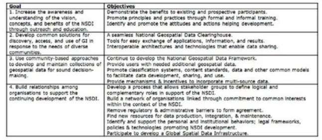
Spatial information infrastructure
Fig. 5.3. NSDI goals and objectives (Source: FGDC) Key elements for success
By 1999, the US NSDI initiative had reached an interesting stage of development in the standards and clearinghouse (metadata) activities but had less success in the framework data (GI content) and in liaison activities between Federal, State and local levels. A number of elements are recognised which facilitated the transformation from an idea to an implementation successful story:
• Leadership: In 1994 President Clinton signed Executive Order 12906 entitled “Coordinating Geographical Data Acquisition and Access: The National Spatial Data Infrastructure”.
• A committee in charge: An inter-agency Federal Geographical Data Committee (FGDC) was set up in 1990 to coordinate “the development, use, sharing and dissemination of surveying, mapping and related spatial data”. The FGDC is based in the National Mapping Division of the US Geological Survey and is chaired by the Secretary of Interior. In 1999 there were 16 staff members.
• Cooperation and partnerships for spatial data activities among the Federal government, State and local governments and the private sector were seen as essential for the development of a robust NSDI.
• A spatial data-sharing program was planned to be established to enrich national spatial data coverage, minimise redundant data collection at all levels, and create new opportunities for the use of spatial data.
• Substantial governmental budgets were used to both manage the process and offer incentives to all interested parties. Money was given to regional consortia through three funding programs: the Cooperative Agreements Program, the Framework Demonstration Projects Program and the NSDI Benefits Program (for more information please refer to http://www.fgdc.gov/funding/urbanlogic_exsum.pdf).
Current issues
Since the mid 1990s, the NSDI has served as an overarching vision for the geospatial community. Beginning as a conceptual construct, the NSDI has evolved into a complementary set of actions implemented by a range of programs dealing with geospatial data and application activities. These programs are managed by government agencies participating in the NSDI and dedicated to achieving the goals of the NSDI. The Federal Geographic Data Committee (FGDC), Geospatial One-Stop (GOS), and The National Map (TNM) are three examples of separate but interrelated activities, contributing to the development of the NSDI.
• Federal Geographic Data Committee (FGDC) – coordinates and facilitates the implementation of the NSDI and related geospatial data activities.
• Geospatial One-Stop (GOS) – “implements the basic elements of the NSDI by providing an Internet portal (www.geodata.gov) to facilitate data sharing for decision support systems and by encouraging partnerships across organizations.”
• The National Map (TNM) – “integrates base geographic data in partnership with content producers at all levels.”
Other current initiatives and programs are designed to facilitate advancement towards the vision of a robust spatial data infrastructure. The initiatives listed below represent only a small sampling of the growing list of programs contributing to the NSDI development.
• HAZUS – a program sponsored by the Federal Emergency Management Agency (FEMA) to develop methodologies and software tools to model and estimate potential hazards from natural disasters such as floods, earthquakes, and hurricanes.
• National Integrated Lands System (NILS) – a partnership between the Bureau of Land Management (BLM) and the US Department of Agriculture (USDA) Forest Service to “develop a common data model and software tools for the collection, management, and sharing of survey data, cadastral data, and land records information.”
• Regional Crime Analysis Geographic Information System (RCAGIS) – an initiative spearheaded by the Department of Justice and the City of Baltimore to develop spatial data and application tools for the regional analysis of crime patterns.
Many key initiatives exist, with varying degrees of partnership, at all levels of government, the private sector, and academia.
Trends, Challenges and Opportunities
Ongoing developments in the public and private sector require the active leadership of a cross-cutting entity to effectively articulate a larger national vision, as well as to guide and coordinate geospatial activities in a manner that best serves national and public interests. Increasing demands for immediate access to accurate and documented geospatial data across agencies and sectors are pushing open-source and standardization initiatives.
Decision support systems that rely on geospatial information have proliferated over the past few years and are increasingly embedded in the operations of government at all levels.
Societal demand for wide-ranging and accurate geospatial data that can be quickly integrated with other data sets is rising. This places a premium on effective geospatial data coordination and sharing. Achieving more cost- effective use of geospatial data requires concerted and creative efforts to adopt common standards and interoperability across agencies and sectors.
Since the advent of the Internet, the Federal government has pursued electronic Government (e-Gov) as a means to more effectively serve the public through electronic information dissemination and web-based services. The nation‟s post-9/11 homeland security efforts have added new urgency to the need for widespread and accessible geospatial data that conforms to uniform interoperability standards for search, discovery, access and metadata documentation. There is concern among stakeholders that many of these initiatives may never reach their full potential without more effective data sharing and coordination within the entire geospatial community - public, private, academic, military and intelligence sectors.
Stakeholders voiced a need for a level playing field in the design and implementation of the NSDI, with an emphasis on true equity and interdependence within the network of NSDI participants at all levels. A corollary to this view is that the FGDC should play the role of a neutral facilitator and convener of stakeholder interests, ensuring that all relevant points of view are accounted for as the NSDI evolves.
The successful development of the NSDI is threatened by the lack of an effectively communicated shared vision and a clear business case for stakeholder participation. Incentives that are misaligned with the needs of stakeholders and the goals of the NSDI can also pose challenges to its development. The continuation of
“isolated” geospatial programs, and the need for agencies at all levels of government to support their specific mission goals, pose an additional challenge to the development of a vital NSDI.
Key factors for ensuring the continued vitality of the NSDI include: a strong business case, accessibility of data and standards, a clear statement of the interrelationship among participants, and a collaborative, open environment (Source: FGDC, 2004).
4.2. 5.4.2 The Dutch NSDI
The concept
Spatial information infrastructure
The Dutch SDI has been defined as “a collection of policy data sets, agreements, standards, technology (hardware, software and electronic communication) and knowledge providing a user with the Geographical Information needed to carry out a task” (Ravi 1995). The creation of such infrastructure has been realised as a way to create new economic opportunities, since it will allow to improve existing services and products, as well as to create new ones that can be exportable. Moreover, the Dutch concept of NSDI puts more emphasis on the process of creating the infrastructure as a way to serve the objectives of the interested parties than on the creation of products. The strong involvement that has been demonstrated by the main GI actors within the creation and development of the Dutch NSDI confirms this philosophy.
The development of the NGII is the responsibility of the Minister of Housing, Spatial Planning and the Environment (VROM) with the assistance of the Netherlands Council for Geographical Information (Ravi) - an independent non-profit organisation, whose main role is to support the Dutch government in matters of Geographical Information. Ravi was founded in 1984 as an advisory board of the Dutch Government and in 1993 was converted into a consultative body that comprises all public services and local authorities with an important role in the provision of real estate and GI.
Three key elements ensure a high political commitment to Ravi activities:
• The VROM minister is the Ravi political coordinator. This institutional arrangement promotes a strong relation between Ravi and the government. Moreover it is possible for Ravi to easily offer asked or unasked advice to the minister.
• Each of the participating authorities has a representative in the Ravi board of directors, which promotes the commitment of each institution within the NGII activities.
• Ravi is also a GI Business Platform on which representatives of private businesses have seats. This promotes cooperation between the public and private sector.
Moreover, the NGII is part of a government strategy for the information society, which is outlined in the BIOS Memorandum and the National Action Program for the implementation of the Electronic Highway (Ravi 1995).
Key elements for success
The Dutch NGII initiative counts on the active involvement of the main GI actors together with a high level of political commitment to its development. These two factors have been key elements to the success of the Dutch NGII development. Moreover, the Dutch NGII is an important element of national information society strategies and Ravi tries to contribute to the realization of the government policy.
The deep involvement of GI actors has allowed Ravi to promote a bottom up policy. For example, the metadata clearinghouse has been developed based on existing metadata services within different GI producers. The Dutch clearinghouse (http://www.geoplaza.nl/) is well developed and is maintained by a private company under the coordination of Ravi. Another strategy followed by Ravi to promote a bottom up approach is to create pilot projects to demonstrate potential benefits to organizations and promote its cooperation.
Additionally, Ravi promotes several projects that intend to promote awareness of the main issues within the GI sector as well as to promote communication among the GI actors. Examples of such projects are the creation of a standardization plan or the organization of workshops on GI accessibility.
Another key element for the success of the Dutch initiative has been the strong relationship that Ravi has promoted with universities and research centres. This relationship promotes awareness of the GI issues and allows creating innovative services and products.
Recent initiatives
To accelerate the development of an NSDI, several projects have been initiated in recent years. We will explain two of them here.
The first project concerns the development of a national geoportal, known as the „National Geo Register‟
(NGR). The goal of this project is to aid the discovery and use of geo-information for professional geo- information users. If the NGR contains sufficient and accurate records of geo-information, it will surely save a lot of time searching for data. Furthermore, it will stimulate innovative ideas and thinking. The geoportal was launched in 2009 and now contains datasets and services from several different Dutch suppliers and
organizations. The NGR is built on open source technology to make it independent of any party. Fortunately, because the NGR makes use of open standards, ArcGIS can consume the contents of the NGR. For example, from a geoportal built with the ArcGIS Server Geoportal Extension, one can search the NGR for data without having to leave the geoportal. For ArcGIS Desktop an additional tool exists, known as the CS-W Client, which makes use of the CS-W standard to search for data in geoportals and catalogues that support this standard.
The second project that started in 2009 is PDOK. This acronym stands for „Publieke Dienstverlening Op de Kaart‟ which can be translated as „public services put on a map‟. The aim is to make geo-information easily accessible for all users, including citizens, through a solid infrastructure. A number of use cases will be demonstrated on spatial planning and on the involvement of society in planning activities. An example of the latter is to encourage people to send geo-tagged photographs of their surrounding environment. In this way, governmental agencies get more grip on what their citizens really think is important.
4.3. 5.4.3 The Finnish example
The concept
The Finnish GII has its origin in the need to share GI within the public administration. In 1985, the Finnish Ministry of Agriculture started a Land Information System project that required shared use of GI among different sectors of the Finnish public administration. One of the objectives of the project was to find ways to facilitate data access and avoid duplication of data collection efforts. Therefore, two of the earliest outcomes of such project were: 1) a metadata directory to describe the existing data, and 2) a draft standard for geometric representation, positioning, positional accuracy and the use of EDIFACT (ISO 9735) data interchange protocol.
As a follow-up of this project, a Consultative Committee for shared use of GI was launched under the umbrella of the Ministry of Agriculture. In 1995, this Committee has developed a strategic document: “The National Geographical Information Infrastructure of Finland: Starting Point and Future Objectives for the Information Society” (http://www.nls.fi/ptk/infrastructure/index.html). One of the main characteristics of the Finish SDI is that participation is always voluntary. Therefore, GI actors‟ involvement within the NSDI is based on their motivation.
Additionally, the National Land Survey of Finland (NLS) was made responsible by law to promote shared use of GI through Finland. Therefore, since 1988, NLS is responsible for developing and maintaining the metadata directory, aside from being in charge of producing the topographic and cadastre data, which is NLS‟s main mission. As a result of its responsibility to promote shared use of data, NLS has invested greatly in the development of data access services through electronic communication networks. In 1999, three services were available online:
• Citizens MapSite - a free service for Finnish citizens. It provides access to seamless topographic maps for the whole country. The search can be done by address, place names or co-ordinates.
• Professional Mapsite - It provides the same service as the Citizen MapSite and in addition gives access to more detailed maps. Access to the more detailed maps is subject to charge. The charging scheme is based on charging a small amount (approximately EUR 0.15) per image loaded.
• MapSite Ordering service - uses the citizen map site service to enable users to define the data and correspondent attributes that they wish to order.
Key elements for success
The Finish NGII is based on a long tradition of centralised data management common to other Nordic countries.
Therefore, Finland has a wealth of detailed data that link socio-economic data to land registry data via their coordinates. This has allowed the NLS to provide data access services for different users based on their needs.
Examples of such services are the Citizen Mapsite and the Professional Mapsite. The creation of services that intend to provide access to GI by citizen demonstrates the well-advanced stage of development of the Finnish GII. Moreover, the Finnish NGII has a well-developed metadata directory, that allows for data discovery and search. The metadata catalogue is maintained by NLS, and it follows a centralised approach that allows for consistency checking.
The role of NLS as spatial data producer and its responsibility for the metadata directory have contributed
Spatial information infrastructure
1) NLS‟ main mission is not to promote the development of GII, 2) it does not have the legal mandate to develop the NGII and 3) NLS does not have required funding to develop the NGII.
Another key element for the success of the Finnish GII are the well developed and wide spread sophisticated telecommunications infrastructure and remote access services, which have promoted the development of the NGII. Moreover, the Finnish information society strategy recognises GI as critical to the development of the society and has explicit links to the NGII strategy.
Present situation
The Finnish NSDI is emerging from well developed premises, it is clear that important components are in place.
Major part of the basic geographic data collection and maintenance in Finland is based on legal roles and tasks of public institutions. The major governmental bodies have practiced active voluntary cooperation and participated jointly in several projects, thereby aiming to avoid overlapping in data collection and at the same ensuring that all necessary themes were covered. The collection of the geographic data has normally been based on common recommendations and guidelines. The building of the Finnish NSDI will be largely been based on this kind of voluntary participation.
Fundamental data sets in the present NSDI-like environment (i.e. in the emerging Finnish NSDI) include national official base registers (real estate register, population register, building register), the national GI data sets (e.g. topographic database, land parcel information system), and various local GI data sets. The common identification system of the base register objects (real estates, buildings, peoples) is advanced. The private sector is providing a non-negligible part of the reference and core thematic datasets (e.g. orthophotos, road networks, utilities). Several well functioning and widely used data services are available.
A number of organizations are particularly active on the GI-scene and contribute to the emerging NSDI. There is the Finnish Council for GI (FCGI) which since has a mandate to develop vision and strategy, the NLS (National Mapping Agency) which is the de facto leading and executive agency for the NSDI, the ProGIS- stakeholder association, the Finnish Environment Institute and some regional or local and transnational initiatives. FCGI includes all the key central government departments, local government and the private sector.
The Finnish Council for Geographic Information was set up 2001 to prepare national GI strategy and to coordinate and follow the NSDI development. The council includes all key central government departments, governmental institutions, local government and the private sector. The council released the first version of the Finnish GI strategy in august 2004 to develop the Finnish NSDI. The Council has actively followed the INSPIRE initiative in the strategy preparation process. In autumn 2004 the GI council started to implement the NSDI strategy according to the agreed development plan and INSPIRE principles.
Data policy relies on good access, state and institution copyrights, use licenses and open pricing principles.
Finland has a long tradition in promoting the shared use of GI. Data sharing between the public administrations is developing gradually to more open direction.
Points where the NSDI situation in Finland admittedly needs further attention include: ensuring the availability of sufficient dedicated resources for the coordination and maintenance of the NSDI; putting in place clear guidelines as to the roles and responsibilities of the players; addressing issues of pricing policies, funding requirements and budget policies; improving the coordinated and adequate use of metadata information to improve data discovery and eventual exploitation (Source: Spatial Data Infrastructures in Finland: State of play 2007, Country report on SDI elaborated in the context of a study commissioned by the EC (EUROSTAT) in the framework of the INSPIRE initiative).
4.4. 5.4.4 NSDI in Hungary
The concept
The Hungarian NGII, although still in an early stage of development, intends to provide public information services with high quality data on spatial location, to support the development of the information society. The basic elements of the NGII have been approved in 1997 at the Inter-governmental Committee on Informatics level under the auspices of the Prime Minister‟s office. This Committee was also responsible for the formulation of a National Spatial Data Policy, which includes the development of the NGII as one important component.
Demonstrating a high political commitment, in 1997 a Working group on Geographical Information was established also under the auspices of the Prime Minister‟s office. This Working Group has representatives from
the interested ministries and several governmental agencies. The following subcommittees have been created to deal with related issues related:
• Concept of the National Strategy on GI
• Cadastral Programme
• Topographic Programme
• Aerial Survey Programme
• Harmonisation and geo-referencing of addresses
• Establishment of a Parcel-based Multipurpose Information System
• Establishment of the Administrative Boundaries Database
• Data dissemination: metadata service and clearinghouse concept
The implementation of these programmes is following different schedules according to the priorities established within each programme. For example, the project of setting up a Data Clearinghouse is still in the definition phase although, the inventory and documentation of existing data sets are in progress taking into account the different standards initiatives and the OGC recommendations. Additionally, two metadata servers have already been set up, METATÉR Server at the Geological Institute of Hungary, (http://metater.gov.hu) and FISH (http://fish.fomi.hu) with a server at the Institute of Geodesy, Cartography and Remote Sensing (FÖMI).
The key elements for establishing a NGII, such as technology, co-ordination and institutional framework, legislative and technical regulations, education and financial support are underway in Hungary, showing an interesting experience on building a NGII within a broader national policy for Geographical Information.
Key elements of success
The Hungarian experience counts on a high level of political commitment that has created a close interagency cooperation. The working group for Geographical Information has representatives from the major stakeholders within the GI sector, which include public administration GI producers but also representatives from the research and development community and from the GI users community (the working group is chaired by the president of HUNAGI - the umbrella organisation for GI). Besides having a strong political commitment this working group also benefits from a legislative framework that supports the establishment of the NGII.
Moreover, European Phare, Tempus and research and development funding are also supporting the development of the NGII.
Additionally, there has been a strong emphasis on raising awareness of GI issues. Several conferences, symposia and workshops have been promoted since the early 90‟s, to collect and discuss the users‟ needs. The implementation of all high priority nation-wide programmes is based on an in-depth analysis of user requirements and feasibility studies.
Activities in the 2010’s
In Hungary, in line with the Act LXXVI/1996 on land surveying and mapping activity and other rules of law, is obligatory to use state land surveying and cartographic basic data (governmental geodata) as a spatial reference for various geoinformation systems. In the world of information technology, it is a basic requirement that these kinds of data should be available in digital form. In the recent years, Hungary has produced significant results in creating framework for the spatial reference systems; the database of horizontal, vertical and 3D (GPS) basic network is ready in 2006.
Nowadays the following maps are available in digital form:
• Cadastral map, rural area: out of the cadastral maps covering the rural area of 8,5 million hectares, the maps covering 6,5 million hectares are already vectorised. According to plans, vectorising of the missing 2 million hectares is completed by September 2005.
• Cadastral maps, urban area: the digital cadastral survey according to DATA Standard for about 500 000
Spatial information infrastructure
• Topographic map products:
Scale Num. of sheets Raster Vector
1:10 000 4098 100% (whole
Hungary)
100 %
1: 100 000 84 100% 100 %
1: 200 000 23 100%
High-resolution digital elevation model (HUNDEM-5), based on vectorized contour lines of 1:10 000 scale topographic maps and stereophotogrammetric measurements for the whole country
At the end of 2006 FÖMI finished the vectorization of planimetric- and hydrographic layers of topomaps at scale 1:10 000, constructing a vectorized data base for the whole country (DITAB-10v.0)
• Satellite images and aerial photographs,
• Digital orthophoto of Hungary (corresponding to scale 1:10 000): Starting from year 2007 instead of analogue camera digital camera is applied for aerial data acquisition. Ground resolution of the digital images 50 cm/pixel.
• Thematic maps, databases produced (among others) in the following topics:
• CORINE Land Cover
• VINGIS vineyard register
• MePAR (Hungarian Land Parcel Identification System – LPIS-Hu) GIS database: The system is based on physical blocks, in 2009 approximately 362 000 physical blocks cover the entire area of Hungary. Since 2007 data recording and physical block system updating are completed annually for 25% of the country.
LPIS integrates more and more thematic layers and data (Less Favoured Areas and the Environmentally Sensitive Areas, vulnerable water bases and nitrate sensitive areas , European Important Bird Areas, High Natural Value Areas)
• Ragweed risk maps
• Flood and waterlog monitoring
Production and use of digital maps need appropriate regulation; DAT (Digital Base Map) Standard and DITAB (Digital Topographic Database) serve this aim. The latter one was produced in cooperation with the Military Map Service (see also the formerly mentioned standards MSZ 7772-1:1997 and MSZ 7772-2:2002).
In the field of developing and operating the information technology in the land offices, the TAKAROS and BIIR systems were installed in the framework of computerisation of land registration. In 2000 the Land Registry IT system (TAKAROS) was completed. TAKAROS system contains an integrated real property registry with the digital cadastral maps. In this system the District Land Office can manage the changes in the legal part data (properties).
In 2003 Network of Land Offices (TAKARNET) was carried out, therefore the Integrated Land Information Services have been available from 2003 via Internet for registered users. TAKARNET network connects all the members of the Hungarian Land Management sector, however, there is a limited public access to the system via Internet. All the registered users of TAKARNET have admittance to any data of the uniform real property registry.
TAKARNET is part of the Main Electronic Government Network (EKG). The external users (nowadays more than 9400 users) can reach the land office data and electronic land office services through this network. The latest land information services started in 2005 on TAKARNET network. All services have been developed by FÖMI (copy of map extracts, watchdog system- change monitoring, countrywide queries in land registry).
Authentic electronic copies of property sheets have been serviced for TakarNet users since 19 March 2008. The users can decide whether they need electronically authorized or non-authentic copies.
5.4. Hungarian NSDI – organisational elements (Source: National Report of Hungary, FIG Congress, Sydney, 2010)
Within the Digital Land Office Programme the first project, the so-called Central Land Office Non-Stop Service System (shortly the TakarNet24) started in December 2008, and will be finished by September 2010. The land registration databases are currently decentralized, i.e. they are kept – in accordance with the principle of territorial competency – in the district land offices. On the TAKARNET – because of operational and security reasons – the external registered clients can have access to land registration data during eight work hours only.
In the TakarNet24 development it is planned to organize the data into a central land office database for data service and archiving purposes, so data maintenance and data supply will be separated. As a result of the TakarNet24 project, hopefully in September 2010, the electronic land registration office services will also be available for the citizens, the wide public. Accordingly, the individuals registered at the Central Client Gate will have access to all the same services (e-authentic and non-authentic electronic copies of property sheets, copies of cadastral maps, change-monitoring etc.) available currently only for registered TakarNet users requesting
Spatial information infrastructure
bulk data. The realisation of this development is the first step towards a modern countrywide hardware system of high technical level for the land registration network.
Hungary – by the Institute of Geodesy, Cartography and Remote Sensing (FÖMI) – takes actively part in international projects like HUMBOLDT, EURADIN, GIS4EU, ESDIN, etc.
5. 5.5 Regional SDI
Regional SDI is an initiative intended to create an environment as an infrastructure that a wide variety of users who require a regional coverage, will be able to access and retrieve a complete and consistent data sets in an easiest and secure way. Its roots are in the regional governments and their cooperation. Having said that, there are many regional organisations and groups that are made up of countries from a particular region. These organisations often cooperate to address common economic, social and environmental issues. The primary purpose of this cooperation is to organise economic activity in such a way as to maximise regional and individual country benefit. Regional and global cooperation presents serious challenges to prevailing ideas about the world being constructed out of a collection of building blocks described as nation-states.
Some of the regional interests that encourage different governments to cooperate with each other in the context of Regional SDI development and also encourage them to form different regional groups, can be summarised as follows: Regional emergency management, Regional mapping, Regional security, Regional access to health care resources, Regional environmental monitoring and management, Shared oceans surroundings, Fishing, Shipping and transport, Economic development and cooperation, Agricultural and forestry management, Partnership (initially with emphasis on technical assistance to the regional members).In order to respond to these regional interests, all regional bodies need to access accurate and consistent regional spatial databases to make the right decisions and to implement and resulting regional initiatives. These databases might need to contain data and information about the whole or part of the region. However, the required databases that contain regional data sets of sufficient accuracy and detail do not exist or are not accessible.
Much geographic data development effort is based on the developer learning from the experience of others. The Regional SDI and its fundamental data sets represent the combined results of such experience. Further benefits of a Regional SDI additional to those already outlined are:
• Reduced costs of data production and elimination of duplication of effort;
• Developing applications more quickly and easily by using existing data and data development standards;
• Provide better data for decision making;
• Save development effort by using fundamental and standardised data, guidelines, and tools;
• Perform analysis, decision making, and operations in cross-jurisdictional areas;
• Expanding market potential and program funding through recognition and credibility as a
• Regional SDI participant;
• Providing consolidated directions to vendors regarding required technical features.
To realise the advantages of a Regional SDI and to speed up its development, at least six key factors should be considered. These factors are:
• awareness of spatial information and SDIs;
• cooperation between the various stakeholders;
• involvement of the politicians concerned;
• knowledge about the type, location, quality and ownership of data;
• accessibility of data sets; and
• the successful widespread use of the data sets.
EUROGI
At the beginning of the 1990‟s representatives of the European GI communities had the vision to create the European dimension for GI. In 1994 an umbrella GI organisation was created with a membership of national and pan-European GI organisations (EUROGI - http://www.eurogi.org). The main goal of this organisation has been to lobby the European Commission and Parliament to generate interest in GI issues and to propose that a political decision should be taken (the GI2000 communication initiative).
GINIE
Geographic Information Network In Europe (GINIE) is a research project funded by the Information Society Technology Programme of the EU for the period November 2001- January 2004. Its partners are EUROGI, the European Umbrella Organisation for Geographic Information, the Open GIS Consortium Europe representing the Geographic Information (GI) industry, the Joint Research Centre of the European Commission, and the University of Sheffield (Coordinator).
The aim of the project was to develop a deeper understanding of the key issues and actors affecting the wider use of GI in Europe, and articulate a strategy to promote such wider use that is consistent with major policy and technological developments at the European and international level. Close attention has been paid to the role of GI in supporting European policies with a strong spatial impact (agriculture, regional policy, transport, environment), e-government, the re-use of Public Sector Information, and the initiative to develop an Infrastructure for Spatial Information in Europe (INSPIRE) .
To achieve its objectives, the project has organised a series of specialist workshops, commissioned analytical studies, collected numerous case-studies of GI in action, and disseminated widely its findings across Europe and beyond. Through its activities GINIE has involved more than 150 senior representatives from industry, research, and government in 32 countries, and contributed in building the knowledge necessary for an evidence-based geographic information policy in Europe. The project presented its findings to a high-level audience of senior decision makers in government, research and industry at its final conference in Brussels in November 2003. Full details and all the project reports are available this site: http://www.ec-gis.org/ginie/documents.html.
INSPIRE
INSPIRE is an abbreviation related to the initiative „Infrastructure for Spatial Information for Europe”. The initiatice came into force on 15 May 2007 (as an official EC directive, see http://inspire.jrc.ec.europa.eu/index.cfm) and will be implemented in various stages, with full implementation required by 2019.
The INSPIRE directive aims to create a European Union (EU) spatial data infrastructure. This will enable the sharing of environmental spatial information among public sector organisations and better facilitate public access to spatial information across Europe.
A European Spatial Data Infrastructure will assist in policy-making across boundaries. Therefore the spatial information considered under the directive is extensive and includes a great variety of topical and technical themes.
INSPIRE is based on a number of common principles:
• Data should be collected only once and kept where it can be maintained most effectively.
• It should be possible to combine seamless spatial information from different sources across Europe and share it with many users and applications.
• It should be possible for information collected at one level/scale to be shared with all levels/scales; detailed for thorough investigations, general for strategic purposes.
• Geographic information needed for good governance at all levels should be readily and transparently available.
• Easy to find what geographic information is available, how it can be used to meet a particular need, and under which conditions it can be acquired and used.
Spatial information infrastructure
6. 5.6 Global Spatial Data Infrastructure
Starting in winter of 1995/96 a group of representatives of the GI community from North America and Europe envisaged the formalisation of the globalisation process for the Geographical Information sector. They identified the need to start sharing experiences between the different emerging NSDI communities and to start looking at the possibility of defining a common vision on how such infrastructures should be implemented to allow interoperability between them.
Since 1996 several conferences have been organised to promote awareness of the concept and the need to develop a GSDI. Moreover these conferences were also important in order to reach an agreement on a GSDI definition and strategies for its development.
Global Spatial Data Infrastructure Association
The GSDI Association is dedicated to international cooperation and collaboration in support of local to global spatial data infrastructure developments that would allow governments, public and private organizations and individuals to better address social, economic, and environmental issues of pressing importance. Its purpose is to focus on communication and networking, capacity building and education, scientific research and applications, and organizational partnership efforts to achieve these aims (Source: www.gsdi.org).
The mission of the GSDI Association is to
• serve as a point of contact and effective voice for those in the global community involved in developing, implementing and advancing spatial data infrastructure concepts and applications,
• foster spatial data infrastructures that support sustainable social, economic, and environmental systems integrated from local to global scales, and
• promote the informed and responsible use of geographic information and spatial technologies for the benefit of society.
The goals of the GSDI Association are to
• support the establishment and expansion of affordable and sustainable local, national, and regional (multi- nation) spatial data infrastructures that are globally compatible,
• provide an organization to foster international communication, networking and collaborative efforts for advancing spatial data infrastructure innovations,
• support interdisciplinary research and education activities that advance spatial data infrastructure concepts, theories and methods;
• enable better public policy and scientific decision-making through spatial data infrastructure advancements and applicability;
• promote the ethical use of and access to geographic information; and
• foster spatial data infrastructure developments in support of important worldwide needs such as improving local to national economic competitiveness, addressing local to global environmental quality and change, increasing efficiency, effectiveness, and equity in all levels of government, and advancing the health, safety and social wellbeing of humankind in all nations.
7. 5.7 Conclusions
The implementation of GII at different scales (local, national, regional and global) is an irreversible movement since availability of geographical data has become a crucial component to improve social and economical development. However, the process of developing and implementing GII is difficult and slow since organisations have enormous staying power and resist change. The vision of a GII is an effort to translate the technical developments of twenty or thirty years into the corresponding change in the organisations.
Another issue that has held back the development of GII at different levels is the lack of a single and consensual definition of GII. More than a single definition, the GI community lacks a common vision of what a GII should be. If more GII processes were formalised and based on agreed definitions then GII would be more rapidly become operational and interoperable. However, there are some consensual principles that everyone can agree on:
• GII started to emerge due to the development of information technologies that allowed managing, manipulating, analysing and retrieving geo-referenced data, namely GIS and Interconnecting Networks.
• GII intend to facilitate access to geographical data in digital format connecting users with data producers. One of the key components to facilitate access to geographical data has been the development of metadata catalogues to document the characteristics of the data.
• The development of GII implies the co-ordination activities within the GI community to avoid duplication of efforts. This implies the development and promotion of standards and procedures to regulate the production, maintenance and exchange and access to GI.
• Geographical data and users are the GII main components.
The most important rule of thumb to develop GII is that each system should be implemented according to its specificities, for instance, if there is no data available in digital format no GII can be developed. Additionally, each technical decision on how to implement GII should also be based on the users needs and market characteristics. Moreover, local infrastructures have different needs than national infrastructures and they have different needs than the regional or global infrastructures. Their needs are different both in available digital data and technical expertise.
Worldwide there is a growing acceptance that global and regional GII should be based on NGII and local GII need a political, organisational and technical orientation provided by the NGII of that nation.
It is important to underline that major factors for GII success are the political decision and support, the governmental resources assigned to the GII development effort and the involvement of the public sector. As described above the most advanced processes of implementing GII have secured this political leadership.
Moreover, important efforts have to be made to prepare the arguments to convince politicians of the need for GII.
8. 5.8 Summary
This module pointed out the general goals and necessary processes for SDI / GII. From the module you become familiar with the the roots and current development of Spatial Data Infrastructures (SDI) / Geographical Information Infrastructures (GII) at the national, multi-country and global levels; the vision and benefits of NSDI and how to get there.
After learning of this chapter, you will be able to:
• define what a GII is,
• explain, why GII are important and why effort should be put into developing them,
• give a short overview of the history on the development of GII,
• give examples of GII at the national, regional and global level.
Review questions
• Introduce the roots of SDI and GII!
• Specify the the USA NSDI!
• Summarize the results and current issues of NSDI in USA!
• Introduce the Dutch example!
Spatial information infrastructure
• What is the present situation in Finland?
• Introduce the Hungarian NSDI!
• What are the needs for a regional SDI?
• How Europe is building its regional SDI?
• Explain the role and mission of GSDI Association?
Bibliography
1. Ed. Frank A. - Raubal M. - van der Vlugt M.:
2. Burrough, P. - Masser, I.: European Geographic Information Infrastructures. London, Taylor & Francis, 1998
3. BEST-GIS: Guidelines for best practice in user interface for GIS, GISIG, EU ESPRIT project, 1998 4. Bowman, C.: Stratégiai menedzsment, Panem, Budapest, 1998
5. Kieser, A.: Szervezetelméletek, Aula, Budapest, 1995