Geoinformation management 6.
Standards and interoperatibility
Béla Márkus
Created by XMLmind XSL-FO Converter.
Geoinformation management 6.: Standards and interoperatibility
Béla Márkus Lector: János Tamás
This module was created within TÁMOP - 4.1.2-08/1/A-2009-0027 "Tananyagfejlesztéssel a GEO-ért"
("Educational material development for GEO") project. The project was funded by the European Union and the Hungarian Government to the amount of HUF 44,706,488.
v 1.0
Publication date 2011
Copyright © 2010 University of West Hungary Faculty of Geoinformatics Abstract
The module is dealing with the types and benefits of standards, the need for interoperatibility; it focuses attention on GI related standards in particular the European Committee for Standardization (Comité Européen de Normalisation - CEN), International Standardisation Organisation (ISO) and Open Geospatial Consortium (OGC) activities.
The right to this intellectual property is protected by the 1999/LXXVI copyright law. Any unauthorized use of this material is prohibited. No part of this product may be reproduced or transmitted in any form or by any means, electronic or mechanical, including photocopying, recording, or by any information storage and retrieval system without express written permission from the author/publisher.
Table of Contents
6. Standards and interoperatibility ... 1
1. 6.1 Introduction ... 1
2. 6.2 Types and benefits of standards ... 2
2.1. 6.2.1 Classification by legal status ... 2
2.2. 6.2.2 Classification by function or by origin ... 2
2.3. 6.2.3 Benefits of standards ... 3
3. 6.3 Interoperability ... 4
4. 6.4 Need for interoperability and standards ... 6
5. 6.5 Standards for GIS interoperability ... 7
5.1. 6.5.1 The European Standardisation - CEN/TC 287 ... 8
5.2. 6.5.2 The OGC Standards ... 9
5.3. 6.5.3 ISO/TC 211 Geographic Information Standards ... 11
6. 6.6 Conclusions ... 12
7. 6.7 Summary ... 13
Chapter 6. Standards and interoperatibility
1. 6.1 Introduction
The module is dealing with the types and benefits of standards, the need for interoperatibility; it focuses attention on GI related standards in particular the European Committee for Standardization (Comité Européen de Normalisation - CEN), International Standardisation Organisation (ISO) and Open Geospatial Consortium (OGC) activities.
In the 1990‟s there was a clear movement from a national to a global dimension for the standardisation of Geographical Information (GI) and Geographical Information Systems (GIS) at the same time has also seen the emergence of greater interoperability requirements.
Standardisation in the GIS community was initially a standardisation of data exchange formats. The exchange of data between the proprietary GIS of the 80‟s and early 90‟s (closed GIS) was a permanent difficulty and users demanded standardised exchange formats, which all GIS could read and write.
In Europe, GI standardisation efforts that had been made by national standardisation bodies (such as AFNOR in France, BSI in the UK and DIN in Germany) were relayed from 1992 by a European effort made by the CEN.
Since 1994 the ISO has been working on similar topics.
From early 70‟s GI sector activities resulted in the development of independent complex GIS based on proprietary data formats and the production of GI based on independently developed specifications. It was obvious at the beginning of the 1990s that the GI community had to tackle this non-interoperable schema to facilitate the work of the end users and to improve efficiency.
The movement towards a higher level of interoperability in the GI sector is led by:
• institutional standard makers who focus activities on the data part of the problem,
• industrial specification makers who focus activities on systems, and
• umbrella and co-ordinating organisations that focus activities on the institutional and organisational dimensions.
With the advent of widespread networking, users realised that data exchange was not sufficient. Downloading data from a provider resulted in having a copy of the data, which was not updated anymore. To have up-to-date data in the future it was necessary to download the data again and again. The better solution would be to access only the subset of data one needs for a single operation and not copy the full dataset. If an application program can automatically converse with a data provider and access the updated data on the provider‟s server (“life data”) then the two programs are interoperable.
In parallel to these activities, a process of defining GIS related specifications aimed at providing interoperability between GI systems was started in 1994 with an industry focus in the Open GIS Consortium1 (OGC).
From the module you become familiar with the:
• types and benefits of GIS standards; and
• the basics of interoperatibility issues.
After learning of this chapter, you will be able to:
• classify the standards;
1 Its name was changed to Open Geospatial Consortium in the last decade. The Open Geospatial Consortium, Inc.® (OGC) is a non-profit, international, voluntary consensus standards organization that is leading the development of standards for geospatial and location based services.See more at www.opengeospatial.org
Standards and interoperatibility
2
Created by XMLmind XSL-FO Converter.
• explain the benefits of standardisation;
• define the basic concepts of standardisation in the field of geospatial information,
• specify the need for interoperability and standards;
• introduce the GIS standardisation bodies.
2. 6.2 Types and benefits of standards
2.1. 6.2.1 Classification by legal status
Standards underpin all forms of business. They range from informal agreements between partners, through internal codes of practice and guidelines, to formal requirements recognised in law (Source: www.bsigroup.org).
Examples include:
• de facto or informal standards, produced by the unaided market,
• de jure standards, developed formally by recognised organisations,
• regulatory standards, produced as part of the regulatory process.
Informal Standards
An informal standard can be something as simple as a guideline on how to answer telephone calls or a trade association‟s code of practice for its members. Whether devised for application within a single organisation or arising across an industry, such standards can bring many business benefits through improved interoperability and market access.
Businesses, associations or organisations can develop their own informal standards or employ external consultants, to help them.
Formal Standards
Formal standards are publicly available documents, established by a broad consensus of industry experts and representatives of government, business and society. They include technical standards, used by business to align products or services with market or regulatory needs, and Quality-Management System standards (QMS), which establish best practice for the management of processes.
Regulatory Standards
Some laws and regulations might refer to certain standards, or use them as the simplest way of showing compliance. Of particular value to business is goal-based regulation, whereby government criteria can be met though the collaborative development and application of standards. This flexible system allows businesses to conform in the most appropriate and efficient manner.
2.2. 6.2.2 Classification by function or by origin
Classified by function or by origin, there are eight basic types of standards:
• Basic standards
Primary or fundamental standards for weights and measures (legal metrology) have been around since the early days of civilization.
• Product standards
There are standards for the physical, chemical, electrical and mechanical characteristics of products and materials. Product standards establish conformity and interoperability by defining dimensions and qualities such as shape, volume, speed, etc.
Standards and interoperatibility
Examples of product standards are those for 35 mm film, banking, credit and telephone cards. Environmental product standards specify, within various tolerances, the physical or chemical properties of a product, such as the limits on contaminants in food products, noise standards for consumer appliances and emissions levels for automobiles.
Product standards can be classified as either defining performance criteria or design criteria. Performance standards specify the level of expected performance for a product and may include test methods that simulate performance under actual conditions (e.g. clothing textiles are tested and regulated for flammability).
• Design standards
Design standards specify the design or technical characteristics of a product in terms of how it is to be constructed.
• Process standards
Process standards are concerned with the series of actions or operations used in making a product and provide the methodology to perform these processes in a consistent and reproducible way.
• Specifications
A specification is a set of conditions and requirements of precise and limited application that provide a detailed description of a procedure, process, material, product, or service for use primarily in procurement and manufacturing. Standards may be referenced or included in specifications.
• Codes
Codes are collections of mandatory standards that have been codified by government authorities and become law.
• Management System Standards
Management system standards specify requirements that can be applied to any organization, regardless of the product it makes or the service it performs. Two of the most widely known series of international standards that fall into this category are:
• the ISO 9000 series for managing quality systems and
• the ISO 14000 series for environmental management systems.
The ISO 9000 standards are designed to help companies improve the manufacturing process and set up quality systems in the design, development, production, installation, testing, inspection and servicing of products.
The ISO 14000 standards provide guidance on several aspects of environmental management, including environmental auditing, performance evaluation and life cycle assessment.
• Personnel Certification Standard
Personnel certification programs help to verify that individuals have the necessary knowledge, skills and abilities to perform their work. Certification of personnel provides continual improvement in professional competence and leads to a highly skilled workforce, particularly within industries that have an impact on public safety such as food protection.
Global recognition of these programs increases the potential for national and international reciprocity of certified individuals and creates an internationally recognized framework and evaluation system.
The international standard, ISO/IEC 17024, has been developed to achieve and promote a globally accepted benchmark for bodies managing the certification of persons (Source: www.standardslearn.org).
2.3. 6.2.3 Benefits of standards
Standards and interoperatibility
4
Created by XMLmind XSL-FO Converter.
Standards are a powerful tool for businesses of all sizes, supporting innovation and increasing productivity.
Effective standardization promotes competition and enhances profitability by increasing efficiency and enabling businesses to take a leading role in shaping the industry itself.
In modern business, effective communication along the supply chain and with legislative bodies, clients and customers is imperative. Standardization can deliver measurable benefits when applied within the infrastructure of a company itself. Business costs and risks can be minimised, internal processes streamlined and communication improved. Standardization promotes interoperability, providing a competitive edge necessary for the effective worldwide trading of products and services.
Standards allow businesses to:
• attract and assure customers,
• demonstrate market leadership,
• create competitive advantage,
• develop and maintain best practice.
Market Access
Introducing standards can help businesses to retain existing clients and generate sales from new customers, while easing the process of regulatory conformity through:
• removal of trade barriers,
• a flexible, cost-effective means of complying with regulations,
• maximising revenue via optimised market access.
Marketing tool
The ability to demonstrate compliance with widely recognised and respected standards is an effective means of differentiation in a competitive marketplace. In addition, manufacturing products or supplying services to appropriate standards maximises their compatibility with those manufactured or offered by others, thereby increasing potential sales and widespread acceptance.
Promoting Innovation
Standards provide support for innovation from original concept through to market. The shared knowledge and network benefits they afford help reduce costs and associated risks, allowing a business to:
• increase speed to market
• create interoperability
• shape and develop a new market Best Practice
The application of standards within a business serves to streamline internal and external operations and strengthen the consistency of processes. Business benefits can be gained through:
• eliminating wasteful investments of time and resources
• increased internal productivity and quality of communication
• reduced duplication of effort and improved risk management
3. 6.3 Interoperability
Standards and interoperatibility
Interoperability2 is a property referring to the ability of diverse systems and organizations to work together (inter-operate). The term is often used in a technical systems engineering sense, or alternatively in a broad sense, taking into account social, political, and organizational factors that impact system to system performance.
While interoperability was initially defined for IT systems or services and only allows for information to be exchanged (see definition below), a more generic definition could be this one:
Interoperability is a property of a product or system, whose interfaces are completely understood, to work with other products or systems, present or future, without any restricted access or implementation.
This generalized definition can then be used on any system, not only information technology system. It defines several criteria that can be used to discriminate between systems that are "really" inter-operable and systems that are sold as such but are not because they don't respect one of the aforementioned criteria, namely:
• non-disclosure of one or several interfaces
• implementation or access restriction built in the product/system/service The IEEE Glossary defines interoperability as:
the ability of two or more systems or components to exchange information and to use the information that has been exchanged.
Syntactic interoperability
If two or more systems are capable of communicating and exchanging data, they are exhibiting syntactic interoperability. Specified data formats, communication protocols and the like are fundamental. XML or SQL standards are among the tools of syntactic interoperability. This is also true for lower-level data formats, such as ensuring alphabetical characters are stored in ASCII format in all the communicating systems.
Semantic interoperability
Syntactical interoperability is a necessary condition for further interoperability. Beyond the ability of two or more computer systems to exchange information, semantic interoperability is the ability to automatically interpret the information exchanged meaningfully and accurately in order to produce useful results as defined by the end users of both systems. To achieve semantic interoperability, both sides must refer to a common information exchange reference model. The content of the information exchange requests are unambiguously defined: what is sent is the same as what is understood.
Interoperability and Open Standards
Interoperability must be distinguished from Open Standards. Although the goal of each is to provide effective and efficient exchange between computer systems, the mechanism for accomplishing that goal is very different.
Open Standards imply interoperability ab-initio, i.e., by definition, while interoperability does not, by itself, imply wider exchange between a range of products, or similar products from several different vendors, or even past future revisions of the same product. Interoperability may be developed post-facto, as a special measure between two products, while excluding the rest, or even when the vendors of the two 'interoperable' products are forced into a dominant/submissive or exploitative relationship vis-a-vis themselves or their customers.
Open Standards
Open Standards rely on a broadly consultative and inclusive group including representatives from vendors, academicians and others holding a stake in the development. That discusses and debates the technical and economic merits, demerits and feasibility of a proposed common protocol. After the doubts and reservations of all members are addressed, the resulting common document is endorsed as a common standard. This document is subsequently released to the public, and henceforth becomes an open standard. It is usually published and is available freely or at a nominal cost to any and all comers, with no further encumbrances.
Various vendors and individuals (even those who were not part of the original group) can use the standards document to make products that implement the common protocol defined in the standard, and are thus
2 This chapter is based on Wikipedia
Standards and interoperatibility
6
Created by XMLmind XSL-FO Converter.
interoperable by design, with no specific liability or advantage for any customer for choosing one product over another on the basis of standardised features. The vendors' products compete on the quality of their implementation, user interface, ease of use, performance, price, and a host of other factors, while keeping the customers data intact and transferable even if he chooses to switch to another competing product for business reasons.
eGovernment
Speaking from an eGovernment perspective, interoperability refers to the collaboration ability of cross-border services for citizens, businesses and public administrations. Exchanging data can be a challenge due to language barriers, different specifications of formats and varieties of categorisations. Many more hindrances can be identified.
If data is interpreted differently, collaboration is limited, takes longer and is not efficient. For instance if a citizen of country A wants to purchase land in country B, the person will be asked to submit the proper address data. Address data in both countries include: Full name details, street name and number as well as a post code.
The order of the address details might vary. In the same language it is not an obstacle to order the provided address data; but across language barriers it becomes more and more difficult. If the language requires other characters it is almost impossible, if no translation tools are available.
Hence eGovernment applications need to exchange data in a semantically interoperable manner. This saves time and money and reduces sources of errors. Fields of practical use are found in every policy area, be it justice, trade or participation etc. Clear concepts of interpretation patterns are required.
Many organisations are dedicated to interoperability. All have in common that they want to push the development of the World Wide Web towards the semantic web. Some concentrate on eGovernment, eBusiness or data exchange in general. In Europe, for instance, the European Commission and its IDABC programme issue the European Interoperability Framework. They also initiated the Semantic Interoperability Centre Europe (SEMIC.EU).
A European Land Information Service (EULIS) was established in 2006, as a consortium of European National Land Registers. The aim of the service is to establish a single portal through which customers are provided with access to information about individual properties, about land and property registration services, and about the associated legal environment.
In the United States, the government's CORE.gov service provides a collaboration environment for component development, sharing, registration, and reuse and related to this is the National Information Exchange Model (NIEM) work and component repository.
4. 6.4 Need for interoperability and standards
Implementing GIS involves defining a data model that represents the real world spatial and non-spatial data. The data model defines the objects, their attributes, and inter-relationships. The scope of the data model may vary depending on the sophistication and required functionality of the software. Developing data models is by large the most critical and time consuming step in developing software.
Many software solutions have been developed during the last decade in an attempt to improve the GI processes.
However, the majority of these tools were developed to operate as stand-alone systems to support a particular task with limited or no capability to share and exchange information with other systems. Also, each tool typically used a proprietary data model and stores data in a proprietary file format which, in most cases, cannot be accessed by or shared with other software tools. Standardizing the representation of data would enable these different systems to interoperate (i.e. to share and exchange data), and thus provide users of these systems the capability to reuse existing data, coordinate work processes, and share vital information in an efficient and effective manner.
Without data standards, integrating different software tools into an integrated system requires implementing adapters to translate the ad-hoc data models, that different tools use, to and from proprietary data models. A standard data model would facilitate efficient data sharing and exchange, and improve the consistency and quality of asset information.
Standards and interoperatibility
Spatial data constitute the core of geoinformation systems and are central to many activities and decision- making processes in general. The majority of data can be related to some form of spatial data. It can be argued that the development of standard data models for GI applications will have to be founded upon comprehensive and standardized spatial data models. A spatial data standard would serve as the foundation for the specification of comprehensive data models for GI systems. Therefore, developing or adopting a vendor-neutral standard for spatial data is the first step towards developing standard data models for GI systems. After adopting or developing such standards, future work may focus on augmenting the spatial data models with specific nonspatial data elements of particular assets classes, for example linking condition data to spatial data.
To any organizations, spatial data needs to be accessed, not only by its own employees, but also by several other organizations and agencies such as utility companies. Similarly, an engineer might need to access spatial data stored and managed by other organizations. Adopting a standardized data model and format will enable various organizations to access, use, and disseminate spatial data in a common and consistent manner. A standard data model provides the means of data “reusability” between different software tools and organizations. It also helps to eliminate the duplication of efforts in collecting and developing spatial data. Consultants and contractors can make their data compatible with the standards, and hence, make these data readily available and reusable for maintenance and operations management.
By standardizing the data semantics and format, a standard data model ensures the integrity and consistency of the data across various disciplines involved throughout the life cycle of related objects. The standard data model will provide common definition of the asset data (e.g. entities, attributes, units of measurements, data quality metrics). The standard will also promote data consistency and enable the effective creation, use, management, and automation of data. Sharing spatial data between GI systems and other enterprisewide systems (e.g. ERP) or other maintenance management systems can also be aided by using standard spatial data models. When a data model is standardized and endorsed by major bodies in the industry, software vendors try to make their products and solutions compatible with these standards, which further ensures data consistency and the interoperability between different systems.
In their effort to integrate and streamline their work processes, many organizations want to ensure that their existing computer applications can interoperate and exchange information in an efficient manner. Standardized data can be easily accessed and integrated with various function specific applications such as cost estimating, operation management, and maintenance planning applications. Adopting a standard data model and format enables organizations to better streamline and coordinate their work processes by integrating data across different functionspecific software tools.
A major advantage of using GIS is its capability to integrate spatial data from different sources that could exist across several organizations. For example, creating a complete map of a specific organization would require overlaying different layers to show infrastructure, utilities, and land information for that area. Again, integrating and linkingspatial data from different sources requires the use of a consistent and standardized spatial data model that could enable linking and exchanging spatial data regardless of the software or hardware used, or the method by which the data was created. This will be particularly useful when spatial data is shared and exchanged over the Internet.
The life cycle of data is extremely long compared to the life span of any data model, format, or software technology. Software systems and proprietary data formats typically go through extensive changes and upgrades, which may render their use after few years a cumbersome task that requires the use of special vendor- specific software to translate from older data models/formats to newer ones. The use of an open, standard, and neutral data format is one way to ensure that the data created will likely survive the changes in software or data technologies.
Finally, a spatial data standard is a key to the development of a spatial data infrastructure at the local, national, or international levels.
5. 6.5 Standards for GIS interoperability
Data modeling standards, in general, define structures and semantics as well as mechanisms for modeling and exchanging information. In the context of GIS, a data model would specify the structure and organization of spatially related information, including the representation of both graphic and non-graphic data. Spatial data address primarily the content and accuracy of the positional and attribute data of spatial features. In general, exchanging data between different GIS systems is currently being achieved in two main ways:
Standards and interoperatibility
8
Created by XMLmind XSL-FO Converter.
1. Through the use of special-purpose tools to translate the data between different formats and data models.
Many GIS systems use de-facto file format standards developed by vendors. Examples include ESRI Shape File format and Autodesk DWG/DXF format. Data translators map the data between different systems and typically involve a tremendous amount of redundant data extraction, interpretation, and re-entry by the end users. This process is known to be inefficient, time-consuming, and prone to inconsistencies due to mapping and/or interpretation errors. Also, the tool-specific nature of the translators imposes unnecessary constraints on end users by requiring the use of proprietary vendor-specific data models and software systems. Lack of industry wide standard data models has been viewed as the main cause of these deficiencies.
2. Through accessing a set of APIs (application programming interfaces) or software components (e.g. COM components). Many commercial applications offer API interfaces to allow other applications to access the internal data model and to input or extract data directly to and from the application. Although some of these APIs may be an industry defacto standard (such as COM or the Open Database Connectivity, ODBC), the majority of the APIs in GIS software are proprietary and tool-specific. As a result, this form of vendor- specific API-based interoperability is also limited.
Due to the inherent limitations of the two aforementioned methods of data exchange, there has been a wide consensus in the industry and research community that the use and adoption of vendor-neutral industry-wide standard data models and formats constitute the most viable option for software interoperability. The standard data models define common semantics of the data as well as a vendor-neutral file format to exchange these data.
The standard data models would also need to meet the diverse requirements of the various disciplines of all potential users, and should be based on industry wide consensus.
During the past decade, there have been several efforts to standardize GIS spatial data models and format.
Parallel to these efforts, several software vendors and researchers have been developing data models for GI applications in various domains. Many of these data models have now reached a level of maturity that could enable their wide use and adoption as standard data models in the industry. For example, ESRI has provided users with application-specific data models in many different application domains such as water utilities, energy utilities, land parcels, and transportation networks3. However, vendor-specific data models are not generally intended to enable interoperability with other software systems. Rather, the main purpose of these vendor- specific data models is to simplify and expedite the process of implementing GIS systems using the vendor‟s toolset by providing ready and tested data models. Another reason is to promote the use of a consistent data model within a particular application domain based on the vendor‟s software suite.
The following three sections provide an overview of some of the efforts most relevant to the issue of standardizing spatial data in GIS systems, with a primary focus on GIS systems. The European Committee for Standardization CEN/TC 287 standards, the Open Geospatial Consortium (OGC) standards, and the International Organization for Standardization (ISO) standards will be introduced briefly. No attempt is made to cover the specifications involved with these spatial data standards, but rather to discuss the main parts of these standards that are most relevant to the development of a GIS.
5.1. 6.5.1 The European Standardisation - CEN/TC 287
CEN's mission4 is to promote voluntary technical harmonisation in Europe in conjunction with worldwide bodies and its partners in Europe. Harmonisation diminishes trade barriers, promotes safety, allows interoperability of products, systems and services, and promotes common technical understanding.
CEN Technical Committees (TCs) gather the national delegations of experts convened by CEN National Members, which must make sure that such delegations convey a national point of view that takes account of all interests affected by the work. Technical Committees must take into account any relevant work (in ISO, for example) falling within its scope, as well as any data that may be supplied by CEN National Members and by other relevant European / International organisations. The results of this work can then be offered to ISO.
There is more than one category of CEN standard. The original intention of CEN/TC 287 was to create a family of standards known as „EN‟: Euro-Norme or European Standards. Members are obliged to implement 'EN' European Standards by giving them the status of national standard.
3 http://www.esri.com/software/arcgis/geodatabase/data-models.html
4 http://www.cen.eu/cen/AboutUs/Strategy/Pages/default.aspx
Standards and interoperatibility
For a number of reasons, mostly relating to the later decision to set up an ISO technical committee, the members of CEN/TC 287 decided that the standards would be „ENV‟: Euro-Norme Voluntaire or European Prestandards.
ENVs are established as prospective standards for provisional application in technical fields where the innovation rate is high or where there is an urgent need for guidance. ENVs do not have to be adopted by the members (but they must be announced and made available).
A difference between the two is that European procurement law mandates that contracts above the various minimum limits shall adopt EN standards unless both parties mutually and amicably agree otherwise. The decision by CEN/TC 287 to produce ENVs means that adoption of its results is entirely a national decision.
It has been mentioned that work prior to the creation of CEN/TC 287 pointed towards the need to modularise the typical data exchange transfer standard so that the resulting 'family of standards' would be more flexible. They would then be able to adapt to the evolution in information and communications technologies as well as to specific GI market needs. This was a significant change but the concept was little understood or appreciated by the community that it aimed to satisfy.
The conventional approach to modularising information technology standards is to construct a Reference Model:
the CEN/TC 287 model shows how the standards may be used in the various contexts supported by it. Among these is a data provider/data procurer concept that relies on unspecified electronic commerce activities to be implemented.
5.2. 6.5.2 The OGC Standards
The Open Geospatial Consortium was founded in 1994 with the goal “to provide a single 'universal' spatio- temporal data and process model that will cover all existing and potential spatio-temporal applications; to provide a specification for each of the major database languages to implement the OGIS datamodel; and to provide a specification for each of the major distributed computing environments to implement the OGIS process model” (www.opengeospatial.org). The OGC standards aim to support the development of a single integrated infrastructure that is vendor-, technology, and platform independent.
Heterogeneous and distributed GIS systems complying with the standards can transparently communicate and exchange spatial data. OGC standards are widely accepted in the industry and are already supported by many software vendors.
The OGC develops two main sets of standards: abstract-level and implementation-level specifications. The specifications define a set of interfaces that can support standardized access to distributed spatial data and processes, and thus enables the interoperability and integration of spatial data resources across the Internet.
Abstract Specifications define conceptual data models and interfaces that can be used to develop more detailed implementation specifications. Implementation Specifications, on the other hand, are a detailed and unambiguous description of software system Application Programming Interfaces (API) that are based on the abstract standards. The OGC standards also define a set of services and metadata standards to enable the discovery and access of spatial data and services across the Internet. The OGC reference architecture has adopted an XML-based web services model for integration and interoperability of different spatial data resources and data processing systems. According to OGC‟s definition, web services are “... self-contained, self- describing, modular applications that can be published, located, and invoked across the Web. Web services perform functions that can be anything from simple requests to complicated business processes. Once a Web service is deployed, other applications (and other Web services) can discover and invoke the deployed service."
Abstract Specifications
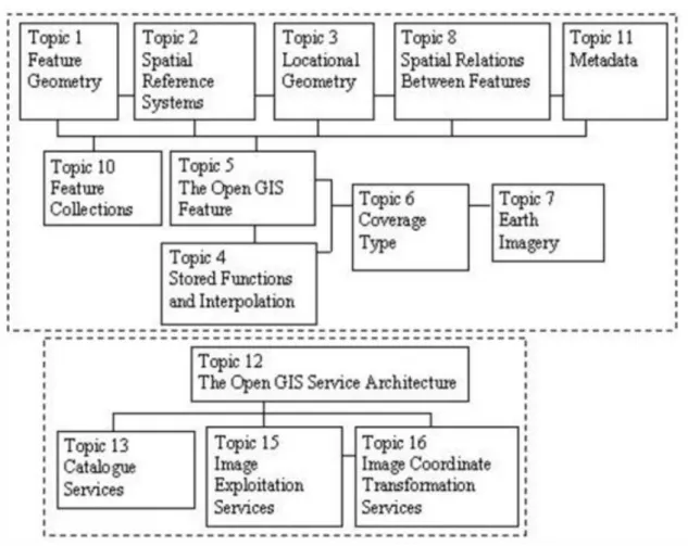
The OGC abstract specifications are organized into topics and each topic is developed and overseen by a separate Working Group. The abstract specifications can generally be categorized into two main groups. The first group focuses on standardizing the data models to enable sharing spatial data and interoperability between different systems, while the second group focuses on specifying interfaces (or APIs) of web services to enable interoperability of distributed spatial systems in a plug-and-play fashion. This second group includes topics 12, 13, 15, and 16, while the first group includes all other topics. The next figure shows the relationship between the different topics in each group.
Topic 1 provides the geometry data structures for spatial features. This topic standard was adopted by ISO/TC 12 and became known as ISO 19107.
Standards and interoperatibility
10
Created by XMLmind XSL-FO Converter.
Topics 2 and 3 deal with the area of geographic or spatial location in two different domains: Topic 2, Spatial Referencing by Coordinates, provides the Spatial Reference Systems by which features are related to positions on earth by coordinates, while Topic 3, Locational Geometry Structures, defined methods for providing spatial referencing models for GIS systems.
Topic 8 deals with defining and modeling of spatial relationships between features.
Topic 11 provides for the modeling and query of metadata. Topics 1, 2, 3, 8, and 11 directly support Topics 5, 6, and 7.
Figure 6.1: Relationship of OGC Abstract Specification Topics (Source: Vanier, 2004)
Topics 5, 8, and 10 discuss the modeling of spatial information using features. Topic 5 discusses the use of features to model real-world spatial objects. A feature object corresponds to a real world or abstract entity.
Topic 8, Relationships between Features, describes an abstraction for the relationships between features. Topic 10, Feature Collections, describes an abstract object consisting of a collection of Feature Instances and their Feature Schema.
Topics 6 and 7 are focused on modeling spatial information using Coverages and Earth Imagery. The Coverage is a special case of an OGC Feature, while an Earth Image, in turn, is a special case of a Coverage.
Topics 12, 13, 15, and 16 of the Abstract Specifications are primarily concerned with standardizing geospatial services, while other topics address the standardization of the spatial data models.
Topic 12, the OGC Service Architecture, specifies a comprehensive set of geospatial services such as the Web Map Server, the Web Feature Server, the Web Coverage Server, the Web Annotation Server, and the Web Catalogue Server. Topic 12 has become ISO 19119. Topics 13, 15 and 16 describe specific categories of spatial services.
Topic 13 describes catalogue and information access services; Topic 15 describes the categories of image exploitation services needed to support the use of images and certain related coverage types; and Topic 16 describes the image coordinate transformation services.
Standards and interoperatibility
Implementation Specifications
The OGC implementation specifications provide detailed description of software systems API which enable software developers to build software that can plug-and-play with other standardcompliant systems. To promote and support the implementation effort of the standards, OGC has adopted a program, called the Interoperability Program, to implement, test, and refine these interfaces through the development of a series of pilot projects and test-beds.
The implementation specifications describe the schemas for web services interfaces, outlined in Topic 12 in the abstract specifications, and the Geographic Markup Language (GML). GML provides a set of XML-based schemas to the modeling and encoding of spatial and non-spatial attributes of objects in GISs. Example schemas include geometry for spatial features (0, 1, or 2 dimensional), coordinate reference systems, topology, and coverages, among others. Schemas for GML and various services can be accessed at (schemas.opengis.net).
Being an XML-based technology, GML is particularly useful to enable the integration, sharing, and interoperability of GIS data and software across the Internet. GML is intended to be generic enough to enable the definition of domain-specific schemas. The current GML version is 3.0.1, was released in June 2003. Most major GIS vendors have already started supporting GML in their products. Also, several software products are implementing support for OGC Web Service interfaces and can serve spatial information as GML documents.
Many GML-based schemas can be accessed at (schemas.opengis.net/gml).
5.3. 6.5.3 ISO/TC 211 Geographic Information Standards
ISO/TC 211 develops and oversees the development of international standards for representing and exchanging digital geographic information used in GIS. These standards provide specifications for the methods, tools and services for managing, acquiring, processing, analyzing, accessing, and presenting spatial data (www.isotc211.org). The standards also provide a framework for developing interoperable spatial applications where spatial data can be shared and exchanged between different systems. The committee includes representatives from 33 participating countries and 17 observing countries, and many external observer organizations such as OGC. A complete list of approved and under development standards can be accessed at the committee‟s web site. Currently, work is ongoing to develop about 32 spatial data standards.
ISO/TC 211 has about 40 different standards in active development. Up until now, the committee has defined about 9 international standards (IS) and 10 draft international standards (DIS), while the remaining is still under preparation. A complete list of these standards with brief description can be accessed at (www.isotc211.org/scope.htm). The first ISO/TC 211 standard in the series was published in 2000. The existing IS and DIS are listed below.
International Standards
International Standards (IS) include the following
• ISO 19101: Reference model (published in 2002)
• ISO 19105: Conformance and testing (published in 2000)
• ISO 19107: Spatial schema (published in 2003)
• ISO 19108: Temporal schema (published in 2003)
• ISO 19111: Spatial referencing by coordinates (published in 2003)
• ISO 19112: Spatial referencing by geographic identifiers (published in 2003)
• ISO 19113: Quality principles (published in 2002)
• ISO 19114: Quality evaluation procedures (published in 2003)
• ISO 19115: Metadata (published in 2003) Draft International Standards
Standards and interoperatibility
12
Created by XMLmind XSL-FO Converter.
The Draft International Standards (DIS) include the following:
• ISO 19104 - Terminology
• ISO 19106 - Profiles
• ISO 19109 - Rules for application schema
• ISO 19110 - Feature cataloguing methodology
• ISO 19112 - Spatial referencing by geographic identifiers
• ISO 19116 - Positioning services
• ISO 19117 - Portrayal
• ISO 19118 - Encoding
• ISO 19119 - Services
• ISO 19125 - Simple feature access – Part 1-2
The most important ISO/TC 211 standards for municipal GIS applications are: ISO 19107 Spatial schema, ISO 19115 Metadata, ISO 19111 Spatial referencing by coordinates, and ISO 19112 Spatial referencing by geographic identifiers. These standards can be directly implemented in municipal GIS systems.
ISO/TC 211 standard data models are defined using the Unified Modeling Language (UML). The UML models of the defined standards can also be accessed on the committee‟s web site at (www.isotc211.org/hmmg/HTML/root.html).
In 1999, the ISO/TC 211 and OGC signed a cooperative agreement in order to harmonize and integrate the standardization efforts of the two organizations. As a result, ISO has adopted a number of OGC specifications.
Most notable is the OGC‟s Spatial Schema (ISO 19107) that was defined as abstract specification Topic 1 on Feature Geometry. The spatial schema describes the spatial attributes of geographic features as well as a set of operations for data access, query, exchange, and management. Also, the OGC Service Architecture (Topic 12) was adopted as ISO 19119. On the other hand, OGC adopted ISO 19115 on Metadata where it replaced the Abstract Specification Topics 9 and 11.
GML development is currently undertaken by a joint team of OGC and ISO/TC 211, and is planned to be released as ISO 19136. A number of OGC specifications, such as the Web Mapping Services and the Web Feature Services, have also been submitted to ISO/TC 211for consideration.
6. 6.6 Conclusions
Standardisation of GI is vital for future development. Two major trends can be observed in this field. Firstly, there is the movement from standardisation at national levels to standardisation at the global level, with Geographic Data and GIS software becoming more and more worldwide products. Secondly, we see a movement from data exchange to direct access in distributed environments. This is reflected in the movement from standardised data formats to interoperability specifications.
There are three types of standards to be distinguished:
• de facto or informal standards, produced by the unaided market,
• de jure standards, developed formally by recognised organisations,
• regulatory standards, produced as part of the regulatory process.
National standardisation processes were predominant in the 1980s with a main focus in transfer standards.
Nowadays, the focus is shifting to international processes. Several organisations are occupied with the development of supranational GI standards. On the European level, CEN has working groups TC287 and TC278 developing de jure standards. Internationally, this task is performed by ISO/TC211 and ISO/TC204. The Open
Standards and interoperatibility
Geospatial Consortium (OGC) develops global interoperability specifications. Although OGC develops de facto standards, close co-operation with ISO and CEN assures synchronisation of standards and avoids double work.
For GIS users, these standardisation processes are particularly important, because on the one hand they facilitate the use of GIS components from different vendors, rather than being limited to one product. On the other hand, on-line access to distributed geodata sources is being made possible, which is very important for the application, use and marketing of GI services over the Internet, through mobile phones and other wireless devices.
Global commerce and growth of the global information infrastructure depend on international standards, and the push for international standards influences SDOs to “think globally”. Thinking globally means seeking input from global stakeholders and it also means coordinating with other SDOs. Commerce within Europe has benefited from European standards and at the same time Europe‟s international competitiveness benefits from strong European participation in international SDOs, including ISO TC/211 and the OGC. The Digital Agenda documents5 commerce and international competitiveness depend increasingly on active engagement in global standards activities.
Geospatial information technology stakeholders around the world benefit from the growing influence of OGC and ISO TC/211. They also benefit from their growing cooperation and from the strengthening of their relationships with regional SDOs, such as CEN 287 and other ICT SDOs. It really all comes down to the notion that the value of a network of communicating nodes (people or machines) increases with the size of the network.
The OGC, ISO and CEN play critical roles in growing the European and global ICT network.
7. 6.7 Summary
The module was dealing with the types and benefits of standards, the need for interoperatibility; it focused attention on GI related standards in particular the European Committee for Standardization (Comité Européen de Normalisation - CEN), International Standardisation Organisation (ISO) and Open Geospatial Consortium (OGC) activities.
From the module you became familiar with the types and benefits of GIS standards; and the basics of interoperatibility issues.
After learning of this chapter, you are be able to:
• classify the standards;
• explain the benefits of standardisation;
• define the basic concepts of standardisation in the field of geospatial information,
• specify the need for interoperability and standards;
• introduce the GIS standardisation bodies.
Review questions
• Classify the standards by legal status, by function and origin!
• What are the benefits of standardisation in geoinformation industry?
• What is interoperability, and how is it connected to standards?
• Introduce the CEN/TC 287 European standardisation efforts!
• Introduce the roots, strategy and successes of the Open Geospatial Consortium!
• Explain the basics of ISO/TC 211 Geographic Information Standards !
5 http://ec.europa.eu/information_society/digital-agenda/index_en.htm
Standards and interoperatibility
14
Created by XMLmind XSL-FO Converter.
Bibliography:
Ed. Frank A. - Raubal M. - van der Vlugt M.: PANEL - GI Compendium, Geoinfo Series nr. 21, Vienna, 2000 Vanier, D. J.: MIIP Report: Geographic Information Systems (GIS) and Interoperability of Software for
Municipal Infrastructure Applications, National Research Concil, Canada, 2004