GEOMORPHOLOGICAL VALUES ON THE SOUTHERN FOOTHILL AREA OF THE BÜKK
MOUNTAINS
Anna Dobos*
Összefoglaló
Az Egri-Bükkalja geomorfológiai értékei.
Kutatásunk során az Egri-Bükkalja geomorfológiai értékeinek felmérését, azon belül legjelentősebb érték- típusainak bemutatását tűztük ki célul. A kutatási terület a Bükk hegység déli előterében, az északnyugat és délkeleti csapású eróziós völgyekkel tagolt hegy- lábfelszín nyugati részén fekszik, melynek területe 480 km2. A Bükk hegység nagytájának 4,37%-át, míg a Bükkalja középtájának 26,7%-át fedi le. A vizsgált területen (Heves és Borsod-Abaúj-Zemplén megye) az alábbi 17 település he- lyezkedik el: Andornaktálya, Bogács, Bükkzsérc, Cserépfalu, Cserépváralja, Demjén, Eger, Egerbakta, Egerszalók, Egerszólát, Felnémet, Nagytálya, Nosz- vaj, Novaj, Ostoros, Szomolya és Tard.
Felszínalaktani értékek megjelölésével az Egri-Bükkalján hivatalosan vé- dett formákat nem találtunk, ezek vagy földtani értékkategóriaként, vagy kultúr- történeti kategóriaként védettek! A vizsgált terület geomorfológiai térképezése azt bizonyítja, hogy számos, még a helyi önkormányzatok és a lakosság által sem ismert érdekes morfológiai formák találhatóak itt. Szinte minden település esetében 10-15 olyan mezo-, vagy mikroformát tudunk kijelölni, amelyek a táj sajátos és jellegzetes képviselői, s hűen tükrözik a Bükkalja kialakulási fázisait, eltérő éghajlati és felszínfejlődési időszakait. E felszínalaktani formák védelme, valamint a településfejlesztési, idegenforgalmi és turisztikai vagy tájrendezési tervekbe való beépítése mindenképpen ajánlott. Jelen tanulmányunkban a kuta- tási terület főbb geomorfológiai értékkategóriáit mutatjuk be: (1) idősebb hegy- lábfelszín maradványok (aszimmetrikus kueszták);(2) fiatalabb hegylábfelszín maradványok; (3) eróziós fő völgyek negyedidőszaki teraszmaradványokkal (pleisztocén II. a. és II. b. sz. terasz, illetve holocén I. sz. terasz); (4) szurdokok;
(5) deráziós völgyek, delle sorozatok; (6) tömegmozgásos jelenségek (csuszam-
* Eszterházy Károly College, Department of Environmental Sciences , 3300 Eger Leányka u. 6.
This article was supported by the János Bolyai Research Schoolarship (Academy of Hungarian Sciences)
lás, omlás, geliszoliflukciós jelenségek stb.); (7) krioplanációs és periglaciális formák; (8) mésztufa kiválások mikro- és makroformái; (9) vizes élőhelyek, lá- pok, alluviumok; (10) antropogén morfológiai elemek; és a (11) kaptárkövek.
Az Egri-Bükkalja geomorfológiai értékeit részletes terepi bejárásokkal és térképezésekkel mértük fel. A kiszállások során a legjelentősebb felszíni for- mákról fotódokumentációt készítettünk. A formák kialakulási körülményeit, éghajlati adottságait, korát, valamint mai állapotát is felmértük. A kiemelkedő felszínalaktani értékekkel rendelkező települések esetében vizsgáltuk a védett, nem ismert és védelemre javasolt értékek kvantitatív arányait is.
Az említett kategóriákon belül a Bükkalja egyes karakteres formáit min- denképpen védelemre javasoljuk és azok megfelelő bemutatását szorgalmazzuk helyi, önkormányzati szinten is. Az ismeretlen felszínalaktani értékek kataszte- rezését, bemutathatóvá tételét és fejlesztési tervbe való beépítését szintén kez- deményeztük. Erre az utóbbi időben szép példaként hozható fel Cserépfalu, Cse- répváralja, Noszvaj, Egerszalók és Felsőtárkány terület- és tájrendezése, vala- mint tanösvényeinek útvonal kijelölései. A kiemelkedő értékkel bíró és a táj megjelenését meghatározó felszínalaktani formák egy-egy példáját tanösvé- nyekbe beépítetten javasoljuk bemutatni, hiszen így védelmük és későbbi keze- lésük is nagyobb óvatosságra inti a helyi lakosságot és a hivatalos közigazgatási, gazdasági szerveket. A kihelyezett bemutató táblákat ez esetben is állandóan pótolni kell.
Introduction
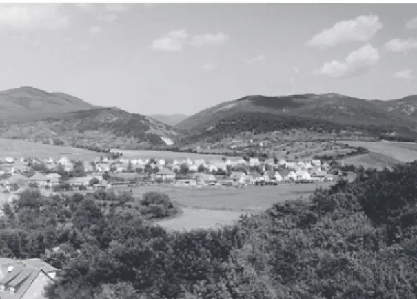
The Southern Foothill Area of the Bükk Mountains is situated in the North- ern Hungarian Mountains and is dissected by erosion valleys direction to the northwest and southeast. This is a pediment surface of the Bükk Mountains and its territory is 480 km2. This area is 4,37% of the macroregion of the Bükk Mountains and 26,7% of the mesoregion of the Southern Foothill Area of the Bükk Mountains. We can find the following settlements in this study area (Heves and Borsod-Abaúj-Zemplén County): Andornaktálya, Bogács, Bükk- zsérc, Cserépfalu, Cserépváralja, Demjén, Eger, Egerbakta, Egerszalók, Eger- szólát, Felnémet, Nagytálya, Noszvaj, Novaj, Ostoros, Szomolya and Tard (Ma- rosi S. – Somogyi S. 1990).
1
2 3 4 7
8
14
5
6
17 11 13
10 9
15 16
12
Tárkány basin
0 10 km
Settlements: 1 – Andornaktálya, 2 – Bogács, 3 – Bükkzsérc, 4 – Cserépfalu, 5 – Cserépváralja, 6 – Demjén, 7 and 11 – Eger (Felnémet), 8 – Egerbakta, 9 – Egerszalók, 10 – Egerszólát, 12 – Nagytálya, 13 – Noszvaj, 14 – Novaj, 15 –
Ostoros, 16 – Szomolya, 17 – Tard.
Fig. 1. The topographical map of the study area (Somogyi S. – Marosi S., 1990).
We could not found
landscape forms, which were categorized as protected geomorphological values
in this study area (Fig. 1.). Some landscape forms could be protected only as geological or cultural values here. We have mapped this territory in detail and we have found many interesting and beautiful geo- mophological forms, which are unknown by the local inhabitants and local gov- ernments. 10 or 15 meso or macro landforms could be indicated, which are spe- cial and characteristic landform types in the Souhern Foothill Area of the Bükk Mountains in case of each local settlement territory. These landforms provide a lot of information about the development of the pediment surface or its climatic conditions. According to our research work, we could supply that these unpro- tected and various geomorphological forms can integrated into the local settle- ment, tourism and landscape development plans. In this article, the most impor- tant and characteristic categories of the geomorphological values will be pre- sented.Geomorphological values’ categories in the Southern Foothill Area in the Bükk Mountains
1. The most important values’ categories in the study area:
1. remnants of the older pediment surfaces (asymmetric questas);
2. remnants of the younger pediment surfaces;
3. erosional main valleys with Quaternary fluvial terraces (Pleistocene No. II. a. and No. II. b. fluvial terraces, and Holocene No. I. fluvial terraces);
4. canyons;
5. derasional valleys and dells;
6. mass movements (breakage, landslides, gelisolifluctional move- ments, etc.);
7. cryoplanational and periglacial forms;
8. micro and macroforms of the travertines;
9. wetlands, alluviums;
10. antropogenic forms, 11. „Hive stones”.
2. Research methods:
The geomorphological values of the foothill area had been mapped by de- tailed field work. The most important values’ categories had been registered and photographed. The climatic conditions, the age of landforms and their develop- ment conditions had been investigated too. In some case of settlements, we had investigated the quantitative rate of the protected, unprotected geomorphological values and landscape forms supplied for the protection.
Presentation of the geomorphological values’ categories 1. Remnants of the older and younger pediments
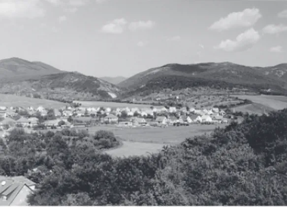
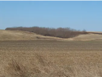
The most interesting macro landforms in the study area are remnants of the older and younger pediments. There was a large surface plannation (pedimenta- tion) in the southern rim of the Bükk Mountains during the Miocene and Plio- cene/Pleistocene (Pinczés 1968, 1970, 1980; Hevesi 1978, 1986, 1990; Pinczés- Martonné Erdős-Dobos 1993; Martonné Erdős 2000; Dobos 2001). The pedi- mentation was appeared in warm and dry climatic conditions, when sudden shower caused expressive areal erosion: (1) Miocene Ottnangien-Carpathien- Badenien period (20-14 Ma); (2) Miocene Sümegium and Bérbaltavárium period (8-5,5 Ma), and (3) at the boundary of Pliocene and Pleistocene in the Villany- ium period (2-1,8 Ma). According to the orogenic phases and valley deepening activities these pediments could be appeared as destroyed summits or remnants (Fig. 2-5.).
Fig. 2. Asymmetric older pediments (Karud and Mangó Hill) with younger, larger pediments
Fig. 3. Cserépfalu: cryopediments and cryoglacis in front of the Kút Hill and Perpác
Fig. 4. The Southern part of Nagy-Eged
Fig. 5. Eger: Tihamér – younger pediment with Pleistocene fluvial terraces
The remnants of the older plannated surface (Sümegium-Bérbaltavárium, 8- 5,5 Ma) can be found in 300-360 m above the see level. In some cases these land- forms are situated at the boundary between Southern Bükk Mts. and the Southern Foothill Area of the Bükk Mountains. Asymmetric questas can be seen in the Southern Foothill Area of the Bükk Mountains:
− Kút Hill (350 m), Perpác (341,2 m)
− Summits northwest of Bükkzsérc (330,8 m), Southern part of Nagy- Galya (330 m)
− Ravaszlyuk Hill (358,4 m)
− Nyomó Hill (340,2 m), Kecet Hill (350,2 m), Major-house (333,5 m), Nagy-Dobrák Hill (349,9 m)
− Mész Hill (367,8 – 353 m), Kőkötő Hill (318-309 m), Karud (371,2 m), Mangó Hill (305 m)
− Nyírjes (332,7 m), Barát peak (336,3 m)
− Dobogó peak (327 m).
The younger pediment surface is wider and more uniform. It was developed under the remnants of older pediments at 200-250 m above the see level (Fig 5.).
This surface has been developed under semiarid climatic conditions and after that it was planned, lowered and breaked up by the periglacial pedimentation under cooler climatic circumstances. The most characteristic peaks of this area are the following:
− Almagyar Hill (269,5 m)
− Pünkösd Hill (266,9 m), Kolompdugó peak (254,4 m)
− Kerek Hill (270,5 m), Hidegkút valley (250-270 m), Ortvány (285,6 m)
− Aranybika peak (265,8 m)
− Vilasmár (270 m), Égés peak (280 m)
− Őr Hill (271,8 m), Gyűr Hill (293,3 m)
− Berezd peak (273,9 m), Cseres wood (240-270 m), Sugaró Hill (222,6 m).
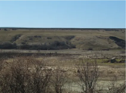
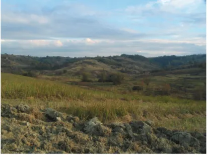
2. Erosional main valleys with Quaternary fluvial terraces (Pleistocene No. II. a. and II. b., or Holocene No. I. fluvial terrace)
The second typical landforms are main valleys trended from northwest to southeast in the Southern Foothill Areas of the Bükk Mountains: valleys of Szólát stream, Laskó stream, Eger stream, Ostoros stream, Kánya stream, Hór stream and Lator stream. The ancient and periodic water races appeared here and took part in the planation processes of pediments. In the Pleistocene, these water races became larger streams and began to deep and cut their watersteads into the surface during different climatic and tectonic phases. Their valley slopes are steep and they have got 50-100-200 m wide alluviums developed by linear ero- sion processes in the Quaternary period (Fig. 6-7.). The slopes were cut by lots of narrow and new water cuts during the warmer and rainy weather in the Holo- cene period. Because of the alternating valley deepening processes Pleistocene fluvial terraces No. II. b. and II. a. and Holocene fluvial terraces No. I. had been appeared along valley slopes (Fig. 6-7.).
Fig. 6. Erosional main valley with water cuts at the southern boundary of Bogács
Fig. 7. Erosional valley head in Szomolya
Fig. 8. Erosional watershed in the southern part of Szomolya
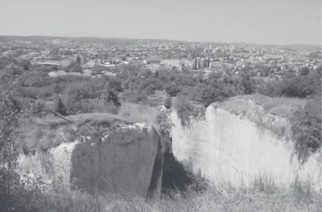
3. Canyons
In the studied settlements, deep and narow canyons can be found at the boundary between the Southern Bükk Mts. and the Southern Foothill Area of the Bükk Maountains. These fluvial forms were developed under special geological conditions, because Triassic limestone, Jurassic shale series and Oligocene Kis- cell Clays meet with Miocene rhyolite and dacite tuff layers along the Hór val- ley, Stone valley in Cserépváralja, and Upper valley in Cserépváralja. Similar
linear erosional canyons and parts of canyons can be seen along Miocene ignim- brites and non-welded rhyolite tuff layers in this foothill area for example in Cserépváralja valley south of Nyúl valley mouth and upper part of the Novaj stream. These valleys, canyons are generally epigenetic valleys. These areas were covered by different sediment layers where valley downcutting began and this water races, streams appeared first. Water races began to deep their water- stead into the surface and because of different tectonic and climatic phases these waterstead were transmitted into the hard stones and rock masses lying under the cover sediments. The welded rhyolite tuff layers, ignimbrites and limestones had come in sight and had begun to destroy. Karst landforms, karts springs, micro- karst forms had been developed on the limestone layers and rock walls. Cryo- planation towers, walls, debris or smaller tributary valleys based on the rhyolite and dacite tuff layers or ignimbrites had been appeared along the deeper canyons and valley’s slopes.
4. Derasional valleys and dells
The wide or narrow tributary valleys, which look like a dish form are dera- sional valleys and dells in the hilly regions in Hungary. They were formed under the cooler periglacial climatic conditions in the Pleistocene. The deeper soil and sediment layers were frozen and the upper parts of the soils and sediments (ac- tive layer) could freeze and thaw per day. The mass movements, gelisolifluction processes and areal erosion were taken part in forming this special landforms.
Pleistocene slope clays covered the deeper valley slopes and summits, that is why the mass movements, landslides, solifluction processes and soil degradation were typical here. These forms can be seen along the larger erosional valleys’
slopes everywhere in the foothill area (Fig. 9-10.).
Fig. 9. Bogács: Derasional valley
Fig. 10. Derasional valleys and dells in the western part of Eger
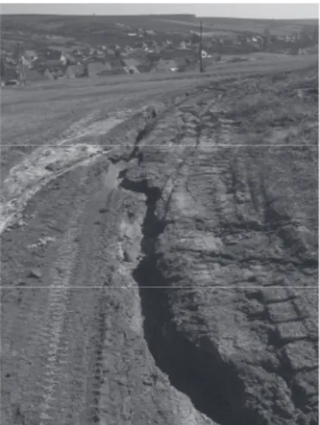
5. Mass movements (landslides, falls of ground, solifluction processes, etc.)
Interesting and various landforms are the different types of mass move- ments in the study area. We can find stepped, slided sediment layers along slopes, which were moved downwards by landslides, solifluctional processes or gelisolifluction (Fig. 10-12.). Talus cones and angular shaped debris can be seen in front of the rock walls, cryoplanation steps and towers. They were developed by fall of ground. Mass movements were appeared on special geological funda- mentals here. Pleistocene slope clays, Oligocene clays and sands or weathered Miocene rhyolite and dacite tuffs cover the slopes. These surface layers can ab- sorb the water easily during the warmer, wet climatic period and slide on the dry and harder sediment layers, which were deposited in the deeper soil and sedi- ment layers. These processes can produce quick landslides (Fig. 11.) or slower movements (some cm movements per year). The special type of the mass movements is the gelisolifluction. It was developed under the cooler, periglacial climatic conditions in the Pleistocene. The soil was frozen in the deeper sedi- ment layers (0,5-1-2 m deep layers), but the upper layers (active layers) can re- ceive the water because these layers thawed per a day. That is why the sediments in the upper parts could slide here and created new, various microlandforms on the slopes (Székely 1992). Some territory characterized by mass movement ac- tivities are under the agricultural production nowadays. The loosening of the soil, soil milling and spade-work can cause intensive soil degradation and soil devastation here (Fig. 12.).
Fig 11. Water-basin and landslides in Egerszólát
Fig. 12. Landslides in Bogács
6. Cryoplanation and periglacial landforms
Cryoplanational debris and talus cones could be mapped in front of the cryoplanation walls, towers and cryoplanation steps at the edge of plannated surfaces and valley slopes (Nyomó Hill, Kőkötő Hill, Karud, Pipis, Szaduszka peak, Felső valley, Cseres peak, Szomolya Király-széke /King’s chair/, etc.).
These landforms had been developed by frost activity. The shape of the debris is angular, poligonal and its size is about 10-20 cm in diameter depending on geo- logical conditions. Larger, gentle sloped landforms are cryoplanation pediments and glacis at the boundary of the Southern Bükk Mts. and The Southern Foothill Area of Bükk Mts. (Cserépfalu, Nagy-Eged, Egerszólát és Egerszalók, Fig. 13.).
These forms are formed by intensive frost weathering, cryoturbation and cryopedimentation during the Pleistocene period.
Fig. 12. Cryoplanational debris in the Nagy-Eged
Fig. 13. Cryopediment and glacis in front of the Kút Hill and Perpác
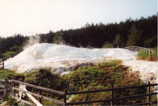
7. Travertine mound, micro and macro landforms in the travertine concretion
We can see smaller travertine mounds in some places in the study area. The travertine had got separated from the meteoric water on the surface of debris or different geological outcrops. They could conservate some places of ancient springs. Larger and well-known forms are in Eger (the western side of tower of the Castle) and in Egerszalók. Petroleum drill (No. De-42.) was deepened into the lower part of the Maklányi valley in 1961, where 8 000 000 m3 water flow to the surface and about 1000 m3 limestone was deposited in Egerszalók. The terri- tory of this mound is 2500 m2. The temperature of the water is 67 °C, the com-
position of this karst water is natrium, sulphur and CaMg(CO3)2 (Vasi et al.
2002). We can investigate small, some cm sized stepped, microkarst landfroms, meanders and travertine tetaratas here (Fig. 14.). Beautiful white rock layers can be seen where the continuous water cover has been guaranteed. In some places, the surface of the travertine layers are grey. These layers have begun to erode by insolation weathering, deflation, areal watersheds, frost activity and antropo- genic processes. The surrounding area of this travertine mound was rebuilt in the last few years because of the building operations of wellnes and tourist centrum.
The sight planning is the most important building activity here now, that is why the wider and new travertine mounds and slopes will be created. The area of the original travertine mound is under the environmental protection.
Fig. 14a. Egerszalók: travertine mound, prtotected landform
Fig. 14b. Egerszalók: Travertine’s microforms
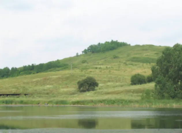
8. Wetlands, swampy area, alluviums
The alluvium of main erosional valleys are generally under the agricultural activity. We can find valuable alluviums, wetlands and swampy areas in some places only in the Southern Foothill Area of the Bükk Mountain. These areas consist of the protected territory called NATURA 2000. Interesting, romantic and valuable swampy areas are along the Rét valley (Ostoros stream), in the southern part of Noszvaj (south of Hosszú-Szél field, Fig. 15.-16.); and in front of the Szék valley. Fine fluvial sediments (sand, silt, clay) were deposited here in the Holocene period. These layers can keep the water for a long time, because the clay is a permeable rock type. We can find smaller opened water surface in some place among valuable and rich swampy vegetation.
Fig. 15. Noszvaj Holocene moor
Fig. 16. Noszvaj Holocene alluvium
9. Antropogenic forms (mines)
Our research area is built up with Miocene volcanic rocks, welded and non welded tuff series as Gyulakeszi Rhyolite Tuffs, Tar Dacite Tuffs, and Felnémet Rhyolite Tuffs. Pleistocene slope clays, loess, and loess like sediments cover the surface of these rhyolite and dacite tuffs. Because of the fluvial erosion, alluvi- ums is built up with Holocene fluvial sediments (clay, silt, sands, gravel) (Pe- likán 2002). New rock outcrops have appeared along the valley’s slopes and the extraction by mining explore these rock layers. Numerous open mines are inac- tive in the foothill area today. We need to solve the recultivation programmes of mines and their environmental management (Berva valley, Mész valley, Dem- jén, Egerszalók, Noszvaj, Cserépfalu, Cserépváralja, Egerszólát, etc.). More outcrop mines were taken place under the environmental protection, or new geo- logical trails were created along the cross sections and mining discrict in the last few years.
10. “Hive stones”
“Hive stones” are known as cultural landscape elements in the foothill area, which are under the local protection. Their natural development fundamentals had been investigated by Martonné Katalin Erdős (1972, 2000), Balázs Borsos (1991) and Csaba Baráz (2005). These tower shaped “hive stones” could be cre- ated by complex natural processes in the Quaternary period. They have got a lot’s of various meso and micro landforms (Fig. 17–20.). In the Pleistocene and Holocene period, main erosional valleys cut their waterstead into the surface and the deeper sediment layers were rised into the surface. The frost weathering, mass movements, areal slope wash and linear erosional activities formed these sediment layers under the different climatic effects. We can observe the influ- ence of the retrogressive erosion of the tributary valleys in case of forming rhyo- lite tuff cone and tuff comb. The bioerosional activities are intensive today on the rock surface.
Fig 17. Cserépfalu: Hive stone
Fig. 18. Cserépfalu: Erosional valleys and meanders in the Hive stone
Fig. 19. Cserépfalu: Devil Tower
Fig 20. Cserépváralja: Furgál valley
Summary
We can advise the most characteristic landforms inside the presented geo- morphological values’ categories for the protection in the Southern Foothill Ar- eas of the Bükk Mountain. We suggest these values to present in the field too.
Some settlements had begun to integrate these mapped geomorpholgical values into the development plans of the local authority and created new tourism cen- tres, trails and wellnes complexum for example in Cserépfalu, Cserépváralja, Noszvaj, Egerszalók and Felsőtárkány. We suggest geomorphological values, which are possessed prominent interests to integrate into the geological or geo- morphological trails because their protection and management can be control better for the future.
References
Baráz Cs. (2005): A bükkaljai kaptárkövek felszínalaktani vizsgálata és a kaptárfülkék korának meghatározása, in: Dobos A. – Ilyés Z. (szerk.): Földtani és felszínalak- tani értékek védelme, EKF Földrajz Tanszék – EKF Környezettudományi Tan- szék, Eger, pp. 203–215.
Dobos A. (2001): Az átmeneti (puffer) zóna geológiai értékvédelemben játszott szerepé- nek bemutatása egy bükkaljai mintaterület alapján. („A földrajz eredményei az új
évezred küszöbén”, A magyar Földrajzi Konferencia tudományos eredményei), SZTE TTK Természeti Földrajzi tanszék, Szeged, pp. 1–17.
Hevesi A. (1978): A Bükk szerkezet és felszínfejlődésének vázlata. Földrajzi Értesítő XXVII. pp. 169–198.
Hevesi A. (1986): A Bükk hegység felszínfejlődése és karsztja. Kandidátusi Értekezés, Budapest.
Hevesi A. (1990): A Bükk szerkezet- és felszínfejlődése, különös tekintettel a karsztoso- dásra. MFT 43. Vándorgyűlése, Miskolc, pp. 1–67.
Marosi S. – Somogyi S. (1990): Magyarország kistájainak katasztere II. – Bükkvidék, MTA Földrajztudományi Kutató Intézet, Budapest, pp. 837–868.
Martonné Erdős K. (1972): Az Alsó-Bükk kaptárkövei Studium III. A KLTE Tudomá- nyos Diákköre kiadványai, Debrecen, pp. 109–126.
Martonné Erdős K. (2000): A Bükkvidék, Kézirat, DE, Debrecen.
Pelikán P. (szerk.) (2002): A Bükk hegység földtani térképe (1: 100 000), MÁFI, Buda- pest.
Pinczés Z. (1968): A Bükk hegység tönk és pediment felszínei. MTA Földrajztudományi Kutató Intézet, Természetföldrajzi Dokumentáció, 7. pp. 32–39.
Pinczés Z. – Martonné Erdős K. – Dobos A. (1993): Eltérések és hasonlóságok a hegy- lábfelszínek plisztocén felszínfejlődésében, Földrajzi Közlemények CXVII. (XLI) 3. pp. 149–162.
Pinczés Z. (1970): Planated surfaces and pediments of the Bükk Mountains, Studies in Hungarian Geography 8. Problems of Relief Planation, Budapest, pp. 55–63.
Pinczés Z. (1980): Production of planation surfaces and their types as illustrated on the examples of a Tertiary volcanic and of a Mesozoic mountain. Acta Geographina Debrecina 1975-1976. XIV-XV. pp. 5–29.
Székely A. (1992): A periglaciális felszínformálás, in: Borsy Z. (szerk.): Általános ter- mészeti földrajz, Nemzeti Tankönyvkiadó, Budapest, pp. 356–420.
Vasi I. et al. (2002): Az egerszalóki termálkutak hasznosítása. Előzetes Környezeti Ha- tástanulmány, PRO TERRA Urbanisztikai Ügynökség, Budapest, 89. p.