XXIst EUROPEAN COLLOQUIUM
4 - 13 . 0 9 . 1989
HUNGARY
X X I - E - M - C
GUIDEBOOK H U N G A R Y ’ 89
Itinerary sketch, N
The Colloquium will be organised by the Hungarian Geological Society
Hungarian Central Office of Geology Hungarian Academy of Sciences l. Eötvös University, Budapest Hungarian Natural History Museum
with the sponsoring of the
International Palaeontological Association Ministry for Environment and Water Management Hungarian Geological Institute
Hungarian Hydrocarbon Institute National Centre of Museums •
Hungarian National Oil and Gas Trust Bauxite Exploration Enterprise Veszprém Coal Mining Enterprise Lowlands Petroleum Exploration Co.
Cartographia - Hungarian Company Surveying and Mapping Hungarovin - House of F-ine Wine
Honorary Committee:
Prof. T. BALDI, Department of Geology, L. Eötvös University, Budapest I. BÉRCZI, Deputy Director, Hungarian Hydrocarbon Institute Prof'. V. DANK, President, Central Office of Geology
Prof. J. FÍJLÖP, Rector, l. Eötvös University, Budapest Prof. G. HÁMOR, President, Hungarian Geological Society;
Director, Hungarian Geological Institute
I. MATSKÁSI, Director General, Hungarian Natural History Museum, Budapest
Prof. E. NEMECZ, President, Department of Geosciences and Mining of the Hungarian Academy of Sciences
Organizing Committee:
Chairman: T. KECSKEMÉTI, Deputy Director General, Hungarian Natural History Museum, Budapest
Secretary: A. NAGYMAROSY, Department of Geology, L. Eötvös University, Budapest
Members: M. BÁLDI-BEKE, Hungarian Geological Institute A. 8ÉRCZI-MAKK, Hungarian Hydrocarbon Institute F. GGCZÁN, Hungarian Geological Institute 0. HALMAI, Hungarian Geological Institute
M. HORVATH, Department of Geology, L. Eötvös University, Budapest
S. KOVÁCS, Hungarian Academy of Sciences
M. MONOSTORI, Department of Palaeontology, L. Eötvös . University, Budapest
A. ORAVECZ-SCHEFFER Hungarian Geological Institute
XXIst EUROPEAN
MICROPALAEONTOLOGICAL i i i i i i m XXI ■ E-M-C 4-13.09. 1989
HUNGARY
GUIDEBOOK HUNGARY- ’ 89
AUTHORS Mária BÁLDI-BEKE GI
Anikó BÉRCZI-KAKK Hl Erika BODNÁR GI Ilona BODROGI GI Tamás BUDAI GI Géza CSÁSZÁR GI Gábor CSILLAG GI Lajos DOSZTÁLY GI Endre DUDICH UNESCO László FÉLEGYHÁZI AC Ilona FRIDEL-MATYÚK GI Ferenc GÓCZÁN GI Ágnes GÖRÖG EU Dános HAAS CG Lilla HABLY NM Márta HADÓS GI Mária HORVÁTH EU
Katalin HORVÁTH-KOLLÁNYI GI Miklós KÁZ1ÉR EU
Tibor KECSKEMÉTI NM
Gábor KOPEK László KORDOS GI Sándor KOVÁCS AC Endre KROLOPP GI Katalin LENNER GI György LESS GI Miklós MONOSTORI EU Pál MÜLLER GI István Z. NAGY NM Elvira NAGY-BODOR GI András NAGYMAROSY EU Anna ORAVECZ-SCHEFFER GI Pál PELIKÁN GI
Csaba PÉRÓ EU Olga PIROS GI
Ágnes SIEGL-FARKAS* GI Andrea SZUROMI-KORECZ GI Edit TARDI-FILÁCZ AC Péter VARGA EU Attila VÖRÖS NM
GI = Hungarian Geological Institute, HI = Hungarian Hydrocarbon Institute, EU = L. Eötvös University. Budapest, NM = Hungarian Natural History Museum
Riirlapest, AC = Hungarian Academy nf Sciences, CG = Central- Office of Geology
Manuscript read by
Mária BÁLDI-BEKE, Tibor KECSKEMÉTI, András NAGYMAROST and Aana ORAVECZ-SCHEFFER
Translated by
írpád KISS and Katalin TAKÁCS-BÍRÓ Translation revised by
András GALÁCZ Scientific Editor
Tibor KECSKEMÉTI Technical Editor
Ilona-RÉMI
A
Published by the Hungarian Geological Society
Budapest,
CONTENTS
Address to the Participants of the XXIst European Micropalaeonto-
logical Colloquium (E. DUDICH)... 9
MEGATECTONIC SETTING AND STRUCTURAL UNITS OF HUNGARY (J. HAAS)... 11
VISITED REGION Geoloqy of North Hungary Paleozoic and Mesozoic terraines (S. KOVÁCS)... 15
Cenozoic formations of North Hungary (A. NAGYMAROSY)... 37
Geology of the Transdanubian Central Range Paleozoic and Mesozoic formations (J. HAAS)... 49
Cenozoic formations (T. KECSKEMÉTI)... 57
EXCURSIONS 5 Sept. A: BUDAPEST— SZURDOKPÜSPÖKI— RECSK— EGER... 69
Fót+... 69
Gödöllő... 70
A-l: SZURDOKPÜSPÖKI, diatomite quarry... 70
Gyöngyöspata... 77
Gyöngyös... 77
A-2: RECSK, Daliapuszta... 7H Sirok... 04
Eger... 04
6 Sent. B: EGER— NflSZVAJ— NDVAJ— RAKACASZFND— JÚSVAF6— AGGTELEK... 0-1: EGER, Wind's Brickyard... 07
B-2: NOSZVAJ, Kiseged, road cut... 101
B-3: NOVAD, Nyárjas Hill... 114
Bélapátfalva... 124
Szilvásvárad... 124
Edelény... 124
Szendrő... . ... 124
Szalonna... 125 +Cultural-historical notes
B-4: RAKACASZEND, road cut... 125
Rakacaszend... 128
B-5: JÓSVAFŰ, Vöröstó branch-off... 129
Jósvafő... 133
B-6: Facultative excursion to the BARADLA CAVE... 133
Aggtelek... 140
7 Sept. C: AGGTELEK— NEKÉZ5ENY— NAGYVISNYÚ— RÁKÓCZI TELEP (BLIKKZSÉRC, SZOKOLYA)— 5ÁM50NHÁZA— SALGÓTARJÁN... 141
C-l: AGGTELEK, Daradia plateau... 141
C-2: NEKÉZSENY, Strázsa Hill... 144
C-3: NAGYVISNYÚ, Mihalovits quarry... 149
Rákóczitelep... 156
C-4: BÜKKZ5ÉRC, Patkó cliff quarry (packed samples)... 156
C-5: SZ0K0LYA (packed samples)... 160
C-6: SÁMSONHÁZA, Várhegy... 165
C-7: SÁMSÜNHÁZA, Buda Hill... 169
Salgótarján... 175
B Sept. D: SALGÓTARJÁN— IPDLYTARNÓC— BUDAPEST: Pusztaszeri road, Mátyás Hill, Csillaghegy... 177
D-l: IP0LYTARNŰC, Nature Protection Area... 177
Szécsény... 183
Hollókő... 184
Pásztó... 184
D-2: BUDAPEST, Pusztaszeri road, road cut... 185
D-3: BUDAPEST, Mátyás Hill W... 194
D-4: BUDAPEST, Péterhegyi road, clay-pit... 199
9 Sept. E: BUDAPEST— TATA— TARDDSBÁNYA— ÓT0K0D— BUDAPEST... 207
Óbuda... 207
Tatabánya... 208
Vértesszőlős... 208
E—1: TATA, Kálvária Hill, Nature Conservation Area... 208
Tata... 220
E-2: TARDOSBÁNYA, Gorbabánya... 221
E-3: ÓT0K0D, Open pit mine, quarry of Kerék Hill... 226
Esztergom... 235 6
10 Sept. F: BUDAPEST— DUDAR— BAKONYNÁNA--ZIRC (OROSZLÁNYI-OLASZ
FALU— BALATONFÜREO... 237
Székesfehérvár... 237
Veszprém... 238
Zirc... 239
F-l: DUDAR, Ördögárok, valley head, forestry road... 240
F-2: BAKONYNÁNA, Zsidó Hill... 244
F-3: ZIRC, Cigányárok... 248
F-4: OROSZLÁNY (packed samples)... 251
F-5: OLASZFALU, Eperkés Hill... 252
Balatonfüred... 254
11 Sept. G: BALATQNFÜRED— SZÖC— PADRAGKÚT— MAGYARP0LÁNY— NYIRÁD— SÜMEG— BALATQNFÜRED... 255
G-l: SZÖC, Balaton Hill... 255
G-2: PADRAGKÚT... 262
Ajka... 274
G—3: MAGYARPOLÁNY... 275
G-4: NYIRÁD, Oarvastó... 283
G-5: SÜMEG, Mogyorós Hill... 290
Sümeg... 297
Badacsony... 297
Balaton-shore... 298
12 Sept. H: BALAT0NFÜRED--BALAT0NC5ICSÚ— PÉC5ELY— TIHANY— FELSÖÖRS— BUDAPEST... ,... 299
H-l: BALATONCSICSÖ, Csukrét Ravine... 299
H-2: PÉCSELY, Meggy-hegy quarry ... 310
H-3: TIHANY, Fehérpart... 316
Tihany... 325
H-4: FELSÖÖRS, Forrás Hill, Malomvölgy section... 326
Felsőörs... 336
COMPLETED REFERENCES... 337
ADDRESS
I0-IHE-PARilclPANls_OF_ib| XXIií^EÜBDglft^MICBDeéLAEONIOLOGICftL^CgLLOQÜiyM
I have the honour of conveying the best wishes of the International Geolonical Correlation Programme (IGCP) of Unesco and the International Union of Geological Sciences (IUGS) to the participants of this distinguished Colloquium.
Ever since its birth in 1972, the IGCP has been heavily involved, by definition and "ex officio", in stratigraphic correlation.
A remarkable variety of approaches and techniques of cor
relation have been applied by the various IGCP projects deal
ing with widely different geological formations of the Earth, ranging from eco- and chemostratigraphy through magnetnstra- tigraphy and seismostratigraphy to geomathematics. However, biostratigraphy has maintained its priority wherever applicable.
Within biostratigraphy, micropaleontology has been play
ing a prominent part, historically speaking ever since the pioneering works on Foraminifera of Miksa (Maximilian) HANTKEN.
In Hungary, HANTKEN's achievements were further developed by several other eminent micropaleontologists such as Pál ROZLDZSNIK and László MA.TZDN.
It is a particular pleasure for me that this Colloquium is hosted by Hungary -- my mother country.
I was initiated to Micropaleontology at the University of Budapest by L. MAJZON, and I had the privilege of working for five years at the Department of Paleontology (headed at that time by Professor László BDGSCH) in the field of- paleo-
bryozoology. This Department had M. HANTKEN as its first Professor. He was also the first Director of the Royal Hung
arian Geological Institute. This is now the Hungarian Geolog
ical Inst-itute where I had been serving before I was appointed Secretary of the IGCP in Paris.
I am convinced that Hungary will meet your expectations which can not be but high after so many successful Colloquia.
A wide variety of fossi 1 iferous formations, from the Carboni
ferous to the Pannonian in age, studied in the spirit of the well-established but constantly rejuvenating Hungarian school of micropaleontology, are at your disposal. The on-the-spot discussions and the subsequent comparative investigations will certainly refine some of the local and regional strati
graphic subdivisions, thus contributing, directly or indirect
ly, to international correlation, which is the main ohjective and "raison ri' etre" of the IGCP.
Last but not least: if proposal(s) of new IGCP projects take shape during your talks, they would be most welcome and given serious consideration by the Scientific Committee and the Board of the IGCP.
Appreciating and warmly acknowledging the efforts exerted by the organizers, and the professional interest of the par
ticipants shown by their attending the Colloquium, I wish you full success, to the benefit of the worldwide community of earth scientists.
Paris, 19 April 19B9 Endre DUDICH
Assoc. Prof.
IGCP Secretary Unesco SC/GED
10
M E _ G A JE_CJ_ONI_C__S_EJ_T_I_N_G__A N!_D_ S J RV[C_T_U R_A L _ U N I J_S_ O F . HLUNG A R Y
J. HAAS
Hungary lies in the central part of the Carpathian Basin surrounded by the Alps, the Carpathians and the Dinarides.
Three major geohistorical periods are reflected in Hungary's geology:
- a pre-Alpine evolutionary stage, difficult to reconstruct, connec
ted with Central Europe's Precambrian-Paleozoic history,
- the Alpine stage including the Late Paleozoic, Mesozoic and Paleo
gene evolution of the Tethys, with orogenic events (Eoalpine, Paleoalpine, Mesoalpine) manifested in napped-folded tectonics and large-scale strike- -slip movements,
- the Pannonian (Neoalpine) evolutionary stage lasting from the Early Miocene up to the present; a period characterised by formation of small pull-apart basins and then the Pannonian Basin by high-amplitude subsi
dence.
According to the development patterns of pre-Tertiary formations, the territory of Hungary can be divided into the following megatectonic units (Fig. 1).
1. Tisza Unit
To the south of the Mid-Hungarian Fault Zone the Tisza Unit can be outlined, including the Mecsek and Villány Mountains and their subsurface extension in the basement of the Great Hungarian Plain (Alföld) showing affinities with the Apuseni Mountains ( W Romania).
The high-grade polimetamorphic basement is covered by a Germano-type Permo-Triassic continental-shallow marine sequence. It is followed by Jurassic and Cretaceous series of different developments differences enabling the distinction of the Mecsek, Villány and Békés Subunits.
Mecsek Subunit is characterised mainly by thick Grestein-type Liassic, deep-water facies from the Upper Dogger and an intensive Lower Cretaceous submarine alkalic volcanism.
Fig. 1. Megatectonic units of Hungary
Villány Subunit has a Jurassic sequence with a great number of stra
tigraphic gaps, and Lower Cretaceous or Urgon facies— features showing si
milarities with the Bihor "autochtonous" unit in the Apuseni Mts.
Békés Subunit contains Upper Jurassic to Lower Cretaceous dark shales as in the case of the higher nappes of the Codru nappe system.
Upper Cretaceous formations of predominantly marine clastic deve
lopment lie on the older rocks with unconformity. Paleogene is known only in the subsurface part of the Mecsek Subunit (Szolnok Flysch Zone).
2. Pelso Unit
Situated between the Rába-Diósjenő Lines and the Mid-Hungarian Fault Zone, Pelso Unit is characterised by very low-grade and low-grade meta- morphic marine Early Paleozoic formations, and continental and marine Late Paleozoic sequences of South Alpine affinity. In the Mesozoic passi
ve continental margin formations are characteristic, but in certain sub
units remnants of the oceanic basement are known too.
Development indicates Alpine-Dinaric relationship.
Large-scale intermedier volcanism in the Eocene is an important fea
ture of the unit, what is unknown from the Tisza Unit.
The Pelso Unit can be devided into the following subunits:
Transdanubian Central Range Subunit can be characterised by terres
trial-marine Upper Permian, slow transgression from the Lower Triassic, intrashelf rifting in the Middle Triassic, thick peritidal carbonate sequence in the Upper Triassic, intrashelf rifting with general trend of deepening in the Jurassic, trans-regressive cycles in the Middle and the Upper Cretaceous and in the Eocene.
Mid-Transdanuhian Subunit is known only from boreholes. Most impor
tant features are the marine Upper Permian and the shallow carbonate platform formations in the Middle and Upper Triassic.
Bükk Subunit is constituted by Late Paleozoic marine sequence from which the Lower Triassic evolved with no break in sedimentation, follo
wed by a Middle and Upper Triassic of carbonate platform facies and vol- canites, and by Jurassic formation of schistes lustres type deposited in deeper-water slope and basin, as well as basaltic volcanites.
Aggtelek-Rudabánya Subunit the upper nappe includes Triassic of car
bonate platform facies and deeper water Jurassic showing North Alpine af
finity. The deeper nappes are composed of Middle and Upper Triassic of slightly metamorphosed deep-water facies and a Jurassic of schistes lustres character similar to its counterpart in the Bükk Mts.
3. Inner West-Carpathian Units
North to the Diósjenö Line crystalline complex of the Vepor Unit extends into the country's territory. It is known only from deep-borings.
A. Austro-Alpine Units
Penninic Unit: Jurassic to Lower Cretaceous metamorphites of green- schist facies in the Hungarian part of the Rechnitz Window (Kőszeg Mts.
and its subsurface extension in the basement of the Little Hungarian Plain /Kisalföld/).
Lower Austro-Alpine Unit: Paleozoic mesometamorphic formations known from the Sopron Mts.
Upper Austro-Alpine Unit: very low to low-grade metamorphites known from the basin substratum between the Repce and Rába rivers, representing an extension of the Graz Paleozoic series.
In terms of the present-day interpretation, the above mentioned mega- tectonic units approached each other only in the Early Tertiary, by si
zable plate tectonic reorganization processes that initiated probably in the Cretaceous.
In the Pannonian (Neoalpine) phase of evolution extension of the earth-crust and thinning of the lithosphere were the most important mega- tectonic phenomena.
Most intensive extension took place in the Middle Miocene when local pull-apart basins were formed together with volcanism in several phases.
In Late Miocene to Pliocene times accelerated subsidence of the Great and Little Hungarian Plains created the most characteristic present-day morphological features of Hungary.
14
yjsjifOfgjöB GEJ10G_Y_OF NORTH. HUNJ5AR.Y
PALEOZOIC AND MESOZOIC TERRAINE5 S. KOVÁCS
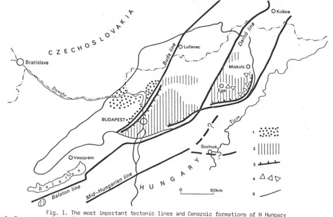
The Paleozoic and Mesozoic terraines in Northern Hungary (Fig. 1) form part of the Gemer— Bükk Units, which, in turn, have become part of the Pelso Superunit during the Paleogene major strike-slip faulting ac
tivity. They show definite Dinaric affinites, only the northernmost units (Gemer Paleozoic, Silice Nappe) are related to the southernmost North Alpine units (Northern Greywacke Zone and Hallstatt Mesozoic). It is now widely acknowledged by Hungarian geologists, that it means original paleo- geographical proximity to those units, from which position the Gemer—
Bükk Units have been "expelled" in front of the ENE-ward escaping "Ba
kony— Drauzug unit" during the Paleogene (KÁZMÉR— KOVÁCS 1985; BALLA in press), in consequence of the Mesoalpine tectogenesis, thus representing one of the displaced terranes of the Pannonian domain.
The Gemer— Bükk Units are bordered from the S by the Mid-Hungarian Fault Zone, while from the N by the Lubenik— Margecany Line. On the E they are separated from the Zemplén Unit (which has also been displaced to its present-day position in front of the ENE-ward escaping "Bakony—
Drauzug unit" by Lower Miocene times, c.f. BALLA, in press) by the Hernád Line. The boundary towards the W against the Transdanubian Central Range Subunit (=eastern part of the "Bakony— Drauzug Unit" in sense of KÁZMÉR—
KOVÁCS, 1985) is obscure, being hidden below the thick Miocene volcanic masses of the Mátra— Cserhát region.
The Gemer— Bükk Units comprise the following ones from the N to the S:
1. Gemer Unit, containing only Paleozoic rocks, with N-vergent struc
tures.
Fig. 1. Simplified geological map of the Gemer--Bükk units. (Compiled af
ter ÁRKAI— KOVÁCS 1986, GRILL et al. 1984, CSONTOS 1988, BAJANIK et al.
1984, ELECKO et al. 1985; as well as unpublished mapping by KOVÁCS, PELIKÁN and LESS).
1. Veporicum, 2. Gemericum (Paleozoic), 3— 8. Aggtelek— Rudabánya— Slovak Karst units: 3. Tornaicum, 4. Meliaticum, 5— 8. Silicikum: 5. Silice Nappe, 6. Szőlősardó Unit, 7. Bódva Nappe (a: Jurassic), 8. Komjáti Unit, 9— 18.
BLikkium: 9— 10. Uppony Paleozoic: 9. Uppony Unit (+Uppony-type Paleozoic in the Rudabánya Mts.), 10. Tapolcsány Unit, 11. Gosau-type Senonian conglome
rates in the Uppony Mts, 12— 13. Szendrő Paleozoic: 12. Rakaca Unit, 13.
Abod Unit, 14— 16. Fennsík (Tarkő) Parautochton of the bükk Mts.: 14. Upper Paleozoic, 15. Triassic, 16. Jurassic, 17. Szarvaskő— Mónosbél Nappe of the Bükk Mts., 18. Kisfennsik ("Little Plateau") Nappe of the bükk Mts., 19.
Tertiary and Quaternary, 20. nappe boundary, 21. major imbrications within nappes, 22. strike-slip fault
2. Aggtelek— Rudabánya and Slovak Karst Unit, with nappes built of different non-metamorphosed and metamorphosed Upper Permian— Mesozoic rocks. It is separated from the Gemer Unit by the Roznava Line. With the exception of the northernmost part, this unit is characterized by nappes gravitationally glided towards the S. The northernmost part is thrust upon the Gemer Unit, which carries even isolated "Deckschollen" of the nappes of this unit: they can be found up to the immediate proximity of the Lubenik— Margecany Line.
3. Bükk Unit, containing Paleozoic rocks of the Szendrő and Uppony Mts. and Late Paleozoic— Mesozoic rocks of the Bükk Mts. Most of its sub
units were effected by an anchi- to epizonal metamorphism. The Szendrő and Uppony Mts. are characterized by N-vergent overthrusts, while the Bükk Mts. by a S-vergent structure. The Aggtelek— Rudabánya and Bükk Units are separated by the Darnó Fault Zone, a Lower Miocene strike-slip zone.
Only the Hungarian part of the Gemer— Bükk Units will be described here in more details; the Gemer Unit and the Slovak karst are on the Czechoslovakian side and will not be touched by the present excursion.
Bükk Unit Szendrő Hills
The Paleozoic of the Szendrő Hills is built up by the sequences of the northerly Rakaca Subunit and the southerly Abod Subunit, the latter
18
being thrust upon the former. Mesozoic rocks are unknown. The sequences were effected by a greenschist-facies Alpine metamorphism (400 °C, 3 kbar;
ÁRKAI 1983); effects qf a Variscan metamorphism cannot be pointed out.
The §gqy@ne§ of the Abed Subenit (Fig, 2) begins with the Tapoicsány Formation (black, graphitic shales and siliceous shales, subordinateiy with fine-grained sandstone intercalations), most probably of Silurian age. The Szendrőlád Limestone Formation comprises bluish-grey limestones, both of biohermal and basinal facies, sandy limestones, as well as light-
Mq
Fig. 2. Lithostratigraphy of the Abod Subunit of the Szendrő Hills with the must important conodonts
-coloured phyllites and metasandstones. Its Middle Devonian (Eifelian—
Givetian) age is indicated by its rich coral fauna (MIHÁLY 1978) and co- nodonts (Polygnathus linguiformis etc. KOVÁCS in prep.x). It is overlain, on the one hand, by the Btikkhegy Marble Formation (pinkish— yellowish, thick bedded marbles of carbonate platform facies), most probably of Frasnian age. On the other, the metatuffitic Abod Limestone of basinal facies follows above it, with Frasnian and Famennian conodonts (Palmato- lepis glabra, Palmatolepis sp. and others).
The Rakaca Subunit is built up by two, characteristically light bluish-grey and white-banded marble formations of carbonate platform fa
cies, followed by a flysch-like detrital sequence (Fig. 3). The lower marble (Rakacaszend Marble Formation) contains pelagic intercalations and/or fissure fillings with Frasnian conodonts (Ancyrodella rotundiloba, Icriodus 5ymmetricus, Polygnathus pollocki etc). After a long gap, wit
nessed only by fissure fillings with Upper Frasnian— Lower Viséan mixed conodont associations, follows the Rakaca Marble Formation and the Szend- ro Phyllite Formation, interfingering with each other. The patch-reefs of the Rakaca Marble are encountered basinward by dark bluish-grey, origi
nally micritic limestones (Verebes-hegy Member) with conodonts from the Upper Viséan Gnathodus bilineatus bilineatus zone to the Lower Bashkirian Idiognathoides sinuatus zone. The lower part of the Szendro Phyllite For
mation contains olistostromes, olistothrymmas and allodapical limestones originating from the contemporaneous Rakaca Marble buildups, while sand
stone turbidites occur both in its lower and upper part (becoming rarer upward).
Uppony Hills
The Paleozoic of the Uppony Hills can also be subdivided into two subunits, namely the southerly, predominantly clastic Tapolcsány Subunit and the northerly, predominantly carbonatic Uppony Subunit. The contact between them is probably of strike-slip character, being the whole Uppony Hills within the Darno Fault Zone. The Paleozoic sequences were effected by an Alpine metamorphism falling to the boundary of the anchizone and epizone (350 °C and 2,5 kbar; ÁRKAI 1903).
x The conodont investigations have been carried out by the present author, therefore a separate reference will not be given at each conodont data.
20
Ma
. QGZHELI AN
IDKASIMOVIAN
-
CO u MOSCOWIAN
3 - O
X)
TJ BASHKIRIAN
cr Z ^ ... ... ■ " =____ S zen d ro II Idiognathoides sinuatus,
LU
■Ll
z - o
^ - i ^ x P h y l - R a k a ^ y ^ l i tc ca X 3 > Fm M a rb le > > v
Id .co rru g atu s,Id.nod.
S ERPUKHO- VI AN
noduli ferous Gnathodus bilineatus bollandensis Gn. bil. bilineatus P aragnathodus nodosus CD
CT
Fm <> £
<
o
£ o _J
VISEAN a, 'Ut
- 5 f l * _ ifl ° » u ■»- -o
Gnathodus delicatus Gn. p u n c ta tu s Siphonodella sp.
TOURNAISIAN
^ c (u a, o E £ 5 nFAMENNIAN > * t3 W) .ÜÍ
Palmatolepis sp.. A n c y- rodellasp., Icriodus symmetricus, Polygnathus pollocki
- z z>FRASNIAN ! 5 T U--- £ 1
<
- 21
i»
TJGIVETIAN o ÍZ•oE IFE L IAN
>
■ LU E M S IAN
o
o* SIEGENIAN
_j
GEDINNIAN
2 PRIDOLIAN
< LUDLOWIAN cr
3 WENLOCKIAN
_ j
CO LANDOVERIAN
>
o €>
n
ASHGILLIAN ocr
o
Q.
3 CARAOOCIAN
Fig. 3. Lithostratigraphy of the Rakaca Subunit of the Szendrő Hills with the most important conodonts
1. Rakacaszend Marble Fm., 2. Abod Limestone Fm., 3. Verebeshegy Limestone Member
The oldest formations of the Tapolcsány Subunit (Fig. 4) are probab
ly the Rágyincsvölgy Quartz-sandstone Formation and the Csernelyvölgy Sandstone Formation (feldspathic greywacke), which, on the basis of East Alpine analogies (SCHÖNLAUB 1979 and EBNER, p.c.) are placed into the Upper Ordovician. The Tapolcsány Formation contains grey to black shales and siliceous shales, and black lidites, with some basic volcanics. On the basis of the above-mentioned analogies (it corresponds to the Bischof- alm Facies of the Carnic Alps; c.f. SCHÖNLAUB 1979) it is most probably of Silurian age, but it may reach up into the Devonian, as well. The late Lower Devonian— Middle Devonian Strázsahegy Formation contains Schalstein- -type basic volcanics and olistostrome(s) with basic volcanic matrix and Silurian to lowermost Devonian limestone olistoliths, which are rich in conodonts (see the description of the Strázsahegy locality— C-3). It can
not be excluded, that the Strázsahegy Formation thrust upon the Tapolcsány Formation, constitutes an independent, third tectonic unit. The Éleskó Formation is composed of limestone olistoliths embedded in a sandy— shaly matrix. In the limestone olistoliths Emsian to Famennian conodonts have been found (from Polygnathus serotinus to Palmatolepis glabra), so the formation is younger, probably a Middle Carboniferous olistostrome. The southern part of the Tapolcsány Formation is overlain by Upper Cretaceous (Senonian) conglomerates with pebbles from the underlying Paleozoic and from the Triassic and Uppermost Jurassic of the Bódva Nappe of Rudabánya Mts., thus forming an upper boundary for the age of the metamorphism.
The sequence of the Uppony Subunit (Fig. 5) begins with the Middle Devonian Uppony Limestone Formation of carbonate platform facies, follo
wed by the metatuffitic Abod Limestone Formation with basic metavolcanic bodies. The latter contains Frasnian to Famennian conodonts (Ancyrodella nodosa, Palmatolepis gracilis gracilis and many other species). The Lower Carboniferous is represented by a fairly thin flaser limestone sequence (Dedevár Limestone Formation) with Siphonodella cooperi, Gnathodus deli
catus and others. The time-equivalent of the flysch-type Szendro Phylli- te is here the Lázbérc Formation, which, on the contrary is built up by normal alternation of dark bluish-grey limestones and dark-grey shales, without signs of resedimentation. It contains the same Upper Viséan—
Lower Bashkirian conodonts. The youngest formation (calcareous sandstone with small quartz and lydite pebbles, sandy limestone) probably corres
ponds to the Mályinka Formation of the Bükk Mts.
22
Ma
©
300-cn - OD
crLű - LL
■ O 2
CD
‘<cr cj
350-
2 O
>
' LU Q
400-
<
cr3
450-
>
O Q
cr -
o '
GZJHEUA Ü.
KASIM OVI AN M0SC 0W IAN BASHKIRIAN
S E R P U K H 0 - VIAN
V IS E A N
T0URNAISIAN FAMENNIAN FRASNIAN GIV ETIAN EIFELIA N EMSIAN SIEGENIAN GEDINNIAN P RID0LIAN LUDL0WIAN WENL0CKIAN LANDOVERIAN ASHGf LLIAN CARADOCI AN
Palmatolepis delicatula, P minuta, Ancyrodella sp., Icriodus alternatus, Polygnathus linguiformis, Polygnathus costatus, Polygnathus serotinus
Spathognathodus aff.optimiE Sp.masarus, Sp. wurmi, Sp. remsch. remscheidensis, Sp inel.inclinatus Spinel, inflatus, Kockeleilavariabilis, Sp. sagittus_______________
Fig. 4. Lithostratigraphy of the Tapolcsány Subunit of Uppony Hills with the most important conodonts
1. Continuous line indicates biostratigraphically proven age
Ma
300 -
©
350-
V if)i T) 3 ■D O zcr LU Li_
Z o l—
GO €J CC *
< o
400-
450
GZHELIAN KASIMOVIAN
SERPUKHO■
VÍAN VISE AN
* FAMENNIAN
^ F R A S N I A N GIVET1AN EIFEL IA N EM SIA N SIEGENIAN GEDINNIAN PRIDOLIAN LUDLOWIAN
MOSCOWIAN
Malyinka (?) Far matton____
BASHKIRIAN
La zb ere Formation
TOURNAISÍAN
Dedevar Limestone
Fm.
Abod Limestone
Fm
■ ;1; 5
Uppony Limestone Fhn
WENLOCKIAN LANDOVERIAN _ ASHGILLIAN
CARADOCIAN
Idiognafhoides sinuatus, Id. nod. nod üli f erous, Id. la teralis
Paragnatho - dus nodosus Gnathodus _______
bilineatus b ilineatus Gnathodus bilineatus bollandcnsis
Gnathodus delicatus/
Gnathodus pseudo- semiglaber
Siphonodella sp., S. cooperi, Polygnathus inornatus, P communis,
Pseudopolygnathus sp.
Bispathodus costatus, B. ziegleri,
Palmatolepis gracilis gracilis, Palmatolepis sp., R glabra lepta, leriodus symmetricus, Polygnathus xylus xylus, P webbi
Fig. 5. Lithostratigraphy of the Uppony Hills with the most important conodonts
1. Continuous line indicates biostratigraphically proven age
24
Bükk Mts.
According to the latest subdivision (CSONTOS 1988), the Bükk Mts. is built up by the following subunits: the Fennsík "Autochton" (including the North Bükk and Fennsík anticlines), the Szarvaskő— Mónosbél Nappe and the Kisfennsik Nappe. The latter two are non-metamorphosed, while the me- tamorphic degree of the North Bükk anticline changes from the diagenetic zone to the epizone (towards the E); the rest of the Fennsík "Autochton"
is anchizonal metamorphosed, reaching in some parts the epizone (350 °C and 3 kbar average; ÁRKAI 1983).
The sequence of the Fennsík "Autochton" (Fig. 6) begins with a Bash- kirian— Lower Moscovian flyschoid sequence (Szilvásvárad Formation). It is followed by the Upper Moscovian— Gzhelian (probably reaching even in the Asselian; c.f. KOZUR 1985) shallow-water carbonatic— clastic sequence of the Mályinka Formation, very rich in fossils (calcareous algae, fusu- linids, corals, bivalves, brachiopods etc). These two formations corres
pond to the Hochwipfel flysch and Auernig Group of the Carnic Alps (c.f.
SCHÖNLAUB 1979). After a hiatus a thin limestone breccia horizon follows, probably corresponding to the Tarvis Breccia of the Carnic Alps (PELIKÁN, p.c.) ovaiain by the Middle Permian evaporite-bearing Szentlélek Formation.
Besides evaporites, sandstones prevail in its lower part and its sequence becomes more and more dolomitic upwards. In fact, this formation repre
sents the beginning of the Alpine sedimentary cycle here. The Paleozoic is terminated by the Upper Permian Nagyvisnyó Limestone Formation ("Bellerophon Kaik"): black, algal limestones with dolomites and thin intercalations of black shales.
The Nagyvisnyó Limestone is overlain by light-coloured oolitic lime
stones (Gerennavár Limestone Formation). The position of the Permian—
Triassic boundary is still the matter of discussion; according to KOZUR 19B5, it would be above the lithological boundary. The rest of the Lower Triassic is made up by a shallow-water clastic— carbonatic sequence in
"Werfen Facies" (Ablakoskővölgy Formation). During the Middle and Upper Triassic, the sedimentation took place in an outer shelf environment, with carbonate platforms (Hámor Dolomite, Fehérkő Limestone, Fennsík Limestone) and intraplatform basins (grey, cherty limestones of the Hollóstető and Felsőtárkány Formation). The carbonate sedimentation is interrupted by two thick (up to 200--300 m) volcanic horizons: in the Lo-
wer Ladinian by the Szentistvánhegy Porphyrite and in the Carnian by the Óhuta Diabase. In the Middle Carnian a clastic event can be recognized (marly slates and lime schists of the Vesszős Formation). The carbonate platform environment was disrupted near to the Triassic— Jurassic bounda
ry, the deepening of the sedimentary basin below the CCD is documented by variegated basinal limestones (pink, red and grey, often crinoidal or cherty), finally by red, resp. brown and green radiolarites. The sequence is terminated by dark shales with some turbiditic sandstones and black radiolarites and radiolarian shales. The latters, according to KOZUR 1985, contain Bajocian radiolarians (Unuma echinata Zone).
Lökvölgy Slate with black radiolarites
R g d , b ro w n an d green r a d io ! .
Répáshuta Limestone
Vesszos Fm Fehér
kö Limestone Limestone.
Szentistvánhegy Porphyrite Sebesvi'z Congl.—
Hámor Dolomite Ablakoskóvölgy Fm Gerennavar Limestone Nagyvisnyo Limestone 26
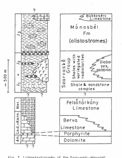
The Szarvaskő— Mónosbél Nappe contains a lower ophiolitic suite (Szarvaskő Group) with sheeted dyke and pillow lava complexes and associa
ted sedimentary rocks (dark shales, sandstones), and a higher olistostro- mal sequence, the Mónosbél Formation (olistostromes with shaly matrix, limestone olistoliths, allodapical limestones) (Fig. 7). Triassic rocks (mostly grey, basinal limestones with some conodonts) are only known frcm olistoliths. The age of the basic rocks, according to radiometric deter
minations, is Liassic— Dogger (165^, resp. 168^8 Ma for the age of the gabbroic intrusion; ÁRVA— SÓS et al. 1987), while that of the Mónosbél Formation is Upper Jurassic, as shown by foraminifers from allodapical limestones (Protopeneroplis striata; BÉRCZI--MAKK and PELIKÁN 1984).
The Kisfennsik Nappe contains non-metamorphosed, white, thick-bedded to massive limestones with some megalodonts (showing to a probable Upper Triassic age) and porphyrites.
Aggtelek— Rudabánya Unit
The excursion route will touch only the Flungarian part, i.e. the territory of the Aggtelek Karst and Rudabánya Mts.
The most part of the region is built up by the nappes of the non- -metamorphosed Silicicum (Silice Nappe in the Aggtelek and Slovak Karst, Bódva Nappe in the Rudabánya Mts.). The underlying metamorphosed units, belonging to the Meliaticum and Tornaicum occur only in tectonic windows or are known only from boreholes.
The sequence of the tectofacies units/subunits building up this region (Fig.O)begins with Upper Permian evaporites (Perkupa Evaporite Formation).
The upper part of the evaporitic— lagoonal sequence is tectonically non disturbed and gradually passing into the Lower Triassic marine formations, while its lower part is chaotically (mélange-like) folded, containing obducted slivers of a later-generated oceanic crust (=the Tornakápolna facies of the Meliaticum) ripped up during the southward gliding of the Silicicum.
There is no significant difference in the sequences of the units prior the Middle Triassic rifting, which started in Middle Anisian times.
In the Lower Triassic the site of sedimentation gradually shifted from a near-shore setting with elastics (Bódvaszilas Sandstone Formation) to an
offshore setting with restricted lagoonal conditions (the vermicular Szinpetri Limestone Formation). The initial stage of the Middle Triassic building up of carbonate platforms was represented by deposition of the euxinic lagoonal Gutenstein Limestone and Dolomite Formation. In late
oo in
Bük kz sere Li mestone
Mo n o s b e l Fm
(olistostromes)
=0
jC VI Q.=3 Í-5'C
S h a le 4 sandstone complex
Felsotarkany L i mestone Berva
Limestone Porphyrite Dolomite
28
Fig. 7. Lithostratigraphy of the Szarvaskő— Mónosbél Nappe of Bükk Mts.
(PELIKÁN, CSONTOS, KOVÁCS)
Lower and early Middle Anisian times the whole region (with the exception of the Bódvarákó facies) was an open shelf carbonate platform, with dasycladaceans and foraminifers (Steinalm Limestone and Dolomite Forma
tion).
The facies differentiation started with the disruption of the uni
form Steinalm carbonate platform. As the rifting proceeded, the following tectofacies units came into existence, which persisted throughout the Triassic (see Fig. 9).
A/ Silicicum
1. Drnava facies; Carbonate platforms until the latest Norian, lo
cally interrupted with intrashelf basinal facies at,the Anisian/Ladinian boundary interval. It builds up the northern part of the Silice Nappe and is restricted to the Slovakian territory only.
2. Aggtelek facies: Carbonate platforms (Wetterstein Formation)until the early Late Carnian, with south-facing reefs. This shelf margin domain subsided in the Late Carnian and after a transitional facies (Silická Brezová Limestone) typical Flallstatt limestones deposited from the begin
ning of the Norian, followed by Zlambach marls in the latest Norian and Rhaetian. It builds up the southern part of the Silice Nappe.
3. Szólősardó facies: Slope facies, with frequent redepositional phenomena (see BALOGH and KOVÁCS 1981). It is considered to build up a southern, frontal scale of the Silice Nappe.
4. Bódva facies: Predominantly red-coloured, deep water, strongly condensed carbonatic formations (Bódvalenke Limestone, Hallstatt Lime
stone), passing into siliceous sediments deposited below the CCD (Szár- hegy Radiolarite Formation). Conspicuous facies variations, various hia
tuses and certain redepositional phenomena are witnesses of uneven bottom topography. It builds up the non-metamorphosed unit of the Rudabánya Mts.
(the Bódva Nappe).
5. Bódvarákó facies: The Steinalm Formation is missing and dark-grey to black Gutenstein dolomites are followed immediately by the similarly dark-coloured Bódvarákó Formation of restricted basin facies (strongly cherty limestones with dolomitic marls and siltstones in its lower part).
SILICI CU M (H u n g a ria n par t) ( non - m e ta m o rp h )
PERM. I A A A P e r k u p a E v a p o r i t e A A
Figs. 8a-b. Triassic formations of the Aggtelek Karst and Rudabánya Hills (KOVÁCS et al. 1980)
30
Legend: 1. Carbonate platform facies, 2. pelagic basinal facies, 3.basinal detrital facies (marly-argillaceous). 4. radiolarite, 5. ophiolite, 6.
shallow marine detrital and marly facies, 7. restricted lagoonal carbona
te facies, 8. evaporite
Fig. 9. Triassic palinspastic section across the West Carpathian and the Dinaric-type North Hungarian iso- pic zones, from the Tatricum to the Bükkium (KOVÁCS 1986, unpubl.)
1. Continental crust, 2. oceanic crust, 3. unconsolidated pre-Alpine basement, 4. Upper Permian limestone 5. Upper Permian evaporite, 6. Werfen facies (marine Scythian), 7. "Buntsandstein" facies (continental Scythian), 8. Gutenstein Fm. (initial carbonate platform facies), 9. Middle Triassic carbonate platform facies, 11. Triassic radiolarite, 12. Triassic volcanics (non-ophiolitic), 13. Carnian coarse detrital fa
cies, 14. Carnian fine detrital facies, 13. Upper Triassic carbonate platform facies, 16. Upper Triassic basinal facies, 17. Carpathian Keuper
Whether its original setting was to the S or to the N of the rift axis, ancf belongs to the Silicicum or to the Meliaticum, it is still a matter of debates.
B/ Meliaticum
6. Drzkovce facies: Deposited on thin continental crust: Anisian platform carbonates are followed by Ladinian red radiolarites (the type locality at Meliata also belongs here). This facies occurs only in the Slovakian side.
7. Tornakápolna facies (after the borehole Tornakápolna 3; see RÉTI 1983): Deposited on oceanic crust, Ladinian red radiolarites immediately overlie pillow lavas (resp. intercalate them). Those of the Darno Mt. and its surrounding (Stop Daliapuszta— A-2) also belong here.
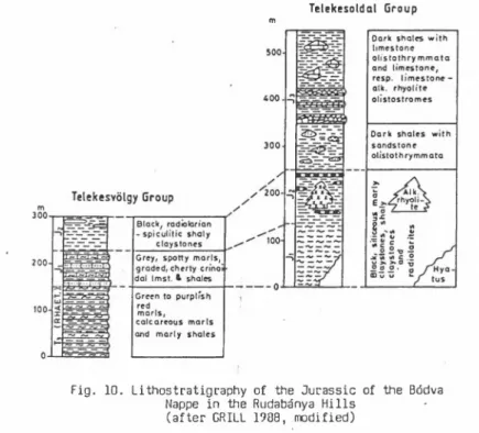
Telekesoldat Group
m
Fig. 10. Lithostratigraphy of the Jurassic of the Bódva Nappe in the Rudabánya Hills
(after GRILL 1988, modified)
C/ Tornaicum
8. Torna facies: Predominantly grey basinal carbonatic formations, practically lacking redepositional phenomena. Anchi- to epizonal metamorp- hosed (250 ^C, 7 kbar; ÁRKAI— KOVÁCS 1986). It builds up the metamorphic unit of the Rudabánya Mts. (Toma Nappe).
Jurassic rocks in the Hungarian territory are known only in the Bód- va Nappe (Fig. 10): dark-grey to black shales and radiolarian shales, si
liceous marls and sometimes black radiolarites, furthermore spotty marls ("Fleckenmergel"), alkaline rhyolites. Olistostromes, similarly to that of the Bükk Mts., represent likely the uppermost part of the sequence.
Biostratigraphic data are known only from the radiolarian shales and radiolarites: a rich radiolarian fauna belonging to the Bajocian Unuma echinata zone (GRILL and KOZUR 1986).
Cretaceous rocks are unknown here.
References
ÁRKAI, P. 1983: Very low- and low-grade Alpine regional metamorphism of the Paleozoic and Mesozoic formations of the Bükkium, NE-Hungary. — Acta Geol. Hung. 26 (1): 83-101.
ÁRKAI, P.— KOVÁCS, S. 1986: Diagenesis and metamorphism of the Mesozoic of the Aggtelek— Rudabánya Mountains. — Acta Geol. Hung. 29 (3-4):
349-373.
ÁRVÁNÉ SÓS E.— BALOGH K. — RAVASZNÉ BARANYAI L.— RAVASZ CS. 1987: Mezozóos magmás kőzetek K/Ar kora Magyarország egyes területein. (K/Ar dates of Mesozoic igneous rocks in some areas of Hungary.) — Földt. Int.
Évi Jel. 1985: 295-307.
BAJANÍK, S. et al. 1984: Geological map of the Slovenské Rudohorie Mts.
1:50 000. — GÚDS Bratislava.
BALLA, Z. (in press): Oligocene— Neogene kinematics of the Carpatho-Pan- nonian region and its bearing on Tethyan reconstructions. -- In:
IGCP Project 198 Final Volume.
BALOGH K.— KOVÁCS S. 1981: A Szőlősardó 1. sz. fúrás. (The Triassic sequ
ence of the borehole Szőlősardó 1. N Hungary.) — Földt. Int. Évi Jel. 1979: 39-63.
34
BÉRCZINÉ MAKK A.— PELIKÁN P. 1984: Jura képződmények a Bükk hegységből.
(Jurassic formations from the Bükk Mountains.) — Földt. Int. Évi Jel.
1982: 137-166.
CSONTOS, L. 1988: Étude géologique d'unes portion des Carpathes interness:
la massif du Bükk (NE de la Hongrie). (Stratigraphie, structures, mé- tamorphisme et géodynamique). — Thése de doctorat Univ. Sci. Techn.
Lille Flandres-Artois 250: 327 p. Lille.
ELECKO, M. et al. 1985: Geologická mapa Rimavskej kotliny. 1:50 000. — GÚDS Bratislava.
GRILL J. 1988: A Rudabányai-hegység jura formációi. (Jurassic formations of the Rudabánya Mountains.) -- Földt. Int. Évi Jel. 1986: 69-103.
GRILL J.— KOVÁCS S.— LESS GY.— RÉTI ZS.— RÓTH L.— SZENTPÉTERY I. 1984: Az Aggtelek-Rudabányai-hegység földtani települése és fejlődéstörténete.
(Geological constitution and history of evolution of the Aggtelek— ’ Rudabánya Range.) — Földt. Kút. 27 (4): 49-56.
GRILL, J.— K0ZUR, H. 1986: The first evidence of the Unuma echinatus radi- olarian zone in the Rudabánya Mts., NE Hungary. — Geol. Palaont.
Mitt. Innsbruck 13 (11): 239-275.
KÁZMÉR, M.— KOVÁCS, S. 1985: Permian— Paleogene paleogeography along the eastern part of the Insubric— Periadriatic Lineament System: Evidence for continental escape of the Bakony— Drauzug Unit. — Acta Geol.
Hung. 28 (1-2): 71-84.
KÁZMÉR, M.— KOVÁCS, S. 1989: Triassic and Jurassic oceanic/paraoceanic belts in the Carpathian— Pannonian region and its surrounding. In:
SENGÖR, A. M. C. (Ed.): Tectonic evolution of the Tethyan System. — p. 77-92. Kluwer Acad. Press, Doodrecht.
KOVÁCS, S. 1984: North Hungarian Triassic facies types: A rewiew. — Acta Geol. Hung. 27 (3-4): 251-264.
KOVÁCS S.— LESS GY.— PIROS 0.— RÓTH L. 1980: Az Aggtelek— Rudabányai hegy
ség triász formációi. (Triassic formations of the Aggtelek— Rudabá
nya Mountains.) — Földt. Int. Évi Jel. 1986: 19-43.
KOVÁCS, S.--PÉRÓ, CS. 1903: Report on stratigraphic investigations in the Bükkium (Northern Hungary). — In: SASSI, F.— SZEDERKÉNYI, T. (Eds.):
IGCP Project 5 Newsletter 5: 58-65. Padova/Budapest.
K0ZUR, H. 1904: New radiolarian taxa from the Triassic and Jurassic. — Geol. Palaont. Mitt. Innsbruck 13 (2): 49-88.
KOZUR, H. 1985: Biostratigraphic evaluation of the Upper Paleozoic cono- donts, ostracods and holothurian sclerites of the Bükk Mts. Part II:
Upper Paleozoic ostracods. — Acta Geol. Hung. 28 (3-4): 225-256.
MIHÁLY S. ,1978: A Szendrői-hegység középsődevon Tabulatái. (Die mittelde- vonischen Tabulaten des Szendroer Gebirges.) — Geol. Hung. Ser.
Geol. 18: 115-192.
PELIKÁN P. 1985: A terület földtani ismeretessége. In: NAGY E. et al.: A Bükk hegység és környezete komplex földtani előkutatási programja.
(Only Hung.) — p. 9-24. Földt. Int. (Manuscript.)
RÉTI, ZS. 1985: Triassic ophiolite fragments in an evaporitic melange, Northern Hungary. — Ofioliti, 10 (2/3): 411-422. Bologna.
SCHÖNLAUB, H. P. 1979: Das Paleozoikum in Österreich. — Abh. Geol. B.-A.
33: 124. Wien.
36
CENOZOIC FORMATIONS OF NORTH HUNGARY A. NAGYMAROSY
1. Introduction
Cenozoic events played an important role in the geological history and structural evolution of N Hungary. This part of the country obtained its final shape at a rather late period, i.e. after the Miocene,when the great amplitude processes of sedimentation, volcanism and tectonics had already been completed.
In the geological history of almost all N Hungarian regions the Cenozoic period had played an important role. Both the thick Tertiary sequences of the Cserhát Mts., those of the Salgótarján basin, Ozd-Borsod basin, and footland areas of the Mátra and Bükk Mts. were deposited that time and the volcanic masses of the Börzsöny Mts., Cserhát Mts., Mátra Mts. and Zemplén Mts. emerged at that period. Even Palaeozoic-Mesozoic mountains, like the Bükk, Aggtelek Karst, or the Rudabánya Mts. had under
gone important structural changes during the Neogene.
Contrary to former ideas stating that N Hungary's tectonic structure and basic geographical outlines, in a draft form, were already present by the end of the Mesozoic, today it is supposed that even during the Oligocene and Miocene still important lateral dislocations of several 10 km order of magnitude took place and as a result, compressive zones might have been formed, e.g. at the feets of the Mátra of Bükk Mts. The most important tectonic lines, active still in the Tertiary, are the following:
the Buda Line, starting from the Buda Mts. across the W Cserhát Mts; the Darno Line, crossing the E Mátra Mts. and separating the zones of the Bükk and Rudabánya Mts.; the Hernád Line, bordering the Zemplén Mts. from the W and also the so-called Balaton Line, as structural boundary of N Hungary from the south (Fig. 1).
Since most of the Tertiary formations developed in the area of the former Paratethys, in its stratigraphy the regional stage-system of the
Fig. 1. The most important tectonic lines and Cenozoic formations of N Hungary
1. Occurrence of the Hárshegy Sandstone, 2. occurrence of the Tard Clay, 3. southern and western borders of the Tard Clay, 4. olistostromes and turbidites in the Tard and Kiscell Clay, 5. occurrence of Oligocene
rocks (epicontinental type)
Central Paratethys will be used. In order to introduce a special stage- -system for the Paratethys, it is required to be ascertained that the Pa-
Me o
STANDARD STAGES
CENTRAL-PARATETHYS REGIONAL STAGES - O
UJZ oUJ
Piacenzian o
_lCL Zanclian 5
M essin ian Pontian
o-
Tortonian
Pannonian S. Str.
UJ z UJ o o
Serravallian
Sarm atian
Badenian
Langhian
— Karpathian
- Burdigalian Ottnangian
n - Eggenburgian
J
-
Aquitanian
Egerian 3 ‘
UJ z
Chattian
) - UJ o C3
o Rupelian Kiscellian
) -
UJz
LUO Priabonian Priabonian
oUJ
Fig. 2. The regional stages of the Central Paratethys
ratethys, separating from the Mediterranean, had a differring, indepen
dent and unanimous bioprovince and sedimentation history. In BÁLDI's (1986) opinion, the first endemic event influencing the whole Paratethys took place in the Early Oligocene, soon after the Eocene— Oligocene boun
dary, that is why a stage system starting with the Oligocene, differring from the world-scale is used (Fig. 2).
Stratotypes of some regional stages can be found in Hungary's terri
tory. Such are the Kiscellian in Budapest on the Kiscell Plateau (its final definition is still to be worked out), and the Egerian in the town Eger, at the SW margin of the Bükk Mts.
2. Paleogene 2.1. Eocene Formations (Fig. 3)
No Paleocene formations are known from N Hungary. The Eocene trans
gression reached this region only by the very end of the Priabonian. Se
diments of the Upper Eocene sea can be traced only in the W Cserhát Mts., in the N foreland of the Mátra Mts. and in the footland areas of the Bükk Mts.
Fig. 3. The Eocene formations of N Hungary (after DUDICH, p.c.)
40
The corallinacean, sometimes nummulitic, biogenic Szépvölgy Limestone is deposited unconformly upon the older formations with a thickness of hardly 50 m. From this the pelagic, epibathyal Buda Marl develops that reaches even the 200 m thickness toward the S. The allodapic limestones and calcareous turbiditic benches intercalated in the Buda Marl refer to the steep morphology of the slope between the shoreline and the deep ba
sins. In the upper, more pelitic section of the Buda Marl the carbonate content gradually decreases, and this member is ranged already in the Oli- gocene.
The Recsk region (N Mátra Mts.) is characterized by important ande
sitic volcanic-subvolcanic activity in the Priabonian. Volcanism is accompanied also by ore formation that led to the formation of Hungary's largest copper ore deposit.
2.2. Dligocene formations (Fig. 4)
From the Buda Marl spanning through the Eocene/Oligocene boundary the Tard Clay develops continuously that can be traced from the Buda Mts. till the Bükk Mts. The sediment accumulation area of the Tard Clay covers the S-SE section of N Hungary.
The lower member of the Tard Clay consists of greyish clayey marl and marl and shows lamination increasing upwards. This phenomenon is due to increasing anoxia, that is to the lack of bioturbation. In the upper part of the member faunas gradually become extinct, that beside the anoxia refer also to the changing salinity.
At the boundary of the upper and lower members, layers characterized by the endemic Cardium lipoldi and endemic nannoflora were deposited.
The upper member of the Tard Clay is a markedly microlaminated, darkish grey, black shaly clay, often rich in fossil fishes. Other faunal elements, due to anoxia and changing salinty of the surface waters, are rather rare. The pebbly— sandy fluxoturbidites within this member of the Tard Clay, found in the foothill region of the Bükk Mts. were transported by submarine slumps. The euxinic nature of the Tard Clay indicates a partial isolation of the Middle Paratethys from the world oceans.
At the boundary of the Lower and Upper Kiscellian substages the connection with the world oceans has been restored. Due to the- extremely
rapid subsidence of the N Hungarian sedimentary basin an extremely thick sedimentary sequence was deposited, i.e. the Kiscell Clay reaching even an 800 m thickness developed during 2--3 million years. The Kiscellian sea far extended that of the former Paleogene sedimentary basins. Its shore
line can be traced as far as the Buda and Gerecse Mts. to the W and Lu- cenec (S Slovakia) to the N. Along this coastline the Hárshegy sandstone, the heteropic coastal facies of the Kiscell Clay was deposited. The pela
gic features of this basin are increasing toward S-SE. However, this part of the shoreline is not known, because here the basin is bordered by tectonic zones.
Fig. A. The Oligocene formations of N Hungary 42
At the bottom of the well-oxigenated basin of the Kiscell Clay rich benthic Foraminifera existed, a fauna consisting of more than 200 species.
No such diversity among the fossils from the water column could be traced.
At the beginning of the Egerian the subsidence got slower and the basin became shallower. The shoreline of the Egerian sea overlapped that of the Kiscellian towards N and W. This was the time when, in N Hungary, the Eger and Kovacov Formations, and the Szécsény Schlier were deposited.
All these three formations develop by continuous sedimentation from the Kiscell Clay.
The Kovacov Formation is 300— 400 m thick, consisting of alternating sandy and pelitic sediments. In its marine upper part the brackish-water and fresh-water intercalations become more frequent. The formation is most wide-spread in the W Cserhát Mts.
The Szécsény Schlier was formed int the E Cserhát Mts., Salgótarján basin and in the N and S foreland of the Mátra Mts. It is a pelitic for
mation reaching even a maximum thickness of 400— 500 m with frequent sandstone banks. Its depositional depth can be put to 100--200 m. The for
mation of the Szécsény Schlier was continuous across the 01igocene/Mio- cene boundary and, in the E Cserhát Mts. it passes over even the Egerian/
Eggenburgian boundary.
The Eger Formation occurs at the type area, in the foreland areas of the Bükk Mts. Upon the sublittoral, mollusc-rich clay a regressive sequ
ence consisting alternately of sandstone, silt and clay is deposited with brackish-water intercalations in its higher parts.
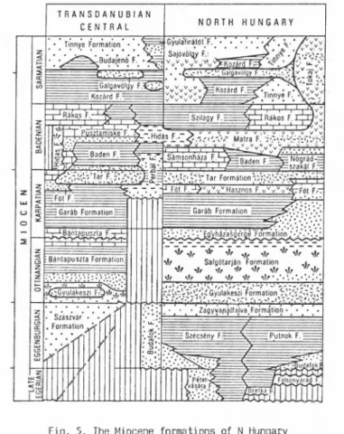
2.3. Miocene formations (Fig. 5)
At the end of the Egerian a general regression started that resulted in a temporary "lack" of sedimentation for the whole area concerned. Conti
nuous sedimentation can be found only in the zones enclosed by the Buda and Darnó Lines, i.e. in the Cserhát Mts., the Salgótarján basin and the N foreland of the Mátra Mts. The new, Eggenburgian transgression affected only a smaller area than that of the Egerian one. Its shoreline, indicated ty the Budafok Formation with large Pectens and Anomias can be traced from the Buda Mts., through the W Cserhát Mts. up to Slovakia. The forma
tion of the Szécsény Schlier continued in the E Cserhát Mts.., while in
the Salgótarján basin and in N Mátra Mts. the 200— 300 m thick glauconi
tic Pétervására Sandstone was deposited upon the Egerian part of the Szé- csény Schlier. The Pétervására Sandstone is the shallow marine but not coastal heteropic facies of the Szécsény Schlier.
In the N foreland of the Bükk Mts. the Putnok Schlier Formation transgresses an older, Palaeozoic-Mesozoic basement.
In the Ottnangian a general regression took place in N Hungary. This, after the deposition of the cycle-closing Zagyvapálfalva Formation with
44
Fig. 3. The Miocene formations of N Hungary (after HÁMOR and HALMAI, p.c.)
continental, terrigenous sediments led to the complete elevation and erosion of the region. (The famous Ipolytarnóc footprint sandstone also belongs to this formation).The formation of the Gyulakeszi Rhyolite Tuff (’’lower rhyolite tuff") can be also rangod in the earliest Ottnangian, and it is an important stratigraphic guide horizon for the whole terri
tory of Hungary. Based on thickness data, the epicentre of the eruption can be located N of the Mátra Mts.
While the pre-Lower Ottnangian facies and formations do not "tres
pass" the already mentioned megatectonic zones, from the end of the Ott
nangian these zones do not already coincide with paleogeographic bounda
ries. Thus it can be concluded that the large-scale lateral rearrange
ments had been completed by the end of the Ottnangian.
First product of the Ottnangian transgression is the Salgótarján Coal Formation of the Salgótarján and the Ozd-Borsod basins. Within the thick, terrigenous sequence in the Salgótarján region three, while in the Úzd region five coal-measure units can be found. Above the coal measures, by advancing of the transgression brackish-water Rzehakia (Oncophora) beds deposited first and later the Pecten-rich Egyházasgerge Formation. This latter contains fossils already from the Karpathian. The Garáb Schlier represents the climax of the Karpathian transgression.
This pelitic formation was deposited in the internal, deepest, deep-sub- littoral zone of the basin, while at the margins the calcareous, sandy, shallow-marine and coastal sediments of the Fót Formation were developed.
Generally speaking, the Karpathian basin could neither in extension, nor in depth, reach the size of the Paleogene basin.
The most important period of Tertiary volcanism in Hungary began at the boundary of the Karpathian and Badenian.
After the deposition of the Tar Dacite Tuff ("middle rhyolite tuff"), an extremely heterogeneous stratovolcanic complex, the Mátra Andesite Formation has formed. The elimination of the term "Formation" would be perhaps more advisable, since the term "Mátra Andesite" refers rather to a horizon with several sites of eruptions than to one continuous rock- -body. Main eruption centres were the Börzsöny and Mátra Mts. The 1500 m thick stratovolcanic complex of the Mátra foreland and the volcanic area of the Cserhát Mts. also belong to this volcanism. The contemporaneous formation of the Selmecbánya (Stiavnicky) and Ostrovsky Mts. can be due
to the same rhyolite to pyroxenic andesite volcanic event. Between the Lower Badenian volcanic horizons and upon the volcanic complex the Nógrád- szakál and Sámsonháza Formations of extremely heterogeneous petrographical composition were deposited. The first is a shallow-marine, coarse, detri- tal sediment coming from the denudation of volcanic rocks, while the other is a sand containing also volcanic debris, tuffitic marl and limestone (="lower Lcithakalk"). Due to the progressing Badenian transgression sandy sediments were deposited around the Börzsöny Mts. too, while in the N foreland of the Bükk Mts. marly sediments (Szilágy Formation) can be found.
The Badenian sea covered all the territory of N Hungary, except for its island-type volcanic mountains and the Bükk Mts. This period coinci
des with the beginning of the subsidence of the Pannonian Basin. The Lower and Middle Badenian sediments can be found mainly in the N, while the southern part of the territory is characterized by a full Badenian sedi
mentary sequence.
At the beginning of the Sarmatian Stage the (now final) isolation of the Paratethys from the world-oceans had started. At the coastline of the brackish Sarmatian sea the calcareous-sandy Tinnye Formation, while wit
hin the internal part of the basin the Kozárd Formation developed. The Gyulafirátót Rhyolite Tuff ("upper rhyolite tuff") level can be also found in the Sarmatian sediments. The enormous volcanic complex of the Zemplén Mts. was also formed in this period.
In the upper parts of the Miocene (Pannonian and Pontian Stages) N Hungary represented only the marginal zone of the large Pannonian la
custrine system. Thicker, pelitic-sandy sequences, could be deposited only at the S margin of the North Hungarian Range, including also endemic Pannonian-type mollusc assemblages. In the immediate neighbourhood of the mountains, thinner layers of variegated clays and redeposited volcanic debris represent the Upper Miocene rocks. In the S foreland of the Mátra and Bükk Mts., the widespread Bükkalja Lignite Formation is important.
The eruption of the Salgótarján basalt volcanoes can be put to the Plio- cene/Pleistocene boundary.
The Quaternary is rather an interval of erosion than sediment accu
mulation. This period is represented by thin loess, variegated clay and boulder sediments.
46
References
BÁLDI, T. 1984: The terminal Eocene and Early Oligocene events in Hungary and the separation of an anoxic, cold Paratethys. — Eel. Geol.
Helv. 77 (1): 1-27.
BÁLDI, T. 1986: Mid-Tertiary stratigraphy and paleogeographic evolution of Hungary. — Akadémiai Kiadó, Budapest, p. 201.