Borehole-wall scanning for Mars research – testing the ExoMars 2020 rover’s work at Tabernas Desert
Kereszturi A.1,6 Duvet L. 2, Gróf Gy. 3, Gyenis A. 3,4, Gyenis T. 3, Kovács B. 3, Maros Gy. 5
1Research Centre for Astronomy and Earth Sciences, Hungary; Email: kereszturi.akos@csfk.mta.hu; 2European Space Agency, ESTEC, The Netherlands; 3Budapest University of Technology and Economics, Hungary; 4Kolorprint LP. Hungary;
5Mining and Geological Survey of Hungary. 6Hungarian Astronomical Non-profit Ltd.
Abstract
Field work to support the preparation of ExoMars H2020 rover was realized in October of 2018 at the Tabernas Desert, Spain. The drilled holes in the field were scanned to provide information on the depositional environment and formation conditions.
Such a context for the drill acquired samples is useful for their correct interpretation on Mars. The main findings are presented in this work, including suggestions for future usage.
1. Introduction
The aim of this work is to compare the potential results of the optical scanning of borehole-wall during sampling. Here the target material is surveyed while still embedded in the original environment.
Future Mars missions will heavily exploit in-situ work for sample return and rely on material obtained from borehole, as biologically relevant target is expected to survive at meter depth. The benefits of this method at Mars analogue sites [1,2] were tested to support ExoMars 2020 rover, where MaMISS instrument [3] will do partly similar work in the infrared.
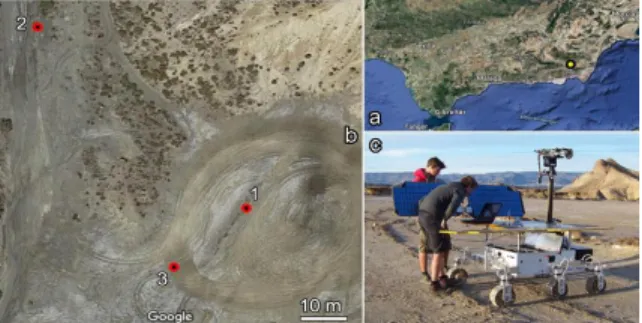
Figure 1. Location (a) and map (b) of the drilling sites with an example image of the rover (c).
The ExoMars 2020 rover will realize the first deep drill on Mars down to 2 m depth. To better understand what are the main characteristics of the
given depth where the acquired sample comes from, a borehole-wall scanner for field activity was developed in Hungary [4] what is able to scan the borehole-wall up to 0.1 mm spatial resolution, and was tested at various sedimentary and volcanic sites in Hungary, Morocco [5] and Chile in the Atacama Desert [6]. The field site of Tabernas Desert is located at 37.018N, -2.453E where the using ExoFiT rover was realized (Fig 1.). The region is composed of submarine deposited, occasionally by turbidite currents transported sandstone bodies, where the material was partly recently redeposited to form alluvium, transported by rain supported rare floods.
Occasionally salts as evaporates were also present.
2. Results
The compiled mosaics of the boreholes are indicated in Figure 2, 3 and 4. Some features are artefacts from the drilling process, while others are original ones.
Although the three drills were produced in resemble target they are different, but show same characteristics at the same with the occurrence of similar features at the same borehole (Figures 2-4).
Specific borehole-wall features observed at the 1.
drill site in Tabernas are visible on Figure 5.
Figure 2. Mosaic of the Tabernas 1 site.
Figure 3. Mosaic of the Tabernas 2 site.
EPSC Abstracts
Vol. 13, EPSC-DPS2019-385-1, 2019 EPSC-DPS Joint Meeting 2019
c Author(s) 2019. CC Attribution 4.0 license.
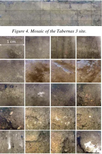
Figure 4. Mosaic of the Tabernas 3 site.
Figure 5. Magnified insets of interesting borehole- wall features (10x10 mm size).
Magnified insets in Figure 5 show examples for vertical cracks (line 1), voids left behind fallen out wall segments (line 2), different colored grains (line 3), different color grains and aggregates (line 4), cemented bright material and striped grain (line5).
Using the results gained at Tabernas, completed with other borehole scans done in Hungary, Chile and Morocco, three scenarios were compared on how much information could be gained from drilled subsurface samples: by optical scanning, by infrared scanning (will be done by MaMISS) and sampling without scanning methods only the measurements after the sample acquisition (see Table 1). These three methods could be considered as three end case scenarios: the optical analysis focuses on the materials embedded in their original context, while the no scanning case focuses only on the mineral characteristics of the acquired sample. The IR method shows some resemblance to both above listed cases. These optical methods are important for research on Mars and [7] planning next missions [8].
Table 1: Comparison of various characteristics (1.
column) of optical (2. column) and infrared (3. column) borehole-wall scanning, and the lack of borehole-wall data information only of the acquired sample (4. column)
(Values: 0 - no data, 1 - moderate, 2 - firm information)
characteristics opt. IR no
mineral type identification 0 2 2
existence of bulk ice 1 2 0
hydrated minerals 0 2 2
clay fraction 1 2 2
weathering products 1 2 2
original grain separation 2 1 0
grain size 2 1 1
grain orientation 2 1 0
presence of aggregations 1 0 0
cement between grains 2 1 1
transport mode identification 2 1 1
vertical trend 2 1 0
layering 2 1 0
erosion, desiccation surfaces 2 1 0 It is visible that while the optical analysis gives a range of constrains for the original depositional conditions, the other two methods are less useful for this aim, As a result future drilling attempts on Mars should take into account the optical borehole-wall analysis, as it provides such type of information what would give context for the interpretation and would be lost otherwise during sample acquisition.
3. Conclusions
New type of information would provide by optical borehole-wall scanning by optical methods to support context information. Further work is necessary to identify exactly what could the planned MaMISS detector identify among them, however the optical range gives new perspectives for future exploitation.
Acknowledgements
The Mars relevant activity was supported by the COOP_NN_116927, the site access and technology aspects by the EXODRILTECH of ESA, the software based image analysis by the GINOP-2.3.2-15-2016- 00003 project of NKFIH and the Hungarian Astronomical Non-profit Ltd. Further support from Schwenzer S. and Dobke B. is also acknowledged.
References
[1] Groemer et al. Acta Astron. 66:780–787, 2014; [2] Orgel et al.
EPSC2013-905, 2013; [3] De Sanctis et al. Astrobiology 17, 612-620, 2017;
[4] Kereszturi et al. Open Astronomy 28, 1-13, 2019; [5] Kereszturi et al.
Astrobiology 18, 1329-1350, 2018; [6] Kereszturi et al. EPSC2018-216, 2018. [7] Schwenzer & Kring Geology 37, 1091-1094, 2009; [8] Monchieri
& Dobke 12th Reinventing Space Conf., BIS-RS-2014-23