György Bárdossy, Andrea Mindszenty
The Iharkút bauxite Az iharkúti
bauxit-előfordulás
2013, Budapest, Hungary
The Iharkút bauxite
Az iharkúti
bauxit-eelõfordulás
Written by — Írta
G
Gyyö örrg gyy B B
ÁRDOSSY, Andrea M
INDSZENTYBudapest, 2013
Occasional Papers of the Geological and Geophysical Institute of Hungary,
volume 1
© Copyright Geological and Geophysical Institute of Hungary (Magyar Földtani és Geofizikai Intézet), 2013 All rights reserved! Minden jog fenntartva!
Serial editor — Sorozatszerkesztő GYULAMAROS
Technikal editor — Műszaki szerkesztő OLGAPIROS
DTP OLGAPIROS
Cover design — Borítóterv DEZSŐSIMONYI
Published by the Geological and Geophysical Institute of Hungary — Kiadja a Magyar Földtani és Geofizikai Intézet
Responsible editor — Felelős kiadó TAMÁSFANCSIK
director — igazgató
This book has been subsidized by the Committee on Publishing Scientific Books and Periodicals of Hungarian Academy of Sciences
A könyv a Magyar Tudományos Akadémia Könyv- és Folyóiratkiadó Bizottságának támogatásával készült
ISSN 2064–0293 ISBN 978-963-671-293-8
The Iharkút bauxite
Topographic description . . . . History of the discovery and prospecting of the Iharkút bauxite . . . . Stratigraphy . . . . Bedrock . . . . Bauxite . . . . Cover . . . . Late Cretaceous (primary) cover . . . . Eocene . . . . Oligocene . . . . Late Miocene (Pannonian) . . . . Quaternary . . . . Geomorphology . . . . Structural geology . . . . Depositional features of the bauxite . . . . Lithology of the bauxite deposit . . . . Micromorphology of the bauxite . . . . Areal distribution of microfacies . . . . Summary of the microfacies distribution . . . . Interpretation . . . . The basal clay . . . . Silt-size intercalations in oolithic bauxite . . . . Vertical stacking of lithofacies . . . . Chemical composition of the bauxitic sequence . . . . The main chemical components of the bauxite . . . . The Al2O3content . . . . The SiO2content . . . . The Fe2O3content . . . . The TiO2content . . . . Loss on ignition (L.O.I.) . . . . The interrelations between the chemical components . . . . The accessory chemical components of the bauxite sequence . . . . The CaO content . . . . The MgO content . . . . Sulphur content . . . . The MnO2content . . . . The organic C content . . . . The P2O5content . . . . Trace elements of the bauxite . . . . Mineralogy of the bauxite sequence . . . . Genetic interpretation . . . . Evaluation of the exploration and of the resource calculations . . . .
Contents — Tartalom
5 6 7 7 8 8 8 9 9 9 9 10 12 14 23 27 29 32 33 33 33 33 34 34 34 38 41 43 45 48 52 52 52 52 53 53 53 54 55 55 58
Suggestions regarding further explorations . . . . Summary . . . . Acknowledgements . . . . Az iharkúti bauxit-előfordulás
Topográfiai leírás . . . . A terület földtani megismerése és a korai bauxitkutatás története . . . . Kutatástörténet 1975–2005 . . . . Rétegtani helyzet . . . . Fekü . . . . Bauxitösszlet . . . . Fedőképződmények . . . . Csehbányai Formáció . . . . Ajkai Formáció (?) . . . . Jákói Márga Formáció . . . . Polányi Márga Formáció . . . . Eocén képződmények . . . . Oligocén (–alsó-miocén?) . . . . Pannóniai . . . . Negyedidőszaki képződmények . . . . Geomorfológia . . . . Szerkezeti viszonyok . . . . Az előfordulás teleptani jellemzői . . . . A telepek kőzettani felépítése . . . . A bauxit szövete, szerkezete . . . . A szöveti típusok térbeli eloszlása . . . . Függőleges szelvények . . . . Laterális elterjedés . . . . A szöveti jellegek értelmezése . . . . A bauxitösszlet fő és járulékos kémiai komponensei . . . . A fő kémiai komponensek . . . . Al2O3-tartalom . . . . SiO2-tartalom . . . . Fe2O3-tartalom . . . . TiO2-tartalom . . . . Izzítási veszteség . . . . A fő komponensek összefüggései . . . . A bauxitösszlet járulékos komponensei . . . . CaO-tartalom . . . . MgO-tartalom . . . . Kéntartalom . . . . Mangántartalom . . . . Szervesszén (Corg) tartalom . . . . P2O5-tartalom . . . . A bauxitösszlet nyomelemei . . . . A bauxitösszlet ásványos összetétele . . . . A bauxit-előfordulás genetikai értékelése . . . . A bauxitkutatás és a bauxitkészletek értékelése . . . . A további kutatások kilátásai . . . . Összefoglalás . . . . Köszönetnyilvánítás . . . . Epilógus . . . . References — Irodalom . . . . Enclosure — Melléklet . . . .
63 64 64
65 65 67 68 68 69 69 69 70 70 70 70 71 71 71 71 72 73 77 81 83 83 84 84 85 85 86 89 92 94 96 98 100 100 101 101 101 102 102 102 104 104 106 110 111 111 112 113 119
The bauxite deposits of Iharkút are situated on a slightly dissected low-hilly area. The hills are bordered by some deeply dissected valleys. Their elevation in the north-eastern part of the deposit is between 450 and 530 metres above the sea level. It diminishes in the southern part of the deposit to 490 to 420 metres and in the central part to 340 to 400 metres. It is 250 to 290 metres in the northern part of the occurrence. The hills become lower to the west of the deposit in the direction of Bakonyjákó village.
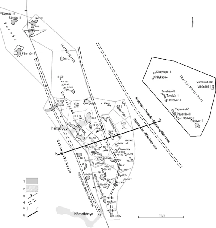
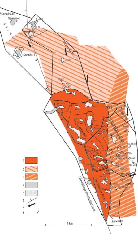
The area of the occurrence is elongated in north-northwest/south-southeast direction. Its length is 5.2 km and its width varies from 0.5 to 1.4 km. A smaller 2.1 km long and 0.4–0.5 km wide strip of bauxite bearing sinkholes was detected to the north-east of the main deposit at about 1 km distance. It is covered only by Quaternary sediments (Figure 1).
The bauxite deposits were named Iharkút in the north and Németbánya in the south according to the adminis- trative boundaries of Iharkút and Németbánya villages. The deposits were denoted by roman numbers in order of their discovery (Figure 2).
During the exploration phase the area of the occurrence was divided into
The Iharkút bauxite
Topographic description
Figure 1. Geological sketch map of Ihar- kút and the surrounding area (Post- Cretaceous formations not indicated) after CSÁSZÁRet al. 1978
Legend: 1 – Upper Cretaceous marls (Jákó- and Polány Formations), 2 – Upper Cretaceous alluvial siliciclastics (Csehbánya Fm), 3 – Upper Triassic dolostones (Main Dolomite Fm), 4 – Jurassic formations (limestone, chert, radiolarite), 5 – Mid Cretaceous (Albian) clay marls (Tés Fm), 6 – Mid Cretaceous (Aptian) limestone (Tata Fm), 7 – Lower Cretaceous limestone (Zirc Fm) 8 – selected boreholes 1. ábra. Az iharkúti bauxitelőfordulás föld- tani környezete, a késő-krétánál fiatalabb képződmények elhagyásával (CSÁSZÁR et al. 1978 nyomán)
Jelmagyarázat: 1 – felső-kréta tengeri képződ- mények (Jákói és Polányi Márga F), 2 – felső- kréta törmelékes üledékek (Csehbányai F.), 3 – triász dolomit (Fődolomit F.), 4 – jura képződ- mények (mészkő, tűzkő, radiolarit), 5 – közép- ső-kréta (albai) agyagmárga (Tési F.), 6 – középső-kréta (apti) mészkő (Tatai F.), 7 – alsó-kréta mészkő (Zirci Mészkő F.), 8 – mélyfúrások
four “mining-sectors”, called Iharkút–I, –II and Németbánya–I, –II concentrations. In the present monograph the entire prospected area was divided by us into seven sectors and their borders have been adjusted to the main geological fea- tures. A separate sector was distinguished on the western, downfaulted side of the occurrence, containing four bauxite deposits. A further bauxite sector was detected at the north-western, downfaulted part of the occurrence, called Sármás.
Finally, the above mentioned strip to the north-east of the main deposits is considered also a separate sector, containing four groups of bauxite-filled sinkholes called Királykapu, Tevelvár, Pápavár and Vörösföld
History of the discovery and prospecting of the Iharkút bauxite
The discovery of the Iharkút occurrence dates back to the early ’50-ies when Noszky J. jr (Hungarian Geological Institute), has completed his 1:25 000 scale concise geological map of the Northern Bakony which — on assignment by the Hungarian–Soviet Bauxite Aluminium Company — included also a systematic evaluation of the bauxite potential of the area (NOSZKY1951). Bauxite indications — mainly erosional remnants cropping out from below young (Neogene) Figure 2.Sketch-map of the Iharkút bauxite occurrence with the bauxite deposits and the exploration districs indicated
Legend: 1 – bauxite deposit, 2 – bauxite deposit exploited 3 – major fault-line, 4 – boundary of exploration-district
2. ábra.Az iharkúti bauxitelőfordulás hely- színrajzi vázlata a bauxittelepekkel és a kutatási részterületek határaival
Jelmagyarázat. 1 – bauxittelep, 2 – bauxittelep (kitermelt), 3 – fontosabb törésvonal, 4 – kutatási terület/részterület határa
sediments — were detected at several places. Noszky correctly realized that in addition to the already well known Early Albian bauxite horizon, the stratigraphic gap between the Late Triassic and the Late Cretaceous may also be promising.
The few samples he collected from the outcrops near Iharkút proved to be high-grade bauxites (Al2O3: 61.1%, SiO2: 1.30%) with abundant boehmite and gibbsite (identified with DTA). The bauxite potential of the Iharkút area was fur- ther confirmed in 1952 by four successful boreholes and it has been included in the register of potential resources of the Transdanubian Range ever since then. No large scale operations were launched there, however, until after the early ’70- ies. The reason for the apparent ignorance was that the Bakony Bauxite Mines had high grade resources of almost unlim- ited volume and in a gently rolling, almost flat terrain in the Southern Bakony (Halimba, Nyirád, Szõc), close to the Ajka alumina plant and with a long ago established infrastructure. So the mines were reluctant to shift to the remote, dissect- ed, hilly area of the Northern Bakony, where not only a new mine but also new transportation facilities should have been established. The situation has, however, changed in the early ’70ies. The majority of the bauxite resources of the Southern Bakony were situated below the karst water table and the detrimental effect of the underground mining oper- ations to the thermal water reservoir feeding the nearby world-famous spa (Hévíz) imposed severe problems on the min- ing company. The need for near-surface reserves exploitable with open-pit methods directed the attention to Iharkút, where potential resources were suspected close to the surface and well above the water table.
In 1973 high-grade bauxite unexpectedly exposed by a torrential rain in a ravine right at the outskirts of the village of Iharkút gave top priority to the area and the Exploration Company of Hungalu (the Hungarian Aluminium Corporation) immediately started with the drilling operations. Soon the first open-pit was opened and simultaneously detailed geologi- cal mapping of the adjoining areas aided by systematic geophysical ground-survey began (KNAUER1975, 1977; SZANTNER et al. 1978; KAKASet al. 1980). One after the other the peculiar deep sinkhole filling deposits were discovered along the major regional unconformity between the Late Triassic mainly dolomitic bedrock and the overlying Late Cretaceous silici- clastic sediments. As a result of several episodes of post-Cretaceous erosion some of the deposits were covered secondari- ly by a thin veneer of Quaternary sediments only. Due to the sharp contrast between the petrophysical characteristics of dolomite and the unconsolidated Quaternary coverbeds geoelectric survey carried out by the team of the Eötvös L.
Geophysical Institute (MÁELGI) proved to be very efficient in tracing the hidden palaeokarst surface underneath. This way the efficiency of the drilling operations could be greatly improved. Exploration on the deposits of the central part of the occurrence was completed by the end of the ’70-ies and exploration of the adjoining areas (Németbánya on the SE and Tüskés-tetõ, Sármás to the North) followed soon. Detailed exploration on the north-eastern margins began only in the ’90- ies. Because of its topographically elevated position, and the general lack of either Cretaceous or Eocene formations, this area was originally not considered promising, however, as a result of the geophysically aided drilling campaign, it turned out that the remnants of some high-grade deposits (e.g. Királykapu–I) did survive the rather deep-reaching erosion, though their dimensions were considerably smaller than those of their counterparts in the Central area.
Exploration and mining in the Iharkút bauxite occurrence ended in 2005 with the exploitation of the last two deposits (Németbánya–II and –III). All open-pits were refilled. By now along with some cliffs of the karstified Late Triassic bedrock protruding from below the refill only one particular horizon of the Late Cretaceous coverbeds is accessible.
From this horizon an exceptionally rich Vertebrate fauna (including Turtles, Amphibians and Dinosaurs) was excavated and described by ÕSIand co-workers during the early 2000’s (e.g. ÕSI2004, ÕSIet al. 2010). Systematic excavations are still in progress with annual excavations supported by the Hungarian Academy of Sciences and the Natural History Museum of Hungary
Stratigraphy
According to KNAUER & MINDSZENTY (1996) the Iharkút bauxite occurring at the unconformable boundary of Norian-Rhaetian Main Dolomite and the Santonian Csehbánya Formation belongs to the Nagytárkány Bauxite Formation (Figure 3).
Based on detailed biostratigraphical studies and evaluation of the bedrock and cover formations by GELLAIet al. (1985), KNAUER& SIEGL-FARKAS(1992) and SIEGL-FARKAS(1991) the age of the bauxite is supposed to be Early Senonian.
Bedrock
The age of the bedrock (Main Dolomite) is proved by a rich Norian fauna (Neomegalodon laczkoi HOERNES, N.sec- coi baconicus KUTASSY and Myophoria inequicostata KLIPST.) collected by PATAKI and determined by VÉGHNÉ
NEUBRANDT, E. from the area of the Iharkút–II deposit.
In the outcrops the dolomite is mostly thick-bedded, sometimes with thinner intercalations. It is cyclically organized, generally with BC, less frequently with BB-type incomplete Lofer-cylothemes (TÓTH & KNAUERNÉ GELLAI 1980).
Wherever penetrated by boreholes it is almost always fragmented, brecciated, the breccia clasts may be recemented. So identification of the microfacies is often problematic. In the open- pits where the contact between bauxite and the host rock is exposed either along the walls of the sinkholes or along fault-planes, the dolomite is often disintegrated into a white flour- like powder. The powder may be impregnated by cal- cite or exhibit small (<1cm), irregular Fe-oxide rich concretions. The thickness of the powdery (de- dolomitized?) layer rarely exceeds a few tens of cms.
Bauxite
Because of the rather large apparent gap between the underlying Late Triassic and the overlying Late Cretaceous formations the Iharkút bauxite might be of Early Albian age, as well. The reasons for we think it Early Senonian are the followings:
(1) All the known Early Albian bauxites of the Transdanubian Range occur on the surface of either the latest Triassic Dachstein Limestone or of Jurassic or even younger (early Albian) formations whereas at Iharkút the bedrock is the Main Dolomite (SZANTNER
et al. 1986), suggesting deeper-reaching erosion before/during the accumulation of the bauxite.
(2) Extraclasts identified in the HCl-insoluble residue of the Albian bauxites (titanite, amphibole) are remarkably different from those found in the Iharkút bauxite (rutile-zircon, tourmaline, MINDSZENTY et al.
1991)
(3)Both lithofacies and porosity of the Albian baux- ites are significantly different from that of the Iharkút one (MINDSZENTYet al 1987), the Iharkút bauxite being more porous than the older Albian deposits.
This is why we suggest that the Iharkút bauxite can be considered as Early Senonian, i.e its accumu- lation took place most probably in a time interval encompassing the Coniacian and the early Santonian.
Based on their characteristic lithology also those bauxites are considered to be early Senonian which occur in marginal position as denudational remnants, overlain by secondary (Oligocene or Quaternary) cover in the northern and south-eastern parts of the occurrence).
Cover
Late Cretaceous (primary) cover
The accumulation of the Iharkút bauxite was brought to an end by overall (flexural) subsidence (TARI1994, 1995) which converted the former high-karst into a low- level alluvial plain. Alluvial sediments mostly overbank fines alternating with shallow sandy channel-fills and crevasse- splay deposits, gradually filled up topographic depressions and with time covered also the still protruding karstic cliffs (Plate I, 1–2). Deposition of the alluvial succession, called the Csehbánya Formationbegan at the time of the Santonian Ocullopollis–Complexiopollis palynological zone (SIEGL-FARKAS1991).
Figure 3. Lithostratigraphy of the High Bakony area after TARI (1994)
3. ábra.A Magas-Bakony földtani képződményeinek litosztratigrá- fiai diagramja TARI(1994) szerint
Palynostratigraphical data were confirmed also by palaeomagnetics (MÁRTON, E. 2005 in ÕSI& MINDSZENTY2009).
Sedimentology and diagenesis of the Csehbánya Formation were discussed in detail by HAAS& JOCHA-EDELÉNYI(1979) JOCHA-EDELÉNYI(1988, 1991) and later by TUBAet al. (2006.) and ÕSI& MINDSZENTY(2009). JOCHA-EDELÉNYI(1988) proposed that the main course of the trunk river was NE–SW in the area. Coarse grained bed-load deposits consisting of pebbles of various Mesozoic carbonates, quartzite and low-grade metamorphics were described from the nearby Csehbánya Basin and further to the West, beyond the now exposed sectors of the Bakony Unit. Accordingly the fine- grained fraction of the flood-plain sediments covering the bauxitic area consists mainly of quartz, carbonate, mica and fine anchimetamorphic rock fragments. The basal part of the succession contains abundant cm-size, angular dolomite fragments (Plate II, 4) and occasionally also bauxitic clasts suggesting that by the time of the deposition of the cover the bauxite must have been already at least partially lithified, however, the karst topography was not yet completely levelled.
Total thickness of the alluvial formation is 1200 m (TARI1994) of which the lower 50 to 60 metres were exposed by the open-pits of the occurrence. The famous Vertebrate fauna mentioned before is associated with the crevasse-splay deposits and with the organic-rich muddy lithofacies filling abandoned channels and low-level flood-plain ponds (ÕSI&
MINDSZENTY2009)
In Late Santonian to Early Campanian times as a result of continued subsidence and the concomitant upraise of the karstic water table, the alluvial Csehbánya Formation gave way to the swampy deposits of the Ajka Coal Formation and later on to the transgressional sequence of the Mollusc-rich layers of the Jákó Marl Formation. At the peak of the Late Cretaceous transgression, in Campanian to Maastrichtian times, Globotruncana-marls (Polány Marl Formation) were deposited in the higher cover. Total thickness of the Late Cretaceous cycle was about >800 metres to the WNW of the area (HAAS1983, TARI1994)
Eocene
Erosional remnants of a once continuous Middle Eocene (Lutetian) transgression sequence (Szõc Limestone Formation) with abundant Nummulitids and Discocyclina occur unconformably either above partially eroded Late Cretaceous sediments or directly above the bauxite. Late Eocene conglomerates (Iharkút Formation) made up predomi- nantly by pebbles of older Eocene limestones and some Triassic dolostones are intercalated in Late Eocene clayey sed- iments, The conglomerates were interpreted by KUN-JÁGERet al. (1994) as deposits of a submarine fan, pointing to synsedimentary tectonics in Late Eocene times.
Oligocene
After an early Oligocene period of subaerial exposure and erosion, alluvial conglomerates, sandstones and silty- clayey floodplain sediments follow (Csatka Formation). By lithofacies they are similar to the Cretaceous Csehbánya Formation; however, they show a higher-grade metamorphic source area and biostratigraphically they proved to be clear- ly of Late Oligocene age (Reticulofenestra lockeri MULLER and Sphenolithus distensis identified by BROKÉS 1978, KEREKESNÉ1979 as reported by GELLAIet al. 1985)
Late Miocene (Pannonian)
The occurrence of Pannonian sediments in the northern part of the occurrence (Róka-hegy–Tüskés-tetõ) was sup- posed on the basis of lithostratigraphic analogues by GELLAIet al 1985. Cemented monomictic conglomerates consist- ing almost exclusively of well rounded quartz pebbles were identified and qualified as the basal conglomerate of the Late Pannonian sedimentary suite. Their presence suggests that the present day elevated position of the Iharkút block is a post- Miocene feature resulted by a very late — probably Pleistocene — uplift.
Quaternary
As a result of the supposedly Pleistocene uplift and erosion both the thickness and the areal extension of the Quaternary formations (mainly loess and slope debris) are highly variegated. In the higher elevated NE sector of the occurrence bauxites are often covered by 4 to 20 m thick loess or other unconsolidated Quaternary sediments. The con- trast between the extremely good drainage provided by the highly fractured dolomitic bedrock and the sluggish drainage of the sinkhole filling compacted bauxite resulted in a characteristic difference between the vegetation colonizing the loess above the bauxite, as compared to that growing on the loess-covered bare dolomite surface. The relationship between hidden bauxite deposits and the occurrence of hygrophilous plant associations above was recognized e.g. by Baross, G. (Bauxite Prospecting Company) and so the Németbánya–XI deposit was discovered. Knauer J. has elaborat- ed the method of detailed bauxite geological and geomorphological mapping (summarized in SZANTNER& MINDSZENTY 1979). Combined with the geophyiscal ground-survey this method was successfully used throughout the exploration of those parts of the Iharkút occurrence where the bauxite was covered by loose Quaternary sediments only
Geomorphology
The area of the Iharkút bauxite occurrence is a partly eroded karst plateau the elevation of which varies between 300 and 530m asl rising well above the gently rolling (<300 m) terrain around. As summarized by SZANTNERet al. (1981) it is divided into three more or less parallel elongate units by steep sided NW–SE and EW striking valleys (Figures 4, 5).
The highest elevated unit is the north-eastern one called Pápavár–Tevelvár–Királykapu (530 to 440m asl). It is built up by dolomite discontinuously covered by a thin Quaternary veneer of loess and soil. Below the Quaternary cover,
Figure 4. Sketch-map and topographic zones at the Iharkút occurrence
Legend: 1 – bauxite deposits, 2 – bauxite depostis (exploited), 3 – major fault line, 4 – boundaries of topographic zones – 5 – boundary of exploration- district , 6 – trace of profile
4. ábra.Az iharkúti terület ÉNy-ról DK felé, lépcsőzetesen lezökkenő pásztáinak térképvázlata
Jelmagyarázat: 1 – bauxit-telep, 2 – bauxit telep (kitermelt), 3 – fontosabb törésvonal, 4 – morfológiai pászta határa, 5 – kutatási terület/részterület határa, 6 – szelvény vonala
at places remnants of small bauxite deposits were found showing that in Cretaceous times accumulation of bauxite was possible also in this part of the karst plateau and they were not completely removed by subsequent erosion.
The next unit (490 to 420m asl) is the Hajszabarna–Róka-hegy block to the south-east, likewise built up by dolomite and covered by Quaternary formations only, however, erosion was less efficient here. The size of the bauxite deposits found underneath the Quaternary cover here is much larger than the size of those which survived on the high- er elevated NE block. Nb–XI, –VIII, –XX and Ik–XII had an average thickness of 20 to 30 metres and also the grade of the ore was rather high.
Further to the SE there follows the Iharkút–Németbányaunit (400 to 340m asl). Most of its surface is built up by Quaternary to Oligocene formations with scattered Eocene and Cretaceous formations and also Triassic dolomites crop- ping out from below the Palaeogene to Quaternary cover. The presence of even the primary cover of the bauxite shows that in this zone young erosion was less efficient and, accordingly, the largest deposits of the central area of the occur- rence were found in this block (Ik–I, –II, –IV, –VI, –VII, –VIII to the North and Nb–II, –III, –XIX, –XXIV etc. to the South).
The northernmost unit of the occurrence is Sármás(~288m asl) at the margins of the young, Oligocene Ugod Basin.
Morphologically Sármás is in a transitional position between the hilly area of the plateau proper and the gently rolling lowland of the Bakonyjákó Basin to the West. Late Cretaceous formations are covered by >10 m thick loess and slope- debris here, cut across by steep-sided valleys. Cretaceous sediments cropping out from beneath the loess show that ero- sion was not deep enough here to reach the underlying bauxite. Adjoining to Sármás in the East, small fault-bound blocks comprising the deposits Ik–IX, –XI, –XVI, and –XVIII were informally called “Iharkút-North” during the exploration.
The bauxite is secondarily covered by Oligocene formations here with occasional small erosional remnants of the orig- inal Cretaceous cover.
The Mesozoic–Palaeogene suite known from the Iharkút plateau continues also in the basement of the Bakonyjákó Basin(~310–360m asl) adjoining the plateau to the SW. It is an Oligocene structure, filled up mainly by Oligocene sed- iments and covered by Quaternary formations. Below the Oligocene the thickness of both the Eocene and the Cretaceous formations is remarkably thicker than what we see on the higher elevated plateau suggesting that in pre-Oligocene times erosion must have been less efficient here, than on the plateau. Notwithstanding with this logical suggestion no sizeable bauxite deposits could be detected by the few exploratory boreholes drilled in the basin so far.
Figure 5.Geological profile at the Iharkút occurrence
Legend: 1 – Quaternary coverbeds (loess, soil, slope-scree), 2 – Oligo-Miocene siliciclastics, 3 – Mid-Eocene limestone, 4 – Upper Eocene conglomerate 5 – Upper Cretaceous silicilclastics, 6 – dolomite debris, 7 – Upper Triassic dolomite, 8 – bauxite
5. ábra.Az iharkúti terület földtani szelvénye
Jelmagyarázat: 1 – negyedidőszaki fedő (lösz, talaj, lejtőtörmelék), 2 – oligo-miocén törmelékes összlet, 3 – középső-eocén mészkő, 4 – felső-eocén konglomerátum, 5 – felső-kréta finomtörmelékes összlet, 6 – dolomittörmelék, 7 – felső-triász dolomit, 8 – bauxit
The fact that the above described NW–SE striking units are bound by steep-sided valleys shows that the uplift of the plateau must have been a relatively young, probably late Pleistocene process. The relatively flat, featureless top of the hills suggests an event of “planation” preceding this uplift perhaps in Pliocene times (see also PÉCSI1998).
Whence the difference between the productivity of the geomorphologically identified units, was recognized, it has played a crucial role right throughout the exploration of the Iharkút occurrence.
Structural geology
The uplifted Mesozoic block of Iharkút is in a rather particular structural geological position. About15kms to its northern boundary there is a major structural feature, the WNW–ESE striking “Telegdy Roth Fault” (hereinafter TRF), cutting across the Bakony Mts from the Oligocene Ugod Basin down to the Litér thrust-zone in the Balaton Highlands.(TELEGDI ROTH 1934, NOSZKY 1957, KNAUER & VÉGH 1967, MÉSZÁROS 1983, POCSAI& CSONTOS 2006, SASVÁRIet al. 2007) (Figure 6). The total sum of lateral displacements measurable along this fault zone is about 4.7kms.
Initiated in the Cretaceous it was rejuvenated several times up till the Miocene with the sense of the last movements hav- ing been dextral, according to the above authors. The Iharkút block immediately adjoin the TRF to the south is bound by tectonic elements on all sides and is cross-cut by several minor faults at higher or lower angles to the main TRF.
Displacements along these minor faults are predominantly normal with smaller or larger lateral component, as well.
MÉSZÁROS(1980, 1983) suggested that at least part of the NNW–SSE and E–W striking faults detected at Iharkút should
be strike-slip faults of pre-Senonian age having primarily controlled karstification and the accumulation of the bauxite.
He argued that fragmentation of the bedrock along these sheared zones has increased the hydraulic conductivity of the dolomite to such an extent as to provide optimum drainage for bauxitization of the weathering products deposited in the karstic depressions. In 1983 he suggested that this supposition be used as a guiding principle in prospecting for further Iharkút-type deposits in the Trandanubian Range. The faults themselves could not be properly identified in the field because karstification along the sheared zones efficiently “erased” all traces of the fault-planes; however, the elongated NNW–SSE striking morphology of the deep sinkhole and canyon filling deposits clearly confirms the tectonic control of karstification (Figure 7, Plate, II/2). The angular unconformity between bauxite and bedrock is about 5 to 10 degrees as measured in the open-pits (Plate, II, 3).
Structural geological considerations have been of primary importance right throughout the prospecting and explo- ration of the Iharkút bauxite. With the exception of a few more or less isometric deposits (e.g. Ik–I and Ik–IX) the role of tectonics, either controlling or post-depositionally modifying the morphology of the deposits, was evidenced by both Figure 6. Geological sketch-map of the surroundings of the Telegdi-Roth line (after SASVÁRIet al. 2007)
Legend: 1 – fault, 2 – Quaternary, 3 – Oligo-Miocene, 4 – Eocene, 5 – Cretaceous, 7 – Jurassic, 8 – Triassic, 9 – Telegdy Roth Line; white circle: loca- tion of the Iharkút deposit
6. ábra. A Telegdi-Roth vonal környezetének földtani térképvázlata (SASVÁRI et al 2007 nyomán)
Jelmagyarázat: 1 – törésvonalak, 2 – negyedidőszaki képződmények, 3 – oligo-miocén, 4 – eocén, 6 – kréta, 7 – jura, 8 – triász, 9 – Telegdi-Roth-vonal – Az üres karika az iharkúti előfordulás helyét jelöli
the boreholes and the excavations already during the first stages of prospecting. Further on, borehole sitting was there- fore undertaken always with the available structural geological information in mind. Variability of the thickness of the ore, filling complex often unexpectedly merging series of sinkholes or canyons, was extremely high. Proper planning of the open-pits required the help of geophysics. After stripping the coverbeds, geoelectric measurements according to SZABADVÁRY(1978) were undertaken on the surface of the bauxite to see thickness-variations of the ore and to establish the exact position of protruding karstic cliffs in the deeper reaches of the >80 m thick bauxite. This way the economy of the mining operations could be considerably improved.
As to post-depositional tectonics the set of NNW–SSSE striking faults running parallel to the general orientation of the Iharkút block were of decisive importance from the point of view of the productivity of the area (Figure 7).
Displacement along these post-Eocene faults was predominantly normal, often with lateral components, as well (Plate
Figure 7. Tectonic sketch map of the Iharkút area after SZANTNERet al 1986) Note the obvious tectonic control of most elongate bauxite deposits by the major NNW-SSE striking faults and also the subor- dinate set of ENE-WSW striking minor faults cross-cutting them. It deserves attention that the strike of major faults having controlled the development of the deposits is distinctly parallel with the strike of the topographic zones shown by Figures 4, 5 suggesting reju- venation of at least some of the older struc- tures during later stages of structural evolu- tion
Legend: 1 – fault (proved), 2 – fault (sup- posed), 3 – bauxite deposit
7. ábra.Az iharkúti terület tektonikai vázlata SZANTNERet al. 1986 szerint Jól láthatóak, a fontosabb telepeket prefor- máló ÉÉNy–DDK-i csapású főtörések vala- mint a velük szöget bezáró KÉK–NyDNy irányú haránttörések. Figyelemre méltó, hogy a preformáló főtörések iránya mege- gyezik a mai topográfiát meghatározó fiatal törések irányával (v.ö. 4., 5. ábra!) Jelmagyarázat: 1. törés, 2. feltételezett törés, 3. bauxitlencse
III, 2, 3 ,4). Most of them were rejuvenated in Miocene times and they form the natural boundaries of those NNW–SSE striking zones which are distinguished on the basis of their productivity. Starting from the elevated Pápavár–Gát- hegy–Hajszabarna zone in the east these zones are downfaulted stepwise towards the NW (see Figure 5) They form a giant staircase, with the subsequent steps being of 50 to 80 metres high each, down to the Bakonyjákó Basin to the west, where beyond the major marginal fault the depth to the Mesozoic basement is already ~300m. The fault planes are rather steep: dips of 60 to 80 degrees could be measured in the open pits. Within the individual zones the dip of the bauxite and its primary cover is variegated but shows a general westerly inclination (Plate I, 1).
Depositional features of the bauxite
The most striking feature of the Iharkút bauxite occurrence is the geometry of the deposits, i.e. the geometry of the karstic sinkholes they fill. The majority of the bauxite bodies occur in unusually deep sinkholes the coalescence of which often resulted in canyon-like forms of ~90 m depth and sometimes only 20 to 25m of lateral extension (Plates I, 1, 2; II, 1, 2).
Discussing the deposits, only those accumulations are considered here below as “bauxite lenses” that contain bauxite or at least clayey bauxite. Smaller accumulations consisting only of bauxitic clay were not included in our evaluation.
Based on the above considerations the following sectors and bauxite accumulations were distinguished (see also Figure 2.):
Northern area bauxite accumulations
Sármás 3
Iharkút–North/North-east 8
South-Central area
Iharkút Central part 9
Németbánya–North 21
South-eastern margins
Németbánya–South 13
Németbánya,western downfaulted strip 4 Királykapu, Tevelvár, Pápavár, Vörösföld 11
Alltogether 69
Types of deposition (Figure 8–15). The following types of deposition were distinguished in the volume “Bauxite prognosis” (SZANTNERet al. 1986) (Figure 16, 17, 18):
lenticular 9
sinkholes 6
deep sinkholes 13
sequences of coalescent sinkholes 1 sinkholes combined with tectonic grabens 8
canyons 1
tectonically preformed sinkholes 3
further minor types 5
Alltogether 46
Continued exploration discovered further 23 bauxite accumulations. The resulting present distribution is as follows:
lenticular 12
sinkholes 15
deep sinkholes 28
sequences of coalescent sinkholes 2
sinkholes combined with tectonic grabens 8
kanyons 1
tectonically controlled sinkholes 3
Alltogether 69
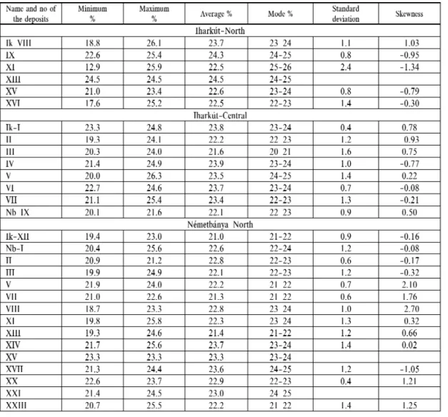
The number of sinkholes and deep sinkholes increased most. The length, width and areal extent of all bauxite accu- mulations are shown by Table 1. The deepest “sinkholes” were discovered at Vörösföld. They have also the smallest diameter probable sinkhole roots. Most bauxite accumulations are elongated paralell to the main tectonic directions. The rate of elongation is expressed by the ratio of their length and width, also indicated in Table 1. Most elongate is the Iharkút–V accumulation, having a ratio of 12.0. This is a typical canyon-type accumulation. The canyon is slightly sinuous
and has a variable width. The elongation ratio varies in most of the accumulations between 2 and 5. Only one completely isometric accumulation was detected (Iharkút–I).
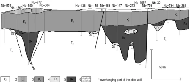
The thickness of the oveerburden. This is one of the most important characters both from the geological and mining points of view. It can be rather variegated even within the same bauxite accumulation as a conse- quence of tectonic disturbances. The smallest and largest thicknesses of the overburden were indicated in Table 1 separately for each bauxite accumulation. It is smallest in the north-eastern part of the deposit, being generally less than 10 metres. it varies from 3 to 39 metres in the northern Iharkút sector. It increases grad- ually to 100 metres in the central and southern sectors.
The thickness of the overburden abruptly increases to 136–310 metres in the western downfaulted Német- bánya sector .The Sármás sector at the north-western edge of the deposit is also downfaulted, the thickness of the overburden being 120 to 250 metres. Even greater thicknesses are expected further to the west.
We call the entire bauxite accumulation a bauxite sequence. The lithologic types composing the sequence will be discussed in the chapter on lithology.
Figure 8. Isopach map of Németbánya–XVIII bauxite accumulation
Legend: 1 – bauxite thickness <10m, 2 – bauxite thickness 10- 40m, 3 – bauxite thickness >40 m, 4 – fault line, 5 – borehole with high-grade bauxite, 6 – borehole with medium-grade bauxite, 7 – borehole with low-grade bauxite
8. ábra. A Németbánya–XVIII. telep vastagságvonalas térképe
Jelmagyarázat: 1 – bauxitvastagság <10m, 2 – bauxitvastagság 10- 40m, 3 – bauxitvastagság >40 m, 4 – törésvonal, 5 – jó minőségű bauxitot harántoló fúrás, 6 – közepes minőségű bauxitot harántoló fúrás, 7 – nem ipari minőségű bauxitot harántoló fúrás
Figure 9. Isopach map of Németbánya–I bauxite accumulation Legend: 1 – fault line, 2 – borehole with high-grade bauxite, 3 – borehole with medium-grade bauxite, 4 – borehole with low-grade bauxite, 5 – boundary of industrial grade bauxite, 6 – boundary of non-industrial grade bauxite 9. ábra. A Németbánya–I. telep izovonalas térképe
Jelmagyarázat: 1 – törésvonal, 2 – jó minőségű bauxitot harántoló fúrás, 3 – közepes minőségű bauxitot harántoló fúrás, 4 – nem ipari minőségű bauxitot harántoló fúrás, 5 – az ipari minőségű bauxit határa, 6 – a nem ipari minőségű bauxit határa
Figure 10. Contour map of the surface of the Triassic bedrock of the Németbánya–II bauxite accumulation, reflecting the thickness of the sinkhole filling bauxite
Legend: 1 – fault line, 2 – borehole with high-grade bauxite, 3 – borehole with medium-grade bauxite, 4 – borehole with low-grade bauxite, 5 – boundary of industrial grade bauxite, 6 – boundary of non-industrial grade bauxite, 7 – ele- vation m asl
10. ábra. A Németbánya–II. telepének triász fekü szintvonalas térképe Jelmagyarázat: 1 – törésvonal, 2 – jó minőségű bauxitot harántoló fúrás, 3 – közepes minőségű bauxitot harántoló fúrás, 4 – nem ipari minőségű bauxitot harántoló fúrás, 5 – az ipari minőségű bauxit határa, 6 – a nem ipari minőségű bauxit határa, 7 – tengerszint feletti magasság (m)
Figure 11.Isopach map of Németbánya–III bauxite accumulation (reflecting the coales- cence of the bauxite-filled sinkholes)
Legend: 1 – fault line, 2 – borehole with high-grade bauxite, 3 – borehole with medium-grade baux- ite, 4 – borehole with low-grade bauxite, 5 – boundary of industrial grade bauxite, 6 – boundary of non-industrial grade bauxite
11. ábra. A Németbánya–III. telep izovonalas térképe (az izovonalak jól mutatják, hogy a lencse morfológiája több töbör összeharapódzásának eredménye)
Jelmagyarázat: 1 – törésvonal, 2 – jó minőségű bauxitot harántoló fúrás, 3 – közepes minőségű baux- itot harántoló fúrás, 4 – nem ipari minőségű bauxitot harántoló fúrás, 5 – az ipari minőségű bauxit határa, 6 – a nem ipari minőségű bauxit határa
Figure 12.Isopach map of Pápavár–I bauxite accumulation
Legend: 1 – bauxite thickness <10m, 2 – bauxite thickness 10–20m, 3 – bauxite thickness 20–30, 4 – bauxite thickness >30 m, 5 – fault line, 6 – borehole with high-grade bauxite, 7 – borehole with medi- um-grade bauxite, 8 – borehole with low-grade bauxite, 9 – boundary of industrial grade bauxite, 10 – boundary of non-industrial grade bauxite, 11 – morphological step
12. ábra. A Pápavár–I. telep izovonalas térképe
Jelmagyarázat: 1 – bauxitvastagság <10 m, 2 – bauxitvastagság 10–20m, 3 – bauxitvastagság 20–30 m, 4 – bauxitvastagság >30 m, 5 – törésvonal, 6 – jó minőségű bauxitot harántoló fúrás, 7 – közepes minőségű bauxitot harántoló fúrás, 8 – nem ipari minőségű bauxitot harántoló fúrás, 9 – az ipari minőségű bauxit határa, 10 – a nem ipari minőségű bauxit határa, 11 – töbör pereme
The accuracy of our knowledge regarding the depositional fea- tures of the bauxite is influenced by the number of boreholes, pene- trating the bauxite sequence. Bauxite accumulations were penetrated by 5 to 20 boreholes. The largest number of boreholes were drilled in the Iharkút–V. accumulation, as many as 42.
The thickness of the sequence and of the bauxite. Both the aver- age and the maximum thicknesses are important properties. They have been both included in Table 1. The greatest average thickness of the bauxite sequence was observed in the Vörösföld–II bauxite accumulation with 51.1 metres. This is an extremely deep and nar- row sinkhole. The average thickness of the sequence is 31.0 metres in the Iharkút–V bauxite accumulation and 31.3 metres in the Németbánya–XXXI bauxite accumulation. Most of the bauxite accu- mulations in the Iharkút–Central and Németbánya–North sectors are Figure 13.Isopach map of Pápavár–II bauxite accumulation
Legend: 1 – bauxite thickness <10m, 2 – bauxite thickness 10–20m, 3 – bauxite thickness
>20m, 4 – fault line, 5 – borehole with high-grade bauxite, 6 – borehole with medium-grade bauxite, 7 – borehole with low-grade bauxite, 8 – boundary of industrial grade bauxite, 9 – boundary of non-industrial grade bauxite, 10 – morphological step,
13. ábra. A Pápavár–II. telep izovonalas térképe
Jelmagyarázat: 1 – bauxitvastagság <10 m, 2 – bauxitvastagság 10–20 m, 3 – bauxit- vastagság >20 m, 4 – törésvonal, 5 – jó minőségű bauxitot harántoló fúrás, 6 – közepes minőségű bauxitot harántoló fúrás, 7 – nem ipari minőségű bauxitot harántoló fúrás, 8 – az ipari minőségű bauxit határa, 9 – a nem ipari minőségű bauxit határa, 10 – töbör pereme
Figure 14.Isopach map of Pápavár–IV bauxite accumulation
For legend see figure 13.
14. ábra. A Pápavár–IV. telep izovonalas tér- képe
Jelmagyarázatát lásd a 13. ábránál.
Figure 15.Isopach map of Vörösföld–I bauxite accumulation (reflecting the coalescence of the bauxitefilled sinkholes)
Legend: 1 – bauxite thickness <10m, 2 – bauxite thickness >20m, 3 – fault line, 4 – bore- hole with high-grade bauxite, 5 – borehole with medium-grade bauxite, 6 – borehole with low-grade bauxite, 7 – boundary of industrial grade bauxite, 8 – boundary of non- industrial grade bauxite,
15. ábra. A Vörösföld–I. telep izovonalas térképe
Jelmagyarázat: 1 – bauxitvastagság <10 m, 2 – bauxitvastagság >20 m, 3 – törésvo- nal, 4 – jó minőségű bauxitot harántoló fúrás, 5 – közepes minőségű bauxitot harán- toló fúrás, 6 – nem ipari minőségű bauxitot harántoló fúrás, 7 – az ipari minőségű bauxit határa, 8 – a nem ipari minőségű bauxit határa, 9 – töbör pereme
Figure 16. Deep sinkhole-filling deposits of Németbánya in the South Central zone of the occurrence
Legend: 1 – Quaternary sediments, 2 – Middle Eocene Limestone, 3 – Upper Cretaceous terrestrial sediments, 4 – dolomite debris, 5 – bauxite, 6 – Triassic dolomite
16. ábra.A Déli-Központi terület németbányai szektorának jellegzetes mélytöbrös telepei
Jelmagyarázat: 1 – negyedidőszaki üledékek, 2 – középső-eocén mészkő, 3 – felső-kréta terresztrikum, 4 – dolomittömelék, 5 – bauxit, 6 – triász dolomit
Figure 17.Erosional remnants of sinkhole-filling bauxite (Pápavár) Legend: Ql= loess (Pleistocene), Bxba= bauxite sequence (bauxitic clay), Bxab= bauxite sequence (clayey bauxite), Bxa= bauxite sequence (clay), T3D = dolo- stone (Triassic), Dta= dolostone fragments (clayey), Adt= Clay with dolomit frag- ments, K3= Upper Cretaceous
17. ábra. Másodlagos (negyedidőszaki) fedő alatt megőrződött bauxitos töbörkitöltés maradványa (Pápavár)
Jelmagyarázat: Ql= pleisztocén lösz, Bxba = bauxitösszlet (bauxitos agyag), Bxab= bauxitösszlet (agyagos bauxit), Bxa= bauxitösszlet (agyag), T3D = triász dolomit, Dta=dolomittörmelék (agyagos), Adt = dolomittörmelékes agyag, K3= felső-kréta
Figure 18.Bauxite filling the "roots" of a sinkhole sec- ondarily covered by Quaternary sediments (Vörösföld) For legend see Figure 17
18. ábra. Mélytöbrök gyökérzónájában megmaradt bauxit (Vörösföld)
Jelmagyarázatot lásd a 17. ábránál
Table 1. Main depositional parameters of the accumulations
characterized by 20 to 29 metres of the average thickness of the sequence. It is 10 to 20 metres in the remaining sectors.
At the northern and southern edge of the occurrence only 2 to 10 metres were observed. The main bauxite accumulation in the Sármás sector (I) has only 6.5 metres average thickness of the sequence. The reasons for this areal trend are the configuration of the land surface and the depth to the main palaeo-karst-water level. Let us stress that the original thick- ness of the overburden has been changed at several places by later erosion.
The maximum thickness of the bauxite sequence. is of particular importance because the karstic sinkholes could develop vertically only until after reaching the main palaeo-karst-water level. Thus, theoretically, the maximum thickness of the baux- ite sequence indicates the minimum elevation of the palaeo-land-surface above the palaeo-karst-water level. It should be stressed that not all sinkholes reached during their development the palaeo-karst-water level. We prepared a map about the areal distribution of the maximum thicknesses of the bauxite sequence (Figure 19, 20). We distinguished on the map the areas of equal maximum thickness with the following categories < 20, 20–40, 40–60, 60–80 and >80 metres.
No maximum thickness values exceed 20 metres at the outer edges of the main bauxitic area. this thinnest area is largest in the north-western edge of the occurrence. The strip on the dowfaulted western side adjoining the main fault line is also characterized by maximum thicknesses less than 20 metres. This area of smallest maximum thickness is much thinner in the south-eastern edge of the occurrence. The areas of less than 40 and 60 metres maximum thickness are rel- atively small. For obvious tectonic reasons, this strip is completely absent along the western main fault line. The areas reaching 80 metres and beyond, are situated in the central part of the deposit. Maximum values were observed in the Iharkút–XII accumulation with 99.7 metres and in the Iharkút–V accumulation with 97.9 metres. Of course, there are also in these areas thinner bauxite-accumulations showing that not all the sinkholes have reached the main palaeo-karst- warer level.
The distribution of the maximum thickness is less straightforward in the Iharkút–North-eastern sector. It is less than 40 metres in the south-western part of the sector and it is less than 60 metres in the north-eastern part of it. The only exception is the Vörösföld–II accumulation were the maximum thickness of the bauxite sequence was 100.2 metres in the borehole Ik–515, however, with very small lateral extent (=a narrow “root” of a probably larger, sinkhole-filling deposit). The zone between the south-eastern sector and the main part of the deposit is not yet clarified in this respect.
It should be investigated in the frames of eventual future exploration projects.
Summarizing the above discussed features, our opinion is that the maximum thickness of the bauxite sequence, prob- ably reflecting a (local) topographic high, is one of the most important depositional features. It should be taken into account in all further exploration projects.
Average thickness of the bauxite is generally smaller than that of the bauxite sequence. In most cases it is 10 to 25 metres. It reaches only in the Vörösföld–II bauxite accumulation 48.0 metres, followed by the Németbánya–I accumu- lation with 34.0 metres and the Iharkút–XII accumulation with 32.0 metres.
Table 1. Continuation
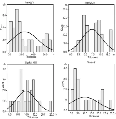
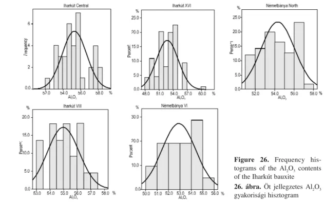
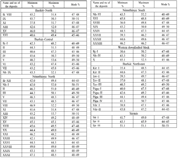
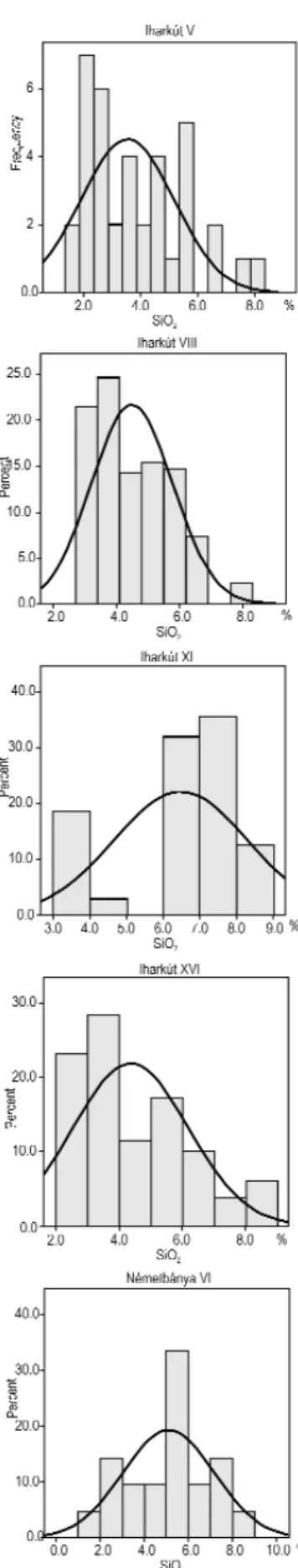
Maximum thickness of the bauxite. It is generally much greater than in the other bauxite deposits of the south-western part of the Bakony. We constructed frequency histograms for a better understanding of the distribution of the bauxite thickness for those bauxite accumulations, where bauxite was found in more than 10 boreholes. The 5 most characteristic histograms are presented in Figure 21. The corresponding Gauss-curves are also indicated on the histograms. Local protrusions of the footwall resulted in separated parts of the histogram in the Iharkút–V bauxite accumulation. A similar frequency distribution was observed in the Iharkút–VII bauxite accumulation. The thickness of the bauxite diminishes towards the north and it is only 13.0 metres in the Iharkút–XVI bauxite accumulation and 6.3 metres in Iharkút–XI.
Maximum thickness of the bauxite is apparently influenced by the degree of post-depositional erosion and par- ticularly by the presence of the original Late Cretaceous cover. In the Németbánya–North sector only 40.0 metre is the observed maximum bauxite thickness. In the Németbánya–South sector 5 to 10 metres were observed in most boreholes. On the other hand, much larger bauxite thicknesses were observed in the Iharkút–North-east sector. It is largest in the Vörösföld–II bauxite accumulation with 60.0 metres. Finally, in the Sármás sector it reaches only 25.3 metres.
Figure 19.Areal distribution of the maxi- mum thickness of the bauxite sequence Legend: 1 – bauxite, 2 – bauxite (exploited), 3–7 max. thickness of bauxite-sequence 3 – <20m, 4 – 20–40 m, 5 – 40–60m, 6 – 60–80, 7 – >80m, 8 – major fault line, 9 – boundary of mining district 19. ábra A bauxitösszlet vastagságának területi eloszlása
Jelmagyarázat: 1. bauxit, 2. kitermelt bauxit, 3-7 – max.bauxitösszlet-vastagság: 3 – >20m, 4 – 20–40 m, 5 – 40–60m, 6 – 60–80, 7 – >80m, 8 – fő törésvonal, 9 – kutatási részterület határa
The variablity of the bauxite thickness was studied in some sectors by variograms.The rate of influence of the baux- ite thickness varies from 35 to 70 metres in the Iharkút–Central sector, according to the calculations of BÁRDOSSY, BOGÁRDI(1981). It was detected by directional variograms that the rates of influence were longest in north-west/south- east direction. According to our experience, similar values are valid for the entire Iharkút deposit.
The areal extentof the bauxite accumulations varies from 1.0 to 12.0 hectars. It is in most cases between 2.0 and 5.0 hectars. The extent of the bauxite accumulations is largest in the central sectors and it diminishes toward the south.
Particularly small is the extent of the bauxite accumulations in the north-eastern sector. For a better understanding the length and the average width of the bauxite accumulations were indicated on Table 1. The sinkholes and the deep sinkholes were completely filled by the bauxite sequence. For this reason we may think, that they were saved from late erosion processes.
The surfaceof the bauxite accumulations is generally flat or slightly undulating. It is horizontal in most cases or they have only a gentle dip.
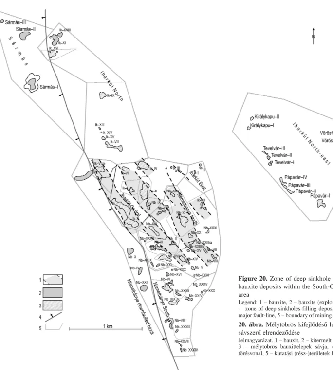
Figure 20. Zone of deep sinkhole filling bauxite deposits within the South-Central area
Legend: 1 – bauxite, 2 – bauxite (exploited), 3 – zone of deep sinkholes-filling deposits, 4 – major fault-line, 5 – boundary of mining district 20. ábra.Mélytöbrös kifejlődésű lencsék sávszerű elrendeződése
Jelmagyarázat. 1 – bauxit, 2 – kitermelt bauxit, 3 – mélytöbrös bauxittelepek sávja, 4 – fő törésvonal, 5 – kutatási (rész-)területek határa
Lithology of the bauxite deposit
We applied the following lithologic classification for the bauxite accumulations of the deposit:
1. Bauxite Al2O3> 42%, SiO2< 9,9%, ΣS < 0,6%
2. Clayey bauxite Al2O3> 40,0%, SiO210–19,9%
3. Bauxitic clay Al2O3> 25%, SiO2< 20,0%, modulus > 0,84 4. Kaolinitic red clay Al2O3> 20,0%, modulus > 0,84
5. Al-rich ferrite Fe2O3> Al2O3 6. Grey, pyrite bearing bauxite, clayey bauxite ΣS < 0,6%
7. Intercalations of dolomite debris
The above listed lithologic types are well distinguished, separate units. They were identified in the boreholes by the chemical analyses of the sampling intervals. The resulting average values are presented in Table 2. The number of the productive boreholes is also indicated in Table 2.
Figure 21. Selected histograms showing the thickness of the baux- ite
21. ábra. Egyes bauxittelepek bauxitvastagságának jellegzetes hisztogramjai
Table 2.Percentage of the main lithologic types
Table 2.Continuation
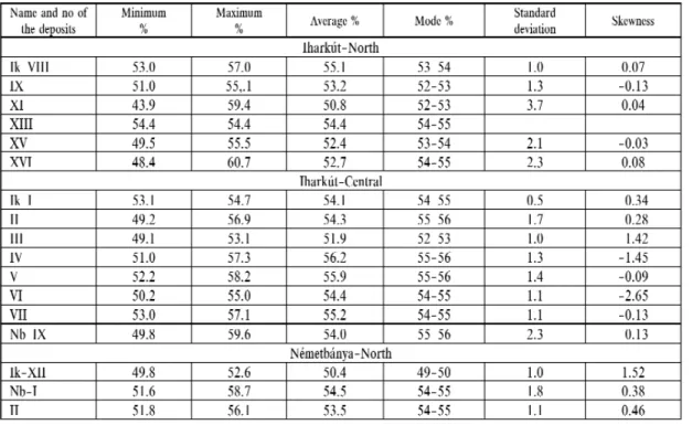
The bauxiteis present in all accumulations except the Németbánya–XXXIV and the Németbánya–XXXVI ones. The grade of the ore is in the entire deposit 52.7% (Al2O3), being higher than the grades of the bauxite in the Halimba, Malom-völgy, Szõc and Nyirád-east deposits, evaluated earlier. The averages (Al2O3) of the sectors are different, show- ing the following areal trend: best is the bauxite grade in the Iharkút–Central sector, with 60.8%. The grade of the ore gradually deteriorates towards the south, the Németbánya–North sector having 58.4% and the Németbánya–South sec- tor 56.0%. It also deteriorates in northern direction to 48.6% in the Iharkút–North sector. The grade is lowest in the Iharkút–North-eastern sector with 41.2%. On the other hand, surprisingly high grades were found in the downfaulted rim of the Németbánya area with 69.1%. Finally, it is 68.1% in the Sármás–I bauxite accumulation.
We evaluated also the numbers of the bauxite layers in each bauxite sequence, as presented in Table 3. The bauxite forms one single layer in 31 bauxite accumulations and two layers in 21 ones. Clayey bauxite and bauxitic clay occurs between the two bauxite layers. More bauxite layers were detected in only 5 bauxite accumulations. Most of the repeat- ed layers occur in the north-eastern sector of the deposit.
The average rate of clayey bauxiteis 19.0% for the entire deposit. It occurs in all bauxite accumulations except the Németbánya–XXII and –XXX ones. On the other hand, the small Iharkút–XIV accumulation consists entirely of clayey bauxite. It forms one to three layers in most accumulations. The only exception is the Németbánya–XI accumulation con- taining 6 clayey bauxite layers.
Table 3.Number of the layers of different composition in the bauxite accumulations
The average grade of bauxitic clayis 26.3% for the entire deposit. It was detected in all bauxite accumulations except the Iharkút–XIV and the Németbánya–XXII ones. The grade is very variable, being highest in the Németbánya–XXVI accumulation with 80.8%. The external rim of the sinkholes and deep sinkholes consists generally of bauxitic clay. The bauxitic clay forms generally one to three layers in the bauxite accumulations.
Red kaolinitic clayoccurs only in a few accumulations and with a very low grade. The highest grade was detected in the Iharkút–VI accumulation with 5.7%. The bauxite deposits of the south-western area of the Bakony Mountains con- tain generally more bauxitic clay.
Grey, pyrite-marcasite bearing bauxite and clayey bauxitewere notfound so far in the Iharkút bauxite. The reason for this absence is — in our opinion — the highly oxidizing environment right throughout the time of bauxite accumu- lation and also throughout most of early diagenesis.
No aluminium-rich ferritewas detected so far in the Iharkút deposit. This lithologic type is rather frequent in the Nyirád-east deposit (BÁRDOSSY2011). The main reason for the absence is — in our opinion — the absence of strong epigenetic processes, resulting in the mobilisation of the iron, in the upper part of the bauxite accumulations. No transported detritic grains, coming from a lateritic “iron-crust” were found in the Iharkút bauxite, either. On the contrary, they are frequent in the bauxite of the south-western part of the Bakony Mountains (e.g. BÁRDOSSY2011). The reason for this difference is the very small grain size of most extraclasts in the Iharkút bauxite, as detected by thin-section micropetrography and by “micro-mineralogic” investigations.
Intercalations of dolomite debriswere detected in several bauxite accumulations. Their material originates from the surrounding dolomite outcrops. When evaluating the borehole logs, we carefully distinguished them from the sub-verti- cal and overhanging “in situ” dolomite walls of the sinkholes. The dolomite debris occurs most frequently in the Iharkút–Central sector.
Table 3.Continuation
The lithologic types of bauxite sequences generally show a particular vertical order as observed e.g. in the Southern Bakony at the Malom-völgy, Szõc and Nyirád deposits (BÁRDOSSY2009, 2010, 2011). Bauxitic clay occurs in the low- est part of those accumulations. It is generally overlain by clayey bauxite, followed by bauxite. The top part of the accu- mulations consists of epigenetically altered clayey bauxite and bauxitic clay. They are reduced at several places to grey pyrite bearing clayey bauxite. This altered zone is usually 1 to 3 metres thick. This overall pattern was notobserved in the Iharkút deposit.
Micromorphology of the bauxite
Core samples selected from 86 exploratory boreholes and chip samples taken from the open-pits served as a basis for the lithological description of the textural properties of the Iharkút bauxite. The terminology we used to describe the sam- ples was the combination of BÁRDOSSY, NICOLAS1973 modified by MINDSZENTY1999. Sampling had been more or less continuous from the late ’70-ies up to the early ’90-ies, covering mainly the Northern, the Central and the Southern sec- tors of the occurrence. Micropetrographical analysis of 630 thin sections supported by XRD, SEM and TEM analysis of selected sub-samples permitted the identification of the mineralogy of the individual textural elements and the elabora- tion of a coherent microfacies concept. With the help of this concept not only some hitherto unknown details of the mech- anism of bauxite accumulation were revealed but also the close relationship between the morphofacies and the lithofa- cies of the bauxite could be established (MINDSZENTY1983, MINDSZENTYet al. 1984, D’ARGENIO, MINDSZENTY1995) (Figure 22). Later on this relationship was successfully used also in the micromorphology-based identification of the
expected morphofacies of other deposits during the very early stages of exploration. (MINDSZENTY1983; MINDSZENTYet al. 1984, 2005)
Unfortunately no such detailed sampling (and micropetrographical work) could be undertaken in the NE sectors of the occurrence discovered in the ’90-ies.
The study of samples originating from the area of the highest-grade deposits permitted the identification of the fol- lowing microfacies.
(1) Red autochthonous-oolithic bauxite (Plate IV, 1, 3, 4, 6). It consists of concentrically to sub-concentrically lam- inated ooids embedded into a pelitomorphic/microclastic matrix Within the ooids the degree of segregation of the alu- mina and iron-oxide rich phases (shown by the sharp vs diffuse boundary between the laminae of the cortex) is medium to weak. The apparent crystallinity, as shown by the presence of optically identifiable (>6 ìm) Al-hydroxide minerals (mainly boehmite, less frequently gibbsite), is also medium to weak. The boundary between matrix and ooids is charac- teristically diffuse. The ooid to matrix ratio varies from that of wackestones and floatstones to dense packstones.
Interpretation:Bauxites of this microfacies are considered to be the results of considerable in situ bauxitization of the muddy pre-weathered material deposited in the karstic sinkholes.
(2) Red, parautochthonous-clastic-oolithic bauxte(Plate IV, 5, 7, 8). Contains ooids of widely different degrees of segregation. Some of them are built up by distinct concentric to sub-concentric layers of coarse (>100 ìm size) gibbsite
Figure 22.The lithofacies concept of karst bauxites as suggested by D'ARGENIO, MINDSZENTY1995 Legend: 1 – pale-coloured, Fe-oxide-poor bauxite/bauxitic clay, 2 – Fe-oxide rich, red bauxite, 3 – dissolution-cavi- ties/channels, 4 – clay, 5 – limestone, 6 – marine sediments
22. ábra.Karsztbauxit-litofáciesek D'ARGENIO, MINDSZENTY1995 szerint
Jelmagyarázat: 1 – ferri-vasban szegény, fakó,bauxit/bauxitos agyag, 2 – ferri-vasban dús, vörös bauxite 3.oldási üregek, 4 – agyag, 5 – mészkő, 6 – tengeri üledék