ISSN Online: 2331-4249 ISSN Print: 2331-4222
DOI: 10.4236/wjet.2018.62B010 May 31, 2018 116 World Journal of Engineering and Technology
Water Related Disaster Management Supported by Drone Applications
Agoston Restas
National University of Public Service, Institute of Disaster Management, Budapest, Hungary
Abstract
Introduction: Climate change causes more articulated weather conditions: at some places experts count with more droughts while at other places with more floods. Even if features of droughts and floods are total different from each other both of them belongs to water related disaster: in case of drought amount of water is below required while in case of flood amount of water is too much. Drought and flood mean end positions of the water amount scale.
Other part drones are around us: more and more applications can be seen al- most all part of our life. Therefore it is very important to gather examples and finding possibilities to support water related disasters. Method: This article focuses mainly on author’s own practices and experiences using drone how- ever practices and experiences made by others were also adapted to the results of the study as well as the examples wrote in the relevant literatures. Results:
On the time scale there are three different options for using drone to support water related disaster management. Before floods drone can take river bed surveys as a kind of preventive application. During flood drone can support decision makers with the “eagle eye” view of the flooded area providing objec- tive and relevant information. After disaster experts can use drones for map- ping or remapping the affected area for making quick assessment about dam- ages caused by the flood. In case of forest fire we can also use the above ap- proach however in this article the flood examples of drone applications are dominated.
Keywords
Drone, Water Related Disasters, Forest Fire, Flood, Life Saving, Effectiveness
1. Introduction
The general feature of disasters is that the resources of the bodies responsible for How to cite this paper: Restas, A. (2018)
Water Related Disaster Management Sup- ported by Drone Applications. World Journal of Engineering and Technology, 6, 116-126.
https://doi.org/10.4236/wjet.2018.62B010 Received: May 7, 2018
Accepted: May 28, 2018 Published: May 31, 2018
DOI: 10.4236/wjet.2018.62B010 117 World Journal of Engineering and Technology elimination are limited. In order to reduce the limitation of resources, it is ap- propriate to examine at least in principle the possibility of applying new instru- ment or method; if the application of the new instrument or method can be con- sidered both professionally and economically feasible, it is unnecessary to post- pone its introduction. The professional efficiency is a necessary, but not a suffi- cient condition however the economic efficiency necessarily includes the fulfil- ment also of the first condition.
The wider use of drones raises the question of that this tool can be used or not to prevent and eliminate disasters, is it able to reduce the resource scarcity or to increase the effectiveness of preventive and intervening activities. This can be particularly useful in cases where the aerial reconnaissance could provide effec- tive assistance, but the cost of using conventional flying method—pilots on board—is very high and therefore managers avoid using it. This article try to show some applications to help decision makers how and why to use drone in case of water related disasters.
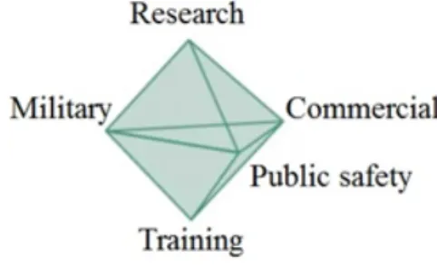
Drone can be used for different purposes; previously the military activity was the most frequently application [1] however nowadays the public safety [2] and even commercial use [3] raises dynamically. Each of this application requires trainings today and research for the future. Based on these applications Figure 1 show the hexagon model of using drone.
2. Water Related Disasters—Droughts and Floods
Most of researchers have no doubt about climate change. Two third of the Earth surface covered by water therefore higher average temperature means more evaporation potential. Even if the global humidity expected to raise distribution of falling rain or snow seems to be more hectic than nowadays [4] [5]. It means we can count with both serious drought and floods. Depending on the range of interpretation both drought and flood belongs to water related disaster: in the first case we have too little or letter than required water, in the second case we have too much or more than required water. Drought and flood mean the two extreme values of the water distribution function. Even if in both cases weather forecast plays a very important role to prevent disaster or mitigate its impact finding other tools or methods to reach the similar results are not an option for experts but on obligation. For reducing the effect of disasters governments dedicate
Figure 1. 3D haxagon model of drone ap- plications. Source: author.
DOI: 10.4236/wjet.2018.62B010 118 World Journal of Engineering and Technology authorities to be responsible for mitigation, experts use tools for early detection or prevention like fire weather index in case of drought or flooding models in case of flood. Author gives an overview of the possibilities of using drone in both cases.
3. Drought as Water Related Disaster—Forest Fire Prevention
In long term drought periods vegetation loses its moisture reducing the thre- shold of ignition [6]. Based on meteorological data models are able to predict the fire risk therefore forestry like to use fire weather indexes. Higher index means higher fire risk as potential for fire ignition and means also higher severity in case of fire because of the higher fire intensity. Even if we cannot reduce the val- ue of the index authorities or forestry can take some safety measures to reduce the ignition potential of fire or can make some actions to raise the effectiveness of fire detection or to reduce the size of burnt area.
In case of high fire risk authorized services can use drones for quick fire de- tection. Quick fire detection means smaller fire size therefore fire service can suppress or control it much easier and with higher effectiveness. In this case burnt area as well as damages will be limited. Looking at the fire curve of forest fire, the damage-time function gives an exponential dynamic that in ideal cir- cumstances diverges to infinity but in reality till natural barriers or extension of the forest.
It can be seen on Figure 2 if for any period Δt is reduced, the area burnt and thereby the damage caused by fire is reduced exponentially. The smaller the area affected by the fire, the smaller also the quantity of resources to suppress it. Fig- ure 3 shows real fire detection used by drone.
Less resource means not only direct save of the money spent fire services but it reduces also the risk of inadequate fire service. During long term forest fire- fighting fire brigades are far from departments which allocation were optimized
Figure 2. Damage-time function. It is a basic shape at uncontrolled forest fire. Source: author.
DOI: 10.4236/wjet.2018.62B010 119 World Journal of Engineering and Technology Figure 3. Fire detection by drone application. Red arrows show limited scale fires. Source:
author.
for the quick but short termresponses like building fires in the home city, car ac- cidents or even short term forest fires.
If using drone the average time from the fire ignition to the fire detection is less than the time of traditional fire report means that the drone is effective in expert view. If the reduced response time is able to save as much value forest as the costs of using drone means that the drone application is effective not only in experts view but also in economic view.
In most cases fires were caused by illegal or irresponsibly human activity [7]
therefore with drone patrols services can generate more responsible human be- havior. Well propagated drone patrols at a given area can be count as a kind of fire prevention.
Naturally, drone can support fire management also during the fire suppres- sion. Fire brigades arriving to fire front require quick information like location of hot spots, scale and size of fire, water resources, path ways to fire front, etc.
Traditional reconnaissance, that means walking around the area takes time, us- ing traditional aerial reconnaissance, which means ordering piloted aircraft, takes lot of money however using drone can support the first responders with limited costs very quickly and effectively.
4. Flood
In time scale we can divide drone applications very simply. Before flood we can count with drone application as a cheap but effective tool for prevention and preparation; it is a kind of pre-flood management. During flood drone can sup- port decision makers with real-time video supply to monitor the affected area or first responders with quick information; it is a kind of flood management. After flood we can use drone to make a quick assessment for the effective recovery; it is a kind of post-flood management. This time sectioning can be seen on Figure 4.
4.1. Pre-Flood Management
In case of serious drought the water level of rivers and many cases also of wa- ter reservoirs are very low [8]. In these cases experts can take a precocious
DOI: 10.4236/wjet.2018.62B010 120 World Journal of Engineering and Technology Figure 4. Time sectioning of drone application in case of flood management. Source:
author.
photo-surveying or remapping of the river basin with using drones as an exam- ple shows at Figure 5. During the flight the on board installed cameras can take photos or orthophotos and based on these high resolution photos we can create with special software even 3 dimensional models of the river basin [9] [10] [11]
[12]. We can notice not only the natural changes of the basin but also the illegal activities along the river side [13]. It can help later to avoid some water man- agement problem.
Moreover, taking high resolution photos along the river basin we can check not only the basin condition but also the condition of flood barriers [14]. In many cases flood barriers made of materials that found easily at the place it built therefore its structure is not homogeneous and its condition can change quickly along the river. There are examples for that the different or inhomogeneous ma- terial causes alternate compaction along the river side without invisible. Moreo- ver the differences can cause even barrier sliding or crown missing of the barrier as shows the example on Figure 6.
Besides the river basin or the flood barrier surveying to check the conditions of the dams can be even more important. Lower water level allows us to check that parts of the dam what is impossible at normal condition or high water level.
Using drones we can take high resolution photos along the dams even at a hid- den places and experts can evaluate many things like dam cracks, hair lines, corrosion of steel parts, deformations, etc. as an example shows at Figure 7 [17].
Management can also archive these high resolution photos taken by drones and later there is chance for not only re-evaluation them but also creating the “con- dition changing history” of the dam in time from it.
Naturally, based on drone made photos we can extend this changing history not only for the dam condition but also for the changing of the river basin or the flood barriers [18].
Other objects as bridges, reliefs, channels or pump stations as well as the nat- ural or planted vegetation located at the river-flats or flood basin can be also
DOI: 10.4236/wjet.2018.62B010 121 World Journal of Engineering and Technology Figure 5. Flood barrier and river-flats surveying at Bodrog-river, Hungary (2010), using mozaik photos made by drone. Source: author.
Figure 6. Crown missing of the flood barrier noticed by using drone during flood man- agement in Szendro, Hungary, 2010 (left) [15] and barrier sliding after flood at Sava river, Croatia (2010) [16] Source: author (left) and Fenix team, Croatia (right).
Figure 7. Precisions dam survey using drone to detect hair lines and cracks at the wall [17].
surveyed by drone. Experts can check easily the condition of the hidden parts of the bridges, using thermal camera they can monitor the normal work of the pump stations but can even detect easily the overheating of the engines. Moreo- ver the vegetation growth can be also under control to prevent proliferation.
DOI: 10.4236/wjet.2018.62B010 122 World Journal of Engineering and Technology
4.2. Flood Management
During flood management drone can be also a useful tool in the hand of experts.
With a high resolution mapping it can give precisions data about the flooding mechanism and the flooded area. This real-time information can support the management even if we have programs to predict the flooding mechanism.
Based on the objective information management can optimize the resources which are always limited in case of emergency.
Even if authorized services make many efforts to rise the resistance or limit the vulnerability of the society anytime can happen an unpredictable situation.
In these cases quick but objective information is required in which drone sup- ported real-time monitoring can help a lot.
Drone can re-mapping the given area and can detect unexpected events like trapped people in houses at the flooded area or water leakage at dams or flood barriers as examples show at Figure 8 [19] [20]. Based on the different wa- ter—soil temperature with a thermal camera drone can detect easily the water leakages at the flood barriers even if the scale of the leakage is very limited.
Based on quick detection of leakages management can control the problem before its escalation. Moreover thermal images can also refer to the condition of the flood barriers. With a high resolution photos we can notice even the defor- mation of flood barriers which stability is very important to protect the popu- lated area located many times behind the barriers. In case of slow deformation management can take safety measurements like making barriers stronger with sandy bags however in case of detecting large deformation ordering the evacuation
Figure 8. Drone made images about haus need help (top left) [19], thermal images of flood barrier during Danube flood management in 2013 in Hungary (top right) [20], wa- ter leakage of flood barrier (bottom left) [21] and water content measuring by thermal images made by drone [23].
DOI: 10.4236/wjet.2018.62B010 123 World Journal of Engineering and Technology can be the best solution to protect population [21].
Floods are typical example for the slowly developing disaster but the flash flood can occur suddenly. It is very dangerous in a hilly area because in the nar- row valleys water level can raise very quickly. Because of the narrow valleys flash floods can cause problems not only at the rainy areas but even far from it. It oc- curs so suddenly the people cannot escape from it, citizens or tourists can be trapped by the flushing water. Sometimes military resources also required to help [22]. In these cases drones can help a lot for first responders to identify the most critical places and to detect the trapped peoples. Aerial surveillance or monitoring can be very important because the normal roads are usually also flooded making traditional activity like ground reconnaissance impossible.
Using drone, management can classify the critical places and can optimize the always limited resources. Drone can give help for the management not only with the real-time information but even with real activity like supporting lifesaving, first aid or special logistic. Based on the above the flash flood is one of the disas- ters where drone application can be very important and effective tool in the hand of first responders.
Against the above nice opportunities experts should take into account that most of drone types are not suitable for using in very bad weather condition.
Usually operators should count with the power and turbulence of the wind but the cold temperature and high rate humidity can also be problems for the cheap but simply drones which are very effective in normal condition [24]. Unfortu- nately, rainy weather, even if it is only a slight rain, makes weather conditions impassable for drone flight.
4.3. Post-Flood Management
After high water moved away the flooded area remains deeply wet even for a long time, as Figure 9 shows. During this period traditional or normal life yet not possible however dedicated authorities, voluntary organizations and insur- ance companies can require quick assessments about damages to prepare the ef- fective recovery. Experts can support these requirements with drone applica- tions. Drone can re-map the affected area with taking different kind of photos, high resolution pictures or orthophotoes. Based on it experts can make a special database and they can compare the new situation to the previously. Flood stresses objects in the river basin therefore it is very important for dedicated disaster man- agement organizations like water directorates, civil protection, fire service to sur- vey them as soon as possible to prepare the maintenance or reconstruction.
In special cases drone can support even the guard duty or police service to keep the concerned area in high level safety. Depending on the situation a strong safety control is required to protect settlements from criminal attacks.
Based on the above it can be seen post-flood management drone applications are in many cases the same or very similar to the pre-flood drone management.
It is not an accident; post-flood management is a kind of prevention or depending
DOI: 10.4236/wjet.2018.62B010 124 World Journal of Engineering and Technology Figure 9. Even if high water is away using road is unpossible (left) but the affected area can be survillanced by using drone. Source: author.
on view point it is preparedness for the next flood. These actions make both re- sponsible organizations and society higher resistant and resilience against next flood.
5. Summarizing
Even if in most cases people think water related disaster means only flood it is not true. In case of drought amount of water is below required while in case of flood amount of water is too much but both of them can mean disaster. Drought and flood mean end positions of the water amount scale.
With drone applications fire service can detect hot spots earlier than the tradi- tional civil report. If the reduced response time is able to save as much value forest as the costs of using drone means that the drone application is effective not only in experts view but also in economic view.
On the time scale there are three different options for using drone to support water related disaster management. Before floods drone can take river bed sur- veys as a kind of preventive application. During flood drone can support deci- sion makers with the “eagle eye” view of the flooded area providing objective and relevant information. After disaster experts can use drones for mapping or remapping the affected area for making quick assessment about damages caused by the flood. In case of forest fire we can also use the above approach however in this article the flood examples of drone applications are dominated.
Based on the study author state that drone can be a very effective tool in the hand of well-trained experts to support water related disasters.
References
[1] Palik, M. (2013) Military Applications of Unmanned Aerial Vehicles (A pilotanelku- lilegijarmuvekkatonaialkalmazása); Unmanned Aviation for Professionals and Amateurs (Pilotanelkulirepulesprofiknakésamatoroknek) 320. Budapest, Hungary, 281-191.
[2] Restas, A. (2017) Drone Applications in Public Service (A dronokkozszolgalatial- kalmazasanaklehetosegei). New Hungarian Public Management (Uj Magyar Kozi- gazgatas), 10, 49-63.
[3] Palik, M. (2013) Short History of the Unmanned Aviation (A pilotanelkulirepules
DOI: 10.4236/wjet.2018.62B010 125 World Journal of Engineering and Technology rovidtortenete). Unmanned Aviation for Professionals and Amateurs (Pilotanelku- lirepulesprofiknakésamatoroknek) 320 p. Budapest, Hungary, 25-64.
[4] Hanko, M. and Foldi, L. (2009) Not Required Effect of Climate Change and Threat- ened Sectors (A klimavaltozasvarhatonemkivanatoshatasaies a kritikusszektorok).
Hadmernok, 4, 5-16. http://hadmernok.hu/2009_1_hanko.pdf
[5] Teknos, L. (2014) The Psychological Effects of Extreme Weather Conditions: The Importance of Crisis Intervention in Disaster Management. 22nd NISPAcee Annual Conference, Budapest, Hungary, 22-24 May 2014, 1-8.
[6] Verbesselt, J., Fleck, S. and Coppin, P. (2002) Estimation of Fuel Moisture Content towards Fire Risk Assessment: A Review. In: Forest Fire Research and Wildland Fire Safety, Proceedings of IV Int’l Conference on Forest Fire Research, Millpress Press, Luso, Coimbra, Portugal.
https://pdfs.semanticscholar.org/5d7c/76a2a1ee4ca7f5984be7a66866def092df59.pdf [7] Carmenta, R., Parry, L., Blackburn, A., Vermeylen, S. and Barlow, J. (2011) Under- standing Human-Fire Interactions in Tropical Forest Regions: A Case for Interdis- ciplinary Research across the Natural and Social Sciences. Ecology and Society, 16, 53. http://www.ecologyandsociety.org/vol16/iss1/art53/
https://doi.org/10.5751/ES-03950-160153
[8] Froehlich, D. (2017) Guidelines for Safety Inspection of Dams; DRIP: Dam Rehabilita- tion and Improvement Project; Report Number: Doc. No. CDSO_GUD_DS_07_v2.0.
[9] Restas, A. (2015) Drone Applications for Supporting Disaster Management. World Journal of Engineering and Technology, 3, 316-321.
https://doi.org/10.4236/wjet.2015.33C047
[10] Şerban, G., Rus, I., Vele, D., Breţcan, P., Alexe, M. and Petrea, D. (2016) Flood-Prone Area Delimitation Using UAV Technology, in the Areas Hard-to-Reach for Classic Aircrafts: Case Study in the North-East of Apuseni Mountains, Transylvania. Natural Hazards, 82, 1817-1832.
https://doi.org/10.1007/s11069-016-2266-4
[11] Barkoczi, N., Bertalan, L., Szabó, G., Deák, M., Kari, S.Z., Vizi, J.C., Zagorácz, M., Si, A., Riedel, M., Kohán, B., Mészáros, J., Szalai, Z., Szabó, O. and Nagy, B. (2017) Examples from the Boundaries of Geographic Survey: Architecture and Flood Mod- eling. Small Flying Drones, 127-156.
https://link.springer.com/chapter/10.1007%2F978-3-319-66577-1_5
[12] Rusnaka, M., Sladekab, J., Kidova, A. and Lehotskýa, M. (2018) Template for High-Resolution River Landscape Mapping Using UAV Technology. Measurement, 115, 139-151. https://doi.org/10.1016/j.measurement.2017.10.023
https://www.sciencedirect.com/science/article/pii/S026322411730653X
[13] Maipisi, A., Jordaan, A. and Restas, A. (2016) Locating Fault Lines of Flood Disaster Vulnerability and Susceptibility: Lessons to Governments, Development Agencies and Practitioners in Developing Countries. Protection Science (VedelemTudoma- ny), 1, 185-205. http://www.vedelemtudomany.hu/articles/13-maipisi-restas.pdf [14] Lenart, Cs., Biro, T., Burai, P. and Tomor, T. (2010) Application of Leser Scanner
(LIDAR) in Mapping and Planning Water Management (Legilezerszkenner (LIDAR) alkalmazása a vizugyiterkepezesbenestervezesben). 28th Hungarian Water Management Meeting, Sopron, Hungary, 7-9 July 2010, 258-263.
[15] Restas, A. (2017) Disaster Management Supported by Unmanned Aerial Systems (UAS) Focusing Especially on Natural Disasters. Zeszyty Naukowe Sgsp, 61, 25-34.
[16] Hucaljuk, M., Setina, N., Sosteric, N. and Restas, A. (2012) Croatia, Efforts and Re- sults for Different UAVs Applications. AUVSI International Conference, Tel Aviv,
DOI: 10.4236/wjet.2018.62B010 126 World Journal of Engineering and Technology Israel, 20-22 March 2012.
[17] Hackl, J., Adey, B.T., Woźniak, M. and Schümperlin, O. (2018) Use of Unmanned Aerial Vehicle Photogrammetry to Obtain Topographical Information to Improve Bridge Risk Assessment. Journal of Infrastructure, 24.
https://doi.org/10.1061/(ASCE)IS.1943-555X.0000393
[18] Coulthard, T.J. and Van De Wiel, M.J. (2012) Modelling River History and Evolu- tion; Philosophical Transactions of the Royal Society A Mathematical, Physical and Engineering Sciences.
http://rsta.royalsocietypublishing.org/content/370/1966/2123.article-info [19] 10 Years after Katrina (2015) Photoreport.
http://www.gettyimages.com/detail/news-photo/survivors-rescued-from-their-flood ed-lower-ninth-ward-news-photo/55320263
[20] Nagy, T. (2013) Hexum Involvement in the Flood Control. Report of Hexum Ltd., Hungary. http://www.hexium.hu/
[21] Olah, P. (2010) Both Suppression and Also Leakage Is Dangerous: It Is “Buzgar”
(Veszelyeselfojtani, de folynihagyni is: Ez a buzgar). Origo.
http://www.origo.hu/idojaras/20100301-buzgar-arvizveszely-fakadoviz-konkazatok.
html
[22] Padanyi, J. (2013) Experience in the Use of Military Forces in Flood Protection.
Academic and Applied Research in Military Science, 12, 59-66.
[23] Biro, T. (2017) Remote Sensing in Water Management (Taverzekeles a vizgazdalko- dasszolgalataban) Ludovika Open University, National University of Public Service.
http://docplayer.hu/68243659-Taverzekeles-a-vizgazdalkodas-szolgalataban-biro-tib or-nemzeti-kozszolgalati-egyetem-viztudomanyi-kar.html
[24] Bottyan, Zs., Tuba, Z. and Gyongyosi, A.Z. (2016) Weather Forecasting System for the Unmanned Aircraft Systems (UAS) Missions with the Special Regard to Visibil- ity Prediction, Hungary. Critical Infrastructure Research Project, 23-35.
https://doi.org/10.1007/978-3-319-28091-2_2

![Figure 6. Crown missing of the flood barrier noticed by using drone during flood man- man-agement in Szendro, Hungary, 2010 (left) [15] and barrier sliding after flood at Sava river, Croatia (2010) [16] Source: author (left) and Fenix team, Croatia (right](https://thumb-eu.123doks.com/thumbv2/9dokorg/1419819.120178/6.892.313.797.107.331/figure-missing-barrier-noticed-szendro-hungary-croatia-croatia.webp)
![Figure 8. Drone made images about haus need help (top left) [19], thermal images of flood barrier during Danube flood management in 2013 in Hungary (top right) [20], wa-ter leakage of flood barrier (bottom left) [21] and wawa-ter content measuring by th](https://thumb-eu.123doks.com/thumbv2/9dokorg/1419819.120178/7.892.316.802.651.1005/figure-thermal-barrier-danube-management-hungary-leakage-measuring.webp)
