XXXII
CONGRESSO GEOGRAFICO
ITALIANO
L’apporto della
tra rivoluzioni e riforme
A.Ge.I. - Roma
Roma, 7-10 Giugno 2017
a cura di
Franco Salvatori
G
L’apporto della
tra rivoluzioni e riforme
A.Ge.I. - Roma
Roma, 7-10 Giugno 2017
a cura di
Franco Salvatori
G
© 2019 A.Ge.I. - Roma www.ageiweb.it ISBN 978-88-942641-2-8
Licenza Creative Commons:
Attribution-NonCommercial-NoDerivatives 4.0 International (CC BY-NC-ND 4.0)
L’apporto della Geografia tra rivoluzioni e riforme. Atti del XXXII Congresso Geografico Italiano (Roma, 7-10 giugno 2017), a cura di F. Salvatori, A.Ge.I., Roma, 2019, pp. 3109-3114.
3109 Licenza Creative Commons:
Attribution-NonCommercial-NoDerivatives 4.0 International - ISBN 978-88-942641-2-8
GÁBOR MICHALKÓ1,ANNA IRIMIÁS2,KATALIN JUHÁSZ-DÓRA3,NOÉMI ILYÉS4
SOCIAL MEDIA PICTURE ANALYSIS TO EXPLORE HIDDEN TOURISM POTENTIALS OF GREEN ENERGY PLANTS
1. Introduction
A picture is worth a thousand words. However, nowadays the proverb is inside out, because of the digital picture recording technology people capture every minute of their life (mostly the selfie- makers), and it is almost impossible to proccess (view, systematize, store) this huge amount of photos. Few decades ago, photos were mostly taken during the travels and family events. At first, the enlargements of black and white frames by Agfa, Forte, Orwo and Kodak filled up the family photo album, then they were replaced by the colourised ones. The appearance of the smart phones was a huge breakthrough in the sweeping changement of the photography culture, as they made visible and reachable the captured moments in the same time with the photo-making, with the help of the mobile Internet. Instagram is the most popular application developed for smartphones, which enable the photographer to assign keywords to the pictures with a double cross symbol (#hashtag) therefore, the visual and written information are shared together. As the geographical names are often among the keywords, especially the names of settlements, one of the biggest online photo album offers an opportunity to carry out a wide range of different focused geographic surveys.
One of the main objectives of the Hungarian Scientific Research Fund program, named Research on the application of renewable energy utilization and landscape protection on sample areas of Hungary made within a consortional assocation of Eötvös Lor{nd University and Research Centre for Astronomy and Earth Sciences, Hungarian Academy of Sciences, is to evaluate the role of renewable (synonymous with green or alternative) energy in tourism. Within this research framework a question arises: does the renewable energy producing objects can be interpreted as landscape values and do they have enough touristic potential, to play a role in increasing the competitiveness of a given settlement or region. The solar-, wind-, water-, bio-, and geothermal energy producing structures can be interpreted as objects reflecting to the modern technology and industrial design which are attractive, therefore they can represent a landscape value. (Munkácsy, 2010). Solar cells, solar panels (energy sights), impressive wind turbines or smaller and larger water and geothermal power plants may also function as a separate tourist attraction, but these are more of complementary attractions in tourism at the given destination.
(Puczkó, Rátz, 2011). Because they are involved in the production of energy used by tourism services in addition to their aesthetic value, they result in substantial savings, and therefore the competitiveness-enhancing effects of these objects should be taken into account as well.
To certify or discard that the objects involved in the production of renewable energy are
1 Research Centre for Astronomy and Earth Sciences, Hungarian Academy of Sciences; Corvinus Univer- sity of Budapest, Institute of Marketing and Media.
2 Università degli Studi di Trento.
3 Corvinus University of Budapest, Institute of Marketing and Media.
4 Corvinus University of Budapest, Institute of Marketing and Media.
3110 ATTI DEL XXXIICONGRESSO GEOGRAFICO ITALIANO
interesting structures for the society to capture and share photographs, and likely to have a touristical potential as well, we conducted a relevant content analysis of the Instagram photo sharing portal. With the involvement of tourism and hospitality students of Corvinus University of Budapest, we examined tens of thousands of photographs on the basis of the hashtag of the 184 settlements, belonging to the three sample areas: Komárom-Esztergom county, Novoghrad- Nógrád Geopark and the Leader Assocation of Bükk region. The content analysis focused on two basic aspects: can you capture, if so, how the tourism potential of a given settlement based on the photos uploaded to the Instagram (1); does the objects that produce renewable energy appear in the images (2)? As a basic point for the study, it was assumed that the images reflect landscape values, that would outline the tourism potential of the given settlement and the renewable energy producing objects are represented among them.
2. Sample Area
The sample areas of the study are Komárom-Esztergom county (76 settlements), the Hungarian localities of Novoghrad-Nógrád Geopark (64 settlements) and the villages of the Leader Assoca- tion of Bükk region (44 settlements). The common in the regions covered by the administrative ar- ea of the 184 settlements, is the involvement firstly, in the landscape degradation due to the former industrial and mining activities, secondly, in the exploitation of renewable energy, thirdly, the in- volvement in tourism development as socio-economy remedy. Considering the fact that the Hun- garian Scientific Research Fund program no. K 112642 assigned only the sample areas and did not undertake a comparison, the database containing the information of the 184 settlements are aggre- gated, in the content analysis of the photos, uploaded to the Instagram. In this paper due to the ex- panse limit, we publish the results of the Komárom-Esztergom county sample area.
3. Methods
To answer our research questions, we used the content analysis which is a qualitative approach used in social science research methodology (Babbie, 2017). The point of this method is that the re- producement of the reality which was previously texted (such as report, news, rating), pictorial (such as photographs, films, TV shows) or mixed (such as billboards, websites, brochures) becomes the subject of the analysis. The content analysis method often used in the tourism research as it is becoming more and more difficult to obtain relevant information through questionnaires or inter- views in our accelerated and consumer behaviour focused world (Stepchenkova, 2012). At the same time the quarry of the information which can be collected from the Internet is expanding due to the online access of the touristical services and social media feedback surfaces. (Horváth, Mitev, 2015). The content analysis of photographs can not be regarded as a recent methodology in tour- ism research since we could met such attempts, before the appearance of the digital technology, but the online sharing of the photos made the examinations easier and the results can be consid- ered to be valid, more than previously (Irimiás, 2015). The information existing together with the photos, particularly the record of the GPS coordinates, made researchable not only the pictorial content but the spatial and time aspects of the tourisical behaviour as well. (Kádár és Gede, 2013).
Instagram is a smartphone-optimized application created in 2010 which allows the people to share pictures made with smartphones, often selfies, and follow the photos shared by other people with us and these photos are virtually accessible to anyone through the website of the Instagram.
The public access can be ensured on the following way: when someone sharing a photo, a limited
HIDDEN TOURISM 3111
number of tags (up to 30) can be assigned to that photo, so if someone tagged the image with the given settlement name, then it will be included in the database containing the given town name.
And in case of search, all photos under this tag (geographic name) will be displayed. It means that it can be thousands, tens of thousands, hundreds of thousands photo which is appropriate to ana- lyze, but, for example, in case of Budapest, it means over a million5 photographs. In addition to la- beling, any individual who wishes to have followers or any company, govermental or civil associa- tion who want to use this channel of marketing communication, can also have an independent in- stagram page, where they can upload photographs, depending on the user conditions, of course.
In the research which took place between the 13th of February and 9th of March, 2017 the students of the Corvinus University of Budapest took part and only those photos has been analysed according to the content which had a hashtag with the name of the settlement. We searched for all the 184 settlement names in accented and non-accented spelling way and through this the settlements names with the missing letters or with spelling mistakes were taken into account as well. In some cases, however, the search was unsuccessful, because the name of the settlement was partially or fully the same with other foreign words, or it even covered a popular Hungarian term (eg Tata). On the other hand in the great majority of the cases the Instagram is considered to be suitable for the content analysis of the settlement name tagged photos. During the observation, the well prepared contributors focused on two main aspects. The first was to capture the dominant landscape elements connected to the given settlement, the second was to detect the renewable energy producing structures. We recorded in an Excel sheet the total number of photographs, the names (descriptions) of the dominant landscape elements and the number of photographs connected to them. As a dominant landscape element, we have interpreted all the objects that are already relevant in the tourism of a given place or it can be make relevant with development. The dominant landscape elements are belonging to the material conditions of the tourism, such as the basic infrastructure (railway station), attraction (landscape, church), touristical infra- (e.g. bath) and suprastructure (e.g. catering unit, accomodation, shop). The contributors involved in the study made decisions based on a simple review, which objects can be classified among the first, second, or third most photographed (dominant) landscape elements. It was very common that the content of the uploaded photos did not allowed, or limited us to capture the dominant landscape element. The review method has been slightly made more simple, with respect to more than 100 dominant landscape elements, we have only confined ourselves to this fact. In the case of renewable energy photographs we proceeded in the same way, the existence and the specifics of these objects were recorded in a separate column. If the dominant landscape element was recognizable, we did not distinguish that this is the primary content of the image or it is just the background, as the selfies were not excluded neither if they were made in a tourism- friendly landscape environment.
4. Results
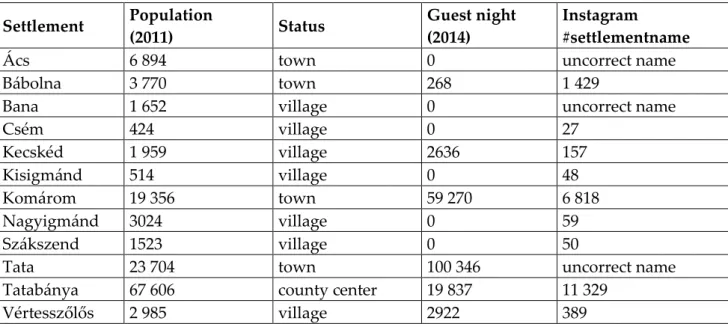
In this paper we focus only on those settlements of Komárom-Esztergom county, where pic- tures of renewable energy structures are relevant. Instagram users uploaded pictures related to re- newable energy in case of 12 settlements (out of 76 settlements). These include settlements of va- roius size and status, from Tatabánya, where the population is nearly 70,000 to Csém where the same number is 421, from the county center to the village. There is also a wide spectrum of these settlements on the tourism palette, from the busiest Tata to the non-guest areas (tab. 1).
5 6.290.763 photo were uploaded to Instagram with #budapest label on 20th of April, 2017.
3112 ATTI DEL XXXIICONGRESSO GEOGRAFICO ITALIANO
Settlement Population
(2011) Status Guest night
(2014)
#settlementname
Ács 6 894 town 0 uncorrect name
Bábolna 3 770 town 268 1 429
Bana 1 652 village 0 uncorrect name
Csém 424 village 0 27
Kecskéd 1 959 village 2636 157
Kisigmánd 514 village 0 48
Komárom 19 356 town 59 270 6 818
Nagyigmánd 3024 village 0 59
Szákszend 1523 village 0 50
Tata 23 704 town 100 346 uncorrect name
Tatabánya 67 606 county center 19 837 11 329
Vértesszőlős 2 985 village 2922 389
Table 1. The settlements involved in the observation of Komárom-Esztergom county. Source: Hungarian Central Statistical Office, own observation.
In the narrowed list of the samples of Komárom-Esztergom county, we can find three names of settlements which are unsuitable for keyword inspecting on Instagram. (There is no caption for
#ács on Instagram, however related to #acs more than 166 thousand photo can be found. But be- cause it also abbreviates many US scientific societies the filtering is not possible under these tech- nical conditions. The situation of #tata is similar to this, as it is also a name of an Indian multina- tional company with 800,000 images, and #bana a Japanese comic book icon with more than one million records.) The fact that the most popular touristical settlement Tata-related hashtags can not be searched in the database is a very serious limit in the examination.6
Analyzing the information in Table 1, it can be stated that the larger the population number of the settlement, the higher the status of the settlement in the hierarchy, and the higher the number of guest nights, the greater the likelihood that the Instagram will record and distribute a significant amount of photographs. The number of inhabitants, in some respects, in connection with the status of the settlement, ensures the volume of the local users of the Instagram (with their relatives and acquaintances), and the tourists also increase the number of hashtags containing the name of the settlement. As, one of the criteria for declaring a settlement as a city in Hungary, is the quality of the touristical function, therefore the higher level of gradation in the settlement hierarchy makes it possible to find the objects of interest to visitors.
6 Since the companies, local governments, civil associations can upload photos related to their own pro- file, we could notice renewable energy producing structures in these photos, and this is the reason why Ács, Bana and Tata could be represented in the narrowed sample of Komárom-Esztergom county.
HIDDEN TOURISM 3113
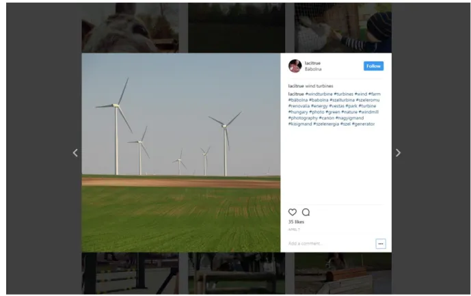
Figure 1. Landscape picture illustrating wind turbines with #Bábolna hashtag on Instagram.
The structures suitable for the producing renewable energy in the content analysis of Komár- om-Esztergom county were wind turbines without exception (fig. 1). Despite the fact that the aver- age wind speed in Hungary is relatively low (Bihari et al., 2011), imposing structures operated by the north-west and north winds can be found mainly in the parts of the county, which are close to the M1 motorway, but we have seen Instagram photographs at further regions as well. The general characteristic of these pictures is that they not only display the wind turbine itself but also fit it into the surrounding environment.
The wind turbine, as the dominant landscape element reflecting from the images analyzed in connection with a settlement, was related only in connection with Kisigmánd. In 11 of the 48 imag- es uploaded, the structures producing wind energy were the central themes of photos with a hashtag containing the village name. Considering the fact that Kisigmánd does not really have a tourist attraction, it is reasonable to consider that only wind turbines next to the M1 motorway in the municipality represent the objects which are worth to share on Instagram. In case of the other settlements, the wind turbines occured in a small number on the Instagram pictures. In the cities with significant tourist demand, the iconic attractions represented the dominant landscapes, such as the view from Kőhegy in Tatab{nya, the Erzsébet ‛ridge in Kom{rom, the horse-riding events in Bábolna, and from the villages that do not have high tourist traffic, mostly traditional landscape and village illustrated pictures were uploaded. Vértesszőlős represented a remarkable exception, since the most dominant landscape element was not the national or even internationally well- known prehistoric site (Archeological Exhibition of the Hungarian National Museum), but the Catholic church of the village, which is under heritage protection in the village.
3114 ATTI DEL XXXIICONGRESSO GEOGRAFICO ITALIANO
Conclusion
The photo content analysis is one of the procedures used in social science research, and when we analyzing tourism-related issues, the reflection of local residents or tourists has a particular importance. From the picture it can be found out what is important, interesting and entertaining for the creator so the researcher can evaluate perceptions of the place without knowing the views of the people concerned either in orally or in written. Instagram – as it provides the images with the tags identified by the name of the settlement – provides an unique opportunity to examine the given touristic destination. The present study evaluated the appearance of renewable energy structures on Instagram photos, but did not ignore the reflections of the touristical attractions of the examined settlements. It can be stated that: Instagram partially appropriate to make a tourism- oriented study of Hungarian settlements, because their name are often mixed with hashtags recorded in other languages, so the filtering of the images is extremely problematic (1); the content analysis of thousands of pictures uploaded, related to each settlement name, is a time-consuming task and the subjectiveness of the contributors can be involved in the result (2); despite the fact that the majority of the images are selfies, representing the creator (relatives or acquaintances), the touristical potential of the given settlement can be evaulated according to the environment or background (3), photos showing renewable energy structures can be found on Instagram, but these rarely reflects to dominant landscape elements, which are the main points of the visual reflexion of the given settlement.
Acknowledgement
The research was supported by Hungarian Scientific Research Fund program no. K 112642. The authors hereby wish to express their gratitude to the sophomores of tourism and hospitality faculty of Corvinus University of Budapest, (special thanks to Suchovsky Romulus for the coordination) who helped creating the database with their seminar collections.
References
Babbie, E., (2017), A társadalomtudományi kutatás gyakorlata, Balassi Kiadó, Budapest.
Bihari, Z., Szalai, S., Bozó, L., (2011), Éghajlat. In: Kocsis K., Schweitzer F., (2011), Magyarország térképekben, MTA Földrajztudományi Kutatóintézet, Budapest, pp. 46-51.
Horváth, D., Mitev, A., (2015), Alternatív kvalitatív kutatási kézikönyv, Alinea Kiadó, Budapest.
Irimiás, A., (2015), Filmturizmus, Akadémiai Kiadó, Budapest.
K{d{r, ‛., Gede, M., , Where Do Tourists Go? Visualizing and Analysing the Spatial Distri- bution of Geotagged Photography , Cartographica: The International Journal for Geographic Infor- mation and Geovisualization, 48, 2, pp. 78-88.
Munkácsy, B., (2010), A területi tervezés szorításában: A szélenergia-hasznosítás hazai le- hetőségei , Területfejlesztés és Innováció, 4, 2, pp. 20-27.
Puczkó, L., Rátz, T., (2011), Az attrakciótól az élményig, Akadémiai Kiadó, Budapest.
Stepchenkova, S., (2012), Content analysis. In: Dwyer L., Gill A., Seetaram N. (eds), Handbook of re- search methods in tourism. Quantitative and qualitative approaches, Edward Elgar, Cheltenham, pp.
443-458.