SEISMIC SAFETY OF THE PAKS
NUCLEAR POWER PLANT
SEISMIC SAFETY OF THE PAKS NUCLEAR POWER PLANT
.
:
.
Authors
B A LLA , ZOLTAN C H IK A N , G E Z A
C H IK A N -JE D L O V S Z K Y , M A RIA D U DKO, A N TONINA HORVATH, F E R E N C K O K A I,A N D R A S
M A R O S, GYU LA M A R O SI, SANDOR
M ONUS, P E T E R
R A N ER , G E Z A (w ith co-authors) S C H W E IT Z E R , FE R E N C SZABO, ZOLTAN (w ith co-authors)
S Z E ID O V IT Z , G Y O Z O T O T H , L A SZLO
T O T H , TAM AS T U R C Z I, G A B O R
VARGA, P E T E R
SEISMIC SAFETY OF THE PAKS NUCLEAR POWER PLANT
Edited by
SANDOR MAROSI and ATTILA MESKO
A K A D E M IA I K IA D O , B U D A PEST 1997
Preparation for printing carried out at the
Geographical Research Institute, Hungarian Academy of Sciences (GRI HAS)
Computer typesetting and layout:
ESZTER GARAI-EDLER, ZOLTAN KERESZTESI
Technical editor:
ZOLTAN KERESZTESI
Technical staff:
JANOS BALOGH, LASZL6 BASSA, MARGIT MOLNAR, ISTVAn P06R
Cover photo by MIKLOS BEREGNYEI
Cover design by ISTVAN KABACS
ISBN 963 05 7452 7
© FERENC SCHWEITZER, director of the GRI HAS, project leader, 1997
All rights reserved. No part of this book may be reproduced by"any means, or transmitted ot translated into machine language without the written permission of the publisher
Published by Akademiai Kiado, H—1117 Budapest, Prielle Kornelia u. 19-25
Printed in Hungary byE X E O N Bt.
C O N T E N T S
PREFACE (E d ito rs)...9
CHIKAN, Geza, CHIKAN-JEDLOVSZKY, Maria, KOKAI, Andras and TURCZI, Gabor: Geological research in the Paks region 1985-1994 ... 11
1. Introduction...11
2. Surface geological m a p p i n g ... 1 2 3. Borehole survey ...17
4. Artificial exposures ...19
5. Synthesis of the geological fo rm atio n s... - ...20
6. GIS d a t a b a s e ... 21
R e fe re n c e s ... 24
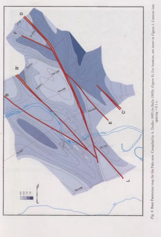
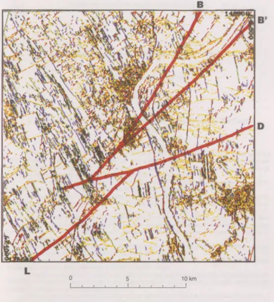
BALLA, Zoltan, DUDKO, Antonina and MAROS, Gyula: Neotectonics o f the Paks a r e a ... 33
1. In tro d u ctio n ... ... 33
2. Tectonics of the b a s e m e n t ... 34
2.1. Gravity and magnetic anomaly p a tte rn ... 34
2.2. Gravity effect of the b a s e m e n t... ...35
2.3. C o n clu sio n s... ...36
• 3. Tectonics of the M iocene s e q u e n c e s ... 37
3.1. F a u l t s ... 37
3.2. S eq u e n c es...38
3.3. C on clu sio n s... 39
4. Tectonics of the Quaternary sequences...40
4.1. Deep horizons: high-resolution seismic sections ... 41
4.2. Near-surface horizons: measurements of j o i n t s ...41
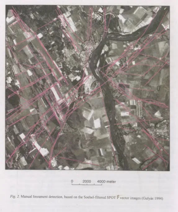
4.3. Earth’s surface: lineaments on satellite images ...43
4.4. C o n c lu sio n s... 43
5. S u m m a ry ... 43
R e fe re n c e s ... 45
RANER, Geza and SZ A B 6, Zoltan (eds): Geophysical explorations in the
region o f P a k s ...61
1. Review of the geophysical measurements commissioned by the Paks Nuclear Power Plant C o... 61
2. Neotectonic investigations, determination o f active or presumably active faults . 62 3. Connection between tectonics and the e arth q u ak es... ... 63
4. Digital study of the remote sensing images (Gulyas, A g n e s ) ... 64
5. Airborne geophysical investigations ...65
6. Gravity surveys (Szab6, Zoltdn and Pancsics, Z o l t d n ) ... 65
7. Magnetic surveys (Kovacsvolgyi, S a n d o r ) ... 67
8. Tellurics and magnetotellurics (Madarasi, Andras, Nemesi, Laszlo and Varga, G e z a )...67
9. Seismic m easurem ents...68
9.1. Refraction m e a su re m e n ts ...69
9.2. Reflection measurements (D. Lorincz, Katalin and Redler-Tatrai, Marianna) . 69 9.3. Shallow seismic measurements (Guthy, T i b o r ) ...70
9.4. Seismic measurements on the Danube (Toth, Tamds) ...71
9.5. Further tasks of seismic m e a su re m e n ts... 71
10. Geoelectric measurements (Nemesi, Laszlo and Stickel, J a n o s )... 72
11. Engineering geophysical soundings (Fejes, Imre and Stickel, J a n o s ) ...72
12. Ground penetrating radar measurements (Pattantyus-A., M iklos) ...73
13. Sonic logging, P, S and Q measurements (Toros, Endre) ...73
14. Well-logging (Bucsi Szabo, L 3 s z l 6 ) ...74
15. S u m m a r y ...74
R eferences...75
SZEIDOVITZ, Gyozo' and VARGA, Peter: » Earthquake hazard of the Paks N P P ... 95
1. Introduction...95
2. Review of studies on seismic hazard of the Paks NPP ... 95
3. On the detection of earthquakes so u rc e s ... 102
4. A review on larger earthquakes occurred in the Carpathian-Basin and their geological ch aracteristics... 103
6
4.1. Fault zones affecting the Pannonian layers ... 105
4.2. Traces referring to Pleistocene and Holocene m ovem ents... 105
4.3. Stability of earthquake so u rc e s... 107
4.4. Investigation of the contours of b lo c k s ... 107
4.5. The largest earthquake in the vicinity of the Paks N P P ... 108
5. S u m m a r y ... 110
R e fe re n c e s ... ... I l l i TOTH, Laszlo and MONUS, Peter: The microseismic monitoring network of the Paks N P P ... 113
1. Introduction ... 113
2. Scientific and technical c o n c e p t ... . ... 114
3. Site selection criteria for seismic s t a t i o n s ... 114
4. Station d e s c r ip tio n ... 115
5. Data analysis and seismological interpretation ... 115
6. Results ... 116
R e fe re n c e s ... 117
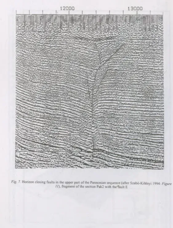
TOTH, Tamas and HORVATH, Ferenc: Neotectonic investigations by high resolution seismic p ro filin g ... 123
1. Introduction... 123
2. Introduction to seismic p r o f ilin g ... 124
2.1. Basics of seismic p r o f ilin g ... 124
2.2. Processing and interpretation... ... 126
3. Multichannel high-resolution seismic survey carried out on the river Danube . . 127
3.1. Surveying technique and field p a ra m e te rs ... ... 127
3.2. Processing ... 128
4. Reprocessing o f onland high-resolution seismic sections measured by ELGI . . 130
5. In te rp re ta tio n ... 131
5.1. Identification of stratigraphic and structural f e a t u r e s ... 132
5.1.1. Identification o f the Quaternary/Pannonian unconformity ... 132
5.1.2. Identification and correlation of f a u l t s ... 132
5.2. Age of faulting and the problem of fault capability and present activity . . . 135
6. C o nclusions... 137
R e fe re n c e s ... 138
MAROSI, Sandor and SCHWEITZER, Ferenc: Geomorphological investigations
in the environs of the Paks N P P ... 153
1. Introduction...! ... 153
2. Atectonic j o i n t s ... ... ... 153
3. A sketch of geomorphic evolution and reconstructed p a leo g e o g ra p h y ... 154
3.1. Paleogeography of sediments underlying fluvial deposits in the environs of the power p l a n t ... 155
3.2. Orientation o f the valley network on the M e z o f o ld ... 156
3.3. Base levels along the margin of the Great Plain and shifts o f the channel o f the D a n u b e ... 157
3.4. Channel modifications of the D a n u b e ... 158
3.5. Interfluvial valleys between loess ridges and the ancient Sarvfz stream . . . 159
4. Landforms occurring in the area (geomorphological m a p ) ... 159
4.1. Fluvial erosional and accumulational landforms ... 160
4.2. Landforms of complex g e n e sis... ... 161
4.3. Wind erosion (deflational) la n d f o r m s ... 162
4.4. Man-made landform s... 163
5. Conclusions . . . .*... 163
R e fe re n c e s ... 164
G lo ss a ry ... 177
CLOSING REMARKS {E d ito rs)... 191
Preface
This book presents a selection of papers relating to the re-evaluation o f the seismic safety of the Paks Nuclear Power Plant. Seismic safety analysis is understood as the quantitative estimation o f the earthquake hazard at a site. Engineering solutions are generally available to mitigate the potential vibratory effects of quakes through design.
However, there are no adequate solutions for mitigating the effects of permanent ground displacement phenomena such as surface faulting, subsidence etc. For this reason, in the re-evaluation process the potential for surface faulting has been investigated with special care. Publications of the International Atomic Energy Authority (IAEA) provide guidelines and recommends procedures to adopt in the consideration of earthquakes and associated topics for nuclear power plant siting but there are no internationally accepted procedures for the evaluation o f the seismic hazard which would be appropriate for assessing the seismic performance o f existing nuclear power plants. The seismic safety re-evaluation, therefore, has been based on a thorough analysis incorporating geological, geophysical, seismological and earthquake engineering information in a systematic way, similar to those applied for assessing the seismic condition in nuclear power plant siting.
In the evaluation of the probability and intensity of future quakes the study o f past events and processes are essential. Approximations differ from each other concerning the remoteness of the past as well as in their direct or indirect relation to earthquakes. Evidently, the more recent these events and processes are and the closer they are related to quakes, the more reliable conclusion can be drawn. History o f past earthquake activity show the closest relation with seismic hazard. Hungary belongs to the regions o f low to moderate seismicity where the prediction of future seismic activity should only be based on an interval of observations with the duration of thousand years, much shorter than the return period o f large destructive intraplate earthquakes. Rethly (1952) collected all events registered since 456 AD in his catalogue of earthquakes in the Carpathian basin. However, even this catalogue is far from being complete, moreover, only data from the last two or three centuries might be regarded reliable. Obviously one should involve additional data in the evaluation of seismic hazard; geological, geophysical, geomorphologic data alike.
On behalf of the Paks Nuclear Plant Co. Ltd. comprehensive investigations have been conducted in the area of the power plant and in its wider surroundings for more than ten years to evaluate seismicity and to assess safety of its operation. In the course o f these studies a great amount o f geological, tectonic, geophysical, seismological, geotectonical and geomorphological data and knowledge have accumulated in the form of reports, maps and publications.
Recognizing that the value of the accumulated material may have significance beyond a single industrial application, the Paks Nuclear Plant Co. Ltd. decided to publish
a concise summary of the research work o f the last ten years thus making the results of investigations available for the domestic and international audience of geosciences and experts in nuclear energetics. A volume of invited papers, sum m arizing the results seemed to be a proper tool for demonstrating possibilities offered in various fields o f earth sciences for the assessment o f seismic safety. Each o f the invited contributions has a character of a summary, since authors should outline the methods, key points and conclusions of several reports on previous extensive mapping activities or measurements sometimes comprising several hundred pages. In spite o f its tutorial character we hope the volume can be useful for geoscientists as well, due to the fact that no synthesizing work o f this kind has been published yet. M ost of the studies are compiled by project leaders and among the authors are listed most o f those who have contributed to the assessment of the earthquake hazard.
The description of geological surveys of the wider and closer surroundings and a summary and evaluation of tectonic and neotectonic evidences are followed by a summary of various geophysical measurements and the evaluation of seismological data. Seismic measure
ments carried out on the Danube constitute a separate chapter because o f its vital import
ance in deciding the presence or absence o f capable faults (transgressing youngest subsurface geological formations). A chapter on geomorphology serves as the closing part o f the investigations.
Introducing their topics some of the authors found it necessary to present the general scope and significance of their research and to provide a short historical overview as well as an insight into the!methodical details. Evidently these descriptions sometimes overlap.
Similarly, some items occur in more than one list of references. However the editors deliberately avoided cutting redundant information since their aim was not so much to publish a monograph but to prepare a collection o f authoritative articles, also usable as stand-alone studies, that collectively comprise or affect the seismic safety of a nuclear power plant. This also implies that the authors of the volume should be considered as independent experts taking all competence of and full responsibility for the conclusions in their exclusive field of research.
A glossary o f terms has been compiled in order to help the nonspecialist.
W e wish to express our sincere thanks to the staff of the Paks NPP Co. Ltd. for the support provided for the research activities as well as the publication of the present volume.
We are especially grateful to Jeno Balogi, development manager, for his help and assistance. At last, let us express our hope that specialists and nonspecialists should both be served by the collection o f review papers of this volume.
Budapest, May 1997
Editors
10
Seism ic safety o f the P aks N uclear P ow er Plant pp. 11-32.
Geological research in the Paks region 1985-1994
CH IK A N , G6za, C H IK A N -JED L O V SZK Y , Mdria, KOKAI, AndrSs and TU RCZI, GsSbor
H ungarian Geological Survey, H - l 143 Budapest, Stefania ut 14.
1. In tro d u c tio n
The H ungarian G eological Survey has been taking part in the geological research in the environs o f the Paks Nuclear Pow er Plant since 1985. M ost o f the results in the area W o f the Danube w ere supplied by geological investigations to support exam inations concerning the N PP’s seism ic safety. In the surroundings o f the N PP geological works for the planned extension and for the support o f seism ological exam inations, carried out by numerous institutions and experts were the most productive. A ctivities o f the Transdanubian D ivision o f the Geological Institute o f Hungary (M AFI), o f the experts from different divisions o f the H ungarian Geophysical Institute (ELGI), from the G eodetical and G eophysical Research Institute (Sopron) (GGKI), from the D epartm ent o f Geophysics Eotvos Lorand U niversity (B udapest) (ELTE), from the G eophysical E xploration Com pany (Budapest) (GKV), and o f A. F. G racsov and his colleagues from the G eophysical Institute o f M oscow should be mentioned, w ho took part in the assessm ent o f seism ic safety o f the area between 1985 and 1991. In cooperation with the m easuring team o f ELG I and considering the recom m endations o f the Scientific Coordination C om m it
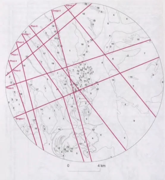
tee, Hungarian G eological Survey issued a sum m ary in 1992 based on the elaboration o f earlier data. In 1994 an other im portant w ork was published sum m arizing the geological conditions in the area, evaluating tectonical conditions and adapting the results o f the accom plished projects to GIS. The present study sum m arizes the results and m ethods o f the geological studies in the surroundings o f the N PP (Figure I) pointing out inform ation about the surface and near-surface geological form ations. It provides an outline o f the main characteristics o f installing and using the GIS database w hich contains the results o f the geological investigations carried out in the area in a unified system.
The m ain purpose o f the studies ordered by different authorities during the ten years w ere to collect the basic geological data needed for the assessm ent o f seism ic hazard in the surroundings o f the NPP, to supply certain m issing data and to accom plish the geological synthesis o f them. W e also used the results o f earlier geological- geophysical studies for the final synthesis (Chikan et al. 1994a). A part o f the considered data originates from areas more rem ote from the N PP; the clarification o f the distribution, developm ent and interrelationship o f certain form ations m ade this outlook necessary. The m ost im portant aims set eventually and reached w ere the possibly most exact cognition o f the geological conditions in the region, the construction o f a geological m ap o f high accuracy and the specification o f the main characteristics o f the geological form ations influencing earthquake liability. An opportunity o f the edition o f a geological map o f increased accuracy presented itself by using the information gained continuously during these ten years o f research. O ur m ap which was edited as a result o f the geological synthesis is the base o f num erous m ap versions arranged in the GIS (T urczi 1994). A sim plified version o f this m ap o f 1:25.000 scale is show n by F igure 2.
The results of the completed geological research are grouped below by topics. The surface geological mapping, the elaborated borehole surveys, the establishment of artifi
cial exposures, the synthesis of the results of our survey are to be dealt with separately; the works performed in relatiori with the structural conditions are covered to the extent they contributed to the better understanding of the geological conditions. Their tectonic evalu
ation can be found in the next essay o f the present volume (Balia et al. 1997). The introduction of the GIS database is placed in a separate chapter.
2. S urface geological m apping
The basis of the geological research is the geological map, which describes the geological formations, and their relation to each other within the region to be studied.
Explanatory notes are attached to this map, introducing the m ost important features of the formations. The region around the Paks NPP belongs to those areas of the country, where no geological mapping had been performed before (not considering the plain mapping of the 1950’s), and as a consequence an adequate detailed geological map essential to the seismic safety evaluations was not available. To remedy the lack of this map geological survey was accomplished in the region three times. In the first step in 1985, as a result of which a geological map o f 1:50.000 scale was completed for the closer environs (Chikan et al. 1985), then in 1992, when a 1:50.000 scale geological map o f a 30 km radius circle around the NPP was constructed (Chikan 1992) (further on this area is referred to as
’’region”), and at last such surface geological mapping was carried out in 1994, when the 1:25.000 map of a 10 km area around the NPP (further we refer to this as the ’’closer region”
of the NPP) was compiled (Chikan et al. 1994a, b Figure 2). In relation to these works, the Survey carried out structural-geological examinations and analyses (Dudko 1992, Chikan and Dudko 1992, Gerner 1993, Dudko and Maros 1994) and these geological studies contributed also to evaluation of seismic hazard (Balia et al. 1993.). Naturally, besides the results of the surface mapping we also used the results o f other surveys done partly by MAFI, partly by other researchers, consequently the reliability o f our maps (parallel to the enlargement o f the map scale) has risen continuously. The results of the surface mapping, and the geological conditions can be summarized as follows.
The area investigated is located in the middle part of the Pannonian basin. In its geological setting, three m ajor sequences can be distinguished which are as follows:
A Paleo-M esozoic basement, Neogene formations,
Quaternary overlying deposits.
The amount of information available concerning the Paleo-M esozoic basement is highly limited and sporadic. Stemming from the com plicated structure of the mountains areas, it is obvious that the small number of boreholes reaching the basin basement (8 in a circle of 30 km radius: M iske-1,2,3, Nem etker-1, Szekszard B - 17, Tengelic-1, Tolna B-47 and Vajta-3) have only given an informative picture concerning the actual geological and
tectonic setting of the basement. The rocks it consists of are partly metamorphic, partly sedimentary and have a development which is conform to that of rocks o f similar age in the Mecsek Mountains. No data suitable for clarifying the relation between the metamorp
hic and sedimentary developments has been found in the area.
The Neogene rocks filling the basin were reached, or penetrated by several boreho
les. The data obtained from these boreholes are inhomogeneous in several aspects: very few boreholes reached the older part of the Neogene and also the basement (12 in a circle of 30 km radius), while upwards in chronology the amount o f data shows an increasing tendency; the Upper Pannonian rocks were reached by 900 boreholes. Nevertheless, the major part of data from the boreholes have been obtained from hydrological exploratory boreholes using intermittent coring, and only a few boreholes using continuous coring studied and documented in details are found in the area. The Upper Pannonian sediments cannot be studied in surface exposures over the area. The Miocene rocks are of sedimentary and volcanic origin, and the Upper Pannonian beds are known as an average basin facies.
The data concerning these formations gained as new during the survey are reported at the chapter reviewing borehole research.
The Quaternary sedimentary cover is the most studied sequence subjected to most detailed examinations in the area. This volume o f our report is devoted, first of all, to the geological setting o f this sequence. As far as the western and lastern parts o f the region in concern regarded the facies features of the deposits are rather diverse in which the role the fluvial, eolian and slope deposits play is o f the greatest importance. During the study of the Quaternary sequence both geographic and geological considerations were included, thus, we have sets of data and examinations suitable for a versatile interpretation. These deposits were formed during the past 2.5 million years. In our study the lower boundary of the Pleistocene is represented by the 2.43 million years old Gauss-M atuyama boundary, whereas the border between Early and Middle Pleistocene is the 700,000 years old ' M atuyama-Brunhes boundary. The boundary between the Middle and Late Pleistocene is represented by the 125,000 years old Riss-Wiirm thermal peak. The beginning of the Hoiocene is dated to 12,000 years. For the appearance, facies, and the most typical mineralogical-lithological features and regional extent of each sediment, see the comment of the geological map (Chikan et al. 1994) and the expert report about the area (Kokai
1988). The data available concerning the interrelationships between the deposits have allowed to outline the present picture created by the geological development o f the area, and to reconstruct the relevant processes. The evaluation of data sets enabled a better understanding of the chronological and facies conditions of the sedimentation, and to get to know horizontal and vertical relations. However, even today there are some problems concerning correlation.
At the boundary between the Upper Pannonian and the Pleistocene, a considerable erosional activity took place in the area which caused a large amount of Upper Pannonian deposits to be removed from the area. Only borehole Paks-4b has provided data concerning the presence of the Lower Pleistocene, (or in another opinion Pliocene (see in our present volume Balia et al.) Tengelic Red Clay Formation described in boreholes Tengelic-2 is found W of the area. However, no evidence to the age of this formation, supported by
examinations exceeding the bedding and macroscopical features is available, therefore this occurrence was represented as part of the loess sequence in our log Dszgy-1 also crossing the borehole concerned. This solution is even more justified because during our present examinations it is the loess sequence for which, concerning its classification, dating and chronological subdivision, the most data could be collected.
Based on the comprehensive studies of the key profile at the Paks brickyard, carried out over a period of some years, an approximately precise picture of age and facies conditions of the series exposed here is available to us. Being a profile exposing the largest, best studied and thickest Pleistocene sequence in the area, It provides an excellent basis for an attempt to classify the Pleistocene deposits found in the area chronologically, by relying on comparisons with this sequence.
According to the present classification (Pecsi 1993), the lowermost beds in the Paks loess profile are dated to be about 1 million years old, thus they are as old as Early Pleistocene. According to the original study o f the Paks key profile (Krivan 1955), deposits older than that and lying between the Upper Pannonian beds and the lowermost beds of the brickyard can also be found S o f the brickyard. With regard to its age, this sequence would correspond to the Tengelic Formation. However, no data from the area concerning such an old Pleistocene deposit is available to us, although it can also be imagined that the deposits penetrated between the Pleistocene fluvial deposits and the Upper Pannonian sediments in borehole Paks-4b can also be assigned here.
*
In the loess sequence, a further classification and correlation are made possible, on one hand, by the analysis of paleosols, and on the other hand, by the macrofauna that occurs at some sites. The lithological features o f the sequence are not too suitable for correlation purposes (particularly, in the case of minor exposures), although some signs indicate that the consolidation status, and thus the textural feature of the deposits exhibit a certain consistent change upwards the profile. The correlation of the different levels in the loess sequence were tried to be solved by establishing artificial exposures dealt with later.
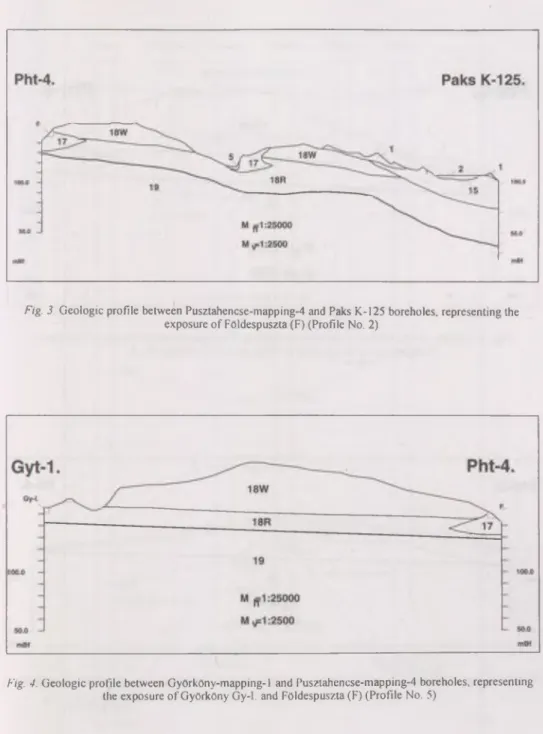
Within the loess sequence, the interrelationship between the sediment types is so occasional, and the loess formations o f different age perform so similar properties, that it is impossible to map each level, and, in the case of m inor exposures the lithological features are insufficient for dating. That is why loess sequence was represented in a uniform manner as a single element on the map. However, in the profiles, on the basis o f data and results obtained from the evaluation o f exposures, each loess presumed to be older than Wiirm was distinguished using a marking 18R, and the loess likely to be of Wiirm age was distinguished with a marking 18W (Figure 3). A formation that is in a special relation to loess is the Pleistocene drift sand found in the area. This deposit type was formed at the same time when the loess sequence. As a function o f changes in climatic conditions, loess always contains a certain amount of sand, but marked drift sand levels were only formed at some places. However, this drift sand generally has a more limited areal extent than the regional scale, and in m ost cases it wedges out horizontally. As a result, it rarely can be determined whether two drift sand occurrences distant from each other in space belong to the same bed, or not.
14
Upwards along the Paks key profile, the number of sand beds shows a decrease.
During the investigations, several concepts concerning the development of sand beds found here were formed: some researchers (Adam et al. 1954) deemed that the sand beds were of fluvial origin. Krivan (1955) considered sand horizons of eolian origin. Pecsi (1993) supposed that the most typical sand beds in the Paks exposure were formed as derasional valley fillings. On the basis of their facies the Pleistocene wind blown sands found W of Paks both in surface exposures and in boreholes cannot be clearly correlated with the sand layers found in the key profile. Had we taken into consideration, however, the climatic conditions that led to the development of drift sands, and the sedimentary conditions that had been able to supply sufficient amounts o f sediments for drift sand development, it could be made probable that the best conditions for the forming of this drift sand started to prevail near the Riss-Wiirm boundary, or in the beginning of the Wurm.
O f geological profiles compiled on the basis o f surface exposures, boreholes penetrating each sediment, and the geoelectrical logs, it is log Phsz-2 attached as an annex to the GIS, and profiles 5 and 6 (Figures 4 and 5) that show which setting position can be assumed for these rocks on the basis of data available at present. It should be noted that for a part of drift sand occurrences, only the thickness and properties of soils formed on them provide opportunities for dating.
The bedding conditions of the Pleistocene slope deposits are only rarely doubtful:
their development is likely to have taken place during the entire Pleistocene, however, in most o f the cases, as loess sequence they are represented in the form of reworked soil levels, delies, valley infillings. Only the younger talus deposits likely to have been formed during the final stage o f the Wurm were represented in the map with a separate symbol. Their position matches with the present terrain conditions and they were accumulated in a larger amount particularly at the bottom o f the terrain elements having already formed during the Pleistocene and along the valley sides. Their altitude with respect to sea level does not have relevance since it is the current base level that plays an important role in the evolution of the valleys, and its alterations also influence the emergence of slope deposits.
The topics concerning the dating and stratigraphic position of Pleistocene fluvial deposits including their relationship with deposits of other facies should considered to be problematic. Both in the exposures containing fluvial deposits and in the boreholes, the development conditions of the sediments could be relatively well assessed. However, no exposure at all could be found in the region that would allow for a precise determination of the relationship between the fluvial deposits and the loess sequence. As far as the chronology is concerned, there exist different opinions. The sporadic biostratigraphic data (Jasko and Krolopp 1991) refer, at some sites, to an Early Pleistocene origin whereas at other sites to a Late Pleistocene one. Consequently, it can be stated that in a part of the area fluvial sedimentation also took place simultaneously with loess formation during the Pleistocene. However, the lateral contact and relationship between the two facies are unknown to us. This also means that although in some cases the age of the sequence can be dated in vertical profiles, its correlation with deposits o f a different facies is difficult.
This represents a significant problem not only concerning this particular geographical area but also within the Quaternary studies in Hungary.
Based on data concerning chronology and bedding, two types o f Pleistocene fluvial deposits are distinguished. The age and classification of deposits of the Danube valley can be evaluated on a sedimentary or on a biostratigraphic basis (Jasko and Krolopp 1991).
Beds with an age and facies similar to the part assigned to the Upper Pleistocene can be found NW of Paks, in a valley stretching towards Cseresnyes and in a sequence in the row o f hills between Tengelic, Szolohegy and Pusztahencse. Beneath the latter, the Lower Pleistocene levels can also be found W of the area, in boreholes found in the vicinity of the Training Center at Tengelic.
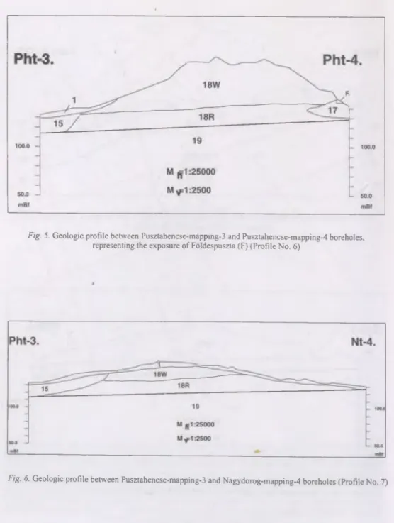
Based on the aforesaid, the solution selected in geological profiles was to represent the boundary between fluvial deposits and loess as an erosional boundary and the sedimen
tary terrains of fluvial deposits were represented as erosional troughs that partly existed earlier (Figure 6).
On the surface of the Pleistocene fluvial sand, the conditions of drift sand develop
ment were created at several places due to a change in the climatic factors. At those parts of the area where Pleistocene drift sand overlies the fluvial sand, generally the two facies cannot be separated sharply. In many cases, sand dunes of material blown out from a relatively small distance are found in the area. As a function o f changes in the wind intensity and the paleomorphological conditions, at some places blow-outs are found, whereas at other sites larger dunes were built by the wind. This situation also allowed small lakes to form at the end of the Pleistocene. The relation between Pleistocene fluvio-eolian sand and Pleistocene drift sand*is still not clear. They have a similar m ineralogical composition, thus the blow-out terrain level and the place of origin o f the original deposit may be the same for both sequences, however, their regional extents show some differences. It is not excluded that the two deposits may be of the same age but there is no direct evidence to it, and no deposits overlying the fluvio-eolian sand and indicating new inundations by the river have been found either.
In the whole area, there is an unconformity between the Pleistocene and Holocene deposits. Even in the areas where the sedimentary conditions were similar during the two periods (such as near the Danube), there is a hiatus between the facies, thus there is no continuous transition between the Pleistocene fluvial deposits and Holocene fluvial depo
sits.
Among the Holocene deposits, the fluvial deposits are considered to be the oldest.
In the area they occur at several levels, in the form of channel and flood plain deposits alike. Their interrelationships and the changes in granulometric composition are determi
ned mainly by phenomena associated with water streaming and water level fluctuation.
The only usable order as to the age o f deposits of different grain size can be set up in that bed deposits in the area W of river Danube are older than the flood plain deposits also found here, whereas in the vicinity o f the present bed, the youngest ones are, of course, represented by the bed deposits.
The Holocene sedimentation is characterized by a relatively quickly changing facies and limited horizontal and vertical extents. In the vicinity o f the Danube, due to the development of the flood plain, generally, at the bottom the bed deposits, then flood plain deposits are found. Overlying them fluvial-paludal sediments deposited in the small
16
remaining lakes, under stagnant water environment are found. In local sedimentary basins, farer from the Danube, limnic deposits were formed. For the whole area is typical, that the older deposits are covered by a relatively thin Holocene drift sand in a significant regional extent. The underlying bed outcrops partly in small spots, partly regionally. It is typical that wind acts as a destructive rather than a accumulative element on hill ridges exposed to it the most. At these sites, drift sand is only rarely found, and blow-outs are rather typical.
The sediments formed due to an anthropogenic activity not represented in the map but yet supplying a significant amount of deposits should also be notec}. Even disregarding any activities resulting in deposits differing from those described before indirectly, due to a transformation o f the environment (for instance, the damming of fish ponds), youngest Holocene deposits are found over a large area and, at some places, in a considerable thickness. For the deposits resulting from human activities, two significant types can be distinguished: one o f them is a reworked rock of geological formations, considerable rock masses of former periods, such as the backfill that was used to provide a foundation for the Nuclear Power Plant and that attained, at some places, a thickness of 2 m, and the other one is the accumulation o f wastes, by-products resulting from human activities. Unfortu
nately, its thickness, in the area concerned, also attains several meters at some sites, and not only in officially established, controlled waste disposal areas but also in the illegal waste disposal sites.
3. B orehole survey
The first boreholes were deepened to support the geological mapping of the area , around the Paks NPP in 1985. In relation to the geological mapping o f an approximately 720 m2 large area, 20 mapping coring boreholes of 30 m depth, and 99 shallow boreholes o f 10 m depth were deepened around the NPP, all of them on the west bank o f the Danube.
The boreholes were aimed at complementing the mapping, and helped to solve the stratigraphical and facies problems having arisen during the field survey. Part of this material were subject to laboratory tests (Chikan et al. 1985, Chikan et al. 1986).
Out of the boreholes only 9 transversed the Quaternary formations, and all o f these stopped in the Toronyi Formations o f the Transdanubia Main Group. The petrological development o f the Pannonian formations are typical: there were found partly sequences characterized by prevailing sand, partly alternating sand, silt, clay and marl; in some cases the Ostracoda fauna confirmed the Upper Pannonian age of the formations.
By evaluating the sequences exposed by shallow and mapping boreholes, a signi
ficantly more accurate picture could be presented about the distribution of the formations, and about their relationship.
In connection to the examinations concerning seismic safety, 4 all along coring boreholes and a coring borehole between 150-300 m were deepened in 1986, in the immediate surroundings o f the Power Plant. It was M A FI’s task to analyze and evaluate the borehole data in detail. The Paks-2/a borehole was deepened on the region of the NPP,
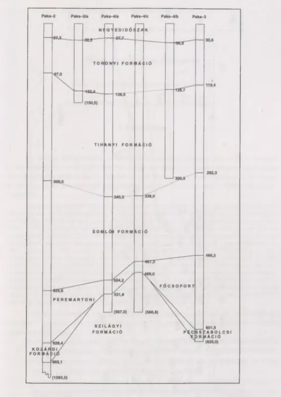
the Paks 3 borehole northeast to Dunaszentgyorgy, the Paks 4/a and 4/b boreholes were deepened southwest to the NPP. The evaluation o f the Paks 4/c borehole deepened in the immediate neighbourhood of the last two boreholes was carried out by the staff of the National Geological Research and Drilling Company (Miskolc). The formation groups transversed in the boreholes could be correlated easily (Figure 7).
The detailed evaluation of the deep boreholes brought numerous new results, both in describing the geological formations found near to the Pow er Plant, in clarifying their stratigraphical position, both in relation to the structural-geological information about the region. The detailed reports about the boreholes (Chikan 1986, Chikan et al. 1987a, b contain all the basic data produced during the evaluation, and the attached explanations as well. In the present essay emphasis was put only on the m ost important elements o f the geological results.
Stratigraphically it is important, that the earlier known, Szilagyi Claymarl Forma
tions o f Badenian age, which were transversed by the Paks-2 borehole deepened in 1979 in the region o f the Power Plant (Jambor et al. 1982), was also reached in two boreholes set southwest to the power plant, in the Paks-4/a and in the Paks-4/c ones. But the Badenian Formations were reached in the Paks-3 borehole, in the form o f another facies, namely the Leitha limestone sequences to be correlated with the Pecsszabolcs Formation. At the same time, the Sarmatian formations ovelying the Badenian ones reached in the Paks-2 borehole were missing from all of the further boreholes partly due to their washing away (Paks-3), partly for structural reasons (Paks-4/a, 4/c). Consequently the Lower Pannonian formations settle discordantly on the underlying bed in all the three boreholes reaching the Badenian.
Being of average basin nature petrologically development are, they contain alternating claymarl silt and silty claymarl. The Paks-4/c borehole transversed the Upper Pannonian Formations with full segment, in the other boreholes the sediment sequence of average basin facies can be characterized by well comparable data, which is formed by the series within the Somloi, Tihanyi, and Toronyi Formations. The thickness and the distribution pattern of the three formations is varied according to bottom configuration and flow patterns of the former Pannonian inland lake, and depending on the coast distance and the nature of the transported clastic material; in some places they tend to grow or to diminish at the expense o f each other. In some places, for example near to the NPP, the geophysical measures and the borehole data equally showed, that the formation was affected by structural movements. One possible interpretation of the tectonic phenomena exposed here is shown in Figure 8.
In all cases there is a significant hiatus between the«Pleistocene formations supe
rimposing the Upper Pannonian formations discordantly and the underlying bed, but the thickness o f the sediment missing cannot be established exactly. The Quaternary formati
ons in all o f the three boreholes consist of Danube sediment mainly, with the exception of the Paks-4/b borehole, where under the Danube sandy pebble, ancient silt sediment of loess origin is found between 31,8-36,9 m.
From the structural-geological point o f view, the Paks-4/a and the Paks-4/c bore
holes brought new results. In the two boreholes settled on the flower-structures outlined on an earlier measured seismic section on the region, a tectonic zone was exposed indicating a considerable displacement between the Lower Pannonian and the Badenian
18
layers. Furthermore, in the whole borehole succession faults, or joints were identified in a downward increasing quantity, referring to tectonic effects. Fault-scratches were observed on a significant part of joints, which are of relatively flat dip and, as a consequence, they refer to a displacement with a considerable horizontal component.
4. A rtificial exposures
In the course o f investigations carried out in the environs of the NPP, the age of the presumed or rather, observable structural phenomena was coming to the fore gradually.
The fundamental question, whether the structural phenomena exposed by seismic m easu
rements and boreholes had been renewed during the Quaternary or not, was to be solved by the application o f several methods. The analyses o f the joints measured in the natural exposures (Chikan and Kokai 1989) have not yielded convincing results. Because of this, after a significant geophysical preparation (Mesko et al. 1993) a trenching research was executed in the region, in the framework of which along a section of 500 running metre length, qualified as a zone o f disturbance by the geophysical measurements, trenches were deepened down to an average 2 m, and documented in detail (Don et al. 1992, Chikan and Jedlovszky et al. 1992). These experiments proved, that tectonic, structural phenomena affecting the surface cannot be identified on the section qualified as a zone of disturbance by the geophysical measurements. At the same time the data referring to the stratigraphic conditions o f the formations studied in the course of the trenching could be used when the geological map was constructed.
To the stratigraphical analyses and paleogeographical reconstruction of the region’s Quaternary formations, and to the final evaluation of the geological-geophysical-geomorp- hological data received in the course o f the geological works carried out in the neighbour
hood of the Power Plant in 1994, supplementary examinations were necessitated in order to get to know the basic characteristics of the most typical Quaternary formations in the region in more details, their interrelationship, and to provide a more accurate dating and history of evolution.
To attain this goal, 10 groups of formation of the earlier investigated exposures were chosen, exposing the widest spread layer groups in the region, and their detailed palaeont- hological and sedimentological examinations had been carried out. For the sake of the later evaluation and comprehensive examinations an artificial exposure was created for com pa
rative studies, which was established at the place o f a landslide of the Danube bank having occurred in January 1994, at Dunafoldvar. During data processing, the sequences o f the exposures were described from the top, and - in order to be able to compare it with the section of the Paks brickyard - a downward sampling was executed with a frequency of 20 cm.
The results o f the completed evaluations were summarized in two reports (Chikan et al. 1994b, Kokai et al. 1994). These reports contain the detailed data and examination results of the analyses by the individual exposures. The present essay focusses on the most relevant results used for the synthesis of the formations and the construction of the geological map.
From our artificial exposures we had received data regarding age from the exposu
res signed Gy-I, Gy-II and T-3 These formations have proven to be presence older than Wiirm, i.e. they represent M iddle Pleistocene loess formations. The loess found in exposure T -l proved to be the oldest of them, where the fauna indicated an age older than Wiirm, but the palaeomagnetic measurements and paleosol properties made the presence of the double soil o f Paks presumable. The surface distribution of this group of formation cannnot be mapped because of the relatively minorlithological differences. In the loess sequence o f the Gy-I and Gy-II exposures a younger fauna, still older than Wiirm, i.e. of Riss or rather Riss-Wiirm age could be identified, and the paleosol exposed here corresponds partly to the M ende Base, partly to the Basaharc soil complex. Loess formations found higher in the profile fully correspond to Wiirm; the youngest loess formations also can be found in the western area of the region, near Gyorkony: in our opinion, the sandy loess o f the Magas-hegy o f Gyorkony is the youngest loess horizon o f the whole area, probably even younger, than that on the top o f the section of the Paks brickyard.
As it has already been mentioned the age of the Pleistocene quicksand is uncertain at some places. The exposure T-2 and T-4 of Tengelic are exam ples, where neither the relationship of the Pleistocene quicksand to the loess can be determined, nor it contains faunasuitable for dating, therefore its ranging is based on the thickness and characteristics of the recent soil developed on it.
The Pleistocene fluvial sand formations are partly of Early-, partly Late Pleistocene age. The Paks-I, Paks-II, and Tengelic-2 artificial exposures showed younger fluvial sand.
A somewhat differing evolution and stratigraphic position is documented by the Gy-III exposure at Gyorkony, which settles higher, than the previous formation group, with Pleistocene quicksand and loess on it; therefore it is possible, that this also represents the older part o f the Pleistocene. The horizontal development of this formation is not known.
The fluvial layers observed in the exposure probably indicate the alluvial fan sediment depositedbetween the older and the younger loess series.
5. Synthesis of the geological fo rm atio n s
Summarizing the statements and results o f the abovestudies, a synthesis of the region’s surface and subsurface formations was completed in 1994 (Chikan et al. 1994a).
This is partly summarized by the explanatory notes complem enting the information available about the surface formations found in the immediate neighbourhood of the Paks NPP, at some places with references to materials systematized in earlier reports. It also publishes a reduced version of the region’s geological map o f 1:25,000 scale, and describes the spatial relationship o f the individual formations to each other in numerous sections.
The introduced geological map became part of the space information database containing geological data about the region, as the basic map representing the geology o f the region.
20
6. G IS d atab ase
In the course of the summary and analysis of geological information about the N PP’s surroundings o f 10 km radius a wealth of data of different content and resolution accumulated. The handling, structuring and effective operation of this data set need precise work in informatics and powerful software-hardware environment. Adaptation of the spatial data to GIS seemed to be logical. GIS plays a significant integrating role, as place is a natural connecting point for every (not only geoscientific) subtopic. The organizing of GIS database makes it possible, that autonomic information can be integrated, the necessary parergon o f which is homogeneous and standardized database content. With the help of the database the cognition of complete information series is possible at the points within the examined area, also to determine logical filters including different subsets of the topics and to represent the results on maps.
According to the given tasks basic and concluded graphic and describing data of fixed topics, prepared by different research institutions (MAFI, ELGI projects and divisi
ons), have been adapted to the GIS. The accomplishment occurred in Intergraph MGE environment. Below the principles and the description o f the system is reviewed. The text refers to the documentation of used standard Intergraph applications, the explanations below only contain the absolutely indispensable information.
The p rinciples o f developing the database w ere as follows:
The data series are fitted into the M G E environm ent o f Intergraph, therefore the database (its graphic and alphanum eric part) follow s the M G E standard.
The data structure and data types ensure full com patibility to other Intergraph modules and applications.
The graphics does not use such m odules (arc, curve, B-spline), which might cause problem s when running other m odules. The alphanum eric tables contain data fields built from basic types (char, integer, real). This ensures the openness o f the data series in a w ider sense.
The data are m axim ally classified. C lassification is one o f the m ost im portant elem ents o f the GIS * database. This m akes the widest range application and representation possible. Every object represented on the map can be reached both autonom ically and according to its logical status. T he objects are separated according to LEVEL in the graphics, and according to their identification or characteristics in the database tables. In other words: every object that can be represented on m ap is separate either graphically or alphanum erically (record linked to graphic elem ent).
Digital maps reflect database approach. This m eans that the form ing o f m ap-intelligence alw ays supervises the cartographic view points. In other words: the main task o f the graphic elem ent is the expression o f spatiality and not the traditional delineation according to key definition. The inform ation needed for cartography is ensured by the classification and the linked database inform ation.
A m ajor view point is to accom plish a m ultipurpose system and to avoid redundancy.
It was attem pted to reach identification m inim um at every topic o f the database. This m eans that the minimal dem and concerning the database inform ation linked to graphic elem ents is the record o f unique or type identification. By using this as key field, the data table can be related to any describing data. The database functions as basic data collection in its current condition, but it is also prepared for answ ering com bined questions.
The M G E data m odel ensures the hierarchic classification and grouping o f the inform ation. The highest unit o f the model is the PRO JECT. The P R O JE C T is the totality o f maps, alphanum eric data and data type definitions. T he next level is the totality o f m aps which are included in INDEX. T he maps are part o f different
them atic groups (CATEGORY). O ne m ap can only belong to one category. M aps can be defined as graphic representation o f the objects o f the real w orld. E very graphic unit belongs to one determ ined FEATU RE class.
The FEA T U R E is the totality o f the object’s further undividable characteristics.
The highest level classification form in the hierarchy is INDEX. A lthough the basic data series is supported by traditional profiles, there are continuous maps appearing in the database. So the aim o f using INDEX is not to edit a virtual continuous map, but to install feature com binations o f m aster-reference files.
A ll them atics have been ordered in a so called paks 10 category. The categorization does not mean that we have to give up classification; it happens on the F EA TU RE level. The m ain reason for that is that nothing justifies the strict separation o f the them atics on C A TEG O R Y level. The sole pakslO CA TEG O RY can be inaugurated to further M G E m odules w ithout any restrictions.
T he topics are equally classified on F EATU RE-ATTRIBU TU M level. The logical hom ogeneity o f FEA T U R E can be tracked based on the term inology.
T here is a determ ined softw are and hardw are environm ent belonging to operating the GIS database, and the reference system also belongs to its build-up and usage as m ain characteristic. The softw are environm ent is represented by Intergraph MGE. The M G E environm ent is the totality o f m any different but coordinated and connected with each other softw ares. The tw o separate parts o f the database are the graphic and alphanum eric data series, in other words the maps and the describing data connected to the m ap elem ents. At first approach graphic data are processed by M icroStation, alphanum eric ones are processed by an RD BM S (in our case ORA CLE). T hese basic softw ares support m ore application groups and modules. To handle the database o f the surroundings o f the N PP o f 10 km radius the follow ing m odules are necessary:
M icroStation
M G E Basic Adm inistrator M G E Basic Nucleus M G E Base M apper MGA Analyst M SM Terrain M odeller RIS-RD B M S (O racle)
The recording, editing and representation o f digital data is the task o f M icroStation. Alphanum eric data manipulation is carried out by RIS/ORACLE. RIS is a surface betw een Intergraph m odules and the database processors which ensures the independence o f the database. In other w ords the user meets only RIS when processing alphanum eric data, and does not even need to know , w hat the concrete database processor tool is.
M G E modules carry out database adm inistration, cleaning o f contours, connection keeping with RD BM S and basic queries. Database adm inistration is a planning procedure before filling up the system with data. The classification, definition and recording o f the graphic and alphanum eric data structure is the plan o f the GIS. One o f the tasks o f this docum ent is to publish and explain the adm inistrated records. T he MG A module is responsible for creating topology, and carries out topologic queries and representations. T he M SM m odule creates, queries and represents digital relief map.
The hardw are environm ent is determ ined by partly the used softw ares, partly the dem ands o f the handled m apping and num eric data series. The developing tool is Intergraph C lipper based W orkstation (InterPro 2700).
The operation system is unix (clix). T he necessary storing space (considering only data) is 40 Mb, the memory need is m inim um 64 Mb.
The GIS data series o f the surroundings o f Paks o f 10 km radius is built on E O V reference system, this includes 24 profiles. The resolution o f the reference system is 1:10,000. Tfie them atic maps w ere edited on the 1:10,000 base, but their resolution is different. The unit o f m easure o f the coordinates included in the system is metre.
M apping them atic is the determ ining and key factor, holder o f the database connection in the GIS. Most o f the graphic elem ents constituting the m ap plays an im portant role in inform ation supply beside the represen
tation o f the real world. The inform ation connection is built on the relations betw een database tables and on topology. T he system only answ ers questions w hich are able to be concluded and calculated from the built-in inform ation (MGA). The w ording o f the questions is the user’s task. Som e technical data o f the m ajor m apping them atics are described below.
Topography was digitized by profiles o f 1:10,000 scale. W ith regard to the fact, that this is the most com plex them atic, separate digitizing rules and handling tools w ere set up, the present description refers to these cardinal points. The follow ing objects and graphic elem ent types can be separated on the topographic map:
22
-lin e a r elem ents, -are as, -p o in t elem ents, -inscriptions.
T he lined elem ents are in m ost cases boundaries o f areas (branch o f cultivation, vegetation). A ccording to cartographic rules only the one o f highest priority appears in case o f m atching lines. The digitizing technology follow ed this principle. But to m eet both the representation and the GIS dem ands, every line-section (from one crossing to the other) is an autonom ic graphic elem ent, with a describing note linked to it (attribute record). This note m akes the enum eration o f every function concerning one line section possible. If e.g. there is a road on the boundary o f a forest and a ploughland, then the road (linear fea tu re ) covers the vegetation boundary (area boundary fea tu re ) according to priority. Both functions o f this section is noted in the database. The elem ents o f the topographic maps are not up-to-date, they reflect conditions from 1979. A ccording to agreem ent the full scale process of this condition would be an unnecessary investm ent and false. Therefore we can qualify the topographic base as follows:
- i t reflects the present situation,
- its database intelligence is on graphic elem ent level,
-to p o lo g ic intelligence (interrelationship o f graphic elem ents, qualification o f regional elem ents accor
ding to branch o f cultivation, vegetation) is prepared, but its accom plishm ent is only reasonable after updating based on air-photos,
- th e linear structure o f the topographic system is suitable for orientation, it is the base o f professional thematics.
T he base o f the digital elevation m odel is the vertical contour draw ing o f the topographic map. In order to be able to handle data only each tenth contour w as digitized. At places where the preciseness o f morphology m ade it necessary, the bisecting contour was digitalized also. The contour draw ing has A TTRIBUTUM , ”Z ” value was ordered to every line. This linear structure is the base for the m odeling m odule (MSM). T he area E o f the Danube with elevations o f9 0 m a .s .l. can practically be considered as flat. This area is registered as constant level (PLANAR AREA). T he deep valleys, quays, m ainly bordered by abrupt loess walls are marked w ith separate auxiliary lines. T hese auxiliary lines m odify m odeling and make it m ore precise. A part o f the relief map are numerous spots elevation, w hich also serve to improve the model.
Boreholes can be found in tw o logically linked tables. The prim ary table contains global data concerning the borehole, such as the prim ary key field and the identification o f the borehole. The sequence table contains the transversed geological units and their underside depths. T he prim ary table contains the m easured coordinates o f the boreholes and the ones that w as edited on th e layout. The borehole-point m ap can be generated from the database table. The appearing text at the borehole point can be any inform ation o f the primary table in the graphics.
T he so called F T V boreholes exposed the settlem ent o f the NPP. The database was m ade by the FTV Rt. inM icroStation-dB ase form at. The structure of the database is created in prim ary table-sequence table system.
The available data w ere converted to M G E environm ent. No changes has been made to the original data, new columns w ere inserted to identify boreholes and EOV coordinates.
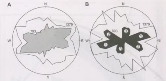
T he observation m ap records the spatial position and form o f the observation spots. T he extension o f the observation is often m inim al, point-like. In this case a little square sym bolizes the shape o f the exposure in order to m ake unified handling possible. A lot o f inform ation connect to the observation place: tectonic measurem ents, layout plan and description with text. T heir representation is carried out with the help o f an external order, it can be defined as sim ilar to shallow boreholes concerning their data structure. At the observation point the identification o f the exposure and the exposed rocks are enum erated. As a com pletion, layout, stereogram , rose diagram and grain dispersion graphs belong to the text. T hese partial data are not parts o f the actively accessible database, but the basic inform ation can be introduced to reach the elem ent. The operating tool o f this function is not part o f the standard M G E applications, it is an external M D L developm ent.
T he geological m ap represents the form ations found in the area and the lines o f the edited profiles. The types o f geological form ations w ere separated according to age, genesis and com position by num eric codes in the table attached to the map. An intelligent map was created with the help o f the topology generating m odule o f the M GA application, in w hich th e m entioned types can be accessed one by one or together based on abbreviated them atic identifications given in the linked table. W e edited a colour map by using topologic data structure, the key o f w hich is conform to the generally accepted colour types o f geologic maps. Identifications o f the geologic profiles belonging to the geologic m ap are stored in a separate table, connected to each other by profile lines. The