Groundwater for Sustainable Development 11 (2020) 100408
Available online 7 May 2020
2352-801X/© 2020 The Authors. Published by Elsevier B.V. This is an open access article under the CC BY license (http://creativecommons.org/licenses/by/4.0/).
Research paper
Hydrogeological framework of the volcanic aquifers and groundwater quality in Dangila Town and the surrounding area, Northwest Ethiopia
Mulugeta C. Fenta
a,b,*, Zelalem L. Anteneh
b, J � anos Szanyi
a, David Walker
c,daUniversity of Szeged, Department of Mineralogy, Geochemistry and Petrology, Egyetem Street 2, 6722, Szeged, Hungary
bBahir Dar University, School of Earth Sciences, P.O.Box 79, Bahir Dar, Ethiopia
cNewcastle University, School of Engineering, Newcastle Upon Tyne, UK
dKyushu University, Faculty of Design, Fukuoka, Japan
A R T I C L E I N F O Keywords:
Volcanic aquifer Groundwater quality Fractured rock Ethiopia
A B S T R A C T
Volcanic aquifers are sources of groundwater for both urban and rural areas. Their occurrence in geological formations and water quality are the main issues for sustainable utilisation. Dangila town and its surrounding area, northwest Ethiopia, is assessed for hydrogeological framework and groundwater quality based on well and hydrochemical data. The study showed that the area has a multi-aquifer system: an unconfined perched aquifer at shallow depth and; semi-confined and confined aquifers at greater depth in Quaternary basalts.
The aquifer has five groundwater facies: Ca-HCO3, Ca-Mg-HCO3, Ca-Na-HCO3, Na- Ca-HCO3 and Na-HCO3. The Ca-HCO3 groundwater types are dominant in the shallow unconfined aquifer system, and the Na- Ca-HCO3 and Na-HCO3 types are dominant in deep aquifer systems. Mixing of waters from shallow and deep aquifer systems is minimal and possible only through interconnected fractures. Groundwater storage and flow is controlled by intensity and interconnection of fractures. Hydraulic conductivity is higher for fracture dominant aquifers than weathered rock aquifers. The groundwater chemistry is mainly controlled by rock weathering and cation exchange. Groundwater quality assessment shows that water from both aquifer sources is potable. Based on sodium adsorption ratio (SAR) and residual sodium carbonate (RSC) values, all groundwater schemes are in the excellent quality class and can be used for irrigation without any problem. However, high Naþin borehole samples restrict the deep groundwater suitability for irrigation use without adjustment. The combined results of the study are used to construct a hydrogeological conceptual model of volcanic aquifers, which can be used to manage the groundwater resource for sustainable development. This study would be helpful for water resources management in other similar geological settings.
1. Introduction
Volcanic aquifers are vital, and sometimes the only, sources of groundwater in many regions of the world. They are stored in volcanic rocks that are considered as minor in areal coverage of continental crust compared to other rock types. The proportion of volcanic rocks exposed on continents totals only 6.8–8% of all the rock types of the earth (Blatt and Jones, 1975; Meybeck, 1987; Suchet et al., 2003). Among these extrusive rocks, 36% of the total is found between 0�and 30�N, mainly in the Deccan Traps in India, and in Ethiopia (Suchet et al., 2003). They occupy only 6% of the land area of sub-Saharan Africa and are mostly confined to east Africa (MacDonald et al., 2008).
In numerous countries all over the world, including Ethiopia,
groundwater is obtained from volcanic aquifers that are stored in the fractured and weathered parts of volcanic rocks. Groundwater provides more than 90% of the freshwater used for domestic and industrial supply in Ethiopia (Kebede et al., 2018) and is dominantly abstracted from volcanic aquifers. Its occurrence varies spatially owing to complexities of regional and local geology and associated geological structures. Since surface waters are becoming increasingly unreliable due to climate change and pollution, understanding the groundwater system is essen- tial. Previous research on volcanic aquifers focussed mainly on oceanic islands (Join et al., 2005; Prada et al., 2005; Pryet et al., 2012; Violette et al., 2014). In contrast to Islandic basaltic volcanism, the predominant action of rifting and jointing generally generate more significant litho- logical variety, giving rise to very high lateral and vertical variability of
* Corresponding author. University of Szeged, Department of Mineralogy, Geochemistry and Petrology, Egyetem Street 2, 6722, Szeged, Hungary.
E-mail address: mulugeta@geo.u-szeged.hu (M.C. Fenta).
Contents lists available at ScienceDirect
Groundwater for Sustainable Development
journal homepage: http://www.elsevier.com/locate/gsd
https://doi.org/10.1016/j.gsd.2020.100408
Received 10 January 2020; Received in revised form 27 April 2020; Accepted 3 May 2020
the structure and the hydrodynamic properties of aquifers. There has been very little research on continental rift or faulted volcanic aquifers in Ethiopia (Aberra, 1990; Ayenew et al., 2008; Vernier, 1993). Owing to the complexity of volcanic rocks, the inadequacy of data and limited previous research, the hydrogeology of the area is barely understood.
Hydrogeological prospecting can be problematic in volcanic rocks, especially in the rift and faulted volcanic areas, and groundwater re- sources are not easily exploited. Several programs were conducted by different sectors to alleviate the scarcity of drinking water in Dangila town and surrounding area over the past 44 years (1973–2017). Spring developments, drilling of shallow hand-dug wells and deep boreholes of 58–209 m depth were among the leading programmes. Despite these programmes, only a few (3 out of ten boreholes) have groundwater yield of 18–30 L/s while others have less than 3.5 L/s and became dry or were abandoned after drilling. There are reports of yield reduction of these boreholes over time, and most of the springs and shallow wells have meagre groundwater yield (<1L/sec).
The significant dependency of the urban and rural population on groundwater as primary drinking water source, and the recent increases in industrial and irrigation uses requires a better understanding of the groundwater system. The exponential growth of the urban population and agricultural led industrial development policies of Ethiopia attracts greater attention of researchers to groundwater as the potentially cost- effective water supply source. The country has implemented groundwater-based irrigation projects utilizing more than 9000 bore- holes, 28,000 monitoring wells and 14,657 spring improvements and achieved 10% GDP growth during the last two decades (Mengistu et al., 2019). The countrywide pilot-scale irrigation practices are to be inten- sified soon, and there are several small-scale irrigation schemes in the study area. Despite this expansion of groundwater use for irrigation, the suitability, quality and future effects of the groundwater on agricultural soils are not well studied. Therefore, this research aimed to assess the
quality and suitability of the groundwater for irrigation.
The existing deep boreholes, shallow wells and springs provide several information about the hydrogeological framework and ground- water quality of the area. Therefore, the study aimed to fill the research gap concerning faulted or rifted volcanic aquifers using well information and hydrochemistry data. The lack of integrated research in volcanic basaltic continental contexts justified the necessity of more in-depth characterization of the hydrogeological functioning of the area. Thus, the research aimed to develop a hydrogeological conceptual model of the structure and functioning of a volcanic aquifer system situated in a vast continental rifted context.
1.1. General description of the study area
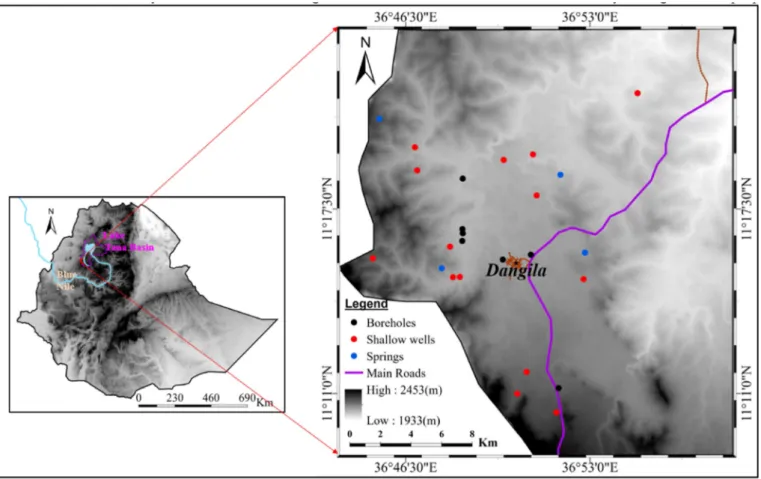
The study area is located at Dangila district, known in Ethiopia as a woreda, in northwest Ethiopia (Fig. 1). Physiographically, the area is found at the southern part of Lake Tana basin. Dangila town and its surrounding areas have a mean annual rainfall of 1640 mm, as measured (since 1988) at the National Meteorology Agency (NMA) weather station at Dangila, 91% of which falls from May to October (Walker et al., 2019a). The average annual precipitation across the whole country of Ethiopia is 817 mm/year (Fazzini et al., 2015). The climate of the area is moist subtropical with a median annual daily maximum temperature of 25 �C and minimum of 9 �C, as measured at the NMA weather station in Dangila (Walker et al., 2016). The mean annual temperature of the country varies from over 25 �C in the hot lowlands to less than 7–12 �C in the high altitude plateau (FAO, 2016). Dangila woreda that contains the study area has an area of approximately 900 km2 and a population of around 160,000, of which 132,000 are rural and the remaining 28,000 dominantly reside within Dangila town (CSA, 2012).The elevation of the area ranges from 1933 to 2453 m with seasonally inundated large floodplains used as pasture and low hills comprising rain fed cultivation.
Fig. 1. Location map of the study area.
Groundwater of the study area is used for drinking, household, indus- trial and small-scale “backyard” agricultural purposes.
1.2. Geological setting
Two main types of volcanic rocks cover the region of Lake Tana basin with a considerable thickness. They are defined by their age and are known as the Tertiary or Trap series and the Quaternary or Aden series (Mohr, 1963). Tertiary volcanic rocks (Trap series) mainly cover the area surrounding Lake Tana, and the Quaternary volcanic rocks (Aden series) comprise the area to the south of Lake Tana overlying the older Tertiary volcanics. The Tertiary volcanic rocks of the basin are not exposed in the study area as they are covered by Quaternary volcanics, comprising basaltic lava flows, scoria and their weathering products as regolith and clay soil. The Quaternary volcanics of the area are greater than 210 m in thickness, as observed in borehole logs (Fig. 2), and they provide outstanding groundwater reserves. Structurally, the basin has experienced at least three phases of deformation. The earliest recog- nizable deformation features NE-SW trending regional gneissic foliation and schistosity followed by NE-SW trending compressive stress-producing micro-folds having NW-SE trending axial trace. The last and recent regional deformation event created low-angle brittle frac- ture, representing right-lateral strike-slip fault (Beshawered et al., 2010). A study by Sogreah and Geomatrix (2013) grouped faults in the basin into four distinct sets of linear features trending in NE-SW, NW-SE, N-S and rarely E-W directions. These deformations interlinked with the timing of volcanic eruption events form a complex aquifer system at the study site.
2. Materials and method
2.1. Rock samples and borehole lithology
Quaternary rock outcrop samples from two locations were analysed at the University of Szeged Mineralogy, Geochemistry and Petrology
Laboratory for mineralogical composition and rock structure at micro- scopic scale. Standard rock sample thin sections were prepared and analysed using Ore and Raman microscopes. Lithological data of bore- holes and shallow wells in the area were collected from borehole drilling companies to construct geological sections and support geological maps.
2.2. Water samples
A total of 14 shallow well, two deep borehole and four spring water samples were collected during the dry seasons (February to April) in 2015 and 2017. The samples were analysed for physical and chemical parameters in Amhara Water Works Design and Supervision Enterprise laboratory, Ethiopia. Physical and chemical parameters comprising pH, electrical conductivity (EC), total dissolved solids (TDS), cations (Ca2þ, Mg2þ, Naþ, Kþ, Mn2þ, Fe2þ) and anions (Cl , SO42þ, HCO3, CO32 , NO3, F and B ) were measured. The portable multiparameter measuring instrument, Hanna HI 991301 was used in the field to measure pH, EC and TDS. In the laboratory, atomic absorption spectroscopy was used to measure cations, palintest photometer 7100 employing the colorimetry method was used for anions, and alternatively titration for carbonate and bicarbonate measurements. Physical and chemical data from five boreholes were collected from the borehole drilling companies. The drilling companies collected three samples at the beginning, middle, and end of each pumping test (during 24, 48 and 72 h tests, depending on the specification) to assess hydrochemistry variations of near and distant aquifers. The physical water parameters, pH, EC and TDS, were measured in both the field and the laboratory.
2.3. Pumping test
Step and constant rate pumping tests were conducted for boreholes at the end of drilling before well construction. Step tests consisted of four steps with each step having a duration of 1–2 h with ¼ to 1 L/s times the expected yield of the boreholes. Subsequently, the boreholes were tested for 24, 48 or 72 h with constant yield depending on the specification.
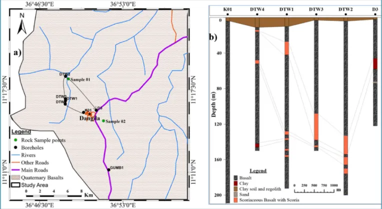
Fig. 2. Geological map of the study area (a) and simplified cross-section K01-D3 from boreholes (b).
Pumping test data of four selected boreholes was analysed using the Moench fracture flow model (Moench, 1984) to estimate the aquifer hydraulic parameters. It is not common practice to conduct tests following completion of drilling works of shallow wells in Ethiopia.
Therefore, hydraulic parameters of 5 shallow wells in the area are inferred from previous research.
2.4. Hydrogeological conceptual model
Existing conceptual hydrogeological models of volcanic aquifers, the Hawaiian model (McDonald et al., 1983), the Canary Islands model (Custodio, 1989) and the Mayotte model (Lachassagne et al., 2014), were used as benchmarks to construct Dangila area’s hydrogeological conceptual model. These Islandic volcanic aquifer hydrogeological conceptual models do not resemble the rifted or faulted continental aquifers systems. Therefore, a new model was developed that can consider the real situation of the area integrating our research by combining information from boreholes, pumping tests, hydrochemistry and other sources.
3. Results and discussion
3.1. Properties of quaternary volcanic aquifer reservoirs
The occurrence of groundwater, and consequently developing the groundwater resource primarily depends on the aquifer’s current and historic properties together with rainfall and geomorphological factors.
The volcanic rocks extending from the surface to 210 m depth consist of Quaternary basalt, scoria, scoriaceous basalt, and their weathering products as soil and regolith. The basalt locally varies laterally and with depth in both mineralogical composition, degree of weathering, frac- turing, the density of vesicles and the amount of secondary minerals that fill the vesicles. The thickness and depth of these layers varies
considerably across the boreholes in the area. These variations showed that the area had experienced several periods of eruptions from different sources, directions and timing. It exposed the upper layer for surface weathering before being overlain by younger basaltic lava flows, scoriaceous flows, and scoria falls.
The boreholes’ rock and soil samples collected at 2 m intervals and occasionally every metre whenever lithology changes were observed, comprised the following: 75.5% vesicular to aphanitic basalt lava flows, 7% scoriaceous basaltic lava flow, 6.5% scoria falls, 7.7% clay soil and regolith originating from both erosion and transport of volcanic rocks.
The alluvial sediment constitutes 1.6%, ash with clay 7.7%, sand 0.15%, and pyroclastics 1.8% of the total collected and recorded samples (Fig. 2). In all existing boreholes, the upper bedrock below clay soil and regolith comprises basaltic lava flows followed by alternating rock layers. In most cases, the scoria and scoriaceous basalt are weathered and at some boreholes (D3 and DTW4) are altered to clays.
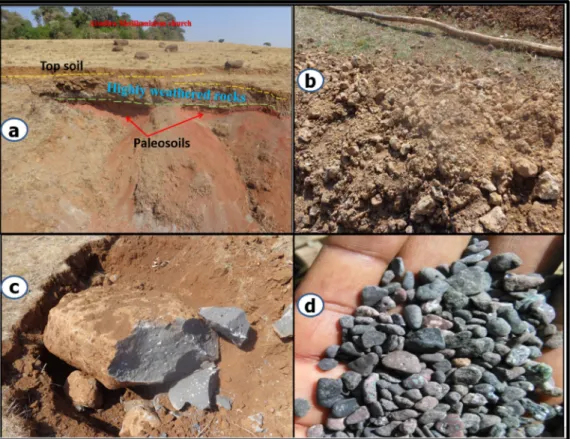
The crystalline lava consists of hard, dense basalt of light to dark grey colour. Basalt outcrops are vesicular, and in some cases, the vesicles are filled with secondary minerals (Fig. 3), mainly calcite and occasional zeolite creating amygdaloidal texture due to hydrothermal activities.
The calcite filling is highly weathered on surface outcrops but is easily observable in the subsurface where the soil has been excavated for road construction (Fig. 3c). At some localities, secondary minerals are not observed in the vesicles, but in other places, the vesicular basalts together with their secondary minerals filling the vesicles are observed up to 140 m depth in borehole lithologies (Fig. 3d).
Fractures, occurring at the top and bottom of lava flows associated with paleosols, and joints both provide groundwater flow pathways.
Weathered zones in rocks can be suitable aquifers unless they are dominated by secondary clay products (Hencher and Mcnicholl, 1995).
Basalts are easily weathered compared to other crystalline silicate rocks (Suchet and Probst, 1993) though it depends on the cumulative effect of runoff and temperature (White and Blum, 1995). The higher weathering
Fig. 3.Photographs of topsoil, weathered rocks and paleosoil (a), weathered soil and regolith from a 7 m deep hand-dug well (b), A 0.5 m deep vesicular basalt rock sample no.1 (c) and drill cutting from 140 m within borehole K01 (d).
fluxes associated with basalt due to its high intrinsic reactivity of basaltic mafic mineral assemblages (Desserta et al., 2003) increase the porosity in the basalt weathering zone (Navarre-sitchler et al., 2015), which is observed in the upper soil and regolith layers.
The basalt is aphanitic though can be porphyritic consisting of olivine, pyroxene and plagioclase porphyries. According to Walker’s classification system based on petrology and texture of the rocks (Walker, 1959), the basalt of the area is classed as two different petro- graphic types; olivine basalt, and porphyritic basalt. Similar Quaternary basaltic volcanic rocks also cover significant areas in Lake Tana basin and the Ethiopian Rift. They are essential groundwater sources for several million people living in rural and urban areas. The highly ve- sicular and fractured permeable basalts are the most productive aquifer in the area.
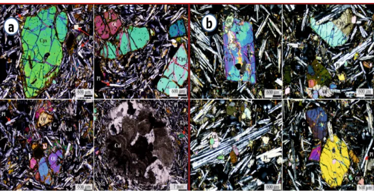
Thin section laboratory analysis of two rock samples showed that vesicles were not interconnected at microscopic scale and in some in- stances were filled by calcite, which reduces the porosity and perme- ability of the rock (Fig. 4). The dominant minerals in the rocks, following analysis by Thermo DXR Raman-spectroscope, include forsterite (Mg2SiO4) olivine, augite and diopside pyroxene, albite (NaAlSi3O8) and anorthite (Ca(Al2Si2O8)) plagioclase minerals. The augite and diopside minerals contain (Ca, Mg and Fe) and rarely aluminium too. The vesicle filling mineral in the amygdales contained calcite (CaCO3), and the opaque minerals comprise magnetite (Fe3O4), ilmenite (FeTiO3) and hematite (Fe2O3). Hematite (Fe2O3) is the most resistant mineral to weathering and might be the cause of the reddish colour of soil and/
regolith in the area. This petrological thin section analysis is in agree- ment with previous works by (Wolde, 1996) on olivine alkaline basalts and (Abate et al., 1998) who suggested the more recent Dek-Island and earlier Gimjabet-Kosober alkali basalts are likely to be the result of fractional crystallisation of the same basaltic magma source. Quaternary volcanic events resulted in the eruption of basaltic magmas through local volcanoes, and several well-preserved eruption points are visible to the south of Lake Tana. Previous works by Hofmann et al. (1997) and Abate et al. (1998) related the origin to the Afar plume and main Ethi- opian Rift. These Quaternary basalt flows are characteristically alkaline and represent the final pulse of basaltic volcanism on the Ethiopian Plateau. The Quaternary basalt dated by Prave et al. (2016) from the
Blue Nile River outlet of Lake Tana basin has a plateau age of 33,000 years.
3.2. Hydrochemistry
Groundwater geochemical properties depend on chemical constitu- ents of rainfall and the various geochemical processes as water moves from recharge to discharge areas (Freeze and Cherry, 1979; Matthess, 1982). Previous studies on Ethiopian volcanic aquifer hydrochemistry by (Ayenew et al., 2008; Demlie et al., 2007; Kebede et al., 2005;
Woldemariyam; Ayenew, 2016) provide essential highlights on geochemical variation derived from different controlling mechanisms.
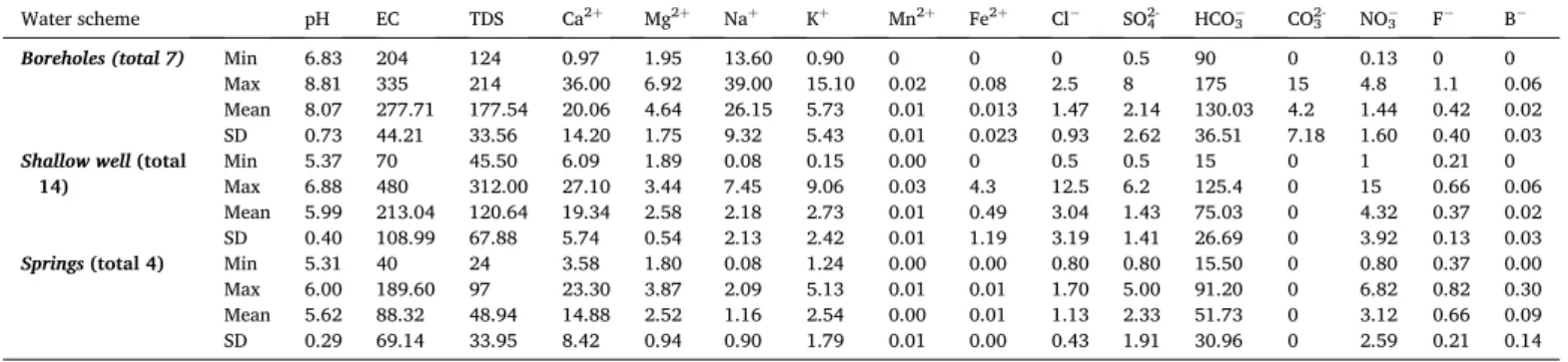
Hydrochemical laboratory analysis of representative groundwater samples of the area from boreholes, shallow wells, and springs provided the groundwater physio-chemical parameters shown in Table 1. The pH values of deep aquifers varies from 6.83 to 8.81, with a mean value of 8.07 �0.73. These values suggest that deep aquifers have neutral to weakly alkaline character. The pH values of shallow wells and springs representing the shallow aquifer system vary from 5.37 to 6.88 with a mean value of 5.62 �0.29. These values suggest that the shallow aquifer system has a character close to neutral in a few shallow wells and is weakly acidic in the remaining shallow wells and springs. The pH values in the shallow aquifer system indicate that the upper unconfined aquifer is recharged from rain locally and did not travel long distances before discharge to the surface. The increased pH value of deep aquifers is due to rock-water interaction during groundwater flow or storage in the volcanic reservoirs. TDS and EC values support these characteristics of the groundwater of the area. The groundwater of the area has very low salinity with TDS values varing from 24 to 312 mg/L. The EC values vary from 40 to 480 μS/cm with the smallest values in springs and highest in shallow wells and boreholes. The lowest EC values in the springs and some shallow wells is due to recently recharged young groundwater of the upper unconfined aquifer. The higher EC of boreholes and a few shallow wells imply that they have older groundwater and these few shallow wells possibly recharged from the greater depth older ground- water through factures. Considering all physical parameters of the groundwater (pH, TDS and EC), the lowest values are from springs, and the highest are from shallow wells and boreholes. The high values are
Fig. 4. Microscope images of thin sections from rock sample No.1(a) and No.2(b). Ol-olivine, Cpx- Clinopyroxene, Pl-plagioclase, Cal-calcite, G -glass. V- vesicular.
due to increases in dissolution of ions in the aquifers with time and depth whereas low values in shallow aquifers imply young groundwater with low residence time.
The concentration of cations and anions varies from shallow depth to the deep aquifer system of the area. The dominant cations in the bore- hole groundwater samples are in the order of Naþ>Ca2þ>Mg2þ>Kþ whereas in the shallow wells and springs are Ca2þ>Mg2þ>Naþ>Kþ. The dominant anions in both shallow and deep aquifer system are in the order of HCO3>Cl >SO42. Therefore, the most abundant cation in the deep aquifer system is Naþ, whereas in shallow aquifers is Caþ2. The groundwater system of the area, both shallow and deep aquifers, are mainly dominated by HCO3- of all other anions. The concentration of fluoride is less than 0.82 mg/l, unlike the groundwater of Ethiopian rift volcanic rocks that cause health problems (Ashley and Burley, 1994).
Though the concentration of sulphate and Nitrate is low in both aquifers system, an increasing tendency to the shallow aquifer system is observed. The low concentration of sulphate and nitrate indicates the little human impact on the groundwater but needs consideration in the future use of fertilizers that may affect the shallow aquifer system.
Except for one shallow well with 12.5 mg/L of Cl, all physical and chemical water parameters are within the drinking water limits of the World Health Organisation (WHO, 2011), making it suitable for human consumption without consideration of microbial water quality. The high value of Cl in the single shallow well is attributed to anthropogenic effects related to the well being located close to a village and being poorly constructed.
Groundwater flows are accompanied by rock-water interaction in the aquifer. Rock-water interaction changes the hydrochemistry of the groundwater and leads to trends that provide essential information about the hydrogeochemical processes and evolution (Li et al., 2014).
Piper diagrams (Piper, 1944) are often used to determine the main composition and hydrochemical facies of groundwater. The Piper dia- gram (Fig. 5) depicted five main types of water facies Ca-HCO3 and Ca-Mg-HCO3 in shallow aquifers, and Na-Ca-HCO3, Ca-Na-HCO3 and Na-HCO3 water facies in the deep aquifer system. The influence of anthropogenic pollution on the shallow aquifer leads to having a Ca-HCO3-Cl and Ca-Mg-HCO3-Cl water facies in two shallow well water samples. In a few borehole water samples, the concentration of Caþ2, Mgþ2 and Naþare significant leading to Ca-Na-Mg-HCO3 water facies.
This type of water facies might be due to intermixing of shallow and deep aquifers where fractures connect them. Variations and similarities in chemical composition have a distinct location and intermixing of water from different sources. The dominant water type in the shallow aquifer system is Ca-HCO3 which is a typical water facies in shallow young groundwater. The dominant water facies in a relatively deeper source (borehole) is Na-Ca-HCO3 and Na-HCO3 types though Ca-N- a-HCO3 water facies also can be seen. The results of the hydrochemical analysis and groundwater facies are in agreement with the study by Abiye and Kebede (2011) on the upper Blue Nile basin, a broader region
that includes our study area. Their study showed that the majority of springs have a character of Ca-HCO3 hydrochemical composition and low TDS value, however, the mineralised springs have a character of Na-HCO3 water facies.
3.2.1. Mechanisms controlling groundwater chemistry
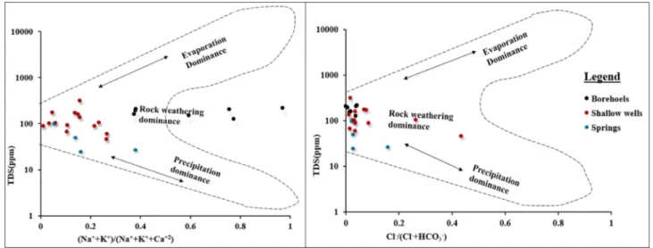
The chemistry of groundwater is affected by several factors including the original composition of recharge water or precipitation, the reser- voir rock mineralogical composition, residence time in the reservoir rock, and other characteristics of the groundwater flow path (Redwan and Moneim, 2015). Groundwater composition controlling mechanism is assessed using the Gibbs diagram (Gibbs, 1970) that relates the composition of water with its dominant sources. The three distinct zones; precipitation dominance, evaporation dominance and rock weathering dominance; have been defined and labelled in the Gibbs diagram (Fig. 6). The weight ratio of major cations Naþ/(NaþþCaþ2) is drawn on the x-axis and the variation in total salinity on the y-axis.
Similarly, the weight ratio of major anions Cl /(Cl þHCO3) versus total dissolved salts drawn for anions. In both cation and anion dia- grams, the sample locations are at the place where the rock weathering dominates as the controlling factor for the chemistry of groundwater.
Though the dominant water chemistry controlling mechanism is rock weathering, in some shallow wells and springs both rock weathering Table 1
Hydrochemical and physical summary of groundwater samples from boreholes, shallow wells and springs. Total dissolved solids (TDS), cations and anions are given in (mg/L) whereas the EC is (μS/cm). The summary presented includes the minimum (Min), maximum (Max), mean and standard deviation (SD) values of 16 groundwater parameters from the three water schemes.
Water scheme pH EC TDS Ca2þ Mg2þ Naþ Kþ Mn2þ Fe2þ Cl SO42- HCO3 CO32- NO3 F B
Boreholes (total 7) Min 6.83 204 124 0.97 1.95 13.60 0.90 0 0 0 0.5 90 0 0.13 0 0
Max 8.81 335 214 36.00 6.92 39.00 15.10 0.02 0.08 2.5 8 175 15 4.8 1.1 0.06
Mean 8.07 277.71 177.54 20.06 4.64 26.15 5.73 0.01 0.013 1.47 2.14 130.03 4.2 1.44 0.42 0.02 SD 0.73 44.21 33.56 14.20 1.75 9.32 5.43 0.01 0.023 0.93 2.62 36.51 7.18 1.60 0.40 0.03 Shallow well (total
14) Min 5.37 70 45.50 6.09 1.89 0.08 0.15 0.00 0 0.5 0.5 15 0 1 0.21 0
Max 6.88 480 312.00 27.10 3.44 7.45 9.06 0.03 4.3 12.5 6.2 125.4 0 15 0.66 0.06
Mean 5.99 213.04 120.64 19.34 2.58 2.18 2.73 0.01 0.49 3.04 1.43 75.03 0 4.32 0.37 0.02 SD 0.40 108.99 67.88 5.74 0.54 2.13 2.42 0.01 1.19 3.19 1.41 26.69 0 3.92 0.13 0.03
Springs (total 4) Min 5.31 40 24 3.58 1.80 0.08 1.24 0.00 0.00 0.80 0.80 15.50 0 0.80 0.37 0.00
Max 6.00 189.60 97 23.30 3.87 2.09 5.13 0.01 0.01 1.70 5.00 91.20 0 6.82 0.82 0.30
Mean 5.62 88.32 48.94 14.88 2.52 1.16 2.54 0.00 0.01 1.13 2.33 51.73 0 3.12 0.66 0.09
SD 0.29 69.14 33.95 8.42 0.94 0.90 1.79 0.01 0.00 0.43 1.91 30.96 0 2.59 0.21 0.14
Fig. 5. Piper diagram of hydrochemical data.
dominance and precipitation dominance is observed. There are no samples plotted on the transition domain between the rock domain and evaporation domain, suggesting the influence of evaporation on groundwater chemistry is minimal.
The relation between major ions could help to identify the change in the groundwater chemical compositions, the origin of ions, and hydro- chemical processes involved in the evolution of groundwater (Wang et al., 2013). The relationship between major cations and anions helps to identify which rock-water interaction affects the major cation and anion concentration during groundwater flow and evolution. The relationship between Naþto Cl and Caþ2 to HCO3is presented in Fig. 7 along the halite and calcite dissolution lines. The majority of shallow wells and spring samples, and all borehole samples, plotted below and to the right of the halite dissolution line (Fig. 7a). This result showed that halite dissolution is not the source of either sodium or chlorine, rather the weathering of rock-forming silicate minerals and cation exchange possibly increased the concentration of Naþfrom the shallow to the deep aquifer system. The low concentration of Naþin some shallow aquifer samples located above and left of the halite dissolution line may origi- nate from the combined effect of recharge water and limited weathering of surface or unsaturated zone rocks. A similar characteristic is the relationship between Caþ2 and HCO3values of groundwater with respect to the calcite dissolution line (Fig. 7b). The groundwater con- centrations for these ions are situated below and to the right of the calcite dissolution line that indicates the source of HCO3 ion is not CO32
that results from dissolution of calcite. The relationship plot of HCO3
and the sum effect of Caþ2 and Mgþ2 (Caþ2 þMgþ2) showed a similar
increase in bicarbonate values in groundwater from the shallow aquifer to the deep aquifer system (Fig. 8a). The continuous increase of bicar- bonate concentrations in the aquifer with residence times and depth suggests that the primary source of bicarbonate in volcanic aquifers is attributed to the existence of soil carbon dioxide interacting with water to form carbonic acid (Freeze and Cherry, 1979; Kebede et al., 2005).
The low amount of Naþand relatively higher Caþ2 and Mgþ2 in shallow aquifers is attributed to recharge water chemistry and limited rock water interaction. The increasing amount of Naþbut decreasing values of Caþ2 with depth and residence times are due to cation ex- change (exchange of Caþ2 and Mgþ2 by Naþ) and dissolution of Naþ containing silicate minerals. The trend towards increasing Naþcontent and decreasing Caþ2 content along the flow path and with depth indi- cated cation exchange, where Caþ2 was absorbed onto clay minerals and Naþwas released. This release of Naþinto the groundwater changed the chemical compositions of groundwater in deep aquifers to Naþdomi- nant. This result is supported by the relation of HCO3 versus (Caþ2þ Mgþ2) and ((NaþþKþ)-Cl-)versus ((Caþ2þ Mgþ2)-(HCO3 þ SO42)) graphs (Fig. 8a and b). The plot of goundwater samples values on ((NaþþKþ)-Cl-) versus ((Caþ2þMgþ2)-(HCO3þSO42)) graphs which is often used to study cation exchange in goundwater (Ahmed et al., 2013), have a negative relation. The negative correlation or slope of ground- water sample values is neither precisely on the line 1:1 with slope 1 nor very close to it that would show complete cation exchange had occurred (Fisher and Mullican, 1997). The plot indicates that even though there is cation exchange of major cations; Caþ2 and Mgþ2 by Naþ; the higher amount of Naþwas released into the aquifer system from weathering of Fig. 6. Gibbs diagram for Dangila Town and its surrounding area groundwater sources.
Fig. 7.NaþVersus Cl graph (a) and HCO3versus Caþ2 graph (b) of groundwater along the halite and calcite dissolution lines respectively.
Naþcontaining silicate minerals.
The results showed that calcium and magnesium cations change from dominant to subordinate cations in relation to total cations with increasing depth and as groundwater flows away from sources of recharge. Generally, groundwater associated with recharge in the shallow aquifers is represented by water dominant in calcium, magne- sium, and bicarbonates, with lesser amounts of sodium; as groundwater flows away from the source of recharge, the interaction between water and rock increases. Sodic lithologic units are encountered as the groundwater moves along a flow path and calcium and magnesium ions are exchanged for sodium ions attached to aquifer solids. Besides, the sodium-containing silicates weathering increases with depth and along flow paths so that both processes’ reactions result in a decrease in cal- cium, magnesium, and a corresponding increase in sodium and bicar- bonate as groundwater flows away from the source of recharge. This results in a water that evolves to a sodium-bicarbonate type and sodium- calcium-bicarbonate types in between recharge and discharge areas. It is possible to propose two distinct hydrochemical systems: 1) A shallow, localised, perched system with little interaction with the deeper aquifer that is hydrodynamic with the atmosphere and generally less than 25 m deep in the shallow geochemical zone, and; 2) An underlying deeper, probably regional, and relatively chemically static system in the deep hydrochemical zone along fault and fracture lines.
3.2.2. Chemical weathering of rock-forming minerals
Silicate rock-forming mineral weathering is the main factor for the prevalence of cations Caþ2, Mgþ2, Naþ, and Kþ with a significant amount in groundwater (Srinivasamoorthy et al., 2014). Forsterite, identified by laboratory analysis from rock outcrop samples, dissolves with the presence of carbonic acid. The dissolution results in magnesium ion, silicic acid and dissolved bicarbonate as follows
Mg2SiO4 þ4H2CO3 ¼>2Mg2þþH4SiO4 þ4HCO3
Pyroxene minerals, diopside (CaMgSi2O6) and augite ((CaMgFe) (MgFe)Si2O6), dissolve to produce either Ca, Mg, Fe, bicarbonate ion, and silicic acid. Diopside dissolution is given by
(CaMg)Si2O6 þ2H2O þ4H2CO3 ¼>(Ca,Mg)þ2 þ2H4SiO4þ4HCO3
Plagioclase feldspar minerals, albite (NaAlSi3O8) and anorthite (CaAl2Si2O8), undergo hydrolysis during reaction with water to give cations, clay mineral (kaolinite), silica and hydroxide as follows 4NaAlSi3O8þ4H2CO3þ2H2O ¼>Al4Si4O10(OH)8þ4Naþþ4HCO3 þ8SiO2
for albite and 2CaAl2Si2O8 þ4H2CO3þ2H2O ¼>2Al2Si2O5(OH)4þ2Caþ2þ4HCO3 for anorthite
The minor opaque mineral hematite can further react with water as
Fe2O3 þH2O ¼>2FeO(OH) (goethite), but hematite and goethite are both very insoluble in water, and they remain as residual minerals of iron oxides that give many soils their reddish colour. Chemical weath- ering of silicate minerals produces insoluble clay minerals, positively charged metal ions (Ca2þ, Mg2þ, Naþ), negatively charged ions (OH , HCO3) and some soluble silica. The presence of these ions in soil and water causes variations in groundwater chemistry.
3.2.3. Water quality for irrigation
The trend of using groundwater for small-scale irrigation at small backyard agricultural land is expanding because of its simplicity and ease of management. The aptness of groundwater for agricultural use depends mainly on the mineralogical contents of the water in soil and plants. Salts in groundwater can change soil structure, permeability and aerations, which in turn affect plant development. The sodium adsorp- tion ratio (SAR), sodium percentage (Na %) and residual sodium car- bonate (RSC) are the commonly employed parameters to assess the suitability of water for irrigation purposes. SAR has been the benchmark measure of probable sodium hazard for irrigation water by United States Salinity Laboratory Staff (1954). It is the relative concentration ratio of Naþions to Caþ2 and Mgþ2 ions in irrigation water which is used to estimate the potential accumulation of Naþin soil due to regular use of sodic water for irrigation. The relationship between SAR in irrigation water and the extent to which the soils adsorb sodium helps to decide the suitability of water for irrigation. When high sodium and low calcium water is used for irrigation, the cation exchange complex may become saturated with sodium, which can damage the soil structure due to the distribution of clay particles (Singh, 2002). It will reduce water move- ment and aeration in soils and will affect the growth of plants and reduce crop yield. The deficiency of Caþ2 and Mgþ2 may arise due to the high accumulation of Naþ, which means the evaluation of sodic water hazard is essential. SAR is determined using the equation given below (Suarez et al., 2006).
SAR¼ Naþ ffiffiffiffiffiffiffiffiffiffiffiffiffiffiffiffiffiffiffiffiffiffiffi ðCa2þþMg2þÞ
2
q (1)
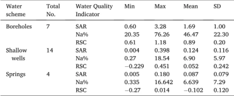
where Naþ, Caþ2 and Mgþ2 are in meq/l. SAR values ranged from 0.004 to 3.28, with a mean varying from the value of 0.087 �0.079 to 1.69 � 1.00 respective to the three groundwater schemes in the study (Table 2).
The plot of electrical conductivity (μS/cm) versus SAR on the US regional laboratory staff salinity diagram (1954) illustrates that most of the groundwater samples of boreholes belong to the categories C2S1, which is medium salinity and low sodium (Fig. 9). The shallow well samples belong to both C2S1 and C1S1 (low salinity and low sodium) whereas the samples from springs belong to C1S1 categories. All samples from the three groundwater schemes fall in low sodium class (S1) with SAR values <10, which shows that no alkali hazard is anticipated to crops. Shrinking and swelling of clay soil particles can occur if the Fig. 8.HCO3versus (Caþ2þMgþ2) graph (a) and (NaþþKþ)-Cl- versus (Caþ2þMgþ2)-(HCO3þSO42) graphs (b) of groundwater respectively.
amount of SAR in the irrigation water is greater than 6–9 (Saleh et al., 1999). The C2S1 and C1S1 categories of water with low to medium salinity and low sodium water imply the groundwater can be used for irrigation on all types of soil without any danger of exchangeable sodium.
Na % is considered as a parameter for determination of water suit- ability for irrigation (Wilcox, 1948). The reaction of Naþwith a weak acid (CO32 ) results in alkaline soil, whereas Naþreacts with strong acids (Cl ) resulting in saline soils. Both alkaline and saline soils retard plant growth (Todd, 1980) because high concentration of Naþin irrigation water will remove Caþ2 and Mgþ2 ions through a base-exchange reac- tion in clay soil particles. The exchange of Caþ2 and Mgþ2 by Naþwill reduce water and air movement and the soils will become hard during the dry season (Saleh et al., 1999).
Na % is calculated using the formula, Na%¼
� Naþ
Ca2þþMg2þþNaþþKþ�
�
x100 (2)
where Naþ, Caþ2, Mgþ2 and Kþare in meq/l. The Na % of groundwater samples from boreholes ranged from 20.35 to 76.26 with mean of 46.47
�22.30; samples from shallow wells ranged from 0.27 to 18.54 with mean of 6.90 �5.97, and samples from springs ranged from 0.335 to 16.642 with mean of 6.639 �7.29 (Table 2). Irrigation water is classi- fied based on Na% as excellent (<20%), good (20–40%), permissible (40–60%), doubtful (60–80%) and unsuitable (>80%). The Na% values indicate that the groundwater from springs and shallow wells are excellent whereas from boreholes range from good to doubtful cate- gories. Using groundwater from boreholes that can yield a high amount of water for irrigation, without any adjustment may result in the high
concentration of Naþthat leads to a reduction in permeability and in- ternal drainage of the soil.
Excess amount of RSC, which results from the sum of carbonate and bicarbonate, also affects the suitability of groundwater for irrigation use.
RSC is calculated as follows based on the United States Salinity Labo- ratory Staff (1954).
RSC¼ HCO3 þCO23 �
Ca2þþMg2þ�
(3) where HCO3, CO32, Caþ2 and Mgþ2 are in meq/l. RSC values range from 0.61 to 1.18 with mean of 0.89 �0.20 for the boreholes, from 0.229 to 0.451 with mean of 0.052 �0.242 for the shallow wells, and from 0.27 to 0.014 with mean of 0.102 �0.120 for spring samples (Table 2).
Based on the RSC value ranges, the United States Salinity Laboratory Staff (1954) classified irrigation waters into three categories; RSC values <1.5 (probably safe), 1.5 to 2.5 (marginal) and >2.5 (not suit- able) for irrigation use. The RSC values of all the samples from the three groundwater schemes have less than 1.25 and are considered suitable for irrigation. Moreover, the RSC values in boreholes denote that Naþ existence in the soils is possible, whereas the negative values in shallow wells and spring samples denote that the concentration of Ca2þand Mg2þis in excess. The different classification of water for irrigation use based on the three water quality indicators is summerised in Table 3.
The groundwater of the area is in a good quality but can be vulner- able to contamination. The sustainability of the groundwater for irri- gation use from the shallow weathered volcanic aquifer during the dry season is problematic. The distribution of the shallow wells in farmlands increases their exposure to anthropogenic contamination.
3.3. Aquifer properties 3.3.1. Shallow aquifer
The clay soil and regolith, being at high altitude, are always under the influence of rainfall, temperature variation, and erosion. Precipita- tion in the area seeps through the soil and recharges the upper-perched aquifer. Rock fragments, consisting of well-rounded Quaternary vesic- ular basalt, usually highly weathered, are both resting on the soil surface and partly embedded in the top layer. Walker et al. (2019b) have esti- mated recharge of this shallow aquifer at 280–430 mm/year or 17–26%
of mean annual precipitation. The shallow hand-dug wells that abstract groundwater from the upper unconfined aquifer are 98% productive.
The maximum water yield of a given shallow well is usually less than 1 L/s and even lower for wells, which did not encounter shallow fractured basalt below the regolith. Springs are both topographic and fractured controlled in depressions, through faults or fractures and emerge from the upper unconfined perched aquifer with usually less than 1 L/s yield.
Investigations by Walker (2016) on unconfined upper soil and regolith aquifer of five wells in the same study area, calculated mean hydraulic conductivity values of 2.3 m/d in the dry season and 9.7 m/d in the wet season when saturated thickness was greater and more transmissive Table 2
The maximum, minimum, means and standard deviation values of SAR, Na%
and RSC in the groundwater.
Water
scheme Total
No. Water Quality
Indicator Min Max Mean SD
Boreholes 7 SAR 0.60 3.28 1.69 1.00
Na% 20.35 76.26 46.47 22.30
RSC 0.61 1.18 0.89 0.20
Shallow
wells 14 SAR 0.004 0.398 0.124 0.116
Na% 0.27 18.54 6.90 5.97
RSC 0.229 0.451 0.052 0.242
Springs 4 SAR 0.005 0.180 0.087 0.079
Na% 0.335 16.642 6.639 7.29
RSC 0.27 0.014 0.102 0.120
Fig. 9. Classification of groundwater using US regional laboratory staff (1954) salinity diagram.
Table 3
Classification of water for irrigation use based on SAR, Na% and RSC values.
Parameter Range Water class Water scheme
Boreholes Shallow wells Springs
SAR <10 Excellent 7 14 4
10–18 Good Nil Nil Nil
18–26 Doubtful Nil Nil Nil
>26 Unsuitable Nil Nil Nil
Na% <20 Excellent Nil 14 4
20–40 Good 3 Nil Nil
40–60 Permissible 2 Nil Nil
60–80 Doubtful 2 Nil Nil
>80 Unsuitable Nil Nil Nil
RSC <1.25 Good 7 14 4
1.25–2.5 Doubtful Nil Nil Nil
>2.5 Unsuitable Nil Nil Nil
layers were intercepted. The hydraulic conductivity of the shallow aquifer is low and has slow recovery after abstraction.
Groundwater discharges via springs, streams or in some cases, via wetlands from the unconfined upper perched aquifer. The perched aquifer has high interaction with rainfall and rivers. A time series of rainfall and river stage measurements collected within the study area, locally called Dangesheta kebele, by (Walker et al., 2019a) showed that the rivers are very flashy with sharp peaks in river stage quickly following rainfall events. The groundwater levels from shallow wells follow a similar pattern of seasonal variation and fluctuation. The fractured zone below the soil and regolith profoundly affects the hy- draulic properties shallow depth aquifers. Lack of fractured zones causes a gradual decline of groundwater levels during the dry season, and their presence below the regolith rapidly increases the amount of water in the shallow wells during the rainy season.
3.3.2. Deep aquifer
There are varying degrees of weathered and fractured Quaternary basalt, scoriaceous basalt and scoria fall in the confined and semi- confined deep aquifers. The most productive boreholes consist of more fractured layers. Generally, the boreholes have multi-aquifers of various thicknesses with alternating layers. Unlike the upper unconfined soil and regolith aquifer, which is recharged from rainfall, the deeper vol- canic aquifers are recharged from the upper unconfined shallow aquifer through fractures and faults. The deeper faults/fractures are expected to serve as conduits to the lower aquifers. Hydraulic conductivity and borehole yields are high for boreholes that penetrate the deeper fracture zones. The depth of water strikes varies between boreholes in addition to the aquifer type, which makes it challenging to confirm different pres- sure heads.
In the productive borehole DTW1 that yields 24.5 L/s groundwater, the primary fracture zone with enormous quantities of water is detected at a shallower depth. The water bearing zone of the borehole DTW2 that yields 3.5 L/s groundwater, is situated at greater depth than in DTW1 and the water is mainly contained in weathered and fractured vesicular and scoriaceous basalts. The most productive borehole of the area, DTW3 that yields 30 L/s groundwater, has fractured zones at shallow depth and highly weathered scoria layers at greater depth.
In general, the water-bearing geological formations indicate that the potential of the aquifers increases where the basalt provides fracture zones and weathered scoria layers. These fracture zones may be aquifers in their own right or link several water-bearing layers of scoria and scoriaceous beds. They may also link weathered basalts, basaltic frac- tures, and vesicles related to lava cooling. When fractures connect the water-bearing porous layers, these locations will be ideal for drilling boreholes. The hydraulic conductivity (K) of the deeper confined and semi-confined aquifers are estimated using data gathered during bore- hole pumping tests. The K values are calculated for three productive boreholes (DTW1, DTW3, DTW4), and a nonfunctional borehole (DTW2) using Moench fracture flow model (Moench, 1984) and the values are given in (Table 4). The hydraulic conductivity of the bore- holes dominated by fractures is higher, and during pumping tests, the recovery of these boreholes was fast.
The complex volcanic rock setting of the area influenced by weath- ering and deformational processes cause it to be intricate for ground- water exploration and sustainable management. The results of Quaternary basaltic magma eruption through different eruption centres,
different lava flow directions and timing, exposure to surface weath- ering as well as deformational activities causes the Quaternary basalt, scoriaceous basalt and scoria to vary laterally and with depth. These lead to a multi-aquifer system with several alternating aquifer layers that communicate with fractures and fault lines or make discontinuous and heterogeneous aquifer system. The infilling of secondary minerals (calcite and zeolite) in vesicular basalts cause reduction of porosity, but weathering and fracturing lead to an increase in porosity and perme- ability of the reservoir rocks.
3.4. Hydrogeological conceptual model
The findings of this study showed that neither of the available Islandic volcanic aquifer conceptual model nor the previous large-scale conceptual groundwater flow model of Ethiopian volcanic aquifers could be adapted without modification for the study area. Since there is no continuous basal aquifer, the two most commonly employed hydro- geological conceptual models for volcanic aquifers of basaltic islands;
the Hawaiian model (McDonald et al., 1983) having a low-lying basal aquifer linked to inland dyke-impounded and perched aquifers, and; the Canary Islands model (Custodio, 1989) having a continuous basal aquifer, cannot be employed. The perched aquifer of the Hawaiian model has some similarity to the upper-perched aquifer of our model.
The upper unconfined perched aquifer in the soil, regolith, and occa- sionally in the upper fractured basalt, has a resemblance to the Mayotte model (Lachassagne et al., 2014). The Mayotte hydrogeological con- ceptual model for complex multiphase partly eroded and subsided basaltic islands, describes the main hydrogeological structures as superimposed palaeovalleys filled with various types of volcanic prod- ucts. Its discontinuous and perched aquifer lacking a continuous basal aquifer resembles the Dangila area model (Fig. 10). Though there are similarities, the Mayotte model cannot be adapted because: 1) Mayotte model has several discontinuous perched aquifers with depth, but Dangila model has a single upper unsaturated soil and regolith aquifer;
2) In the Mayotte model, groundwater flows through low permeability volcanic rocks and discharges as springs when the perched aquifer in- tersects the surface.
In the Dangila model, flow is highly controlled by fractures/faults, and the deeper aquifers found at depths extending up to 210 m below the surface is recharged from the upper unconfined aquifer through frac- tures. The permeability of the lower aquifers are not low due to the presence of weathered and fractured Quaternary basalt, scoriaceous rocks and scoria, but their interconnection depends on the nature and density of fracture lines. The layers may have fractures to store and transmit groundwater but need another high aperture fracture to be connected to other shallower or deeper weathered and fractured layers.
The Dangila model does not resemble the groundwater flow model of the Tana basin (Fenta et al., 2016) due to its fracture dissected flow systems.
The conceptual model is in agreement with the shallow aquifer con- ceptual model of the area by (Walker et al., 2019a), who also noted the lack of interaction between shallow and deep groundwater. The model will have a considerable advantage in exploration and management of groundwater from volcanic aquifers of complex geological setting affected by the fault, fracture or rifting. It can be transferred to an area with a similar geological setting for groundwater exploration with great emphasise to fracture networks.
Table 4
Hydraulic conductivity, transmissivity and storage coefficient values of four selected deep boreholes.
No. Borehole ID Hydraulic Conductivity (m/d) Transitivity (m2/d) Storage Coefficient Aquifer Character
1 DTW1 3.63 �101 6.53 �101 9.17 �102. Fracture dominant
2 DTW2 5.7 �102 8.5 �100 6.02 �102 Both fracture and weather dominant
3 DTW3 3.6 �101 5.20 �101 6.25 �102 More Fracture, less weathered dominant
4 DTW4 9.76 �103 1.37 �100 5.00 �102 More fracture, less weathered dominant
3.4.1. Sustainable groundwater management of Dangila town and surrounding area
Population growth, establishment of new settlements, agricultural expansion, application of fertilizer and pesticides, increased attention of freshwater bottling companies and decreasing groundwater yields of wells all point to a need for better monitoring and sustainable man- agement of groundwater. Groundwater quality and hydrogeological framework studies will assist the water sector to sustainably manage groundwater as the only available freshwater of the area. The sustain- able management for rural development is dependant on research re- sults to enable wise utilisation of the diverse geological setting of volcanic aquifers. The common utilisation of groundwater in the study area and throughout Ethiopia has traditionally been through the use of hand-dug shallow wells and springs. Drilling of deep wells requires a tremendous amount of budget, and insufficient study will cause a lot of budgets to be spent ineffectively. The deep drilling and pumping tech- nology in the country since the 1970s has enabled groundwater exploitation and human settlement to be extended in response to the increasing population though the sanitation risk of the shallow groundwater is still questionable.
The intensive use of fertilizers and pesticides for agriculture affects surface water. The Ethiopian government is currently implementing countrywide irrigation projects using groundwater (Mengistu et al., 2019) and the results of this study could be used for sustainable devel- opment in the area. Moreover, the results of the study showed that the groundwater of Dangila town and its surrounding area is good quality for drinking and industrial use while needing few adjustments on the deep groundwater for irrigation due to Na% that will lead to sodicity of the soil. The use of irrigation water from springs and shallow wells is appropriate concerning quality, but yield is meagre and cannot be used for more than small-scale backyard agriculture. The future management of groundwater for sustainable development in the area should focus on modelling of structural groundwater flow and anthropogenic pollution due to locations of shallow wells in agricultural land. Traditional prac- tices to manage groundwater based on observation and previous data
alone will lead to loss of time and budget, and overexploitation of groundwater from a single source or scheme will lead to reduction of groundwater yield over time. Furthermore, for sustainable groundwater use and management in the area, the focus should be to understand the flow system, locate appropriate drilling sites, evaluate anthropogenic pollution and the sodicity effects of soil due to sodium.
4. Conclusions
The approach of analysing and interpreting various data sets helped to understand the hydrogeological framework and groundwater quality of the area. The results of the study showed that the volcanic aquifer systems of the area comprise a multi-aquifer system with alternating groundwater-bearing layers. A perched unconfined aquifer in the upper soils and regolith overlies confined and semi-confined aquifers in the weathered and fractured rocks. Fractures with high hydraulic conduc- tivity principally control both groundwater storage and flow, and the presence of weathered scoria is paramount.
Chemically and physically, the groundwater is of good quality for both drinking and irrigation use, except Na% from deep boreholes that can result in sodic soils if implemented without any adjustment. The groundwater of the area is mainly Ca-HCO3 type in the shallow aquifer, and Ca-Na-HCO3, Na-Ca-HCO3, and Na-HCO3 types in deep aquifers.
Rock-water interactions involving silicate weathering, cation exchange and carbonation are the main hydrochemical processes that control the major composition of the groundwater. A hydrogeological conceptual model affected by structures and representing a dissected groundwater flow system was developed using information from various data sets for future sustainable groundwater management.
Acknowledgement
The authors would like to thank Dangila woreda Water Bureau of Ethiopia for their information about the status of shallow hand-dug wells and spring data. We are also grateful to Amhara Water Works Fig. 10. Hydrogeological conceptual model of Dangila town and its surrounding area.Vertical represents elevation of the area (m) and horizontal represents dis- tances (m).