ALLUVIAL
PLAINS
SUMMARY
Introduction ...
i... 3
What are alluvial plains? ... 5
Where alluvial plains are found ... 6
The plains as a natural resource ... .. 8
A complex system affected by environmental changes . . 10
How to gain knowledge about the plains ... 13
Geological maps ... 16
The formation of alluvial plains ... 17
Emporda p la in ... 19
The lower Rhine alluvial p la in ... 21
The Little Hungarian p la in ... 24
The Po plain ... 27
Conclusion... 30
ALLUVIAL PLAINS
Generalität de Catalunya Departament de Politica Territorial i Obres Pübliques Institut Cartogräflc de Catalunya Serv» Gsotögic de Catalunya
SEegiOneEmilia-Romagna i f e l V y N - h ^ ^ o f A ^ G ^ ^ T N O
Geological Office C - National Geological Survey
Alluvial plains
First edition: June 1 9 9 7
Edited by: Xavier Berástegui and W im de Gans Contributors: Xavier Berástegui
W im de Gans G yörgy Don M ik ló s Kaiser M ariona Losantos Péter M olnár Antal Pentelényi Raffaele Pignone Carme Púig Péter Scharek Paolo Severi Tib o r Tullner István Zsám bok
Published by:
Institut C artogrdfic de Catalunya Servei Geologic de Catalunya
Parc de Montjuic, 0 8 0 3 8 Barcelona - Catalonia - Spain Tel.: 3 4 -3 -4 2 5 2 9 0 0 - Fax: 4 2 6 7 4 4 2 - http://w w w .icc.es
Em ilia-Romagna Region. Geological Office
Viale Silvan«, 4-3 - 401 22 Bologna - Italy - Tel.: 39-51-28 44 83 - Fax: 39-51-28 42 08 Hungarian Geological Survey. Geological Institute of Hungary
Stefánia út 14 - H-l 143 Budapest - P. Box 106 - H-1442 Budapest - Hungary - Tel.: 36-1-267 14 26 - Fax: 3(5-1-251 0 7 03 Netherlands Institute o f Applied Geoscience T N O - National Geological Survey
Richard Holkade, 10 - P. Box 157 - 2 0 0 0 AD Haarlem - The Netherlands - Tel.: 31-23-530 03 0 0 - Fax: 31 -23-535 16 14
© Institut Cartogrdfic de Catalunya (ICC), fo r this edition
© Netherlands Institute o f Applied Geoscience T N O - National Geological Survey (N ITG -TN O );
Em ilia-Romagna Region. Geological Office (U G ER), and Hungarian Geological Survey. Geological Institute o f Hungary (M AFI), fo r their respective pictures and photographs
IS B N : 8 4 - 3 9 3 - 4 2 7 9 - 9 D .L.: B. 2 4 3 9 2 - 1 9 9 7
Printed on 100% chlorine-free paper
Cover: N ile Delta (From: ICC, satellite N O A A , sensor A V H RR, july 1 996) Inside cover: Photo: P. M olnár
INTRODUCTION
Th is booklet was prepared by four european national and regional geological su r
veys that are involved in the study of "alluvial plains".
Alluvial plains are a part of the uppermost part of the Earth's crust, and as such, supporters of life. T h is part of the lithosphere also holds all the currently accessible mineral resources. However, its capacity of production and storage is limited and, as its geological structure is very complex, it is very sensitive to the modifications caused by modern human development. Extraction activities, such as mineral or groundwater pro
duction, and storage in a broad sense, such as building, the altering of river courses or waste disposal sites, can result in profound changes in the properties of soils and sub
surface sediment. H istory on a human scale shows how such changes can eventually lead to a definitive loss of extensive areas which were previously the sites of flourishing activities.
In the course of the following pages we explain what alluvial plains are, how they were formed, why people have always chosen them as their dwelling-place and why and how the alluvial plains are so much at risk of damage by human action.
Th is booklet is dedicated to all those people who are very attentive to knowledge about natural environment, its preservation and their geological heritage.
The geological surveys of the Netherlands, Hungary, Catalonia and Em ilia - Romagna believe in the exchange of scientific knowledge and methodologies, and con
sider that the diffusion of acquired knowledge is of fundamental importance to any further development.
3
WHAT ARE ALLUVIAL PLAIN S?
A lluvia l plains are relatively flat areas composed of alluvium. Rivers transport water and sediment from higher to lower ground, and eventually reach the sea. There they build a delta or an estuary, and alluvial deposits merge imperceptibly with adja
cent lagoonal, estuarine, tidal flat and beach deposits. Alluvial plains accompany the streams; they may start out as very narrow and near the sea become tens of kilometres wide, where the alluvial plain merges with a coastal plain.
During floods alluvial plains receive new alluvium: coarse-grained sediment is depo
sited in and close to the stream; fine-grained sediment may be deposited at a greater d is
tance. Alluvial soils are recent deposits of alluvium; they may be very fertile depending on their chemical and mineralogical composition, which, in turn, depend on the nature of the rocks cropping out in the drainage basin.
The basin necessary to hold the sediment carried by the streams, thus forming the alluvial and coastal plains, is generated by a natural process that geologists know as subsidence. As a result of this process, a large part of the Earth's crust downwarps in relation to the surroundings. Natural subsidence rates in coastal plain areas with acti
ve deposition are typically 0 .2 -5 .0 mm/year.
A llu v ia l pla ins can be very old. The Po a lluvia l plain came into being some 7 0 0 0 0 0 years ago. The Rhine a lluvia l plain in the Netherlands emerged about 1 0 0 0 0 0 0 ye a rs ago. The firs t a llu via l fan of the ea rly Danube riv e r occurred 2 5 0 0 0 0 0 years ago in the Carpatian Basin.
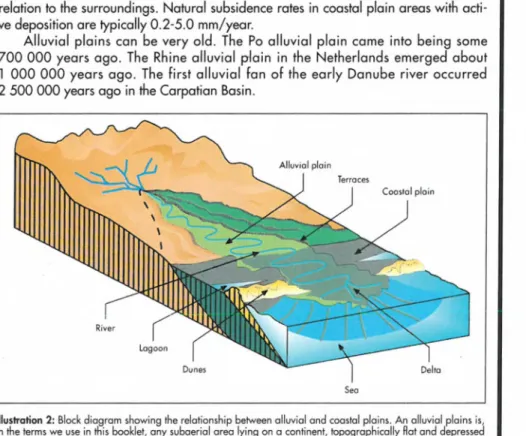
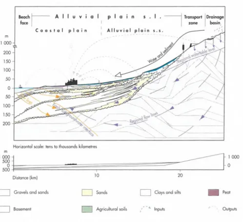
Illustration 2: Block diagram showing the relationship between alluvial and coastal plains. An alluvial plains is, in the terms we use in this booklet, any subaerial area lying on a continent, topographically flat and depressed with respect to the surrounding higher relief, sometimes w ith a side open to a sea, fed w ith sediment and water carried by streams, even though the sediment is subsequently reworked by m arine coastal processes. Th u s, according to this definition, the term alluvial plain includes a wide variety of sedimentary environments and their particular related processes: alluvial fans, braided and anastomosing streams, meander belts, aeolian, lacustri
ne, swamp, marshes, evaporitic, coastal and deltaic plains, and tidal flats. (From: N ITG -TN O )
5
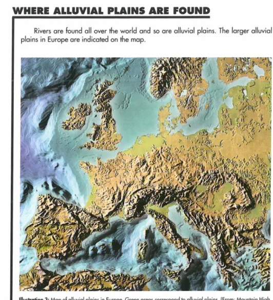
WHERE ALLUVIAL PLAINS ARE FOUND
Rivers are found all over the world and so are alluvial plains. The larger alluvial plains in Europe are indicated on the map.
Illustration 3: M ap of alluvial plains in Europe. Green areas correspond to alluvial plains. (From : Mountain High M a p s® C opyright© 1 9 9 3 Digital W isd o m , Inc.)
6
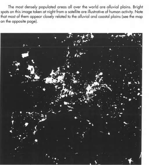
The most densely populated areas all over the world are alluvial plains. Bright spots on this image taken at night from a satellite are illustrative of human activity. Note that most of them appear closely related to the alluvial and coastal plains (see the map on the opposite page).
Illustration 4: Satellite image o f w orld at night. (From: Earth at Night. Poste r© 1 9 8 6 Hansen Planetarium)
7
THE PLAINS AS A NATURAL RESOURCE
Human cultures evolved on plains. Agricultural production was the most important activity in the millennia preceding the industrial revolution. Between 7 0 0 0 and 6 0 0 0 BC e a rly farm ing developed on the upstream parts of the a llu via l p la ins of the Euphrates and the Tig ris. The first settlement occurred around 6 0 0 0 BC. Between 5 0 0 0 and 3 0 0 0 BC this plain and that of the Nile were cleared and irrigated, and city life developed. Up to V-IV centuries BC, mixed farming with villages developed on southern Europe's plains; at that time the Phoenicians and the Greeks expanded their commer
cial networks to the western Mediterranean, established their cities and brought modern farming technologies to the autochtonous populations. The Danube alluvial plain is of importance to the spread of mixed farming in the north-west part of Europe.
The Roman occupation (third century BC in the Po plain; 2 1 8 BC in the Empordà plain, 1 st century AD on the banks of the Danube) brought more modern farming and com
munication technologies, beginning cultivation on the recent Rhine plain in the Netherlands in about 2 5 0 BC.
These early areas of cultivation on the European alluvial plains slowly developed into centres of population, agriculture, trade and culture. Th is development was stimu
lated by:
- the presence of agricultural soils, - large reservoirs of fresh groundwater,
- a relatively flat surface which favoured the construction of roads,
- the presence of rivers which were favourable for shipping and trade, and
- the presence of large quantities of construction materials such as gravel, sand and clay.
In historical terms, the ownership and control of alluvial plains represented the power of the empires. Therefore, it was not by chance that alluvial plains were the scene of the largest m ilitary operations as well. They were also the scenes of river regu
lations, the transport of goods and voluntary or forced migration, facilitating the impro
vement of engineering, the road network and the expansion of civilisation.
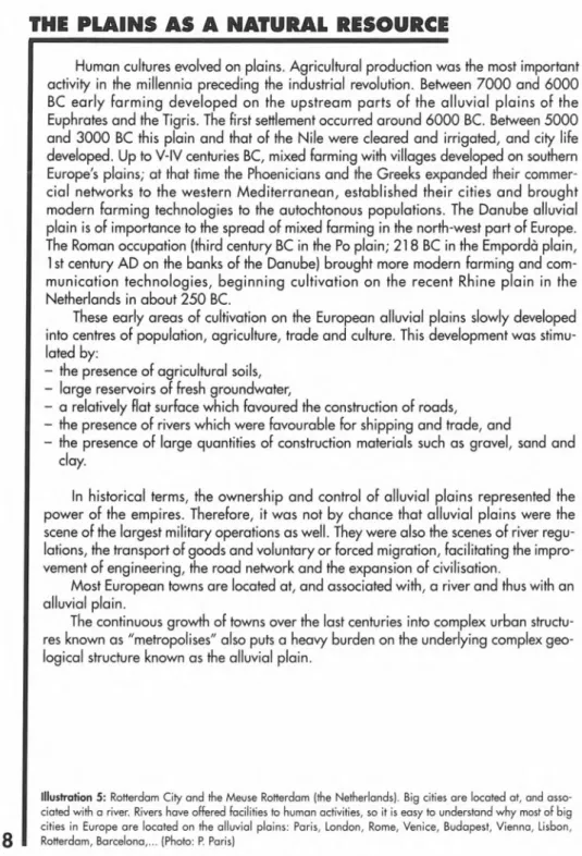
Most European towns are located at, and associated with, a river and thus with an alluvial plain.
The continuous growth of towns over the last centuries into complex urban structu
res known as "metropolises" also puts a heavy burden on the underlying complex geo
logical structure known as the alluvial plain.
Illustration 5: Rotterdam City and the Meuse Rotterdam (the Netherlands). Big cities are located at, and asso
ciated w ith a river. Rivers have offered facilities to human activities, so it is easy to understand w hy most o f big cities in Euro pe are located on the alluvial plains: Paris, London, Rome, Venice, Budapest, Vienna, Lisbon, Rotterdam, Barcelona,... (Photo: P. Paris)
5|pPÍ
fïïdtu^ÿtiÿ К W f - '/ 'M
#ЯШщ К i / • '
A COMPLEX SYSTEM AFFECTED BY ENVIRONMENTAL CHANGES
The great increase in the demand for water that has occurred in Europe in the last 3 0 -4 0 years is jeopardising the age-old balance between human beings and alluvial plains and is changing the life of the plain. The development of agriculture, farming and industry is a source of problems to the plain itself, and to the resources it contains.
The sediment forming the alluvial plains is unconsolidated material, and ground- water is filling the pores between the grains. If the sedimentary bodies containing water in their pores are capable of producing, they are called aquifers. As this water is exploi
ted (e.g., by pumping) at a correct rate, these aquifers are automatically refilled by water infiltrated from rivers and rainfalls, and thus the pore size is preserved. Overexploitation of the aquifers causes a drop in water-table level and the extraction of the thinnest grains of sediment. Th is results in a dramatic decrease in pore size. The subsequent compaction of the sediment leads to a drop in the ground level. Th is phenomenon, called subsidence by dewatering, is widely known in most alluvial plains throughout the world and is the cause of the actual sinking of buildings into the ground. Measured subsidence rates due to dewatering and sediment compaction, depending on the composition of the sediment, range between up to 1 80 mm/year (Mexico City) and 4 mm/year (Venice). Similarly, the exploitation of hydrocarbons trapped in the pores of sedimentary bodies -known as reservoirs- in the deep subsurface of some alluvial plains, also results in a decrease in pore size. The subsequent compaction of the sediment leads to subsidence and to the drop in ground level. Measured rates of subsidence due to hydrocarbon extraction in Long Beach, California, are as much as 2 6 0 mm/year. In other cases, rapid subsidence processes can be caused by natural phenomena -fo r instance, the oxidation of peat after drainage, as occurs over large areas on the Dutch plain.
Groundwater overproduction in coastal areas can also result in severe chemical changes in water quality. Intense exploitation of coastal aquifers induces a salt-water intrusion, which eventually leads to the loss of the resource or, in the case of use for ir r i
gation purposes, to the salinisation of the cultivable soils and their subsequent loss for agriculture. Other changes in groundwater quality can originate from an excessive use of chemical products in modern agriculture and farming, from uncontrolled waste d is
posal sites or from industrial pollution.
Important changes in the dimensions and morphology of the alluvial and coastal plains are also induced by human pressure, by modifying the riv e rs' discharges.
Deforestation and intense agricultural and pasture activities in the drainage basins, as occurred during the 1 7th to the early 19th centuries in Southern Europe, result in an increase of the sediment charge of the rivers. Th is produces a rise in ground level in the interior alluvial plains, and a growth of the coastal plains, basically through catastro
phic floods. Conversely, the construction of dams in the main rivers, which started in the early years of this century for irrigation and hydroelectric purposes, has produced a marked decrease in the sediment discharges at the mouth of the rivers, which results in the subsequent loss of emerged land on some coastal plains. As an example, since the Aswan High Dam was completed (1 971), 98 percent of the N ile sediment has been trapped in southern Lake Nasser forming a new delta, and the Nile delta is losing half a square kilometre of land per year.
10
Gravels and sands
Basement
Sands | Clays and silts
Agricultural soils ' 4 Inputs
Peat
Outputs
Illustration 6: A lluvial plains are typically composed of stratified gravels, sands, silts and clays, deposited by streams in the areas in, and adjacent to the stream, and peat, black organic rich muds, o r layers o f salts depo
sited in areas o f stagnant waters. These deposits are called "alluvium ", from the Latin w ord fo r "flo o d". The allu
vium can be later reworked by aeolian o r marine processes, thus giving way to dune fields o r beach complexes.
W a te r flow lines have been drawn to show the water path and, so how alluvial plains hold large reservoirs of groundwater.
Outputs indicate some human actions that have a negative effect on the alluvial plains natural properties: sea water contamination, groundwater contamination and atmospheric contamination,...
Inputs indicate some resources taken from alluvial plains by humans: groundwater, agricultural soil, construction materials, peat,... (From : ICC.SGC)
11
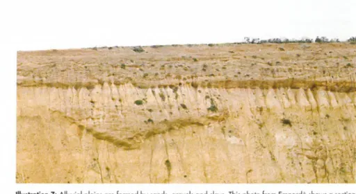
Illustration 7: Alluvial plains are formed by sands, gravels and clays. T h is photo from Empordà shows a section o f sediment form ing an ancient alluvial plain. (Photo: J. Picart)
However, modifications to life on the plain do not only depend on human activity.
Geological records show how climate has always played an important role in alluvial plain growth or destruction. Many climatic oscillations have occurred in the past:
periods characterised by heavy ra ins were followed by dry periods; warm periods were followed by cold periods; and periods with a sea level that was higher than at present were followed by others with a sea level below the level we know today. A ll these changes and their combinations have a direct effect on the amount of water and sediment supplied by the rivers feeding their alluvial and coastal plains, and on the dynamics of the marine coastal processes. In short, an effect, on the increase or decrease in the alluvial and coastal plain areal extension. Moreover, geological records show that these changes in the physiognomy of the alluvial plains are also produced in a catastrophic way, again through floods.
The severest climatic variations cause a growth or a melting of the polar ice caps.
A s more or less oceanic water is trapped or not as ice, the result is respectively a glo
bal drop o r rise in sea level. The total rise in sea level caused by the melting of Pleistocene ice sheets is thought to have been 1 30 m, at a rate of 10 mm/year.
12
HOW TO GAIN KNOW LEDGE ABOUT THE PLAINS
In order to forecast and plan the future of the alluvial plain, it is necessary to be aware of the present and to be able to reconstruct its past evolution. Th is is part of the work that geological surveys achieve every day, in order to gain a knowledge of the land, an expensive task, but one of great benefit to society.
Systematic basin analysis with the elaboration of special related tools has been completed during this century as a result of the development of technologies for hydro
carbon exploration, the most important industrial resource, and healthy drinking water, the most important factor for life.
Beside standard surface investigation methods based on direct observations and measurements, geologists use other methodologies based on indirect criteria to preci
sely define the composition and geometry of the sediment in the subsurface of the allu
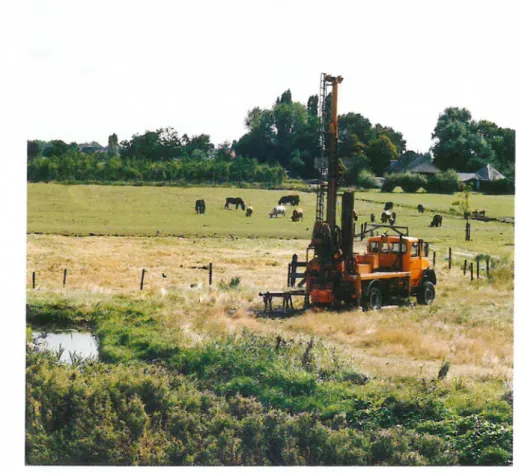
vial plains and those of their basements. These methodologies, consisting of the measurement of some physical parameters of the rocks (basically magnetism, electric conductivity and resistivity, acoustic impedance, density or gravity) are known by the generic name of geophysical tools. However, surface geophysical methods cannot give accurate information about the chemical composition of the sediment, about its age and about physical parameters such as permeability and other important technological features. Some semi-direct methodologies, such as Cone Penetration Tests (CPTs), give an idea about the resistance to penetration of the sediment. But most data can only be obtained by direct observation and measurement. Although very costly, boreholes are the only feasible methodology. Boreholes allow the collection of rock samples and geophysical measurements in the well using specific technologies.
The data collected by means of this range of tools are then used to generate a wide variety of maps, from the preliminary general geological map constructed mainly from surface observations, to derived geo-thematic maps displaying the areal distribution of the physical parameters measured. From these data, geologists also develop physical, analogue and mathematical models. These models allow them to reproduce, step by step, the past evolution of the alluvial plain and, much more importantly, to predict its behaviour if one or more parameters are modified.
13
Illustration 8: D rillin g machine of the N IT G - T N O in action in the alluvial plain o f the Netherlands. (Photo: N ITG - T N O ; J. M . P. K. van Delft)
14
m s s p i f ü ® s s s s
« « . s s - *
■
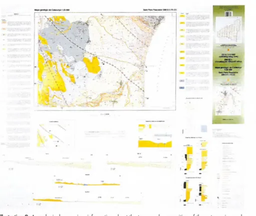
Illustration 9: A geological map gives inform ation about the types and composition o f the outcropping rock bodies, about their geometries, about their lateral and vertical relationships and about their ages.
(From : Mapa geologic de Catalunya 1:25 0 0 0 , sheet Sa n t Pere Pescador 2 5 8 - 2 - 2 , co rresponding to the Empordà alluvial plain. ICC.SGC)
GEOLOGICAL MAPS
The object of learning about the Earth's crust is the determination of the composi
tion, age and history of evolution of the outcropping and subsurface rocks. Having acquired this knowledge, geologists can define the geometry of the rock bodies and their lateral and vertical relationships. Th is allows them to estimate the capacity of pro
duction of the rocks (predictable mineral resources) and their capacity of absorption.
The possible scope of utilisation of the rocks can be inferred from their physical para
meters. A ll this information is summarised, symbolised and plotted on a topographical map, which thus becomes a geological map.
A geological map gives information about the types and composition of the out
cropping rock bodies, about their geometries, about their lateral and vertical relation
ships and about their ages. It has to be stressed that the correct display of the areal and temporal distribution of specific parameters requires the adoption of a uniform concept and a strictly elaborated code definition.
A geological map is therefore defined as a scientific document consisting of the representation of four-dimensional information (x, y and z co-ordinates, plus geological time) on a horizontal plane of reference. It is important to note that the z co-ordinate not only refers to the geographical altitude, but also to the height of the column of rocks below a given point on the surface, and above it (eroded). It is then easy to conclude that a large amount of information about the shallower levels of the Earth's crust can be deduced from geological maps, thus providing clues for both professionals and interes
ted laymen to the main geological and environmental problems that are emerging.
The scale of representation imposes an important constraint on the number of pro
cesses to be displayed on a map. For instance, on maps on a scale of 1:100 0 0 0 we were limited to consider only basic geological aspects.
Apart from this fundamental information, the geological knowledge of our envi
ronment also requires the determination of physical and chemical properties of the rock bodies forming the Earth's surface. The framework provided by the traditional, geolo
gical maps is, however, insufficient for their representation. Th is kind of information has to be plotted on separate specific maps derived from the geological map.
Consequently, the general geological map is the basic element of a larger set of geo- thematic maps. It is the starting-point for specifying hydrogeological, agrogeological and engineering-geological relationships between the rock bodies forming the upper
most levels of the Earth's crust.
The process of generating such specific derived maps is highly simplified, once the geological information is integrated in a geological digital data base. By means of a Geographic Information System (GIS), discrete elements of the geological information can then be selected and plotted on a topographic base, and in this way derived geo- thematic maps can be obtained. It is therefore possible to produce maps on request.
16
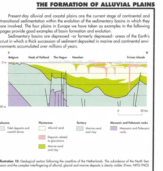
THE FORMATION OF ALLUVIAL PLAINS
Present-day alluvial and coastal plains are the current stage of continental and transitional sedimentation within the evolution of the sedimentary basins in which they are involved. The four plains in Europe we have taken as examples in the following pages provide good examples of basin formation and evolution.
Sedimentary basins are depressed - o r formerly depressed- areas of the Earth's crust in which a thick succession of sediment deposited in marine and continental envi
ronments accumulated over millions of years.
s N
Belgium Hook o f Holland The Hague Haarlem Frisia n Islands
0 m
750 m '
0 50 km
1 _________________ 1
Holocene Pleistocene Te rtia ry Mesozoic and Paleozoic rocks
J Tidel deposits and Alluvial sand Marine sand "1 Mesozoic and Paleozoi
coastal dunes
Deposits related to glaciations j Marine sand
and clay
and clay rocks
Illustration 10: Geological section following the coastline o f the Netherlands. The subsidence of the North Sea basin and the complex interfingering of alluvial, glacial and marine deposits is clearly visible. (From: N ITG -TN O )
The Little Hungarian plain is geologically located in the north-western corner of the Pannonian basin. From Upper Miocene ( 1 1 m years ago) to Recent times this basin accumulated a pile of sediment of more than 5 kilometres. In late Pliocene times (2.5 m years ago), the early Danube river began to supply sediment and water to the basin, beginning the formation of the present-day Little Hungarian-Vienna alluvial plain.
The Po plain is located between the Northern Apenine mountain belt to the south and west, and the Alps to the north; to the east it faces the Adriatic Sea. The Po alluvial plain is fed water and sediment by the Po river. Geologically speaking, the Adriatic Sea and the Po plain are two parts of the same sedimentary basin. Its current evolutionary stage started during Pliocene times (6 m years ago). Since then, the Po-Adriatic basin has accumulated a pile of sediment of up to seven kilometres, and thus it is one of the
youngest foreland basins in the world.
17
The Emporda plain is a narrow alluvial and coastal plain located in the north
eastern corner of Spain. It corresponds to one of the present-day emerged areas of the Western Mediterranean basin, which evolved as a whole from Early Miocene (20 m years ago) to Recent times. During this period the Emporda area accumulated almost 1 0 0 0 metres of shallow marine and continental sediment. Its current evolutionary stage as an alluvial and coastal plain started during Pliocene times (6 m years ago), when the main rivers deposited their early deltas. Since that time, the Daro, Ter, Fluvia and Muga rivers have been responsible for the growth of the Emporda alluvial plain, by feeding it with water and sediment.
The present-day alluvial plain of the Netherlands is the emerged area of the la r
gest delta complex in north-western Europe. The in itia l deltas and alluvial plains came into existence from the end of Tertia ry times. The alluvial deposits came from both the Rhine-Meuse system, coming from the south-east, and a system with an eastern provenance. The first alluvial deposits of the Rhine and the Meuse were con
fined to the so-called Ruhr Graben, an extension of the major Rhine Rift System. Later, from the early Quaternary onwards, the deltas and alluvial plains of both systems extended towards the north-west into the subsiding North Sea basin. Now they are located at a great depth in the subsoil. From about 1 0 0 0 0 0 0 years ago, eastern provenance of sediment ceased, and the Rhine became the dominant supplier of allu
vial deposits. During the Te rtia ry and Q uaterna ry periods sea level fluctuations strongly influenced alluvial deposition in the marginal areas of the deltas and alluvial plains. The Quaternary sea level fluctuations are related to climatic variations, resul
ting in glacial-interglacial periods. During glacial periods (Ice Ages) the alluvial sedi
mentation was repeatedly interrupted by glacial deposition in the northern part of the Netherlands.
18
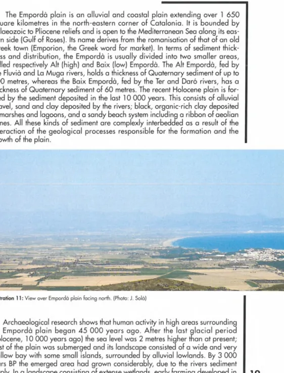
EMPORDÄ PLAIN
The Emporda plain is an a llu via l and coastal plain extending over 1 6 5 0 sq uare kilo m e tres in the no rth-ea stern corner of Catalonia. It is bounded by Palaeozoic to Pliocene re liefs and is open to the Mediterranean Sea along its eas
tern side (Gulf of Roses). Its name derives from the romanisation of that of an old Greek town (Em porion, the Greek word fo r market). In terms of sediment thick
ness and d istrib u tio n , the Em porda is u su a lly divided into two sm a lle r area s, called respectively A lt (high) and Ba ix (low) Emporda. The A lt Emporda, fed by the Fluvia and La Muga riv e rs, holds a thickness of Q uaternary sediment of up to 1 0 0 metres, whereas the B a ix Emporda, fed by the Ter and Daro riv e rs, has a thickness of Q uaterna ry sediment of 6 0 metres. The recent Holocene plain is fo r
med by the sediment deposited in the last 10 0 0 0 years. T h is consists of alluvial gravel, sand and clay deposited by the riv e rs; black, organic-rich clay deposited in marshes and lagoons, and a sandy beach system including a ribbon of aeolian dunes. A ll these kinds of sediment are complexly interbedded as a result of the interaction of the geological processes re sp o n sib le fo r the form ation and the growth of the plain.
Illustration 11: View over Em porda plain facing north. (Photo: J. Sola)
Archaeological research show s that human activity in high areas surrounding the Em po rd a p la in began 4 5 0 0 0 y e a rs ago. A fte r the la st g la c ia l p e rio d (Holocene, 10 0 0 0 years ago) the sea level was 2 metres higher than at present- most of the plain was submerged and its landscape consisted of a wide and very shallow bay with some small isla nds, surrounded by alluvial lowlands. By 3 0 0 0 years BP the emerged area had grown considerably, due to the riv e rs sediment supply. In a landscape consisting of extense wetlands, early farming developed in
19
settlements located along the periphery of the alluvial plain and on some islands.
Some 4 0 0 ye a rs later, a m aritim e trading expedition of G reeks landed on the coast of the Emporda, built a town (Emporion) and a harbour near the mouth of the Ter river, and started trading. The town grew in the Roman epoch (2 1 8 B C -5 0 A D ), reaching a population of 5 0 0 0 inhabitants in its period of maximum splen
dour. By 5 0 A D , the harbour had become almost completely silted up by sediment from the discharges of the Ter rive r and the geological coastal processes related to the progradation of the plain. A s the coastline had reached a position close to that of the present day, the sands blown by the northern w ind (the Tramuntana) from the beach to the south began to invade the town. T h is formed a dune field, which ended up by covering the city, forcing its last inhabitants to d efinitively abandon their homes.
A s in other alluvial and coastal plains, human activity has strongly modified the appearance of the Emporda plain in the course of its recent history. The cour
se of the Ter riv e r and its mouth have been repeatedly altered since the M iddle Ages due to political and m ilita ry confrontations, and several marshes and lakes were drained fo r agricultural and farm ing purposes until the ea rly years of the present century. M ore recently, the tourist boom which started on the coast of the Emporda in the 1 9 6 0 s and which means that the population is tripled in summer, and modern in d u stria l and a gric ultura l methods have stro n g ly contributed to human development of this area. However, this development also leads to other consequences at ground level and more especially in the subsurface sediment containing the a q u ife rs and form ing the plain itse lf. These consequences are m ainly related to the use of new chemical products in modern farm ing, to ground- water production, to production of sands, gravels and clays from the banks of the rive rs and to waste disposal sites. A solid knowledge of geology, gained by detai
led geological mapping and subsurface methodologies, is therefore essential in order to control and m inim ise these problems, and to develop appropriate pre
diction tools. An area of wetlands, still preserved as a natural site and illustrative of the appearance of the plain during the ea rly and middle times of its human colonisation, w ould be greatly favoured by th is knowledge, which wou Id al so guarantee the geological heritage of the Emporda plain.
20
THE LOWER RHINE ALLUVIAL PLAIN
The lower Rhine alluvial plain
For m illions of years the greater part of the Netherlands has been subsiding, in the last 100 0 0 0 years locally at the rate of 1 cm /100 years. As a result, sediment from different periods has piled itself up. From about 2 0 0 0 0 0 0 years ago the dominant facies of th is sediment changed from m arine to a llu v ia l deposits. From about 1 0 0 0 0 0 0 years ago the Rhine became the main source of sedimentation.
Since the onset of the Quaternary, 2 4 0 0 0 0 0 years ago, climatic changes have occurred, and glacial periods ("ice ages") have alternated with interglacial periods.
Related to these climatic changes, sea level fluctuations have occurred: in glacial periods the sea level was low and large parts of the North Sea area were dry: the Rhine created wide incised valleys, which were consequently filled with sand.
During at least two glacial periods land-ice masses that came from Scandinavia covered the northern parts of the Netherlands, and ice-pushed structures, tills and flu- vioglacial deposits were formed.
During interglacial periods the sea level was the same level as nowadays and marine deposits were deposited in the coastal zone of the Netherlands.
As a result of these processes, the alluvial Quaternary deposits are intercalated by marine and glacial deposits.
The complete Quaternary sequence of marine, glacial and alluvial sediment can be as much as 6 0 0 metres in thickness.
Holocene deposits
Dune and beach deposits | [ Alluvial deposits and peat , Lagoonal, estuarine and tidal flat deposits, F /] Alluvial deposits
locally covered with peat
Pleistocene deposits /] Pleistocene
deposits
Illustration 12: Geological map of the Netherlands. (From: N ITG -TN O )
21
The recent deposits cover about 50% of the land-surface of the Netherlands. The sediment thickness increases towards the west to about 3 0 metres.
The sedimentary wedge related to the Holocene alluvial plain is composed of com
plex structures of fossilized sandy river channels bedded in thick alluvial clay deposits and peat layers.
The drainage and cultivation of the alluvial plain started in about 2 0 0 0 BP. The cul
tivation of peatlands started in about 1000 AD. As a result of the cultivation and d ra i
nage, the land-surface started to subside. Subsidence in the peat areas can be in the order of 1 cm/year. As a result, most areas in the western part of the alluvial plain and in the coastal plain, with the exception of the coastal dune belt, are situated about 1 metre below the mean sea level (NAP).
RYINARVM ARC IS B R IT A N N JC Æ APVD BATAVO S T Y P V S . f i M M ^
|7ûtfxnafaàp Castri
[O'.tsm .mndatipru afxrtfjw-J:ibù
S
es, rwùra,jmritnta. nuise, jtfmratajrStrihfuttJivL nui ïipfiarJonm Gina.IWaflenasr,^ rtimnvm faurv
MtP. CAES• L. .SEPTIAUVS S y r . ATJ.T5Jtf-AOa.fW. MWJN V-Î CÆtf.COH.XV. VOX.. ARM KSAVM. v zv stx b. . CON.A - - - ---SVn VA-
FSS?
*r&a/ swafttfi
If.TRIBjOTTmiOSJOTEEIMP.ni ] fAM-AWOCXAVflro EX PafTEA
ffevERO FAXKESVO .XEfnT\TAM] fENOlO-R.
Illustration 13: Engraving made by Abraham O rtelius (1581) showing in birds eye view the coast o f Holland near Katwijk. Here the main branch of the Rhine once debouched flown into the N orth Sea. Due to coastal processes and human interference with the drainage of the Rhine system the mouth o f the Rhine was silted up after the 12th century A D and subsequently overblown by coastal dunes. On the beach are pictured the remnants of the wes
ternmost Roman fortification o f the Limes which was situated on the Rhine delta. Due to coastal erosion and subse
quent retreat of the coastline these remnants are now located in the N o rth Sea over 5 0 0 metres o ff the coast.
(From: N ITG -TN O )
Large parts of the thick peat layers in the western part of the alluvial and coastal plain have been excavated, and the remaining lakes have been reclaimed since the seventeenth century. In these polders the land-surface may be 5 metres below the mean sea level.
From 1 000 AD the first dykes were constructed. As the water level of the rivers and tidal channels in the alluvial and coastal plain is in a higher position than the surroun-
22
ding ^an<^ su rface, dyke bursts have been a regular phenomenon since then.--- A l l u v i a l p l a i n ---
Lowland river Reclaimed lake
Holocene Pleistocene
1 | Alluvial clay 1' j Peat | | Alluvial sand [ | Water
^ Alluvial sand \_ j Marine clay 1 i Wind blown sand
Illustration 14: Geological section showing the complex character o f the Holocene deposits at the transition of the alluvial and the coastal plain. Due to subsidence related to compaction and oxidation o f the peat, land su r
face is now located at about 1 metre below mean sea level. In reclaimed lake areas, were peat is excavated a n d /o r eroded, land surface can be up to over 5 metres below mean sealevel. (From: N ITG -TN O )
To control water level in the polders and to maintain the dykes, since the Middle Ages water boards have been established, which are in charge of the regulation and organization of the local drainage of the polders.
Inhabitants have to pay special taxes to maintain these organizations
Due to the fact that the Holocene coastal and alluvial deposits are for the larger part composed of peat and clay, almost all building constructions need foundation pillars in the underlying Pleistocene sands. Old constructions have wooden pillars (it is said that the seventeenth century Amsterdam town hall is built on top of over 10 0 0 0 wooden pillars). For recent family houses foundation costs (concrete p illa rs with a length of 1 2 metres) amount to 5 -1 0 % of the price of the houses.
The construction of highways and railways is extremely expensive, since, as a rule, sandy dykes need to be constructed to support roads and rails.
A s a result of the increasing population density and decreasing availability of space, underground building and tunneling are receiving more and more attention and expertise is generated.
Although the Netherlands has an abundance of water, the amount of fresh water available is limited due to the high level of salt water in the subsoil of the coastal zone and local contamination. Infiltration of fresh (river) water in the coastal dunes provides an excellent substitute for a natural fresh water reservoir
23
THE LITTLE HUNGARIAN PLAIN
The Little Hungarian plain (Kisalföld in the Hungarian language) is a 6 0 0 0 squa
re kilometre depression located in central Eastern Europe, fed by the River Danube (Duna in the Hungarian language) and its tributaries (Rábca, Rába, Lajta and Marcal).
W ith a total length of 2 9 0 0 kilometres, from its sources in the Black Forest in Germany to its delta on the Romanian coast of the Black Sea, the Danube is the oldest and the second longest river in Europe.
The landscape of the Kisalföld is that of the typical Hungarian steppe (the puszta), with large areas of wetlands, although most of them have been recently drained for agricultural purposes.
24
Illustration 15: A irv ie w o f the Danube valley northw ard from Györ, Hungary. (From: M A FI)Due to its geo-strategic location, throughout history the Hungarian plains have been served as a backdrop for large forced or voluntary migrations and military operations.
The Romans occupied the right bank of the Danube (Pannónia) in 10 AD and Dacia in 107 AD. A s it was the northern border of their empire, they fortified the Danube against the barbarian tribes. The legions of Augustus, Attila, Charlemagne, Napoleon, the Ottoman Turks, the Austrian Habsburgs, Hitler and Stalin all marched along its banks.
Geologically speaking, the Kisalföld is an interior plain surrounded by the Carpathians to the north and to the east, by the Dinaric Alps to the south, and by the Eastern Alps to the north-west. It is about 4 0 0 km from north to south and 8 0 0 km from east to west.
The River Danube made its appearance in the Little Hungarian plain at the end of the Pliocene (so-called Pannonian; 2 .5 m years ago), accumulating up to the Mindel- Riss interglacial period of the Pleistocene (0.25 m years ago) an enormous alluvial fan.
Since Middle-Pleistocene times (0.13 m years ago), the central and northern parts of this fan have subsided intermittently, whereas its southern sector has been uplifted, resulting in the formation of terraces along the Danube. Sediment forming the ancient (Pleistocene) alluvial fan has been therefore preserved on the Parndorfer-plateau in A u stria , as well as on the highest ranges of the Györ-Tata Terrace Land. During
Illustration 16: Q u a te rn a ry sediment shown by the surface geological map. Scale 1 :1 0 0 0 0 0 , K isa lfö ld ,
Hungary. (From : M A FI)
25
Holocene times the Danube deposited a new alluvial fan. Th is younger sediment lies over Pleistocene deposits in the core of the new fan, whereas in other parts of the sy s
tem they are found side by side. Geological maps show how the sediment forming the youngest sequence in the evolution of the Danube's alluvial fan in the Kisalföld mainly consists of fluvial gravel, sand and clay deposited in a spectacular meander belt which can be observed in Szigetköz. Peat layers and dark organic mud are deposited in paludal areas and in oxbow lakes formed in abandoned meanders.
Since river regulation undertaken in the last century, the large amount of sediment trans
ported by the Danube has accumulated in the area confined by flood-protecting dams, resul
ting in the gradual elevation of the sediment's level. From recently acquired well and geophysical data, it is known that the total thickness of Quaternary fluvial sediment overlying the marine Pliocene deposits ranges between 38 and 700 m in this part of the Danube.
100
50
0
-50 -100
Holocene flood plain sediment | j Pleistocene fine gravel and sand | | Pleistocene silt
Pleistocene course gravel | j Pleistocene clay | | Pliocene basement
Illustration 17: Geological section o f the Danube's alluvial fan. Kisalföld, Hungary. (From : M A FI)
The absence of loess deposits and the erosion of old forestal soils make the agri
culture in the Little Hungarian plain less productive than the agriculture in the Great Hungarian plain (Nagyalfold). However, some 8 0 0 square kilometres have recently been drained from lake Fertô for agricultural purposes. Apart from the potential hydro
carbon reservoirs in its deeper subsurface, the most important resource for the life of the Little Hungarian plain is the groundwater stored in its aquifers
26
THE PO PLAIN
The Po plain (Pianura Padana in the Italian language) is the alluvial plain along which the River Po and its tributaries flow. It is surrounded to the north and west by the Alps and to the south by the Northern Apennines, while to the east it opens out to the Adriatic Sea. W ith a total area of about 30 0 0 0 square kilometres, the Po plain is the largest alluvial plain in Western Europe.
Illustration 18: Typical landscape of the Em ilia-Romagna alluvial plain. (Photo: P. Severei)
The landscape of the Po plain is extremely varied. Its northernmost parts feature landforms and deposits of glacial and fluvial-glacial origin. They consist of gravel deposits. In its southern areas, such as the low -lying plain of the Emilia-Romagna Region, the landscape of the Po plain is typical of an alluvial plain, with higher zones (the channels and levees of the main rivers) and lower zones (the areas between the rivers, known as interfluvial basins) which, until they were gradually drained by man over the centuries, were often flooded and thus uninhabited. The coastal area shows the typical landscape of the Po delta, with distributary channels and generally flooded bays between them, where the river waters merge with those of the Adriatic Sea. Both to the south and to the north of the delta there are vast sandy beaches which once had dune systems. Unfortunately, these are virtually invisible nowadays, because they have been flattened to make way for roads and holiday resorts. The zone of the lagoon of
27
Venice is extremely important, not only because of its highly unusual landscape, but also due to the great artistic and historical value of the town of Venice itself.
From the geological point of view, the materials in the shallow subsurface of the Po plain consist of alluvial sediment accumulated by the discharges of the Po river and its tributaries over about one million years. The thickness of this alluvial sediment ranges from a few tens of metres up to several hundred metres. They record the final phase in the filling of a large basin between the Alps and the Apennines, which started to form several millions of years ago. In this period, the area where the Po plain is now was covered by a sea a few hundred metres deep, in which sand and clay were deposited.
The bottom of this sea gradually became lower and lower due to tectonic subsidence, and this allowed the continuous accumulation of new sediment over geological time, while the oldest sediment gradually sank to greater and greater depths.
In many parts of the Po plain the processes of subsidence are still active, and it is quite common to find Roman remains (villas or roads) some 2 2 0 0 years old, buried under several metres of alluvial sediment.
Illustration 19: Geological map o f the Em ilia-Romagna Po plain. (From : U G ER)
W ith the passage of geological time, the deepest marine sediment, now lying seve
ral thousands of metres below the surface, has trapped and stored hydrocarbons (par
ticularly methane), which are currently being extracted to meet some of Italy's energy requirements. The overlying, shallower alluvial sediment (from ground level down to about 3 0 0 -4 0 0 metres) constitutes an immense reservoir of fresh groundwater, which is widely used to supply drinking and other water needs of the population of the Po plain.
Since ancient times, and thanks to the large quantity of water that is easily availa
ble, the lush vegetation and the* flatness of the land, the Po plain has been the site of human settlements. The first signs of human presence are thought to date back to as early as 5 0 0 0 0 0 or 6 0 0 0 0 0 years ago (late Stone Age), as has been proved by the finds of flint tools of this age. Moving to times much closer to our own, the Romans con
sidered the Po plain to be an area of great interest because of its enormous potential for agricultural production and its strategic location as a base for the conquest of Northern Europe. After the m ilita ry occupation of the plain (third century BC), the Romans deforested and drained the land for agricultural purposes and constructed an
efficient road network. The system they used to drain the land consisted, at least from 109 BC, of the construction of dense networks of canals. The benefited lands were divi
ded into plots by means of a squared network of 7 1 0 m each side, following an old Greek and Etruscan model they called Centurisation. These plots were then allocated to the veterans of war for their cultivation. Its is interesting to note that the Centurisation is still recognisable in the Po plain, since today's road network is strictly superimposed on the old Roman one. Its paving and the one o r more arched stone bridges made the Roman road network the most advanced in the world at that time. Moreover, the layout of the Via Emilia, constructed by the consul Marco Emilio Lepido in 1 87 BC, remains one of the main communication routes in the Po plain today. From their establishments and infrastructures, the Romans built or expanded almost all the plain's principal cities (Milan, Bologna, Ravenna, etc.).
Today, the Po plain is one of the most densely populated areas of Italy and Europe;
big cities and large industrial complexes alternate in a landscape dominated by highly specialised agriculture, while the Adriatic coasts boast some of Europe's oldest and most famous seaside resorts. A ll these factors make the Po plain a zone with a high per capita income.
On the other hand, such intensive human activities obviously pose some problems with regard to their effect on the natural environment of the Po plain. The main pro
blems involve the pollution of the ground and the fresh water (surface and ground- water), as well as the salt water of the Adriatic Sea, and the gradual deterioration of the aquifers caused by agriculture and industry more or less right across the Po plain.
Although its causes have not yet been fully explained, the eutrophisation of the Adriatic Sea in the summer of 1 9 8 9 was certainly aggravated by the large amounts of nitrogen compounds used in agriculture and then carried to the sea by the Po.
29
CONCLUSION
Alluvial plains grow and change their appearance through time, due to the inter
action of intrinsic and extrinsic factors controlling erosional and depositional processes along the entire fluvial systems, from the drainage basins to the final depositional areas. Any change in these factors occurring in any part of the system w ill result in undesirable changes elsewhere in the system. Th is is very important, because major alluvial systems often cross international boundaries.
Management of the alluvial plain resources include water management, wetlands management, coastal zone management, management of aggregates, town planning, control of pollutants in aquifers, building activities both on the surface and in the sub
soil, and subsidence studies.
The complex investigation of alluvial plains aimed at their protection and the pro
tection of the ground water stored in their aquifers, imposes a certain financial burden on the various states. However, investments can swiftly be recovered, for instance by the cost of healthy drinking water exploited as a result of the surveys. And the geologically accurate selection of suitable sites for storing communal and industrial waste generates a benefit that exceeds the amount of related expenditure.
A thorough knowledge is therefore needed of the geology and the lithology of the alluvial plain architecture, both at the surface and the subsurface and of the fluvial fee
ding systems and the drainage basins. National and regional geological surveys can provide this knowledge. Basic information is published on geological maps. More spe
cific geological information can be provided on request on the basis of available data
bases and knowledge. However, further international studies are needed to produce management models for decision makers.
Knowledge about the land and what lies beneath it is therefore essential for its pro
per use.
30
31
Estimated mean ju ly temperatures (The Netherlands)
Illustration 21: Diagram showing the relationship between the influence of human activity and historical time. (From: ICC.SGC)
Palaeomagnetic timescale
| Normal polarity I I Reversed polarity
Palaeotemperatures based on pollen analyses I | Warm
Illustration 22: Palaeomagnetic timescale and estimated temperature curve o f the Q uaternary based on palynological data of the Netherlands.
(From: N ITG -TN O )
32
9