125
years
Hungarian Geological
Survey
Studies
HUNGARIAN GEOLOGICAL SURVEY
BUDAPEST 1994
ÁRON JÁMBOR
Translation from Hungarian into English by ANNAMÁRIA NÁDOR
OTTÓ TOMSCHEY GYÖRGY VECSERNYÉS
SÁNDOR VÉGH English text reviewed by
ENDRE DUDICH GÁBOR GAÁL WILLIAM HEINES
TAMÁS JASKÓ Edited by ÁGNES TÓTH-MAKK Reference üst compiled by
OLGA PIROS Technical editing by
DEZSŐ SIMONYI
Preparation for printing on DTP by ILDIKÓ TIEFENBACHER with use of PROFONTS LIBRARY fonts
Published by
Geological Institute of Hungary Hungarian Geological Survey
Director GÁBOR GAÁL
Sponsored by Pátria Printing Co
ISBN 963 671 164 x
Printed by Grafika Ltd Co
Manager:
FOREWORD
The 18th of June, 1869 is of outstanding impor
tance in the history of the Hungarian geology in as well as in the whole world. The King of Hun
gary Francis Joseph I signed the Deed of Foun
dation of the Royal Hungarian Geological Insti
tute on this day. By this royal act the Hungarian Geological Survey began its activities - as being the first scientific research institute of the Hungarian state and as one of the earliest foun
dations of this kind also all over the world (Böckh&Szontagh 1900, Nelson 1994).
The fundamental tasks of the Survey were specified by the Deed of Foundation along the following lines:
(a) detailed geological survey of the Lands of the Hungarian Crown is to be carried out, along with the publication of the results obtained corresponding to the demands of the science, agriculture and industry;
(b) geological maps of the territory of the Hungarian state, both of general and detailed character have to be compiled and published;
(c) petrographical and paleontological collec
tions have to be established in order to demon
strate the formations and their features taking part in the makeup of the territory of the Hungarian state;
(d) chemical analyses of soils, minerals and rocks are to be performed for agricultural, min
ing and other industrial purposes.
Since the 12^ of October 1899 the Survey is housed in the present headquarters. This build
ing being an excellent representative of the characteristically Hungarian "secessionist" style has art historical importance and as such it is held in high esteem all over Europe. It is one of the most important works of Ö. Lechner, a re
nowned architect of the Hungarian "fin de siecle". The building was erected in 1898-1899 by S. Hausmann on the site donated by the city magistrate of Budapest. The financial basis was provided by the Hungarian state and by Mr. A.
Semsey a rich landowner who generously offered a considerable part of the enormous sum of money needed.
During its history the Survey has always been acting in the spirit of the aims formulated in the Deed of Foundation, although in the time elapsed since its foundation many of changes took place as the tasks were modified according to the current demands of the society and the national economy. By serving the science the Survey has made every effort, however, to meet the requirements of everyday life as well.
During the 125 years of its existence there were times of success and those of crisis. The past few years were of the latter. We are living in a period of constrained restructuring and re
form times, of fundamental changes in the scope of our activities, and we are looking for new directions. Doing our work in the frame
work of the new organization set up in 1992 we have to reformulate our tasks and to achieve success bearing the burden of the radical cutback of our staff and of the restrictions in our budget since 1993. Accordingly, we com
memorate the 125th anniversary of the founda
tion amid considerable difficulties.
It is essential, even in difficult times, to com
memorate, and to recall the successes but also failures. We owe this not only to ourselves but to the posterity as well. And it is essential to have days of celebration, because we are proud of our 125 years old Survey, which has achieved
outstanding results in the enrichment of the geological knowledge at home and abroad. We do need the historical retrospection for learning the lesson of the past and for our successful ad
vancement; but we do need also the celebration, in order to strengthen our belief in the impor
tance of our vocation.
We intend to celebrate the 125th anniversary of the foundation of our Survey by organizing an International Conference and a Hungarian Day. The International Conference will be or
ganized in co-operation with ICOGS - the Inter
national Consortium of Geological Surveys - under the auspices of the UNESCO and the In
ternational Union of Geological Sciences. The aim of this Conference is to investigate and to discuss the role of geological sciences in a changing society.
A general introduction by E. Dudich, who will briefly outline the history of the Hungarian Geological Survey, will be followed by talks given by the Directors of national geological surveys on the following topics;
- Geological sciences in a changing society (by A. E. Babcock, Director of the Geological Survey of Canada);
- East-west co-operation in the geological sciences (by G. Gaál, Director of the Geological Institute of Hungary, Hungarian Geological Sur
vey);
- North-south co-operation in the geological sciences (by C. Frick, Director of the Geological Survey of South-Africa);
- Co-operation between geological surveys in Europe (by Ch. Staudt, Director of the Geo
logical Survey of The Netherlands);
- Role of geological surveys in the 21st cen
tury (by P. Cook, Director of the Geological Sur
vey of Great Britain);
- International geological science co-opera
tion - the role of the IUGS (by M. Schmidt- Thomé, IUGS, Treasurer, Bundesanstalt für Geowissenschaften und Rohstoffe, Germany);
- The task and organization of geological sciences in the USSR and in Russia - a compari
son (by V. P. Orlov, President of the GEOLCOM - Russia);
- Highlights of Chinese geology - in view of the preparation of the 30th International Geo
logical Congress (by Zhao Xun, Vice-president of the Chinese Academy of Geological Sciences, China)
The plenary session will be followed by a business meeting of ICOGS, providing the
framework for discussing the following two im
portant topics:
- global co-operation in the geological sciences;
- geological sciences and education.
Prior to the Conference - and as an introduc
tion to it - on the occasion of the field trips to Tokaj and Eger (17 and 18 of September) the participants will have an opportunity to famili
arize themselves with the geology and the wines of two famous historical winedistricts of Hungary.
The patronage over the Hungarian Day has been kindly accepted by His Excellency Árpád Göncz, the President of the Hungarian Repub
lic. This day is dedicated to the presentation of the past 25 years of the Hungarian Geological Survey to the Hungarian audience. The pro
gramme includes the presentation of the follow
ing topics:
An overview of the 125 years of the Hungar
ian Geological Survey (by G. Gaál, Director);
Geological mapping in the past 25 years (by G. Chikán, Head of Division);
Geological basic research in the past 25 years (by Z. Balia, Head of Division);
Stratigraphical results of the past 25 years (by G. Császár, Project-leader);
Mineral exploration in the past 25 years (by J.
Knauer, Head of Division);
Environmental geological research in the past 25 years (by Gy. Tóth, Head of Division).
On the occasion of the Hungarian Day our guests will have the opportunity to get ac
quainted with our Survey. The results of the past 25 years will be visualized by posters and maps, while the history of the Hungarian ge
ology and the earth's history in our country will be presented in a new permanent exhibition which will be opened on this occasion.
The present publication has been compiled on the occasion of the anniversary. In previous publications the first three decades of the Sur
vey's history had been reviewed by I. Böckh and T. Szontagh in 1900; while the studies deal
ing with the first hundred years have been pub
lished in a special volume edited by J. Fülöp and A. Tasnádi Kubacska in 1969. In our present situation we can not afford to publish a decora
tive volume like the mentioned ones, which might contain also a detailed historical over
view. Nevertheless, we present this collection of studies, which gives a brief review of the past 125 years.
In the first part of the volume four papers summarize the most important events of the 125 years of the Survey's history. The studies of the second part are focused on the activities of the recent 25 years, on the results of the important tasks of the Survey. This part contains also the short biographies of the Survey's directors who were in office in the period under consideration. At the end of the volume there is a detailed list of references in which the published papers and unpublished manuscripts referred to by the authors have been compiled. In this bibliography the empha
sis has been on the publications reporting on the most important achievements of the past 25 years.
I have the honour to recommend our present publication to readers of the present time and of the future in Hungary and abroad, both to our colleagues and to all those who are interested in the activity of our Survey. We hope that we might do our work under more calm and more orderly conditions in the coming times serving the inter
ests of the society and the economy of Hungary, and the development of geological sciences both at home and on the international scene. If our hopes come true, the authors will report on more success and less problems in the volume to be edited on the occasion of the next anniversary.
Gábor Gaál Director
1 8 6 9 — 1 9 9 4
HISTORY OF THE HUNGARIAN GEOLOGICAL SURVEY FROM 1869 TO 1919
by KÁLMÁN BALOGH
According to its Deed of Foundation, signed by the king, the Institute is expected to perform the following main tasks: (1) Small-scale and large- scale geological mapping of the national terri
tory extending to 325 000 square kilometres with the inclusion of Croatia and Slavonia. (2) The issuing of publications on the survey re
sults for the scientific, agricultural and in
dustrial life. (3) The establishment of a map depository, a technical library and a geological museum containing collections of minerals, rocks and fossils suitable for comparison. The above were expected to secure a continually high standard of geological work to awaken the interest in geology of the general public, making thereby the geological sciences popular, and making the Survey better known and more respected both in the country and abroad.
At the time of foundation (1869), director
Miksa Hantken could count upon the assistance of only three geologists graduated in Vienna and/or at Selmecbánya (J. Böckh, K. Hofmann and B. Winkler), in company of two assistant geologists trained at the Budapest University under the professorship of József Szabó (L. Tel- egdi Roth and D. Gaai), with two more geolo
gists contracted from Erdély (Transylvania), namely F. Herbich and E. Pávay. The number of experts remained unchanged till 1882, but then
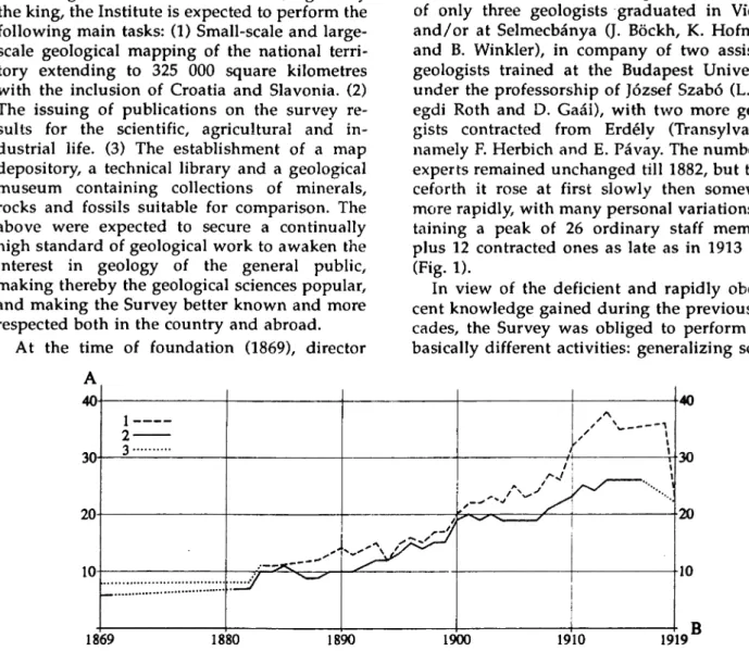
ceforth it rose at first slowly then somewhat more rapidly; with many persona! variations, at
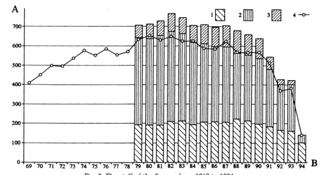
taining a peak of 26 ordinary staff members plus 12 contracted ones as late as in 1913 only (Fig. 1).
In view of the deficient and rapidly obolcs- cent knowledge gained during the previous de
cades, the Survey was obliged to perform two basically different activities: generalizing scien-
Fig. 1. Variation of the number of geologists on the staff of the Hungarian Geological Survey between 1869 and 1919
Continuous line marks the number of permanent staff members, broken line shows the number of permanent members plus outside contributors.
Dotted line indicates lacking data
tific research and practical expertises locally re
quired by the everyday life. The quickly developing economy brought about an increas
ing number of practical tasks hindering thereby the progress in country-wide geological map
ping and material testing. Both Hantken and his successor, J. Böckh made unsuccessful attempts to increase the number of geologists and to differentiate the fields of work. All in all, 14 and 22 years, respectively, after the Survey's founda
tion, it needed a good deal of manage for J.
Böckh to set up the following separate depart
ments: (a) a Mining-Geological Department to study of regions of ore mineralization in Upper Hungary and in Erdély (Transylvania), (b) a Chemical Laboratory attending internal and ex
ternal claims of the sort and (c) an Agrogeologi- ca! Department to deal with the soils of the Great Hungarian Plain.
The economic life required the assisstance of the Survey in accomplishing the following tasks: marking of the tracts of the road and rail
way system; exploration of coal and metallic mineral resources; search for occurrences of construction materials and ornamental stones;
exploration of water for drinking and industrial use; medicinal water supply; problems of river regulation; examination of ground slumping and landslides, and questions relating the pro
tection against the phylloxera plague and solodization. This manysided work was done official or private expert reports according to the kind of claimant (governmental institutions, private individuals or private venturers). The sphere of activities was further widened by the Water Law coming into force in 1885 wl^ich vested the Survey with the power to issue offi
cial expert opinions, which had to be applied for prior to commencing any action in the con
cerned field. In 1894-1895, at the request of the Minister of Finance, J. Böckh investigated the hydrocarbon problems of Iza-Valley and Sósmező in Szekler Land, T. Posewitz did the same in Körösmező (Jaszinya) and L. Telegdi Roth dealt with ozocerite of Zsibó (Jibou). The asphalt-bearing lignite deposits at Derna and Tataros (Brustura) in the Réz Mountains were also studied (Telegdi Roth 1923).
In 1908, plans of prospecting for potassium salt and natural gas resources in Transylvania demanded the setting up of a Department of Applied Geology in the Survey. In 1910, however, upon a proposal made by L. Lóczy Sr.
the task of hydrocarbon exploration was trans
ferred to the Geological Department created in
side the Ministry of Finance. Thereafter the ex
ploratory work performed by the Survey was marked mainly by the study of M. Palfy (1911), on the mines of the Transylvanian Ore Moun
tains (Erdélyi-érchegység, Mtii Metalliferi), the work of K. Papp (1915) entitled "The iron ore and coal resources of the Hungarian Empire", the discovery of manganese ore of Úrkút in Transdanubia and the study of the bauxite of Királyerdő (Padurea Craiului) in Transylvania are also mentionable (Rozlozsnik 1917, 1918).
Anyhow, on account of the practical tasks as
signed to be accomplished by the Hungarian ge
ologists, the results of geological mapping exe
cuted simultaneously have been left behind in concise reports only. Only a few authors of the more voluminous publications (Hantken 1878, Hofmann 1871, 1873, 1875, Böckh 1872, 1875 a, b, and 1877, Telegdi Roth 1883, Schafarzik 1892) were staff members of the Survey participating in the first major scientific venture, the geologi
cal mapping of Transdanubia. The authors of the majority of major publications were as
sociate members, foreign scientists and special
ists dealing with late Tertiary faunas (Pávay 1875, Herbich 1878, 1886, Staub 1882,1883,1887, 1891, Heer 1877, Halaváts 1890a, b, 1892, 1894, 1895, 1896, 1904, 1912, 1914, Felix 1884, 1890), and even some mineral prospectors (Schafarzik 1904, Kalecsinszky 1893, 1901, 1905).
The publishing process was also kept back by the fact that no author's royalties were paid.
Since their salaries were low, geologists became more interested in producing well-paid expert's reports than in the compilation of monographs and explanatory notes to maps. Furthermore, most of them preferred the quick megascopic methods in petrological and palaeontological determinations to the onerous tasks using more sophisticated methods. Despite its great practi
cal usefulness, the microscopic method prac
tised by Hantken was adopted only by an as
sociate member, Á. Franzenau (1881), though Hantken was a pioneer of stratigraphic micro
palaeontology who recognised the dimorphism (A and B generations) of the nummulites. The petrological microscope was disregarded by J.
Böckh and even by the mining geologist S.
Gesell, and was introduced as an indispensable too! of the study of igneous and metamorphic rocks only by K. Hofmann (1879, 1886), F. Scha
farzik (1892), B. Inkey (1883) and Gy. Primics (1883, 1889).
The main strength of the geologists in the first 38 years lay in their profound knowledge
developed under the influence of the German school (A. G. Werner, L. v. Buch, E. A. v.
Schlotheim, F. Au. Quenstedt, H. G. Bronn, W.
Haidinger), based upon good observation abil
ity/ Due to this, the sedimentary deposits of Hungary ranging from the Devonian up to the Quaternary were dated correctly in the main.
Because of the poor knowledge relating to metamorphism at that time, the genuine nature of these rocks remained unclear for long, however, the personal obstinacy of J. Böckh also played a role in the coming about of this setback.
After its foundation, the Geological Survey set out to survey Transdanubia, a region which had been neglected geologically. The mapping, in general, was aimed at the plotting of sheets joining the maps completed by Viennese geolo
gists in 1869 to depict the Carpathian region to the Visegrád-Bükk Mts line. Geological maps were plotted on scales of 1:28 000 and 1:144 000, respectively. Only the "General Map of Transyl
vania" of F. Herbich had to be prepared as a more generalizing one. The 1:25 000-scale and 1:75 000-scale, hachured military maps were printed only in the late 1870's. All the former geological observations had to be re-visualized, of course, by the geologists, on these new ordi
nary topographic maps. Despite this, the map representation of Transdanubia was almost en
tirely completed by 1883, so the 1:144 000-scale geological map of this region of Hungary could be displayed at the National Exhibition of 1885.
Difficulties appeared when the surveying of the regions of the western boundary mountains of Transylvania and of the NE Carpathians was started in 1877. Hardships presented by the very nature of high mountains such as the great differences in altitude, the severe climate, the loneliness of the mountain woodland as well as the inaccuracy of the topographic map bases re
quired extraordinary efforts of the geologists working for months under such conditions.
Some of them drew back from the work, and left the Survey. Others, for example Gy. Pethő and K. Hofmann who was unsurpassable in precise mapping, were taken ill and died too soon, whereas the very talented Gy. Primics met his death during fieldwork. The progress of work was slowed down by the resulting changes in personnel. Other kinds of inconvenience also emerged. Resulting in a spiritless work, it was
norm prescribed for the completion of fielfd- work in a map-sheet area, irrespective of whether it is possible with regard to the areal extent of the geological units and to the prob
lems involved. Sometimes the willingness of the mappers was lacking to fit together the in
dividual map sheets. These problems had al
ready been encountered when mapping Trans
danubia, however, they became accentuated in the high mountains. Geologists had a minimum chance to specialize in any topic, since between two periods of field work, in wintertime, they were unable to process even their own rock samples and fossils collected during the map
ping. Accordingly, only brief survey reports were written, and the publication of the ex
pectable summarizing studies was retarded. L.
Lóczy Sr. (1909) complained that the Survey was bound to publish 3 to 4 dozens of 1:75 000- scale map sheets with appropriate explanatory notes and only 19 volumes of the Annals ap
peared in forty years.
The geological museum, starting from scratch, was gradually enriched by the findings of mappers, private persons and companies, and also from the donations of the great Mae
cenas, Andor Semsey. Educational purposes were served by providing schools with didactic collections of minerals, rocks and fossils for.
The stock of the library was developed through an international exchange of publications, be
sides purchase and donation.
The results of mapping and material testing were first published exclusively in the Bulletin of the Hungarian Geological Society (Földtani Közlöny). As late as in 1871 the Survey com
menced to issue the Annals, and in 1881 the An
nual Reports. To the geological maps printed on a scale of 1:75 000, explanatory notes were also attached. Information on applied-geological ac
tivities, moreover museum and library news were published in the form of Occasional Papers. These publications and the participation in international congresses and exhibitions made a name for the Hungarian Geological Survey.
Although the fundamental merits of the first 38 years have to be acknowledged, the wrong research strategy leaves its mark on the whole period. The serial production of map sheets ac
cording to a chessboard-like system, in itself a tool only, was taken for the principal aim in-
The results in stratigraphy of the Hungarian geologists are dealt with in K. Balogh's paper (1993) in detail
stead of a systematic study of geological prob
lems. The geological knowledge of the areas once mapped was not consecutively improved, and their summarizing description was not fostered. No serious step was taken to start a geological reconnaissance of the NW Carpathi
ans and Croatia-Slavonia.
In 1908 J. Böckh was followed in the director
ship by L. Lóczy Sr., who had already made a name by his investigations carried out in Middle Asia and in the Balaton Highland. Lóczy Sr. intended to improve the above-described sit
uation by setting the preparation of geological syntheses as a principal goal. Although he chose himself to bring the project to a successful con
clusion, nonetheless he allowed his colleagues to co-operate by describing monographically, in a manysided manner, each natural geological unit, and arranged for proper royalties to be paid after the job had been done. An up-to-date research approach was required, with strati- graphical analysis followed by the reconstruc
tion of paleogeography, tectonics and evolution- historical events, including the outlines of geo- morpholcgica! evolution. Lóczy directed and
stimulated this work by making frequent visits in the field and by the unselfish transfer of his long experience to fellow researchers. Ensuring a long-term financial background, he doubled the number of the members of the permanent staff, and increased the number of the outside contributors even higher than shown in Fig. 1.
Some prominent foreign scientists and Hungar
ian secondary school teachers were also drawn into the work.
At his nomination, in 1908, Lóczy Sr. was al
ready fifty-nine, when he boldly undertook to implement his plans. First of all, he envisaged the completion of the works launched by Böckh in the Southern Carpathians, Bihar Group, Transylvanian Ore Mts and in the NE Carpathi
ans, by a modern approach. However, re
searchers were sent simultaneously to the fol
lowing regions, too: Bán Mts, Villány Mts, Mec
sek Mts, the Alps where extending as far as into Hungary, the basalt buttes of Kisalföld (the Little Hungarian Plain), parts of the Trans- danubian Centra! Range, Cserhát, Salgótarján Basin, Mátra Mts, Borsod-Bükk Mts, the princi
pal parts of the Eastern Carpathians and the
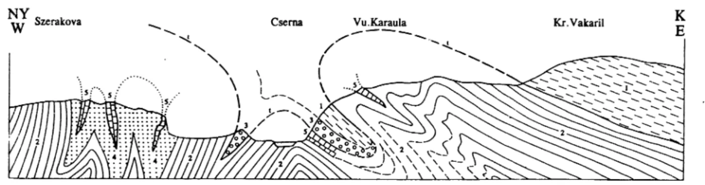
Fig. 2. Geological section across the Ogtarije area with the upthrow of Carboniferous rocks, according to Koch, F. (1914)
1. Upper Liassic mottled limestone, 2. Middle and Upper Liassic, 3. Hauptdolomit, 4. Diplopora limestone, 5. Seisian strata, 6. Permo-Carboniferous, 7. Upper Carboniferous, 8. Porphyrite
Fig. 3. Geological section set to the south of Csemahévíz, according to Schafarzik, F. (1914)
Autochton: 2. Gametiferous gneiss, biotite gneiss, micaceous phyllite, 4. Liassic quartzsandstone, 5. Malm limestone. Units of the nappe: 1. Mica
ceous gneiss, mica schist and pegmatite, 3. Verrucano (Permian)
Fig. 4. Geological section set from Girda-száka towards the north-east, according to Pálfy, M. (1914)
1. Permian limestone, 2. Triassic dolomite, 3. Triassic limestone, 4. Rbaetian-Liassic sandstone with overlying Upper Liassic arenaceous limestone, 5. Dogger, 6. Malm
Fig. 5. Geological section of the eastern side of the Bél Mts (Béli-hegység) according to Pálfy M. (1913)
Lower Permian, P]: Quartz porphyry, P2: diabase and keratophyre, in the 111. Permian range with intercalated violet and grey slate, sandstone, diabase tuff, at places strongly pressed quartz porphyry. Upper Permian, P3: Quartz porphyry tuff and conglomerate, arkosic sandstone, passing upwards into quartzite sandstone; P4: quartzite sandstone. Middle Triassic, T^: Lower dolomite (Anisian), T2: dark grey limestone with grey and yellow slate; Wen- genian strata (Ladinian stage), T3: upper "saccharoidal" dolomite (Camian stage). Upper Trassic, T4: Light and dark grey limestone with red veinlets (Norian stage), R: sandstone, marl, dark grey coralline and brachiopod-bearing limestone (Rhaetian stage). 1: Light grey or red crinoidal and compact
limestone (Lower and Middle Liassic), D-M: grey marl and sandstone (?Upper Liassic, Dogger-Malm), Kv: gravel (Diluvium)
Transylvanian Basin. With seven Croatian and Hungarian geologists involved, the geological survey of Croatia-Slavonia, concerning mainly the Karst Mountains was started in 1911. The re
mapping of the Northern Carpathians was launched in 1913, as a work planned for ten years with the participation of nine mappers. In 1916, taking along twelve men, Lóczy Sr. him
self undertook the small-scale geological sur
veying of West Serbia, Bosnia and East Mon
tenegro.
As a matter of fact, this ambitious pro
gramme turned out to be exaggerated in the his
torical situation of those times. The execution of the plans met with difficulties of different na
ture. The internal troubles of the Austro- Hungarian Monarchy, the outbreak of the First World War, the call-up of numerous geologists, the drawbacks of the work to be performed in
side and outside the Survey, the revolutions in 1918 and 1919, the undeserved personal attacks launched on Lóczy Sr., the downfall of the state consequent upon the military defeat and the
foreign occupation of the country - all these handicapped the researchers and the progress of geological research. On account of his frustra
tions and getting more and more exhausted in a desperate race against time, Lóczy Sr. resigned from directorship on 03. 09. 1919, and half a year later he died. With him, Hungary lost one of her geologists with the widest intellectual horizon.
Yet the first half a century of the Institute can display significant achievements. J. Böckh (1883, 1887), F. Schafarzik (1895, 1914), F. Nopcsa (1905a), B. Inkey (1884, 1885, 1891), Gy. Primics (1883) and A. Vend! (1932) established very well the geological knowledge of the region situated between the Lower Danube and Királykő in the Southern Carpathians. For instance, it was Scha
farzik who distinguished the Lower Carbonifer
ous of Kornareva in a group of phyllites, stating that the concerned unit is unconformably over- lain by Upper Carboniferous beds containing coal seams. Upon microscopic examination he rectified numerous former views (Fig. 3). Scha-
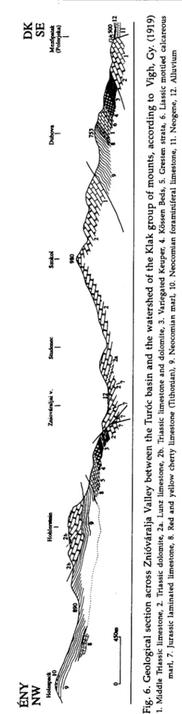
Fig. 6. Geological section across Znióváralja Valley between the Turóc basin and the watershed of the Klak group of mounts, according toVigh, Gy. (1919) L Middle Triassic limestone, 2. Triassic dolomite, 2a. Lunz limestone, 2b. Triassic limestone and dolomite, 3. Variegated Keuper, 4. Kössen Beds, 5. Gresten strata, 6. Liassic mottled calcareous marl, 7. Jurassic laminated limestone, 8. Red and yellow cherty limestone (Tithonian), 9. Neocomian marl, 10. Neocomian foraminiferal limestone, 11. Neogene, 12. Alluvium
farzik evidenced also the Jurassic age of the Schelea Formation. His statements were con
siderably relied upon when the nappe theory re
lating to the Southern Carpathians was elaborated (Murgoçi, 1905).
P. Rozlozsnik (1906 a, b, 1908, 1913), moreover M. Pálfy (1911-1916; Figs. 4 and 5) de
scribed the structure of the Bihar Group (Mtii Apuseni) as a truncated set of nappes. In this, the study of occurrences of continental Car
boniferous rocks around Nagybihar (Cucurbeta) was instrumental, together with that of the dis
tribution of different Mesozoic facies. The dis
tinction of the Vepor and Szepesség nappes is also linked with the name of P. Rozlozsnik (1914-1915). Fossils collected by E. Vadász (1909) indicated the presence of marine Car
boniferous deposits in the Bükk Mountains. The age of calcareous algae described by J. Ja- blonszky (1919), after a due revision, proved the presence of marine Upper Permian deposits - then the only such occurrence in the entire Car
pathian Basin. At that time, rocks of the conti
nental Permian were already widely known in the Balaton Highland, Mecsek and Kodru (Böckh 1872, 1876a, b, Lóczy 1913, Vadász 1912, 1914, 1915, 1917, Pethő 1892, 1896, 1897). The existence of the above-mentioned algae was also reported from the Karst Mountains and, what is more, V. Vogl (1913) succeeded in finding Middle Carboniferous cephalopods at Mrzla Vodica.
Upon the distribution of the carbonatic and detrita! features, J. Böckh (1872, 1876a, b, 1880- 1881), K. Hofmann (1871, 1873), L. Lóczy Sr.
(1913) and E. Vadász (1910) distinguished two different facies in the Transdanubian Triassic- Jurassic sequences. Accordingly, they identified a Gersten-type near-shore deposition in the Mecsek Mts region and an East-Alpine-type neritic sedimentation to have existed in the Transdanubian Central Range (mainly in Juras
sic time).
In the Southern Carpathian region, the Trias
sic deposits were found to be missing almost entirely due to erosion (Böckh 1888), and the Jurassic was described as representing a trans
gressive deposition initiated by Gresten facies.
These statements corresponded to the hypothe
sis put forward by E. Mojsisovics (1880) assum
ing that an Eastern Continent must have existed in Liassic time.
In response to the pertinent criticism of M.
Lugeon (1903), V. Uhlig (1907) worked out the first nappe synthesis for the structural inter-
BR ASS Ó
Fig. 7. Small-scale geological map of Keresztényhavas, according to Jekelius, E. (1914) . Holocene-Pleistocene,2. Cenomanian + Gaultian, 3. Neocomian, 4. Tlthonian-Oxfordian, 5. Callovian, 6. Lower Dogger,7. Liassic, 8. Triassic, 9. Trachyte8. The geological section of Jubani, Albania, according to Nopcsa, F. (1916a)
1. Eocene of Zadrima, 2. Middle Triassic of Cukali, 3. Upper Triassic of Cukali, 4. Rhaetian of Cukali, 5. Eocene of Cukali, 6. Middle Triassic of Mer
dita, 7. Serpentine of Merdita, 8. Alluvium
pretation of the NW Carpathians, as based upon the presence of Permian to Mesozoic sequences of more explicitly neritic origin deposited in the foot region of the Tatra Mts, somewhat farther from the immediate but discontinuous sedimen
tary mantle of the granitic nuclei. However, the fact that the Choc dolomite and limestone masses that overlie the Neocomian marls of the sub-Tatric facies mentioned above, are Triassic in age and belong to a tectonic nappe detectable from the Little Carpathians up to Mincov, was recognized by B. Dornyai (1913, 1917), Gy. Vigh (1915; Fig. 6), K. Kulcsár (1916, 1917) and L.
Lóczy Jr. (1915a-1916).
It was K. Hofmann (1884) who first observed that the Lower Cretaceous beds of Lábatlan (Gerecse Mts) overlie the lower Tithonian lime
stone with a hiatus and a Berriasian breccia. The presence of Aptian, Albian and Cenomanian deposits was established in the Bakony Mts, too. The faunal assemblage collected from the
"augite porphyry" tuffs of the eastern Mecsek Mts by Hofmann, indicated that the related vol
canic activity must have taken place in the Early Cretaceous. The facies and the extension in time of the Cretaceous deposits in the western and eastern ranges of the Krassó-Szörény Mts, were also determined. The Lower Cretaceous flysch of the Transylvanian Ore Mts was described as strongly folded and incorporating limestone cliffs. The flysch was found as thrusted over the Upper Cretaceous unit of undisturbed position of the marginal zone. The concerned structure was interpreted as being indicative of post- Gosau tectonic movements. Gosau strata starting to develop with coal-bearing beds were detected in the southern Bakony Mts (Ajka, Sümeg). Dinosaurs of Danian age found in the Hátszeg basin in Transylvania were determined by F. Nopcsa (1915). Gy. Pethő (1910) wrote a study on the hyper-Senonian fauna of FruSka Gora. Mesozoic faunae of Brassó were studied
by E. Jekelius (1915, 1916-1917, 1917) and the Dogger ammonites of Villány by L. Lóczy Jr.
(1915b) (Fig. 7).
Many valuable data recorded by the Hungar
ian Expedition in Serbia (Exploration of the Bal
kans, 1918) were represented on a 1:200 000- scale map of L. Lóczy Sr. (1924) exhibiting 29 geological units. The Mesozoic and the Palaeo
gene of North Albania were described by F.
Nopcsa (1905b-1906, 1908, 1911, 1916a, b, 1929) according to tectonic units (Fig. 8).
The study of Tertiary rocks in Transdanubia and Transylvania allowed the setting up of com
parative stratigraphic columns for the Car
pathian Basin on the whole. M. Hantken (1871, 1873 and 1875) played a pioneering role when establishing the stratigraphic subdivision of the Palaeogene sequence developed between Budapest and Esztergom on the basis of foraminifers. The Palaeogene succession in the Transylvanian Basin embraces four full sedi
mentary cycles with notable changes according to depth inside the Upper Oligocene - the re
lated study was done by K. Hofmann (1887) and A. Koch (1894). In addition to the Upper Cretaceous, the presence of Palaeogene deposits in the flysch belt of the Carpathians was re
corded by J. Böckh (1894) and T. Posewitz (1910, 1913, 1916). The stratigraphic subdivision of the sequences deposited in early and late Tertiary times in the Vértes Mts; Liptó basin; the left- bank area of the Danube; Cserhát, Nógrád and Bükk regions was outlined correctly by E.
Vadász (1910), H. Taeger (1909), V. Vogl (1910, 1917, 1923), J. Noszky Sr. (1909-1917) and Z.
Schréter (1913-1917). The description of the Wind brickyard section at Eger according to faunal horizons (Telegdi Roth 1912, 1914) repre
sented a tool in the hand of stratigraphers to mark out the Oligocene/Miocene boundary. The disclosure of three main rhyolite tuff horizons played an important part in the division of the
Miocene of Transylvania and of other regions in the country. Especially the Miocene strata around Budapest were subdivided in much detail. In areas such as Sopron, the Transdanubian Central Range, the Mecsek Mts, Bihar and Krassó-Szörény counties, Lower and Upper Mediterranean units and Sarmatian strata (detrital, calcareous, marine and of brackish-water origin, at places coal-bear
ing or volcano-sedimentary deposits) were distin
guished. No Lower Mediterranean sediments have been found in the Bakony Mts, in the area situated north of the FruSka Gora Mts and on the Vinga ridge.
L. Telegdi Roth (1879) proposed that the thick sedimentary sequence occurring between the Sarmatian of brackish-water origin and the flu
vial, lacustrine or aeolian Quaternary sediments should be assigned to the Pannonian stage.
Since the Sarmatian of the Carpathian Basin represents only the lower one-third of the East European one, the lower argillaceous part of the Pannonian was ranged into the "missing" part of the Upper Miocene. In turn, the more arenaceous upper part of the Pannonian stage occupied its place invariably in the Pliocene (Gaál 1909, 1910, 1912, Schréter 1912).
More exhaustive Quaternary studies were launched only after the setting up of the of Agrogeologica! Department (1891), but even then almost exclusively in the lowland areas, with the exception of the Lake Balaton region.
In mountainous areas these were restricted to the study of vertebrate remains found in cave sediments. After the 1. International Agrogeo
logical Conference held in Budapest in 1909,
discussions conducted at the Department re
sulted in the preparation of a small-scale soil map by P. Treitz (1918), which was, however, published as late as 1927.
Lóczy, L. Sr. levelled up the general standard of the publications, and accelerated the editorial work of the Annals. Geologica Hungarica was put into circulation in 1914. The planned big monographs, however, failed to appear or were published with considerable delay and have re
mained incomplete. Loczy's map, the "Geologi
cal Map of Hungary" scale 1:900 000, overlook
ing the entire Carpathian Basin region, was published in 1922, after having been revised by K. Papp (edited by the Hungarian Geographical Society). In the life of Lóczy Sr. only a study of his was printed in 1918, which dealt with the es
sentials of the Tisia-theory backing up the idea of Hungary being from the megatectonic point of view a "median mass". The discovery of the natural gas resources of Transylvania is also linked with the directorship of L. Lóczy Sr.
(Papp 1909, 1910).
As a consequence of the Trianon peace-treaty, the Hungarian Royal Geological Institute lost the two-third of its former survey areas and the financial possibilities for any further works had also diminished. Despite some lacks the upper summary probably makes clear, that during the first 50 years of its existence, the Survey carried out a modern geological survey in the Carpathi
ans and in the surrounded basins, which could have been developed later with success both in Hungary and in the successor countries of the Monarch.
FROM 1920 TO 1949
by SÁNDOR JASKÓ
Lajos Lóczy Sr. retired in November 1919 and died in May 1920. This was the beginning of a new era for the Geological Survey.
Initially Tamás Szontagh and later Móricz Pálfy were appointed as temporary directors of the Survey in the 1920-24 period. In this period the research goals of the Survey were fun
damentally changed by the pressure of external circumstances. One of these changes was a big reduction in the area for geological mapping.
The Carpathian and Dinarid mountain ranges, and the Transylvanian Basin became parts of the neighbouring countries by the terms of the Tri
anon peace treaty. Surveys being done in these regions by Hungarian geologists were inter
rupted. The publication of results from these areas was made difficult not only by the politi
cal changes but by a reduction in funds availa
ble to pay for publication.
The other change in direction was motivated by the goal of reconstructing the economy. A detailed investigation of the country's iron-ore and coalfields was begun. As a result of this work, with the financial support of interested mining companies, several papers were pub
lished. Worth mention among these are studies of the Rudabánya iron-ore deposit and coal geo
logy maps of the Esztergom, Tatabánya and Bor
sod coalfields (Pálfy 1924^ Rozlozsnik 1924, Roz- lozsnik et a!. 1922, Schréter 1929).
Ferenc Nopcsa was director from May 1925 till the spring of 1928. From an early age he had the opportunity to visit all the major university departments, museums and geological surveys of Europe for the study of vertebrate fossils. His outstanding knowledge of palaeontology won him general acclaim and he is considered to be
one of the greatest palaeontologists ever.
Several foreign scientific societies elected him to be an honorary member. He was also a member of the Hungarian Academy of Sciences. He is re
membered both for his comprehensive studies of dinosaurs and as the founder of the discip
line of palaeo-physiology.
Nopcsa recognised that the mining geology publications of the Survey, devoted to practical problems, were mainly read by Hungarian pro
fessionals and therefore he favoured the con
tinued publication of these in Hungarian. On the other hand he deemed it a most important task to let the scientific results of the Survey be widely known abroad. Accordingly, he decided that the longer reports, distilling the results of several years of scientific investigations, should be published in major European languages in the Annals of the Survey. He also encouraged staff to publish in foreign periodicals. When there was a need for it he made it possible for members of the Survey to study stratigraphy and palaeontological collections abroad. By his invitation, the Palontologische Gesellschaft held its 1928 meeting in Budapest. A large number of internationally known specialists gathered for the meeting. They visited the Survey, where Nopcsa, already a sick man, gave the welcom
ing plenary paper in the museum hall. The meeting was followed by field trips. The guide book for the trips was published in German as an occasional publication of the Survey (Roz
lozsnik et a!. 1928).
F. Nopcsa was followed in the post of direc
tor by Hugo Böckh. The two had very different styles. Nopcsa was attracted by the fundamen
tal theoretical questions of pure science. His
rapidly deteriorating health however prevented him from devoting the necessary energy to practical management of the Survey. By con
trast, H. Böckh was a born leader. During his varied career he worked as university professor, headed a section in a government department, and was the chief geologist of a multinational oil company. His wide-ranging experience made it possible for him to reorganise the Survey and once again direct its activities towards practical problem solving. To achieve these aims he started two new projects. He proposed applied geological surveys aimed at mineral resource exploration for which he sought the financial support of the Treasury (the department which was responsible for mining revenues). The agro- geological surveys he planned were to be fi
nanced by the Ministry of Agriculture as before.
Exploration for hydrocarbons and salt deposits was, he considered, to be of prime importance.
He introduced new techniques to enhance field surveys and laboratory analysis. The 1:25 000 scale maps with hatched relief in use at the time were inadequate for accurate positioning. For this reason Böckh made it a rule for field sur
veys of the mountains to measure every expo
sure with tape, bubble level and oil compasses.
More important was his other innovation of in
troducing the Eötvös torsion balance for hy
drocarbon exploration in Hungary. In 1929 he formed a laboratory for the processing of bore
hole samples as there was a need to systemati
cally investigate and describe the samples from an ever increasing number of boreholes drilled.
Except for chemical analysis, this laboratory could handle every investigation that needed laboratory instrumentation. In addition to the determination of sand and carbonate content the range of investigations included micropalae
ontology and coal petrology.
Lajos Lóczy Jr. was the director of the Survey for 15 years from 1932 to 1947. He was the son of the director who died in 1920. In his career he spent a long time abroad in geological explora
tion. Despite this he was familiar with both the geology of Hungary and the state of exploration in Hungary. He had clear ideas about the duties and aims of the Survey and he was ready for the task when he entered office. His directorship of the Survey can be divided into three stages each with a different character, mainly due to in
fluences of world events and the war.
(1) The years from1932 to 1939. When Lajos Lóczy Jr. entered office he planned to continue
in the footsteps of H. Böckh and develop the range of practical applications but he also tried to restore the balance by promoting basic scien
tific research. His guiding principle was that the secret of practical science e.g. exploration successes is in the expert technical knowledge and its correct application. Stratigraphic and hydrocarbon genetic considerations led Lóczy to the assumption that the most important source rock of hydrocarbons in Hungary was the Middle Oligocene Kiscell Clay, more partic
ularly its evaporite-clay facies (Annual Report of 1933-1935, Lóczy 1939 p.25). Therefore he de
cided to concentrate petroleum exploration on the northern margin of the Great Hungarian Plain where these beds are outcropping or are near the surface. He organised several survey teams from the staff geologists of the Survey and university personnel for the study of partic
ular regions. In the first phase the Cserhát, Mátra, Bükk, and Tokaj ranges were surveyed.
On completing this phase the teams surveyed the hilly terrain north of these ranges which consist mainly of Oligocene formations. Lóczy's wish was to locate petroleum traps by investi
gating structural geology conditions. Surface weathering of the Oligocene clay and silt forma
tions constituted a formidable problem because the bedding could only be recognised at 3-4 m depth. Thus the survey required the digging of hundreds of deep pits in each area to expose the beds for structural analysis. Nevertheless, the great financial and intellectual effort resulted in success. Several horsts were identified as struc
tural traps where subsequent drilling resulted in oil discoveries (Bükkszék, Demjén, Mezőkeresztes).
The Geological Survey assisted oil explora
tion in other areas as well. By agreement, the Survey let the European Gas & Electric Co.
(Eurogasco) use its manuscript maps and drilling log reports when exploration started in the Transdanubian region. The contract also provided the oil company with laboratory tests and draughting services. Agricultural soil sur
veys were also reorganised in the 1934-35 pe
riod. The Ministry of Agriculture commissioned a group of soil scientists from various depart
ments to define new standards for soil surveys and produce a pilot sheet of the new style maps (Kreybig 1937). These new guidelines were used to start the work in the Survey under Lajos Kreybig. A separate soil laboratory was formed and several soil chemists were employed. Sig
nificant funding was obtained for field surveys
and for the printing of publications. In the years 1936-38 the Survey published nearly two dozen colour printed sheets of the 25 000 scale soil survey maps together with explanatory book
lets. The publication of "solid" geological maps with stratigraphic and structural data regret
tably received much less funding. With the ac
cumulated backlog of several decades L. Lóczy Jr. had to find a compromise solution. He started publication of a new series for regional geology (Magyar Tájak Földtani Leírása). Each issue was a concise monograph of a particular regional unit of Hungary with a coloured geo
logical map and text. The geology of the Mecsek by E. Vadász and that of the Cserhát by J.
Noszky Sr. are both among the works that ap
peared in this series (Vadász 1935, Noszky 1940).
(2) T h e period 1939 to 1943. World events changed the borders of Hungary. The Munich Agreement of September 1938 awarded Hun
gary the Hungarian populated southern regions of Slovakia. In March 1939 Carpatho-Ukraine, in August 1940 Northern Transylvania was re
turned to Hungary. These mountain regions are rich in good exposures and with their varied ge
ological make-up offered excellent work oppor
tunities for field geologists. Understandably, the surveying activities of the Survey were concen
trating in these regions. For a period of five years this work was carried on uninterrupted until in the spring of 1944 the war front reached the Carpathians. During this time, in addition to general geological surveying work, the Hungarian geologists studied the palaeon
tology, petrology and other details of a number of localities, describing the results both in the Annual Reports (Évi Jelentés) and scientific pe
riodicals. Several of the monograph studies of the Carpathian range are worth mentioning.
Tibor Szalai's essay on structural geology ap
peared in vol. 38 of the Annals of the Survey.
Lajos Lóczy Jr. described the economic geology and mining conditions of Ruthenia (Carpatho- Ukraine) in vol.I of the Annual Report for 1939.
Boleslaw Bern, a Polish refugee geologist, wrote a long paper on the petroleum geology of the north-eastern Carpathians (Szalay 1947, Lóczy 1943, Bern 1941).
The Ministry of Industry commissioned the structural geological survey of the Transyl
vanian Basin. This was co-ordinated by Horst Bandat, introducing the use of photo-geology which was a novel technique in Hungary in
those days. The geological surveys used 1:10 000 scale aerial photographs supplied by the Hungarian Military Cartographic Institute.
The character of the geological make-up in this area made aerial photos particularly useful. The Transylvanian Basin is not covered by loess and it is easy to trace the volcanic ash marker beds outcropping on hillsides with sparse vegetation.
The ash beds form 1 to 2 m thick intercalations in the Tertiary clays and with their contrasting white colour they appear as stripes on the pho
tos. Formation strike and dip can be determined from the elevated or depressed position of these marker beds. This enables the outlines of the shallow gas-bearing anticlines to be drawn (Bandat 1942). The activities of the Soil Depart
ment continued in 1939-1943 under the leader
ship of Lajos Kreybig. Generous financing made it possible to employ many external workers to speed up the field surveys. The external work
ers surveyed the country in teams with a staff member as team leader. As a result of the quick work the whole area east of Tisza was completed by the end of 1943 and the teams started surveying the rest of the country be
tween the Danube and the Tisza and in south Transdanubia.
"Proceedings of the Meetings" (Beszámoló a Magyar Királyi Földtani Intézet vitaüléseinek munkálatairól), another series of publications was started in 1941 to increase the awareness of the results obtained in the areas of "solid" geo
logy. The meetings discussed new ideas, prob
lems and the potential application of new tech
niques. Staff of the Survey, and also colleagues from universities and mining companies took part in these discussions. One of these memorable meetings was the occasion for a heated debate between Ferenc Pávai-Vajna and the geologists of MAORT (i.e. Hungarian Amer
ican Oil Company) on the tectonics of Trans
danubia (Pávai-Vajna 1943).
Sándor Jaskó also read a paper on the evolu
tion of the Bay of Bicske thereby demonstrating the technique he developed for constructing cross sections using a combination of borehole log and surface outcrop data. Such sections pre
sent a highly visual and reliable picture of the structure of subsurface formations (Jaskó 1943).
(3) The period 1944 to 1947. The last stage of Lajos Lóczy's directorship was marked by the effects of the war. Field and laboratory work be
came much reduced in 1944, because of air raids and the front reaching Hungary. When the