T
URAIE
NDRE,
G EOINFORMATICS
1
I. T
HE SIGNIFICANCEOFGEOINFORMATION INGEOLOGICALRESEARCH1. I
NTRODUCTIONThe knowledge of the geological environment with a natural science aim, with an economic aim and with a military (strategy) aim is of fundamental importance in a national states’ economic life. After the political transformation in Hungary, its geological research was regulated by Act 1993 – XLVIII on Mining . This law designated the Hungarian Geological Survey (later only MGSZ) as Hungary’s special authority, determined the geological research projects of the country, regulated the supplying of geological data questions and controlled the economics of mineral asset projects.
Government Decree No.132/1993 (IX.29.) about MGSZ, which they gave out later, formulated the competence of MGSZ and its organizational system, regulated the circle of MGSZ’s state tasks and the order of the geological information. We present in the next subsections the more important structural changes, the phases of research of mineral material and the geological and geophysical data set of the Hungarian Office for Mining and Geology in the state geological institutional system since the 1980s.
2. T
HE STATEGEOLOGICALINSTITUTIONALSYSTEM’
S CHANGESSINCETHE1980
SBefore the 1993 act on mining in Hungary the state geological direction distributed the budget money with the aim to finance geological research and mining activity. The state financed every important geological study in the 1980s.
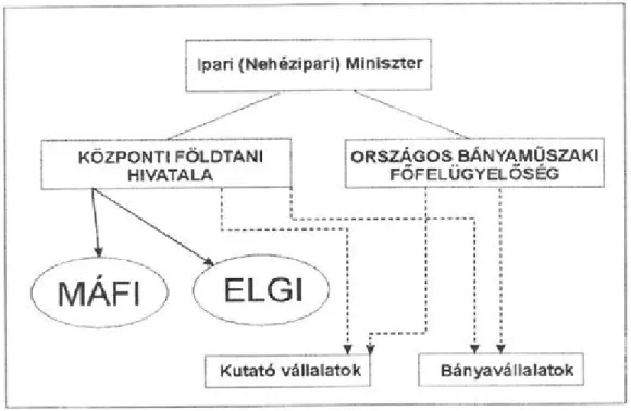
Figure 9.1 presents the state geological institutional system’s construction before 1994. The main authority of the geological research organization and financing was the Central Geological Office (later only KFH). KFH directed the two independent institutions of geological research directly: the Geological Institution of Hungary (later only MÁFI), carrying out geological research, and the Eötvös Lorand Geophysical Institute of Hungary (later MÁELGI or only ELGI), doing geophysical research. The KFH indirectly financed and supervised the other exploration and mining companies (for example Geological Research and Drilling Company – FKFV; Oil Research Company – KV) in their geological research, too. The state’s mining main authority, that is, the National Mine Technical Inspector, provided supervision over mining activities.
Figure 9.1 The state geological institutional system’s construction before 1994 [i]
(English translation of text in figure:
Ipari (Nehézipari) Miniszter - Minister of Industry (Heavy industry), Központi Földtani Hivatal - Central Geological Office,
Országos Bányaműszaki Főfelügyelőség - Main Technical Board of National Mining, MÁFI (Magyar Állami Földtani Intézet) - Geological Institute of Hungary,
ELGI (Eötvös Larand Geofizikai Intézet) - Eötvös Lorand Geophyiscal Institute of Hungary,
Kutató vállalatok - exploration companies, Bányavállalatok - mining companies.)
The state’s research and financing for mining and geological projects were decreased in the situation of the market economy because of the privatization after the political transformation in 1989-1990. The state spent money only on public interest geological research without a market profit in the new economy structure, while the privatized and new undertakings financed raw material research and mining production for profit. The significantly decreased tasks of the state were the reasons for the regulation created by Act 1993 - XLVIII on Mining. Figure 9.2 shows the state’s geological institution system that came into existence after the passing of the law. The Hungarian Geological Survey (MGSZ) was formed as the state’s special authority to attend to the state’s geological research tasks, with contraction of three previously independent institutes (KFH, MÁFI, and ELGI). This contraction, which amounted to more than 90%
of the employees being laid off, abolished MÁFI and ELGI’s monetary independence (only MGSZ’ cost line was in the Hungarian national budget), however both MÁFI and ELGI famed institutes were free in professional matters. Figure 9.3 shows the structure of the Hungarian Geological Survey.
Figure 9.2 The state geological institutional system’s construction after 1994 [ii ] (English translation of text in figure:
Gazdasági miniszter - Minister of Economy,
Magyar Geológiai Szolgálat - Hungarian Geological Survey, Magyar Bányászati Hivatal - Mining Bureau of Hungary, Gazdálkodó szervezetek - Economic Organizations, Önkormányzatok - Local Governments,
Hatóságok - Authorities.)
Figure 9.3 The organizational structure of the Hungarian Geological Survey [iii]
(English translation of text in figure:
Magyar Geológiai Szolgálat - Hungarian Geological Survey, Főigazgató - General Director,
Szakhatósági Főosztály - Authority Major Department, Információs Központ - Information Center,
Gazdasági Hivatal - Economy Office, Titkárság - secretary’s office,
Humánpolitika - human resources management, Belső ellenőr - controller,
Jogász - lawyer.
Szakhatósági Osztály - Authority Department,
Ásványvagyon Nyilvántartási Osztály - Mineral Resources Register Department, Területi Hivatalok - Regional Offices,
Országos Földtani és Geofizikai Adattár - National Geological and Geophysical Data Storage Department, Építési és Geotechnikai Adattár - Building and Geotechnical Data Storage Department,
Számítástechnikai Osztály - Department for Information Technology.)
In the MGSZ’s central part were the Economy Office and two organizational units: the Information Center and the Authority Department of the Hungarian Geological Survey. The Authority Department covered the MGSZ’s official scopes of authority (municipal, authorial and technical expertise). The Earth inside, its natural resources and all geoinformation about these were state owned, according to the regulations of the law on mining. So the Mining Bureau of Hungary (MBH), as domain mining authority of the state, licensed the mining permits (for example, permits for mine parcel formation or expansion). These permits had authority scopes and were available from the district mines inspectorate (the regional authorities: the District Mines Inspectorates of Budapest, Veszprém, Pécs, Miskolc, and Szolnok). It was possible to resort to the office’s second degree – to the MBH in Budapest – for legal redress against a first-degree decision. It was possible to attack the decisions published by MBH at the second degree in a civil court only in the case of a procedural law deficiency. The last sketched official scope is the strictest official jurisdiction with the opportunity of the final decision.
The Hungarian Geological Survey had the scope of authority in some cases only (for example the establishment of nuclear institutions, dumps of low and intermediate radioactive waste and high-level nuclear waste). It was necessary to get MGSZ’s geological authority support in all cases to the mining magisterial decisions by MBH. The MGSZ had got so-called "special authority scopes". So the special authority scope also is a very strict scope because the state office with official scope may not decide in opposition to the opinion of the office that has special authority scope. The expert opinion scope is the softest scope, because of theoretically the office bringing the final decision may decide contrary to the opinion of the organization publishing the expert opinion, but such a decision may bring harmful legal consequences for the office making the decision if later the practice justifies the correctness of the expert opinion.
MGSZ had expert opinion scope in several issues, and inside the framework of this other state offices (for example water management offices, environment protection offices, building authorities) asked for MGSZ’s opinion before the making of their magisterial decisions. The activities attached to the Authority Department’ scopes also had first and second degree competence. It was necessary to ask the permission for the geological research at MGSZ’s regional offices (first degree). The regional organizations of Hungarian Geological Survey are presented in Figure 9.4.
After reorganisation, seven regional organizations came into existence after 1994 (in Budapest, Sopron, Veszprém, Pécs, Salgótarján, Debrecen, and Szeged). The MGSZ decided to locate its second degree office, where appeal of the decisions of these regional offices was possible, in Budapest.
Figure 9.4 The regional offices of the Hungarian Geological Survey [iv]
The Information Center of the Hungarian Geological Survey was responsible for the state’s geological data management and supplying of data. There are two types of geological data, these are the public utility (open) data and the closed-usage (closed) data. Anyone may obtain the open data as a civic right, free of charge. (The data is free, but not the expenses of the service.) These geological research data came into existence with state financing before 1993. The closed data are geological and mining data that came into existence for authorized geological research and mining activities. It was necessary to surrender these data as research reports into the MGSZ’s data set each year, by December 31, but these data may not be made available to a third legal entity (another company) as long as the research or production right attached to this exists (closed treatment).
The state designated concessional research areas for the research of certain mineral raw materials after 1993, so concessional hydrocarbon research came into existence in Hungary in the second half of the ’90s. The MGSZ compiled geological informational packets relevant to the announced areas – the areas in which concessions were available for purchase – and then the research applications were submitted. The winning applicant obtained a concessional research right for an area after the evaluation of the applications. It was necessary to submit the research reports to the MGSZ each year about the geological information from the results of the concessional research.
The Hungarian government transformed the state geological institutional system again on 1 January 2007. The Hungarian Office for Mining and Geology (MBFH), as one single supreme mining and geological authority, came into existence with the merging of the Mining Bureau of Hungary + Hungarian Geological Survey + the Center for Structure- Reorganization of Coal Mining (see Figure 9.5).
Figure 9.5 The organizational structure of the Hungarian Office for Mining and Geology [v ] (English translation of text in figure:
Földtani és Adattári Főosztály - Geological and Databank Major Department,
Bányászati, Gázipari és Építésügyi Főosztály - Gas Industrial, Mining and Building Affairs Major Department, Jogi és Igazgatási Főosztály - Legal and Administrative Major Department,
Gazdasági Főosztály - Major Department of Economics, Elnök - President,
Elnöki főtanácsadó - General Adviser of President, Elnökhelyettes - Deputy Chairman,
Állami Kötelezettségek Programiroda - Office for State Obligations Management, Kommunikáció - Public Relations,
Tudományos- és intézményi kapcsolati vezető - manager for connection with scientific affairs and institutes, Belső ellenőrzés - Department for Controlling,
Jogi Osztály - Legal Department,
Humánpolitikai és Igazgatási Osztály - Division for Human Resources and Management, Informatikai és Adatvédelmi Osztály - Department for Informatics and Data Protection, Földtani Hatósági Osztály - Authority Department for Geology,
Ásványvagyongazdálkodási és Nyilvántartási Osztály - Department for Mineral Resources Management and Recording, Adattári és Információs Osztály - Data Storage and Informational Department,
Bányászati és Robbantás felügyeleti Osztály - Mining and Explosion Supervisional Department, Gázipari és Építésügyi Osztály - Gas Industrial and Building Affairs Department,
Járadék -bevételi Osztály - Mining Allowance Income Department,
Munkavédelmi Információs Szolgálat - Information Service for Labour Protection, Pénzügyi és Bérgazdálkodási Osztály - Financial and Wages Management Department, Számviteli Osztály - Counting Department,
Vagyon gazdálkodási és Üzemeltetési Osztály - Department for Resources Management and Operation, Bányakapitányságok - District Inspectorate of Mines.)
The Geological and Databank Department arranges the geological tasks of the special authorities, and the Gas Industrial, Mining and Building Affairs Department performs the mining authority tasks in this new form. The old district mines inspectorates of MBH became the new regional offices, with centers in Budapest, Veszprém, Pécs, Miskolc and Szolnok. MÁFI regained its full independence but ELGI was returned to MBFH’s construction after some months of self-reliance. (To be noted is that MÁFI almost got into a bankruptcy situation in 2010.) Four among the old MGSZ’s regional offices (Sopron, Salgótarján, Debrecen and Szeged) temporarily work longer as regional branch offices. You may read more detail in subsection 10.1 about the MBFH’s function, the competent areas of the regional offices and concessional regulation.
3. T
HE EXPLORATIONPHASES OFMINERAL RESOURCESThe exploration of mineral resources is an economic activity pursued in the interest of becoming aware of the mineral stocks of raw material of a given area. The aim of the exploration is a product of geological information (geoinformatics) that makes the solution of the mineral resources exploration task possible. In exploration, optimization has two focuses, from the viewpoints of the minimization of the expense and the maximizing of the profit.
Achievement of extra profit (higher profit than the average) is helped in the exploration phases recommended and accepted by the supreme geological authority (MBFH – Magyar Bányászati és Földtani Hivatal; Hungarian Mining and Geological Office).
For the accomplishment of mineral resources exploration two principles have to apply: the principles of full cognition and gradual cognition. The principle of full cognition of the geological property and the minable (industrial) property means the most accurate estimation possible at a given technological level. The prognosticatory geological property (prognosticatory property) is the quantity of a given mineral resource evaluated with devices of geological exploration and statistical methods in a country's area. The investigated geological property (geological property) is a given quantity of this manifested in the geological exploration for raw material, which is generally smaller than the prognosticatory property. The minable property (industrial property) is a quantity of a given raw material in a given period which can be produced economically in the given country. The industrial property changes dynamically as a function of the production expenses and the prices of raw material.
The principle of gradual cognition means the exploration phases being built atop each other. All higher exploration phases are based on the knowledge obtained in the previous phase, and require more detailed and more accurate exploration methods. The higher (later) exploration phases are generally costlier and more time-consuming.
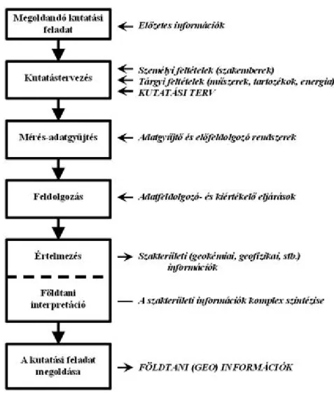
Figure 9.6 shows the linear exploration model which can be applied universally to geological-geophysical explorations.
It is necessary to plan the exploration based on the preliminary information collected before the start of the explorations. Planning the exploration means the formation of an execution plan, which is based on the planning of objective and personnel conditions. For each phase of the exploration plan it is necessary to draw up expense plans in parallel. We turn the specific information from the processing of the measured data during exploration into geological information with a geological interpretation (with the complex synthesis of the specialized information).
Figure 9.6 The linear model of exploration of mineral resources (English translation of the main text in figure:
Megoldandó kutatási feladat - Exploration task to be solved, Kutatás tervezés - Exploration planning,
Mérés-adatgyűjtés - Measuring and data acquisition, Feldolgozás - Processing,
Értelmezés - Interpretation,
Földtani interpretáció - Geological Interpretation,
A kutatási feladat megoldása - Solution of exploration task, Előzetes információk - preliminary information,
Személyi feltételek (szakemberek) - Personnel conditions (specialists),
Tárgyi feltételek (műszer, tartozék, energia) - Material conditions (instrument, accessory, power),
Kutatási terv - plan of exploration,
Adatgyűjtő és előfeldolgozó rendszerek - systems for data acquisition and preprocessing, Adatfeldolgozó és kiértékelő eljárások - procedures for data processing and evaluating,
Szakterületi (geokémiai, geofizikai, stb.) információk - special field (geochemistry, geophysical, etc.) information,
A szakterületi információk komplex szintézise - complex synthesis of special field information, Földtani (geo) információk - geological (geo) information.)
The exploration of mineral resources can be divided into the five phases of exploration:
basic and pre-exploration phase, exploratory phase,
preliminary exploration phase, detailed exploration phase,
post- or production exploration phase.
It should be noted that recently the office has accepted exploration plans with three phases. The first three phases are combined into a pre-exploration phase, a detailed exploration phase and an exploration phase under production.
The first phase can have two names, basic explorational phase or pre-explorational phase, depending on its financing.
When the geological and geophysical exploration of this phase is financed by the state, we call it the geological basic exploration phase; it is called a geological pre-exploration phase when the geological and geophysical exploration methods are financed by an enterprise.
The aim of the geological basic exploration phase is the exploration of general natural laws and regularities, new geological structures (constructions), the spatial and temporal processes and knowledge of their causal connections.
The aim of the geological pre-explorational phase is to carry out geological forecasts of the exploitable mineral raw materials. In the final exploration report of the phase, as the output of the exploration phase, the probability of the presence of the mineral raw materials has to be given, along with the genetics of the formation of the mineral raw materials, the expected settlement form of the raw materials, and the quantity of the prognosticated geological property. In this exploration phase the relatively cheap geological and geophysical exploration methods are applicable.
These are the small-scale (overview) geological and geophysical mappings. From among the more expensive exploration methods, at most some (2-3 pieces) exploratory wells may be authorized.
The aim of the exploratory phase is more widespread spatial marking to recognize the desired geological object (the depth province and the yielding of its horizontal expansion), and the designation of the hopeful area for further exploration. The designation of the hopeful area of further exploration means the gradual narrowing down of the exploration area generally. However, there is an opportunity for extension of the exploration area in justified cases. It is necessary to provide a detailed quantitative and approximate qualitative estimate of the explored mineral resource in the final report of this exploration phase. The detailed geological mapping and detailed geophysical surveys are the main methods of the exploratory phase.
The aim of the preliminary exploration phase is the spatial marking of the exploitable (suitable for industrial exploitation) area (deposit). The output of this exploration phase is the determination of the area for intervention (either exploitation or exemption from contamination). The main methods of the preliminary exploration phase are drilling research installed in the rare network, concerning mining explorations, complemented with large-scale geological mapping and geophysical measurements. (A rare network is a network in which any distance between two boreholes is farther than 1,000 meters.)
The aim of the detailed exploration phase is to determine the exploitable area, based on which it is possible to prepare the technical plan of the intervention (exploit, exemption). The output of this exploration phase is the development of the mine exploitation plan (the technical plan of mining), that must be submitted as part of the request for a mine opening permit from the Hungarian Mining and Geological Office. It is necessary to prepare a technical plan of the contamination exemption as the result of this exploration phase, in the case of geological explorations taking aim at the exemption of environmental contamination. The main methods of the detailed exploration phase are establishments (drilling, mining exploration) installed on profile or in the thick network, laboratory and in situ (ground) material tests, and industrial technological tests. (A thick network is a network in which the smallest distance between two boreholes is less than 100 meters.)
The aim of the exploration phase under production is the promotion of execution of intervention (exploit, exemption) plan, the preparation of the next production cycle. The completion of the production schedules and the exemption schedules means the output of this exploration phase to the next production or exemption phases. The main methods of the production exploration phase are a geophysical survey of the drilling and mine galleries under production and
geological, geotechnical mapping.
4. T
HEG
EOLOGICAL ANDG
EOPHYSICALD
ATABASE OF THEH
UNGARIANM
INING ANDG
EOLOGICALO
FFICEIt is amongst the many tasks of the Hungarian Mining and Geological Office (Magyar Bányászati és Földtani Hivatal – MBFH) to collect and preserve results from geological, geophysical and mining investigations and also to provide a properly regulated and up-to-date data service. The basis of these regulations can be found in the XLVIIIth Law of mining of 1993. This law obligates the mining contractor to annually supply the geological data he has gained during his activity to the state public service company (at that time it was the Hungarian Geological Service (Magyar Geológiai Szolgálat – MGSZ), today – in 2010 – it is the MBFH). Any provided data that are not business secrets are freely available from the Office. Although you have to pay for the data service, it has to be noted that it is not actually the data you are paying for; the service is subject to fees and its dues are determined by law. Continuous development of the used data-processing methods and devices is needed in order to fulfil the tasks of service and storage. Data that is organized in well-treated, modern ranged files or databases can serve as useful source material for both today’s and tomorrow’s generations.
Taking into account the specialities of the document- and data-files, the most important digitally based databases have been established at MBFH. The aim of this section is the presentation of the above-mentioned GIS and text-based databases, familiarization with data storage and the clarification of those mining and geological legislative basic concepts that are essential for this topic. In addition, the chapter perfectly illustrates one realization of GIS in everyday practice.
It was the Information Technology Department of the MGSZ, cooperating with the Hungarian Geological and Geophysical Database and the Eötvös Lorand Geophysical Institute (ELGI) that established the Geological Information System in the 1990s. It includes the registration databases and exploration meta-databases that are GIS databases describing the features of specific data. The exploration meta-databases were completed firstly under the Microstation system; today they are available in the format of shapefiles of ESRI ArcView. The maps contain vector-type data, according to the specialities of the measurement in the forms of dots, lines or area.
Data
Data – according to the type of the data medium – can be classified into three large groups. One of the two older groups is the paper-based stock, the core of which is made up by the data of the MÁFI (Magyar Állami Földtani Intézet - Hungarian Geological Institute) Geological Basic Database, formed in 1952, and its successors. From its formation in 1994 the size of the stock of the Hungarian Geological and Geophysical Database belonging to the Information Centre grew fourfold in only eight years. Most of the materials are registered but one part – mostly probate (or legacy) and data of neighbouring scientific fields – only has a summary list. The reports, drilling documentations, maps, paus drawings and microfilms also belong to the paper-based group. The other older group contains the samples of drilled cores, rocks, etc.
The third and most recent group is the group of computer databases. At first these were only registration databases, and real GIS databases began to form and to be brought up-to-date only in the beginning of the 1990s.
Registration databases were established in the following major topics:
Registry of reports: A traditional bibliographic database of the files managed by the MGSZ and by companies in connection with it. It has a simple structure, based on Microsoft FoxPro. Its metasearcher is freely available on-line at the homepage of the MBFH; it has a simple search interface (Fig. 9.7) and you can filter the data according to the author, title, year and site. With the help of the gained data you can get to know in which database you can find the information you are searching for.
Fig. 9.7 Search window for database of report storehouse [vi]
Basic Registry of Well Drilling: This contains information about approximately 182,000 drillings. You can find here the most important features found in the drilling documentation – according to which the drilling can be identified.
Basic Data of Well Drilling: This contains data of approximately 60,000 drillings that correspond with the above- mentioned Basic Registry of Drillings. It contains drillings deepened within the confines of the Hungarian Basic Section Programme, or those that were subsequently classified as basic drillings. Compared to the Basic Registry of Drillings, in this database aging and macroscopic rock description can be found.
Water Prospecting Drilling: This belongs to the Basic Registry but for practical purposes it is managed separately. It contains approximately 75,000 drillings. I would remark here that there are data in each database connected to drillings that cannot be found in other databases.
Hydrocarbon Prospecting Drilling: Understandably, this is also managed separately, although many drillings of this group were re-qualified as thermal water prospecting drillings.
Well Drilling Data Managed by Companies: This is an itemized registry of state-owned data that remained at geological-mining companies. It is a fairly well- composed database, but its data content and inner structure are not uniform.
The first concept of creating a national database of geological GIS data was proposed by Farkas István in 1991. Its essence is that because of the huge quantity of data you have to create a two-level system consisting of metadatabases and thematic databases. If we imagine the databases as a pyramid, then on the top of it you can find the metadatabases in regional scale, and below this there are the thematic databases sorted according to the methods of investigation. The thematic databases have to be attached to the central databases and also to each other. Besides this, the databases of ELGI and MÁFI also have to be attached. In this case the metadatabases are exploration databases (Fig. 9.8), this way they can be interpreted as GIS databases that contain information about one specific measurement (place, date, method, availability, etc.) and these are described on the appropriate maps by objects (dots, lines, area) appropriate to the nature of the measurement. With their help the exploration of the data of MAFI and ELGI measurements becomes much easier.
Firstly meta-databases of geoelectric, magnetic, torsion balance data, gravitational, well-log and seismic measurements were made in ELGI. But these are only useful in practice – similar to every database – if they are up to date. Input of the available data was finished only in 1998. In contrast with this, the thematic databases found in lower levels contain more specific data. Here you can find actual geological and geophysical information for a specific region.
In the case of these databases it is the subject that determines their structure. Besides the specific measured data, you can find databases of libraries and data stores of which no GIS version exists. Within the ELGI databases, due to modern measurement techniques, most of the field data are generated in digital form, which made computer processing easier. Nowadays the need for access via the Internet has appeared. As the data gained from the research of private companies can be considered as business secrets, a system of rules had to be worked out. This can be realized through authority levels. However, it is not necessary to use such a supervisory method for meta-databases, of course. These meta-databases are also available via the internet nowadays, on the webpage of the MBFH .
Fig. 9.8 Hydrogeological exploration metadatabase [vii ]
The Public Internet Geophysical Data Service (KINGA ) operates under the control of ELGI; this service can be used freely, it only needs registration. Unlike the databases demonstrated earlier, here we can access real measured data.
The aim of this portal is using public geophysical data mass in an easier way than before. The targeted fields are environmental protection and environmental industry (including work oriented for locating radioactive wastes), waterbase protection, prospecting, usage of thermal water, installation of geothermal power plants, disaster recovery and preparation of major works. For scientific research (general geological research, magnetosphere exploration, lithosphere investigation, CO2 location, etc.) the data systems are familiar, here the increase of effectiveness is expected from the ease of access. The digital geophysical map library (Fig. 9.9) is available here, which allows you to browse maps of many parameters in 1:100000 scale and to access EOV map pages that can be downloaded in raster format (jpg) for further application. Furthermore, there is a module for creating maps of geophysical surveys (Fig.
9.10). With its usage after setting the desired site, you can get a catalogue of the stored geophysical data, or there is an opportunity to make a text search amongst the metadata. Both systems work under GIS, of course. Detailed information is available through the https://kinga.elgi.hu/ link.
Fig. 9.9 Digital Geophysical Map Library [viii]
Fig. 9.10 Geophysical Survey Map Search [ix]
DIGITAL IMAGE PROCESSING
The Basic Concepts of the Registry and Management of Mineral Resources
The above-mentioned XLVIIIth Law of mining of 1993 clearly determines the basic concepts related to the registry of mineral resources and the mining and management of mineral resources. It is important to know that wealth found below the surface belongs to the state anywhere in the world, with the exception of a few countries (e.g. the USA, where the wealth belongs to the landowner).
"Mineral resource" refers to any kind of mineral that can be utilized in the actual scientific-engineering level of development. Soil and water – independent of their consistency – are not considered mineral resources; they are covered by special legislation.
"Mineral wealth" is a part of the mineral resources whose quantity and quality is determined by estimation or calculation on the basis of geological, mine engineering and mine management aspects.
"Management of mineral wealth" means the activities, arrangements, production programmes, systems and methods of research, exploration and cultivation that serve the economical exploitation of mineral resources by preserving those parts of the occurrence that are not cultivated in order to save their exploitability for a later occasion. At the same time these activities enable the reduction of losses and a more complete exploitation of the mineral wealth in a technically possible way that is also justified by market conditions.
"Mining (mining activity)" includes research, exploration and exploitation of mineral resources, treatment of these activities’ wastes and management of mineral resources. (Here belong the preparation of resources, sorting, stocking, closing mines, geothermal research, exploitation and hydrocarbon mining.)
"Preliminary research" is a research activity for the detection of the occurrence of a mineral resource and also for the determination of the approximate extent and quantity of the mineral resource.
"Exploration" is a mining activity for commencing the exploitation of the mineral resource.
"Geological exploration" is a scientific-engineering activity for the recognition of the material, structural and evolutional features of the Earth’s crust; except for those activities that tend to investigate protected areas or areas worth protection.
"Geological wealth" is the total amount of mineral wealth proved by research that can be determined by calculations knowing the quality and quantity parameters (so-called recording conditions) of the specific resource, without taking into account the economical and engineering conditions and limits of the future exploitation. The amount that can be actually brought to the surface from the total geological wealth of a prospect does not only depend on the geological features (the quantity and quality of the wealth, type and depth of the reservoir, thickness, water hazard, etc.) but also on the technological-engineering possibilities of the mining activity. In the case of fluids (crude oil, natural gas
and carbon-dioxide gas) the exploitable wealth is the geological wealth multiplied by the exploitation factor.
"Industrial wealth" is the part of the geological wealth that is economically exploitable at a specific time.
"Research region" describes the area defined in the concession contract or an order denoting exploration rights for researching mineral resources or geothermal energy.
"Occurrence" is the natural location of a mineral resource (e.g. a layer, reservoir or deposit).
"Geological data obliged to be supplied" refers to the geological data that a mining contractor obtains directly from the research and exploitation of mineral resources or indirectly from processing the geological basic data.
"Material benefit" is a kind of mineral resource where the determination of the mining site is primarily tended to, and that represents those values that makes its exploitation justified under specific geological, engineering and economic circumstances.
"Exploitable mineral wealth" is used to name that part of the geological mineral wealth in the mining site that can be exploited in the specific scientific-technical level of development, decreased by the wealth fixed in pillars (marginal and defending pillars).
The mineral resources and the geothermal energy are state property in their natural place of occurrence. The exploited mineral resources are converted to the property of the mining contractor by exploitation and the geothermal energy extracted for energy purposes by its utilization. The mining contractor is obliged to pay royalties for these to the state. The process in which the state gives the right of exploitation to the mining contractor is called concession. Its purpose is the encouragement of more effective state operation.
After the clarification of these basic concepts you can understand the data range that has to be delivered, and also be able to understand the operations of the systems presented in the following sections.
The mineral wealth of Hungary
Registry is a complex process (and a diverse one, according to the types of resources), during which the change of mineral wealth is being calculated annually for every single registration unit (block), then for the specific place of occurrence and finally for different summarization levels in categories of recognition. The movement between the categories of recognition and stock redistribution is also traceable this way.
Table 9.1 Summarized data of the known mineral wealth of Hungary [x ]
You also have to understand that together with the exploitation the geological wealth of any kind of mineral can grow if recent research yields results (Table. 9.1).
THE MINERAL WEALTH OF HUNGARY
The known mineral wealth of Hungary is presented in Fig. 9.11. From the figure it can be seen that the quantity of hydrocarbons is small, while non-metallic mineral raw materials make up the largest part. However, considering their market value, the hydrocarbons carry the largest value.
Fig. 9.11 The known mineral wealth of Hungary (2008) [xi]
Examining the hydrocarbon property in detail (Fig. 9.12) we can see natural gas is the largest and crude oil the smallest in proportion. Also indicated in Fig. 9.12 is the estimated number of years of mining production of the present supply possible, at the 2008 production level. This indicates that Hungary's crude oil supplies could be exploited for 22 years more, its natural gas supply for 23 years, and its CO2 supply for more than 100 years. (All estimates for years of exploitation possible in Figs. 9.11 to 9.15 are based on 2008 production quantities.)
Fig. 9.12 Explored hydrocarbon property of Hungary (2008) [xii ]
The coal property is visible in Fig. 9.13. Lignite is available in the largest quantity. while the quantity of black coal and brown coal each provide around 25% of the coal supply. For all three types of coal the supply is sufficient for more than 100 years. (It should be noted that the production of brown coal was insignificant and no black coal was produced in our country in 2008.)
Fig. 9.13 Explored coal resources of Hungary (2008) [xiii]
Figure 9.14 shows the ore property. Among these ores only bauxite and manganese were being produced in 2008.
Both of these ores are sufficient for more than 100 years.
The non-metallic mineral raw materials property (mineral mining raw materials, cement and lime industry raw
materials, construction industry raw materials, sand, gravel, ceramics industry raw materials, peat) are shown in Fig.
9.15. Sand and gravel are present in the largest amount and peat in the smallest proportion. A sufficient supply of all mineral raw material ones for more than 100 years of mining production is at the country's disposal.
In summary, from the numbers given in Figs. 9.11-9.15 Hungary can be classified as having an average supply of mineral raw materials.
Fig. 9.14 Explored ore property of Hungary (2008) [xiv]
Fig. 9.15 Non-metallic mineral raw materials property of Hungary (2008) [xv ]
5. Q
UESTIONSFOR REVISIONFeladat-hozzáférés beállítása
BIBLIOGRAPHY:
[i] From I. Farkas 2002
[ii] From: I. Farkas 2002
[iii] From: I. Farkas 2002
[iv] From: I. Farkas 2002
[v] From I. Farkas 2010
[vi] Source: http://www.foldtanikutatas.hu/mbfh/]
[vii] Source: http://www.foldtanikutatas.hu/MegKutApp/
[viii]Source: http://kinga.elgi.hu/
[ix] Source: http://kinga.elgi.hu/
[x] Source: http://www.mbfh.hu/home/html/index.asp? msid=1&sid=0&hkl=72&lng=1
[xi] Source: Farkas I. 2010
[xii] Source: Farkas I. 2010
[xiii]Source: Farkas I. 2010
[xiv]Source: Farkas I. 2010
[xv] Source: Farkas I. 2010
Digitális Egyetem, Copyright © Turai Endre, 2011
![Figure 9.2 The state geological institutional system’s construction after 1994 [ii ] (English translation of text in figure:](https://thumb-eu.123doks.com/thumbv2/9dokorg/1128036.79809/3.892.176.718.364.722/figure-state-geological-institutional-construction-english-translation-figure.webp)
![Figure 9.3 The organizational structure of the Hungarian Geological Survey [iii]](https://thumb-eu.123doks.com/thumbv2/9dokorg/1128036.79809/4.892.156.741.71.532/figure-organizational-structure-hungarian-geological-survey-iii.webp)
![Figure 9.4 The regional offices of the Hungarian Geological Survey [iv]](https://thumb-eu.123doks.com/thumbv2/9dokorg/1128036.79809/5.892.163.754.256.653/figure-regional-offices-hungarian-geological-survey-iv.webp)
![Figure 9.5 The organizational structure of the Hungarian Office for Mining and Geology [v ] (English translation of text in figure:](https://thumb-eu.123doks.com/thumbv2/9dokorg/1128036.79809/6.892.140.770.64.415/figure-organizational-structure-hungarian-office-geology-english-translation.webp)
![Fig. 9.7 Search window for database of report storehouse [vi]](https://thumb-eu.123doks.com/thumbv2/9dokorg/1128036.79809/10.892.191.719.76.374/fig-search-window-database-report-storehouse-vi.webp)
![Fig. 9.8 Hydrogeological exploration metadatabase [vii ]](https://thumb-eu.123doks.com/thumbv2/9dokorg/1128036.79809/11.892.110.792.69.423/fig-hydrogeological-exploration-metadatabase-vii.webp)
![Fig. 9.9 Digital Geophysical Map Library [viii]](https://thumb-eu.123doks.com/thumbv2/9dokorg/1128036.79809/12.892.120.792.66.518/fig-digital-geophysical-map-library-viii.webp)
![Table 9.1 Summarized data of the known mineral wealth of Hungary [x ]](https://thumb-eu.123doks.com/thumbv2/9dokorg/1128036.79809/14.892.148.763.638.1050/table-summarized-data-known-mineral-wealth-hungary-x.webp)
