LOESS inFORM
4
In memóriám
MÁRTON
PÉCSI
REGIONAL STUDIES ON LOESS
LOESS inFORM 4
Recommended by the Commission on Loess of the International Union of Quaternary Research
Geographical Research Institute Hungarian Academy of Sciences
Chief editor: MÁRTON PÉCSI
Editorial board L. BASSA Z. KERESZTESI É. KIS
F. SCHWEITZER
REGIONAL STUDIES ON LOESS
Edited by ÉVA KIS
In memóriám Márton Pécsi (1923-2003)
Budapest 2004
Geographical Research Institute Hungarian Academy of Sciences
Associate editor L. BASSA
Cover design A. KOVÁCS
Front cover: M. Pécsi delivering explanation in the Paks brickyard (upper photo) and the Mende exposure (lower photo)
Back cover: The Paks brickyard exposure
Desktop editor E. GARAI-ÉDLER
Technical board M. MOLNÁR, I. POOR
HU ISSN 0238-065X ISBN 963 9545 03 1
Copyright © 2004 Geographical Research Institute Hungarian Academy of Sciences
All rights reserved. No part of this volume may be reproduced by any means, trans
mitted or translated into machine language without the written permission of the pub
lisher.
Published by the Geographical Research Institute HAS Responsible publisher: Fe r e n c Sc h w e i t z e r, director Printed in Hungary by EXEON Bt.
Contents
Loess and Quaternary: The geomorphologist’s approach... 7 Pécsi’s publications on loess: A selected bibliography...9
Bolikhovskaya, N.S.: Paleoenvironments and climatostratigraphy
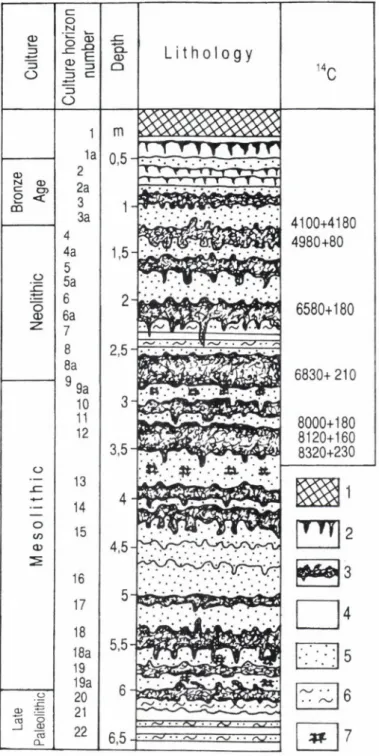
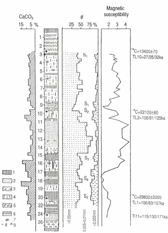
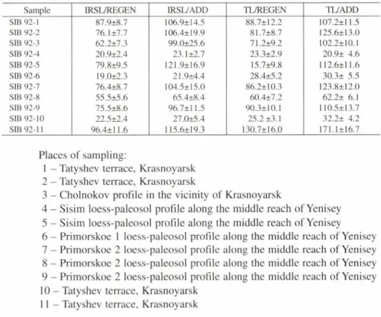
of the loess-paleosol formation of Northern E u ra sia ...11 Pécsi, M.-Schweitzer, F.-Yamskikh, A.F.-Frechen, M.: Comparative
studies of terraces and loess sections in the vicinity of Krasnoyarsk
in the Yenisey v a lle y ... 37 Liu, Tungsheng-Guo, Zhengtang: Variations of eolian iron over the last
900 ka as recorded in the Xifeng loess section in China and the im plications.... 55 Frechen, M .-Pécsi, M .: Abony brickyard: IRSL and TL analysis of
“infusion loess” ... 63 Sümegi, P.-Krolopp, E.: The Ságvár-Lascaux interstadial (Upper Weichselian)
and its palaeoecological reconstruction... 71 Gams, /.: Recent and Pleistocene chemical erosion in the Alpine and Dinaric karst
(A case study from S lov en ia)... 81 Starkei, L.: Terrace formation versus slope evolution in the incised Carpathian
valleys during the Quaternary... 95 Moments of a life ...101
Loess and Quaternary: The geomorphologist’s approach
Márton Pécsi received a traditional training of a physical geographer at the Uni
versity of Budapest. Though he was a scholar of versatile interest, his scientific career primarily concerned history of landform evolution, and he viewed the Earth surface as a sharp-eyed geomorphologist. Searching for an explanation of the phenomenon that many loess varieties exist, Pécsi emphasized that loess is not just the accumulation of falling dust. Types of loess and loess-like deposits might differ in basic parameters of grain size distribution, mineral composition and lithological properties. Loess properties are the result of physical, chemical, biological and pedological processes taking place under environmental conditions favourable for diagenesis (loessification), i.e. weathering of the parent material mainly in semi-arid grassland (steppe) or forest steppe.
Along his professional lifeline as a geomorphologist, Quaternary researcher and expert on loess Pécsi had the best opportunities to study the distribution of loess virtually all over the world. The fact that loess and loess-like deposits occur over a variety of landforms attracted him to different areas of the world where these sequenc
es are encountered in extensive plains, major river basins and valleys, on plateaus and pediments. His earliest investigations in the 1950’s included terrace formation in the Middle Danubian Basin, where he was challenged by the problem of rate of sedimen
tation. In the 1960’s during his stay in the USA, when he was awarded with Ford schol
arship he saw loesses in the Great Plains of the prairie belt and those in the Lower Mississippi Basin. Using another research grant in the USSR he visited a similar ex
tensive area of loess formation, the Middle and Southern Russian Plain. Later, already as an acknowledged authority Pécsi was a permanent participant of international field symposia and was made acquainted with the plain loesses of the Lower La Plata and Lower Huanghe. He visited the Chinese and Siberian loess plateaus and one of his last field trip in the late 1990’s led him to the Columbia Plateau. Loesses of Central Asia of different origin confined to pediments were the topic of a post-congress field excursion (Moscow INQUA, 1982) and the conspicuous non-typical loess varieties in New Zealand were figuring at an earlier congress (1973). In the same year he saw the ‘yedoma’ loess-ice complex during a field symposium in North Siberia. Natural
ly the valley loesses of Middle Rhine, Lower Seine and other deposits along Vistula, Oder, Elbe and Main were the occurrences he revisited during his long active period.
The origin of quartz grains of 10-50 micron size making up the bulk of loess material was a recurring theoretical problem of loess formation (frost action, glacier grind
ing, deposition of river load during floods, combination of glacial and desert i.e. cold and warm loess theories). The unique loess fabric is a textured loam, not merely simple sediment. By the end of his life Pécsi strongly concerned himself with the primary role of pedogenic-geochemical processes in the formation of the coarse silt fraction.
The loess-paleosol sequences undoubtedly provide the best opportunity for the reconstruction of Quaternary cyclical climatic and environmental changes and for its chronological subdivision. The basic principle is that loess strata represent cold
and dry climates (glacials), whereas paleosols indicate relatively warmer and wetter paleogeographic conditions (interglacials or interstadials). When studying loess pro
files Pécsi emphasised the decisive role of their geomorphological position along with bio- and lithostratigraphical composition and absolute chronological record. He paid a special attention to erosion gaps for sections in uplifted position and sediment traps in subsiding areas. In the basins the number of loess, sand and paleosol horizons could be twice as high as that of the similar units on plateaus or foothills.
Acknowledging that the loess sequence of the Loess Plateau in China exhibit a quasi-complete stratigraphic subdivision (with 24-37 loess horizons and an equal number of paleosols) down to the Quatemary-Neogene boundary 2.4 million years ago, Pécsi held that true loess has formed approximately since 1 million years ago.
The deeper, older series usually consist of pink silt subseries alternating with or un
derlying red paleosols formed in subtropical paleoecological environment.
Chronostratigraphical correlation in a global scale has been a challenge to loess experts in general and to Márton Pécsi in particular. He made considerable efforts to rec
oncile various Quaternary time scales that suggest or reflect cyclic climatic and environ
mental change (radiation changes by Milankovias, 0 18/16 ratio in deep-sea deposits, chang
es of magnetic susceptibility in sequences, fluctuations of C 0 2 pressure in polar ice, pollen spectrum changes etc.). At the same time he pointed to information on certain climatic types to be gained from the traces of frost phenomena in the zones of cold loess, buried dells and river terraces and professed that the time of past events can be established from the lithostratigraphic framework with some probability.
Regional correlation was another important field of Pécsi’s scientific activity. Key loess an Quaternary profiles in the Carpathian Basin: Paks, Mende, Basaharc, Gyöngyösvisonta and others have become familiar to the international community of loess experts who visited these sites frequently and took an active part in chronostratigraphic investigations, deploying novel methods of dating and laboratory analyses.
Making use of his rich experience in Quaternary geology Pécsi became a permanent contributor to mapping in the most various scales. He was a co-author of the Loess map of Europe (1977), compiled a loess map of Hungary (1982) and his map of loess of the Northern Hemisphere was included in a paleogeographic atlas of the late Pleistocene and Holocene (1992).
The past decades saw an amazingly rapid advancement of methodical ap
proaches in loess research. Technological development has made the traditional meth
ods (e.g. SEM analyses in biostratigraphy) more sophisticated, new methods of ab
solute dating (e.g. IRSL and TL analyses) came to the fore. Quantitative analyses and modelling gained impetus. These developments had prompted Pécsi to reconsider his chronological subdivision of the Quaternary. In the last decade of his active period he tended to assign older age to paleosols hitherto classified into the sequence of
“young loess” i.e. formed in late Pleistocene.
Pécsi’s activities as an organiser and manager in international science were far-reaching. He was president of the Commission on Loess of the International Qua
8
ternary Association (INQUA) between 1977 and 1991, worked in the Subcommis
sion on European Stratigraphy of IGU and acted as president of the Carpatho-Balkan Geomorphological Commission. He was one of the editors-in-chief of the Atlas of Paleoclimates and Paleoenvironments of the Northern Hemisphere (Late Pleistocene- Holocene) published in international co-operation (1992).
Pécsi’s publications on loess: A selected bibliography
PÉCSI, M. 1964. Ten years of physicogeographic research in Hungary. - Akad. Kiadó Bp. (Studies in geography in Hungary 1.) 132 p.
PÉCSI, M. 1965. Zur Frage der Typen der Lösse und lössartige Sedimente im Karpatenbecken und ihrer lithostratigraphischen Einteilung. A Kárpát-medencebeli löszök, lösszerű üledékek típusai és litosztratigráfiai beosztásuk. - Földr. Köziem. 13. (89.) pp. 305-323. (German), 324-356. (Hungarian)
PÉCSI, M. 1965. Genetic classification o f the deposits constituting the loess profiles of Hungary. - Acta Geologica 9. 1-2. pp. 65-85. Sum.: Russian. Geneticheskaja klassifikacija osadkov v obnazhenijakh plejstocenovykh lessov Vengrii.
PÉCSI, M. 1967. Classification génétique des loess dans le Bassin Carpathique. - Mélanges de géographie physique, humaine économique, appliquée offerts a M. OmerTulippe, 1. Géographie physique et géographie humaine. Gembloux, 1967. J. Duculot. a. A. pp. 164-187.
PÉCSI, M. 1968. Loess. - Encyclopedia of geomorphology. New York, Amsterdam, London. Reinhold Book Corp. pp. 674-678.
PÉCSI, M. 1972. Scientific and practical significance o f loess research. - Acta Geologica 16. 4. pp.
317-328.
PÉCSI, M. 1974. Loess. - Encyclopaedia Britannica. M acropaedia 11. Chicago, London etc., W Benton and H. Meningway Benton, pp. 24—28.
PÉCSI, M. 1976. Genetic classification o f the deposits constituting the loess profiles of Hungary. - Periglacial processes, Stroudsburg, Dowden, Hutchinson and Ross. pp. 337-387. (Bench
mark papers in geology 27.)
PÉCSI, M .-PÉCSI-DONÁTH É.-SZEBÉN Y I, E.-H A H N , GY.-SCHW EITZER. F.-PEVZNER, M .A. 1977. P aleogeographical reconstruction o f fossil soils in H ungarian loess. A magyarországi löszök fosszilis talajainak paleogeográfiai értékelése és tagolása. - Földr.
Köziem. 25. (101.) 1-3. pp. 94-128. (English), pp. 128-137. (Hungarian)
PÉCSI, M. 1978. Paläogeographische Forschung und Vergleich der ungarischen und europäischen Lösse. - Nagl, H. (Hrsg.) Beiträge zur Quartär- und Landschaftsforschung. Festschrift zum 60. Geburtstag von Julius Fink. Wien. Hirt. pp. 413—433.
PÉCSI, M .-MÁRTON, P.-SZEBÉNYI, E.-WAGNER. M. 1979. Alluvial loess (infusion loess) on the Great Hungarian Plain. Its lithological, pedological, stratigraphical and paleomagnetic analysis in the Hódmezővásárhely brickyard. - Acta Geologica 22. l^ L pp. 539-555. Stud
ies in Loess. INQUA Loess. Comm. Conference. Akad. Kiadó Bp., pp. 539-555.
PÉCSI, M. 1982.The most typical loess profiles in Hungary. - Pécsi, M. (ed.): Quaternary studies in Hungary. Budapest, INQUA Hungarian National Committee, Geogr. Research Inst. Hun
garian Acad, of Sciences, pp. 145-170. (Theory-m ethodology-practice 24.)
PÉCSI, M. 1984. Contemporary problems of loess research reflected by the activity of the INQUA Comm, on Loess. - Loess Letter 12. pp. 18-31.
PÉCSI, M. 1984. Is typical loess older than one million years? - Pécsi, M. (ed.): Lithology and stratigraphy of loess and paleosols. Geogr. Research Inst. Hung. Acad, of Sei. pp. 213-224.
(Theory-m ethodology-practice 30.)
PÉCSI, M. 1987. International Loess Symposium in China. Xian, Shaanxi Province. October 5-16.
1985. - GeoJoumal 14. pp. 435-445.
PÉCSI, M. 1987. The loess-paleosol and related subaerial sequence in Hungary. - GeoJournal 15.
2. pp. 151-162.
PÉCSI, M. 1990. Loess is not just the accumulation of dust. - Quaternary International 7-8. pp. 1-21.
PÉCSI, M. 1991. Distribution and chronological problems of loess. - GeoJoumal 24. 2. pp. 139-141.
PÉCSI. M. 1992. Loess o f the last glaciation. - Frenzel, В.-Pécsi, M.-Velichko. A. A. (eds.): Atlas o f paleoclimates and paleoenvironments of the Northern Hemisphere. Budapest-Stuttgart, Geogr. Res. Inst. Hung. Acad, of Sei., Gustav Fischer Verlag, pp. 110-119.
PÉCSI, M. 1993. Quaternary and loess research. Budapest. Geogr. Res. Inst. Hung. Acad, of Sei. 82 p.
(Loess inForm 2.) Summary and bibliography of Pécsi M.: Negyedkor és löszkutatás. Bp., Akad. Kiadó, 1993.
PÉCSI. M .-SCHW EITZER. F. 1993. Long-term terrestrial records of the Middle Danubian Basin.
- Quaternary International 17. pp. 5-14.
PÉCSI, M .-DERBYSHIRE, E.-SMALLEY, I. (eds.) 1994. Geotechnical aspects of loess. - Qua
ternary International 24. 52 p.
PÉCSI, M. 1995. Concept o f loess, a comprehensive information. - Pécsi, M .-Schweitzer, F. (ed.):
Concept of loess, loess-paleosol stratigraphy. Budapest, Geogr. Res. Inst. Hung. Acad, of Sei. (Loess inForm 3.) pp. 9-21.
PÉCSI, M. 1995. The role of principles and methods in loess-paleosol investigations. - GeoJournal 36. 2-3. pp. 117-131.
PÉCSI, M .-R IC H TER , G. 1995. Löss. H erkunft-G liederung-Landsehaften. Berlin, Stuttgart, G ebrüder Borntraeger. 1996. 391 p. (Zeitschrift für Geomorphologie. Supp.-Bd. 98.) GeoJournal 36. 1995. 2-3. pp. 197-198. (A book review)
PÉCSI, M.-HELLER, F.-SCHWEITZER, F.-BALOGH, J.-BALOGH, M.-HAVAS, J. 1995. A new loess-paleosol sequence of Paks in Hungary. - Pécsi, M.-Schweitzer, F. (eds.): Concept of loess, loess-paleosol stratigraphy. Budapest, Geogr. Res. Inst. Hung. Acad. Sei. pp. 63-78.
(Loess inForm 3)
PÉCSI, M .-RICHTER, G. 1996. Löss. H erkunft-G liederung-Landschaften gewidmet dem 14.
INQUA-Kongreß in Berlin. Stuttgart, Gebrüder Borntraeger. 391 p.
PÉCSI, M. 1997. Loess and other subaerial sequences in the Middle Danubian Basin. - Earth Sci
ence Frontiers, Beijing 4. 1-2. pp. 43-62.
NEMECZ, E.-PÉCSI, M.-HARTYÁNI, Zs.-HORVÁTH, T. 2000.The origin of the silt size quartz grains and minerals in loess. - Quaternary International 68-71. pp. 199-208.
PÉCSI, ^M.-NEMECZ, E.-HARTYÁNI, Zs.-HORVÁTH, T. 2000. Formation of minerals in loess and soils. - Acta Geologica Hungarica, Vol. 43/4. pp. 379^404.
10
Loess inForm 4. 2004. pp. 11-36.
Geographical Research Institute Hungarian Academy o f Sciences
Paleoenvironments and climatostratigraphy of the loess-paleosol formation of Northern Eurasia
Na t a l iy a S . Bo l i k h o v s k a y a1
A b stra c t
This paper is a summary of some chapters of the author’s book - N.S. Bolikhovskaya: The Evolution of Loess-Paleosol Formation of Northern Eurasia. Moscow. Moscow State University Pub
lishing House. 1995. 270 pp. Illustrated. (Reviewers: Prof. A.A.Velichko and Prof. V.N. Konischev), - which discusses problems of paleogeography, chronostratigraphy and genesis o f loess and fossil soils.
The results of a multi-member chronostratigraphic subdivision o f the loess-paleosol for
mation (LPF) of the Russian Plain are presented. A correlation of basic paleogeographical events of the loess areas in the Pleistocene are assessed. Landscape and climatic conditions of the epochs of the loess-paleosol formations in the East European, West European and Central Asian loess prov
inces are characterised. It was defined that the Matuyama-Brunhes paleomagnetic inversion is con
fined to the base of the Gremyach’e = Cromer II = Westerhoven interglacial sediments. Brunhes normal polarity epoch contains 8 interglacials: G remyach’e = Westerhoven, Semiluki = Rosmalen, Muchkap = Voigtstedt = Noordbergum, Likhvin s.str. = Holstein, Chekalin = Kamenka = Domnitz, C herepef = Romny, Mikulino = Eem, Holocene and dividing them 7 glacials: Devitsa = Glacial B, Don = Glacial C, Oka = Elster, Kaluga = Borisoglebsk, Zhizdra = Orchik, Dnieper = Saale, Valdai = Weichsel. For the first time detailed reconstructions o f phytocoenotic and climatic succes
sions of the main stages, i.e. 8 interglacials and 7 glacials (including 9 interstadials and 10 stadials during Valdai = Weichsel) of the loess-paleosol formation and another sediments of the Russian Plain, various glacial-periglacial and extraglacial regions have been identified.
Introduction
When considering results of more than 160 years of investigations into loesses and interbedded fossil soils, it should be admitted that many problems related to their origin, stratigraphy, and correlation are still debated, as are environmental and cli
matic conditions of loess formation. The most controversial items are the genesis of loess, as well as its specific property of collapsibility, age and correlation of paleosols and loess horizons, and paleoenvironments having existed during loess formation.
1 Department of Geography, Moscow State University 119899 Moscow, GSP-3, RUSSIA.
The principal method applied to these studies was the palynological approach.
It permits to characterise paleoenvironments of all the stages, including loess forma
tion, and not only those of soil formation. In this way, a whole sequence of changes in flora, vegetation, and climate can be traced within each stage of the evolution of the loess-paleosol formation (LPF).
The first attempts at palynological studies of loess and fossil soils of North
ern Eurasia were made in the 1930s by V.N. Sukachev, Z.K. Dolgaya (1937), and V.P.
Grichuk (1940). Later on, the studies were stopped and resumed only in the 1950s by E.T. Lomayeva. Since the 1960s a number of specialists have been engaged con
tinuously in research on the spore and pollen of LPF (V.P. Grichuk, B. Frenzel, S.I.
Parishkura-Turlo, A.T. Artyushenko, G.A. Pashkevich, N.S. Bolikhovskaya, Z.P.
Gubonina, R.E. Giterman, M.M. Pakhomov, E.E. Gurtovaya, L.G. Bezus’ko, B. Ur
ban, N.P. Gerasimenko, E.M. Malaeva, and many others). Detailed palynological stud
ies have been conducted on loess-paleosol series of different age, on the layer-by-layer basis, (see Bolikhovskaya 1975, 1981, 1982, 1984, and others; Pashkevich 1977;
Pakhomov 1983). The results including other published palynological data on LPF (summarised by the author) revealed a prevailing misconcept that loesses and loess
like deposits were formed under conditions of glacial climate exclusively, while fos
sil soils were products of interglacial and interstadial environments. To substantiate the conclusion, it was necessary to carry out a detailed paleobotanical analysis of the most representative sequences in loess regions, which were studied using an integrated approach.
Problems of paleogeography of the loess-paleosol formation
An overview of extensive literature on the loess genesis in Northern Eurasia shows that the cornerstone in loess formation theory is an assumption that loess origi
nates as a result of transformation of the initial (aleuritic = loessial) fine-grained materi
al by hypergenic processes under subaerial conditions; the material itself may be depos
ited by different agents (wind, slope wash, perennial streams, glacial floods, etc.). The most complicated problem of cardinal importance seems to reconstruct the climatic and environmental conditions under which the fine material was transformed into loess by hypergenic processes; it is equally important to date the loess-paleosol formation. Since the late 1960s, the author conducted palynological research on main constituents of the LPF, that is loess and fossil soils, as well as on the Late Cenozoic sediments of other genesis (glacial, alluvial, lacustrine, etc.) exposed in key sections of different loess re
gions; the sediments are generally in paragenetic association with loess.
The history of the LPF studies illustrates well a diversity of opinions regard
ing climatic and environmental conditions of the loess and paleosol formation. There is an extensive literature on the LPF of the Russian Plain. A.I. Nabokikh (1915) stat
ed that loess could have been formed both under glacial climate (cold and dry, or cold
12
and moderately humid) and during drier intervals of interglacials. Similar views have been advocated by LP. Gerasimov (1939). V.D. Laskarev (1919) and G.F. Mirchink (1928) placed loess into interglacial intervals. A conclusion by D.N. Sobolev (1924) that loess (synchronous to morainic horizon) was formed in the periglacial zone at the time of the glacial maximum has been accepted and elaborated by a majority of researchers; V.I. Krokos, A.I. Moskvitin and their followers associate loess horizons with glacial epochs and attribute soils to warm intervals. The sensor character of many loess properties has brought many experts (K.l. Lukashev 1961; N.I. Kriger 1965; K.K.
Markov et al. 1965) to a conclusion that loess and paleosol are mutually exclusive notions, because soil formation leads to degradation of properties of the underlying loess.
This conclusion which is justified from lithological and geochemical viewpoints has also served as a basis for opposing loess and fossil soil horizons while solving problems of genesis, paleogeography and chronostratigraphy of the loess.
An analysis o f the currently dominating schemes o f the LPF chronostratigraphy and correlation on the East European platform (Velichko et al.
1984; Veklich et al. 1984) as well as a consideration of some regional schemes (Bogutsky 1975; Gozhik et al. 1984; Krasnenkov et al. 1984; Zarrina and Krasnov 1985; Shelkoplyas et al. 1986), together with paleogeographical data they are based on, have elucidated the most essential points of disagreement. They are the number of stratigraphically significant horizons of loess and paleosols, and reconstructions of types of the Middle and Late Pleistocene pedogenesis. Different as their views on the LPF stratigraphy and paleogeography may be, the authors of the mentioned stratigraphical schemes however are unanimous in the crucial point, that is in posi
tion of LPF horizons relative to climatic rhythms of different order. They consider the loesses as having formed under glacial climate, and the fossil soils related to in
terglacial and interstadial warming. The question is not so simple, however, when viewed from the palynological standpoint.
Regional aspects of the palynoindication of the loess-paleosol formation The development of LPF within the East European loess province has been closely related to the ice sheet dynamics. An overwhelming majority of the LPF sec
tions (not only those in Northern Eurasia, but all over the world) studied by the pol
len method is located in the south-western sector of this province. Many of the sec
tions have been characterised only by fragmentary pollen spectra which does not al
low an unambiguous interpretation; therefore, they have been hardly mentioned in discussions of the LPF paleogeography, stratigraphy and correlation. When studied in detail, taking advantage of new data, the sections provided a new insight into the main issues related to the palynoindication of the LPF.
A.T. Artyushenko, S.I. Parishkura-Turlo, S.I. Medyanik, and other special
ists (see publications of 1970 to 1992; Sirenko and Turlo 1986) noted some general
features typical of the glacial epochs. O f them it should be mentioned the lack of pollen and spores of Arctic-Alpine and Arctic-Boreal plants in horizons dated to the glacial time, such as Priazovye, Tiligul, Tyasmin and others correlated with them in Ukraine and Moldova; high percentage of broad-leaved species pollen in some instances; rather rare localities with microtherms included in the Sula and Dnieper loessial palynofloras, while thermophilous and cryophilous elements are often found together and they show similar degree of preservation. Based on the above evidence the following vegetation units could be reconstructed during the glacial epochs: 1) periglacial forest steppes and steppes, lo
cally with intrazonal broad-leaved forests; 2) steppes similar to the recent steppe com
munities in the south of the Russian Plain; 3) steppes and forest steppes, locally with pine- birch forests along rivers and in ravines. The latter included little admixture of broad
leaved species and cryophytes (Betula папа, В. fruticosa, Alnaster fruticosus) in the shrub level. A detailed analysis of such materials together with palynologic evidence of fully developed soils formed during glacial stages (see G.A. Pashkevich, N.S. Bolikhovskaya and others) suggest that some of loess horizons in Ukraine and Moldova belong to in
terglacials. It seems necessary to distinguish stenoperiglacial and extraglacial types of vegetation within the vast periglacial zone which existed during glacial stages of the LPF development in the Russian Plain.
Reconstructions of vegetation, climate, paleopedogenesis, compared with data on paleomagnetism and other materials, along with the analysis of geographical groups of genera in interglacial dendrofloras have led to the conclusion that the Shirokino stage in the UPF development on the Ukrainian territory (marked by the dominance of forest steppes in coastal regions of the Black and Azov seas and in the Donets Low
land) corresponded to the time of formation of the loess-paleosol series attributed to the complex Ilyinka s.l. interval recognised in the central regions of the Russian Plain.
The Martonosha warm stage is correlated with the Muchkap interglacial of the cen
tral and southern regions of European Russia. This correlation is based on a number of indicators, such as on a wide distribution of mixed forests dominated by thermo
philous and hydrophilous species almost all over the territory of Ukraine, predomi
nance of Taxodium, Podocarpus, Juglans, Pterocarya, Carya, Liquidambar, etc. in the Neogene relict dendroflora (see A.T. Artyushenko, S.l. Turlo-Parishkura, and oth
ers), increased hydromorphism of the prevailing brown, lessivated and other forest soils of the Martonosha stage (see M.F. Veklich, N.A. Sirenko, J.N. Matviishina). From this interval onward, there had been a progressive increase in climatic continentality which reached its maximum at the Late Valdai time of the loess formation. The Lubny stage of the LPF development in Ukraine is correlated with the Likhvin s.str. inter
glacial. It is with less confidence that the early Zavadovka stages of pedogenesis can be attributed to the Chekalin (= Kamenka) interglacial, and soils of the late Zavadovka stages to the Cherepef (= Romny) interglacial. There is no formation indicative of glacial climate between the Priluki and Kaidaki soils; on this ground, the period of their formation may be considered as a single interglacial rhythm with successional changes and the flora typical of the Mikulino thermochron.
14
The LPF of the West European loess province reflects a landscape evolution influenced by both ice sheets and mountain glaciers. Chronostratigraphy and recon
structions of environments of loess-paleosol formation in this region are primarily based on lithological, paleopedological, paleofaunistic, paleomagnetic data, radiocar
bon and thermoluminescent dating (Pécsi 1966, 1993; Fink 1969; Haase et al. 1969, Smolikova 1969; Maruszczak 1970; Somme 1977; Morozova 1981; Lautridou et al.
1982; Vaskovska 1985; Maruszczak 1986; Minkov et al. 1986; Lebret and Lautridou 1991; Sajgalik 1991 and many others), while paleobotanic evidence is much sparser.
A major contribution to understanding of the LPF paleogeography and stratigraphy has been made by M. Pécsi; his monograph (1993) summarizes analytical data and reconstructions of environmental and climatic conditions of the loess and paleosol formation in Eurasia as a whole, with a special reference to Hungary.
It was B. Frenzel (1964) who laid methodical foundations for palynological studies of the loess-paleosol series in Western Europe. He developed a special tech
nique for pollen and spores extraction from loess deposits and was the first to obtain 8 complete palynospectra for the Oberfellabrunne and Stillfried sections in the Vienna basin. The data thus obtained suggest that the Eemian interglacial forest steppes were characteristic not only of the time of the Fellabrunne pedocomplex formation but (in our opinion) also of the underlying loess. The expansion of periglacial steppes and forest steppes marked the Early Wurmian stage of initial pedogenesis. In the extraglacial (similar to interglacial) forest steppes that interval corresponds to the time when the Stillfried В pedocomplex (its studied part) and the basal part of the overly
ing loess were formed.
Of considerable importance for the palynology of West European LPF are the works by B. Urban (1984). She analysed horizons in a number of sections, such as Stillfried, Dőlni Vestonice, Paks and Mende. The Paks section has also been stud
ied by G.A. Pashkevich (1979) and by the author. Palynological studies on two addi
tional sections: Lopatki in Poland and Vetovo in Bulgaria (Bolikhovskaya, 1995c) are under way. J. Heim published results of palynological studies of the Achenheim I pedocomplex from the section of the same name in Alsace (Heim et al. 1982; Somme et al. 1986). Besides, loess and paleosol horizons were characterised partially when cultural layers of Mousterian and Late Paleolithic sites were studied palynologically in Germany, Belgium, France and elsewhere (Leroi-Gourhan 1977; Renault- Miskovsky and Leroi-Gourhan 1981). As evidenced by the above facts, a majority of palynological materials from the West European LPF sections refer to the Late Pleis
tocene.
It should be noted that many researchers of the LPF in Western Europe (as well as those who studied other regions of Northern Eurasia) ascribe all the Wurmian fossil soils and pedosediments to interstadials. Many palynologists share this opin
ion, even though their own material do not agree with this unfortunately dominant
“paleogeographic axiom”. As an example palynospectra of the Dőlni Vestonice sec
tion (on the right bank of the Morava River 50 km south of Brno) can be referred to.
As it is presented in a paper by B. Urban, the composition of the spectra suggests a few changes in the climatic-stratigraphic interpretation of paleobotanic data on a num
ber of horizons. For example, grass communities were dominant at the time when the first post-Eemian loess was formed. The PC III chernozem soil developed under con
ditions of interstadial forest steppes (Amersfoort - N.B.) where steppe communities (Artemisia, Ephedra, Helianthemum, Compositae etc.) and patches of bare ground alternated with forest stands of Pinus sylvestris with admixture of P. cemhra and, less frequently, with broad-leaved species. Both the overlying loess and degraded cher
nozem are attributed to the succeeding stadial, as both of them feature similar palynospectra indicative of dominating steppes and much more arid climate between the first and second stages of Wurm. The loess interlayer within PC III accumulated, in our opinion, under more humid climate of interstadial forest steppes with domi
nating open coniferous forests of Pinus sylvestris and P. cembra with some thermo
philous species (Brörup - N.B.). A soil diagnosed as pararendzina by L. Smolikova suggests a considerable cooling manifested in a complete absence of broad-leaved species and by an overwhelming dominance of open woodland with pine. The begin
ning of the subsequent loess accumulation is marked by pollen spectra indicative of for
est steppes of interstadial type and more arid climate compared to the previous intersta
dial. One can see, therefore, that the Wurmian fossil soils of Dőlni Vestonice were formed not only during interstadials, but also during the glacial stages, while the loess forma
tion proceeded during both stadials and interstadials. Data on LPF in Austria and Czech Republic, when compared with results of pollen analysis of the corresponding sediments on the Russian Plain, show a distinct similarity between features of the Late Pleistocene LPF evolution of the Lower Morava valley and those of the LPF development in the Middle Dniester basin (located at the same latitude). Both regions reveal similar trend in the change of climate, phytocoenoses and floras.
That loess may have been formed not only under glacial and interstadial cli
mates, but also in interglacials, has been clearly demonstrated by the reconstructions of some Early Pleistocene stages of the LPF development on the Lower Danube Plain (the Vetovo section in northern Bulgaria). It has been proved that loess 5 (that is the uppermost loess in the Ilyinka subaerial series developed in forest steppe environ
ments) was formed at the optimum phases of the Semiluki (Cromer III) interglacial.
At that time, flat interfluves and upper slopes on the right bank of the Danube were predominantly covered with herb and grass communities, with sporadic eroded ecotopes. Limited patches of forests were dominated by broad-leaved species (Tillia tomentosa, T. platyphyllos, Quercus robur, Q. petraea and others), stands of A im s glutinosa and those of spruce, pine and birch occurred locally. Lithogenesis of the lower half of loess 4 corresponds to moderately warm and humid climate of the Muchkap (Cromer IV) interglacial; the area under study was then occupied by for
ests of beech, hornbeam, hazel and oak showing a considerable diversity in species composition. Among the most typical taxa of the Muchkap palynoflora in northern Bulgaria, there are Tsuga canadensis, T. sp., Pterocarya sp., Juglans cinerea, J. re
lb
gia, J. sp., Fagus sylvatica, R. orientalis, Carpinus betulus, N. orientalis, Quercus petraea, Q. robur. Tilia platyphyllos, Corylus colurna and others.
Therefore, the palynological materials obtained from the loess-paleosol sec
tions of Western Europe reveal a marked similarity in the LPF development of some regions of the western and eastern loess provinces of Europe during the Eem = M ikulino and Würm = Weichsel = Valdai, as well as at earlier stages (Bolikhovskaya and Bolikhovsky, 1996).
Palynological studies of key sections in the Central Asian loess province are yet few in number. However they have provided important evidence which may be used in the hot discussion about environmental and climatic conditions about the for
mation of the loess and fossil soils in this region. Materials obtained by R.E. Giterman (Lazarenko et al. 1977), M.M. Pakhomov (1983), N.S. Bolikhovskaya (1980, 1983) and other researchers made it apparent that the loesses were formed there under rather various conditions. Loess formation extended over dry and warm interglacial steppes, locally with arid open woodlands; cold and dry periglacial steppes, extraglacial deserts and the like; cold extraglacial forest steppes, with more humid climatic conditions than the present-day ones. All the data point to the fact that loess formation proceed
ed during thermoxerotic phases of interglacials, as well as during cryoxerotic and cryohygrotic stages of glacial epochs. Fossil soils developed under warm and wet cli
mate (mixed coniferous/broad-leaved forests), warm and dry climate (dry steppes), cool and relatively humid climate (pine and birch forests with admixture of broad
leaved species) characteristic of interglacials and during cryohygrotic stages of gla
cial epochs. No pollen spectra belonging to interglacial deserts have been found in the fossil soils.
Detailed reconstruction of phytocoenotic and climatic conditions during stages of loess-paleosol formation in the Russian Plain
The Russian Plain is considered a key stratoregion for the periodisation and correlation of the LPF in Northern Eurasia. Data obtained by detailed palynostratigraphic studies of the most comprehensive sections found in the region are in reasonable agreement with the loess and paleosol stratigraphy developed by A.A. Velichko and his co-workers (1984), and with the scheme of the subdivision of Quaternary deposits worked out for the central regions by a team led by S.M. Shik and R.V. Krasnenkov (1985). Both schemes are taken here as a basis for the LPF chronostratigraphy.
On the basis of palynological data it has been established that the period of the LPF development on the Russian Plain comprises 17 paleogeographic stages (9 interglacials and 8 glacial epochs between them) which reflect global Pleistocene climatic rhythms of the highest level (Fig. 1) (Bolikhovskaya 1995c). No represen
tative paleobotanic characteristics are available which could ascertain position of
IN T E R R E G IO N A L S T R A T IG R A P H IC
S C A L E (1 9 8 6 )
MAGNETOST.
S T A G E S
PLEISTOCENE
Ir
HOLOCENE HORIZON
cn ШX z3 xCD
HOLOCENE INTERGLACIAL
UPPEI
VALDAI HORIZON VALDAI GLACIAL MIKULINO HORIZON MIKULINO INTERGLACIAL
MIDDLE
CENTRAL RUSSIAN
SUPERHORIZON DNIEPER GLACIAL
LIKHVIN SUPERHORIZON
(COMPLEX)
CH EREPET (ROMNY) INTERGLACIAL ZHIZDRA (ORCHIK) GLACIAL
CHEKALIN (KAMENKA) INTERGLACIAL KALUGA (BORISOGLEBSK)
GLACIAL
LIKHVIN S.STR. INTERGLACIAL
LOWER
OKA HORIZON OKA GLACIAL
BELOVEZHSK
(MUCHKAP) HORIZON MUCHKAP INTERGLACIAL
DON HORIZON DON GLACIAL
IL’INKA SUPERHORIZON
SEMILUKI (EARLY IL’INKA) INTERGLACIAL DEVITSA (MIDDLE IL’INKA)
GLACIAL
GREMYACH’E (LATE IL’INKA) INTERGLACIAL POKROVKA
HORIZON
MATUYAMAI
POKROVKA GLACIAL PETROPAVLOVKA
HORIZON PETROPAVLOVKA INTERGLACIAL
Fig. 1. Interglacial and glacial stages through the evolution of the loess-paleosol formation (LPF) in the Russian Plain
18
boundaries of interglacial and glacial climatic rhythms neither in the stratotypes of the Borisoglebsk, Kamenka, Orchik, and Romny horizons, nor in those of the LPF members attributed to the Ily inka s.l. horizon. This being so, the author named the stages after the sections, which provided most comprehensive information (includ
ing palynological characteristics) on the corresponding stratigraphic units, so that boundaries between the latter could be located with reasonable accuracy.
The Dniester-Prut extraglacial loess region includes loess areas in the ex
treme south-west of the non-glaciated territory of the Russian Plain, that is in valleys of the Lower and Middle Dniester and Prut, and on the adjoining watersheds. The most detailed subdivision of the LPF has been performed, and climatic and environ
mental conditions of loess and soil formation have been reconstructed with the high
est possible degree of accuracy for the Middle Dniester drainage basin. The thickest and most complete series of loess and paleosols are exposed along the scarp of the second terrace of the Dniester; fluvial deposits of about 10 m thickness are overlain by a 25 m thick mantle of loess-like eolian and deluvial deposits including 8 paleosols.
Some well-known Paleolithic sites are associated with sediments of this terrace. Sec
tions of Molodovo, Kormán’, Ketrosy, Kishlyansky Yar were studied by L.K. Ivanova, A.P. Chernysh, A.K. Agadjanian, N.S. Bolikhovskaya, S.V. Gubin, N.V. Rengarten and others. The results of the studies, supplemented by detailed palynological data (Pashkevich 1977; Bolikhovskaya 1981, 1986, etc.) provided information on the de
velopment of LPF, vegetation, climates and other features of paleolandscapes in the Middle Dniester stratoregion during the Mikulino interglacial and 19 stages within the Valdai epoch (9 interstadial and 10 stadial intervals, see Fig. 2B). It has been con
firmed that material of loess horizons dated to the Late Pleistocene was accumulated both during the stadials (in tundra steppes, periglacial steppes, and forest steppes) and interstadials (in extraglacial steppes and forest steppes with patches of birch-pine for
ests with an admixture of hornbeam, elm etc.) of the Valdai glacial epoch, as well as during the Mikulino endothermal cooling. At the base of the section two brown for
est soils are found separated with a loess layer; they developed during the thermoxerotic and thermohygrotic phases of the Mikulino interglacial. The optimum of the thermoxerotic phase was marked by zonal occurrence of forest steppes with a prevalence of oak in forests with hornbeam, elm, and ash patches; whereas the peak of the thermohygrotic phase featured hornbeam forests with an admixture of hazel, oak etc.
The Valdai paleosols formed during interstadials under extraglacial forest steppe and steppe conditions and during the Late Valdai cryohygrotic phase (the Kormán’ cryomorphic soil). The latter was characterised by development of tundra- forest steppes with widespread Arctic-Alpine species (Arctous alpina, Arctostaphyllos uva-ursi, Rubus chamaemorus, Diphazium alpinum, etc.), by dominance of steppe coenoses, bush formations o f Juniperus, Betula fruticosa, В. nana, Alnaster fruticosus, communities typical of eroded ecotopes and wetland environment, and patches of birch-pine open woodland.
S T A G E S
L A N D S C A A P E R I G L A C I A L
1 2 3 4 5 6 7 8 91011 I I M I I I I I I I
P E - C L I M A T I C
I N T E R G L A C I A L
12 14 16 18 20 I I I I I 1 I I l
S U C C E S S I O N S В P E R I G L A C I A L
1 2 3 4 5 6 78 910 1 i I i 1 1 i i i 1 i i
IN T E R G L .
2 14 16 1 i 1 i 1
н O L O C E N E t y _
VALDAI GLACIAL LATEVALDAI
IV stadial C
III interstadial ^ ^ 1 0 9 4 0 1 1 5)
III stadial
II interstadial ^\11900i238
^✓ 12300+140
II stadial c
1 interstadial ^4916751250
1 (Kormán’) stadial
l
^^T§000±400
III (Dniester)
interstadial \ 2400±300 24500±500
28100+1000
MIDDLE VALDAI 1
III stadial
t __
cII (Molodova) interstadial
II stadial
r
c
1 (Baylova)
interstadial
V
4440012050^1 stadial
<Q
_ i S
>1
III interstadial >44000 ^ 4
>45600 J III stadial
t r
II interstadial
(Kishlyanskiy) — 2
II stadial QL
<Ш
1 (Ketrosy) interstadial
1 stadial !
C
M I K U L I N O I N T E R G L A C I A L
^ ---
M3
— M2
(
>
20
The Volhyno-Podolian glacial-periglacial loess region includes loess-till and loess regions of the Volhynian Upland, north-western Podolian Upland, and the denudational-accumulational plain of the Lesser Polessye between the two uplands.
The most representative loess-paleosol series are found on interfluvial plateaus and upper slopes. Their stratigraphic division is based on schemes developed by A.B.
Bogutsky (1975), M.F. Veklich et al. (1984), A. A. Velichko et al. (1992). A number of sections on the Volhynian Upland, in the area of Lesser Polessye and in the north of the Podolian Upland have been studied palynologically (Bezus’ko 1981, 1989;
Gurtovaya 1981; Artyushenko et al. 1982; and others). Even though reliable data are rather few, they give an insight into special features of interglacial and interstadial floras and phytocoenoses of the region. They also allow to calculate climatic param
eters for most of the established stages of the LPF development and to date the Kaidaki, Dnieper, and Priluki horizons and the Dubny soil more precisely (Bolikhovskaya 1995c). It has been found that the pollen spectra from the Priluki and Kaidaki soils together with the underlying loess-like loam, which are attributed by R.Ya. Arap to the Dnieper glacial epoch, are of interglacial type (with Juglans, Carpinus, Quercus, Tilia, Acer, Morus, Ulmus, Corylus, Cornus, Rhamnus, Berberis etc.). They were probably formed within a single interglacial rhythm i.e. during the Mikulino interglacial. The Vitachev soil corresponds to the expansion of extraglacial steppes, while at the time of the early Valdai loess formation periglacial steppes were widespread, with bush formations of microtherms (Betula fruticosa, Abtaster fruticosus, etc.). Pollen spectra described by E.E. Gurtovaya and L.G. Bezus’ko from the Dubny (= Bryansk) soil suggest, in our opinion, that this well developed soil ho-
<—
Fig. 2. Detailed climatostratigraphy of the Upper Pleistocene loess-paleosol formation. Landscape- climatic successions in the Desna-Dnieper glacial-periglacial (A) and Dniester-Prut extraglacial (B) loess regions during the Late Pleistocene. - Landscape-climatic successions: A: 1 = cryoarid tundra;
2 = tundra; 3 = forest tundra with birch open woodland; 4 = forest tundra with coniferous open woodland;
5 = forest steppe with birch open woodland; 6 = forest steppe with coniferous open woodland;
7 = steppe; 8 = dry steppe; 9 = extraglacial steppe; 10 = extraglacial forest steppe; 11 = pine-birch open woodland; 12 = pine forests; 13 = Siberian cedar pine-spruce and birch forests; 14 = birch forests with broad-leaved arboreal species; 15 = pine-birch forests with broad-leaved arboreal species; 16 = birch- pine forests with broad-leaved arboreal species; 17 = spruce-pine forests with broad-leaved arboreal species; 18 = mixed coniferous-broad-leaved forests; = hornbeam-oak forests; 20 = oak-hornbeam forests. В: 1 = tundra-forest steppe; 2 = forest steppe; 3 = steppe; 4 = pine open woodland; 5 = pine forests; 6 = extraglacial steppe; 7 = extraglacial dry steppe; 8-11 = extraglacial forest steppe: 8 = with spots of pine forests with oak, hornbeam, elm and linden; 9 = with spots of spruce-pine forests with oak, hornbeam, elm and linden; 10 = with spots of coniferous-broad-leaved forests with predominance of oak; 11 = with spots of broad-leaved forests with oak as edificator; 12 = pine forests with rare cryophytes;
13-17 = forest steppe: 13 = with pine forests with broad-leaved arboreal species; 14= with pine-broad- leav ed fo re sts; 15 = w ith S ib eria n c e d a r-b ro a d -le a v e d fo re sts; 16 = w ith oak fo re sts;
17 = with hornbeam forests
rizon interbedding in the Valdai loess series may be of different age in various parts of the Volhynia-Podolian region. In Volhynia (the Boyanichi section) it developed dur
ing one of the Middle Valdai cold phases, while in Lesser Polessye (Podbereztsy and other sections) it spans the warmest Middle Valdai interstadial as well as the preced
ing and subsequent coolings. The Dubny soil in the Izyaslav section (northern Podolian Upland) was dated to the end of the warmest Middle Valdai interstadial and the sub
sequent stadial cooling. Material of Late Valdai loess was accumulated in this region in periglacial environments characteristic of the cryoxerotic stage of the last ice age.
The Desna-Dnieper glacial-periglacial loess region is located north-east of the Dnieper Lowland, within the limits of the Dnieper ice sheet; it includes regions of the Upper Dnieper and Desna LPF. A most complex structure and considerable thickness are the characteristic features of the loess-paleosol series along the left bank of the Desna River. The author has performed a detailed analysis on the Arapovichi section which is one of most representative in the region and is located on the interfluvial plateau south-west of Novgorod-Seversky.
The section has been studied by A. A. Velichko, V.P. Grichuk, A.K. Markova, T.D. Morozova thoroughly, and by many others (see publications of 1957 to 1985), and it is one of the key sections for the stratigraphic scheme of LPF developed by the above named researchers.
Character and sequence of the palynozones identified in the section, regu
larities in the phytocoenotic successions, total composition of the palynoflora and in
dividual significant species (Bolikhovskaya, 1991, 1993) testify that not only the Salyn’ fossil soil belongs to the Mikulino interglacial, but also the whole series of formations overlying the till and the lower third of the Krutitsa soil (salt affected cher
nozem, according to T.D. Morozova 1981) (Fig. 2A). Most typical of the Mikulino palynoflora in the Desna loess region are Picea s. Omorica, P. s. Strobus, P. s. Cembra, Carpinus betulus, Fagus sylvatica, Quercus robur, Q. petraea, Q. pubescens, Tilia platyphyllos, T. tomentosa, T. cordata, Ulmus glabra, U. laevis, Celtis sp., Corylus colurna, Corylus avellana, Humulus lupulus, Lonicera, etc. An Early Valdai intersta
dial has been identified within the Krutitsa soil. Another similar warming was revealed in the lower part of the Khotylevo loess horizon. Judging from palynological data, the Bryansk soil is a composite paleogeographic formation: its parent material and the genetic horizons themselves developed throughout three Middle Valdai intersta- dials and intermediate phases of cooling and at the beginning of the first (Ostashkov) Late Valdai stadial. The data argue against the previous belief about this soil being formed during only one interstadial. An interstadial (dated at about 16.500-15.000 yr. BP in the European sections) and three earlier warm intervals of interphase level are recorded in the sequence of the Desna and Altynovo loesses. The loess horizons in this region were accumulated in the environments of periglacial tundra and forest tundra during glacial stages, as well as in periglacial steppes and forest steppes cor
responding to interphase and interstadial intervals of the Valdai epoch. The loess-like sandy loam underlying the Salyn’ soil could be associated with the thermoxerotic
22
maximum (hornbeam and oak forest phase) of the Mikulino interglacial. The fossil soils were formed under forests during both stages within the Mikulino interglacial rhythm, as well as under interstadial pine-birch forests (with oak, lime and elm) and in periglacial forest steppes. Soils also developed during interphase intervals in periglacial forest tundra, locally with open woodland composed of coniferous spe
cies and birch, and during the cryohygrotic stage of the Valdai glacial epoch when periglacial bush tundra dominated (Fig. 2A).
The Northern Central Russian glacial-periglacial loess region occupies the north of the Central Russian Upland within the limits of the most extensive Middle Pleistocene (Dnieper = Saale) glaciation. The composition and structure of the Qua
ternary sediments are represented most fully in the Likhvin section near Chekalin;
the majority of paleogeographic events of the Pleistocene are recorded within the se
quence. A 50 m thick sequence of loess, paleosols, tills and glacio-lacustrine, alluvi
al, lacustrine and bog sediments is exposed in a 2 km long scarp extending along the Oka River or in the nearby pits and boreholes. The literature on the section is quite voluminous. Most numerous are papers dealing with sediments of an oxbow lake (25 to 34 m from the top of the section) unanimously accepted as the stratotype for the Likhvin interglacial on the Russian Plain.
A comprehensive layer-by-layer characteristic of the whole sequence obtained by the author permitted its detailed subdivision and made possible the reconstruction of the diversified environmental and climatic events in the Upper Oka basin. The se
quence spans the period from the Don glaciation to the Holocene (Fig. 3), that is six glacial epochs (Don, Oka, Kaluga, Zhizdra, Dnieper, Valdai) and six interglacials (Muchkap, Likhvin, Chekalin, C h erep ef, Mikulino, and the Holocene); they are pre
sented either as complete climatic rhythms of glacial and interglacial rank, or by con
siderable portions of climatic-phytocoenotic phases i.e. constituents of the rhythm (Bolikhovskaya 1995 b,c). Environments under severe climates of the periglacial tundra dominated by cryophytes (Betula папа, В. fruticosa, Alnasterfruticosus, Dryas octopetala, Selaginella selaginoides etc.) were characteristic of the Dnieper (= Saale) and Oka (= Elster) glaciations, with the ice sheet extending into the Upper Oka val
ley; they were also typical of the time when the Don glacio-lacustrine sediments ac
cumulated. Lacustrine sediments of the Muchkap interglacial yielded palynospectra representing diversity of the interglacial flora. They include taxa characteristic of the Muchkap flora (Tsuga canadensis, Picea s. Omorica, P. s. Eupicea, Abies sp., Pinus s. Cembra, P. s. Strobus, Larixsp., cf. Rhus sp., Carpinus betulus, C. orientalis, Fagus sylvatica, Quercus robur, Q. pubescens, Tilia platyphyllos, T. cordata, Ilex aquifolium, Ulmus laevis, U. glabra, U. campestris, Osmunda cinnamomea, O. claytoniana etc.) along with species - indicators of this interglacial at the centre o f the Russian Plain (Cédrus sp., Tilia amurensis, Osmunda regalis, Woodsia manchuriensis, W. fragilis).
The Muchkap climatic optimum was marked by the prevalence of spruce and elm- oak-hornbeam forests. At the optimum of the Likhvin s.str. interglacial first oak-horn
beam forests dominated, later they had become replaced by spruce-fir and hornbeam-
beech-oak forests. Typical of the Likhvin flora are representatives of the European, Mediterranean, East Asian and North American floras, such as Larix sp., Abies alba, Picea s. Omorica, P. excelsa, Pinus s. Cembra, P. s. Strobus, P. sylvestris, Betula s.
Costatae, B. pendula, В. pubescens, Juglcms regia, Carpinus betulus, Fagus sylvatica, Quercus petraea, Q. robur, Q. pubescens, Zelkova sp., Celtis sp., Ulmus propinqua, U. laevis, U. campestris, Fraxinus sp., Tilia platyphyllos, T. tomentosa, T. cordata, Acer sp., Corylus colurna, C. avellana, Alnus glutinosa, A. incana, Ligustrina amurensis, Rhododendron sp., Vitis sp., Myrica sp., Osmunda cinnamomea, Salvinia natans and others, including species-indicators Tsuga canadensis, Taxus baccata, Pterocarya fraxinifolia, Juglans cinerea, Castanea sativa, Ilex aquifolium, Fagus orientalis, Quercus castaneifolia, Buxus sp., Osmunda claytoniana. During the Kaluga cool interval, in periglacial environments of forest tundra, lacustrine and fluvial sed
iments formed, as well as the overlying PS7 soil and parent material of the PS6 soil did, showing post-cryogenic structure. The Chekalin interglacial (its peak of heat and moisture supply was marked by the dominance of spruce-broad-leaved forests) has been recorded in the pedocomplex including paraburozem PS5 and podzolic PS6 soils.
Characteristic floristic elements of this thermochron are Picea s. Omorica, P. excelsa, Pinus s.g. Cembra, P. sibirica, P. sylvestris, Betula pendula, В. pubescens, Carpinus betulus, Quercus robur, Tilia cordata, T. platyphyllos, T. tomentosa, Acer sp., Ulmus laevis, U. glabra, U. campestris, etc. The flora of periglacial forest-tundra of the Zhizdra cooling recovered from the lake and bog deposits includes less diversified cryophytes compared to the Kaluga flora; the latter is represented by Larix sp., Pinus sylvestris, Betula pubescens, В. pendula, В. fruticosa, В. nana, Alnaster fruticosus, Dryas octopetala, Selaginella sibirica, Lycopodium appressum, L. pungens, Artemi
sia s.g. Seriphidium, Thalictrum sp., and others. Bog gleyed soil PS4 developed dur
ing the Cherepet’ interglacial; its optimum phases are marked by hornbeam-oak and
<—
Fig. 3. Stratigraphic subdivision of the Likhvin key section. Phytocoenotic and climatic successions on the territory o f the Upper Oka loess region in the Pleistocene (according to palynological data).
Lithology: 1 = recent soil; 2 = Eopleistocene fossil soils and pedosediments (see Fig. 4)\ 3 = Pleistocene paleosols: a) horizon A; b) horizon B; 4 = loess and loess-like deposits; 5 = clay; 6 = foliated marl;
7 = loam; 8 = loamy sand; 9 = sand; 10 = sand with loamy interlayers; 11 = sand with gravel and pebble; 12 = fluvioglacial deposits; 13 = till; a) clayey; b) sandy; 14 = limestone; 15 = inclusions of carbonate concretions; 16 = mollusc shells. - Landscape-clim atic successions: 1 = ice cover;
2 = periglacial tundra; 3 = periglacial forest tundra; 4 = periglacial steppe; 5 = periglacial forest steppe; 6 = pine-birch open woodland; 7 = larch-pine-birch open woodland; 8 = spruce forest;
9 = birch forests with broad-leaved arboreal species; 10 = pine-birch forests with broad-leaved arboreal species; II = birch-pine forests with broad-leaved arboreal species; 12 = pine-spruce forests with broad-leaved arboreal species; 13 = birch-broad-leaved forests; 14 = pine-cembra pine-broad
leaved forests; 15 = pine-spruce-broad-leaved forests; 16 = spruce-broad-leaved forests; 17 = spruce- fir-broad-leaved forests; 18 = broad-leaved (Quercetum mixtum) forests; 19 = broad-leaved shady (with Carpinus betulus domination) forests; 20 = spruce-broad-leaved forests with subtropical taxa;
21 = broad-leaved forests with subtropical taxa
coniferous/broad-leaved forests with Dinus s. Cembra, Pinus sylvestris, Betula pendula, В. pubescens, Carpinus betulus, C. cf. orientalis, Ostrya sp. Quercus robur, Q. cf. pubescens, Tilia cordata, T. tomentosa, Ulmus laevis, U. campestris etc. among characteristic taxa.
During the Dnieper s.l. stage the following series were deposited: a) Early Dnieper glacio-fluvial silts with lemming fauna: Dicrostonyx cf. simplicior, Lemmus sibiricus etc. (Agadjanian 1973), and palynospectra mostly of tundra steppe type (Bolikhovskaya 1975); b) three layers of till attributed to the Dnieper and Moscow stadials and to the Dnieper-Moscow interstadial; the landscapes of the latter were dominated by open woodlands of pine, Alnaster and dwarf birch; c) the Late Mos
cow loess-like sandy loam. An Early Dnieper interstadial has been identified in the upper part of silts underlying the till; periglacial open woodlands with pine prevailed at that time. Late Moscow interstadial warming (established in ferruginous sands above the tills) is represented by a phase of periglacial birch open woodlands with Betula fruticosa in the shrub layer and a cover of herbs and dwarf shrubs (with Arctous alpina, Cannabis sp., Artemisia s.g. Seriphidium, Thalictrum cf. alpinum and others).
The Mikulino interglacial (when a lessivated soil of PS2 complex formed) was marked by a dominance of forests, such as pine-birch ones at the beginning and at the end of the thermochron; elm-hornbeam-oak and birch forests at the thermoxerotic maximum;
oak-elm-linden-hornbeam and spruce-pine-birch forests at the thermohygrotic maxi
mum. The first Early Valdai cold phase established at the top of A2 horizon of forest soil was characterised by the dominance of birch forests, with Betula fruticosa and B. nana in the shrub layer.
The first Early Valdai interstadial is manifested in the sod horizon of PS2 complex by a palynozone indicative of periglacial forest steppes with steppe herb and grass communities and those of chenopods and wormwood; meadow coenoses; pine- spruce-birch forests with an admixture of oak and linden. The onset of the succeed
ing loess formation was marked by a sharp increase in continentality of the climate involving the expansion of tundra steppes; the periglacial flora o f the latter is characterised by the presence of pollen and spores of Pinus sylvestris, Betula pendula, В. pubescens, В. fruticosa, В. nana, Alnaster fruticosus, Cannabis sp., Ephedra strobilacea, Selaginella sibirica, and others. Final stages of the loess formation took place during the second Early Valdai interstadial, when dominating forests were com
posed of Pinus sylvestris, P. sibirica, Picea excelsa. The overlying fossil soil PS 1 (cor
related unanimously by paleopedologists with the Bryansk soil), as well as the up
permost loess horizon, formed in periglacial environments dominated by birch open woodlands with Juniperus sp., Betula fruticosa, Alnaster fruticosus in shrub layer.
As it is evident from the foregoing, fossil soils of the Northern Central Russian glacial-periglacial loess region developed during interglacials (PS6, PS5, PS4, PS3, and PS2 forest soil) and an interstadial (sod soil of PS2 complex); some of the soils (PS7 and PS1) formed under stenoperiglacial conditions corresponding to glacial stages of glacial epochs. Loess horizons in this region formed under glacial climate only.
26