A LANDSCAPE HISTORICAL OVERVIEW OF THE TWO TÖRÖK-HALOM KURGANS IN KÉTEGYHÁZA, HUNGARY
A KÉTEGYHÁZI KÉT TÖRÖK-HALOM TÁJTÖRTÉNETI VÁZLATA BEDE, Ádám1*; CZUKOR, Péter2;3; CSATHÓ, András István4; SÜMEGI, Pál1;5
1University of Szeged, Faculty of Natural Sciences and Informatics, Department of Geology and Paleontology, H-6722 Szeged, Egyetem utca 2–6.
2Eötvös Loránd University, Faculty of Humanities, Department of Prehistoric and Protohistoric Archaeology, H-1088 Budapest, Múzeum körút 4/B.
3Móra Ferenc Museum, H-6720 Szeged, Roosevelt tér 1–3.
4Körös-Maros National Park Directorate, H-5540 Szarvas, Anna-liget 1.
5Hungarian Academy of Sciences, Research Centre for the Humanities, Institute of Archaeology, H-1097 Budapest, Tóth Kálmán utca 4.
E-mail: bedeadam@gmail.com Abstract
In the area of the Körös-Maros National Park called Kígyósi-puszta, the two kurgans – both called Török-halom (means “Turkish mound”) – rising in the grassland near Kétegyháza are the two largest members of a kurgan field consisting of more than one hundred mounds. The kurgans were built by the local community of the semi- nomadic Yamnaya Entity of eastern origin at the end of the Copper Age (3000–2700 BC). Saline pastures and marshes surround the two mounds, but there is a relatively rich variety of Pannonic loess meadow steppe vegetation with regionally valuable plant species on the surface of the northern one. During the centuries, their surface did not escape disturbances (treasure hunting, permanent establishment of a land surveying point).
Between the two mounds, a boundary ditch of Late Medieval origin is still preserved. The northern Török-halom kurgan is still relatively intact, but the southern has been demolished by the local cooperative for its material.
The removal of the soil of the mound was preceded by an archaeological rescue excavation in 1967, when the foundation burial of the kurgan and three other burials were discovered. After the removal, only a small piece of the north-western part of the mound was left, but it had original vegetation. In 2011, the Körös-Maros National Park Directorate rebuilt the southern Török-halom involving significant earthworks as a landscape rehabilitation project, and planted loess vegetation on its surface.
Kivonat
A Körös-Maros Nemzeti Park Kígyósi-puszta területi egységén, a kétegyházi pusztán emelkedő két – mindkettő egyaránt a Török-halom nevet viselő – kurgán az itt található, több mint száz halomból álló halommező két legnagyobb tagja. A kurgánokat a keleti eredetű, nomád/félnomád Jamnaja-entitás helyi közössége emelte a rézkor végén (3000–2700 BC). A halom párt alapvetően szikes legelők és mocsarak veszik körül, az északi halom felszínén azonban aránylag fajgazdag, löszpusztagyep karakterű növényzet található, regionálisan értékes növényfajokkal. Az évszázadok alatt a kurgán felszínét a bolygatások sem kerülték el (kincskeresés, földmérési alappont állandósítása). A két halom között részleteiben megmaradt késő középkori eredetű határárok húzódik.
Az északi Török-halom ma is viszonylagos épségben áll, a délit viszont a helyi termelőszövetkezet anyagnyerés céljából elhordta. Az elhordást 1967-ben régészeti ásatás (leletmentés) előzte meg, amely során a kurgán alaptemetkezését és további három sírt tártak fel benne. Az elhordást követően a halomnak csak az északnyugati lábrészéből maradt meg egy kis darab, mely azonban eredeti növényzetét megtartotta. A Körös-Maros Nemzeti Park Igazgatóság a déli Török-halmot nagy földmunkákkal járó, táj-rehabilitációs célú beruházással 2011-ben újraépítette, felszínére a löszvegetációra jellemző növényfajokat telepített.
KEYWORDS:YAMNAYA ENTITY, KURGAN (BURIAL MOUND), LANDSCAPE HISTORY, LANDSCAPE ECOLOGY,GREAT
HUNGARIAN PLAIN,KÉTEGYHÁZA
KULCSSZAVAK:JAMNAJA-ENTITÁS, KURGÁN (HALOMSÍR), TÁJTÖRTÉNET, TÁJÖKOLÓGIA,ALFÖLD,KÉTEGYHÁZA
How to cite this paper: BEDE, Á., CZUKOR, P., CSATHÓ, A.I. & SÜMEGI, P., (2019): A landscape historical overview of the two Török-halom kurgans in Kétegyháza, Hungary, Archeometriai Műhely XVI/3 175–188.
Introduction
The thousands of burial mounds (kurgans) are the heritage of the so-called Yamnaya Group, who arrived in multiple waves to the Carpathian Basin – to the eastern part of River Tisza (Tiszántúl region), to the Danube-Tisza Interfluve and the Transylvanian Maros River Valley – between the Middle Copper Age and the beginning of the Bronze Age. These barrows still stand high in the plain, even if in a somewhat damaged state and diminished numbers. These animal breeding, nomadic pastoral groups of eastern origin raised these mounds for burial purposes, with a sacral function (Ecsedy 1979; Dani & Horváth 2012;
Bede 2016).
These mounds are highly important from archaeological, paleoecological and cultural heritage perspectives, and are salient cultural element of the landscape. Through detailed and complex studies they provide information not only on the life history, archaeological heritage and customs of the people buried inside them, but also on the environment, the ancient flora and fauna, and the geological formations that existed at the time of their construction (Tóth 2011; Deák et al. 2016;
Deák 2018; Tóth et al. 2018).
The present study attempts to outline the landscape historical aspects of a pair of mounds and to analyse the collected data at a historical level. In order to achieve this, archival documents, maps and photographs were used.
Material and methods
The prehistoric kurgans of the Tiszántúl region (east of the River Tisza) are barrows raised by the communities of the East European Yamnaya entity in the Late Copper Age/Early Bronze Age (3600–
2700 BC) for burial and sacrificial (sacred) purposes (Ecsedy 1979; Dani & Horváth 2012).
The object of our study is a very characteristic pair of kurgans in the Great Hungarian Plain, located in the northern vicinity of Kétegyháza settlement and both of them bearing the name Török-halom. They exhibit both unique and general traits with regard to their external characteristics (location, character, and form), their structure and vegetation.
The kurgans of the discussed double mound bear the name Török-halom both together and separately. For this reason, we use consistently the terms northern and southern to differentiate them.
Since the (landscape) history of the northern kurgan – and also its vegetation – has been relatively continuous and free of major formal changes and disturbances, we attempt to provide a complete picture of its natural state. The southern, larger kurgan became the victim of the greediness of the
local cooperative: in the 1960s and 1970s the mound was virtually completely removed (only small, peripheral parts remained intact). Between 1966 and 1968, it was cut through during an archaeological excavation and its burials were unearthed (Ecsedy 1979, 21–23; Bede 2016, 83–
84). In 2011, the Körös-Maros National Park Directorate rebuilt the kurgan as part of a large- scale project (Nagy 2012). Therefore, in the case of the southern mound, we focus primarily on its formal changes.
During the analysis, we primarily used handmade (M.1–3; M.5–8) and later printed maps (M.4; M.9–
17) for the sake of completeness. In addition, local historical and natural scientific literature, the available aerial photographs (Fentről.hu; Military History Map Collection; Google Earth) and manuscripts (e.g. FÖMI; MNM RégAd XVIII.
282/1967) were also included in the study.
Photographs from different decades show well the changes in the shape or vegetation of the mounds, or, on the contrary, recorded permanence (such as the border position).
Geomorphological conditions
“Today, the whole area of our village is plain, only here and there are some smaller hills. In the past, rain and floods grooved this vast plain, or small creeks from the nearby rivers meandered here, and then gradually transformed into lakes, mud, swamps and marshes” – as pastor Iosif Ioan Ardelean, the historian of Kétegyháza village described the landscape at the end of the 19th century (Ardelean 1986, 89).
The number of kurgans in the core area of the Kígyósi-puszta of the Körös-Maros National Park is 75. Although it touches the administrative area of other settlements as well, the kurgan field is usually connected to Kétegyháza village, as the highest number and density of mounds and mound groups can be found in the northern vicinity of Kétegyháza (Bede 2016, 82–84).
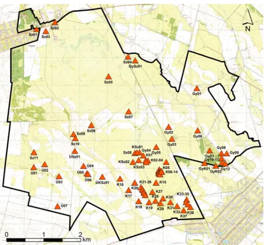
The landscape itself, which is outstanding from the point of view of natural protection as well, is varied and sometimes quite mosaic-like (Fig. 1.). Parallel ancient channels of the river Maros (Vizes-völgy, Apáti-ér, Szabadkai-ér, Nagy-Csattogó, Hajdú- völgy) cut through the terrain, with larger ridges and Pleistocene remnant surfaces between them (Gazdag 1960; Rónai & Fehérvári 1960; Rakonczai 1986a). In the central area of the plain, there are large salinized grasslands and marshes (alluvial basins), smaller loess meadow steppe fragments, in the periphery scattered arable lands, forests and smaller grasslands (Rakonczai 1986b; Kertész 2005; Kertész 2006).
Fig. 1.: The Kígyós-puszta area, part of the Körös-Maros National Park with the kurgans surveyed by Á. Bede (based on Bede 2016)
1. ábra: A Körös-Maros Nemzeti Park Kígyós-puszta területe a Bede Á. által felmért halmokkal (Bede 2016 nyomán)
Natural geological and geomorphological conditions must have played a crucial role in the selection and construction of the kurgan field (Dövényi et al. 1977). The mounds are usually lined up along the banks of former riverbeds and on the ridges that accompany them.
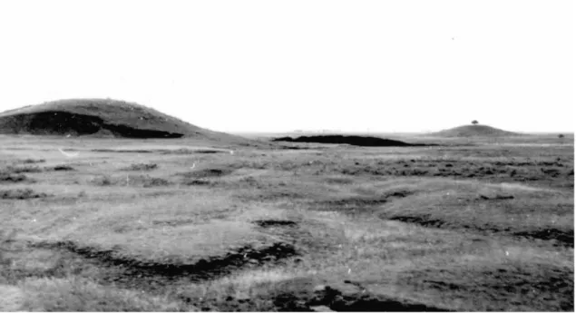
In addition to the highest mounds – the two Török- halom (Fig. 2.) and the Hegyes-halom – a number of medium-sized or lower kurgans were also raised in the area. On both the western and eastern side of the Szabadkígyós-Kétegyháza railway there are two groups of very small barrows. They could remain relatively intact because due to the poor quality of the saline soil, they were probably never ploughed, or they had only a very small amount of disturbance. The 18th-19th-century military, manor and cadastral maps indicate several mounds of the kurgan field, and regularly mark the mounds at border points (M. 1–8). This landscape has been intensively cultivated since the first half of the 18th century, following re-settlement after the Turkish
rule, and the extension of arable land has grown continuously, which has left a permanent mark on many mounds.
Archaeological aspects
The significance of the mounds in the vicinity of Kétegyháza, Gyula, Szabadkígyós and Újkígyós is outstanding because they can be found here in densities and clusters that we do not experience elsewhere in the Maros-Körös Interfluve. In total, more than one hundred mounds have been registered in this relatively small (4,779 ha), but well-defined area. Perhaps it was a clan or tribal burial ground, a sacral centre for the people of the Pit Grave Kurgans, who lived here more than five thousand years ago (Bede 2016, 82).
The abundance – in a regional comparison – of (temporary) surface waters in the region may have contributed to the unusual density of the mounds, which may be connected to the lifestyle and landscape use of the communities living here.
Fig. 2.: The two Török-halom kurgans on the saline grassland in Kétegyháza, 1967 (photo by Gy. Gazdapusztai;
MNM RégAd XVIII. 282/1967; Ecsedy 1979, 72, Pl. 4.1)
2. ábra: A déli és az északi Török-halom a kétegyházi szikes legelőn 1967-ben (Gazdapusztai Gy. felvétele;
MNM RégAd XVIII. 282/1967; Ecsedy 1979, 72, Pl. 4.1)
Fig. 3.: The northern and the cut southern Török-halom kurgans in 1969–1971 (M.13). Scale of original map 1:10,000
3. ábra: Az északi és az átvágott déli Török-halom 1969–1971-ben (M.13). Eredeti térkép méretaránya 1:10 000
In 1966–1968, Gyula Gazdapusztai excavated 17 burials in 11 kurgans near Kétegyháza, and the results were later published by István Ecsedy (Gazdapusztai 1966; Gazdapusztai 1967;
Gazdapusztai 1968; Ecsedy 1979, 20–33). The Holocene palaeosoils under, and the material of the kurgans contained the artefacts of the Middle Copper Age Bodrogkeresztúr and Boleráz Cultures;
the communities of later times (Scythians, Sarmatians) also buried into the mounds, and some central tombs were robbed during the Migration Period (Ecsedy 1973; Ecsedy 1979, 20–33). It is typical of the excavation methods of the time that several mounds could be excavated only at the price of being fully or partially destroyed, and many kurgans still bear the traces of the archaeological research fifty years ago (their central part is dug up, cut longitudinally, and the earth is still placed on the sides). Unfortunately, the removed soil was never reburied in any of the cases. The reconstruction of these mounds would require a targeted program with the help of a project grant.
The largest mound of the kurgan field is the southern Török-halom, which was almost completely destroyed by the local cooperative in the 1960s to fill up the streets in the centre of the village, leaving only a small part of its western periphery. Thanks to the excavation, we know its structure well: the barrow was the burial place of the Late Copper Age/Early Bronze Age people of the Pit Grave Kurgans containing four burials, raised in three different, consecutive periods (3000–
2700 Cal BC). The timber framed burial chamber of the central burial, as well as the imprints of mats, furs and textiles in it, could be observed; a pair of silver hair rings, a necklace of animal teeth, an amulet, and red ochre paint containing iron oxide used for the ceremony were among the grave goods of the deceased, who had been buried with raised legs (Ecsedy 1979, 21–23; Horváth 2011, 92; Dani
& Horváth 2012, 76).
The two Török-halom kurgans in the landscape
The northern kurgan
The main morphometric data of the northern Török- halom left in its original state are as follows.
Central coordinates: WGS84 46°33’01.44”
(46.550407) N, 21°08’31.44” (21.142058) E (Google Earth), EOV 810,618, 136,155 (EOTR 38- 424; M.14); relative height: 5 m; absolute (altitude) height: 96.1 m; diameters: 58 m and 52 m.
Perimeter: 218 m. Floor area: 3,670 m2.
19th-21st-century printed maps also show the mound with its altitude above the Adriatic, and from 1953 the Baltic Sea. These are in chronological order:
53.1 fathom (100.7 m) (M.5), 97 m (M.5), 52.1 fathom (98.8 m) (M.6–8), 98 m (M.4; M.10), 96.2
m (M.11; M.15), 96.2/95.8 m (M.12), 95.9 m (M.14), 96.6 m (M.16–17). Toponym on maps:
Török-hlm. (M.13–14; M.16–17).
The entire surface of the Török-halom is registered as grassland (pasture) with regard to type of exploitation. Topographical lot numbers: 0213/2, 0223/12. Interestingly, the dividing line between the two parcels is still the same as the late Medieval settlement boundary.
The third-rank triangulation base point on the top (plateau) of the mound was made permanent in 1981; its official number: 38-4234 (FÖMI). Due to lack of maintenance, it has been slightly damaged by now, the central vertical concrete element is loosened, but the square-shaped concrete cover is firmly fixed. The installation of such a base point – especially in the case of smaller mounds – can cause more serious damages, as the central part of the mound is dug up 1.5–2 m deep and 1–1.5 m wide and is then reburied.
Its name probably derives from the once well- known folk tradition that the mounds of the Great Hungarian Plain were human creations, raised during the Turkish rule, and according to legends, they were typically sentry points, messaging places, resting places, or burial sites. After the Turkish period, it was self-evident for the people – often of foreign origin – who had returned to the depopulated plain to link the already existing mounds to the Turkish world (Krupa 1981, 75).
It was probably a Late Medieval (16th-17th century), old border point, later a county border point between Kétegyháza village (Blazovich 1996, 159–
160) and Kakucs territory (Blazovich 1996, 145–
146), and between Békés and Arad Counties. (It is another Kakucs settlement, not the village which exists today in Pest County.) Since 1950 it belongs entirely to the administrative area of Kétegyháza.
There was probably a boundary hill on the top (M.2; M.5–8), which is no longer present today.
The first (1783), the second (1860), the third military surveys (1884), the cadastral map of 1884, the 1884 census and the 1943 topographic map show it with Lehmann type hachures or in outline (M.1; M.3–5; M.7–9). In the 1884 cadastre map and in the military maps of 1950, 1955, 1982, 1991 and 2002 it is indicated as an elevation point (M.6;
M.10–11; M.15–17), while in the 1969 and 1980 1:10,000 maps show detailed contours (M.13–14).
Each map consistently displays it as on grassland.
In the 1960s and 1970s, a tree was standing on the top of the mound (Fig. 2-3.; Dövényi et al. 1977, 9.
kép; M.13–14). Apart from this, it was probably always covered by dry grassland, with a loess meadow steppe character, although due to the use and intensive exploitation of the area, both the vegetation and the shape of the mound could have
been affected by various disturbances (traces of diggings, foxholes, etc.). Although the barrow itself was probably never ploughed, the geomorphologic prominent parts of its immediate surroundings (loess hills) were already cultivated or used as a settlement in the Copper Age (Bodrogkeresztúr Culture), and later cultivation was expanded into even larger areas (e.g. by the Scythians, Celts, Sarmatians, Late Medieval Hungarians; based on data of Ecsedy 1979).
Even today, it is a huge, imposing mound of regular shape, impressive size and fundamentally intact structure, dominating the landscape in the plain grassland (Fig. 4.). This is the largest of the mounds preserved in their original state, and still in good condition today (Fig. 5.). All around it, the traces of a deeper area can be followed, from which the material of the mound was extracted in the Late Copper Age (these areas are now partly filled, typically marshy, swamp habitats) (Fig. 6-7.).
The bottom of the kurgan is eroded around the perimeter, and alkaline benches are forming. On its sides, there are traces of mild disturbances, such as a small scoop on its eastern slope (perhaps traces of the pit of a former treasure hunter or a foxhole/badger sett). The top of the kurgan is flat, suggesting that it was cut off in later periods.
A clearly marked boundary ditch and a rampart raised from the earth of the ditch runs from the
south and from the north to the periphery of the kurgan, but it does not continue in the central part of the mound. The ditch and the rampart are most likely to have been built in the 17th-18th century; it has outstanding landscape value due to its historical connections. Unfortunately, in the 1970s, a drainage channel, now called Kígyósi-főcsatorna (or Kétegyházi-árapasztó) was dug in the other parts of the ditch (M.14).
The loess vegetation of the Török-halom, now surrounded by saline grassland, is not considered to be of outstanding naturalness (Medovarszky 2010), due to the hundreds of years of exploitation (grazing) and other disturbances, yet it can be considered to be rich in plant species. Most of the prehistoric monument is covered by generalist loess meadow steppe species and less ruderal weeds, but some species do occur that have floristic or nature conservation value; for example Ranunculus illyricus, Rosa rubiginosa s.l., Ononis spinosiformis subsp. semihircina, Stachys germanica and Carthamus lanatus.
Its surface – and vegetation – do not require any special nature conservation interventions, but over the long term moderate grazing or mowing and, possibly intermittently and partially, burning should be solved (there has been no stable, established practice over the past decades, but forward-looking initiatives have been taken by the local nature conservation ranger).
Fig. 4.: The northern Török-halom kurgan in 2017 (photo by Á.
Bede)
4. ábra: Az északi Török-halom 2017-ben (Bede Á. felvétele)
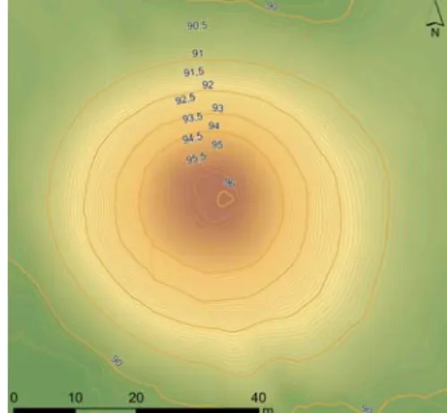
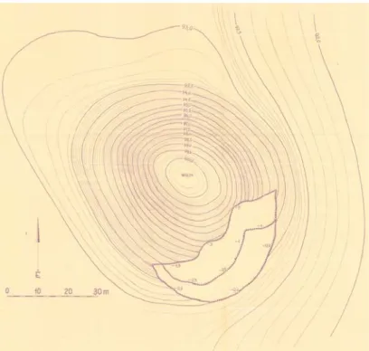
Fig. 5.: Contour surveying map of the northern Török-halom kurgan
5. ábra: Az északi Török-halom szint- vonalas felmérése
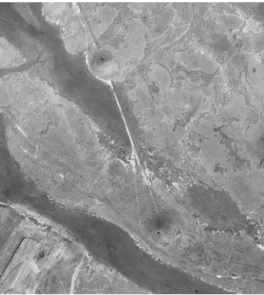
Fig. 6.: An aerial photo of the two Török-halom kurgans in 1962, between the mounds with Medieval border ditch (Fentről.hu)
6. ábra: A két Török-halom 1962-es légifotója, közöttük a középkori eredetű határárokkal (Fentről.hu)
Fig. 7.: An orthophoto of the northern Török-halom kurgan in 2011 (FÖMI)
7. ábra: Az északi Török-halom ortofotója 2011-ből (FÖMI)
The southern kurgan
In general, the overall picture of the northern mound is also valid for the southern one. The surface of this kurgan also evolved in a dry grassland environment over the past five thousand years, their archaeological aspects are also common, and their form and appearance were similar. Therefore, we are going to focus only on those significant and unique features that are fundamentally different in the (landscape) history of the two mounds.
The main morphometric data of the southern Török-halom kurgan before its destruction. Central coordinates: WGS84 46°32’51.32” (46.547241) N, 21°8’35.74” (21.143524) E (Google Earth), EOV 810,731, 135,839 (EOTR 38-442; M.14); relative height: 6.7 m. Absolute (altitude) height: 98.5 m (M.11–12), 97.8 m (M.13). Diameters: 74 m and 64 m. Perimeter: 220 m. Floor area: 3,770 m.
Toponym on map: Török-hlm. (M.14).
A useful contour-map of its original shape was made in 1966 by Gyula Gazdapusztai and József Tóth (Fig. 8.; Gazdapusztai & Tóth 1966; MNM RégAd XVIII. 282/1967; Ecsedy 1979, 21, Fig. 8).
In the course of the excavation in 1967, the centre of the kurgan was completely cut through, and its cross-section and the thickness of its layers were published by István Ecsedy (Fig. 9.; Ecsedy 1979, 24, Fig. 13–14).
The (rescue) excavation took place because the cooperative of Kétegyháza began to carry away the material of the kurgan to fill up the streets of the village; its south-eastern side had already been disturbed (Fig. 8., 10.). An aerial photo taken in 1962 already shows the destruction (Fentről.hu), but in 1953 it was not yet visible (Military History Map Collection, L-34-55-A-d). In the course of the excavation, the high-performance machines took out hundreds of cubic meters of earth from the central part of the kurgan within a few weeks, cutting a thick strip into its centre (Fig. 3.). For years after the documented archaeological work, the locals had been carrying away the earth from the mound (Fig. 11.), until it disappeared almost completely. In the spring of 2011, there was still a 1.2-meter-high “in situ” piece on its western periphery, with dugouts and smaller piles of earth in the central part of the mound (Fig. 12.). Despite its almost complete destruction, the outline of its location was still visible, with only a few Elaeagnus angustifolia trees standing on it.
After the excavation and destruction – and even today – the Late Medieval boundary ditch between the two mounds (Fig. 6.), which separated the administrative areas of Kétegyháza village and Kakucs territory (“puszta”) until 1947 (Németh 2002, 81), is easily discernible. However, just to the south of the mound the line of the ditch becomes uncertain.
Fig. 8.: Original contour surveying map of the southern Török-halom kurgan in 1966 (MNM RégAd XVIII.
282/1967)
8. ábra: A déli Török-halom eredeti szintvonalas felmérése 1966-ból (MNM RégAd XVIII. 282/1967)
Fig. 9.: The cross-sectional profile interpretation of the excavated southern Török-halom kurgan (Ecsedy 1979, 24, Fig. 13–14)
9. ábra: A feltárt déli Török-halom értelmezett keresztmetszeti szelvényrajzai (Ecsedy 1979, 24, Fig. 13–14)
Fig. 10.: The injured southern Török-halom kurgan before the archaeological excavation in 1967 (photo by I. Ecsedy; MTA RégInt, Photographs 10.231)
10. ábra: A megbontott déli Török-halom a régészeti feltárás előtt, 1967-ben (Ecsedy I. felvétele; MTA RégInt Fotótára 10.231)
Fig. 11.: The damaged southern Török-halom kurgan in the 1970s (Dövényi et al. 1977, Fig. 7)
11. ábra: A déli Török-halom torzója az 1970-es évek első felében (Dövényi et al. 1977, 7. kép)
Fig. 12.: The site of the destroyed southern Török-halom kurgan with original bottom parts on the right side of the picture (photo by Á. Bede, 2011)
12. ábra: Az elhordott déli Török-halom helye, a kép jobb oldalán „in situ” lábi részekkel (Bede Á. felvétele, 2011)
Fig. 13.: The rebuilt southern Török-halom kurgan in 2011, Autumn (photo by B. Forgách) 13. ábra: A frissen újraépített déli Török-halom 2011 őszén (Forgách B. felvétele)
The rebuilding of the southern kurgan was part of the regional habitat conservation and restoration concept of the Körös-Maros National Park Directorate, and was completed in July-August 2011 after a long planning phase (Fig. 13.; Nagy 2012, 99–100). To this end, the shape and morphological character of the northern Török- halom were used, adapted to the dimensions of the former mound. Although the survey of the original mound from 1966 was available (Gazdapusztai &
Tóth 1966; MNM RégAd XVIII. 282/1967; Ecsedy 1979, 21, Fig. 8), this source was unfortunately not known by the designers and was not taken into account. Unfortunately, during the construction, the
“in situ” periphery was covered with earth in a large area, thus not only the last remains of the original point were destroyed, but a part of the residual loess vegetation was also lost.
Originally, the southern kurgan could have vegetation similar to that of the northern one (Medovarszky 2010; Nagy 2012, 97–98). We can deduce this primarily from the small loess grassland patch on the preserved part at the periphery of the mound. After the reconstruction, the experts of the national park tried to reconstruct the natural habitat by using rescued turf and sowing indigenous species on the surface of the kurgan (Nagy 2012, 100–101). From the loess surface of the original destroyed mound, 6 pieces of turf blocks (approx.
1.5×3 meters and 40 cm deep) covered with loess meadow steppe vegetation were picked up by the workers of the Körös-Maros National Park Directorate with construction machinery before the rebuilding. The turf blocks were put in a nearby place during the work, and at the end of the reconstruction these blocks were take back to the surface of the rebuilt cylinder at the same distances, 1-2 meters above the bottom of the kurgan. In addition, two bags of hand-picked seeds of Agropyron cristatum (from the Gödény-halom kurgan near Békésszentandrás) were sprinkled on the mound body by the staff of the national park in the same year. They also sowed seeds collected from the Tompapusztai-löszgyep loess meadow steppe grassland near Battonya, the colonization of some species (Linum austriacum, Teucrium chamaedrys, Onobrychis arenaria, and Salvia nemorosa) were surely successful (Judit Sallainé Kapocsi’s written communication).
Discussion
Typically, landscape historical studies are carried out on a smaller or larger, but mostly well-defined landscape, region, or larger scale landscape, as their historical aspects can be grasped well and the trends of change can be consistently described (Molnár &
Biró 2011; Molnár & Biró 2017). However, in our opinion, it is worth examining the historical changes of the landscape at a smaller scale as well, even through features of smaller sizes. These
include point or line like features of anthropogenic origin, raised in archaeological periods, such as tells, mounds, ramparts and fortified settlements.
Their micro-level research or large-scale comparative investigation and comparison with other archaeological sites can also produce important results (Saláta et al. 2017).
In the Tiszántúl region, pairs of kurgans (double mounds) are quite frequent. The pair typically consists of a larger and a much smaller mound, or two mounds of approximately the same size (Bede 2016, 36–37). In our case, we can speak of two impressive, large kurgans surrounded by smaller mounds in rows and groups. The southern Török- halom was larger (higher and wider), but the size of the northern one was not far behind.
Despite the difficulties outlined, the reconstruction work of the southern Török-halom mound has a great importance, since previously a kurgan of this size had never been rebuilt (we are not aware of a similar case). According to the goals of the national park – with the aim of landscape rehabilitation – other, smaller, damaged mounds will also be restored.
Acknowledgements
We would like to say thank you for the professional support to Körös-Maros National Park Directorate (Szarvas), as well as for the cooperation and help to István Ecsedy, László Tirják, Péter Bánfi, János Greksza, Balázs Forgách, Ábel Péter Molnár, Tünde Horváth, and Judit Sallainé Kapocsi. The paper was supported by the postdoctoral scholarship (PD 121126) of the National Research, Development and Innovation Office (Budapest).
Abbreviations
ARCHIVES OF BÉKÉS COUNTY: Archives of Békés County (A Magyar Nemzeti Levéltár Békés Megyei Levéltára), Gyula.
MILITARY HISTORY MAP COLLECTION:
Museum of Military History, Military History Map Collection (Hadtörténeti Intézet és Múzeum Hadtörténeti Térképtára), Budapest.
MOL: National Archives of Hungary (Magyar Nemzeti Levéltár Országos Levéltára), Budapest.
MNM RégAd: Archaeological Repository of Hungarian National Museum (Magyar Nemzeti Múzeum Régészeti Adattára), Budapest.
MTA RégInt: Hungarian Academy of Sciences, Research Centre for the Humanities, Institute of Archaeology (Magyar Tudományos Akadémia, Bölcsészettudományi Kutatóközpont Régészeti Intézete), Budapest.
References
ARDELEAN, J. J. (1986): Kétegyháza község monográfiája (Monographia comunii Chitichaz).
Bibliotheca Bekesiensis 27 Békéscsaba, Rózsa Ferenc Gimnázium. 117 pp.
BEDE, Á. (2016): Kurgánok a Körös–Maros vidékén… Kunhalmok tájrégészeti és tájökológiai vizsgálata a Tiszántúl középső részén (Kurgans in the land of the Körös and Maros rivers…
Landscape archaeological and landscape ecological investigations on mounds in the central part of the Tiszántúl region, Hungary). Budapest, Magyar Természettudományi Társulat. 150 pp.
BÉKÉS MEGYE (2009): Békés megye. 1882–1887.
1:2880. Georeferált vármegyei kataszteri térképek.
Budapest, Békés Megyei Levéltár, Arcanum. DVD- ROM.
BLAZOVICH, L. (ed.) (1996): A Körös–Tisza–
Maros-köz települései a középkorban. Dél-alföldi Évszázadok 9 Csongrád Megyei Levéltár, Szeged.
355 pp.
DANI, J. & HORVÁTH, T. (2012): Őskori kurgánok a magyar Alföldön. A Gödörsíros (Jamnaja) entitás magyarországi kutatása az elmúlt 30 év során. Áttekintés és revízió. Budapest, Archaeolingua Alapítvány. 215 pp.
DEÁK B. (2018): Természet és történelem. A kurgánok szerepe a sztyeppi vegetáció megőrzésében. Budapest, Ökológiai Mezőgazdasági Kutatóintézet. 150 pp.
DEÁK, B., TÓTHMÉRÉSZ, B., VALKÓ, O., SUDNIK-WÓJCIKOWSKA, B., MOYSIYENKO, I. I., BRAGINA, T. M., APOSTOLOVA, I., DEMBICZ, I., BYKOV, N. I. & TÖRÖK, P.
(2016): Cultural monuments and nature conservation: A review of the role of kurgans in the conservation and restoration of steppe vegetation.
Biodiversity and Conservation 25 2473–2490.
DÖVÉNYI, Z., MOSOLYGÓ, L., RAKONCZAI, J. & TÓTH, J. (1977): Természeti és antropogén folyamatok földrajzi vizsgálata a kígyósi puszta területén (Geographical survey of natural anthropogen processes on the puszta Kígyós).
Békés Megyei Természetvédelmi Évkönyv 2 43–72., 161–163., 174–176.
ECSEDY, I. (1973): Újabb adatok a tiszántúli rézkor történetéhez (New data on the history of the copper age in the region beyond the Tisza). A Békés Megyei Múzeumok Közleményei 2 3–40.
ECSEDY, I. (1979): The People of the Pit-Grave Kurgans in Eastern Hungary. Fontes Archaeologici Hungariae. Budapest, Akadémiai Kiadó, 1–85.
ELSŐ KATONAI FELMÉRÉS (2004): Az első katonai felmérés. A Magyar Királyság teljes
területe 965 nagyfelbontású színes térképszelvényen. 1782–1785. Budapest, Arcanum Kiadó. DVD-ROM.
GAZDAG, L. (1960): Régi vízfolyások és elhagyott folyómedrek Orosháza környékén (Alte Wasserläufe und verlassene Flussbetten in der Umgebung von Orosháza). A Szántó Kovács Múzeum Évkönyve 1960 257–306.
GAZDAPUSZTAI, GY. (1966): Zur Frage der Verbreitung der Sogenannten „Ockergräberkultur”
in Ungarn. A Móra Ferenc Múzeum Évkönyve 1964–1965/2 31–37.
GAZDAPUSZTAI, GY. (1967): Chronologische Fragen in der Alfölder Gruppe der Kurgan-kultur. A Móra Ferenc Múzeum Évkönyve 1966–1967/2 91–
100.
GAZDAPUSZTAI, GY. (1968): A „kunhalmok”.
Az őskor érdekes vallástörténeti emlékei.
Világosság 9 399–401.
GAZDAPUSZTAI, GY. & TÓTH, J. (1966):
Előzetes beszámoló a kétegyházi (Békés m.) halommező szintezési munkálatairól. Manuscript.
Szeged. 11 pp. Archaeological Repository of Móra Ferenc Museum (Móra Ferenc Múzeum Régészeti Adattára), Szeged 6797-2016.
HARMADIK KATONAI FELMÉRÉS (2007): A Harmadik Katonai Felmérés. 1869–1887 (The Third Military Survey. 1869–1887). Budapest, Arcanum Kiadó. DVD-ROM.
HORVÁTH, T. (2011): Hajdúnánás–Tedej–
Lyukas-halom – An interdisciplinary survey of a typical kurgan from the Great Hungarian Plain region: a case study. (The revision of the kurgans from the territory of Hungary). In: PETŐ, Á. &
BARCZI, A. (eds.): Kurgan Studies. An environmental and archaeological multiproxy study of burial mounds in the Eurasian steppe zone.
British Archaeological Reports International Series 2238 Oxford, Archaeopress. 71–131.
KERTÉSZ, É. (2005): A szabadkígyósi Kígyósi- puszta védett terület flórája. Natura Bekesiensis 7 5–22.
KERTÉSZ, É. (2006): A szabadkígyósi Kígyósi- puszta növényzete (Vegetation of the „Kígyós- puszta”). A Békés Megyei Múzeumok Közleményei 28 17–40.
KRUPA, A. (1981): Újkígyósi mondák és igaz történetek. Békéscsaba, Békés megyei Tanács VB Művelődésügyi Osztálya. 307 pp.
MAGYARORSZÁG TOPOGRÁFIAI TÉRKÉPE (2008): Magyarország topográfiai térképe a második világháború időszakából: Topographic maps of Hungary in the period of the WWII.
Budapest, Arcanum. DVD-ROM.
MÁSODIK KATONAI FELMÉRÉS (2005): A második katonai felmérés. 1819–1869. A Magyar Királyság és a Temesi Bánság nagyfelbontású, színes térképei: The second military surveying.
Colour map sections of Kingdom of Hungary and Temes. 1819–1869. Budapest, Arcanum Kiadó.
DVD-ROM.
MEDOVARSZKY, M. (2010): Az Elek–
Kétegyháza–Szabadkígyós térségében levő kunhalmok természetvédelmi értéke. Thesis.
Manuscript. Debrecen. 122 pp.
MOLNÁR, Á. & BIRÓ, M. (2017): A Körös-Maros Nemzeti Park Kígyósi-puszta országos jelentőségű védett terület élőhely-térképezése. Research report.
Manuscript. 187 pp. Research Library of Körös- Maros National Park Directorate (Körös-Maros Nemzeti Park Igazgatóság Kutatási Könyvtára), Szarvas 1353.
MOLNÁR, Zs. & BIRÓ, M. (2011): A Duna–Tisza köze és a Tiszántúl természetközeli növényzetének változása az elmúlt 230 évben: összegzés tájökológiai modellezések alapozásához. In:
RAKONCZAI, J. ed., Környezeti változások és az Alföld. Nagyalföld alapítvány kötetei 7 Békéscsaba, Nagyalföld Alapítvány. 75–85.
NAGY, I. (2012): A kétegyházi Török-halom rekonstrukciója (Restoration of Török-halom kurgan near Kétegyháza). A Békés Megyei Múzeumok Közleményei 36 87–108.
NÉMETH, CS. (2002): Változatos évtizedek. In:
ERDMANN, Gy. ed., Kétegyháza. Budapest, Száz magyar falu könyvesháza Kht. 77–90.
RAKONCZAI, J. (1986a): A szabadkígyósi puszta földtani viszonyai és geomorfológiája (The geological conditions and the geomorphology of the Szabadkígyós steppe). Környezet- és Természetvédelmi Évkönyv 6 7–18.
RAKONCZAI, J. (1986b): A Szabadkígyósi Tájvédelmi Körzet talajviszonyai (The ephadic conditions of the Szabadkígyós Landscape Protection Area). Környezet- és Természetvédelmi Évkönyv 6 19–42.
RÓNAI, A. & FEHÉRVÁRI, M. (1960): Kísérlet az Alföld részletes földtani térképezésére Szabadkígyós környékén. A Magyar Állami Földtani Intézet Évi Jelentése az 1957–1958. évről 135–163.
SALÁTA, D., KRAUSZ, E. & PETŐ, Á. (2017):
Régészeti lelőhelyek előzetes állapotfelmérése történeti források alapján (Preliminary assessment of the condition of archaeological sites on the basis of historical sources). In: BENKŐ, E., BONDÁR, M. & KOLLÁTH, Á. (eds.): Magyarország Régészeti Topográfiája: múlt, jelen, jövő (Archaeological Topography of Hungary. Past, present and future). Budapest, MTA BTK
Régészeti Intézet, Archaeolingua Alapítvány. 359–
367.
TÓTH, A. (2011): Requiem for kurgans. In: PETŐ, Á. & BARCZI, A. (eds.): Kurgan Studies. An environmental and archaeological multiproxy study of burial mounds in the Eurasian steppe zone.
British Archaeological Reports International Series 2238 Oxford, Archaeopress. 1–5.
TÓTH, CS. A., RÁKÓCZI, A. & TÓTH, S. (2018):
Protection of the state of prehistoric mounds in Hungary: Law as a conservation measure.
Conservation and Management of Archaeological Sites 20 113–142.
Internet-based references
FENTRŐL.HU: Aerial photo collection of Budapest Metropolitan Government Office, Surveying, Remote Sensing and Land Registry Department (Budapest Főváros Kormányhivatal Földmérési, Távérzékelési és Földhivatali Főosztálya). Internet: https://www.fentrol.hu, October 31, 2018.
FÖMI: Data provider web site of Budapest Metropolitan Government Office, Surveying, Remote Sensing and Land Registry Department (Budapest Főváros Kormányhivatal Földmérési, Távérzékelési és Földhivatali Főosztálya).Internet:
http://geoshop.hu December 31, 2018.
GOOGLE EARTH: Google Earth Pro online GIS application. https://www.google.hu/intl/hu/earth December 31, 2018.
Maps
M.1: First military surveying map. 1783. 1:28,800.
C. XXII. S. XVIII (Military History Map Collection; published: Első katonai felmérés 2004).
M.2: “Hydrographia depressae Regionis fluviatilis Crisiorum, Magni, Albi, Nigri, Velocis, Parvi, Fl.
Berettyó”. 68 sections. 1822. 1:36,000. Mátyás Huszár (MOL S 80. Körösök 39).
M.3: Second military surveying map. 1860.
1:28,800. S. 58. C. XLI. (Military History Map Collection; published: Második katonai felmérés 2005).
M.4: Third military surveying map. 1884. 1:25,000.
5366/4 (Military History Map Collection;
published: Harmadik katonai felmérés 2007).
M.5: “KÉTEGYHÁZA / nagy község / felvételi előrajzai / 1884”. 1:2,880. Manó Kerausch, Antal Witlaczil (MOL S 79. 202/5. 5. page).
M.6: “KÉTEGYHÁZA / nagyközség / Békés megyében / 1884”. 1:2,880. Manó Kerausch (MOL S 78. 49. box, Kétegyháza, 5. page).
M.7: Cadastral map of Kétegyháza. 1:2,880. 1884 (published: Békés megye 2009).
M.8: “ELEK II. RÉSZ / vagyis / Bánkut, Eperjes és Kakucs / pusztaadóközség / Arad megyében / 1885.”. 1:2,880. Mihály Schatteles, Vilmos Kutscher (Archives of Békés County BmK 44/44.;
published: Békés megye 2009).
M.9: Military map. 1943. 1:50,000. 5366 K (Military History Map Collection; published:
Magyarország topográfiai térképe 2008).
M.10: Military map. 1950. 1:25,000. L-34-55-A-d (Military History Map Collection).
M.11: Military map. 1955. 1:25,000. L-34-55-A-d (Military History Map Collection).
M.12: Military map. 1965. 1:50,000. L-34-55-A (Military History Map Collection).
M.13: Military map. 1969–1971. 1:10,000. 710-141 (Military History Map Collection).
M.14: Unified National Cartography System (Egységes Országos Térképrendszer, EOTR). 1980.
38-424 (FÖMI).
M.15: Military map. 1982–1983. 1:25,000. L-34- 55-A-d (Military History Map Collection).
M.16: Military map. 1991. 1:25,000. L-34-55-A-d (Military History Map Collection).
M.17: Military map. 2002. 1:50,000. L-34-55 (Military History Map Collection).