INFOCOMMUNICATIONS JOURNAL
MARCH 2021 • VOLUME XIII • NUMBER 1 45
Traffic congestion propagation identification method in smart cities
Traffic congestion propagation identification method in smart cities
Attila M. Nagy, and Vilmos Simon
Attila M. Nagy is with the Department of Networked Systems and Services, Faculty of Electrical Engineering and Informatics, Budapest University of Techonolgy and Economics, Hungary, e-mail: anagy@hit.bme.hu.
Vilmos Simon is with the Department of Networked Systems and Services, Faculty of Electrical Engineering and Informatics, Budapest University of Techonolgy and Economics, Hungary, e-mail: svilmos@hit.bme.hu.
INFOCOMMUNICATIONS JOURNAL 1
Traffic congestion propagation identification method in smart cities
Attila M. Nagy, Vilmos Simon
Abstract—Managing the frequent traffic congestion (traffic jams) of the road networks of large cities is a major challenge for municipal traffic management organizations. In order to manage these situations, it is crucial to understand the processes that lead to congestion and propagation, because the occurrence of a traffic jam does not merely paralyze one street or road, but could spill over onto the whole vicinity (even an entire neighborhood).
Solutions can be found in professional literature, but they either oversimplify the problem, or fail to provide a scalable solution.
In this article, we describe a new method that not only provides an accurate road network model, but is also a scalable solution for identifying the direction of traffic congestion propagation.
Our method was subjected to a detailed performance analysis, which was based on real road network data. According to testing, our method outperforms the ones that have been used to date.
Index Terms—congestion propagation, frequent propagation trees, traffic study, city planning
I. INTRODUCTION
One of the major problems of traffic in big cities around the world is the phenomenon of traffic congestion (traffic jams) on the road network. Traffic jams have a serious effect not only on the lives of drivers, but also on every city inhabitant.
Traffic jams increase not only energy and fuel consumption [1], but also harmful emissions [2]. According to a laboratory testing [3], congestion-related emissions cause increased cases of allergies and exacerbate existing conditions among people who are sensitive to it. Additionally, other research [4] shows that traffic jams raise the risk of heart attack. That is why attention needs to be paid to avoiding traffic jams and possibly eliminating them, because in addition to significant economic costs [5], they are also harmful to the health of city inhabitants (which can also be expressed as a financial costs for health insurers).
Intelligent city management systems can provide a solution to these problems, or at least substantially reduce the negative effects on the daily life of city dwellers. It is the task of these systems to continually monitor the traffic and to provide information on the basis of the collected data, as well as to manage the automated allocation of resources [6], for example, opening new lanes or closing them, adapting traffic lights to current traffic conditions [7] or assisting route planning applications with accurate forecasts.
Attila M. Nagy is with the Department of Networked Systems and Services, Faculty of Electrical Engineering and Informatics, Budapest University of Techonolgy and Economics, Hungary, e-mail: anagy@hit.bme.hu.
Vilmos Simon is with the Department of Networked Systems and Services, Faculty of Electrical Engineering and Informatics, Budapest University of Techonolgy and Economics, Hungary, e-mail: svilmos@hit.bme.hu.
In the first generation of the intelligent traffic management systems, the utilized data sources were different type of pres- ence sensors in fixed positions, which were able to detect the presence of nearby vehicles. Initially, inductive loop detectors were the most popular, but nowadays, a wide variety of sensors became available such as traffic cameras, laser radar sensors or microwave radar sensors [8], [6]. Recently, the advent of GPS equipped smartphones and vehicles has given rise to a relatively new type of data source that could supplement presence type sensors to gather more detailed information or to get data about the roads, which have not been covered with presence sensors yet. In addition to existing data sources, the emerging Vehicle to Everything (V2X) communication technologies [9], [10] will become a vital data source in the future that can improve the performance of intelligent traffic management systems. The V2X defines messaging protocols to communicate between cars and the infrastructure. The V2X protocols are already integrated into the newest vehicles, but the number of equipped vehicles is still low; thus, the role of V2X will be more significant in future applications.
When a traffic jam starts to develop on a segment of the road network, it often also affects the surrounding road segments of the network. These effects are complicated - they always depend on current environmental factors (time of day, weather, holidays, etc.) but if we examine properly chosen time periods, we can collect useful information. The information gathered could make the operation of intelligent city management systems more efficient and provide new data to city planners and managers.
There are several studies exploring the propagation of the effects of developing traffic jams, which face a number of significant challenges. The first is that the road networks of large cities form an extensive and complex system in which the study of the traffic jam propagation is difficult to scale.
Several studies have developed alternative models for solving the problem, but these oversimplify the road network, and so the output of their methods are imprecise. The second challenge is that it is not enough to detect a traffic jam, it is also important be able to identify the relationships between the road segments.
In this article, we would like to present a new method we have developed, which takes into account the spatial and temporal relationships:
1) is able to identify the appearance of congestion propa- gation across the entire road network in a scalable way, 2) is able to identify frequently occurring traffic jam prop- agation within these (the importance of which will be explained later).
DOI: 10.36244/ICJ.2021.1.6
MARCH 2021 • VOLUME XIII • NUMBER 1 46
INFOCOMMUNICATIONS JOURNAL
Traffic congestion propagation identification method in smart cities
INFOCOMMUNICATIONS JOURNAL 2
The output of the process can be used by city traffic manage- ment system operators to map the source and propagation of frequently occurring traffic jams, and identify bottlenecks of the road network, which can be used in city traffic network planning and real-time interventions (if they have an Intelligent Transportation System (ITS) system). The output can be useful for route planning methods and can be used to refine forecasts of traffic prediction methods as well.
The remainder of this article contains the following chap- ters. Section II summarizes what research has been done in this field to date. In Section III, we introduce a new definition for traffic jams that, unlike the definition used in previous research, does not require manual parameter setting.
We then introduce our developed congestion propagation detection method in Section IV and we perform a detailed performance analysis in Section V. We end the article with a short conclusion in the Section VI.
II. RELATED RESEARCH
A. Congestion occurrence
To be able to reliably identify a traffic jam occurrence from traffic data, you first need to define exactly what a traffic jam is. Traffic jam definitions are not uniform in the literature [11], and they often depend to a large extent on empirically set parameters.
Methods found in the literature, which are used to explore the propagation of traffic jams or predict traffic congestions rely almost exclusively on the speed data to determine the size of a traffic jam. In addition, we have also found other definitions from related researches that use other types of data.
The definitions can be separated into three main categories:
• speed-based methods,
• travel time-based methods,
• volume-based methods.
The speed-based methods can be separated to threshold- based and ratio-based subcategories. In the case of threshold- based methods [12], [13], [14], the researchers manually, in advance, determine the possible traffic states (typically 4-5 traffic classes) and their associated boundaries. Then the mea- sured speed data is categorized into the defined traffic classes.
As an extension, the authors of [15] defined the boundaries between traffic classes as fuzzy and also incorporated other coefficients such as traffic volume.
The ratio-based methods [16], [17], [18], [19], [20], [13], [21] do not determine velocity limits but numbers in a ratio.
They compare the current measured speeds with the previously measured average or free-flow speeds. The free-flow is the speed at which the vehicle drivers would be able to travel if unimpeded by other vehicles [22]. In the literature, we have found two ways to determine thefree-flow speed. The Speed Reduction Index (SRI) definition [23], [24] uses the 85th percentile of the off-peak speed, while the Speed Performance Index (SPI) definition [24] applies the maximum permissible road speed.
If the ratio of current speed to the average (free-flow) speed is lower than the pre-determined ratio, then the current measured speed is considered a traffic jam situation, that is,
based on the velocities measured in the area, they determine that a traffic jam has occurred. Some methods [16], [13], [24]
define more than one traffic class. In these cases, different ratios are established for every traffic class.
The travel time-based methods use probe vehicle data to determine the congestion level of the examined road segments.
The Travel rate method [25] calculates the ratio of the current segment travel time and the segment length to quantify the congestion level. The Delay rate [26], [25] and Delay ratio [26], [25] methods are the extensions of the Travel rate method where the measured travel rate is compared with a predefined acceptable travel rate value. The Relative Congestion Index (RCI) definition [27] relies on the ratio of the current mea- sured travel time and thefree-flow travel time. The free-flow travel time can be calculated with the ratio of the road segment length andfree-flow.
The volume-based methods examine the traffic volume that denotes the number of passing vehicles in predefined time frames. A well-known volume-based method is the Volume to Capacity (V/C) ratio definition [28] that compares the measured volume with the maximum number of vehicles that a segment can handle within its capacity. The V/C ratio is often used together with the Level of Service (LOS) [29] where the measured V/C ratio values are classified in 6 traffic classes.
Using the criteria of a good congestion measure from article [11], the majority of these methods’ weak point is that they only take one data type into consideration, and except for some definitions [24], [28], do not describe the state of the traffic appropriately because the occurrence of the traffic jam always depends on the properties of the road segment as well. For example, the number of lanes, the speed limits for a given segment of road, the number of vehicles passing through, or the road segment’s capacity all affect whether or not a traffic jam has occurred.
Another problem that appears is if the method uses manually set values or values that rely on previously measured data.
Unfortunately, several cases occur where an explanation is missing as to why a threshold value or a ratio is used, seemingly depending on the subjective decision of the authors.
B. Congestion propagation
As opposed to the occurrence of a traffic jam, the definition of the propagation of a traffic jam is mostly uniform in the professional literature. A road segment can be in one of two states: congested (1) or free flowing vehicle movement (0).
Traffic jam propagates between neighboring road segmentsA andB, if at timetroad segmentAis congested andBisn’t, but at timet+ 1segmentBis congested too.
The Propagation Probability Graph (PPG) [20] method models the road network as a directed graph. It relies on a historical database to decide on the probability of traffic jam propagation between two neighboring road segments. It states that the propagation of the traffic jam has a Markov property.
In this context, this means that the likelihood of a traffic jam propagating between road segmentsAand B is independent of what traffic propagation probabilities have been measured before road segmentA. The PPG method uses this property
INFOCOMMUNICATIONS JOURNAL
MARCH 2021 • VOLUME XIII • NUMBER 1 47
Traffic congestion propagation identification method in smart cities
INFOCOMMUNICATIONS JOURNAL 3
to assign probabilities to each traffic jam propagation path.
It then only pays attention to whichever possibility is greater than a predetermined valueγ. PPG does not take into account those situations where other road segments thanAalso flow into road segmentB, and therefore in these cases the results can be imprecise.
TheCongestion Prediction Model with ConvLSTM (CPM- CONVLSTM) [30] method also models the road network with a directed graph. It collects propagation patterns from the road network, but unfortunately does not specify how it does this. It places a square grid over the road network, and then maps the propagation. Thus, the propagations can be described by directed edges between the points of the square grid. The CPM-CONVLSTM method, like PPG, also focuses on predicting traffic jam propagations. Using the square grid model, they train a Convolutional Long Short Term Memory (CONVLSTM) network [31]. A major disadvantage of this method is that the square grid-based model oversimplifies the road network, and this simplification makes the modeling inaccurate. For example, if a busy highway and another nearby unfrequented road are in the same cell they cannot be distinguished despite the fact that they have completely different traffic demand.
TheCascading Patterns in Scale-Free Network (CP-SFN) [32] method also models the road networks as a directed graph. This method’s purpose is to find propagation graphs in a graph of the road network. These propagation graphs will be subgraphs of the road network graph. It considered two components to determine propagation paths: Individual Transmission Likelihood (ITL) and Environmental Intensity Inference (EMT). The ITL determines the probability of traffic jam propagation between two road segments. The monotonic exponential model used in social networks [33]
was used to model propagation. The EMT component collects environmental information for the study, which is than used to weigh the output of the ITL. The EMT takes into account the Point of Interest (POI) that are close to the road segments and what weather conditions have been measured in the studied areas. The search for propagation patterns is carried out by the authors of the article using their own approximation procedure, since the Network Inference problem used in the article is an NP-hard problem [34]. The disadvantage of this method is that the original monotonic exponential model applied by CP-SFN operates on scale-free [35] graphs, while the road networks form a scale-rich [35] graph.
The aim of theSpatio-Temporal Outlier (STO)[36] method is to find frequent traffic jam propagation trees in the road network. The authors of the article did not study the road network as a graph, but divided the road network into regions using the Connected Components Labeling (CCL) process [37]. Relationships between regions were determined based on vehicle trajectories. The STO method identifies congestion as an outlier, and therefore when examining propagations it follows the propagation of outliers. It constructs congestion propagation graphs from the propagations using a recursive approach. The disadvantage of the STO method is that the regional division oversimplifies the road network. To overcome this problem, the authors of [38] implemented an extension of
STO in which they already use the directed graph of the road network instead of regions. The other disadvantage of the STO method is that due to the search for recursive propagation trees its complexity is O(NT−1), where T is the length of the studied period in time intervals and N is the number of congestion phenomena in the period of timeT.
The Spatio-Temporal Congestion (STC) [39] process de- velops the STO method further. Instead of using regions it models the road network as a directed graph of road segments.
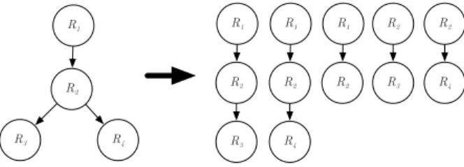
Congestion propagations are described by a directed graph of the road segments involved in the propagation that form a directed tree. It uses a new approach to search for congestion propagations, which examines the congestion trees backwards in time, so that the complexity of the procedure is only O(T N2), whereT is the length of the examined period in time intervals andNis the number of traffic jam phenomena during period T. It then filters out frequent congestion propagation trees from the collected propagation trees using the Apriori algorithm [40]. A congestion propagation tree counts as fre- quent if its occurrence is above anthreshold in the studied time interval, so its frequency is greater than a predefined threshold value. Within a frequent congestion propagation tree, a propagation path is a directed path that connects the root of the tree to any leaf.
Although STC is significantly faster than the STO method, theO(T N2)complexity remains too high for modeling a city with an extensive road network. The other problem is that the Apriori algorithm has exponential complexityO(2M), where M is the number of congestion propagation found.
The Spatio-Temporal Congestion Subgraph (STCS) [41]
method is a further development of the STC in which the FP- Growth algorithm [42] is used instead of the Apriori algorithm.
Because the complexity of the FP-Growth algorithm is lower than that of the Apriori algorithm, its use made the search for frequent congestion propagation trees quicker, but STCS uses STC found propagation trees, which hasO(T N2)complexity.
After reviewing the literature, it can be seen that the problem is actively studied by many researchers and they have presented several methods to solve the problem of finding frequent congestion propagation trees.
The problem with these solutions is that either the models of the road network are overly simplified (for example, with a square grid), or the method’s complexity is so high that in a real environment it is not able to search effectively or find every propagation in a sprawling city. They can not be used this way in real time, but even if the speed of the algorithms is not critical, they still require a lot of processing, which can be costly.
In the following chapters we introduce our newly developed method that solves the search for traffic jam propagation trees, in a way that:
1) describes the road network as a directed graph in the greatest detail possible,
2) while the algorithmic complexity is only linear, and therefore surpasses the existing solutions.
MARCH 2021 • VOLUME XIII • NUMBER 1 48
INFOCOMMUNICATIONS JOURNAL
INFOCOMMUNICATIONS JOURNAL 4
Fig. 1: Example for modeling a common intersection.
III. FLOW-SPEED RATIO-BASED CONGESTION DEFINITION
In Section II-A we have seen that there is currently no uniform traffic jam definition that does not use manually preset values. In this section, before introducing the Spatial Con- gestion Propagation Patterns (SCPP) algorithm, we thought it necessary to introduce a new traffic jam definition that does not require manual setting of thresholds or ratios, but does so automatically. Using our definition, it is easier and more reliable to generate input data for the Spatial Congestion Propagation Patterns (SCPP) algorithm.
In a real environment, the correct interpretation of a traffic jam always depends on the current road segment. Each road segment has a capacity value that determines how many vehicles can pass through that road segment per hour. The capacity is the theoretical upper limit of the number of vehicles that the measured hourly vehicle number never exceeds. If a higher load is imposed on a road segment it will mean that as the number of vehicles increases, their speed will begin to decrease. This will cause an increase in the ratio of traffic flow (volume) and speed until it finally reaches a critical value above which the traffic phenomenon can be considered a traffic jam. The critical flow-speed rate can be determined by the ratio of the capacity and the upper speed limit of the road segment.
Let N(I,R) be a directed graph representing a city’s road network, where I = {I1, I2, . . . , I|I|} is the set of intersections and R = {R1, R2, . . . , R|R|} the set of road segments. Since the road network model uses directed edges, the bidirectional road segments will be represented with two directed edges. It is not uncommon to see that vehicles can turn only in specific directions in complex intersections.
To model these intersections, additional intermediate nodes (intersections) have to be added. On Figure 1, we show an example for modeling a common intersection. The blue dots denote the intersections as the nodes of the graph, while the orange arrows are the directed edges. The red dots depict the intermediate nodes. These intermediate nodes help to model the allowed turning directions properly.
Using the recommendation of the Highway Capacity Man- ual 2016 (HCM2016) [43] and considering the current speed limit, the theoretical capacity of a segment of Rr (Free-way (FW)) road is described in Equation 1, whereSRr,limitis the maximum allowed speed in mph for road segmentRr, while the Lanes is the number of lanes on the road segmentRr. This equation is only valid for freeways, whereas equations for multi-lane highways, signalized highways and other road types can be found in HCM2016 [43]. It is worth mentioning
that the spread of autonomous vehicle will change the capacity formula in the future because the throughput of road segments will be increased due to better resource utilization [44], [45], [46].
LetFRr ={F1, F2, . . . , FT} be the time series of vehicle numbers (volume), whereRr is the edge of the road network graphN(I,R), where the data was measured,T is the length of the time series, andFt∈R+(t= 1,2, . . . , T). The vehicle speed time series is given bySRr={S1, S2, . . . , ST},where Rr is the edge of the road network graph N(I,R), where the data was measured,T is the length of the time series, and St∈R+(t= 1,2, . . . , T).
Using time series FRr and SRr the road segment’s FSRRr = {F SR1, F SR2, . . . , F SRT} flow-speed rate time series can also be calculated. The instantaneous rate F SRt of a road segment Rr can be determined using the following formula:
F SRt= Ft St
t= 1,2, . . . , T F SRt∈R+. (2) The critical flow-speed rate value for the road segmentRr:
F SRRr,critical= CP(SRr,limit) SRr,limit
, (3)
whereCP(SRr,limit)is the capacity of the road segment and SRr,limit is the speed limit of the road segment in mph.
Critical flow-speed rate F SRRr,critical is a predetermined constant value that does not vary with time.
Using the instantaneous and critical flow-speed rate, the current level of the traffic jamCRr ={C1, C2, . . . , CT} can be determined, where
Ct= F SRt
F SRRr,critical t= 1,2, . . . , T Dt∈R+. (4) Definition 1. At time ta traffic jam will occur on the road segmentRr of the road networkN(I,R), ifCt≥1(Ct ∈ CRr) soF SRt≥F SRRr,critical.
Figure 2 shows an example of a flow-speed rate-based congestion definition. Data shown in the figure were obtained from the Caltrans Performance Measurement System (PEMS) [47]. The first and second rows of the figure show vehicle number and speed data. The third row contains the momentary congestion levels. The dashed red line is the critical flow-speed rate of congestion. Times above the line can be considered a traffic jam. It is worth noting that in all periods where the speed has declined significantly, the congestion level is above the critical value.
Traffic congestion propagation identification method in smart cities