Three-dimensional Scene Understanding in Mobile Laser Scanning data
A thesis submitted for the degree of Doctor of Philosophy
Balázs Nagy
Scientific adviser:
Csaba Benedek, Ph.D
Faculty of Information Technology and Bionics Pázmány Péter Catholic University
Budapest, 2020
Acknowledgements
First of all I would like to express my sincere gratitude to my supervi- sor Csaba Benedek for his continuous support during my Ph.D study and work, for his motivation and patience. He is leading the way for me since my BSc studies and not just as a supervisor but a friend.
I have been a member of the Machine Perception Research Labora- tory (MPLAB) at SZTAKI since my BSc studies, so I would like to special thank to Prof. Tamás Szirányi head of MPLAB for providing remarks and advice regarding to my research and always supporting my work.
Pázmány Péter Catholic University (PPCU) is also gratefully ac- knowledged, thanks to Prof. Péter Szolgay who provided me the opportunity to study here.
I thank the reviewers of my thesis, for their work and valuable com- ments.
I thank my closest colleagues from the SZTAKI Machine Percep- tion Research Laboratory for their advice: Csaba Benedek, Andrea Manno-Kovács, Levente Kovács, László Tizedes, András Majdik and Attila Börcs. Special thanks to Levente Kovács and László Tizedes, who supported me their valuable advice and joint work.
Special thanks to Kálmán Tornai who coordinated and supported me during practice leading at PPCU.
Thanks to all the colleagues at PPCU and SZTAKI.
For further financial supports, thanks to the National Research, De- velopment and Innovation Fund, under grant number K-120233, KH- 125681 and KH-126688, the European Union and the Hungarian Gov- ernment from the project ’Thematic Fundamental Research Collabo- rations Grounding Innovation in Informatics and Infocommunications’
under grant number EFOP-3.6.2-16-2017-00013 and 3.6.3 VEKOP-16- 2017-00002 and the ÚNKP-19-3 New National Excellence Program of the Ministry of Human Capacities and the ÚNKP-20-4 new national excellence program of the ministry for Innovation and Technology from the source of the national research, development and innovation fund.
Last but not the least, I would like to thank my family: my parents and to my brother for supporting me spiritually throughout my Ph.D years and my life in general.
Abstract
Three novel approaches are proposed in this thesis connected to 3D point cloud processing, namely semantic scene segmentation, point cloud registration, and camera-Lidar extrinsic parameter calibration.
The proposed results are based on the combination of 3D geometry processing and deep learning based algorithms. The proposed meth- ods have been evaluated in large point cloud databases containing various complex urban traffic scenarios and we have compared the proposed approaches to state-of-the-art methods and the results show significant improvements against the existing novel approaches.
Contents
1 Introduction 1
1.1 Brief summary of point cloud segmentation datasets . . . 6
1.2 Outline of the thesis . . . 6
2 Deep learning based semantic labeling of mobile laser scanning data 9 2.1 Introduction . . . 10
2.1.1 Problem statement . . . 10
2.1.2 Sensors discussed in this chapter . . . 11
2.1.3 Aim of the chapter . . . 11
2.2 Related work . . . 12
2.3 Benchmark issues . . . 15
2.3.1 Data characteristic of MLS benchmarks . . . 17
2.4 Proposed approach . . . 18
2.4.1 Data model for training and recognition . . . 19
2.4.2 3D CNN architecture and its utilization . . . 21
2.5 Experimental Results and Evaluation . . . 22
2.5.1 Point cloud annotation and training . . . 22
2.5.2 Hyperparameter tuning . . . 23
2.5.3 Evaluation and comparison to reference techniques . . . . 25
2.5.4 Failure case analysis of the proposed C2CNN method and the PointNet++and SPLATNet3D references . . . 30
2.5.5 Implementation details and running time . . . 32
2.6 Conclusion of the chapter . . . 32
i
3 Robust registration between different type of point clouds and automatic localization approach for autonomous vehicles 33
3.1 Introduction . . . 34
3.1.1 Problem statement . . . 34
3.1.2 Sensors discussed in this chapter . . . 35
3.1.3 Aim of the chapter . . . 36
3.2 Related work . . . 36
3.3 Proposed approach . . . 37
3.3.1 Creating the reference High Definition map . . . 38
3.3.2 Real time object detection in the RMB Lidar point clouds 39 3.3.2.1 Ground removal . . . 40
3.3.2.2 Abstract field object extraction . . . 41
3.3.3 Object based alignment . . . 42
3.3.3.1 Keypoint selection . . . 43
3.3.3.2 Compatibility constrains between observed and landmark objects . . . 44
3.3.3.3 Optimal transform estimation . . . 45
3.4 Experiments and evaluation . . . 47
3.4.1 Case Study on Vehicle Localization Based on the Semanti- cally Labeled MLS Point Cloud . . . 47
3.4.2 Case study of IMU-free SLAM based on RMB Lidar data . 52 3.5 Conclusion of the chapter . . . 53
4 On-the-fly, automatic camera and Lidar extrinsic parameter cal- ibration 55 4.1 Introduction . . . 56
4.1.1 Problem statement . . . 56
4.1.2 Sensors discussed in this chapter . . . 56
4.1.3 Aim of the chapter . . . 57
4.2 Related work . . . 58
4.3 Proposed approach . . . 60
4.3.1 Structure from Motion (SfM) . . . 63
4.3.2 Point cloud registration . . . 66
CONTENTS iii
4.3.2.1 Object detection . . . 67
4.3.2.2 Object based alignment . . . 71
4.3.3 Control curve based refinement . . . 75
4.3.4 3D point projection calculation . . . 77
4.4 Experiments and Results . . . 79
4.4.1 Quantitative evaluation and comparison . . . 80
4.4.2 Robustness analysis of the proposed method . . . 82
4.4.3 Implementation details and running time . . . 85
4.5 Conclusion . . . 85
5 Conclusion 89 5.1 New Scientific Results . . . 89
5.2 Application of the Results . . . 94
5.3 Implementation details . . . 94
A Supplementary Material 95 A.1 Lidar technology and used sensors in this thesis . . . 95
A.1.1 Riegl VMX-450 . . . 95
A.1.2 Velodyne HDL64E . . . 96
A.2 Fundamentals of deep learning . . . 97
A.2.1 Convolution layer . . . 97
A.2.2 Pooling layer . . . 98
A.2.3 Fully Connected layers . . . 98
A.2.4 Dropout regularization . . . 98
A.2.5 Activation functions . . . 99
A.2.6 Loss function and training process . . . 99
B Summary of Abbreviations 103
References 121
List of Figures
1.1 Semantic labeling results of the proposed method [2] (Topic 1). . . 3 1.2 Projection results of the proposed target-less, automatic camera-
Lidar calibration method [1]. . . 5 2.1 MLS sensor and a scanned road segment. . . 11 2.2 Demonstration of the phantom effect in MLS data and the result
of phantom removal workflow with the proposed approach. . . 12 2.3 Point cloud characteristics comparison of measurements from the
same region obtained by a static Riegl VZ-400 TLS sensor and a moving Riegl VMX-450 MLS system, respectively. Point density is displayed as a function of the distance from the TLS sensor’s center position. . . 16 2.4 Data quality comparison between two reference datasets and the
proposed SZTAKI CityMLS dataset. . . 18 2.5 Different training volumes extracted from point cloud data. Each
training sample consists of K×K×K voxels (used K = 23), and they are labeled according to their central voxel (highlighted with red). . . 19 2.6 Voxelized training samples. The red voxels cover dense point cloud
segments, while green voxels contain fewer points. . . 21
v
2.7 Structure of the proposed 3D convolutional neural network, con- taining three 3D convolution layers, two max-pooling and two dropout layers. The input of the network is a K ×K ×K voxel (usedK = 23) data cube with two channels, featuring density and point altitude information. The output of the network is an integer value from the set L = 0..8. . . 22 2.8 Qualitative comparison of the results provided by the three ref-
erence methods, (c) OG-CNN, (d) Multi-view approach and (e) PointNet++, and the proposed (f) C2CNN approach in a sample scenario. For validation, Ground Truth labeling is also displayed in (b). . . 25 2.9 Test result on the TerraMobilita data. . . 28 2.10 Test result on the Oakland data. . . 29 2.11 Qualitative segmentation results of the proposed C2CNN method. 30 2.12 Typical failure cases of the proposed and the reference methods. . 31 3.1 Point cloud scenes captured at a downtown area using a Velodyne
HDL64E Rotating Multi-Beam (RMB) Lidar sensor and a Riegl VMX450 Mobile Laser Scanning (MLS) system. Class color codes in the segmented cloud; black: facade, dark gray: ground, mid gray: tall column, bright gray: street furniture, green: tree crowns 35 3.2 The workflow of the proposed point cloud alignment algorithm. . 38 3.3 Result of ground removal in RMB Lidar point cloud. . . 40 3.4 Extracted objects used for the alignment calculation. Color codes
are the following (a) different landmark objects of the HD map are displayed with different color (b) red: ground/road, other colors:
different detected objects in the RMB Lidar frame. . . 41 3.5 Choosing key points for registration. . . 43 3.6 Illustration of the output of the proposed object matching algo-
rithm based on thefingerprint minutiae approach [40]. Red points mark the objects observed in the RMB Lidar frame. . . 46
LIST OF FIGURES vii
3.7 Results of the proposed registration approach with 8 keypoint se- lection strategy. RMB Lidar point clouds are displayed with red, while the MLS data is shown with multiple colors depending on the segmentation class. First two rows correspond to the same scene, just ground and facades are not displayed in the 2nd row for better visualization of the object based alignment. . . 48 3.8 Evaluation of the proposed approach with various keypoint selec-
tion strategies and comparison to [12] . . . 49 3.9 Application of the proposed C2CNN classification approach for
point cloud registration enhancement. Automatic registration re- sults of a sparse RMB Lidar point cloud (shown with red in all images), to the dense MLS measurements (remaining colors). Fig- ure (c) shows the registration results on the raw point cloud with notable inaccuracies (different class colors in MLS only serve bet- ter visibility). Figure (d) demonstrates the output of successful registration based on removing the dynamic objects from the MLS point cloud using the proposed C2CNN method. . . 51 3.10 SLAM results with Velodyne HDL64 in Kosztolányi tér, Budapest
(1.2M points from80frames captured at3fps from a moving vehicle). 52 4.1 Workflow of the proposed approach. . . 62 4.2 SfM point cloud generation (a) 4 from a set of 8 images to process.
(b) Generated sparse point cloud (2041 points). (c) Densified point cloud (257796 points). . . 63 4.3 (a) Mask R-CNN [27] based instance level semantic segmentation.
(b) Marking dynamic objects in the 3D SfM point clouds based on the 2D semantic segmentation (red: vehicle, blue: pedestrian) . . 65 4.4 (a) Sparse cloud with each point assigned a unique color. (b) One
frame showing color coded 2D points that contribute to the 3D point with the same color in (a) - also showing example correspon- dences. (c) Re-projection error . . . 66
4.5 (a) Voxel representation of the proposed SVS. (b) Pillars repre- sentation of the proposed SVS. (c) Linearity and flatness features computed based on eigen value analysis. Blue: flat voxels, red:
high linearity, green: scattered region. (d) Extracted objects from the point cloud using pillar representation. (e) Extracted objects from the point cloud using voxel representation. . . 69 4.6 Demonstration of the object-based coarse alignment step (a) Mask
R-CNN [27] based dynamic object filtering. (b) Point pillars [25]
based dynamic object filtering. (c) Initial translation between the synthesized (dark grey) and the Lidar (orange) point cloud. (d) Object based coarse alignment without dynamic object removal (e) Proposed object based alignment after removing dynamic objects.
Identically colored ellipses mark the corresponding objects. . . 72 4.7 Landmark correspondences between the detected objects in the
SfM and Lidar point clouds. Assignment estimation is constrained by the computed Linearity and Flatness values. Red color rep- resents linear voxels, blue color denotes flat structures and green marks noisy unstructured regions. . . 75 4.8 Demonstration of the control curve based registration refinement
step. Image (a): output of rigid body transform based registration (TR) with local registration artifacts; Image (b) corrections via registration refinement (T?) . . . 76 4.9 Demonstration of the curve based refinement step. . . 77 4.10 Workflow of the projection calculation process. . . 78 4.11 Qualitative point cloud projection results onto the image domain
based on the proposed fully automatic, target-less camera-Lidar calibration approach. Blue color denotes the projected 3D points which belong to the object candidates detected during the course alignment process. . . 79 4.12 Robustness analysis of the proposed method. It shows the differ-
ences measured in pixels in the x and y directions over the subse- quent calibration trials. . . 84
LIST OF FIGURES ix
4.13 Demonstration of intermediate steps of the proposed method in a selected scene. Results of the (a)(b) dynamic object filtering and (c)(d) 3D abstract object extraction steps, which are used as input of the proposed object based alignment technique (Sec. 4.3.2.2). 86 4.14 Qualitative results of the proposed registration and projection steps. 87 A.1 MLS technology used in this thesis. . . 96 A.2 Most commonly used activation functions. . . 99
List of Tables
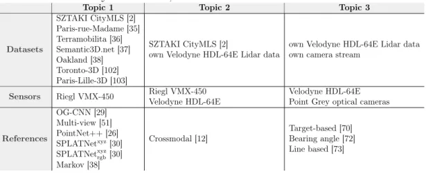
1.1 Summary of datasets, sensors and references connected to the thesis. 7 1.2 Dataset comparison of dense semantic point cloud segmentation. . 7 2.1 Performance analysis of the proposed C2CNN method as a function
of the voxel size parameter. . . 24 2.2 Performance analysis of the proposed C2CNN method as a function
of the data cube size K×K×K . . . 24 2.3 Quantitative evaluation of the proposed C2CNN approach and the
reference techniques on the new SZTAKI CityMLS dataset. . . 26 2.4 Quantitative comparison of the proposed method and the reference
ones on the Oakland dataset. F-rate values are provided in percent. 29 3.1 Quantitative evaluation of the proposed point cloud registration
technique based on the raw MLS point cloud, the semantically labeled point cloud using the proposed C2CNN approach, and the manually labeled data, respectively. . . 50 4.1 Performance comparison of the target-less proposed method with
two state-of-the-art target-less reference methods and with a target- based (supervised) reference technique. Notes: *Test set names Slow and Fast refer to the speed of the data acquisition platform. 81
xi
4.2 Performance evaluation of the proposed method at different cali- bration steps. First we measure the projection error using only the object based coarse alignment, then we extended the method with the dynamic object filtering based on Mask R-CNN and PointPil- lars techniques, and finally we measure the impact of the ICP and the proposed curve based refinement. . . 82
Chapter 1 Introduction
In recent decades, huge progress has been made in the field of sensors for environ- ment perception and mapping, which greatly influences the remarkable scientific progress in the field of object detection and classification [4, 15, 23, 24, 25, 26], scene segmentation and understanding [2, 26, 27, 28, 29, 30]. Several results have been adapted in real-world applications such as driving assistance systems and mobile robot perception and navigation, however, each application has unique re- quirements regarding to safety level, quality, and processing time, furthermore they rely on different sensors which make challenging the general usability of the scientific results. Nowadays, state-of-the-art autonomous systems such as self-driving vehicles, unmanned aerial and ground vehicles (UAV, UGV) and hu- manoid robots rely on a wide range of sensors. Optical cameras are able to capture high resolution, feature-rich data, time-of-flight sensors scan mostly interior areas in 3D, radars measure positions and velocities and Lidars are used for accurate 3D environment mapping. To utilize the advantages of each sensor the focus of scientific and industrial progress has been shifted towards robust sensor fusion.
Though the breakthrough of deep learning methods such as [25, 26, 27, 31]
significantly improved the accuracy and generality of computer vision and scene understanding applications, we are still far from human-level performance. To train these models, a huge amount of precisely labeled data is required, further- more in challenging situations such asheavy traffic scenarios in dense urban areas, complex unknown regions like off-road scenes, and bad weather and illumination conditions they still often underperform. Considering various sensor data can
1
improve the accuracy of the perception and relying on multiple sensors can lead to more robust algorithms which are less influenced by environmental effects such asheavy rain and illumination changes.
Using detailed background information such as High Definition (HD) maps and Geographic Information Systems (GIS) [32, 33] to achieve accurate scene understanding and reliable localization is also an important research direction.
Data fusion between on-board sensor data and detailed maps stored in offline databases is used in several industrial projects such as Waymo and Uber self- driving vehicles [34]. By the wide-spread emergence of smart cities with detailed map information, autonomous vehicles can utilize the static background informa- tion for navigation, localization, and contextual based scene analysis by register- ing their real-time captured on-board sensors data to the corresponding part of the detailed map.
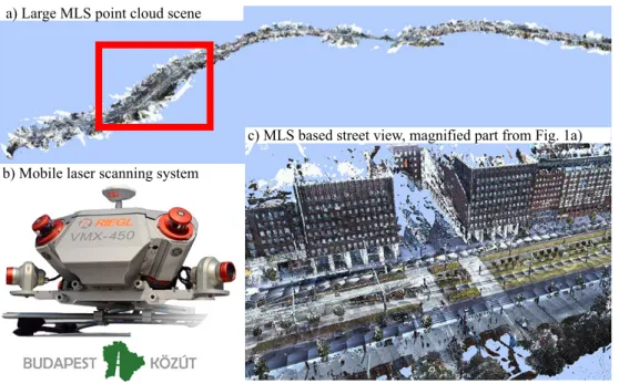
Lidar technology has improved significantly in terms of resolution, scanning speed, and accuracy, furthermore the size and the cost of Lidar sensors have been decreasing steadily. Contrary to optical cameras, Lidars are not affected by the lighting conditions and illumination changes, they can operate more ro- bustly under various weather conditions and they are able to obtain accurate, real 3D geometric information from the scene, so they are becoming one of the main cutting-edge technology in environment perception. Lidar sensors emit laser beams to capture the 3D geometric information of the scene and measure the echo time of the reflected beams from arbitrary object surfaces. Knowing the speed of light propagation (c) and the measured echo time (t) of the emitted beam the sensor is able to calculate the distance (s) of the given target: s= (c×t)/2. In general, we can group laser scanning into three main categories: hydro-graphic, aerial and terrestrial laser scanning. Hydro-graphic Lidars are able to measure the depth of the seabed and they provide an accurate surface model while air- borne Lidars are able to scan large areas for applications such as urban planning andvegetation survey. Terrestrial laser scanning (TLS) can be divided into offline and real-time data acquisition. Terrestrial mapping systems such as Riegl VMX- 450 and FARO Focus are used in various applications such asroad management and traffic control, city mapping, and cultural heritage conservation. They are able to obtain very dense, feature-rich 3D data with precisely registered color
3
information due to integrated cameras. While real-time sensors such as Velodyne Lidars are designed to navigate autonomous vehicles, so they provide relatively sparse, but also very accurate 3D measurements with a high-frequency update.
This thesis covers three different challenging research problems containing new scientific results related to point cloud segmentation, Lidar-based localization of self-driving vehicles, and camera-Lidar calibration. For data acquisition, two different types of Lidar scanner and a camera platform were used. In the following, I give a brief description of the investigated research problems which will be explained in more detail in the following chapters of the thesis. Table 1.1 gives a brief outline about the used datasets, sensors and references connected to the proposed topics.
• Topic 1 - Deep learning based semantic labeling of mobile laser scanning data focusing on motion artifacts:
Figure 1.1: Semantic labeling results of the proposed method [2] (Topic 1).
Mobile mapping systems (MMS) are able to obtain very accurate and dense 3D point clouds from large areas for applications such asurban planning and road management. Though several point cloud segmentation models [26, 27,
28, 29, 30] can be found in the literature, the high variety of existing laser scanners (obtaining point cloud data with very different characteristics) requires to adapt the models to the given dataset for accurate semantic labeling. In this thesis, the input data was provided by a Riegl VMX-450 mobile mapping system, which contains twoRiegl VQ-450 laser scanners, a well design calibrated camera system, and an IMU/GNSS unit. The scanner registers the obtained frames into a global coordinate system and for each 3D points, it assigns RGB color values based on the calibrated cameras.
In the proposed approach for semantic labeling of dense point clouds, we have considered the characteristic of the data and we have proposed a two-channel 3D convolutional neural network (CNN) which is able to ef- ficiently label the scene into different categories focusing on challenging scenarios such as elongated noise regions, artifacts (defined as Phantom ob- jects) caused by the concurrent movement of the dynamic objects with the scanning platform such asvehicles andpedestrians. We have also tested our proposed method on publicly available datasets [35, 36, 37, 38] to show the robustness of the method and we have compared the model against different state-of-the-art methods.
• Topic 2 - Robust, real-time registration between different type of point clouds and automatic localization approach for autonomous vehicles:
3D point cloud registration is a well-studied computer vision problem, so several solutions exist in the literature. Though some state-of-the-art meth- ods are able to achieve very high accuracy, they usually assume that the characteristics of the source and target point cloud are the same or very similar, and in most cases, they rely on some iterative methods such as Iterative Closest Point ICP [39] which requires a suitable initial starting point for the registration process. We have proposed an object-based coarse alignment method for point cloud registration which can be refined with a point level registration step. Our method is able to robustly register point clouds with very different characteristics and it is able to handle large initial miss-alignment.
5
Figure 1.2: Projection results of the proposed target-less, automatic camera-Lidar calibration method [1].
GPS based localization accuracy mostly in dense urban environment fluc- tuates between a wide range which makes it unreliable and according to our experiments in the streets of Budapest, Hungary, GPS position error can be larger than 10 meters. We have extended our point cloud regis- tration method with a robust key-point extraction algorithm and we have proposed a localization approach that is able to precisely register a real- time captured Lidar point cloud obtained by an autonomous vehicle to a static dense background map.
• Topic 3 - On-the-fly, automatic camera and Lidar extrinsic pa- rameter calibration:
The main goal of the proposed method is to automatically calibrate a cam- era and a Lidar sensor relative to each other mounted onto the top of a moving vehicle. The proposed method works in an end-to-end manner without assuming any user interaction and it does not require any specific calibration objects such as 3D boxes and chessboard patterns. The main advantage of the method is to be able to periodically recalibrate the sen- sors on-the-fly i.e. without stopping the vehicle. We have re-defined the camera-Lidar calibration problem as a 3D point cloud registration task by generating 3D point clouds from the incoming consecutive camera frames
using a Structure from Motion (SfM) method. We have proposed a two- stage registration method which is able to accurately register the point clouds. First, we transform the Lidar point cloud to the coordinate system of the generated SfM point cloud using an object-based alignment, and fi- nally, we have proposed a control curve-based refinement method to handle the deformation problem of point clouds occurring during the SfM process- ing method. As a result of the registration, we are able to determine an accurate extrinsic parameter calibration (see Fig. 1) between the camera and the Lidar sensors.
1.1 Brief summary of point cloud segmentation datasets
Static point cloud datasets for 3D semantic segmentation is introduced in Chapter 2 related to Topic 1. Table 1.2 gives a short description of the main parameters of the databases and in Chapter 2 we analyze the datasets in more detail. This thesis focus on static point cloud segmentation, however we note that several dataset for semantic segmentation of sequential Lidar point cloud data can be found in the literature. In case of segmentation of dense static point cloud data, approaches have to process huge databases with millions of points contrary segmentation of sparse sequential point cloud data where the focus is on real-time data processing.
1.2 Outline of the thesis
In the following, we present the outline of the thesis. In Chapter 2 we propose a novel deep learning based approach for semantic labeling of dense point clouds collected in urban environment into different classes such as ground, facade, veg- etation, pedestrians, parking vehicles, moving dynamic objects called Phantoms here, etc. We propose a 3D convolutional neural network approach to predict the class of the given samples trained in an end-to-end manner.
Chapter 3 introduces a novel object-level registration method based on a fin- gerprint minutiae matching [40] algorithm which is able to accurately align point clouds obtained by different laser scanners to a common coordinate system. A
1.2 Outline of the thesis 7
Table 1.1: Summary of datasets, sensors and references connected to the thesis.
Topic 1 Topic 2 Topic 3
Datasets
SZTAKI CityMLS [2]
Paris-rue-Madame [35]
Terramobilita [36]
Semantic3D.net [37]
Oakland [38]
Toronto-3D [102]
Paris-Lille-3D [103]
SZTAKI CityMLS [2]
own Velodyne HDL-64E Lidar data
own Velodyne HDL-64E Lidar data own camera stream
Sensors Riegl VMX-450 Riegl VMX-450 Velodyne HDL-64E
Velodyne HDL-64E Point Grey optical cameras
References
OG-CNN [29]
Multi-view [51]
PointNet++[26]
SPLATNetxyz[30]
SPLATNetxyzrgb[30]
Markov [38]
Crossmodal [12]
Target-based [70]
Bearing angle [72]
Line based [73]
Table 1.2: Dataset comparison of dense semantic point cloud segmentation.
Dataset Annotation Classes #points Fields Sensor Year Organization
Oakland3D 5 1.6M x, y, z,
label SICK LMS (MLS) 2009 Carnegie Mellon University
Paris-rue-Madame 17 20M x, y, z,
intensity, label LARA2-3D (MLS) 2014 MINES ParisTech
TerraMobilita 15 12M x, y, z,
intensity, label Riegl LMS-Q120i (MLS) 2015 University of Paris-Est
Paris-lille-3D 50 143M x, y, z,
intensity, label Velodyne HDL-32E (MLS) 2018 MINES ParisTech
Toronto3D 8 78.3M x, y, z, r, g, b,
intensity, label Teledyne Optech Maverick (MLS) 2020 University of Waterloo
Semantic3D 8 4009M x, y, z, r, g, b,
intensity, label unknown (TLS) 2017 ETH Zurich
SztakiCityMLS
point-wise
9 327M x, y, z, r, g, b,
label Riegl VMX-450 (MLS) 2019 SZTAKI
novel localization approach is also proposed in Chapter 3 which is able to ro- bustly determine the position and the orientation of an autonomous vehicle by registering its on-board Lidar data to a dense point cloud.
We present a novel, on-the-fly camera-Lidar extrinsic parameter calibration in Chapter 4. The proposed method works automatically without any user inter- actions and it does not require any target objects it relies on only the captured camera images and the obtained Lidar point cloud.
At the end of the thesis, a summary and conclusion can be found. Appendix A gives a brief insight into the mathematical and technical details of the used algorithms and concepts, while Appendix B summarizes the used abbreviations.
Chapter 2
Deep learning based semantic labeling of mobile laser scanning data
This chapter introduces a novel 3D convolutional neural network (CNN) based method to segment point clouds obtained by mobile laser scanning (MLS) sensors into nine different semantic classes, which can be used for high definition city map generation. The main purpose of semantic point labeling is to provide a detailed and reliable background map for self-driving vehicles (SDV), which indicates the roads and various landmark objects for navigation and decision support of SDVs.
The proposed approach considers several practical aspects of raw MLS sensor data processing, including the presence of diverse urban objects, varying point density, and strong measurement noise of phantom effects cased by objects mov- ing concurrently with the scanning platform. A new manually annotated MLS benchmark set called SZTAKI CityMLSis also introduced in this chapter, which is used to evaluate the proposed approach, and to compare our solution to various reference techniques proposed for semantic point cloud segmentation.
9
2.1 Introduction
Self-localization and scene understanding are key issues for self-driving vehicles (SDVs), especially in dense urban environments. Although the GPS-based posi- tion information is usually suitable for helping human drivers, its accuracy is not sufficient for navigating a SDV. Instead, the accurate position and orientation of the SDV should be calculated by registering the measurements of its on-board visual or range sensors to available 3D city maps [10].
Mobile laser scanning (MLS) platforms equipped with time synchronized Lidar sensors and navigation units can rapidly provide very dense and feature rich point clouds from large environments (see Fig. 2.1), where the 3D spatial measurements are accurately registered to a geo-referenced global coordinate system [41, 42, 43]. In the near future, these point clouds may act as a basis for detailed and up-to-date 3D High Definition (HD) maps of the cities, which can be utilized by self driving vehicles for navigation, or by city authorities for road network management and surveillance, architecture or urban planning. However, all of these applications require semantic labeling of the data (Fig. 1). While the high speed of point cloud acquisition is a clear advantage of MLS, due to the huge data size yielded by each daily mission, applying efficient automated data filtering and interpretation algorithms in the processing side is crucially needed, which steps still introduce a number of key challenges.
2.1.1 Problem statement
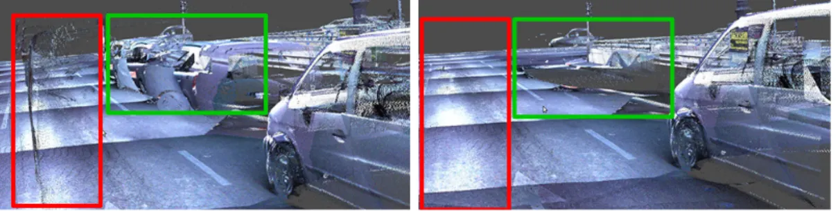
Taking the raw MLS measurements, one of the critical issues is thephantom effect caused by independent object motions (Fig. 2.1.1). Due to the sequential nature of the environment scanning process, scene objects moving concurrently with the MLS platform (such as passing vehicles and walking pedestrians) appear as phantom-like long-drawn, distorted structures in the resulting point clouds [11].
It is also necessary to recognize and mark all transient scene elements such as pedestrians, parking vehicles [42] or trams from the MLS scene. On one hand, they are not part of the reference background model, thus these regions must be eliminated from the HD maps. On the other hand, the presence of these objects may indicate locations of sidewalks, parking places etc. Column-shaped
2.1 Introduction 11
Figure 2.1: MLS sensor and a scanned road segment.
objects, such as poles, traffic sign bars [41], tree trunks are usually good landmark points for navigation. Finally, vegetation areas (bushes, tree foliage) should also be specifically labeled [43]: since they are dynamically changing over the whole year, object level change detection algorithms should not take them into account.
2.1.2 Sensors discussed in this chapter
In this chapter, we utilize the measurements of the Riegl VMX450 MLS system.
The Riegl VMX450 MLS system is highly appropriate for city mapping, urban planning and road surveillance applications. It integrates two Riegl laser scan- ners, a well designed calibrated camera platform, and a high performance Global Navigation Satellite System (GNSS). It provides extremely dense, accurate (up to global accuracy of a few centimeters) and feature rich data with relatively uniform point distribution.
2.1.3 Aim of the chapter
To address the above complex multi-class semantic labeling problem we introduce a new 3D convolutional neural network (CNN) based approach to segment the
(a) Raw MLS data with phantoms. (b) Result of phantom removal workflow.
Figure 2.2: Demonstration of the phantom effect in MLS data and the result of phantom removal workflow with the proposed approach.
scene in voxel level, and for testing the approach, we present theSZTAKI CityMLS benchmark set containing different labeled scenes from dense urban environment.
Differently from previously proposed general point cloud labeling frameworks [23, 26], the present approach is focusing on challenging issues of MLS data processing in self-driving applications.
2.2 Related work
3D semantic segmentation is one of the most researched fields in point cloud based scene understanding. Many of the proposed segmentation methods deal with the segmentation of real-time obtained point cloud sequences for self-driving applications and real-time SLAM, others focus on the segmentation of dense point clouds acquired by mobile mapping systems for urban planning and infrastructure monitoring. During dense point cloud segmentation managing huge amount of data is challenging, furthermore several motion artifacts and noise occur in the obtained point clouds while in segmentation of real-time point cloud streams online data processing and the sparsity of the data are the main challenges [105].
In this thesis we focus on dense point cloud segmentation.
While a number of various approaches have already been proposed for general point cloud scene classification, they are not focusing on all practical challenges of the above introduced worklfow of 3D map generation from raw MLS data.
In particularly, only a few related works have discussed the problem of phantom
2.2 Related work 13
removing. Point-level and statistical feature based methods such as [44] and [45]
examine the local density of a point neighborhood, but as noted in [46] they do not take into account higher level structural information, limiting the detection rate of phantoms. The task is significantly facilitated if the scanning position (e.g. by tripod based scanning [47]) or a relative time stamp (e.g. using a rotating multi- beam Lidar [48]) can be assigned to the individual points or point cloud frames, which enables the exploitation of multi-temporal feature comparison. However, in case of our examined MLS point clouds no such information is available, and all points are represented in the same global coordinate system.
Several techniques extract various object blob candidates by geometric scene segmentation [41, 4], then the blobs are classified using shape descriptors, or deep neural networks [4]. Although this process can be notably fast, the main bottleneck of the approach is that it largely depends on the quality of the object detection step.
Alternative methods implement a voxel level segmentation of the scene, where a regular 3D voxel grid is fit to the point cloud, and the voxels are classified into various semantic categories such as roads, vehicles, pole-like objects, etc. [43, 24, 29]. Here a critical issue is feature selection for classification, which has a wide bibliography. Handcrafted features are efficiently applied by a maximum-margin learning approach for indoor object recognition in [49]. Covariance, point density and structural appearance information is adopted in [50] by a random forest classifier to segment MLS data with varying density. However, as the number and complexity of the recognizable classes increase, finding the best feature set by hand induces challenges.
3D CNN based techniques have been widely used for point cloud scene clas- sification in the recent years, following either global or local (window based) ap- proaches. Global approaches consider information from the complete 3D scene for classification of the individual voxels, thus the main challenge is to keep the time and memory requirements tractable in large scenes. The OctNet method imple- ments a new complex data structure for efficient 3D scene representation which enables the utilization of deep and high resolution 3D convolutional networks [23]. From a practical point of view, by OctNet’s training data annotation opera-
tors should fully label complete point cloud scenes, which might be an expensive process.
Sliding window based techniques are usually computationally cheaper, as they move a 3D box over the scene, using locally available information for the clas- sification of each point cloud segment. The Vote3Deep [24] assumes a fixed-size object bounding box for each class to be recognized, which might be less efficient if the possible size range of certain objects is wide. A CNN based voxel classifica- tion method has recently been proposed in [29], which uses purely local features, coded in a 3D occupancy grid as the input of the network. Nevertheless, they did not demonstrate the performance in the presence of strong phantom effects, which require accurate local density modeling [45, 46].
[99] represents 3D objects as spherical projections around their barycenter and a neural network was trained to classify the spherical projections. Two com- plementary projections namely a depth variations projection of the 3D objects and a contour-information projection from different angles were introduced. A multi-view fusion network was introduced in [100] to learn to get a global feature descriptor by fusing the features from all. The model consists of three key parts:
the feature extraction structure to extract the features of point clouds, the view fusion network to merge features of 2.5D point clouds from all views into a global feature descriptor, and a classifier composed of fully connected layers to perform classifications. Another multi-view technique [51] projects the point cloud from several (twelve) different viewpoints to 2D planes, and trains 2D CNN models for the classification. Finally, the obtained labels are backprojected to the 3D point cloud. These approaches presents high quality results on synthetic datasets and in point clouds from factory environments, where due to careful scanning complete 3D point cloud models of the scene objects are available. Application to MLS data containing partially scanned objects is also possible, but the advantages over competing approaches are reduced here [51].
Methods such as VolMap [106], LiSeg [108] and PointSeg [109] focus on real- time point cloud segmentation reducing the 3D parameter space to a 2D surface.
VolMap [106] is a modified version of U-Net [110] taking a Bird-eye view image created from the 3D point cloud. Both LiSeg [108] and PointSeg [109] create a range view image from the point cloud and they use dilated convolution to
2.3 Benchmark issues 15
extract relevant features for training. While LiSeg proposes a fully convolution network approach to segment the range image PointSeg is based on SqueezeNet [107], which introduces squeezing re-weighting layers.
PointNet++ [26] introduces a hierarchical neural network for point set clas- sification. The method takes random samples within a given radius of the ex- amined point, so it does not exploits density features. Results are demonstrated on synthetic and indoor data samples, with dense and accurate spatial data and RGB color information. PointConv [101] is a convolution based extension of the PointNet++, which allow to dramatically scale up the network and significantly improve its performance.
The Similarity Group Proposal Network (SGPN) [28] uses PointNet++ as a backbone feature extractor, and presents performance improvement by adding several extra layers to the top of the network structure. However as noted by the authors, SGPN cannot process large scenes on the order 105 or more points [28], due to using a similarity matrix whose size scales quadratically as the number of points increases. This property is disadvantageous for MLS data processing, where a typical scene may contain over 107 points.
The Sparse Lattice Network (SPLATNet3D) [30] is a recent technique which able to deal with large point cloud scenes efficiently by using a Bilateral Con- volution Layer (BCL). SPLATNet3D [30] projects the extracted features to a lattice structure, and it applies sparse convolution operations. Similarly to voxel based approaches, the lattice structure implements a discrete scene representa- tion, where one should address under- and over-segmentation problems depending on the lattice scales.
2.3 Benchmark issues
A number of benchmark sets have already been published for 3D point cloud segmentation in urban environment, including MLS datasets Oakland [38] (1.6M points), Paris-rue-Madame (20M points) [35] and data from the IQmulus & Ter- raMobilita Contest (12M labeled points) [36]. However, their available annotated segments are relatively small, which make the development of supervised classi- fication algorithms less relevant due to over fitting problems.
Figure 2.3: Point cloud characteristics comparison of measurements from the same region obtained by a static Riegl VZ-400 TLS sensor and a moving Riegl VMX-450 MLS system, respectively. Point density is displayed as a function of the distance from the TLS sensor’s center position.
The Semantic3D.net benchmark [37] contains a considerable larger set of la- beled data, however it has been created with static terrestrial laser scanners (TLS) which produce more accurate and in certain regions significantly denser point clouds than MLS. As shown in Fig. 2.3 the point density of a single TLS sensor is steeply decreasing as a function of the distance from the sensor, while applying mobile scanning, we can obtain a more uniform, but generally lower point density in the same region. In addition, the density characteristic of a large point cloud segment obtained by TLS from multiple scanning positions is strongly varying, since TLS operators may follow arbitrary trajectories and tim- ing constraints during the scanning mission. Therefore, comparing two different TLS datasets may show significant differences, even if they have been recorded by the same scanner, but for different purpose or by different operators. As a consequence, developing widely usable object detection methods for large-scale TLS datasets needs careful practical considerations.
2.3 Benchmark issues 17
On the other hand, MLS scene segmentation is today a highly relevant field of research, with strong industrial interest. In MLS data recording, the car passes with a normal 30-50 km traveling speed, following a more predictable trajectory (usually scans are preformed in both directions for a two-way road), therefore the effects of the driving dynamics on the obtained point cloud can be indirectly incorporated into the learning process. However, compared to TLS data, ghost filtering is more difficult, and the measurement noise is higher.
In this chapter, we utilize MLS data captured by a Riegl VMX-450 for real industrial usage by the Road Management Department of the Budapest City Council. Our new SZTAKI CityMLS dataset contains in total around 327 Million annotated points from various urban scenes, including main roads with both heavy and solid traffic, public squares, parks, and sidewalk regions, various types of cars, trams and buses, several pedestrians and diverse vegetation.
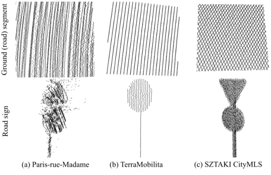
2.3.1 Data characteristic of MLS benchmarks
As shown in Fig. 2.4 the data characteristic of SZTAKI CityMLS is significantly different from TerraMobilita and Paris-rue-Madam data, making the proposal of the new benchmark indeed relevant. While Paris-rue-Madame database contains the most dense point clouds, due to registration issues of the recorded Rotating Multi-beam Lidar (Velodyne) frames, the obtained point cloud is quite noisy. On the other hand, the TerraMobilita database was captured with multiple 2D laser scanners yielding accurate spatial point cloud coordinates, but the measurements are sparse: depending on the speed of the scanning platform smaller objects may be composed of a few line segments only. As forSZTAKI CityMLS, the Riegl VMX- 450 scans are well suited to industrial applications requiring dense, accurate and notable homogeneous point clouds.
Figure 2.4: Data quality comparison between two reference datasets and the proposed SZTAKI CityMLS dataset.
2.4 Proposed approach
In this section, we propose a new 3D CNN based semantic point cloud segmenta- tion approach, which is adopted to dense MLS point clouds of large scale urban environments, assuming the presence of high variety of objects, with strong and diverse phantom effects. The present technique is based on our earlier model [11] specifically developed for phantom detection and removal, which we extend for recognizing nine different semantic classes required for 3D map generation:
phantom, tram/bus, pedestrian, car, vegetation, column, street furniture, ground and facade. As main methodological differences from [11], our present network uses a two channel data input derived from the raw MLS point cloud featuring local point density and elevation, and a voxel based space representation, which can handle the separation of tree crowns or other hanging structures from ground objects more efficiently than the pillar based model of [11]. To keep the com- putational requirements low, we implemented a sparse voxel structure avoiding unnecessary operations on empty space segments.
2.4 Proposed approach 19
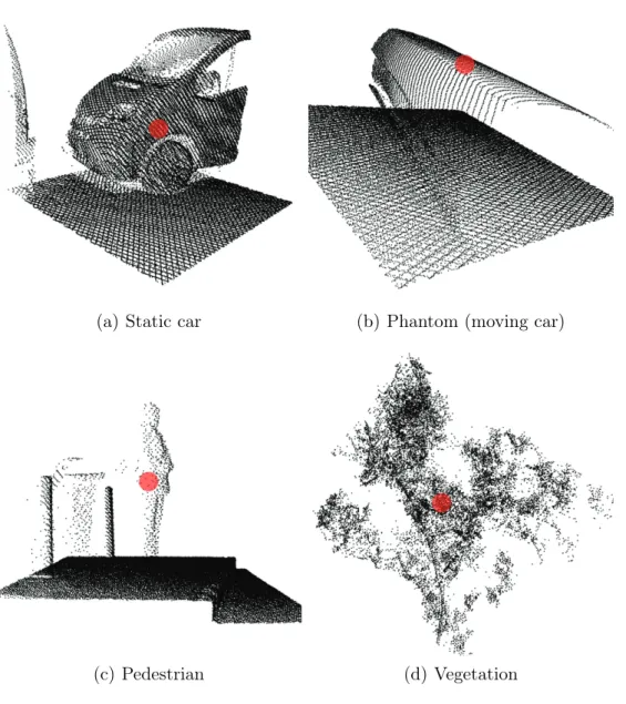
(a) Static car (b) Phantom (moving car)
(c) Pedestrian (d) Vegetation
Figure 2.5: Different training volumes extracted from point cloud data. Each training sample consists of K × K × K voxels (used K = 23), and they are labeled according to their central voxel (highlighted with red).
2.4.1 Data model for training and recognition
Data processing starts with building our sparse voxel structure for the input point cloud, with a fine resolution (used λ = 0.1m voxel side length). During classification we will assign to each voxel a unique class label from our nine-
element label set, based on majority votes of the points within the voxel.
Next we assign two feature channels to the voxels based on the input point cloud: pointdensity, taken as the number of included points, andmean elevation, calculated as the average of the point height values in the voxel.
The unit of training and recognition in our network is a K ×K ×K voxel neighborhood (used K = 23), called hereafter training volume. To classify each voxel v, we consider the point density and elevation features in all voxels in the v-centered training volume, thus a given voxel is labeled based on a 2-channel 3D array derived from K3 local voxels. The proposed 3D CNN model classifies the different training volumes independently. This fact specifies the roles of the two feature channels: while the density feature contributes to model the local point distribution within each semantic class, the elevation channel informs us about the expected (vertical) locations of the samples regarding the different categories, providing impression from the global position of the data segment within the large 3D scene. The elevation of a given sample is determined by subtracting the actual ground height elevation from the geo-referenced height of the sample.
Fig. 2.5 demonstrates various training volumes, used for labeling the central voxel highlighted with red color. As we consider relatively large voxel neighbor- hoods with K ·λ (here: 2.3m) side length, the training volumes often contain different segments of various types of objects: for example, Fig. 2.5(b) contains both phantom and ground regions, while Fig. 2.5(c) contains column, ground and pedestrian regions. These variations add supplementary contextual information to the training phase beyond the available density and elevation channels, making the trained models stronger.
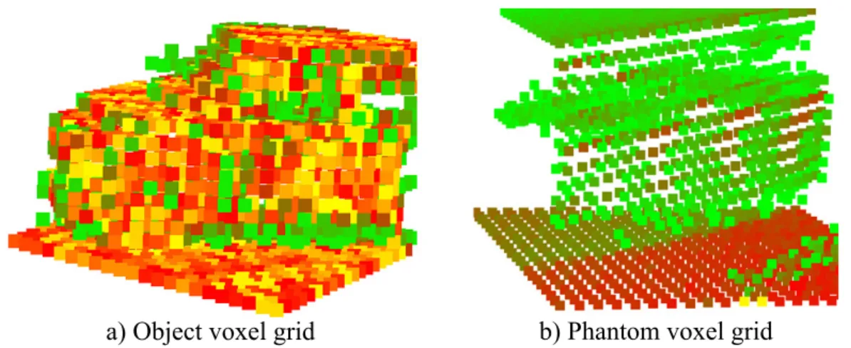
Fig. 2.6 represents the voxelized training samples. Based on our experiments phantom objects show more sparse data characteristic than other static back- ground objects. The ground region under the phantom objects (Fig. 2.6 (b)) is more dense than thephantom, furthermore it can be seen a parking vehicle (Fig.
2.6 (a)) which also shows more dense data characteristic.
2.4 Proposed approach 21
Figure 2.6: Voxelized training samples. The red voxels cover dense point cloud segments, while green voxels contain fewer points.
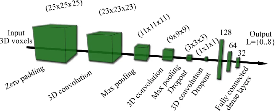
2.4.2 3D CNN architecture and its utilization
The proposed 3D CNN network implements an end-to-end pipeline: the feature extractor part (combination of several 3D convolution, max-pooling and dropout layers) optimizes the feature selection, while the second part (fully connected dense layers) learns the different class models. Since the size of the training data (23 × 23×23) and the number of classes (9) are quite small, we construct a network with a similar structure to the well known LeNet-5 [52], with adding an extra convolution layer and two new dropout layers to the LeNet-5 structure, and exchanging the 2D processing units to the corresponding 3D layers. Fig. 2.7 demonstrates the architecture and the parameters of the trained network. Each convolution layer uses 3×3×3 convolution kernels and a Rectified Linear Unit (ReLu) activation function, while the numbers of filters are 8,16and32in the 1st, 2nd and 3rd convolution layer, respectively. The output layer is activated with a Softmax function. To avoid over-fitting, we use dropout regularization technique, randomly removing 30% of the connections in the network. Moreover to make our trained object concepts more general, we clone and randomly rotate the training samples around their vertical axis several times. The network is trained with Stochastic Gradient Descent (SGD) algorithm, and we change the learning rate in the training epochs as a function of the validation accuracy change.
For more detailed information, we present some mathematical background and definition in Appendix A about the fundamentals of convolutional neural networks.
Figure 2.7: Structure of the proposed 3D convolutional neural network, containing three 3D convolution layers, two max-pooling and two dropout layers. The input of the network is aK×K×K voxel (usedK = 23) data cube with two channels, featuring density and point altitude information. The output of the network is an integer value from the set L = 0..8.
To segment a scene, we move a sliding volume across the voxelized input point cloud, and capture the K×K×K neighborhood around each voxel. Each neigh- borhood volume is separately taken as input by the CNN classifier, which predicts a label for the central voxel only. As the voxel volumes around the neighboring voxels strongly overlap, the resulting 3D label map is usually smooth, making possible object or object group extraction with conventional region growing al- gorithms (see Fig. 1, 2.8).
2.5 Experimental Results and Evaluation
2.5.1 Point cloud annotation and training
Large-scale MLS scene annotation is a crucial step in deep learning based ap- proaches. For this reason, we developed a user friendly 3D point cloud annotator tool, that allows operators to label arbitrary shaped 3D volumes quickly. We
2.5 Experimental Results and Evaluation 23
assigned unique labels to occupied voxels of the scene, using 10cm voxels which determines the spatial accuracy of the annotation.
In one step, the operator can mark a rectangle area on the screen, which defines with the actual viewpoint a 3D pyramid volume in scene’s 3D coordinate system. Then, the annotated volume can be created through a combination of union and intersection operations on several pyramids.
With this tool we manually labeled around327M points over a 30.000 m2 area of the city, with more than 50m elevation differences, using the earlier defined nine classes. As a result of annotation, we created a new benchmark set called SZTAKI CityMLS1.
Next, we divided our data into three non-overlapping segments used for train- ing, validation and test, respectively. For training data generation, we randomly selected100.000 voxels from each class’s representative region in thetraining seg- ment of the labeled data, and extracted the 2-channelK×K×K voxel volumes around each training sample, which were used as the local fingerprints of the corresponding point cloud parts. This selection yielded in total 900.000 volumes, used for training the network. During the training process, we tuned the parame- ters of the classifier on a validation set, which contains 20.000 samples from each class, selected from the validation segment of the point cloud.
The quantitative performance evaluation of the network is performed on an independent test set (without any overlap with the training and the validation sets), including two million voxel volumes extracted from the test segment of the point cloud, representing the classes evenly.
2.5.2 Hyperparameter tuning
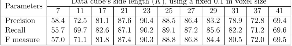
Voxel size λ and dimension of the data sample cube (K) are two important hyperparameters of the proposed model, which have to be carefully tuned with respect to the data density and the recognizable classes. We have optimized these parameters with a grid search algorithm, which yielded an optimum of λ= 0.1m and K = 23, regarding our Riegl VMX-450 data, as mentioned in Sec. 2.4.1. For
1The SZTAKI CityMLS dataset is available at the following url:
http://mplab.sztaki.hu/geocomp/SZTAKI-CityMLS-DB.html
Table 2.1: Performance analysis of the proposed C2CNN method as a function of the voxel size parameter.
Parameters Voxel sizeλ[m], using a fixedK = 23 kernel size
0.02 0.05 0.1 0.2 0.3 0.4 0.5
# of voxels 812500000 52000000 6500000 812500 240596 101563 52000
Precision 34.7 77.8 90.4 83.6 76.3 64.2 44.7
Recall 29.8 69.7 90.2 85.9 77.8 61.7 48.5
F measure 32.1 73.5 90.3 84.7 77.0 62.9 46.5
Table 2.2: Performance analysis of the proposed C2CNN method as a function of the data cube size K×K×K
Parameters Data cube’s side length (K), using a fixed 0.1 m voxel size
7 11 17 21 23 25 27 29 31 37 41
Precision 58.4 72.5 81.1 87.6 90.4 88.5 86.4 83.2 78.9 72.8 69.4 Recall 55.7 69.7 82.6 87.1 90.2 89.1 87.2 85.6 82.2 71.2 69.6 F measure 57.0 71.1 81.8 87.4 90.3 88.8 86.8 84.4 80.5 72.0 69.5
further analysis, Table 2.1 shows the model performance as a function of different λ voxel size settings, with a fixed K = 23 value. We can observe a maximal performance at λ= 0.1m. Using smaller voxels, the model tends to oversegment the scene, while adopting a too large voxel size, the CNN-based label prediction yields coarse region boundaries.
On the other hand, Table 2.2 demonstrates the dependence of the results on the data cube’s side length (K), with choosing a constant voxel grid resolution of λ= 0.1m. Using significantly smaller kernels than the optimalK = 23, the model can only consider small local voxel neighborhoods, which do not enable efficient contextual modeling. However, in cases of too large kernels, the training/test samples may contain significant noise and irrelevant background segments, which fact often leads to overfitting problems.
2.5 Experimental Results and Evaluation 25
2.5.3 Evaluation and comparison to reference techniques
We evaluated our proposed method against four reference techniques in qualita- tive and quantitative ways on the SZTAKI CityMLS dataset.
Figure 2.8: Qualitative comparison of the results provided by the three reference methods, (c) OG-CNN, (d) Multi-view approach and (e) PointNet++, and the proposed (f) C2CNN approach in a sample scenario. For validation, Ground Truth labeling is also displayed in (b).
First, we tested a single channel 3D CNN [29], which uses a 3D voxel oc- cupancy grid (OG) as input (OG-CNN). Second, we implemented a multi-view method based on [51], that projects the point cloud onto different planes, and achieves CNN classification in 2D. Third, we tested the PointNet++ [26] deep learning framework, using their publicly available source code. Finally we adopted the implementation of SPLATNet3D [30], by applying two different feature se- lection strategies.
Fig. 2.8 shows a sample scene for qualitative comparison of the manually edited Ground Truth, the outputs of the OG-CNN, multi-view and PointNet++
methods, and the result of the proposed two channel C2CNN technique. We also evaluated the proposed and the reference methods in a quantitative way. Table
Table 2.3: Quantitative evaluation of the proposed C2CNN approach and the reference techniques on the new SZTAKI CityMLS dataset.
Class OG-CNN [29] Multi-view [51] PointNet++[26] SPLATNetxyz[30] SPLATNetxyzrgb[30] Proposed C2CNN
Pr Rc F-r Pr Rc F-r Pr Rc F-r Pr Rc F-r Pr Rc F-r Pr Rc F-r
Phantom 85.3 34.7 49.3 76.5 45.3 56.9 82.3 76.5 79.3 82.5 80.9 81.7 83.4 78.2 80.7 84.3 85.9 85.1 Pedestrian 61.2 82.4 70.2 57.2 66.8 61.6 86.1 81.2 83.6 82.6 82.1 82.3 80.4 78.6 79.5 85.2 85.3 85.2 Car 56.4 89.5 69.2 60.2 73.3 66.1 80.6 92.7 86.2 81.5 90.0 85.5 81.1 89.4 85.0 86.4 88.7 87.5 Vegetation 72.4 83.4 77.5 71.7 78.4 74.9 91.4 89.7 90.5 87.1 88.2 87.6 86.4 87.3 86.8 98.2 95.5 96.8 Column 88.6 74.3 80.8 83.4 76.8 80.0 83.4 93.6 88.2 84.3 90.2 87.2 84.1 89.2 86.6 86.5 89.2 87.8 Tram/Bus 91.4 81.6 86.2 85.7 83.2 84.4 83.1 89.7 86.3 82.1 83.5 82.8 79.3 82.1 80.7 89.5 96.9 93.0 Furniture 72.1 82.4 76.9 57.2 89.3 69.7 84.8 82.9 83.8 84.7 86.2 85.4 82.6 81.3 81.9 88.8 78.8 83.5 Overall 76.9 74.2 75.5 72.5 73.4 72.9 85.6 87.5 86.5 83.5 85.9 84.7 82.5 83.7 83.0 90.4 90.2 90.3 Note: Voxel level Precision (Pr), Recall (Rc) and F-rates (F-r) are given in percent (overall values weighted
with class significance).
2.3 shows the voxel level precision (Pr), recall (Rc) and F-rates (F-r) for each class separately as well as the overall performance weighted with the occurrence of the different classes. Note that Table 2.3 does not contain the values obtained regarding facades and ground, which classes proved to be quite easy to recog- nize for the CNN network (over 98% rates), thus their consideration could yield overrating the performance of the object discrimination abilities of the method.
By analyzing the results, we can conclude that the proposed C2CNN can clas- sify all classes of interest with an F-rate larger than 83%. The precision and recall rates for all classes are quite similar, thus the false negative and false posi- tive hits are nearly evenly balanced. The two most efficiently detected classes are the tram/bus, whose large planar sides are notably characteristic, and vegetation, which usually correspond to unorganized point cloud segments on predictable po- sitions (bushes on street level and tree crowns at higher altitude). Nevertheless, classes with high varieties such as phantoms, pedestrians and cars are detected with 85-87% F-rates, indicating balanced performance over the whole scene.
Since SPLATNet is able to consider both geometry and color information associated to the points, we tested this approach with two different configura- tions. SPLATNetxyz deals purely with the Euclidean point coordinates (similarly to C2CNN and all other listed reference techniques), while SPLATNetxyzrgb also exploits rgb color values associated to the points. As the results confirm in the considered MLS data SPLATNetxyz proved to be slightly more efficient, which is
2.5 Experimental Results and Evaluation 27
a consequence of the fact, that automated point cloud texturing is still a crit- ical issue in industrial mobile mapping systems, which is affected by a number of artifacts. The overall results of the four reference techniques fall behind our proposed method with a margin of 14.8% (OG-CNN), 17.4% (multi-view), 3.8%
(PointNet++), and 5% (SPLATNetxyz) respectively. While the overall Pr and Rc values of all references are almost equal again, there are significant differences between the recognition rates of the individual classes. The weakest point of all competing methods is the recall rate of phantoms, which class has diverse ap- pearance in the real measurements due to the varying speed of both the street objects and the scanning platform. For (static) cars, the recall rates are quite high everywhere, but due to their confusion with phantoms, there are also many false positive hits yielding lower precision. By OG-CNN, many pedestrians are erroneously detected in higher scene regions due to ignoring the elevation channel, which provides some global position information for the C2CNN model, mean- while preserving the quickness of detection through performing local calculations only.
Apart from the above detailed evaluation on theSZTAKI CityMLSdataset, we also tested our method on various existing point cloud benchmarks mentioned in Sec. 2.3. On one hand, we trained the C2CNN method on the annotated part of the TerraMobilita dataset [36], and predicted the class labels for different test regions. Some qualitative results of classification are shown in Fig. 2.9, which confirm that our approach could be suited to this sort of sparser measurement set as well, however the number of annotated street objects for training should be increased to enhance the results. We can expect similar issues regarding theParis- rue-Madame dataset [35], while our model does not suite well theSemantic3D.net data [37], where the point cloud density is drastically varying due to usage of static scanners.
Figure 2.9: Test result on the TerraMobilita data.
Next, we demonstrate that our method can also be adopted to the Oakland point clouds [38]. Since that dataset is very small (1.6M points overall), we took a C2CNN network pre-trained on our SZTAKI CityMLS dataset, and fine tuned the weights of the model using the training part of the Oakland data. Gener- ally, theOakland point clouds are sparser, but have a more homogeneous density than SZTAKI CityMLS. As sample results in Fig. 2.10 confirm, our proposed ap- proach can efficiently separate the different object regions here, although some low-density boundary components of the vehicles may erroneously identified as phantoms. Using the Oakland dataset, we can also provide quantitative com- parison between the C2CNN method, the reference techniques from Table 2.3, and also the Max-Margin Markov Network (Markov) based approach presented in [38]. Table 2.4 shows again the superiority of C2CNN over all references. Both Markov [38] and the C2CNN methods are able to identify the vegetation, ground and facade regions with around 95-98% accuracy, but for pole-like objects, street furniture and vehicles the proposed method outperforms the reference technique with 8-10%. In addition, we have tested the proposed method on theToronto 3D [102] andParis-Lille-3D [103] databases. Without retraining the original network the qualitative results (Fig. 2.11) are promising, however fine-tuning the weights can increase the accuracy.
2.5 Experimental Results and Evaluation 29
Table 2.4: Quantitative comparison of the proposed method and the reference ones on the Oakland dataset. F-rate values are provided in percent.
Class Markov [21] PointNet++[7] OG-CNN [15] Multi-view [18] SPLATNet [20] Proposed C2CNN
Vegetation 97.2 91.1 87.3 70.4 84.2 96.5
Ground 96.1 91.8 88.8.1 73.4 92.9 98.6
Facade 95.7 96.3 80.7 68.7 90.1 97.7
Pole-like 64.3 79.2 52.1 45.9 70.6 73.3
Vehicle 67.8 68.0 59.4 60.5 66.2 74.7
Street fur. 59.3 73.4 64.7 59.2 66.8 71.4
Figure 2.10: Test result on the Oakland data.
![Figure 1.1: Semantic labeling results of the proposed method [2] (Topic 1).](https://thumb-eu.123doks.com/thumbv2/9dokorg/1298544.104392/21.892.172.763.578.936/figure-semantic-labeling-results-proposed-method-topic.webp)
![Figure 1.2: Projection results of the proposed target-less, automatic camera-Lidar calibration method [1].](https://thumb-eu.123doks.com/thumbv2/9dokorg/1298544.104392/23.892.174.762.212.433/figure-projection-results-proposed-target-automatic-camera-calibration.webp)