Contents lists available atScienceDirect
Journal of Archaeological Science: Reports
journal homepage:www.elsevier.com/locate/jasrep
Neolithic land-use, subsistence, and mobility patterns in Transdanubia: A multiproxy isotope and environmental analysis from Alsónyék – Bátaszék and Mórágy – Tűzkődomb
Margaux L.C. Depaermentier
a,⁎,1, Anett Osztás
b,2, Eszter Bánffy
c,3, Kurt W. Alt
d,e,4, Michael Kempf
f,g,5aDepartment of Early Medieval and Roman Provincial Archaeology, University of Basel, Basel, Switzerland
bResearch Centre for the Humanities, Institute of Archaeology, Budapest, Hungary
cRomano-Germanic Commission of the German Archaeological Institute, Frankfurt/Main, Germany
dCenter of Natural and Cultural Human History, Danube Private University, Krems-Stein, Austria
eDepartment of Integrative Prehistory and Archaeological Science, University of Basel, Basel, Switzerland
fDepartment of Archaeology and Museology, Masaryk University, Brno, Czech Republic
gInstitute of Environmental Social Science and Geography, University of Freiburg, Freiburg, Germany
A R T I C L E I N F O Keywords:
Environmental archaeology Hungary
Migration Strontium isotope Oxygen isotope Lengyel culture
A B S T R A C T
A variety of interdisciplinary research on mobility and migration patterns in Neolithic Hungary has recently contributed to the explanatory models of the Neolithisation across Europe. Most of these models were based on a combination of the spatial distribution of material culture or bioarchaeological and genetic analyses to de- termine large-scale migration and social or population-dynamic development. This paper aims at contributing to the current discussion by introducing a comprehensive and interdisciplinary multivariate environmental and multiproxy strontium and oxygen isotope analyses in combination with detailed archaeological interpretation of unique Neolithic site-complexes in southern Transdanubia. The integration of historical and modern environ- mental attributes, bioarchaeological data, and material typology allows for the determination of small- and large-scale mobility patterns and subsistence strategies in southern Hungary.
1. Introduction
The Carpathian Basin played a major role in the spread of the Neolithic in Central and western Europe. Although Neolithic research is an essential part of Hungarian Archaeology since the 19th century, certain areas were poorly investigated. Scientific interest in the region has significantly increased after the discovery of the Early Neolithic Starčevo settlements in southern Transdanubia in the late 1970s (Kalicz, 1990, 2011) and the first Sopot assemblages recognized in western Hungary somewhat earlier (Kalicz and Makkay, 1972a,b).
Furthermore, recent field work and large-scale rescue excavations in particular, provided new insights into the area south of Lake Balaton (Jakucs and Voicsek, 2015; Marton and Oross, 2012; Oross, 2004;
Osztás et al., 2012). Based on this data, several research projects were focusing not only on spatial dimensions of the respective site, but also on a larger regional framework. Among others, the aim of these projects that included geomagnetic surveys, radiocarbon dating, and aDNA analysis, was to provide innovative interpretations of cultural adapta- tion, chronological categorisation, and the relationship between the respective cultural communities during the Neolithic in the Carpathian Basin (Jakucs et al., 2016; Rassmann et al., 2020; Szécsényi-Nagy et al., 2015). In this context, the socio-cultural relations among Neolithic settlements and the spatial organisation of communities in larger net- works are of central importance in current Neolithic archaeology (Bánffy et al., 2016; Furholt et al., 2020). Although sufficient material culture knowledge and several typo-chronological models have been
https://doi.org/10.1016/j.jasrep.2020.102529
Received 8 June 2020; Received in revised form 26 July 2020; Accepted 14 August 2020
⁎Corresponding author.
E-mail address:m.depaermentier@unibas.ch(M.L.C. Depaermentier).
1Orcid: 0000-0002-1801-3358.
2Orcid: 0000-0002-8470-0770.
3Orcid: 0000-0001-5156-826X.
4Orcid: 0000-0001-6938-643X.
5Orcid: 0000-0002-9474-4670.
Available online 28 August 2020
2352-409X/ © 2020 The Authors. Published by Elsevier Ltd. This is an open access article under the CC BY-NC-ND license (http://creativecommons.org/licenses/by-nc-nd/4.0/).
T
developed, the spatial extent of Neolithic human activity ranges, agri- cultural subsistence economies, and the organisation of social networks and communication patterns on the small-, micro-, and supra-regional scale remain hypothetical. In this context, aDNA and (stable) isotope studies have focused on the ‘verification’ of migration and mobility patterns of Neolithic peoples through tracing human social behavior, dietary habits, and kinship relations on various spatial scales and over long chronological periods (Alt et al., 2014; Giblin et al., 2013;
Szécsényi-Nagy et al., 2015). The data offered wide-ranging com- plementary information to further elucidating the process of genetic differentiation across Europe and the development of agricultural strategies and opportunities from the Early Neolithic onwards. Fur- thermore, recent landscape archaeological analyses and the re- construction of potential land-use strategies in Neolithic Hungary have proven to be useful tools to determine human land-use systems and strontium isotope baselines, thus enabling the interpretation of mobility patterns on the site-specific and the micro-regional scale (Depaermentier, in preparation; Kempf, in preparation; Kempf, sub- mitted). In this context, the integration of multivariate environmental data, archaeological records, and (stable) isotope values into one mul- tiproxy analysis is the key to understand the dynamic and manifold interconnections between environmental stressors, socio-economic vulnerability, landscape development, and human adaptation processes that control the establishment of (spatially) local subsistence agri- culture and animal husbandry (Ivanova et al., 2018).
As part of a German-Hungarian interdisciplinary research project that aimed to investigate the structure and dynamics of settlement and population development during the Neolithic in the Carpathian Basin, this paper presents a case study from the Neolithic site-complex at Alsónyék–Bátaszék and the adjacent site at Mórágy-Tűzkődomb (Fig. 1) in south-east Transdanubia (abbreviated as Alsónyék and Mórágy hereinafter). The results include the first strontium and oxygen isotope data published for Starčevo, Sopot, and Lengyel cultures in Transda- nubia. The aim of this paper is to integrate archaeological data and multivariate environmental analyses to interpret strontium and oxygen stable isotope data in terms of mobility patterns from the site-specific to the regional and supra-regional scale. This dataset enables the discus- sion about different forms of mobility in a diachronic perspective that include not only potential large-scale migrations (which are usually expected in a Neolithisation context), but also socio(-political) re- lationships in an exogamy context as well as mobility related to land- use strategies. According to the project outlines, a strong inter- disciplinary research framework allowed for the determination of a potential palaeolandscape, spatially local agricultural opportunities, Neolithic site continuities, and an intense supra-regional exchange and communication (Depaermentier, in preparation; Kempf, in preparation;
Kempf, submitted).
2. Archaeological settings
Mórágy and Alsónyék are among the most thoroughly investigated Lengyel sites in southeastern Transdanubia. Over 300 Lengyel sites are currently known in Hungary, about half of them are located in southern Transdanubia (Zalai-Gaál, 2008), which points towards a dense settle- ment network during the Late Neolithic. In this chapter, we primarily focus on the contexts of the samples and present the burials from each subsite.
2.1. The Alsónyék site
The Alsónyék site is located between the foothill zone of the Szekszárd Hills and the large alluvial plains of the river Danube pa- laeochannel system (Fig. 1A). It was excavated between 2006 and 2009 in the course of the construction of the M6 motorway (Osztás et al., 2016a). The excavated area covers about 25 ha and brought to light about 15,000 archaeological features spanning almost the entire 6th
millennium and the first and second third of the 5th millennium cal BC, encompassing four main Neolithic occupations (Table 1): the Starčevo (ca. 5800–5500 BCE), the LBK (Linearbandkeramik, ca. 5360–4860 BCE), the Sopot (ca. 5200–4680 BCE), and the Lengyel period (ca.
4900–4400 BCE) (Osztás et al., 2012). One of the main reasons for the long-lasting and almost continuous site occupation is the location at the transition from the hilly margins to the marshy lowlands, which pro- vided potential agricultural zones, pasture, and fresh-water access (Kempf, submitted). Furthermore, the area is situated in a contact zone between Neolithic populations of the northern Balkans and Central Europe, which triggered a constant flow of goods and ideas and favored a strong mobility of people, particularly from the south (Osztás et al., 2012).
2.1.1. The Starčevo period
The Starčevo occupation concentrated in the southern part of the site (5603, Bátaszék-Mérnökségi Telep subsite, BAM inFig. 1A) and its archaeological features, the amount of findings, and the large scale of the site represent a unique Starčevo complex in Hungary (Osztás et al., 2016a; Osztás et al., 2012). In total, 25 Starčevo human individuals have been identified on subsite 5603 (BAM). Among them were seven subadults, six males, ten females, and two adults of undeterminable sex (Köhler, 2015). The graves were scattered randomly across the site, with some small clusters that included 2–4 individuals. The orientation of the skeletons did not show any consistent pattern, but the left- crouched body position dominated. Human remains were mostly buried in the fillings of different types of settlement pits, however, also some isolated burials were found. Among the frequently recorded vicinity to ovens, the most interesting burials can be considered the five in- dividuals that were buried inside the ovens without any burning traces (graves 792, 1398, 1362, 1449, and 153 (Bánffy et al., 2017). This phenomenon has not yet been observed within a Starčevo context so far. Only one Starčevo individual (grave 727) was buried with grave goods. In this paper, the isotope samples from Early Neolithic contexts deriving from this part of the site are labelled BAM.
2.1.2. The LBK period
The LBK settlement at Alsónyék represents one of the southernmost LBK occupations in Transdanubia. LBK features concentrated in the central part of the excavated area (Fig. 1A) which is supposed to form a coherent settlement (Osztás et al., 2012). The remains of some 50 houses were identified in total. Five graves can be assigned to the LBK, which were dug into the long pits of houses (Oross et al., 2016b). One sample collected for this project was radiocarbon dated to LBK (BAL25, 5208–4948 cal BC, 2 σ). The dating was conduted at the Poznañ Radiocarbon Laboratory (lab code: POZ).
2.1.3. The Sopot period
A very rich and important assemblage of Sopot material was found in approximately 1.5 km distance to the east of the LBK site (Fig. 1A).
The settlement, which featured a broad variety of pits and ditches, was surrounded by a system of two overlapping double ditches that were limited to the north by a former river channel of the river Sárvíz (Rassmann et al., 2015). During the excavation, eighteen skeletal graves with the remains of twenty individuals and two cremations were recorded at the Alsónyék, Hosszú dűlő (5603/2 = ALE) subsite (Oross et al., 2016c; Osztás et al., 2012). Some of the Sopot graves sealed the ditch system and numerous burials were stratigraphically related to each other. Most of the bodies were buried in a crouched position: ten were left-crouched, five were right-crouched and two or three in- dividuals were buried in a supine position. The orientation of the burials varied between NE-SW and SE-NW with a predominance of NE- SW position. The forms of the grave pits vary between oval and rec- tangular. However, it was not possible to reconstruct the original pit form in all cases. Four individuals were buried in rectangular pits (graves 217, 432, 475, and 476). Compared to the previous LBK period
in Transdanubia, the number and the variety of grave goods increased considerably: among others, particularly the graves 464, 470, and 476 were richly furnished. Different types of ceramic vessels occurred to be the most frequent grave goods. However, also Spondylus and red deer canine teeth ornaments as well as chipped and polished stone artefacts were found. Samples marked with ALE in this paper originated from this subsite.
2.1.4. The Lengyel period
Alsónyék reached its greatest extent during the Late Neolithic Lengyel period (Fig. 1A). Nearly 9000 of the almost 15,000 excavated
features can be associated with the Lengyel phase - including approxi- mately 2300 burials, numerous pits and pit complexes, and 122 post- framed houses (Osztás, 2019; Osztás et al., 2016b). The traces of the Lengyel occupation cover the entire excavated area. It has been esti- mated that the site could have been covering up to 80 ha in its max- imum extent (Osztás et al., 2016a). Ditch sections that were uncovered in the northern, eastern, and southern margins of the excavations may indicate the actual boundaries of the settlement. The western part is most likely limited by the margins of the adjacent hills.
A large part of the burials was found in spatially discrete groups, sometimes compact and clearly separated, with clusters of 25–35 Fig. 1.(A) Historical landcover from 1782 and excavation plan at Alsónyék (the abbreviations BAM, BAL, ALE indicate the location of the sampled subsites within the site-complex). The excavated area shows Starčevo, LBK (Linearbandkeramik), Sopot, and a large-scale Lengyel period occupation. The latter covers almost the total excavated area. (B) Historical landcover from 1782 and the location of the site at Mórágy (samples from this site are abbreviated as MORT) (seeOsztás et al., 2012, 380,Fig. 2for the excavation plan and the subsites).
burials to clusters of about 100 burials. But in general, they were rather diffuse and overlap or merge spatially. Several scattered graves were also uncovered, some of which were buried into the pits or in the locale of former houses. Most of the graves faced in E–W direction and the body was deposited in a crouched position. The grave pits were mostly oval-shaped. Furthermore, a new type of construction, which corre- sponds to a rectangular pit with postholes in the four corners was dis- covered at Alsónyék. These graves were particularly frequent in the northern part of subsite 10B and featured rich grave good assemblages.
Compared to other types of burials, these graves contained large amounts of polished and chipped stone tools, copper, and imported shell ornaments (SpondylusandDentalium). The pottery types found in the graves varied greatly in shape and size and did not show significant differences from pottery of other south-eastern Transdanubian burials dating to the same period.
In this study, the 27 human individuals sampled for strontium and oxygen isotope analyses originated from the subsite 46 (Bátaszék, Lajvérpuszta, marked as BAL), which was excavated in 2009 by the National Heritage Protection Centre of the Hungarian National Museum. The samples were taken from a roughly compact grave group in the south-eastern part of the subsite where it connects to the south- western part of subsite 10B. From the 55 Lengyel burials, 36 individuals were lying on their left side, nine on their right side, one laid in supine position, and the position of the other individuals could not be ob- served. The most typical orientation ranged between NE-SW and E-W.
Roughly one-fifth of the burials did not contain grave goods and the most common were pots, animal bones, and to a lesser extent chipped and polished stone tools.
2.2. The Mórágy-Tűzkődomb site
The site of Mórágy lies in south-eastern Transdanubia (Fig. 1B) and was investigated during a small-scale, but long-lasting excavation pro- ject between 1978 and 1990 led by István Zalai-Gaál (Zalai-Gaál, 2001b, 2002). This was the first systematic research excavation in southern Transdanubia after the 1930′s-1940′s excavations of Lengyel sites in the Baranya county (Dombay, 1939, 1958, 1959, 1960). The excavation of almost 2200 m2brought to light a variety of Lengyel features, including 109 Lengyel graves (Zalai-Gaál, 2001b). Two main areas were investigated through several trenches and two grave groups were unearthed, of which 86 graves formed the grave group B1 (Zalai- Gaál, 2002). However, due to erosion processes, ploughing activity, and the extent of the excavation, it is probable that it was not recorded entirely (Zoffmann, 2004). A part of a second grave group was ex- cavated, which was recorded and interpreted as a different group (grave group B2) (Zalai-Gaál, 2001b). At Mórágy the bodies were crouched and over half of the burials were oriented in W–E direction (heads fa- cing the west, bodies lying on their right sides) (Zalai-Gaál, 2010). Only a few (about 5%) graves were not furnished, more than 85% of the graves contained pots or pottery fragments (Zalai-Gaál, 2010). In grave group B1, the low number of male burials and of burials with polished stone tools are remarkable compared to other Lengyel burial sites (Zalai-Gaál, 2010). Furthermore, a remarkably large number of burials (n = 21) contain artefacts such asSpondylus, Dentaliumand copper (Zalai-Gaál, 2010). The analysis of over 650 burials from southern Transdanubia led to the establishment of a relative chronological Len- gyel development and to important socio-archaeological studies using quantitative attributes (Zalai-Gaál, 2001a, 2010). These analyses have contributed greatly to the understanding of the period’s social organi- sation and relative chronology of the Lengyel culture. In this study, the 20 sampled individuals belong to the north-eastern part of the grave group B1. In this paper, the sampled material from Mórágy is labelled MORT.
Table1 Numberofindividualsfromeachsiteandeacharchaeologicalculturesampledforstrontiumand/oroxygenisotopeanalyses.TheradiocarbondatingoftheLengyeloccupationatMórágyisbasedonrelativechronology andceramicseriations. SiteAbbr.ArchaeologicalcultureAbsolutechronology(basedonradiocarbondating)Numberofindividualssampledforisotope analysesReferences BeginoftheoccupationEndoftheoccupationstrontiumoxygen Bátaszék-MérnökségiTelepBAMStarčevo5800–5730calBC(2σ)or5775–5740calBC (1σ)5575–5505calBC(2σ)or5560–5525calBC (1σ)1618Orossetal.(2016a) Bátaszék,LajvérpusztaBALLBK5365–5230calBC(2σ)or5335–5280calBC (1σ)5040–4860calBC(2σ)or5010–4915calBC (1σ)10Orossetal.(2016b) Alsónyék,HosszúdűlőALESopot5200–5005calBC(2σ)or5095–5020calBC (1σ)4850–4680calBC(2σ)or4825–4750calBC (1σ)1315Orossetal.(2016c) Bátaszék,LajvérpusztaBALLengyelearly48thcenturycalBCendofthe44thcenturycalBC2320Osztásetal.,2016b Mórágy-TűzkődombB1MORTLengyel4715–4660calBC4180–4050calBC2019Zalai-Gaáletal.(2014)
3. Geographical settings
In this section, the environmental details of the site complexes are described and the differences in location parameters, sedimentological properties, and soil composition are presented. Important features of the potential agriculturally utilised areas are compared to flooding vulnerability and historical landcover change in Transdanubia (Bánffy, forthcoming; Kempf, submitted). In this context, the analysis of his- torical maps in terms of landcover and land-use change as well as premodern landscape dynamics are useful tools to come closer to an understanding of prehistoric surface conditions (Kempf, 2020). How- ever, it must be pointed out that these analyses have methodological limitations and do not necessarily allow for the reconstruction of past landscapes and in particular potential agricultural conditions of pre- historic societies.
3.1. The Alsónyék site
The site is situated on the right bank of the river Danube in close direction to the western hilly margins of southern Transdanubia (Osztás et al., 2012). The sites are located outside the Holocene floodplain of the river Danube but closely connected to a tributary fluvial system that drains the gentle slopes. According to military observations and his- torical literature from the early 19th century (Bright, 1818; Kienreich, 1839), the north-south running system of the river Sárvíz (river Sarvitz/
Sarwitz/Sarwiz) that drained the Lake Balaton (Johnston, 1850), pro- duced a broad interconnected floodplain with several island-like pla- teaus and extensive wetlands, swamps, and morasses, which were “not only useless, but pestiferous” (Fig. 2) (Kimball, 1850). The floodplain further controlled the distribution of arable land prior to extensive regulations and channelisation activities in the 19th and 20th centuries (Ujházy and Biró, 2018). Due to a high flooding vulnerability and periodical inundation of the low-lying areas between the islands, the area could have been considered susceptible to waterlogged soils and a high natural ground-water level. Crop-cultivation would have therefore been at high risk of harvest loss. The historical landcover from the second half of the 18th century shows distinct boundaries between the broad floodplain to the east and the agriculturally utilised areas in between the western slopes and the terraces of the river Sárvíz (Fig. 1).
In particular, the location of the Sopot site is characterised by close connection to fresh water along a potential palaeochannel of the Da- nube tributary Sárvíz. The former riverbed has accumulated fine- grained material due to low run-off velocity, which is visible in the oxbow-shaped wetland north of the site.
The site complex at BAM/BAL is situated west of the floodplain and outside the extensive flooding area. However, the complex is located at a secondary tributary (river Lajvér) that drains the hills to the west. The historical map clearly indicates the shifting flow-regime of the river, which cuts the excavation area in half. The disturbances in the middle of the excavation are caused by the canalisation of the Lajvér riverbed during the 19th/20th century. A meandering flow-regime and peri- odically shifting accumulation properties of the hydrological system prior to the canalisation, have covered the Neolithic settlement with considerable sediment deposits originating from the western hills.
Geological conditions are dominated by continuous sedimentation processes characterised by periodical flooding events, the accumulation of fine-grained material (mostly clayey deposits and silty material), and relocation processes of loess deposits from the adjacent loess plateaus (Molnár et al., 2019). The accumulation regime shows gradual differ- entiation of material deposition with significant transition towards the elevated hillslopes. Sandy and coarse-grained material deposits are covered with recent alluvial sediments from the tributaries. That in- dicates multifold sedimentation processes: an eastern, Danube-domi- nated sedimentation regime caused by the anastomosing character of the river in the early Holocene, a secondary, more recent fine-grained filling of the palaeochannels and levees through the small-scale
tributary system draining the hills, and an interspersed aeolian cover that has not experienced recent fluvial relocation (Kempf, submitted).
The soil composition represents mixed meadow soils; however, the fluvial deposits of the river show distinct sedimentological stratification in contrast to the surrounding, mostly wind-blown deposits of the transition zone between floodplain and elevated area. Isotopic signals and soil texture and conditions at BAM/BAL would rather be compar- able to the original geological basis around the Mórágy site complex (MORT).
3.2. The Mórágy-Tűzkődomb site
The site at Mórágy (MORT) is characterised by Pliocene, Miocene, and Quaternary sediments covering a complex geological basement of various granite bodies, migmatites, and Jurassic and Cretaceous out- crops (Kercsmár et al., 2015; Márton, 1980). The uppermost 50 m of the granitoid body are strongly weathered and the sediment coverage thins towards the incised valleys (Tóth, 2018). According to the pedological map (Fig. 2b), soil composition and texture are entirely different at Mórágy compared to the lowlands. Skeletal and Brown Forest soils are mostly abundant (Laborczi et al., 2016; Pásztor et al., 2018). Towards the valleys, relocated material forms meadow soils and mixed signals.
As pointed out for Alsónyék, the material relocation could affect the sedimentological stratification in close distance to the lower foothills.
In this context, silty material from the Quaternary coverage at Mórágy would be relocated and accumulated in considerable thickness at Al- sónyék. Furthermore, the satellite imagery (Fig. 2c) reveals significant difference in land-use opportunities between MORT and the adjacent floodplain. This is ultimately tied to soil properties and a potentially low-lying aquifer of the hilly margins (low and moderately productive porous aquifers (EGDI, 2020)).
The comprehensive geographical landcover evaluation and the historical data analysis provide the basis for the interpretation of the isotopic data comprised in this paper. Agricultural strategies and local human activity ranges will be considered to determine site-specific and micro-regional isotopic signals. In the following sections, the multi- variate surface model will be described, followed by the results of the palaeolandscape and the isotopic analysis.
4. Material and methods
A variety of environmental datasets were used to display the het- erogeneous geological, pedological, and hydrological conditions in the study area (Kempf, in preparation; Kempf, submitted). The data was processed with ©QGIS 2.8.9 and ©GRASS 7.4; ©QGIS 3.6.0 and
©GRASS 7.6.0. Statistical modelling and isotope analysis were per- formed using R software (©R 3.5.1). Satellite data was manipulated in
©multispec (Purdue University) and finally visualised in QGIS. More- over, no statistical significance tests are carried out in this study be- cause it was considered inappropriate regarding the small sample size per cultural group.
4.1. Environmental data
A 25 m grid cell digital elevation dataset was downloaded from the USGS (ASTER GDEM is a product of METI and NASA, https://
earthexplorer.usgs.gov/, last accessed 24th of July 2019).
Multispectral satellite imagery is available free of charge from the USGS and the ESA (Copernicus open access hub: USGS:https://earthexplorer.
usgs.gov/, last accessed: 22nd of July 2019). Geological datasets (1:100 k) derived from MBFSZ as WMS layer (https://map.mbfsz.gov.
hu/, last accessed 24th of July 2019) and the EGDI datasets (European Geological Data Infrastructure;http://www.europe-geology.eu/about- egdi/, last accessed 24th of July 2019 (EGDI, 2020)). Digital soil units, textures and excess water hazard maps were kindly provided by László Pásztor and his team from the Hungarian Institute for Soil Science and
Agricultural Chemistry at the Hungarian Academy of Sciences, Buda- pest, Hungary (Laborczi et al., 2016; Laborczi et al., 2019; Pásztor et al., 2018; Pásztor et al., 2015a,b). Historical maps from the 18th century CE were extracted from mapire.eu (last accessed 06th of April 2020), georeferenced and finally analysed to estimate historical landcover and particularly the hydrological system prior to the massive canalisation processes during the 19th and 20th centuries.
4.2. Isotope data and analyses
In this study, a total of 79 individuals from two Neolithic sites of present-day Hungary were sampled for strontium and oxygen isotope analyses. Three individuals among them were only sampled for stron- tium and three others only for oxygen isotope analyses (Tables 1 and 2).
As far as possible, at least two teeth were analysed to gain insights into different steps of an individual’s childhood and the related mobility patterns. In general, each site provided approximately the same number of males and females, and the last third of the sample comprised sub- adult individuals (infants and juveniles) that were not sex-determined.
The morphological sex was determined by the method introduced by Éry et al. (1963). The anthropologists recorded metric and morpholo- gical characteristics, which are showing the sexual dimorphisms. These included eight skull, four jaw, and eleven postcranial characteristics (Éry et al., 1963). At Bátaszék-Mérnökségi telep (BAM), the sample represented the Starčevo culture. The sample from Alsónyék, Hosszú dűlő (ALE) corresponded to the Sopot culture, one sample from
Bátaszék Lajvérpuszta (BAL) was dated to the LBK, and the Lengyel culture was represented at two sites: Bátaszék, Lajvérpuszta (BAL) and Mórágy–Tűzkődomb B1 (MORT) (Fig. 1). Furthermore, 15 human bones, 14 faunal dental enamel and 4 modern shells were sampled at these sites to determine a strontium isotope baseline (Table 3). The secure dating of the sampled contexts partly based on radiocarbon dates or on the associated material composition of the findings (Regenye, 2002). The radiocarbon measurements were mostly conducted at the Curt-Engelhorn-Zentrum Archäometrie in Mannheim, Germany (lab code: MAMS).
Strontium isotope analyses were led on the above-mentioned ma- terial following the methods described by Knipper in 2012 (Knipper et al., 2012) to investigate human mobility patterns at two different sites from the Sárköz region. The composition of the locally bioavail- able strontium, which is introduced in the food chain though the ve- getation, depends on bedrock properties and geological settings (Bentley, 2006; Montgomery, 2010; Price et al., 2012). The strontium isotope composition of food is furthermore transferred to human dental enamel and bone apatite after the consumption (Bentley, 2006;
Montgomery, 2010; Price et al., 2002), which means that the87Sr/86Sr ratios measured in human dental enamel bear information on an in- dividual’s location at the moment of the mineralisation of its sampled tooth (Knipper, 2017). The determination of the strontium isotope baseline in a study area enables interpreting these data in terms of mobility patterns: if the87Sr/86Sr ratio of an individual’s dental enamel does not match the 87Sr/86Sr ratio that is expected at the site, this Fig. 2.Geological, pedological and hydrological map of the MORT, BAM, BAL, ALE complex on the right bank of the Danube. The surface lithology in the study area consists of unsorted or poorly sorted, clastic sediments with a wide range of particle sizes, including a muddy matrix. According to the geological units, BAM, BAL, and ALE cannot be distinguished. The MORT site is located on silty material that can clearly be distinguished (a). All sites lie outside the potential floodplain of the Danube and the larger tributaries. The whole complex is heavily affected by 19th century drainage activity and canalisations which is indicated by the various coupled historical river systems and the broad meadow patches in the Holocene floodplain of the Danube (light green signature) (b). A false color satellite image (channel combination NIR, R, R) from Sentinel-2B MSIL1C 26th December 2017 further visualises bare and poorly vegetated areas that appear blue, areas covered with intact vegetation/ strong agricultural exploitation appear red. The modern residential areas and the cropland extent align with the margins of the potential flooding area. The Neolithic sites are located outside the floodplain along a tributary river system that drains the gentle hills to the west.
Table 2
Human dental enamel sampled of strontium and oxygen isotope analyses and related results.
Grave/Feature No. Sample Sex Age categorie Age (years) Tooth 87Sr/86Sr 2σ δ18OP 1σ
Alsónyék, Hosszú dűlő (Sopot)
210 ALE1 male adult 35–45 M1 (?) 0.71083 0.00003 16.12 0.2
214.B ALE2 female adult 25–30 M3 (28) _ _ 15.35 0.3
214.B ALE2 female adult 25–30 M1 (26) _ _ 16.56 0.2
214.B ALE2 female adult 25–30 no data 0.70948 0.00004 _ _
220.B ALE3 female juvenile 16–18 M1 (36) _ _ 18.30 0.2
220.B ALE3 female juvenile 16–18 M2 (37) 0.70929 0.00004 _ _
220.A ALE4 male adult 35–45 M2 (37) 0.70898 0.00003 _ _
220.A ALE4 male adult 35–45 C (23) 0.70905 0.00001 _ _
240 ALE5 male adult 25–35 M1 (46) _ _ 15.99 0.1
240 ALE5 male adult 25–35 M3 (48) 0.70928 0.00005 16.94 0.0
282 ALE7 undet. infant 13–14 M1 (46) _ _ 17.34 0.2
283 ALE8 female adult 30–40 M1 (16) 0.70903 0.00002 16.78 0.1
283 ALE8 female adult 30–40 M3 (18) _ _ 15.45 0.3
372 ALE9 female juvenile 18–20 M1 (46) _ _ 18.20 0.1
372 ALE9 female juvenile 18–20 M3 (38) _ _ 17.24 0.0
373 ALE10 female adult 25–35 M1 (46) 0.70944 0.00005 17.21 0.3
373 ALE10 female adult 25–35 M3 (48) 0.70948 0.00003 16.23 0.0
396 ALE11 undet. infant ca. 7 M1 (16) _ _ 17.44 0.2
396 ALE11 undet. infant ca. 7 M2 (17) 0.70934 0.00003 _ _
432 ALE12 female adult 25–35 M1 (36) _ _ 17.38 0.1
432 ALE12 female adult 25–35 M3 (38) _ _ 16.12 0.2
432 ALE12 female adult 25–35 no data _ _ 17.40 0.0
463 ALE14 male (genetic.) infant ca.6 m1 (84) 0.70930 0.00001 _ _
464 ALE15 male mature 40–45 M3 (38) 0.70897 0.00002 15.25 0.2
470 ALE16 male adult 35–45 M3 (38) _ _ 16.37 0.2
470 ALE16 male adult 35–45 M1 (36) 0.70900 0.00001 16.31 0.2
471 ALE17 undet. infant ca. 13 M1 (26) _ _ 16.54 0.1
471 ALE17 undet. infant ca. 13 M3 (38) 0.70999 0.00002 _ _
475 ALE18 undet. infant 14–15 M2 (47) 0.70926 0.00003 16.40 0.1
476 ALE19 undet. juvenile 18–20 M1 (36) _ _ 17.65 0.2
Bátaszék, Lajvérpuszta (Lengyel)
26 BAL1 female adult 20–25 M1 (36) 0.70987 0.00004 16.33 0.3
26 BAL1 female adult 20–25 P2 (35) 0.70983 0.00006 16.49 0.4
27 BAL2 female? adult 35–45 M1 (46) 0.71023 0.00006 16.93 0.1
35 BAL3 male mature 40–59 M1 (46) 0.71004 0.00001 16.39 0.3
35 BAL3 male mature 40–59 M2 (47) 0.70999 0.00002 _ _
36 BAL4 female? juvenile 18–20 M1 (46) 0.70970 0.00004 17.03 0.1
36 BAL4 female? juvenile 18–20 M3 (48) 0.70961 0.00006 16.07 0.2
38 BAL5 male adult 30–40 M1 (46) 0.70964 0.00004 16.87 0.3
38 BAL5 male adult 30–40 M3 (48) 0.70958 0.00005 15.91 0.2
39 BAL6 male? adult 35–45 M1 (46) 0.70977 0.00003 16.95 0.1
39 BAL6 male? adult 35–45 M2 (47) 0.70986 0.00003 _ _
40 BAL7 male adult 25–30 M1 (36) 0.70997 0.00002 17.84 0.1
40 BAL7 male adult 25–30 M3 (38) 0.70986 0.00005 16.51 0.0
49 BAL8 undet. infant 6–7 m2 (85) 0.70999 0.00003 17.04 0.1
49 BAL8 undet. infant 6–7 M1 (46) 0.70990 0.00003 _ _
65 BAL9 male mature 40–59 M1 (36) 0.70968 0.00001 16.55 0.0
66 BAL10 male adult 25–35 M1 (36) 0.70994 0.00004 16.07 0.1
66 BAL10 male adult 25–35 M2 (37) 0.70983 0.00003 _ _
68 BAL11 undet. juvenile 17–18 M1 (36) 0.70990 0.00004 16.85 0.0
68 BAL11 undet. juvenile 17–18 M2 (37) 0.70997 0.00004 _ _
69 BAL12 male adult 30–40 M1 (46) 0.71008 0.00005 16.53 0.2
69 BAL12 male adult 30–40 M3 (48) 0.71012 0.00001 _ _
71 BAL13 male? adult 25–35 C (?) 0.70997 0.00002 _ _
72 BAL14 female adult 30–40 M1 (46) 0.71001 0.00002 16.51 0.2
72 BAL14 female adult 30–40 M3 (48) 0.70942 0.00005 17.67 0.1
76 BAL15 undet. adult 35–45 M1 (46) 0.70972 0.00006 16.45 0.3
76 BAL15 undet. adult 35–45 M2 (47) 0.70993 0.00001 _ _
89 BAL16 female adult 25–35 M1 (46) 0.70957 0.00005 16.67 0.3
89 BAL16 female adult 25–35 M3 (48) 0.70948 0.00003 16.75 0.0
34 BAL18 male? adult 25–35 M2/3 (47/48) 0.71002 0.00005 16.99 0.2
41 BAL19 male? mature 40–59 M1 (36) 0.70955 0.00005 16.29 0.1
50 BAL21 female? adult 35–45 M1 (16) 0.70990 0.00001 17.08 0.0
50 BAL21 female? adult 35–45 M3 (18) 0.70980 0.00003 16.13 0.1
51 BAL22 female adult 30–40 M1 (26) 0.70969 0.00001 16.57 0.4
51 BAL22 female adult 30–40 M3 (?) 0.70969 0.00001 _ _
52 BAL23 undet. adult 30–50 M? 0.70970 0.00002 _ _
70 BAL24 female adult 35–45 M1 (26) 0.70956 0.00001 16.31 0.1
70 BAL24 female adult 35–45 M3 (38) 0.70964 0.00003 16.07 0.3
Bátaszék, Lajvérpuszta (LBK)
93 BAL25 male mature 45–55 M? (?) 0.70931 0.00003 _ _
Bátaszék-Mérnökségi Telep (Starčevo)
688 BAM1 female adult 23–27 M1 (16) _ _ 14.83 0.5
(continued on next page)
individual was probably mobile or changed its dietary habits during its life (Bentley, 2006; Brönnimann et al., 2018; Maurer et al., 2012).
Baseline samples originated directly from the sites and were not col- lected from the surroundings. The environmental settings of each site
were not necessarily comparable, hence a site-specific and a micro-re- gional baseline, which included the baseline samples of different sites with different settings, were suggested for each site, following the methods presented in Kempf and Depaermentieret al.(in preparation).
Table 2(continued)
Grave/Feature No. Sample Sex Age categorie Age (years) Tooth 87Sr/86Sr 2σ δ18OP 1σ
721 BAM2 female adult 30–40 M3 (18) 0.70938 0.00003 16.05 0.3
721 BAM2 female adult 30–40 M1 (46) _ _ 17.10 0.2
745 BAM4 male (genetic.) adult 35–45 M1 (36) 0.70955 0.00002 16.59 0.2
745 BAM4 male (genetic.) adult 35–45 M3 (38) 0.70989 0.00004 15.56 0.0
746 BAM5 undet. infant 9–11 M1 (36) 0.70924 0.00006 16.75 0.0
775 BAM6 undet. infant 8–10 M2 (27) _ _ 16.13 0.2
797 BAM8 female adult 35–45 M1 (36) 0.71072 0.00004 _ _
797 BAM8 female adult 35–45 M2/3 (17/18) 0.71067 0.00003 14.64 0.2
1362 BAM10 female adult 30–40 M1 (46) 0.71059 0.00004 15.65 0.5
1362 BAM10 female adult 30–40 M2 (47) 0.71049 0.00002 14.41 0.2
1372 BAM11 male adult 35–45 M1 (46) 0.70991 0.00001 15.72 0.3
1372 BAM11 male adult 35–45 M3 (48) 0.70960 0.00008 16.56 0.2
1435 BAM13 undet. infant 8–9 M1 (16) 0.70960 0.00004 17.27 0.3
1449 BAM15 female? juvenile 17–18 M1 (46) 0.70978 0.00006 17.51 0.1
1449 BAM15 female? juvenile 17–18 M2 (47) _ _ 16.72 0.3
1449 BAM15 female? juvenile 17–18 M3 (28) _ _ 17.45 0.1
1461 BAM16 male mature 45–55 M1/2 0.70928 0.00004 15.72 0.1
1461 BAM16 male mature 45–55 M3 (28) 0.70960 0.00008 13.33 0.3
1483 BAM17 male (genetic.) infant 7–8 M1 (36) 0.70931 0.00004 16.99 0.2
1495 BAM18 female adult 23–30 M1 (36) 0.70967 0.00006 16.08 0.0
1495 BAM18 female adult 23–30 M3 (38) _ _ 15.36 0.2
1513 BAM19 undet. infant 10–12 M1 (26) 0.70952 0.00004 15.86 0.2
1513 BAM19 undet. infant 10–12 M2 (37) _ _ 15.36 0.2
1516 BAM20 female adult 23–27 M1 (46) 0.70955 0.00006 15.22 0.2
1516 BAM20 female adult 23–27 M3 (48) 0.70961 0.0001 13.71 0.2
1531 BAM24 female mature 40–50 M3 (48) 0.70907 0.00003 15.54 0.3
1532 BAM25 male (genetic.) adult 20–30 M1 (46) 0.70946 0.00005 _ _
1532 BAM25 male (genetic.) adult 20–30 M3 (48) 0.70902 0.00001 15.59 0.2
1533 BAM26 male adult 35–45 M3 (48) 0.70909 0.00005 16.28 0.2
Mórágy-Tűzkődomb B1 (Lengyel)
15 MORT1 female senil 62–75 C (13) 0.71196 0.00005 15.60 0.4
16 MORT2 female mature 41–45 M2 (27) 0.70936 0.00004 16.38 0.2
16 MORT2 female mature 41–45 M3 (28) 0.70962 0.00005 16.72 0.2
43 MORT4 undet. infant 9–11 M1 (26) 0.70983 0.00004 16.89 0.1
43 MORT4 undet. infant 9–11 M3 (?) 0.70985 0.00005 16.59 0.1
46 MORT6 undet. infant 9–11 m2 (75) 0.71015 0.00003 18.03 0.3
46 MORT6 undet. infant 9–11 M1 (36) 0.70981 0.00005 16.92 0.1
46 MORT6 undet. infant 9–11 M1 (?) _ _ 17.18 0.3
47 MORT7 undet. infant 13–15 M1 (46) 0.70973 0.00005 16.28 0.0
47 MORT7 undet. infant 13–15 M3 (48) 0.70930 0.00005 15.88 0.1
48 MORT8 female juvenile 21–28 M1 (36) 0.71000 0.00001 18.05 0.1
48 MORT8 female juvenile 21–28 M2 (37) 0.70984 0.00002 _ _
51 MORT9 female infant 65–75 m2 (65) 0.70943 0.00001 16.94 0.1
52 MORT10 undet. infant 2–3 m1 (54) 0.70934 0.00005 17.23 0.2
52 MORT10 undet. infant 2–3 i1 (51) 0.7096 0.00005 16.92 0.2
55 MORT11 male adult 22–28 M1 (46) 0.70965 0.00001 16.47 0.1
56 MORT12 female mature 41–45 M1 (46) 0.70973 0.00002 16.63 0.1
56 MORT12 female mature 41–45 M2 (47) 0.70983 0.00006 _ _
57 MORT13 male mature 54–58 M2 (37) 0.70977 0.00003 15.86 0.1
57 MORT13 male mature 54–58 M3 (38) 0.70957 0.00001 16.22 0.0
59 MORT15 female juvenile 19–21 M1 (36) 0.70958 0.00004 15.96 0.2
59 MORT15 female juvenile 19–21 M3 (18) 0.70979 0.00004 17.00 0.3
60 MORT16 undet. infant 5–6 m2 (55) 0.70986 0.00005 16.73 0.2
60 MORT16 undet. infant 5–6 M1 (?) 0.70998 0.00004 16.20 0.2
63 MORT18 undet. infant 9–11 m2 (75) 0.70949 0.00005 18.48 0.2
63 MORT18 undet. infant 9–11 M1 (36) 0.70934 0.00002 18.67 0.0
65 MORT19 female mature 47–63 M1 (36) 0.70955 0.00003 _ _
65 MORT19 female mature 47–63 M2 (37) 0.70997 0.00003 _ _
66 MORT20 male adult 37–43 M1 (36) 0.71004 0.00003 15.98 0.4
66 MORT20 male adult 37–43 M3 (18) 0.70974 0.00002 15.62 0.2
67 MORT21 female adult 30–36 M1 (36) 0.70978 0.00003 16.98 0.2
67 MORT21 female adult 30–36 M2 (37) 0.70989 0.00001 _ _
67 MORT21 female adult 30–36 M2 (37) _ _ 17.00 0.2
74 MORT22 female mature 40–46 M1 (46) 0.70958 0.00002 17.09 0.1
74 MORT22 female mature 40–46 M3 (48) 0.70967 0.00004 16.75 0.2
77 MORT24 male mature 41–47 M1 (16) 0.70987 0.00003 16.80 0.1
77 MORT24 male mature 41–47 M3 (28) 0.70968 0.00002 _ _
81 MORT25 undet. infant 9–11 M1 (36) 0.70927 0.00003 16.91 0.0
81 MORT25 undet. infant 9–11 M3 (?) 0.70969 0.00003 16.90 0.2
The identification of site-specific, mobile, micro-regional, and non-local individuals was enabled by the application of the methods described in Depaermentieret al. (in preparation).
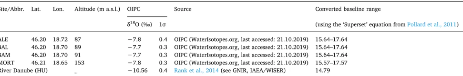
Oxygen isotope analyses provided further information on Neolithic mobility patterns at the studied sites. The oxygen isotope composition of environmental water is related to hydrological processes and en- vironmental settings such as temperature, altitude, latitude, season- ality, the distance to the sea, and climatic conditions (Fricke and O'Neil, 1999; Kohn and Welker, 2005; Luz et al., 1984). By drinking water, the locally available oxygen isotopes are incorporated into teeth and bones of an individual. The δ18O value of human dental enamel can therefore provide information about human geographic origin (Chenery et al., 2012; D'Angela and Longinelli, 1990; Luz et al., 1984). However, fur- ther cultural factors such as food preparation (Brettell et al., 2012; Daux et al., 2008; Wright and Schwarcz, 1998) or breastfeeding (Britton et al., 2015) can also influence the δ18O value of human dental enamel and should be considered in the interpretation of the data. In this study, local oxygen isotope data were calculated with the long-term annual average δ18O value of modern precipitation data (generated by the Online Isotopes in Precipitation Calculator, (Bowen, 2010; Bowen, 2017; Bowen and Revenaugh, 2002; Bowen et al., 2005; Bowen and Wilkinson, 2002) accessible at http://wateriso.utah.edu/
waterisotopes/pages/data_access/oipc.html) ± 1‰, which is the most usual span known from the literature for a local oxygen isotope baseline (Chenery et al., 2010; Gerling, 2015; Hemer et al., 2014;
Knipper et al., 2018; Vohberger, 2011; Wilson and Standish, 2016). The
‘Superset’ linear regression equation (Pollard et al., 2011) was used to convert the δ18O data measured in phosphate into data comparable to modern precipitation data. As far as possible, the standard samples
were analysed three times. The δ18O value for the standard NBS 120c was 22,2 ± 0,3‰ (n = 20 excluding the three outliers), the δ18O value for the in-house standards of synthetic hydroxyapatite (HAP) was 17,12 ± 0,2‰ (n = 24) and the δ18O value for Roman pig bones from the site of Dangstetten (SUS-DAN) was 14,19 ± 0,2‰ (n = 22). The results correspond to the expected values of these standards using the TC/EA methods (Chenery et al., 2010; Knipper et al., 2018; Pellegrini et al., 2016).
5. Results
Prior to the interpretation of the isotope baseline and the results of the strontium and stable oxygen isotope values of the sampled in- dividuals, the potential landcover and Holocene landscape develop- ment needs to be considered. This chapter not only covers the results of the bioarchaeological data, but also a brief overview of the pa- laeoenvironmental considerations that derived from the digital multi- variate modelling. The analysis reveals potential land-use patterns and thus enables the interpretation of site-specific common or distinct local human-landscape interaction, subsistence, and mobility patterns.
5.1. Palaeolandscape and potential agricultural strategies
Potential agricultural strategies within a 3 km distance around the sites have been estimated using multi-layered environmental data in a GIS (Fig. 3 A–D). The soil texture and units at Alsónyék are mostly characterised by meadow soils and relocated alluvial and colluvial deposits from the rivers Sárvíz and Lajvér, which produced a rather mixed material composition. Due to immediate water availability, the Table 3
Human bone, faunal dental enamel, and shell samples for the determination of strontium isotope baseline.
Sample Sample category Sample type Grave/Feature No. 87Sr/86Sr 2 σ
Alsónyék, Hosszú dűlő (Sopot)
ALEM shell Bivalvia 1176/222 0.70925 0.00002
ALEO faunal dental enamel Ovis / Capra 1096/0189 0.70932 0.00001
ALES1 faunal dental enamel Sus domesticus 1189/0190 0.70976 0.00001
ALES2 faunal dental enamel Sus domesticus 1189/0190 0.70928 0.00001
ALES3 faunal dental enamel Sus domesticus 1176/0222 0.70900 0.00006
Bátaszék, Lajvérpuszta (Lengyel)
BAL9 human bone Femur right 65 0.71009 0.00003
BAL13 human bone Tibia left 71 0.71002 0.00004
BAL19 human bone Femur left 41 0.71007 0.00002
BAL21 human bone Femur 50 0.70997 0.00005
BAL25 human bone Femur right 93 0.71001 0.00002
BAL26 human bone Femur left 94 0.70993 0.00004
BAL27 human bone Femur right 97 0.70999 0.00005
BALC faunal dental enamel Cervus elaphus 3338/252 0.70981 0.00001
BALS faunal dental enamel Sus domesticus 7223/416 0.70983 0.00002
Bátaszék-Mérnökségi Telep (Starčevo)
BAMM1 shell Bivalvia 708/584 0.70933 0.00006
BAMM2 shell Bivalvia 800/2537 0.70945 0.00006
BAMS1 faunal dental enamel Sus domesticus 1024/3411 0.70967 0.00001
BAMS2 faunal dental enamel Sus domesticus 1460/2357 0.70929 0.00001
BAMS3 faunal dental enamel Sus domesticus 276 0.70965 0.00001
BAMS4 faunal dental enamel Sus domesticus 800/2537 0.70980 0.00001
Mórágy-Tűzkődomb B1 (Lengyel)
MORT1 human bone Femur 15 0.70975 0.00005
MORT2 human bone Femur 16 0.70972 0.00001
MORT4 human bone Femur 43 0.7097 0.00005
MORT6 human bone Femur 46 0.71000 0.00004
MORT7 human bone Femur 47 0.70989 0.00007
MORT12 human bone Femur 56 0.70990 0.00003
MORT16 human bone Femur 60 0.71013 0.00005
MORT18 human bone Femur 63 0.70964 0.00003
MORTM shell Bivalvia 1986.VI.26B/IX 0.70882 0.00005
MORTS1 faunal dental enamel Sus domesticus 1983.VII.28B/VIII 0.70960 0.00001
MORTS2 faunal dental enamel Sus domesticus 46 0.70927 0.00002
MORTS3 faunal dental enamel Sus domesticus 1984.VI.26B/IX 0.70910 0.00002
MORTS4 faunal dental enamel Sus domesticus no data 0.70947 0.00002