BURIAL MOUNDS, CIRCULAR ENCLOSURES AND BEYOND Complex archaeological investigation of Roman-period barrows in the Great Hungarian Plain using non-destructive survey methods
Zsófia Masek – Gábor serleGi – bence VáGVölGyi
Hungarian Archaeology, Vol. 8 (2019), Issue 4, pp. 19–27, https://doi.org/10.36338/ha.2019.4.3
This paper presents the aims and results of the project titled “Non-destructive archaeological research of Roman-period barrow cemeteries in the Great Hungarian Plain.”1 The fundamental goal of this project was to map surface and subsurface phenomena using non-destructive methods. Four Sarmatian cemeteries were investigated during the project, all of which were situated in the Great Hungarian Plain. The results make a significant contribution to our understanding of the spatial arrangement of Sarmatian burial sites.
INTRODUCTION
In the past decades many theories were formulated about the peoples buried in barrow cemeteries in the Great Hungarian Plain. In the beginning, the barrows were interpreted as traces of ethnic communities who sepa- rated themselves from the Sarmatians, and this is still a recurring element in archaeological interpretations.
Most of the sites which have been considered significant reference points in the modern literature were excavated in the 19th or the early 20th century. Thus, it has been a long due obligation of Hungarian archaeol- ogy to properly study these sites using modern methods. Notably, excavations in the past paid little attention to the environment of the mounds including the circular features around them, and it was expected that new investigations covering large areas would yield significant new data. Site localization often remains problem- atic because they were not properly documented and registered in the currently available official site register.
The presence of enclosures around the barrows and the shapes of these features have been among the highly debated issues of archaeological interpretation. Investigations in the second half of the 20th century already pointed out that in the Great Hungarian Plain certain Roman-period graves were enclosed by ditches.
It was, however, a matter of debate whether there were mounds inside these ditches, which had since weath- ered off, or these mounds should be considered as elements of an entirely different rite. The function of the uninterrupted or interrupted enclosures, as well as those having different shapes (e.g. square)—the lat- ter occur relatively rarely—is still uncertain.
The reconstruction of graves enclosed by ditches is still the subject of debates, since this could be based primarily on Sarmatian cemeteries found more recently, during pre- ventive excavations.
Therefore we decided to approach the cemetery types and grave structures from a viewpoint different from the one applied in earlier research. Instead of focusing on the recently documented sites where burial mounds were absent we focused on those barrows which were dated to the Roman period with certainty, taking up the thread of on-site research following at least a hun- dred-year-long tradition (Fig. 1).
1 Scholarship for Young Talents of the Nation, National Talent Programme, NTP-NFTÖ-18-B-0401. Duration: from 1 January to 30 June 2019.
Fig. 1. Results of the magnetometer survey carried out in the area of the mounds in Vaskút
RESEARCH QUESTIONS AND OBJECTIVES
Burial mounds caught the interest of both amateur and professional researchers very early on. Methods of excavation in the past, however, cannot be compared to modern standards, and in fact, these early excava- tions contributed to the destruction of the mounds (in addition to agricultural activities and natural erosion).
Their locations had often been forgotten and could be clarified only with the help of archival data.
In his ground breaking work on the Sarmatian period of the Great Hungarian Plain, Mihály Párducz classified Sarmatian burials into two categories, namely those with and without barrows (Párducz, 1950).
A few years later the first example of a Sarmatian burial site with a circular enclosure came to light, with a south-oriented “entrance” (zalotay, 1953). The reconstruction of such interrupted enclosures remained, however, problematic ever since. It has been noted fairly early that the small barrows within the enclosures above the graves could have been completely destroyed by agricultural activities, leaving no trace, but apparently this process of destruction was impossible to evidence (Vaday, 1989, pp. 197–203). Although the mounds and the enclosures are regarded as separate elements of burial rites (Kulcsár, 1998, pp. 35–47), one should consider, in any case, that the earth from the ditches may have generally been deposited right above the graves.
Research has revealed that both rites are present at certain sites, and unmarked graves were also found among the mounds with closed or open enclosures (Kőhegyi, 1971). In other cases it seems likely that the enclosed graves are, in fact, traces of mounds—this, however, could be attested only by toponymic evi- dence, since there are no detectable traces of mounds left on the surface (e.g. in the case of Tatárhányás- dűlő at Abony, ‘tatárhányás’ meaning ‘earthen heaps made by the Tartars’ in Hungarian, see gulyás, 2011).
Based on the example of the Rákoscsaba and Madaras cemeteries it was suggested that Sarmatian burial mounds were not always enclosed by ditches, and/or the remains of these ditches only rarely survived, not even in those cemeteries where graves with circular enclosures were present (Nagy, 2018). Yet another direction of research is the spatial analysis of the cemeteries, which led to the discovery and evaluation of their centralized structure (Kulcsár, 1998, pp. 75–85; gulyás, 2011).
Meanwhile the analysis of grave finds from earlier excavations continued. This generally demonstrated that most of these graves had been heavily disturbed and robbed. Although the interpretation of the finds has been subject to debates, one thing seems certain: starting from the 2nd century, population groups in the Great Hungarian Plain erected mounds over their graves and this practice continued into the Late Sarmatian – Hunnic period (Vaday, 1986; Kulcsár, 1998, p. 43; Kőhegyi – Vörös, 2011, pp. 356–360). The present state of research suggests social and ethnic differences in the background of this particular practice.
The review of sites suggests that the number of graves in the cemeteries could be much higher than ear- lier suspected, e.g. in the case of Madaras. Therefore it is uncertain what types of cemetery the documented barrows actually belong to, what was the full size of these cemeteries, and how long they were in use. It is also subject to debate whether they represent just one population group or, rather, different groups of immi- grants arriving from the East, and if so, what eastern connections they had.
The spatial analysis of the cemeteries has the potential to yield data on social patterns. In addition to the re-evaluation of earlier excavations, the localization and exploration of new sites by modern methods can contribute to a better understanding of the material culture also of the disturbed and robbed graves. In connection with burial sites the excavation of the respective settlements may be the next stage, which may provide more data on the Sarmatian high-rank social groups. New investigations utilizing modern methods will be instrumental for inventorying and more actively protecting such sites; at the moment their safe- guarding cannot be guaranteed due to the imprecise and vague nature of data.
NON-DESTRUCTIVE SURVEY METHODS
As summarized above, the archaeology of Roman-period burial mounds in the Great Hungarian Plain holds a number of questions that were not yet possible to answer fully before. The aim of our project was to approach these issues from a novel perspective using non-destructive methods, to survey the surroundings
of the mounds, thereby gaining more information on their environment and possibly identifying contempo- raneous features in their vicinity. The applied methodology included various techniques and analyses, all of them exploring certain physical characteristics of the sites without disturbing the soil and the archaeological features. This includes, for example, observing the micro-relief in elevation, vegetation growth, or small differences in the magnetic properties of the soil. These parameters may indicate the presence of archaeolog- ical features and tell us about their character. However, it is important to bear in mind that it is through the combination of different methods that one can produce reliable results, as singular methods can only show certain parts of the whole picture. Therefore, when planning non-destructive investigations, the character of the archaeological features has to be considered and the methods to use have to be chosen accordingly.
In the framework of our present project we are aiming to map the location of subsurface phenomena—
graves and enclosures—against features shown by the micro-relief of the surface, often undetectable to the naked eye. In order to realize this goal, geomagnetic survey and 3D photogrammetry were applied, combined through the use of high precision GPS surveys. In order to exploit these techniques effectively, however, we first had to identify and localize the sites with the highest possible precision. For this, we had to rely on a wide range of sources to accomplish this, including previously published archaeological liter- ature, databases of archaeological documentation, archive maps (military, cadastral and other manuscript maps), as well as archival and recent aerial photos, and satellite images, which could often reveal the visible signs of burial structures on the surface. The information obtained this way was instrumental in designing targeted surveys and thus optimizing the collection of field data within the financial margins available to us.
For the detection of subsurface phenomena, a so-called passive geophysical method (geomagnetic sur- vey) was applied. This technique uses a magnetometer to measure the magnetization of the local physical environment against that caused by the background radiation. Through the analysis of anomalies in this characteristic it can detect subsurface archaeological features, and other anthropogenic disturbances in the natural environment. Such anomalies can clearly indicate areas where human disturbance was intensive or long-term, and where substantial quantities of certain materials significantly different from their environ- ments (e.g. burnt brick or stone) were present.
During our research we have also conducted surveys of the local surface relief, in order to map the possible surface traces of burial mounds and the landscapes around them, using drone photos and 3D photogramme- try. This technique is based on photographic data recorded with drones flying at medium altitude, and on a comparative analysis of the relative position of features documented in the photos (De Reu et al., 2013). By using these methods, it is possible to create high-resolution point clouds and 3D models of any object. Further adding geolocated markers also allows for a georeferenced terrain model (Westoby et al., 2012) to be created.
With such models it is possible to identify the tiniest surface traces of the mounds and to get a more accurate picture of their environment. Additionally, high resolution orthographic photos can be taken using the same method in order to study discolorations of surface vegetation, also often alluding to archaeological features.
RESULTS VasKút, töRöK-DomboK (‘tuRKish hills’)
The earliest excavation of the Sarmatian burial site in Vaskút was conducted in 1868 by Flóris Rómer and by members of the local landowner bourgeoise. Four out of the twelve then extant and identifiable burial mounds were dug up, all of which had already been heavily robbed. The unique findings of these excava- tions first of all provides evidence on the grave structures—chamber graves—of the mounds. There was also a circular earthwork identified in their vicinity, however, its function and chronology remained ambig- uous; the Celtic or Roman period was suggested (Kőhegyi – VöRös, 1999; Vörös, 2002; maseK, 2014;
CzajliK – holl, 2015, pp. 66–68).
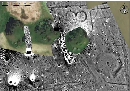
The burials in Vaskút formed two distinctive groups. The northern cemetery was the only one among the investigated sites which did not have to be re-identified, as three barrows remained and are still visible on the surface. They are situated in an area now left untouched by agricultural cultivation (Figs. 1–2). Our surveys in
their vicinity made it possible to identify the other mounds documented in the mid-19th century. The northern group consisted of five mounds altogether, which were of similar size (Fig 4a). The eastern two of them have been completely destroyed by now due to intensive ploughing and were identified only through geomagnetic survey (Fig. 3). The easternmost one had a circular, interrupted enclosure with a causeway on the southern side. The one in the middle (i.e. the easternmost one among the three extant mounds) probably also had a circular enclosure around it. Therefore the burial rite of the undoubtedly Roman-time huge mounds at Vaskút seems to have been identical to the Sarmatian-period burials with interrupted enclosures.
In addition to the already documented barrows we were also able to identify previ- ously unknown mounds with circular enclo- sures; however, the evaluation of these data is challenging due to modern disturbances.
Notably, the northern group consists of mounds of different sizes, arranged in a cen- tralized layout, whereas the southern group consisted of a few large mounds only. These were also enclosed by circular ditches, some of which had, without doubt, openings towards the south (Fig. 4b).
Settlement traces, the dating of which remains yet uncertain and to be investigated in the future, were identified between the two groups. Notably, superpositions could be observed in the area of the northern group, between the mounds and the settlement fea- tures, and also between the enclosures of the two largest and fully destroyed mounds. This indicates a chronological difference that has yet to be clarified.
Our results confirmed that the burials in the southern group are aligned with the northern side of the circular earthwork, thus, the earthwork either predates the Sarmatian cemetery or they are contemporaneous.
hoRtobágy-KistatáRüléseKaND
hoRtobágy-PoRoshát (baRRoWgRouP Xi) In 1911–1914 Lajos Zoltai investigated alto- gether 228 graves, in 11 different groups,
Fig. 2. High-nature value Sarmatian mounds in Vaskút
Fig. 3. Geomagnetic survey of the northern mounds in Vaskút, Török-dombok
Fig. 4. Vaskút, Török-dombok, a – the 19th-century situation plan of the two mound groups, after RómeR, 1878, fig. 54; b – Geomagnetic
survey of the southern mounds (cemetery “B”)
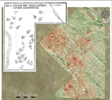
in the area of Hortobágy-Poroshát (zoltai, 1941; Párducz, 1941). A considerable num- ber of weapons were found in the graves and this fuelled various theories. The interpreta- tions usually considered the graves as one unit, although they were scattered in different places occupying an area of about 10 km2 in total. Some of them were situated far away from each other and could be part of separate cemeteries, others were, however, too close to one another to be interpreted with certainty as individual cemeteries. Until a full revision of these excavations is made, the cemeteries of Hortobágy should be referred to as a site complex consisting of 11 groups of burial mounds. Zoltai was also excavating other grave groups beyond the area of Poroshát, for example in the area of Kistatárülések and Nagytatárülések. During the excavation, only the central graves of the visible mounds were excavated. On the other hand, Zoltai was also the first to make observations concerning the enclosures around the mounds.
Some of the grave groups were found in areas that had once been cultivated as rice fields, while others were situated in saline landscapes, i.e. uncultivated pasture lands.
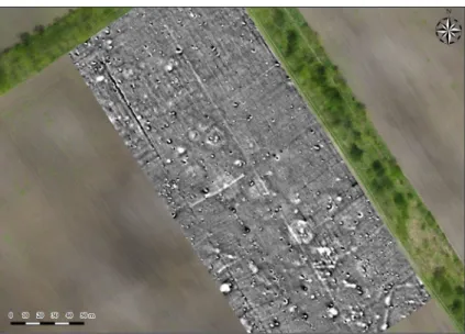
This offered a favourable context to explore the taphonomic differences resulting from environmental conditions and agricultural cultivation. Following the methodological consideration to choose sites with different environmental conditions and state of preser- vation, we have selected Barrow Group XI at Hortobágy-Poroshát and Kistatásülések. The former one is situated in a low-lying area—a salt meadow—and it is potentially inform- ative also from an environmental histori- cal point of view (Fig. 5). The latter is sur- rounded by an area that had been cultivated by flood irrigation; however, the traces of the mounds are still identifiable through soil dis- colorations visible in photographs (Fig. 6).
The geophysical survey of the Kistatár- ülések site revealed many circular features, large and small alike. Their locations corre- spond to the pattern of soil discolorations vis- ible on satellite images. In some cases, traces of these phenomena, which are slightly ele-
Fig. 5. Geomagnetic survey of the barrows in Hortobágy
Fig. 6. Hortobágy - Kistatárülések, a – Plan of the cemetery, after Zoltai, 1941; b – drone photo showing discolorations in connection
with the mounds
Fig. 7. Results of the geomagnetic survey projected onto the ortographic image of the Hortobágy-Kistatárülések site
vated from the surface relief, can be observed also in the photogrammetric survey, undoubtedly indicating the location of the mounds. The structure of the cem- etery, revealed this way, matches the site plan pub- lished by Zoltai (Fig. 7), but in addition to the features he excavated, other circular enclosures and structures of different sizes were identified, thus increasing the area of the site, mainly to the northwest. A few ques- tions on the chronology could be answered too: pre- vious excavations failed to bring to light datable finds from the robbed graves but the results of our surveys and the morphological character of the cemetery con- firmed its dating to the Roman period.
The localization of Barrow Group XI in Horto- bágy-Poroshát was possible on the basis of Zoltai’s map that showed the position of the Koczka stream, a boundary ditch and a boundary mound. Conditions for geomagnetic surveys were not favourable in this area due to the salty alkaline soil. Among the smaller
groups of mounds shown on the site map, only the north-western one could be identified, based on low char- acteristic geophysical anomalies. A 3D photogrammetric survey was not carried out in the area, but a digital elevation model (DEM) could be generated using the GPS data of the magnetometer device. This was instru- mental in localizing the barrow groups indicated by Zoltai in the form of smaller protrusions. The presence of poorly observable circular enclosures in the north-western group and the lack of similar features in the case of other graves visible in the DEM point to the technological limitations of the magnetometer device (Fig. 8).
theCemeteRyof jászalsószeNtgyöRgy – boRsa-halom
In 1899 four mounds were excavated at this site, out of the seven or eight. They were situated around the large burial mound in the centre, i.e. the Borsa-halom. At the end of the 19th century the height of the central mound was 7 m; today, only a 1–1.5 m high terrain remained of it due to continuous ploughing.
Based on the significant, and indeed, unique find- ings, the site could be dated to the Late Sarmatian – Hunnic period (late 4th–early 5th century) (hilD, 1901; staNCziK, 1975; Vaday, 1989; maseK, 2019).
Materials from the collection of archaeological site documentations, military maps, archival maps, aerial photos and satellite images were used to localize the site precisely. Based on archive aerial photos and satellite images one could again argue that the cemetery was much larger than previously suggested and that the burial mounds were enclosed by circular ditches. The digital elevation model that resulted from the photogrammetry survey con- firmed the observations made on the site, outlining the traces of the four excavated mounds (Fig. 9).
The geomagnetic survey, however, failed to pro- duce clear signs in regard to related features. The survey revealed settlement features of a presuma-
Fig. 8. Hortobágy-Poroshát, Group 11, a – Plan of the cemetery after Zoltai 1941; b – Results of the geomagnetic
survey projected onto the DEM
Fig. 9. The cemetery of Jászalsószentgyörgy – Borsa- halom, drone-based 3D photogrammetric image of the area
surrounding the site
bly prehistoric site along a small ridge, of which the barrows are a part. Based on these features we may expect to detect the circular ditches surrounding the mounds.
In the case of the Borsa-halom, unusual, regu- lar features were evidenced (Fig. 10). These can be identified as the trenches of the 1899 excavation. The mound was dissected by two sets of long trenches placed in right angles, oriented—approximately—in N–S direction. Hoping to find other features, another trench was opened on the north-eastern side of the mound, oriented diagonally to the grave chamber.
In the geomagnetic image the northern and eastern side of the long trenches as well as the sondage on the north-eastern side could be observed, but on the south-western side of the mound their traces were not detectable anymore; they could have been ploughed away or their geomagnetic traces disappeared for other reasons. Our survey raised new questions to be answered by targeted investigations in the future.
SUMMARY
In the frames of the project four barrow cemeteries at Vaskút, Jászalsószentgyörgy, and at two other sites in the region of the Hortobágy were investigated with non-destructive methods.
Based on the results we were able to draw a few basic conclusions, filling in the gaps of earlier research, in regard to the location and spatial structure of the sites as well as the character of the respective archae- ological features. The results obtained in each case confirmed and clarified the localization of the sites.
The evidence presented also underlined that the evaluation of barrow cemeteries should not be separated from the study of other Sarmatian burial sites. The obtained data clearly suggested that graves surrounded by interrupted enclosures should be generally interpreted as burial mounds. Sarmatian cemeteries with mounds and enclosures likely remained visible landmarks for centuries, and this consideration is important also when researching the landscape and settlement pattern of the Migration Period.
Our results invite further research concerning the layout of the cemeteries and their environment. It would be particularly important to carry out further, other kinds of non-destructive surveys at Jászalsó- szentgyörgy, e.g. coring campaigns, in order to map soil profiles and provide a more detailed interpretive context for the observations made thus far. The study of the Hortobágy sites made it clear that it is possible to identify even the shallow, almost completely destroyed mounds and enclosures, analysing micro-relief patterns and geophysical measurements. Such complex surveys open new perspectives for the re-evaluation of earlier excavations, highlighting the effectiveness of modern methods. Our current project was certainly the first step as there are many other sites with similar conditions, whose precise localization and control excavation would be desirable in order to obtain a more detailed view on the morphological character and spatial arrangement of Sarmatian cemeteries from the Roman period.
bibliogRaPhy
CzajliK, z., & holl, b., 2015.
Zur topographische Forschung der Hügelgräberfelder in Ungarn. Ein Vergleich der Angaben von Compte- rendu mit den Ergebnissen der Luftbildarchäologie. Dissertationes Archaeologicae 3(3), pp. 59–70. doi:
http://dx.doi.org/10.17204/dissarch.2015.59
Fig. 10. The cemetery of Jászalsószentgyörgy – Borsa-halom, a – Plan of the excavations at Borsa-halom (Hungarian National
Museum, Archaeological repository, detail of the ground plan, published by StancZik, 1975, p. 141); b – Results of the geomagnetic survey of Borsa-halom projected onto the DEM
De Reu, j., Plets, g., VeRhoeVeN, g., etal., 2013.
Towards a three-dimensional cost-effective registration of the archaeological heritage. Journal of Archaeological Science 40 (2), pp. 1108–1121. doi: https://doi.org/10.1016/j.jas.2012. 08.040
gulyás, Gy., 2011.
Szarmata temetkezések Abony és Cegléd környékén [Sarmatian burials around Abony and Cegléd]. Studia Comitatensia 31, pp. 125–253.
hilD, V., 1901.
A jász-alsó-szent-györgyi sír [The grave from Jászalsószentgyörgy]. Archaeologiai Értesítő 21 (2), pp. 120–138.
Kőhegyi, M., 1971.
Előzetes jelentés a Madaras–Halmok későszarmata-hunkori temetőjének ásatásáról (Vorläufige Mitteilung über die Freilegung des spätsarmatisch-hunnenzeitlichen Gräberfeldes von Madaras–Halmok).
Archaeologiai Értesítő 98 (2), pp. 210–215.
Kőhegyi, m., & VöRös, G., 1999.
A vaskúti halmok és földvár (Kutatástörténet és anyagközlés) [Die Hügel und der Erdwall von Vaskút (Forschungsgeschichte und Materialvorlage)]. A Móra Ferenc Múzeum Évkönyve – Studia Archaeologia 5, pp. 217–259.
Kőhegyi, m. & VöRös, G. 2011.
Madaras-Halmok. Kr.u. 2–5. századi szarmata temető [Madaras-Halmok. A Sarmatian cemetery from the 2nd–5th c. AD]. Monográfiák a Szegedi Tudományegyetem Régészeti Tanszékéről. Szeged: Szegedi Tudományegyetem Régészeti Tanszék.
Kulcsár, V., 1998.
A Kárpát-medencei szarmaták temetkezési szokásai [The burial rite of the Sarmatians of the Carpathian Basin]. Múzeumi Füzetek 49. Aszód: Osváth Gedeon Múzeumi Alapítvány.
maseK, Zs. 2014.
Újabb adatok a vaskúti szarmata halomsírok leletanyagának értékeléséhez (Weitere Archivdaten zu der Bewertung der sarmatenzeitlichen Hügelgräber von Vaskút). Folia Archaeologica 55, pp. 53–70.
maseK, Zs., 2019.
Attila sírjának nyomában: A jászalsószentgyörgyi késő szarmata kori halomsíros temető [In the wake of Attila’s grave – The Late Sarmatian-period cemetery of Jászalsószentgyörgy]. In: G. Ilon (ed.), Régészeti nyomozások Magyarországon, Vol. 2. Budapest: Martin Opitz, 2019, pp. 205–224.
Nagy, M., 2018.
A Budapest, XVII. Rákoscsaba, Péceli úti császárkori barbár temető. Kr. u. 2–4. század – Das barbarische Gräberfeld Budapest XVII. Bezirk, Rákoscsaba, Péceli Straße aus der jüngeren Kaiserzeit (2–4. Jahrhundert n. Chr. I-II). Budapest: Budapesti Történeti Múzeum.
Párducz, M., 1941.
Die nähere Bestimmung der Hügelgräber der röm. Kaiserzeit in Hortobágy. In: Laureae Aquincenses memoriae Valentini Kuzsinszky dicatae 2. – Aquincumi babérágak, Kuzsinszky Bálint emlékének szenteli Budapest-székesfőváros közönsége és a Pázmány-Egyetem Érem- és Régiségtani Intézete. Dissertationes Pannonicae Ser. II, No. 11. Budapest, pp. 308–342.
Párducz, M., 1950.
A szarmatakor emlékei Magyarországon, Vol. III (Denkmäler der Sarmatenzeit Ungarns III). Archaeologia Hungarica XXX. Budapest: Országos Magyar Történeti Múzeum.
RómeR, F., 1878.
Compte-rendu de la huitième session, Budapest 1876. Second volume, I. partie. Résultats généraux du mouvement archéologique provoqué en Hongrie. Budapest.
staNCziK, I., 1975.
Szolnok megyei régészeti adatok Hild Viktor jegyzeteiből [Archaeological data about Szolnok County from the notes of Viktor Hild]. Szolnok Megyei Múzeumi Adattár 25–26. Szolnok: Damjanich János Múzeum.
Vaday, A., 1986.
Beitrag zum Fund von Vizesd-puszta (Megjegyzés a Vizesd pusztai lelethez). Folia Archaeologica 37, pp.
197–223.
Vaday, A., 1989
Die sarmatischen Denkmäler des Komitats Szolnok. Ein Beitrag zur Archäologie und Geschichte des sarmatischen Barbaricums. Antaeus 17–18. Budapest: MTA Régészeti Intézet.
Vörös, G., 2002.
A vaskúti szarmata halmok leletei (Adatok a szarmata koporsók és gerenda-kamrák köréhez). Die Funde der sarmatischen Hügel von Vaskút (Angaben zum Kreis der sarmatischen Särge und Balkenkammern). A Móra Ferenc Múzeum Évkönyve – Studia Archaeologia 8, pp. 157–176.
Westoby, m. j., bRasiNgtoN, j., glasseR, N. f., hambRey, m. j., & ReyNolDs, j. m., 2012.
‘Structure-from-Motion’ photogrammetry: A low-cost, effective tool for geoscience applications.
Geomorphology 179, pp. 300–314. doi: https://doi.org/10.1016/j.geomorph.2012. 08.021 zalotay, E., 1953.
A prochorovkai temetkezési szokás nyomai az alföldi szarmatáknál (Следы прохоровского способа погребения у сармат, проживавших на венгерской низменности). Archaeologiai Értesítő 80 (1), p. 63.
zoltai, L., 1941.
Die Hügelgräber der römischen Kaiserzeit in Hortobágy. In: Laureae Aquincenses memoriae Valentini Kuzsinszky dicatae 2. – Aquincumi babérágak, Kuzsinszky Bálint emlékének szenteli Budapest-székesfőváros közönsége és a Pázmány-Egyetem Érem- és Régiségtani Intézete. Dissertationes Pannonicae Ser. II, No. 11.
Budapest, pp. 269–308.