Auroville’s Disappearing Beaches
Boglárka Nagy
49Abstract
On February 28th 1968, the town of Auroville was solemnly funded in India with the aim of searching for solutions to humanity’s most pressing questions. Over the past 50 years the heavily eroded area has undergone exemplary landscape rejuvenation and a small town has been formed with 3000 residents from 54 countries of the world.
National governments, international organizations and universities support and observe the development of this experiment.
The majority of Auroville’s land is a few km away from the Coromandel Coast, but there are a few shoreline settlements that serve as centers for recreational and beach activities. In recent years the coast has undergone rapid erosion which has washed away beaches and buildings, and despite attempts to minimize this it is an ongoing process.
Investigation suggests that the new port development in Pondicherry, a few km south of Auroville, is the main cause of the destruction. As the shores disappeared the groundwater became salinized. The primary sufferers of the change are those in coastal settlements:
resorts and fishing villages. The affected coastline extends across the borders of two states:
Tamil Nadu and Pondicherry, and constructive proposals are often lost in political battles.
In my research paper, which is based on interviews and literature analysis, I aim to outline the situation. I describe the attempts that were made to stop the destruction and to initiate cooperation of local stakeholders within the various layers of society, and to target the decision makers at state and national level.
Keywords: coast erosion, Coromandel Coast, climate change, landscape rehabilitation, Pondicherry Harbour
49 Doctoral School of Landscape Architecture and Landscape Ecology, Szent István University; Auroville Hungary Association, Hungary; aurovillehungary@gmail.com
I. Introduction
The experimental town of Auroville was founded in 1968 in South India. The urban concept is based on Sri Aurobindo’s work and philosophy, and the town plan was developed by Mira Alfassa and Roger Anger.
Young people from around the world moved to Auroville in the 1970s. In those years the landscape was devastated. The trees were cut during the British times, and the local monsoon climate with its heavy rains has eroded the land. The first pioneers started reforestation work in order to turn
¯¯¯¯¯¯¯¯¯¯¯¯¯¯¯¯¯¯¯¯¯¯¯¯¯¯¯¯¯¯¯¯¯¯¯¯¯¯¯¯¯¯¯¯¯¯¯¯¯¯¯¯¯¯¯¯¯¯¯¯¯¯¯¯¯¯¯¯¯¯¯¯¯¯¯¯¯¯¯¯¯¯¯¯¯¯¯¯¯¯¯¯¯¯¯¯¯¯¯¯¯¯¯¯¯¯¯¯¯¯¯¯¯¯¯¯¯¯¯¯¯¯¯¯¯¯¯¯¯
the environment more suitable for human conditions. Intense works were done for decades, and today the land is a luscious area with more than 5 million trees. As the forest grew and offered protection from the heat and the rain, more and more inhabitants settled in Auroville.
Today approximately 3000 habitants live in Auroville, among them twice as many adults as children, and about the same number of man as women.
Auroville’s inhabitants represent 56 countries, most of the residents are from India. Available data shows that the age is balanced, and in past decades the number of habitants has been increasing in an accelerating movement (ARS 2018), so the original idea to reach
50 thousand habitants does not seem so unrealistic after all.
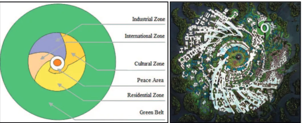
The master plan of Auroville divided the town into 6 areas, that includes a galaxy shaped township and a 1.5 km wide outer green belt around it (Figure 1).
The central point of the Auroville Master Plan area is a single standing banyan tree that is one of the sacred trees of India. This tree was already on its place when the location was chosen, so we can say that the town was built around a tree. Next to it is the Matrimandir (Temple of the Mother) a golden globe with various rooms for silent meditation. The surrounding gardens compose the Peace Area, from where the roads and zones of the galaxy originate (Figure 2).
Figure 1: The Zones of Auroville as in the Master Plan
Source: Tensi
Figure 2: The Urban Design of Auroville is galaxy shaped Source: Auroville Archives
¯¯¯¯¯¯¯¯¯¯¯¯¯¯¯¯¯¯¯¯¯¯¯¯¯¯¯¯¯¯¯¯¯¯¯¯¯¯¯¯¯¯¯¯¯¯¯¯¯¯¯¯¯¯¯¯¯¯¯¯¯¯¯¯¯¯¯¯¯¯¯¯¯¯¯¯¯¯¯¯¯¯¯¯¯¯¯¯¯¯¯¯¯¯¯¯¯¯¯¯¯¯¯¯¯¯¯¯¯¯¯¯¯¯¯¯¯¯¯¯¯¯¯¯¯¯¯¯¯
The next area around the Peace Area is divided into four zones. The 189-acre Residential Zone with parks and various height buildings offer space for individual and community life. The area can be built up to 45 percent and is designed for at least 55 percent green (Thomas, H. – Thomas, M.
2013). The Cultural Zone is the centre of education and artistic expression. Here are the schools, concert halls, theatres and sports facilities. The 109-acre Industrial Zone focuses on Auroville’s self- sustainability and environmentally friendly development through the development of ‘green’ industries.
The 74-acre International Zone is home to national and cultural pavilions and events by continent grouping (Fassbender, F. 2018).
The outer Green Belt is designed as Auroville’s lungs, which surround the inner areas and protect them as a buffer zone and create a unique microclimate. This zone is an area of organic farms and forests that create a living space for wildlife and provide food, herbs and timber for the inhabitants of Auroville. In the Green Belt a small group of Auroville farmers and foresters live, who only use the solar energy.
Their work is done in cooperation and they call themselves Farm and Forest Group. The green belt is planned for 1200 hectares, but
so far only 400 hectare is owned by Auroville. When the area was chosen, lot of effort were put into gaining the ownership of the lands of this area, which at that time were heavily eroded and cheap to buy. The area has gone through exemplary landscape rehabilitation and has become a rich ecosystem. Further extension and proper management of new areas can ensure soil and water quality conservation and groundwater conservation (Nagy B. 2018).
So while the past was a deserted land with no inhabitants, today we have a forest with lots of inhabitants including humans but also a very vivid wildlife.
The town also have experimented and developed various methods for the social and environmental challenges of present times.
According to various climate impact studies, the area of Auroville is expected to become drier and hotter which most likely results more droughts to occur. The incidence of droughts will impact agriculture, and yields are expected to fall significantly. The rainfall will become unpredictable, and the while total amount of rainfall will increase the length of rainy days will shorten, these will create intense rainfalls, and it increase the risk of landslides, sudden floods and other natural disasters. It is
¯¯¯¯¯¯¯¯¯¯¯¯¯¯¯¯¯¯¯¯¯¯¯¯¯¯¯¯¯¯¯¯¯¯¯¯¯¯¯¯¯¯¯¯¯¯¯¯¯¯¯¯¯¯¯¯¯¯¯¯¯¯¯¯¯¯¯¯¯¯¯¯¯¯¯¯¯¯¯¯¯¯¯¯¯¯¯¯¯¯¯¯¯¯¯¯¯¯¯¯¯¯¯¯¯¯¯¯¯¯¯¯¯¯¯¯¯¯¯¯¯¯¯¯¯¯¯¯¯
likely that in the future, the strength and frequency of hurricanes and cyclones will increase. Forecasts show that the already rising sea levels will accelerate in the future.
The expected further increase is 0.35 m by the end of the century, and some coasts will become underwater (Potsdam Institute 2013).
Recent weather events like Hurricane Thane in 2011, the extreme monsoon rainfall during in 2015 monsoon or the drought in 2017 suggests that the landscape rehabilitation methods that were used and developed in Auroville offer certain protection from the impacts of climate change (Nagy B. 2018).
The following case study is about the Auroville beach erosion.
Auroville has a few beaches outside of the original Master Plan area, next to the coast. These beach communities are primarily serve as space for recreation and sea sports for the Aurovillians.
Along the coastline there are other facilities, like fishermen villages, harbours and sites of religious and cultural activities. These coastline communities have gone through extreme erosion during the past decade. This research paper investigates and describes the beach erosion, its causes, effects and rehabilitation attempts.
II. Research Methods
The research was made on a 20-km-long beach area of the Coromandel Coast of India near Auroville where the researcher has been living between 2005 and 2018 and made her personal observations on the changing coastal landscape throughout the years.
The literature review was based on the relevant literatures as listed in the references, and the documentation of the Auroville Coast Erosion Task Force work between 2007 and 2018, approximately 500 pages, was analysed.
Four interviews were made in March and April of 2018 with local experts.
III. Results and Discussion
III.1. The effects of erosion A 20-km-long section of the beach has been noticeably eroded over the last decades, causing economic, environmental, social and cultural damage. The erosion destroyed more than 200 hectares of beach along the Coromandel Coast, Auroville itself lost more than 1 hectare of land. Properties were destroyed including homes and equipment. Relief and
¯¯¯¯¯¯¯¯¯¯¯¯¯¯¯¯¯¯¯¯¯¯¯¯¯¯¯¯¯¯¯¯¯¯¯¯¯¯¯¯¯¯¯¯¯¯¯¯¯¯¯¯¯¯¯¯¯¯¯¯¯¯¯¯¯¯¯¯¯¯¯¯¯¯¯¯¯¯¯¯¯¯¯¯¯¯¯¯¯¯¯¯¯¯¯¯¯¯¯¯¯¯¯¯¯¯¯¯¯¯¯¯¯¯¯¯¯¯¯¯¯¯¯¯¯¯¯¯¯
rehabilitation work was financed by the local government and national and international non- governmental organisations, this also added to the economic loss.
Reoccurring costs are needed for the building and maintenance of the coast protecting hard structures as well as the needed dredging.
The costs are growing steadily, as the seawalls and groins are slowly transferring the erosion along the coast forcing the implementation of new structures (Aurofilio 2002).
As the coast changed, it affected the landscape, human life and its century-old traditions linked to the natural landscape.
Pondicherry was a French colonial town famous for its beaches and promenades. It offered cultural and religious beach festivals as well as recreational and sporting activities. The disappearance of the beaches caused not only socio–economic damage, but also the loss of its cultural identity.
The erosion threatens the safety and livelihood of fishermen, living in the villages along the shore. Traditional fishing in the area could not continue due to the transformation of the beach land. The damage of property and disappearance of traditional fishing methods resulted in a socio–economic crisis and some
estimated 7000 fishermen lost their livelihood and other income generating alternatives offered by tourism (Pondy CAN 2009).
Srikanthan researched a fisherman village of the area and examined the fishermen’s traditions. He found that the profession of traditional fisheries is based on the knowledge of different fishes and the different nets used for each different months. This knowledge has been preserved through generations in folk songs, proverbs and narratives of the village. Srikanthan observed that the work of the fisherman has become unpredictable as the fish, currents and waves no longer follow the old patterns (Srikanthan, S. 2013).
As a result of erosion the sandy beaches disappeared and coastal ecosystems were damaged. Artificial rocky shores have changed the flora and fauna, and the turtles cannot lay their eggs (Narayan, P. 2010). In order to build and maintain the so called hard structures, rocks have to be constantly mined and as they are constantly sinking the rocks must be replaced constantly.
As a consequence, the nearby mountains are destroyed, thus further increasing environmental damage.
¯¯¯¯¯¯¯¯¯¯¯¯¯¯¯¯¯¯¯¯¯¯¯¯¯¯¯¯¯¯¯¯¯¯¯¯¯¯¯¯¯¯¯¯¯¯¯¯¯¯¯¯¯¯¯¯¯¯¯¯¯¯¯¯¯¯¯¯¯¯¯¯¯¯¯¯¯¯¯¯¯¯¯¯¯¯¯¯¯¯¯¯¯¯¯¯¯¯¯¯¯¯¯¯¯¯¯¯¯¯¯¯¯¯¯¯¯¯¯¯¯¯¯¯¯¯¯¯¯
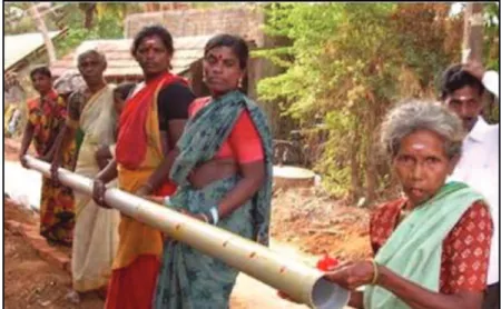
Figure 3: Groundwater restoration project of Auroville in a neighbouring village Source: Auroville Village Action Group
Another major problem is the salt water intrusion into the aquifers causing the salinization of the groundwater which becomes useless for agriculture. Efforts were made to reduce the level of salinization like one experiment in Auroville in coastal villages between 2007 and 2009. During this experiment various methods and technologies were combined to protect the groundwater (Figure 3).
Some parts of the project were successfully implemented, while others did not succeed due to the rising socio–cultural tensions in the villages (Bonnet, C. 2007).
Natural sandy beaches protect the inland from the extreme weather events arriving from the direction of the sea such as hurricanes, tsunamis
or extreme monsoon waves and currents. Recent events such as the tsunami in 2004 or Hurricane Thane in 2012 suggest that artificial rocky shores/hard structures do not provide adequate protection.
III.2. The cause of erosion Satellite imagery shows that sea level rise is ongoing and it is projected to increase. At the same time, this specifically accelerated erosion was not caused by sea level elevation but by artificial interference: the Pondicherry Harbour. The phenomenon of this coast is that the direction of the water currents changes twice a year along the coast resulting in a continuous north–south and south–
¯¯¯¯¯¯¯¯¯¯¯¯¯¯¯¯¯¯¯¯¯¯¯¯¯¯¯¯¯¯¯¯¯¯¯¯¯¯¯¯¯¯¯¯¯¯¯¯¯¯¯¯¯¯¯¯¯¯¯¯¯¯¯¯¯¯¯¯¯¯¯¯¯¯¯¯¯¯¯¯¯¯¯¯¯¯¯¯¯¯¯¯¯¯¯¯¯¯¯¯¯¯¯¯¯¯¯¯¯¯¯¯¯¯¯¯¯¯¯¯¯¯¯¯¯¯¯¯¯
north movement of sand on the shore (Salghuna, N. N. – Bharathavaj, S. A. 2015). In 1986, the Pondicherry Government built a port that acts as a barrier and prevents the natural movement of sand. This caused sand accumulation on the southern side of the harbour and erosion over the north (NIOT 2012).
III.3. A cross-border conflict
The port was built on the territory of Pondicherry, but erosion progresses northwards and has reached the territory of Tamil Nadu.
The implemented hard structure solutions however may offer security for the protected lands, but transfer the problem along the coast to the north, and as the next hard structure is created, the problem is further transferred again. Because of the special location of the states along the coast, the villages alternately fall into Pondicherry and Tamil Nadu, so the built structures of Pondicherry causes erosion in Tamil Nadu. As the erosion slowly extends to north, it will cause problems again on a Pondicherry territory (NIOT 2015).
III.4. Applied Technologies There have been a number of technological experiments over
the last decades, involving national and international institutions and professionals, but no definitive solution has been found yet. Some of the methods are described below.
Coast nourishment, i.e.
replenishment of the flowing sand:
When the Pondicherry Government applied for port approval in 1978, it was designed with a sandy permeable and coastal feed system proposed by the Pune Central Water and Research Station. This system was designed to avoid the erosion of the beach as the accumulated sand was continuously moved by the boats machines from south to north. To maintain this process, an underwater tunnel was built at the entrance of the harbour and was used for dredging along the coasts during the first years.
Unfortunately, as this practice did not continue after the first years, the northern shores began to erode while the sand had accumulated on the southern shores and created a new beach south to the harbour (NIOT 2015).
Hard structures: Since the coast nourishment was not maintained seawalls and groins were built to stop the erosion on the affected coasts. While these so- called hard structures provided an immediate solution to the affected areas, the problem was further transferred to the north with each
¯¯¯¯¯¯¯¯¯¯¯¯¯¯¯¯¯¯¯¯¯¯¯¯¯¯¯¯¯¯¯¯¯¯¯¯¯¯¯¯¯¯¯¯¯¯¯¯¯¯¯¯¯¯¯¯¯¯¯¯¯¯¯¯¯¯¯¯¯¯¯¯¯¯¯¯¯¯¯¯¯¯¯¯¯¯¯¯¯¯¯¯¯¯¯¯¯¯¯¯¯¯¯¯¯¯¯¯¯¯¯¯¯¯¯¯¯¯¯¯¯¯¯¯¯¯¯¯¯
new structure built. As on the newly eroded coasts new groins and seawalls were built, this process has resulted a continuous shift of erosion to the north, this way the erosion originally only a few km long has expanded to 20 km so far, and it continues to spread to the north, as the new structures are built.
The problem with hard structures is that while seemingly they stop the erosion they actually increase it by transferring the problem to the next beach thus causing the spread of environmental
damage. So the question is whether this is a really sustainable technology to protect coast erosion (Pondy CAN 2009).
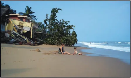
When the groin was built in Thandiyanakuppam village in 2007, coastal erosion developed rapidly northward on the Auroville beaches. Within three months a 100 m long and 70 m wide beach has disappeared on the Quiet Beach of Auroville. Only at this point has Auroville become threatened by the erosion that was already ongoing since 20 years (Figure 4).
Figure 4: Destruction in Auroville beach communities after Thandiyanakuppam groin was built
Source: photo taken by Zsolt Erdélyi
Unsuccessful experiments:
When the erosion started on Auroville two attempts were made to halt erosion. One is a barrier built from tires, the other is a
wall made of palmyra tree trunks.
Unfortunately, both attempts have been destroyed within 2 months by the winter monsoon waves.
¯¯¯¯¯¯¯¯¯¯¯¯¯¯¯¯¯¯¯¯¯¯¯¯¯¯¯¯¯¯¯¯¯¯¯¯¯¯¯¯¯¯¯¯¯¯¯¯¯¯¯¯¯¯¯¯¯¯¯¯¯¯¯¯¯¯¯¯¯¯¯¯¯¯¯¯¯¯¯¯¯¯¯¯¯¯¯¯¯¯¯¯¯¯¯¯¯¯¯¯¯¯¯¯¯¯¯¯¯¯¯¯¯¯¯¯¯¯¯¯¯¯¯¯¯¯¯¯¯
Other technologies:
Technologies have been explored all over the world to stop coastal erosion. Some of these are promising like the geotubes (Shin, E. C. – Oh, Y. I. 2007) or the recently built submarine artificial reef in Pondicherry which is also referred to as a soft structure. While these experiments are costly their efficiency has not yet proven on these coasts.
III.5. Actions of Auroville When the Thandiyanakuppam groin was built in 2007, erosion developed rapidly on the Auroville beaches, destroying its properties and eliminating sandy beaches.
As Auroville fundamentally is a participatory governed community, its residents are actively involved in all aspects of town management.
As a first reaction the Auroville Coast Erosion Task Force team was formed by volunteers in order to gather for joint actions.
As the members met regularly first actions took place very soon. Awareness campaign started to share information and updates within Auroville and its neighbourhood as well as beyond the borders of Auroville and even beyond the borders of India. Local and international experts have been addressed to find technical
solutions. Local and national politicians were asked to lobby for a comprehensive solution addressing the issue. Researches were carried out in cooperation with universities and research institutes to understand the problem and its origins. It was soon realized that the Pondicherry Harbour and the built hard structures are causing the erosion.
As a next step co-operation was initiated between the concerned settlements of the area and a comprehensive plan was designed for protecting the entire coast. The plan, which took 4 years of work, contained 9 groins and one seawall. This plan was approved by the Tamil Nadu Government and money was granted for the building process. When the first seawall was built, a local NGO filed a lawsuit against the initiative and the court stopped all the work with immediate effect. Since then, despite several attempts, no further license has been granted.
IV. Conclusions
Pondicherry Harbour caused a natural disaster that spread slowly along the Coromandel Coast. The erosion has already crossed the border of Tamil Nadu. Although the main reason for the erosion is the harbour the fact remains that sea
¯¯¯¯¯¯¯¯¯¯¯¯¯¯¯¯¯¯¯¯¯¯¯¯¯¯¯¯¯¯¯¯¯¯¯¯¯¯¯¯¯¯¯¯¯¯¯¯¯¯¯¯¯¯¯¯¯¯¯¯¯¯¯¯¯¯¯¯¯¯¯¯¯¯¯¯¯¯¯¯¯¯¯¯¯¯¯¯¯¯¯¯¯¯¯¯¯¯¯¯¯¯¯¯¯¯¯¯¯¯¯¯¯¯¯¯¯¯¯¯¯¯¯¯¯¯¯¯¯
level is rising globally and is likely to continue endangering other coasts of India. No adequate technological solutions were found to protect the sandy shores, and its ecosystems and human cultural heritage. The shoreline is declining, coastal settlements have been destroyed and traditional fishing patterns and recreational sandy beaches have disappeared. In the absence of the beach the mainland became more vulnerable to the waves and hurricanes, and the underground water resources becoming salinized and unsuitable for agriculture. The problem is crossing borders, so it is necessary to cooperate between the states of India. Experience shows that at the moment India does not have the technology to respond rapidly and adequately to the coast erosion. Collaboration is needed where local fishermen’s villages and
Tamil Nadu and Pondicherry States are actively involved to address comprehensively the problem of coast erosion. Unfortunately, such efforts often lose political battles.
For decades, Auroville has established cooperative relationships with local villages and national institutes and ministries. It has many supporters from national and international experts. As an independent organization located in both the states of Pondicherry and Tamil Nadu, Auroville can be a major participant in this crisis. It has done exemplary and successful landscape rehabilitation and rainwater collection work over the last decades (Nagy B. 2018), so with adequate support it might find an appropriate solution not only to its own beaches but to other areas of the Coromandel Coast and other coasts of India.
V. References
ARS 2018: Breakdown by nationality, birth’s ear and Arrival’s year. – Auroville: Auroville Residents Service. – Report, 02. 05.
Aurofilio 2002: The disappearing beach dilemma, Auroville beaches are under imminent threat of being eroded. – Auroville Today, 11.
Bonnet, C. 2007: Salinity Moderating& Proofing of Coastal Aquifers in a Badly Effected Area of the Auroville Bioregion. – Evaluation Report. – Auroville
Fassbender, F. 2018: Inauguration of Auroville, Concept and Purpose. – 50 years Auroville 28. 02. 1968. – 28. 02. 2018. – Prisma
Nagy B. 2018a: Auroville, Pusztaságra épült ökogalaxis. – A Földgömb 35. (01–02.)
¯¯¯¯¯¯¯¯¯¯¯¯¯¯¯¯¯¯¯¯¯¯¯¯¯¯¯¯¯¯¯¯¯¯¯¯¯¯¯¯¯¯¯¯¯¯¯¯¯¯¯¯¯¯¯¯¯¯¯¯¯¯¯¯¯¯¯¯¯¯¯¯¯¯¯¯¯¯¯¯¯¯¯¯¯¯¯¯¯¯¯¯¯¯¯¯¯¯¯¯¯¯¯¯¯¯¯¯¯¯¯¯¯¯¯¯¯¯¯¯¯¯¯¯¯¯¯¯¯
Nagy B. 2018b: Experimented methods to moderate the impact of climate change in Auroville. – Ecocycles Journal 4. (1.) – doi: 10.19040/
ecocycles.v4i1.90
Narayan, P. 2010: Coastal sand dunes „in danger of extinction, need protection”. – The Hindu, 23. 04.
NIOT 2012: Management of coastal erosion along Pondicherry coast. – Status report. – Chennai: National Institute of Ocean Technology, Ministry of Earth Sciences, Government of India, 09.
NIOT 2015: Management of coastal erosion along Pondichery coast.
– Shoreline management plan. – National Institute of Ocean Technology, Ministry of Earth Sciences, Government of India Pondy CAN 2009: Proposal: Restoration of the coastal ecosystems and
livelihoods along the Pondicherry–TamilNadu coast impacted by Man-Induced coastal erosion, 07. – Pondy Citizens Action Network Potsdam Institute 2013: India: Climate Change Impacts. – Report from
the Potsdam Institute for Climate Impact Research and Climate Analytics, Turn Down the heat, Climate extremes, Regional impacts, and Case for Resilience, 09. 06. – Word Bank Press Release
Salghuna, N. N. – Bharathavaj, S. A. 2015: Shoreline Change Analysis for Northern part of the Coromandel Coast. – International Conference on water resources, coastal and ocean engineering. – Aquatic Procedia 4.: pp. 317–324.
Shin, E. C. – Oh, Y. I. 2007: Coastal erosion prevention by geotextile tube technology. – Geotextiles and Geomembranes 25. (4–5.): pp.
264–277.
Srikanthan, S. 2013: Impact of Climate Change on the Fishermen’s Livelihood Development: a case study of village in Coromandel Coast. – IOSR Journal Of Humanities And Social Science (IOSR–
JHSS) 12. (6.): pp. 49–54.
Thomas, H. – Thomas, M. 2013: Economics for People and Earth. The Auroville Case 1968–2008. – Aurolec, Prayogashala: Social Research Centre